BOEM Marine Minerals Program
|
|
|
- Moses Patterson
- 5 years ago
- Views:
Transcription


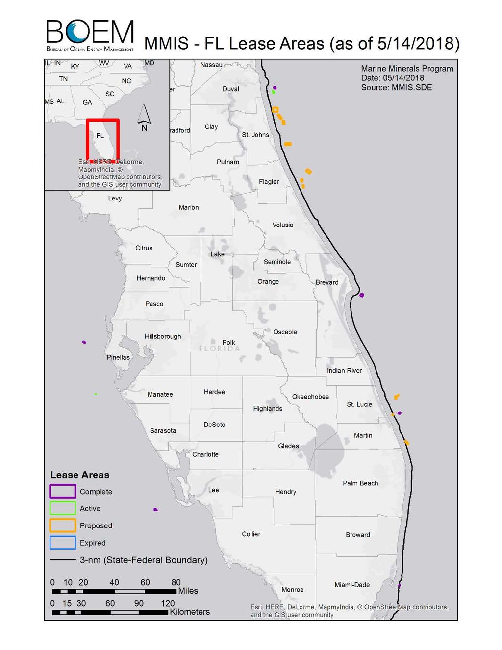
1 BOEM Marine Minerals Program Restoring and Protecting Our Nation s Coasts through Stewardship of OCS Sand Resources SECOORA 2018 Annual Meeting May Doug Piatkowski Douglas.piatkowski@boem.gov BOEM Marine Minerals Program May 31,


2 OUTLINE I. BOEM Overview II. Marine Minerals Program II. Non-Competitive Negotiated Agreements III. Resource Evaluation IV. Environmental Studies Program 2 Marine Minerals Program May 31,

3 BOEM MISSION To manage development of the Nation s offshore energy and mineral resources in an environmentally and economically responsible way. 3 Marine Minerals Program May 31,

4 PROGRAM AREAS 4 Marine Minerals Program May 31,


5 MARINE MINERALS PROGRAM MISSION Facilitate access to and manage the Nation s Outer Continental Shelf (OCS) non-energy marine minerals through environmentally responsible stewardship of resources


6 PROGRAMMATIC BUILDING BLOCKS Leases Managing development of OCS non-energy marine mineral resources Environmental compliance Project monitoring Resource Evaluation National sand inventory initiative Cooperative agreements / ASAP MMIS Resource Management Multiple use conflicts Resource optimization practices Environmental Studies Science informed decision making Collaboration, Partnership, & Communication BOEM / USACE MOU Regional coordination / collaboration
7 NON-COMPETITIVE NEGOTIATED AGREEMENTS Public Law (1994): Allow BOEM to grant noncompetitive negotiated agreements for Federal sand, gravel, or shell resources for use in shore protection or other public works projects. A 1999 Amendment: Prohibits BOEM from charging Federal, state, and local governments a fee for OCS sand. 3 Types of Agreements: 2-Party Memorandum of Agreement (MOA) - Another Federal Agency and BOEM (e.g., Patrick Air Force Base, FL) 3-Party Memorandum of Agreement (MOA) - A Locality (State, county, city, etc.), Another Federal Agency (typically USACE) and BOEM. (e.g., USACE Civil Works.) 2-Party Lease - A Locality (State, county, city, parish etc.) and BOEM. (e.g., USACE Regulatory).


8 8 6 INCREASING DEMAND FOR OCS SAND Agreements Executed


, AK (Gold), VA (heavy minerals), MA (commercial sand) Currently working on")
9 Competitive lease sales for minerals: Lease sales are held on lease blocks COMPETITIVE LEASING Competitive bidding ensues on the lease blocks Leases are sold to the highest bidder Critical Minerals / elements of interest may include: Status Sand, manganese, phosphate, heavy minerals (titanium, zircon), rare earth elements (lanthanides, e.g., neodymium), gold, silver, copper Regulations: 30 CFR 280 (Prospecting), 281 (Leasing), 282 (Operating) Past inquiries: NJ (Salt), AK (Gold), VA (heavy minerals), MA (commercial sand) Currently working on commercial lease processes Strategic importance, revenue source Photo from


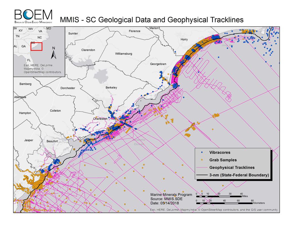
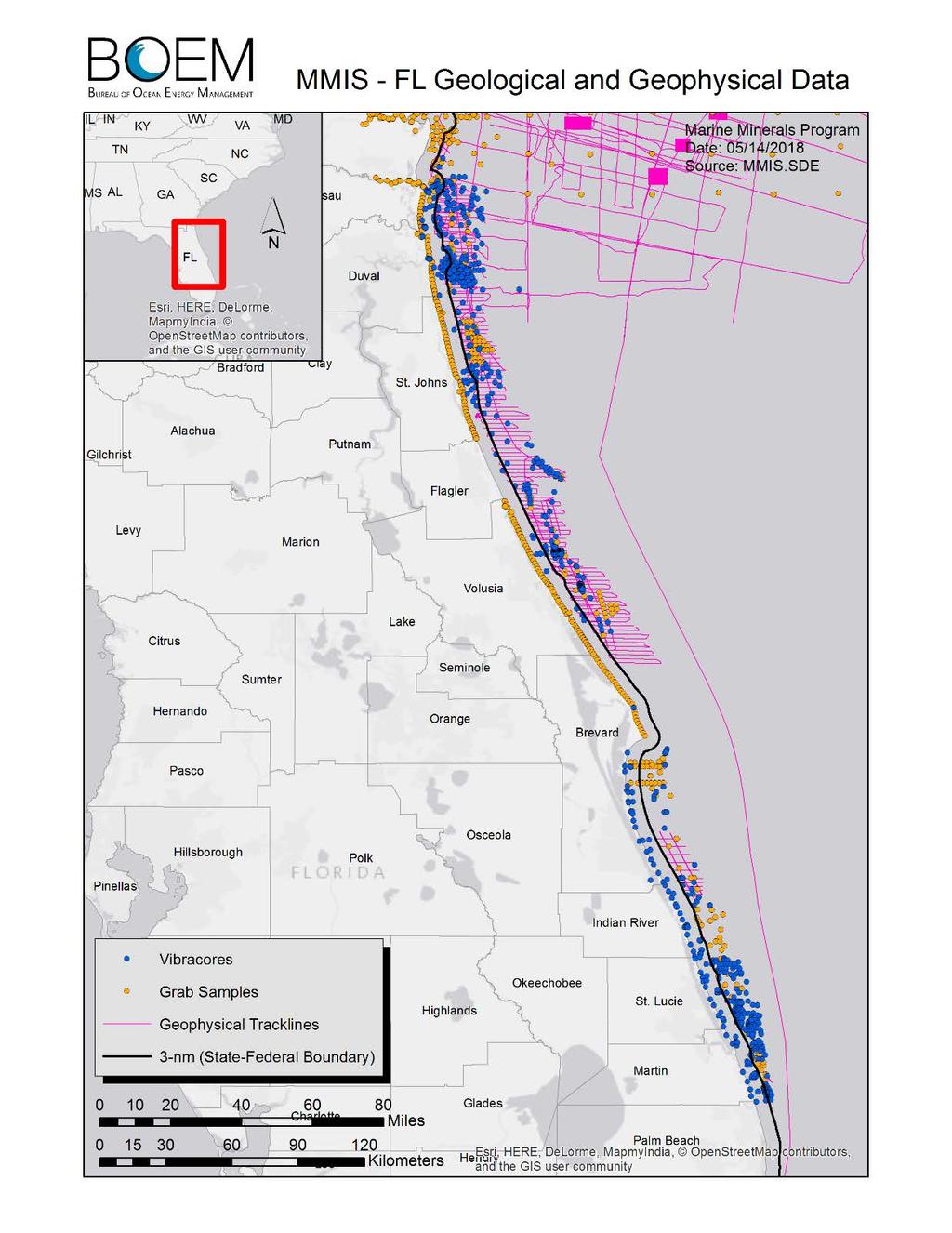
10 RESOURCE EVALUATION National Sand Inventory Goal: We need to know where the resources are to properly manage them Cooperative agreements - Between BOEM and state agencies, local governments, and universities to ID potential sand sources Disaster Relief Appropriations Act: $13.6 million Negotiated Cooperative Agreements with 13 Atlantic Coastal States State Geological Surveys & Associated State Academic Institutions State Agencies Atlantic Sand Assessment Project identification of new potential sand resources Atlantic OCS H.R Emergency Supplemental Bill / South Atlantic Coastal Comprehensive Study
11
12


13 ENVIRONMENTAL STUDIES VISION To be the best research program there is in the context of BOEM s mission and constraints Marine Minerals Program May 31,
 Regional sediment management")
14 MMP SCIENCE STRATEGY MMP science needs road map: Where were we? Where are we now? Where are we going? Primary short-term areas of interest: Improved resource management capabilities National sand resource inventory Habitat inventory (biological, physical, geological) Regional sediment management Continued long-term research on benthic and fish communities Provide the information needed to predict, assess, minimize, and mitigate impacts


15 ONGOING MMP STUDIES Natural Habitat Associations and the Effects of Dredging on Fish at the Canaveral Shoals, East-central Florida. Discerning behavioral patterns of sea turtles in the Northern Gulf of Mexico to inform management decisions Sediment sorting during coastal restoration projects: implications for resource management, environmental impacts, and multiple use conflicts Regional Essential Fish Habitat Geospatial Assessment and Framework of Offshore Sand Features Ecological Function and Recovery of Biological Communities within Sand Shoal Habitats within the Gulf of Mexico Assessing biological processes that drive fisheries productivity on New England Sand Shoals, determining costs to fisheries as a result of sand mining. 15


16 NATURAL HABITAT ASSOCIATIONS AND THE EFFECTS OF DREDGING ON FISH AT CANAVERAL SHOALS Canaveral Offshore Shoal Habitat: Essential Fish Habitat Prominent ridge-swale features and shoal complexes More info needed: Small-bodied demersal and keystone pelagic fish species Movements on a local and regional scale Short-term and longer-term for coastal fish species Characterization and assessment of habitat value and function


17 ACOUSTIC TELEMETRY TO MONITOR FISH RESPONSE TO DREDGING IN A SHOAL HABITAT 712 total animals tagged since late Some fish tracked for > 4 years Detections of > 200 tagged animals from other regions as far as S. FL, DE, MA, and NY 10 Atlantic Sturgeon

18 FISH TELEMETRY

 WAVE")
19 Our uses: Expand fixed receiver arrays Acoustic monitoring of fishes Basic oceanography Equipment: Vemco VR2W Receiver GPS Air/SST Weather Station Remora Passive Acoustic Recorder Fluorometer AIS (non-recording used for collision avoidance) WAVE GLIDER OPERATIONS
20 ECOLOGICAL RECOVERY STUDY Determine functional biological services that are potentially compromised by dredging sand; determine degree of impact Monitor the effects and recovery of sand dredging activities on biological communities of ridge-swale habitats Determine the forcing events in seasonal sediment transport in the bottom boundary layer. Investigate the mechanism of recovery of invertebrate and fish communities associated with the ridge-swale habitats
 Habitat classification based on sediments,")
21 ECOLOGICAL RECOVERY STUDY Biological, geological and physical sampling: Bathymetric surveys Water quality testing (flourometer) Chlorophyll Isotopes Phytoplankton Zooplankton Invertebrates Bottom fishes ADCP deployments (towed and moored) Habitat classification based on sediments, depth


22 ADDITIONAL INFORMATION Website: ESPIS: Fact sheets: MARINE MINERALS FACT SHEET HURRICANE SANDY FACT SHEET ATLANTIC SAND ASSESSMENT FACT SHEET SEA TECHNOLOGY MAGAZINE ARTICLE Contact us: Doug Piatkowski Physical Scientist / Marine Biologist Division of Environmental Assessment Douglas.piatkowski@boem.gov
A National Outer Continental Shelf Sand / Sediment Inventory
 A National Outer Continental Shelf Sand / Sediment Inventory Sand Resource Areas Lease Areas Lora Turner December 15, 2016 Restoring and Protecting Our Nation s Coasts through Stewardship of OCS Resources
Regional-scale understanding of the geologic character and sand resources of the Atlantic inner continental shelf, Maine to Virginia
 Regional-scale understanding of the geologic character and sand resources of the Atlantic inner continental shelf, Maine to Virginia Workshop on Dredging, Beach Nourishment and Bird Conservation Atlantic
Alexandra Carvalho, Ph.D., GISP Kathy Fitzpatrick, P.E.
 Coastal Data Organization for Project Management and Coastal Planning Martin County, Florida Alexandra Carvalho, Ph.D., GISP Kathy Fitzpatrick, P.E. Outline County Coastal Programs Coastal Geodatabase
Introduction: The Gulf of Mexico Alliance. The Gulf GAME project MERMAid and PHINS Results & Conclusions What s next? Examples
 AAG Las Vegas March 25, 2009 Introduction: Ocean governance and Ecosystem-Based Management The Gulf of Mexico Alliance Habitat Identification and Characterization The Gulf GAME project MERMAid and PHINS
A Boundary Delineation System for the Bureau of Ocean Energy Management
 A Boundary Delineation System for the Bureau of Ocean Energy Management Doug Vandegraft Chief, Mapping and Boundary Branch BOEM Esri Ocean GIS Forum - 2015 Outline Introduction BOEM Marine Cadastre Background
Marine Spatial Planning Leslie-Ann McGee Battelle Memorial Institute
 Marine Spatial Planning Leslie-Ann McGee Battelle Memorial Institute Rev061708 1 Marine Spatial Planning What is it? Why is it different? Where is it currently being employed? What is happening in the
Air Quality Modeling from the Offshore Energy Sector in the Gulf of Mexico: An Overview for the Oil and Gas Industry
 Air Quality Modeling from the Offshore Energy Sector in the Gulf of Mexico: An Overview for the Oil and Gas Industry Jose L. Hernandez Bureau of Ocean Energy Management New Orleans, LA Presented at American
A Boundary Delineation System for the Bureau of Ocean Energy Management
 A Boundary Delineation System for the Bureau of Ocean Energy Management Doug Vandegraft Chief, Mapping and Boundary Branch BOEM Coastal Geotools - 2015 Outline Introduction BOEM Marine Cadastre Background
Coastal Response Research Center. Nancy Kinner University of New Hampshire (UNH) Michele Jacobi NOAA ORR. September 27, 2007
 Michele Jacobi NOAA ORR. September 27, 2007") Coastal Response Research Center Nancy Kinner University of New Hampshire (UNH) Michele Jacobi NOAA ORR September 27, 2007 1 Coastal Response Research Center (CRRC) CRRC is partnership between NOAA s Office
Coastal Response Research Center Nancy Kinner University of New Hampshire (UNH) Michele Jacobi NOAA ORR September 27, 2007 1 Coastal Response Research Center (CRRC) CRRC is partnership between NOAA s Office
OCEANOGRAPHIC DATA MANAGEMENT
 OCEANOGRAPHIC DATA MANAGEMENT Presented to: Environmental Disaster Data Management Meeting Russ Beard Director, National Coastal Data Development Center Interim Science Coordinator, Gulf Restoration Council
Environmental Response Management Application
 Environmental Response Management Application Coastal Response Research Center Nancy Kinner, Michele Jacobi, Rob Braswell, Kurt Schwehr & Amy Merten RRT III May 14, 2008 1 Talk Outline Overview of Center
Small area of the ocean that is partially surrounded by land. The Ocean Basins. Three Major Oceans. Three Major Oceans. What is a SEA?
 The Ocean Basins How Deep is the Ocean? 1 2 Three Major Oceans Three Major Oceans Pacific Atlantic the shallowest ocean (3.3km average depth) Indian second shallowest ocean (3.8km average depth) Pacific
Near-Field Sturgeon Monitoring for the New NY Bridge at Tappan Zee. Quarterly Report October 1 December 31, 2014
 Near-Field Sturgeon Monitoring for the New NY Bridge at Tappan Zee Quarterly Report October 1 December 31, 2014 Prepared by AKRF, Inc. 7250 Parkway Drive, Suite 210 Hanover, MD 21076 for New York State
GALVESTON BAY RSM Moving toward an Integrated, Cooperative, and Holistic Approach to Estuarine Sediments
 GALVESTON BAY RSM Moving toward an Integrated, Cooperative, and Holistic Approach to Estuarine Sediments RAE Conference 2010 Larry A. Wise Moffatt & Nichol RSM is a system-based approach for collaboratively
Heather Schlosser Army Corps of Engineers Coastal Studies Group August 28, 2008
 Got sand? Regional Sediment Management in Orange County Heather Schlosser Army Corps of Engineers Coastal Studies Group August 28, 2008 Regional Sediment Management Regional sediment management recognizes
DEPARTMENT OF GEOLOGY AND MINERAL INDUSTRIES WAYS & MEANS SUBCOMMITTEE ON NATURAL RESOURCES MARCH 2, 2017
 DEPARTMENT OF GEOLOGY AND MINERAL INDUSTRIES WAYS & MEANS SUBCOMMITTEE ON NATURAL RESOURCES MARCH 2, 2017 1 ABOUT DOGAMI AGENCY MISSION, VISION & GOALS 2 Lidar image of a stream network along the Umpqua
Ruoying He. Ocean Observating and Modeling Group (OOMG) North Carolina State University
 North Carolina State University") A Coupled Marine Environmental Assessment and Prediction System for the Southeastern U.S. Coastal Ocean in Support of Effective Marine Ecosystem-Based Management, Efficient Marine Operations, and Resilient
A Coupled Marine Environmental Assessment and Prediction System for the Southeastern U.S. Coastal Ocean in Support of Effective Marine Ecosystem-Based Management, Efficient Marine Operations, and Resilient
Regional Sediment Management
 Regional Sediment Management Linda S. Lillycrop Program Manager Coastal Engineer US Army Engineer Research and Development Center Coastal and Hydraulics Laboratory Q AVG Coastal Resilience: The Environmental,
Technologies for sea bottom inhabitants' monitoring and Integral Costal Zones Management. Example of the Kandalaksha Bay, White Sea
 Technologies for sea bottom inhabitants' monitoring and Integral Costal Zones Management. Example of the Kandalaksha Bay, White Sea Mikhail Tokarev, Roman Pevzner Transfer Technology Office of Lomonosov
Lessons Learned from Fish Spawning Reef Restoration in the St. Clair Detroit River System. Photo Credit: Adam Lintz
 Lessons Learned from Fish Spawning Reef Restoration in the St. Clair Detroit River System Photo Credit: Adam Lintz Outline and Presenters Jennifer Read, University of Michigan Water Center Introduction
Forecast of Nearshore Wave Parameters Using MIKE-21 Spectral Wave Model
 Forecast of Nearshore Wave Parameters Using MIKE-21 Spectral Wave Model Felix Jose 1 and Gregory W. Stone 2 1 Coastal Studies Institute, Louisiana State University, Baton Rouge, LA 70803 2 Coastal Studies
Marine Spatial Planning: A Tool for Implementing Ecosystem-Based Management
 Marine Spatial Planning: A Tool for Implementing Ecosystem-Based Management Steven Murawski, Ph.D., Ecosystem Goal Team Lead National Oceanic and Atmospheric Administration NOAA November 16, 2009 1 To
NOAA S Arctic Program in 2017
 NOAA S Arctic Program in 2017 NOAA s Arctic Mission To determine how the Arctic system is changing on time scales of weeks to decades, particularly with respect to the consequences that the loss of sea
NYS Mesonet Data Access Policy
 NYS Mesonet Data Access Policy The New York State Mesonet is a network of 126 weather stations across the state, with at least one station in every county. Each standard station measures temperature, humidity,
Response Case Study: April 2014 Historic Flood Event. Severe Weather April 29 30, 2014
 Response Case Study: April 2014 Historic Flood Event NOAA s Regional Preparedness Training (NRPT) Natural Disaster Causing Technology Disasters in Mobile Bay Area Kimberly Albins Gulf of Mexico Regional
Outline National legislative & policy context Regional history with ESSIM ESSIM Evaluation Phase Government Integration via RCCOM Regional ICOM Framew
 What MSP Implementation could change in the Maritimes Region Tim Hall, Regional Manager Oceans and Coastal Management Division Ecosystem Management Branch Fisheries and Oceans Canada Maritimes Region BIO
GEOPHYSICAL SURVEYS: What are Seismic Surveys and How are They Done?
 GEOPHYSICAL SURVEYS: What are Seismic Surveys and How are They Done? Marine Geophysical Exploration Purpose Image the subsurface Evaluate the acreage Identify potential hydrocarbon accumulations Reducing
Introduction to Part III Examining wildlife distributions and abundance using boat surveys
 Baseline Wildlife Studies in Atlantic Waters Offshore of Maryland: Final Report to the Maryland Department of Natural Resources and Maryland Energy Administration, 2015 Introduction to Part III Examining
Abstract. Introduction
 Southern California Aquaculture Site Assessment Model Caitlyn Raines University of Redlands Master of Science in Geographic Information Systems Program Abstract The Southern California Aquaculture Site
NOAA s National Ocean Service. Center for Operational Oceanographic Products and Services
 NOAA s National Ocean Service Center for Operational Oceanographic Products and Services Richard Edwing, CO-OPS Acting Director January 27, 2010 Outline CO-OPS Overview Programs Observing Systems PORTS
Marine/Maritime Spatial Planning Andrej Abramić
 Marine/Maritime Spatial Planning Andrej Abramić EcoAqua SUMMER SCHOOL: Ecosystem approach to aquaculture 26-29th of October 2015 Research and Technology to enhance excellence in Aquaculture development
5.11 MINERAL RESOURCES
 5.11 This section of the Draft PEIR evaluates the potential impacts to mineral resources in the Plan Area from implementation of the Clovis General Plan and Development Code Update (proposed project).
TOWARDS CLIMATE-RESILIENT COASTAL MANAGEMENT: OPPORTUNITIES FOR IMPROVED ICZM IN BELIZE
 TOWARDS CLIMATE-RESILIENT COASTAL MANAGEMENT: OPPORTUNITIES FOR IMPROVED ICZM IN BELIZE CHANTALLE SAMUELS Coastal Zone Management Authority and Institute The Caribbean Community Climate Change Centre VULNERABILITY
Opening their Shells Getting commercial clammers involved in marine spatial planning
 Opening their Shells Getting commercial clammers involved in marine spatial planning Ed Lewandowski Coastal Communities Development Specialist University of Delaware/Delaware Sea Grant Highlights Background
BOEM G&G DPEIS Page 2
 Mr. Gary D. Goeke, Chief, Regional Assessment Section Office of Environment (MS 5410) Bureau of Ocean Energy Management Gulf of Mexico OCS Region 1201 Elmwood Park Blvd. New Orleans, Louisiana 70123-2394
Designing Networks of Marine Protected Areas in DFO s Three Atlantic Bioregions
 Designing Networks of Marine Protected Areas in DFO s Three Atlantic Bioregions Presentation for Indigenous Protected Areas Workshop Max Westhead, DFO and Adrian Gerhartz-Abraham, Dalhousie March 29, 2017
Carbon pathways in the South Atlantic
 Carbon pathways in the South Atlantic Olga T. Sato, Ph.D. Paulo Polito, Ph.D. olga.sato@usp.br - polito@usp.br Oceanographic Institute University of São Paulo Olga Sato and Paulo Polito (IOUSP) Carbon
Marine Ecology Pacing Guide
 Marine Ecology Pacing Guide Course Description: The focus of the course is the interrelationships among marine organisms and the physical, chemical, geological and biological factors. North Carolina coastal
ENGINEERING APPROACHES TO SHORELINE PLACEMENT FROM COAST TO COAST
 ENGINEERING APPROACHES TO SHORELINE PLACEMENT FROM COAST TO COAST 237 237 237 217 217 217 200 200 200 0 0 0 163 163 163 131 132 122 80 119 27 252 174.59 83 36 118 110 135 120 112 92 56 62 102 130 Comparing
Novel Acoustic Techniques for Assessing Fish Schooling in the Context of an Operational Ocean Observatory
 Novel Acoustic Techniques for Assessing Fish Schooling in the Context of an Operational Ocean Observatory Christopher Jones Applied Physics Laboratory, University of Washington 1013 NE 40 th Street Seattle,
Cooperating Organization Report of Circum Pacific Council for Energy and Mineral Resources (CPC)
") CCOP-41AS/6.2-29 Coordinating Committee for Geoscience Programmes in East and Southeast Asia (CCOP) 41 st CCOP Annual Session 15 18 November 2004 Tsukuba, Japan Cooperating Organization Report of Circum
CCOP-41AS/6.2-29 Coordinating Committee for Geoscience Programmes in East and Southeast Asia (CCOP) 41 st CCOP Annual Session 15 18 November 2004 Tsukuba, Japan Cooperating Organization Report of Circum
CLIMAR-III Third JCOMM Workshop on Advances in Marine Climatology 6-9 May Gdynia, Poland
 CLIMAR-III Third JCOMM Workshop on Advances in Marine Climatology 6-9 May 2008. Gdynia, Poland Catherine Marzin Historical Ecology Program Manager National Marine Sanctuary Program Stefan Claesson Research
DRAFT PROGRAM Registration of participants, welcome coffee, exhibition tour
 DRAFT PROGRAM 20 Feb 2018 09.00-10.00 Registration of participants, welcome coffee, exhibition tour 10.00 12.00 ROUND TABLE: INTERNATIONAL COOPERATION IN THE ARCTIC PROJECTS: CHALLENGES AND OPPORTUNITIES
SOUTHEAST OCEAN AND COASTAL ACIDIFICATION NETWORK. Scott Noakes, University of Georgia 2:00pm 2:30pm
 SOUTHEAST OCEAN AND COASTAL ACIDIFICATION NETWORK Scott Noakes, University of Georgia 2:00pm 2:30pm Agenda Overview of SOCAN SOCAN Mission Statement SOCAN Steering Committee SOCAN Executive Committee State
Coastal Barrier Island Network (CBIN): Management strategies for the future
: Management strategies for the future") Coastal Barrier Island Network (CBIN): Management strategies for the future Heather Joesting*, Amy Williams**, Rusty Feagin**, and William K. Smith* *Department of Biology, Wake Forest University, Winston
Coastal Barrier Island Network (CBIN): Management strategies for the future Heather Joesting*, Amy Williams**, Rusty Feagin**, and William K. Smith* *Department of Biology, Wake Forest University, Winston
Movements of striped bass in response to extreme weather events
 Movements of striped bass in response to extreme weather events Helen Bailey and David Secor E-mail: hbailey@umces.edu 1 Background 2 Outline What is movement ecology? Methods for analyzing animal tracks
Environmental Documents Prepared for Proposed Oil, Gas, and Mineral Operations by the Gulf of Mexico Outer Continental Shelf (OCS) Region
 Region") This document is scheduled to be published in the Federal Register on 03/27/2012 and available online at http://federalregister.gov/a/2012-07364, and on FDsys.gov Billing Code: 4310-MR DEPARTMENT OF THE
This document is scheduled to be published in the Federal Register on 03/27/2012 and available online at http://federalregister.gov/a/2012-07364, and on FDsys.gov Billing Code: 4310-MR DEPARTMENT OF THE
Fish and Fish Habitat Follow-up Program. Scotian Basin Exploration Project
 Fish and Fish Habitat Follow-up Program Scotian Basin Exploration Project April 2018 Contents 1 Introduction... 1 2 Scope... 1 3 EIS Commitments and Predictions... 2 4 Methodology and Reporting... 2 4.1
Seabed knowledge In support of UN SDGs
 Seabed knowledge In support of UN SDGs Evert Flier Fiskerifaglig forum 2. november 2017 Hydrography & small scale fishing Hydrography in Transition Serving the Maritime Community Hydrography in Transition
Imaging Deep into the Gulf of
 TECHNOLOGY EXPLAINED Imaging Deep into the Gulf of Houston Houston The Gulf of Mexico as viewed from space. This Mediterraneantype sea is located at the southeastern corner of North America. It covers
National Marine Sanctuary Program
 National Marine Sanctuary Program NMSP/USGS Joint Seabed Mapping Initiative: September 2004 AA National Ocean Service National Marine Sanctuaries Interim Report September 2004 Background: Since 2002,
Capturing a Holistic Understanding of a Large Marine Ecosystem The NOAA Gulf of Mexico Data Atlas
 Capturing a Holistic Understanding of a Large Marine Ecosystem The NOAA Gulf of Mexico Data Atlas NODC / National Coastal Data Development Center gulfalas.noaa.gov Need: data that contribute to long-term
Fine-scale Survey of Right and Humpback Whale Prey Abundance and Distribution
 DISTRIBUTION STATEMENT A: Approved for public release; distribution is unlimited. Fine-scale Survey of Right and Humpback Whale Prey Abundance and Distribution Joseph D. Warren School of Marine and Atmospheric
Getting Biodiversity Data
 Getting Biodiversity Data NatureServe Canada Douglas Hyde Executive Director Value of biodiversity data to business? Reasons vary depending on the business Reduce development uncertainty Integrated views
SW Florida Escarpment Mapping Area
 Overview NOAA s Okeanos Explorer (EX) Program plans to conduct systematic mapping and telepresence-enabled ROV explorations in the Gulf of Mexico during Spring 2014. In 2011, the EX conducted mapping operations
EASTERN SCOTIAN SHELF INTEGRATED OCEAN MANAGEMENT PLAN
 Government of Canada Gouvernement du Canada EASTERN SCOTIAN SHELF INTEGRATED OCEAN MANAGEMENT PLAN SUMMARY Photo Credits: Bedford Institute of Oceanography Published by: Oceans and Habitat Branch Fisheries
The Physical Context for Thin Layers in the Coastal Ocean
 The Physical Context for Thin Layers in the Coastal Ocean David M. Fratantoni Physical Oceanography Department Woods Hole Oceanographic Institution Woods Hole, MA 02543 phone: (508) 289-2908 fax: (508)
2001 State of the Ocean: Chemical and Biological Oceanographic Conditions in the Newfoundland Region
 Stock Status Report G2-2 (2) 1 State of the Ocean: Chemical and Biological Oceanographic Conditions in the Background The Altantic Zone Monitoring Program (AZMP) was implemented in 1998 with the aim of
Potentials for Mineral and Hydrocarbon Development in the Northern part of Greenland
 Potentials for Mineral and Hydrocarbon Development in the Northern part of Greenland WWF Seminar Iqaluit, 4-5 June 2013 Maja Sofie Burgaard Bureau of Minerals and Petroleum Agenda The Greenland Government
A big data approach to macrofaunal baseline assessment, monitoring and sustainable exploitation of the seabed
 Oil & Gas UK Environmental Seminar Aberdeen, 12 Dec 2017 A big data approach to macrofaunal baseline assessment, monitoring and sustainable exploitation of the seabed Keith Cooper & Jon Barry Centre for
Offshore Video Survey and Oceanographic Analysis: Georges Bank to the Chesapeake project
 Non-Technical Synopsis of the Offshore Video Survey and Oceanographic Analysis: Georges Bank to the Chesapeake project Executive Summary Dave Bethoney Kristin Kleisner Mark Anderson Changsheng Chen Bradley
National Perspectives - Portugal. Margarida Almodovar
 National Perspectives - Portugal Margarida Almodovar margarida.almodovar@mam.gov.pt from base line to the external limit of the continental shelf behind 200 miles and according to UNCLOS definitions Economic
MARITIME PLANNING IN PORTUGAL
 MARITIME PLANNING IN PORTUGAL Marta Chantal Ribeiro 2 May 2007 In Portugal there is currently no strategic planning system in force for the maritime area as a whole The maritime area under Portuguese jurisdiction
Cambridge International Examinations Cambridge International Advanced Subsidiary and Advanced Level
 Cambridge International Examinations Cambridge International Advanced Subsidiary and Advanced Level *0627433796* MARINE SCIENCE 9693/01 Paper 1 AS Structured Questions October/November 2016 1 hour 30 minutes
Marine Spatial Planning, a Norwegian user case NSHC33
 Marine Spatial Planning, a Norwegian user case NSHC33 Marine Spatial Management Tool Support the marine spatial planning process with updated and reliable geospatial information Marine management is important
Arctic. Ocean Observing Build Out Plan. alaska ocean observing system. March 1, 2013 draft. Tom Van Pelt
 Arctic Ocean Observing Build Out Plan March 1, 2013 draft Tom Van Pelt alaska ocean observing system Tom Van Pelt Why a coastal observing system in the Arctic? The Arctic is booming with increased activity
RESULTS FROM THE TEXAS COASTAL SEDIMENT SOURCES: A GENERAL EVALUATION STUDY
 RESULTS FROM THE TEXAS COASTAL SEDIMENT SOURCES: A GENERAL EVALUATION STUDY JUAN MOYA KELSEY CALVEZ CRIS WEBER ANTHONY RISKO *KEVIN FRENZEL FREESE AND NICHOLS, INC. COASTAL AND WATERWAYS GROUP OBJECTIVES
Natura 2000 in the marine environment: state of implementation and next steps
 Life on the blue planet: biodiversity research and the new European marine policies EPBRS European Platform on Biodiversity Research Strategy Porto, Portugal 7-9 November 2007 Natura 2000 in the marine
NOAA/University of New Hampshire Joint Hydrographic Center & Center for Coastal and Ocean Mapping. MAPPS Summer Conference July 23, 2013
 NOAA/University of New Hampshire Joint Hydrographic Center & Center for Coastal and Ocean Mapping MAPPS Summer Conference July 23, 2013 07/23/2013 2 07/23/2013 3 Center Goals To be a world leader in the
Overview. Gulf of Mexico Alliance Ocean and Coastal Mapping Regional Ecosystem Data Management (REDM) Q2O (QARTOD to OGC) Things to Consider
 Q2O (QARTOD to OGC) Things to Consider") 1 Overview Gulf of Mexico Alliance Ocean and Coastal Mapping Regional Ecosystem Data Management (REDM) Q2O (QARTOD to OGC) Things to Consider 2 Gulf Of Mexico Alliance Partnership of the states of Alabama,
1 Overview Gulf of Mexico Alliance Ocean and Coastal Mapping Regional Ecosystem Data Management (REDM) Q2O (QARTOD to OGC) Things to Consider 2 Gulf Of Mexico Alliance Partnership of the states of Alabama,
BIOLOGICAL OCEANOGRAPHY
 BIOLOGICAL OCEANOGRAPHY AN INTRODUCTION 0 ^ J ty - y\ 2 S CAROL M. LALLI and TIMOTHY R. PARSONS University of British Columbia, Vancouver, Canada PERGAMON PRESS OXFORD NEW YORK SEOUL TOKYO ABOUT THIS VOLUME
USGS National Geospatial Program Understanding User Needs. Dick Vraga National Map Liaison for Federal Agencies July 2015
 + USGS National Geospatial Program Understanding User Needs Dick Vraga National Map Liaison for Federal Agencies July 2015 + Topics 2 Background Communities of Use User Surveys National Map Liaisons Partnerships
Marine Science in the Agulhas and Somali Current Large Marine Ecosystems (ASCLME) Project
 Project") Marine Science in the Agulhas and Somali Current Large Marine Ecosystems (ASCLME) Project Lucy Scott Large Marine Ecosystems The Agulhas and Somali Current and Mascarene region are three Large Marine Ecosystems
Marine Science in the Agulhas and Somali Current Large Marine Ecosystems (ASCLME) Project Lucy Scott Large Marine Ecosystems The Agulhas and Somali Current and Mascarene region are three Large Marine Ecosystems
West Florida Shelf and Tampa Bay Responses to Hurricane Irma: What Happened and Why
 West Florida Shelf and Tampa Bay Responses to Hurricane Irma: What Happened and Why R.H. Weisberg Y. Liu J. Chen College of Marine Science University of South Florida St. Petersburg, FL SECOORA Webinar
5. Environmental Analysis
 5.9 MINERAL RESOURCES 5.9.1 Methodology The California Geological Survey Mineral Resources Project provides information about California s nonfuel mineral resources. The primary focus of the Mineral Resources
Cross-border Maritime Spatial Plan for the Black sea - Romania and Bulgaria project
 Cross-border Maritime Spatial Plan for the Black sea - Romania and Bulgaria project in Romania and Bulgaria Plan Presentation A first step in the management of the marine areas of Romania and Bulgaria
Offshore geo-hazards to keep in mind during prospecting and exploration activities of the Jan Mayen Micro- Continent area.
 Offshore geo-hazards to keep in mind during prospecting and exploration activities of the Jan Mayen Micro- Continent area. Anett Blischke, Iceland GeoSurvey Þórarinn S. Arnarson, of Iceland Bjarni Richter,
Ocean planning as a tool for blue growth and smart specialization - Frederico Cardigos -
 Luís Quinta Ocean planning as a tool for blue growth and smart specialization - Frederico Cardigos - European Maritime Day, 20 of May Marine and Maritime Innovation in the Outermost Regions: blue growth
Storm Surge/Coastal Inundation State of the Union. Jamie Rhome Storm Surge Team Lead NOAA/National Hurricane Center
 Storm Surge/Coastal Inundation State of the Union Jamie Rhome Storm Surge Team Lead NOAA/National Hurricane Center 2 Tampa: Cat 5 Scenario 3 4 The Stakes are High Combination of SLR and increasing coastal
Assessing state-wide biodiversity in the Florida Gap analysis project
 University of Nebraska - Lincoln DigitalCommons@University of Nebraska - Lincoln Nebraska Cooperative Fish & Wildlife Research Unit -- Staff Publications Nebraska Cooperative Fish & Wildlife Research Unit
NOAA Hurricane Forecast Improvement Project
 NOAA Hurricane Forecast Improvement Project Fred Toepfer Hurricane Forecast Improvement Project Manager November 9 th, 2009 Outline NOAA Hurricane Forecast Improvement Project Driving Issue Purpose NOAA
Non-Technical Summary
 Non-Technical Summary Proposed Project TGS-NOPEC Geophysical Company ASA (TGS) proposes to undertake a two dimensional (2D) seismic survey and seabed sampling in the western Greenland Sea off North East
The Governance of Land Use
 The planning system The Governance of Land Use United Kingdom Levels of government and their responsibilities The United Kingdom is a unitary state with three devolved governments in Northern Ireland,
MEMORANDUM FOR SWG
 MEMORANDUM FOR SWG-2007-1623 Subject: Jurisdictional Determination (JD) for SWG-2007-1623 on Interdunal Wetlands Adjacent to Traditional Navigable Waters (TNWs) Summary The U.S. Environmental Protection
Lecture Outlines PowerPoint. Chapter 13 Earth Science 11e Tarbuck/Lutgens
 Lecture Outlines PowerPoint Chapter 13 Earth Science 11e Tarbuck/Lutgens 2006 Pearson Prentice Hall This work is protected by United States copyright laws and is provided solely for the use of instructors
ALASKA OCEAN OBSERVING SYSTEM 2016 ANNUAL IMPACT REPORT
 ALASKA OCEAN OBSERVING SYSTEM 2016 ANNUAL IMPACT REPORT 1 ALASKA OCEAN OBSERVING SYSTEM 2016 ANNUAL IMPACT REPORT 2 ALASKA OCEAN OBSERVING SYSTEM 2016 ANNUAL IMPACT REPORT Letter from Executive Director
Rising Seas Erode $15.8 Billion in Home Value from Maine to Mississippi
 Rising Seas Erode $15.8 Billion in Home Value from Maine to Mississippi Researchers add Maryland, Delaware, Pennsylvania to ongoing analysis For Immediate Release: Wednesday, February 27, 2019 Data scientists
SOUTHEAST COASTAL ASSESSMENT: Creating a shared vision
 SOUTHEAST COASTAL ASSESSMENT: Creating a shared vision November 12, 2017 Jacqueline Keiser, PG, PMP Regional Sediment Management Regional Center of Expertise SOUTH ATLANTIC DIVISION U.S. ARMY CORPS OF
Alaska Ocean Observing System 101 Anchorage, Alaska
 Alaska Ocean Observing System 101 Anchorage, Alaska Molly McCammon, Director Alaska Ocean Observing System (AOOS) A Regional Observing System within the Integrated Ocean Observing System www.aoos.org IOOS
Toward a Revised RCOOS Plan for SECOORA
 Toward a Revised RCOOS Plan for SECOORA Robert Weisberg College of Marine Science University of South Florida St. Petersburg, FL SECOORA Annual Workshop May 2017 Ad hoc Committee Axiom Gap Filling Tool
Mapping ecosystem services provided by benthic habitats in the European Atlantic Ocean
 Mapping and Assessment Ecosystem Services and Links to Good Environmental Status Mapping ecosystem services provided by benthic habitats in the European Atlantic Ocean Ibon Galparsoro, Angel Borja and
The Role of the Geoscientist in the U.S. Federal Government*
 The Role of the Geoscientist in the U.S. Federal Government* Brenda Pierce 1 Search and Discovery Article #120006 (2009) Posted November 20, 2009 *Adapted from presentation at AAPG Geoscience Technology
Racing against time, an unprecedented year: the US Army Corps of Engineers (USACE) response to the hurricanes of 2004
 response to the hurricanes of 2004") Environmental Problems in Coastal Regions VI 205 Racing against time, an unprecedented year: the US Army Corps of Engineers (USACE) response to the hurricanes of 2004 R. I. McMillen 1, D. R. Haubner 2,
Environmental Problems in Coastal Regions VI 205 Racing against time, an unprecedented year: the US Army Corps of Engineers (USACE) response to the hurricanes of 2004 R. I. McMillen 1, D. R. Haubner 2,
Population Trends Along the Coastal United States:
 Coastal Trends Report Series Population Trends Along the Coastal United States: 1980-2008 U.S. Department of Commerce National Oceanic and Atmospheric Administration National Ocean Service Assessing the
IWG-OCM Update For NCSS
 IWG-OCM Update For NCSS Data Supporting Science and Sound Decision-Making Ashley Chappell January 9, 2018 NOAA IOCM Coordination Team Members National Environmental Satellite, Data and Information Service:
University of New Hampshire Scholars' Repository
 University of New Hampshire University of New Hampshire Scholars' Repository Center for Coastal and Ocean Mapping Center for Coastal and Ocean Mapping 3-2009 Environmental Response Management Application
Synthesis and Integrated Modeling of Long-term Data Sets to Support Fisheries and Hypoxia Management in the Northern Gulf of Mexico
 Synthesis and Integrated Modeling of Long-term Data Sets to Support Fisheries and Hypoxia Management in the Northern Gulf of Mexico Dan Obenour (Scientific/Hypoxia PI) Kevin Craig (Applications/Fisheries
5. Environmental Analysis
 5.11 This section of the Draft Environmental Impact Report (DEIR) evaluated potential impacts to mineral resources from implementation of the General Plan. 5.11.1 Environmental Setting Minerals are defined
M14AC00004 Florida Cooperative Agreement:
 M14AC00004 Florida Cooperative Agreement: Synthesis of Existing Geophysical Data from Selected Areas on the Outer Continental Shelf Along Florida s Central East Coast. Florida Sand Management Working Group