NOAA s National Ocean Service. Center for Operational Oceanographic Products and Services
|
|
|
- Kelly Todd
- 5 years ago
- Views:
Transcription
1 NOAA s National Ocean Service Center for Operational Oceanographic Products and Services Richard Edwing, CO-OPS Acting Director January 27, 2010

2 Outline CO-OPS Overview Programs Observing Systems PORTS Sea Level Rise


3 NOS Navigation Services Center for Operational Oceanographic Products and Services

4 Turning Operational Oceanographic Data Into Meaningful Information For The Nation Vision: Everyone has ready access to tide, water level, current, and other coastal oceanographic information needed for informed decision-making. Mission: To serve as the authoritative source for accurate, reliable, and timely tide, water level, current, and other oceanographic information to support safe and efficient navigation, sound ecosystem stewardship, coastal hazards preparedness and response, and the understanding of climate change.


5 CO-OPS Programs


6 ELEVATION DIFFERENCE (meters) Maritime Services Provide vertical reference framework through tidal datums and International Great Lakes Datum Part of National Spatial Reference System National Tidal Datum Epoch (NTDE) is a common time period to which tidal datums are referenced AVERAGE DIFFERENCES IN 19-YEAR MSL BE USING 32 LONG TERM STATION m m


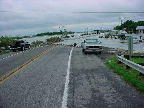
7 Maritime Services Tide and current predictions Real-time data Nowcast/Forecast Quicklook from Dauphin Island, AL


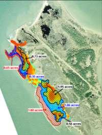
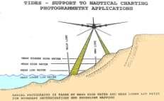
8 Mapping and Charting Support Services Chart Datum and tide control for Hydrographic/photogrammetric surveys USACE/USCG Dredging, coastal projects Vessel Traffic Systems, Automated Identification System


9 COASTAL Coastal Oceanographic Applications and Services of Tides And Lakes Program Storm Surge Tsunami


10 COASTAL Coastal Oceanographic Applications and Services of Tides And Lakes Program Habitat Restoration Climate


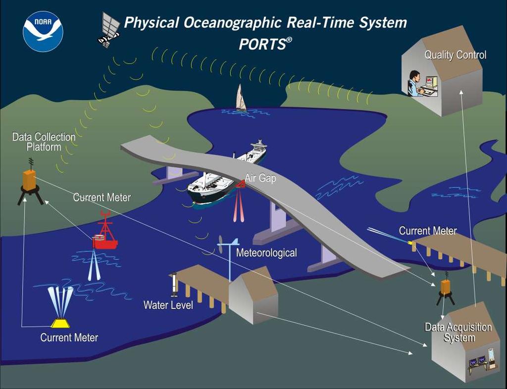
11 Observing Systems National Water Level Network (NWLON) PORTS TM Current Surveys Physical Oceanographic Real-Time System (PORTS TM )
12 Conductivity
")
13 Ports (20)
14 Maritime Safety and Efficiency Houston / Galveston, TX 60% reduction in tugs and tows groundings 50% reduction in ship groundings Tampa Bay, FL 10% reduction in recreational distress calls 50% reduction in ship groundings New York / New Jersey Over 50% reduction in ship groundings Houston Ship Channel Statistics based on economic studies by Hauke Kite-Powell, Woods Hole Oceanographic Institution

15 My PORTS My PORTS allows users to create customized PORTS pages View of currents at Sabine Neches PORTS

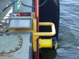
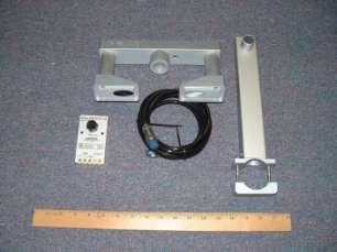
16 Technology Infusion Microwave/Water Level Sensors Miros Sutron Design Analysis Ohmart/VEGA Visibility Sensors Air Gap Laser sensors enhance quality control Waves Partnership with USACE and SCRIPPS to integrate wave buoy data into PORTS

17 CORMS Continuous Operational Real-Time Monitoring System 24-7 Quality Control- System Monitoring Operation CORMS / AI Rule-based system Performs QC and notifies Watchstanders of suspect data

18 Sea Level Rise
19 mm Global Sea Level The Global Mean Sea Level Trend From Tide Gauges & Altimetry Suggests an Acceleration Satellite altimetry ~3 mm/yr Holgate and Woodworth, mm/yr Church et al., 2006 ~1 mm/yr, Two primary causes of global sea level rise: Addition of water volume (glaciers, ice sheets, etc) Thermal expansion
20 Sea Level Rise Trends and Projections IPCC, 2001 IPCC, 2007 Global sea level during peak glacial maximum (20,000 yr ago) was >120 m lower with temps 4-7 C cooler than today Rahmstorf (Science, 2006) 2 million years ago, the average climate was about 2-3 C warmer and sea level was >25 m higher than today The Intergovernmental Panel on Climate Change (IPCC) 2007 report projects a 18 to 59 cm sea level rise from a 1.1 and 6.4 C temperature increase during the 21 st century (this projection does not consider potential contributions from accelerated ice melt in Greenland and Antarctica ).

 LOWER CHESAPEAKE BAY : Variations In Relative Annual Mean Sea Level - 1927 thru 2000 Linear Trend: +4.")
21 Elevation relative to bench mark (meters) Elevation Relative to Station Datum (meters) Local Mean Sea Level GRAND ISLE, LOUISIANA VARIATIONS IN MONTHLY AND ANNUAL MEAN SEA LEVEL Monthly Mean Sea Level Annual Mean Sea Level VARIATIONS IN MONTHLY AND ANNUAL MEAN Mean sea level is locally derived through observations at tide stations and tied to bench marks on land Relative Mean Sea Level Trend is mm/yr TIME (YEARS) LOWER CHESAPEAKE BAY : Variations In Relative Annual Mean Sea Level thru 2000 Linear Trend: +4.2mm/year Mean sea level has risen about 300mm (1 ft.) relative to the land since 1927 Local mean sea level Is dynamic and influenced by : Annual Mean Sea Level Global Sea level Astronomical Tides Seasonal To Decadal Oceanographic/Meteorological Processes Local Land Movement


22 Sea Levels Online Only source for local sea level trends in the United States Major contributor to Global Sea Level determination
23


24 Incorporating Sea Level Change Popular Island Chesapeake Bay Photo credit, USACE Incorporating sea level changes in civil works programs Incorporating sea level change into restoration guidance


25 NOAA Coastal Services Center

26 NOAA s National Ocean Service Center for Operational Oceanographic Products and Services Questions Visit the CO-OPS Website at
27 Background Slides
 Established use of ordinary low water mark as baseline for offshore submerged lands as defined and determined by Coast and Geodetic Survey.")
28 Authorization Legal Precedents 1936 Borax, Ltd v. City of Los Angeles U.S. Supreme Court case Use of 19-year tidal datum epoch concept in legal context United States v California, 332 U.S. 19, 26 (1947) Established use of ordinary low water mark as baseline for offshore submerged lands as defined and determined by Coast and Geodetic Survey. National Tidal Datum Convention of 1980 Authorized the NOAA definitions of MHW, MHHW, MLW and MLLW as the official policy of the U.S. Government. Dinkum Sands Court case


29 National Water Level Network NWLON stations


30 National Water Level Observation Network Water Level Wind Speed/Direction Barometric Pressure Air Temperature Water Temperature Conductivity


31 Maritime Services Real time data - NWLON NWLON stations are the foundation for NOAA's tide prediction products, and serve as controls in determining tidal datums for short-term waterlevel stations.


32 Maritime Services Operational forecast systems Water Level


33 COASTAL Marsh Restoration COASTAL stands for the Coastal Oceanographic Applications and Services of Tides And Lakes Program

34 Storm surge COASTAL

35 COASTAL Tsunami 1-minute water level data is collected at tsunami-capable tide stations to support national tsunami warning and mitigation efforts.
36 COASTAL Climate/SLR Mean sea level has risen about 4.4 inches relative to the land since Sea levels provide an important key to understanding the impact of climate change.

 threaten")

37 HAB Forecasts COASTAL Harmful algal blooms (HABs) threaten the health and safety of humans and marine organisms.

38 National Current Observation Program


39 High Frequency Radar
40 Annual Economic Benefits (millions) Annual PORTS Benefits From Houston/Galveston and Tampa Bay Maritime Commerce Houston/Galveston Tampa Grounding avoidance $10.5m $1.1m-2.8m Improved spill response $1.0m-3.0m $1.1m-1.8m Increased cargo $0.25m $1.1m Reduced delays $0.125m $0.01m Weather/Hazards Improved weather forecasts $2.5m-3.0m $2.0m Improved storm surge forecasts $0.5m $0.5m Recreation Enhanced beach recreation $0.12m $0.2m Enhanced recreational boating $0.62m $1.0m Enhanced recreational fishing $0.03m $0.1m TOTAL $14.8m-18.3m $6.8m-9.2m Estimated annual benefits from a National PORTS $160 million
41 Incorporating Sea Level Changes in Civil Works Programs

42 National Operational Coastal Modeling Program National network of operational hydrodynamic models providing nowcasts and short-term (0 hr. 48 hr.) forecasts Water Levels Currents Salinity Temperature

43 HAB Forecasts


44 NYOFS New York Operational Forecast System Water Level Forecast Velocity Forecast

45 Ocean Systems Test and Evaluation
Darren Wright Maritime Services Program Manager Center for Operational Oceanographic Products and Services (CO-OPS)
") Darren Wright Maritime Services Program Manager Center for Operational Oceanographic Products and Services (CO-OPS) Center for Operational Oceanographic Products and Services (CO-OPS) National Water Level
Darren Wright Maritime Services Program Manager Center for Operational Oceanographic Products and Services (CO-OPS) Center for Operational Oceanographic Products and Services (CO-OPS) National Water Level
Texas Coastal Ocean Observation Network. Richard Edwing Director, Center for Operational Oceanographic Products and Services November 2016
 Texas Coastal Ocean Observation Network Richard Edwing Director, Center for Operational Oceanographic Products and Services November 2016 What is CO-OPS? Meaningful oceanographic data for the Nation CO-OPS
Advancing Real Time Observations and Coastal Modeling Forecasts-
 Advancing Real Time Observations and Coastal Modeling Forecasts- Moving Forward in a Changing Coastal Landscape Next Generation Navigation-Coastal Operations- Coastal and Nearshore Coastal Operational
Conrad Blucher Institute for Surveying and Science
 d James Rizzo Assistant irector of Operations - Office: 361-825-5758 Mobile: 361-549-5120 james.rizzo@tamucc.edu d d Texas Coastal Ocean Observation N Network (TCOON) Began in 1988 with 2 stations in Bay
Sea Level Rise in Connecticut A Risk-Informed Approach
 GZA GeoEnvironmental, Inc. CAFM Conference October 25, 2017 Proactive By Design. Our Company Commitment Proactive By Design. Our Company Commitment Sea Level Rise in Connecticut A Risk-Informed Approach
Latest trends in sea level rise and storm surges in Maine Peter A. Slovinsky, Marine Geologist
 Latest trends in sea level rise and storm surges in Maine Peter A. Slovinsky, Marine Geologist Image from Chebeague.org Maine s glacial geology and historic sea level rise trends Current sea level trends
NOAA Nautical Charts and Coastal and Marine Spatial Planning. Meredith Westington Chief Geographer NOAA/NOS/Office of Coast Survey
 NOAA Nautical Charts and Coastal and Marine Spatial Planning Meredith Westington Chief Geographer NOAA/NOS/Office of Coast Survey Ocean Policy Task Force What is CMSP? A comprehensive, adaptive, integrated,
Sea Level Rise and the Scarborough Marsh Scarborough Land Trust Annual Meeting April 24, 2018
 Sea Level Rise and the Scarborough Marsh Scarborough Land Trust Annual Meeting April 24, 2018 Peter A. Slovinsky, Marine Geologist Maine Geological Survey Funded by: 50% 40% Figure modified from Griggs,
NOAA Inundation Dashboard
 NOAA Inundation Dashboard Audra Luscher & Paul Fanelli NOS Center for Operational Oceanographic Products & Services (CO-OPS) Hampton Roads Sea Level Rise/Flooding Adaptation Forum July 29, 2016 http://tidesandcurrents.noaa.gov/inundationdb/newyork.html
Planning for Annapolis Sea Level Rise and Future Extreme Water Levels
 Planning for Annapolis Sea Level Rise and Future Extreme Water Levels U.S. Naval Academy Sea Level Rise Advisory Council 31 October 2017 CAPT Emil Petruncio, USN (Ret.), PhD Associate Professor Gina Henderson
The Field Research Facility, Duck, NC Warming Ocean Observations and Forecast of Effects
 The Field Research Facility, Duck, NC Warming Ocean Observations and Forecast of Effects A potential consequence of a warming ocean is more frequent and more intense wind events (Hurricanes & Typhoons)
Section 145 Climate Change and Sea Level Rise
 Section 145 Climate Change and Sea Level Rise A. Definitions Rhode Island Coastal Resources Management Program 1. Climate is the long-term weather average observed within a geographic region, and climate
NOAA s Regional Climate Science & Information: Opportunities and Challenges
 NOAA s Regional Climate Science & Information: Opportunities and Challenges Dr. Wayne Higgins Climate Program Office, Director Office of Oceanic and Atmospheric Research National Oceanic and Atmospheric
Climate Change: Understanding Recent Changes in Sea Level and the Ocean. Sea Level Rise
 Climate Change: Understanding Recent Changes in Sea Level and the Ocean Sea Level Rise Philip L. Woodworth Proudman Oceanographic Laboratory, Liverpool ASE/BA/City of Culture Evening 18 October 2007 Long
Analysis of Tides and Storm Surge from Observational Records in the Delaware Inland Bays
 Analysis of Tides and Storm Surge from Observational Records in the Delaware Inland Bays John Callahan Delaware Geological Survey Coastal GeoTools Conference March 30 April 2, 2015 Charleston, SC Outline
Alaska Ocean Observing System 101 Anchorage, Alaska
 Alaska Ocean Observing System 101 Anchorage, Alaska Molly McCammon, Director Alaska Ocean Observing System (AOOS) A Regional Observing System within the Integrated Ocean Observing System www.aoos.org IOOS
Sea-level Rise on Cape Cod: How Vulnerable Are We? Rob Thieler U.S. Geological Survey Woods Hole, MA
 Sea-level Rise on Cape Cod: How Vulnerable Are We? Rob Thieler U.S. Geological Survey Woods Hole, MA Outline Sea-level and coastal processes Past sea-level change Predictions for the future Coastal responses
Turn and Face the Strange: Economic Impacts of Climate Change Sea Level Rise and Coastal Flooding E2Tech Forum June 21, 2018
 Turn and Face the Strange: Economic Impacts of Climate Change Sea Level Rise and Coastal Flooding E2Tech Forum June 21, 2018 Peter A. Slovinsky, Marine Geologist Maine Geological Survey Image from Chebeague.org
Operational Estuarine & Coastal Forecast Systems in NOAA s. National Ocean Service
 Operational Estuarine & Coastal Forecast Systems in NOAA s. National Ocean Service Eugene Wei, Frank Aikman III and Richard Patchen NOAA S S National Ocean Service Workshop on: Data Assimilation in Support
Guidance for Sea Level in 2100
 Guidance for Sea Level in 2100 Focus on Ice Melt - The Big Unknown Jim Houston 1 and Bob Dean 2 ¹ Director Emeritus, Army Engineer Research and Development Center, Corps of Engineers 2 Professor Emeritus,
Overview of NOS Coastal Ocean Operational Forecast Systems
 Overview of NOS Coastal Ocean Operational Forecast Systems Aijun Zhang NOAA/NOS Center for Operational Oceanographic Products and Services (CO-OPS) Frank Aikman III NOAA/NOS/OCS Coast Survey Development
UNDERSTANDING STORM TIDES
 UNDERSTANDING STORM TIDES Run from the water, hide from the wind.. CATEGORY CATEGORY CATEGORY CATEGORY CATEGORY 1 2 3 4 5 WIND 74-95 mph 64-82 knots 96-110 mph 83-95 knots 111-130 mph 96-113 knots 131-155
A process-based approach toward assessing the coastal impact of projected sea level rise and severe storms
 A process-based approach toward assessing the coastal impact of projected sea level rise and severe storms Patrick Barnard 1, Cheryl Hapke 2, Li Erikson 1, Amy Foxgrover 1, and Maarten van Ormondt 3 1
Climate Change Impacts in Alaska: the Weather Perspective
 Climate Change Impacts in Alaska: the Weather Perspective September 18, 2007 NOAA s National Weather Service, Alaska Region James Partain, Chief Environmental and Scientific Services Division NOAA NWS
Current and future climate of Vanuatu. Pacific-Australia Climate Change Science and Adaptation Planning Program
 Pacific-Australia Climate Change Science and Adaptation Planning Program Hiu Torres Islands Vanua Lava Gaua Banks Islands Espiritu Santo Malekula Ambae Épi Maéwo Pentecost Ambrym Shepherd Islands Éfate
Field Research Facility
 Field Research Facility Sea Level Rise Observations of Sea Level rise Forces driving change Predicting future Sea Level rise Response of land surface Storm inundation coupled with Sea Level Dr. Jesse McNinch
HURRICANE SANDY LIMITED REEVALUATION REPORT UNION BEACH, NEW JERSEY DRAFT ENGINEERING APPENDIX SUB APPENDIX C SEA LEVEL RISE ANALYSIS
 HURRICANE SANDY LIMITED REEVALUATION REPORT UNION BEACH, NEW JERSEY DRAFT ENGINEERING APPENDIX SUB APPENDIX C SEA LEVEL RISE ANALYSIS Rev. 18 Feb 2015 1.0 Introduction 1.1 Guidance The Department of the
FIG Working Week May, Bulgaria From the wisdom of the ages to the challanges of modern world
 FIG Working Week 17-21 May, Bulgaria From the wisdom of the ages to the challanges of modern world COASTAL RISK ANALYSIS OF THE BLACK SEA UNDER THE SEA LEVEL RISE N e v i n B e t u l A V S A R, S e n o
Sea Level Variability in the East Coast of Male, Maldives
 Sea Level Variability in the East Coast of Male, Maldives K.W. Indika 1 *, E.M.S. Wijerathne 2, G. W. A. R. Fernando 3, S.S.L.Hettiarachchi 4 1 National Aquatics Resources Research and Development Agency,
Physical Dynamics of the Coastal Zone in the Mediterranean on Annual to Decadal Scales
 Physical Dynamics of the Coastal Zone in the Mediterranean on Annual to Decadal Scales Hans-Peter Plag Nevada Bureau of Mines and Geology and Seismological Laboratory University of Nevada, Reno, Nevada,
The known requirements for Arctic climate services
 The known requirements for Arctic climate services based on findings described in STT White paper 8/2015 Johanna Ekman / EC PHORS STT Regional drivers The Arctic region is home to almost four million people
SEA LEVEL RISE IN THE 2017 COASTAL MASTER PLAN
 SEA LEVEL RISE IN THE 2017 COASTAL MASTER PLAN James W. Pahl, Ph.D. Coastal Resources Scientist, Senior Presentation to the Barataria-Terrebonne National Estuary Program Management Conference Meeting Nicholls
SLR: Nuisance flooding patterns along the Coastal Bend
 SLR: Nuisance flooding patterns along the Coastal Bend Philippe Tissot Conrad Blucher Institute Resilient Texas: Planning for Sea Level Rise August 8, 2017 Hurricane Ike - 9/13/2008 Marina Photos Courtesy
ASSESSING FUTURE EXPOSURE: GLOBAL AND REGIONAL SEA LEVEL RISE SCENARIOS FOR THE UNITED STATES
 ASSESSING FUTURE EXPOSURE: GLOBAL AND REGIONAL SEA LEVEL RISE SCENARIOS FOR THE UNITED STATES Chesapeake Bay Program Climate Resiliency Workgroup Conference Call May 15, 2017 William Sweet NOAA CO-OPS
Fear Over a Rising Sea is a Ruse By Dr. Jay Lehr and Tom Harris
 (EF50) DECEMBER 2018 Fear Over a Rising Sea is a Ruse By Dr. Jay Lehr and Tom Harris For the past 50 years, scientists have been studying climate change and the possibility of related sea level changes
Determining and Monitoring Sea Level in the Caribbean using
 Determining and Monitoring Sea Level in the Caribbean using Satellite Altimetry Dexter DAVIS (UWI,Trinidad & Tobago), Michael SUTHERLAND (Canada), Sandesh JAGGAN & Demi SINGH (UWI, Trinidad & Tobago) Overview
A geological perspective on sea-level rise and its impacts
 A geological perspective on sea-level rise and its impacts K.G. Miller, R.E. Kopp, B.H. Horton, J.V. Browning, A.C. Kemp Front Pages November 1, 2012 kgm@rutgers.edu Ship Bottom, Long Beach Island, NJ
: : User Manual: : - 10 December
 : : User Manual: : - 0 December 06 - : : User Manual: : Table of Contents. Map Control. How to move a map. How to zoom in and out a map 4. How to inquire Ocean Currents. How to inquire predicted current
E x a m p l e s o f t o o l s f o r s e a s i t u a t i o n a l a w a r e n e s s u s i n g C M E M S d a t a. Copernicus EU
 E x a m p l e s o f t o o l s f o r s e a s i t u a t i o n a l a w a r e n e s s u s i n g C M E M S d a t a Copernicus EU Copernicus EU Copernicus EU www.copernicus.eu S e a S i t u a t i o n a l A w
12/2/15. Providing observa.ons, data and informa.on products to meet agency and stakeholder needs
 12/2/15 Providing observa.ons, data and informa.on products to meet agency and stakeholder needs 1 Part of the Integrated Ocean Observing System (IOOS) Governed through a Memorandum of Agreement Fiscal
Preliminary Data Release for the Humboldt Bay Sea Level Rise Vulnerability Assessment: Humboldt Bay Sea Level Rise Inundation Mapping
 Preliminary Data Release for the Humboldt Bay Sea Level Rise Vulnerability Assessment: Humboldt Bay Sea Level Rise Inundation Mapping Prepared by: Jeff Anderson, Northern Hydrology & Engineering (jeff@northernhydrology.com)
Town of Old Orchard Beach: A summary of sea level rise science, storm surge, and some highlighted results from SLAWG work efforts
 Town of Old Orchard Beach: A summary of sea level rise science, storm surge, and some highlighted results from SLAWG work efforts October 15, 2013 Peter A. Slovinsky, Marine Geologist Maine Geological
Adaptation to Sea Level Rise A Regional Approach
 Adaptation to Sea Level Rise A Regional Approach Project Partners: in Saco Bay, ME Peter Slovinsky, Marine Geologist Maine Geological Survey, Department of Conservation Project Funding from: Saco Bay Hazards
North Slope Trends in Sea Level, Storm Frequency, Duration and Intensity
 North Slope Trends in Sea Level, Storm Frequency, Duration and Intensity Nels J. Sultan, Kenton W. Braun and Dempsey S. Thieman PND Engineers, Inc. Anchorage, Alaska, USA nsultan@pndengineers.com ABSTRACT
Florida Flood Risks. Heavy Rainfall. Groundwater. Tidal Flooding. Storm Surge. King Tides. Runoff/Riverine
 Florida Flood Risks Heavy Rainfall Storm Surge Groundwater Tidal Flooding Runoff/Riverine King Tides Sawgrass Mills Mall Sunrise, Florida 15 of rain in 3 days, with most in 24 hours. Mall closed for 3
Tony Pratt, DNREC to The Center for the Inland Bays Scientific and Technical Advisory Committee. August 21, 2009
 Sea Level Rise in Delaware Presented by Tony Pratt, DNREC to The Center for the Inland Bays Scientific and Technical Advisory Committee August 21, 2009 Sea level has been fluctuating ever since there have
Integrating Climate Adaptation in Hawaii Disaster Risk Management
 Integrating Climate Adaptation in Hawaii Disaster Risk Management Building Resilient Communities HCPO/HIGICC 2009 Conference September 23-25 Sheraton Waikiki Introduction What are weather/climate-related
Town of Cape Elizabeth: A summary of some of the latest sea level rise science and storm surge data to help guide municipal ordinance changes
 Town of Cape Elizabeth: A summary of some of the latest sea level rise science and storm surge data to help guide municipal ordinance changes May 29, 2014 Peter A. Slovinsky, Marine Geologist Maine Geological
THE OPEN UNIVERSITY OF SRI LANKA
 THE OPEN UNIVERSITY OF SRI LANKA Extended Abstracts Open University Research Sessions (OURS 2017) 16 th & 17 th November, 2017 The Open University of Sri Lanka - 2017 All rights reserved. No part of this
Building Marina Resilience to Storms Wisconsin Marine Association Conference November 2-3, 2016
 Julia Noordyk NOAA Great Lakes Coastal Storms Program Outreach Coordinator UW Sea Grant @NoordCoast Building Marina Resilience to Storms Wisconsin Marine Association Conference November 2-3, 2016 July
The Science of Sea Level Rise and the Impact of the Gulf Stream
 Old Dominion University ODU Digital Commons July 29, 2016: The Latest in Sea Level Rise Science Hampton Roads Sea Level Rise/Flooding Adaptation Forum 7-29-2016 The Science of Sea Level Rise and the Impact
Activity 2.2: Recognizing Change (Observation vs. Inference)
") Activity 2.2: Recognizing Change (Observation vs. Inference) Teacher Notes: Evidence for Climate Change PowerPoint Slide 1 Slide 2 Introduction Image 1 (Namib Desert, Namibia) The sun is on the horizon
Activity 2.2: Recognizing Change (Observation vs. Inference) Teacher Notes: Evidence for Climate Change PowerPoint Slide 1 Slide 2 Introduction Image 1 (Namib Desert, Namibia) The sun is on the horizon
Current and future climate of the Cook Islands. Pacific-Australia Climate Change Science and Adaptation Planning Program
 Pacific-Australia Climate Change Science and Adaptation Planning Program Penrhyn Pukapuka Nassau Suwarrow Rakahanga Manihiki N o r t h e r n C o o k I s l a nds S o u t h e Palmerston r n C o o k I s l
John Callahan (Delaware Geological Survey) Kevin Brinson, Daniel Leathers, Linden Wolf (Delaware Environmental Observing System)
 Kevin Brinson, Daniel Leathers, Linden Wolf (Delaware Environmental Observing System)") John Callahan (Delaware Geological Survey) Kevin Brinson, Daniel Leathers, Linden Wolf (Delaware Environmental Observing System) Delaware is extremely vulnerable to the impacts of coastal flooding Tropical
John Callahan (Delaware Geological Survey) Kevin Brinson, Daniel Leathers, Linden Wolf (Delaware Environmental Observing System) Delaware is extremely vulnerable to the impacts of coastal flooding Tropical
Hyperlocal Marine Weather: What s Happening?
 Hyperlocal Marine Weather: What s Happening? André van der Westhuysen 1,2 and Jeff McQueen 1 1 NOAA / National Weather Service National Centers for Environmental Prediction 2 I.M Systems Group, Rockville
Harmful Algal Bloom Detectives in the Gulf of Mexico Satellites, Gliders and Buoys, Oh My!
 Harmful Algal Bloom Detectives in the Gulf of Mexico Satellites, Gliders and Buoys, Oh My! By Chris Simoniello and Ruth Mullins* With information from: *The Gulf of Mexico Coastal Ocean Observing System
Rising Sea Levels: Time for Proactive Action in Florida and the Caribbean?
 Rising Sea Levels: Time for Proactive Action in Florida and the Caribbean? Dr. Alan Fyall and Dr. Thomas Wahl National Center for Integrated Coastal Research, University of Central Florida Dr. Roberta
Seabed 2030: A Call to Action
 Seabed 2030: A Call to Action Rear Adm. Shepard Smith NOAA Office of Coast Survey shep.smith@noaa.gov Introduction Many people like me start speeches about mapping the ocean with we know more about the
Sea Level. John Church WCRP Antarctic Climate and Ecosystems CRC Centre for Australian Weather and Climate Research
 Sea Level John Church WCRP Antarctic Climate and Ecosystems CRC Centre for Australian Weather and Climate Research Sea level rose by more than 120 m since the last glacial maximum 2 Church et al., 2008
HY-2A Satellite User s Guide
 National Satellite Ocean Application Service 2013-5-16 Document Change Record Revision Date Changed Pages/Paragraphs Edit Description i Contents 1 Introduction to HY-2 Satellite... 1 2 HY-2 satellite data
IRENE: Visitor from the Extratidal World
 IRENE: Visitor from the Extratidal World John Boon Professor Emeritus Virginia Institute of Marine Science School of Marine science College of William and Mary Hurricane Irene did not come to Hampton Roads
Impact of Sea Level Rise on Future Storm-induced Coastal Inundation
 Impact of Sea Level Rise on Future Storm-induced Coastal Inundation Changsheng Chen School for Marine Science and Technology, University of Massachusetts-Dartmouth Email: c1chen@umassd.edu 04/14/2015 Outline
NOAA s National Weather Service Philadelphia/Mt. Holly NJ
 Snow and Coastal Flooding through this evening Hazards and Impacts: Coastal Flooding: With the persistent onshore flow, and a new moon yesterday, coastal flooding is expected at high tide today. Moderate
Use of Elevation Data in NOAA Coastal Mapping Shoreline Products. Coastal GeoTools April 1, 2015
 Use of Elevation Data in NOAA Coastal Mapping Shoreline Products Coastal GeoTools April 1, 2015 - NOAA s Coastal Mapping Program & CUSP - Shoreline Uses, Delineation Issues, Definitions - Current Extraction
Design and Implementation of a NOAA/NOS Cook Inlet and Shelikof Straits Circulation Modeling System
 Design and Implementation of a NOAA/NOS Cook Inlet and Shelikof Straits Circulation Modeling System Presented at a NOAA/AEA Stakeholders Meeting, August 24, 2011, Anchorage Alaska Richard Patchen and Lyon
Peter A. Slovinsky, Marine Geologist Maine Geological Survey Department of Agriculture, Conserva=on and Forestry. Funding from:
 Peter A. Slovinsky, Marine Geologist Maine Geological Survey Department of Agriculture, Conserva=on and Forestry Funding from: 50% 40% Figure modified from Griggs, 2001 10% Global Sea Level Rise Driving
NOAA Arctic Priorities and Potential Contributions to PPP/YOPP. Randall Dole NOAA Earth System Research Laboratory Physical Sciences Division
 NOAA Arctic Priorities and Potential Contributions to PPP/YOPP Randall Dole NOAA Earth System Research Laboratory Physical Sciences Division 1 NOAA s Arctic Goals Forecast Sea Ice Strengthen Foundational
Ellen L. Mecray NOAA Regional Climate Services Director, Eastern Region Taunton, MA
 Ellen L. Mecray NOAA Regional Climate Services Director, Eastern Region Taunton, MA Regions of the US National Climate Assessment What we Observe: Climate changes and impacts Extreme precipitation and
A Perfect Storm: The Collision of Tropical Cyclones, Climate Change and Coastal Population Growth. Jeff Donnelly Woods Hole Oceanographic Institution
 A Perfect Storm: The Collision of Tropical Cyclones, Climate Change and Coastal Population Growth Jeff Donnelly Woods Hole Oceanographic Institution Recent Hurricane Trends What Might the Future Hold?
Sea-Level Rise in the Humboldt Bay Region
 Sea-Level Rise in the Humboldt Bay Region Update 1: March 2018 Prepared by Jeffrey K. Anderson Northern Hydrology & Engineering P.O. Box 2515 McKinleyville, CA 95519 Preparation of this document was partially
SAWS: Met-Ocean Data & Infrastructure in Support of Industry, Research & Public Good. South Africa-Norway Science Week, 2016
 SAWS: Met-Ocean Data & Infrastructure in Support of Industry, Research & Public Good South Africa-Norway Science Week, 2016 Marc de Vos, November 2016 South Africa: Context http://learn.mindset.co.za/sites/default/files/resourcelib/e
The Coastal Field Data Collection Program (CFDC) Waves & Coastal Observations for the Corps and the Nation
 Waves & Coastal Observations for the Corps and the Nation") The Coastal Field Data Collection Program (CFDC) Waves & Coastal Observations for the Corps and the Nation Bill Birkemeier Program Manager William.Birkemeier@usace.army.mil 10 August 2010 US Army Corps
The Coastal Field Data Collection Program (CFDC) Waves & Coastal Observations for the Corps and the Nation Bill Birkemeier Program Manager William.Birkemeier@usace.army.mil 10 August 2010 US Army Corps
Marine Spatial Data for Marine Spatial Planning. Ocean Leadership 2010 Public Policy Forum
 Marine Spatial Data for Marine Spatial Planning Ocean Leadership 2010 Public Policy Forum March 10, 2010 Edward Saade President, Fugro EarthData, Inc 1 Marine Spatial Data What is Marine Spatial Data?
Positioning the Pacific: NOAA s Geospatial Activities. Juliana Blackwell, Director NOAA s National Geodetic Survey March 6, 2012
 Positioning the Pacific: NOAA s Geospatial Activities Juliana Blackwell, Director NOAA s National Geodetic Survey March 6, 2012 A Common Problem of the Early 19 th Century 1807 President Thomas Jefferson
Sea-level change: A scientific and societal challenge for the 21 st century John Church International GNSS Service Workshop, Sydney, Feb 11, 2016
 Sea-level change: A scientific and societal challenge for the 21 st century John Church International GNSS Service Workshop, Sydney, Feb 11, 2016 OCEANS AND ATMOSPHERE NATIONAL RESEARCH FLAGSHIP Our coastal
Sea-Level Rise in the Humboldt Bay Region
 Local Sea-Level Rise (cm) Local Sea-Level Rise (cm) Sea-Level Rise in the Humboldt Bay Region Update 2: December 2018 350 300 250 200 150 North Spit Monthly Mean (1977-2016) RCP 8.5 RCP 2.6 Ext 2.5 RCP
Future Sea Level Rise and its Implications for SIDS and LDCs
 Future Sea Level Rise and its Implications for SIDS and LDCs Bill Hare, Michiel Schaeffer, Mahé Perrette, Matthias Mengel COP17, Durban, 2 nd December Overview Part 1: Global sea level: past and future
POLAR EXPLORER EXPLORING SEA LEVEL RISE
 POLAR EXPLORER EXPLORING SEA i LEVEL RISE Developed by: Margie Turrin, mkt@ldeo.columbia.edu As a polar explorer you and your team will be collec@ng evidence of changes occurring throughout the world that
GSA DATA REPOSITORY D. Livsey and A.R. Simms
 GSA DATA REPOSITORY 2013273 D. Livsey and A.R. Simms Supplementary Information The supplementary information is divided into three sections: (1) Tide model and datums, (2) Vertical error calculation, and
Sea Level Rise and Coastal Inundation Thursday 11 th October, 2012, 1.00pm, With lunch in the Legislative Council Committee Room
 The Presiding Officers invite Parliamentarians and Staff to a Science Briefing on Sea Level Rise and Coastal Inundation Thursday 11 th October, 2012, 1.00pm, With lunch in the Legislative Council Committee
HAB Forecaster. For info on HABs in the Pacific Northwest see:
 HAB Forecaster BACKGROUND In this activity, students can take on the role as a resource manager or scientist, tasked with deciding if razor clam harvesters should go out onto the beach to harvest razor
CopernicusEU. the EU's Earth Observation Programme. Sara Zennaro Atre Delegation of the European Union to Japan
 Copernicus the EU's Earth Observation Programme Sara Zennaro Atre Delegation of the European Union to Japan Status Overview, Sept 2016 & Ocean Policies Seminar 4 October 2016 ollow us on: Copernicus EU
Effects of Sea Level Decadal Variability on Acceleration and Trend Difference*
 Effects of Sea Level Decadal Variability on Acceleration and Trend Difference* James Houston 1 and Robert Dean 2 ¹ Army Engineer Research and Development Center, Corps of Engineers 2 Department of Civil
Sea Level Monitoring and the GLOSS Programme
 Sea Level Monitoring and the GLOSS Programme Philip L. Woodworth Permanent Service for Mean Sea Level Proudman Oceanographic Laboratory, UK Port Meteorological Officers Meeting, IMO, 25 July 2003 www.pol.ac.uk
Unified Sea Level Rise Projections in Practice
 Unified Sea Level Rise Projections in Practice Jayantha Obeysekera, PhD, PE, D.WRE Chief Modeler, SFWMD South Florida Hydrologic Society Meeting, January 27, 2016 Outline Unified Sea Level Rise Projections
Exploring The Polar Connection to Sea Level Rise NGSS Disciplinary Core Ideas Science & Engineering Crosscutting Concepts
 Exploring The Polar Connection to Sea Level Rise NGSS Disciplinary Core Ideas Science & Engineering Crosscutting Concepts Practices MS - ESS: Earth & Space Science 1. Ask questions 2. Developing and using
Mapping, monitoring, and modeling: USGS Coastal and Marine Geology activities along the Northeast coast
 Mapping, monitoring, and modeling: USGS Coastal and Marine Geology activities along the Northeast coast Coastal and Marine Geology Program Woods Hole Coastal and Marine Science Center St. Petersburg Coastal
Assessing the local impacts of sea level rise
 Assessing the local impacts of sea level rise Ian Miller, Coastal Hazards Specialist Washington Sea Grant MRC Conference Port Townsend, WA 5 December 2014 With contributions from: Eric Grossman, USGS;
Outline 24: The Holocene Record
 Outline 24: The Holocene Record Climate Change in the Late Cenozoic New York Harbor in an ice-free world (= Eocene sea level) Kenneth Miller, Rutgers University An Ice-Free World: eastern U.S. shoreline
Environmental Response Management Application
 Environmental Response Management Application Coastal Response Research Center Nancy Kinner, Michele Jacobi, Rob Braswell, Kurt Schwehr & Amy Merten RRT III May 14, 2008 1 Talk Outline Overview of Center
Rising Sea Level Observations and Causes. Anny Cazenave LEGOS-CNES, Toulouse, France
 Rising Sea Level Observations and Causes Anny Cazenave LEGOS-CNES, Toulouse, France AAAS Annual Meeting, Chicago, Feb.2009 Sea Level budget: Comparison between observed sea level and sum of climate contributions
Current and future climate of Vanuatu
 Hiu Torres Islands Vanua Lava Gaua Banks Islands Espiritu Santo Malekula Ambae Épi Maéwo Pentecost Ambrym Shepherd Islands Éfate PORT VILA South Pacific Ocean Erromango Tanna Aneityum Current and future
SLR Calculator: Sea Level Rise (SLR) Inundation Surface Calculator Add-in for ArcGIS Desktop & 10.4
 Inundation Surface Calculator Add-in for ArcGIS Desktop & 10.4") 1 SLR Calculator: Sea Level Rise (SLR) Inundation Surface Calculator Add-in for ArcGIS Desktop 10.3.1 & 10.4 Florida Sea Level Scenario Sketch Planning Tool Version 1.6, July 2016 University of Florida
1 SLR Calculator: Sea Level Rise (SLR) Inundation Surface Calculator Add-in for ArcGIS Desktop 10.3.1 & 10.4 Florida Sea Level Scenario Sketch Planning Tool Version 1.6, July 2016 University of Florida
Climate Change in Newfoundland & Labrador
 Climate Change in Newfoundland & Labrador Impacts and Adaptation Newleef Conference 08 October 2015 Met-Ocean Services The Team 55 personnel; 24/7 operational weather forecast desk; Equipment technician
Hurricanes in a Warming World. Jeff Donnelly Woods Hole Oceanographic Institution
 Hurricanes in a Warming World Jeff Donnelly Woods Hole Oceanographic Institution Hurricanes impacting the NE US Hurricane Sandy Was Hurricane Sandy a freak of nature? Or had we just been lucky? What are
SECTION 13: SEA LEVEL RISE ADAPTATION
 Appropriate quote here. SECTION 13: SEA LEVEL RISE ADAPTATION 1. Statement of State and Local Goals. A. State Goals: There are currently no State goals related to sea level rise. B. Local Goals: 1. TBD
Should I Sell My Shore House? NJ As a Natural Laboratory for Sea-level Change Ken Miller, Chair of Geological Sciences (FAS)
") Should I Sell My Shore House? NJ As a Natural Laboratory for Sea-level Change Ken Miller, Chair of Geological Sciences (FAS) Hurricane Isabelle, Avalon, NJ 9/18/2003 December Nor easter, LBI, 12/1993 Ash
Should I Sell My Shore House? NJ As a Natural Laboratory for Sea-level Change Ken Miller, Chair of Geological Sciences (FAS) Hurricane Isabelle, Avalon, NJ 9/18/2003 December Nor easter, LBI, 12/1993 Ash
Regional-scale understanding of the geologic character and sand resources of the Atlantic inner continental shelf, Maine to Virginia
 Regional-scale understanding of the geologic character and sand resources of the Atlantic inner continental shelf, Maine to Virginia Workshop on Dredging, Beach Nourishment and Bird Conservation Atlantic
BOEM Marine Minerals Program
 BOEM Marine Minerals Program Restoring and Protecting Our Nation s Coasts through Stewardship of OCS Sand Resources SECOORA 2018 Annual Meeting May 22-24 Doug Piatkowski Douglas.piatkowski@boem.gov 703-787-1833
Arctic. Ocean Observing Build Out Plan. alaska ocean observing system. March 1, 2013 draft. Tom Van Pelt
 Arctic Ocean Observing Build Out Plan March 1, 2013 draft Tom Van Pelt alaska ocean observing system Tom Van Pelt Why a coastal observing system in the Arctic? The Arctic is booming with increased activity