Planning for Annapolis Sea Level Rise and Future Extreme Water Levels
|
|
|
- Clement Wells
- 5 years ago
- Views:
Transcription
, PhD Associate Professor Gina Henderson Photo Credit: https://marinas.com")
1 Planning for Annapolis Sea Level Rise and Future Extreme Water Levels U.S. Naval Academy Sea Level Rise Advisory Council 31 October 2017 CAPT Emil Petruncio, USN (Ret.), PhD Associate Professor Gina Henderson Photo Credit:

2 The U.S. Naval Academy is a 338 acre National Historic Landmark. Photo: Forbes Images


3 The buildings, monuments, and traditions of the U.S. Naval Academy preserve and promote the core values of the Navy and Marine Corps: Honor, Courage, and Commitment.
4 Naval Academy Sea Level Rise Advisory Council Constituted in July 2015 by direction of the Superintendent of the Naval Academy Mission: Develop a Sea Level Adaptation Plan for the Superintendent on matters pertaining to flooding due to sea level rise and severe weather events in the Annapolis area. This plan, developed in coordination with the City of Annapolis, the State of Maryland and key federal agencies, will suggest a path forward for planning for the impacts of sea level rise on the Naval Academy through Specific focus: impacts to operational requirements of the Naval Academy, including the USNA lower yard, upper yard and the federal property on North Severn.
5 Elevation (Feet) Relative to MLLW 8 Annapolis Hourly Sea Level Data for 1933 and 2003 Referenced to Mean Lower Low Water Dashed line indicates level of minor flooding at Annapolis City Dock (2.38 ft above MLLW) 6 4 Cumulative Hours of Flooding minor moderate 1933: : Chesapeake Potomac Hurricane Hurricane Isabel Avg = 0.86 ft 1933 Avg = 0.11 ft -4 Both years featured major flooding events due to storm surge, but average sea level in 2003 was 0.75 feet (9 inches) higher than in 1933, resulting in broader areal flooding for extreme events and much more frequent occurrences of minor flooding. According to NOAA (Sweet and Park, 2014), the number of nuisance flood days for Annapolis has increased from 3 per year during to 34 per year during
 Nuisance Flooding at Annapolis City Dock (NWS Minor Threshold = MLLW + 2.")
6 Water Level Relative to MLLW (feet) Nuisance flooding events in Annapolis have increased significantly in the past several decades, and are more frequent during Mid-Spring to Mid-Autumn due to warmer surface waters and thermal expansion. Nuisance Flooding at USNA (MLLW ft) Nuisance Flooding at Annapolis City Dock (NWS Minor Threshold = MLLW ft) MHHW MHW MSL MLLW Annapolis Hourly Water Levels 15 April 15 October 2014
 2013 IPCC Assessment")

, UCS Report on 18 Military Installations, Military Expert Panel")
7 Recent Sea Level Studies 2012 NRC Report on MSLR Processes, NOAA Sea Level Rise Scenarios for National Climate Assessment (NCA) 2013 IPCC Assessment Report 5 (AR5), MD Update of 2008 Assessment, Updated USACE Guidance 2014 National Climate Assessment 2016 DoD-led, Multi-Agency Report on Regional Scenarios (Hall et al., 2016), UCS Report on 18 Military Installations, Military Expert Panel Report on SLR 2017 NOAA Global and Regional SLR Scenarios for the U.S.
8 Sea Level Relative to MSL in 1992 (ft) Relative Sea Level Rise Scenarios for Annapolis from Hall et al. (2016) and Sweet et al. (2017) with Annapolis Monthly Mean Sea Level Data for Extreme (2.5m) High (2.0m) Intermediate High (1.5m) Intermediate (1.0m) Intermediate Low (0.5m) Low (0.3m) High Emission Scenario with Max Contribution from Ice Sheets Moderate to High Emissions Low Emissions; Major Carbon Cuts and Carbon Removal The six Global Mean Sea Level (GMSL) scenarios in Sweet et al., 2017, identified by the height in meters in 2100 relative to MSL in 2000, span the range of scientifically plausible sea level rise scenarios. The shaded regions represent a central 80% probability range for each scenario. These curves have been adjusted to depict MSL relative to The five scenarios described in Hall et al., 2016 correspond to GMSL of 2.0m, 1.5m, 1.0m, 0.5m, and 0.2m relative to MSL in 1992, and are indicated by thick black lines Year Graphic by E.T. Petruncio

9 During the Holocene Epoch, the rate of sea level rise has varied between still stands and periods of rapid rise (several meters per century), resulting in submerged marine terraces. The rapid rates of sea level rise indicate that ice shelves can break up rapidly. MWP = Melt Water Pulse Graphics courtesy of Ocean Exploration Trust and Liu et al., 2004, Holocene development of the Yellow River s subaqueous delta, North Yellow Sea. Marine Geology, 209(1-4): 45-67
10 Feet Above Mean Sea Level Hall et al. (2016) Annapolis Sea Level Rise Scenarios Referenced to MSL for (MSL = 0 in 1992) Note: Increases in MSL may not be as smooth as depicted, especially for highest scenario (when most SLR would occur beyond 2070) Isabel Hospital Point, Dewey Field, Gate 1 Mid Store Lot, NW End Holloway Rd Waffle Lot Ramsay Rd, McNair Rd, City Dock An average high tide (Mean High Water) will add 0.47 ft to these values twice daily. For short range forecasts (2035 and earlier), interannual variability (+/- 4 inches) may be more significant than changes due to long term sea level rise.

11 College Creek Severn River Spa Creek
12 4 ft Above Mean Higher High Water (4.71 feet above MSL) (Mid Store Lot, Brownson Rd, 8 th Wing Lot, Gate 1 area) 2.5m: m: m: m: 2096 Dates at which MSL reaches this level for various scenarios Datum: Mean Higher High Water (.71 feet above MSL) Graphic courtesy of Climate Central
13

14 Extreme Events Hurricane Isabel 19 Sep hours (5 inches) prior to peak water level

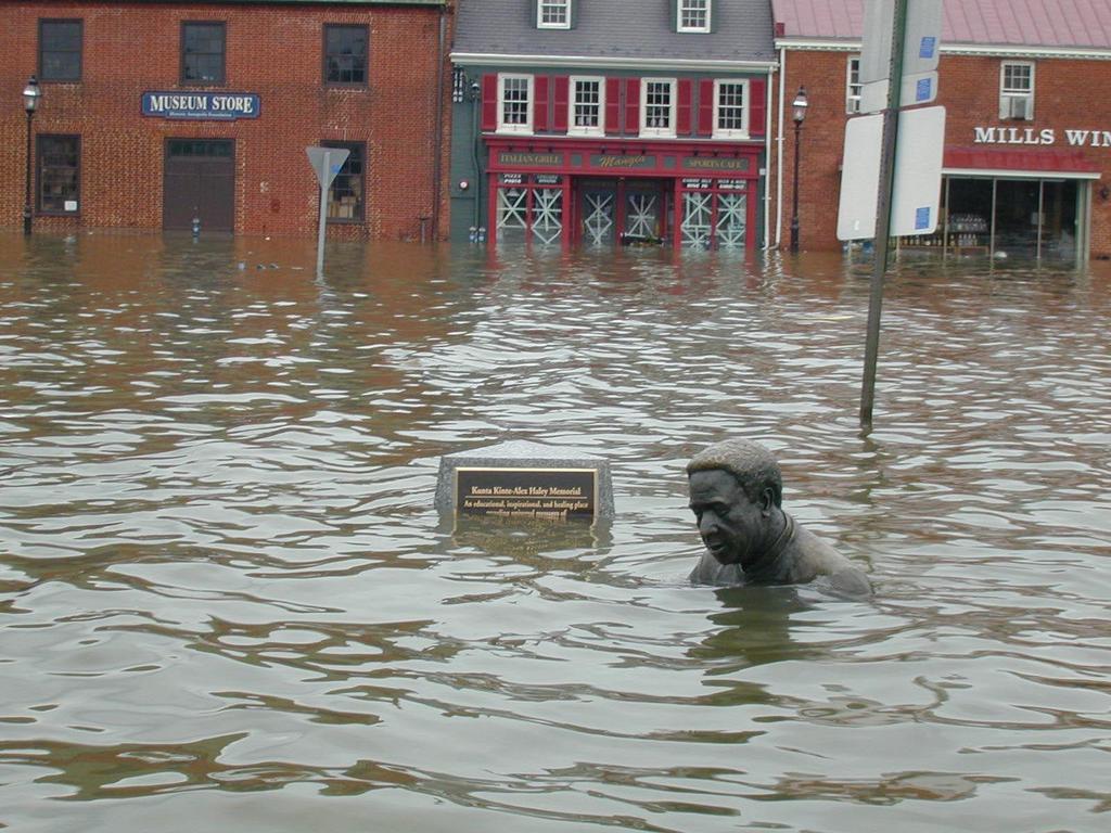
15 Inundation of the U.S. Naval Academy after Hurricane Isabel

16 6 ft Above Mean Higher High Water (6.71 feet above MSL) (Hurricane Isabel) 2.5m: m: m: 2096 Date at which MSL reaches this level for the highest scenario Datum: Mean Higher High Water (.71 feet above MSL) Graphic courtesy of Climate Central
17 Sea Level Relative to MSL in 1992 (ft) Annapolis Historical Sea Level, Scenario for a 1.0m rise in Global Mean Sea Level and Extreme Water Levels based on Hall et al., Extreme Water Levels (ft) for 1.0m GMSL Scenario (Hall et al., 2016) Flooding Event % / 5 Year % / 20 Year % / 50 Year % / 100 year 7 1% /100 Year % / 50 year Isabel 6 5 5% / 20 year 20% / 5 year Hospital Pt, Dewey Fld, Gate Adjustment for MHHW Midstore Lot Waffle Lot 2 Ramsay Rd, McNair Rd, City Dock Year
18 Summary Uncertainties in future Sea Level Rise (SLR) include climate forcings (cloud cover, aerosols, etc.), physical system response (Antarctic ice shelves and glaciers, etc.), and human behavior (future greenhouse gas emissions). We should deal with these uncertainties by considering a range of SLR scenarios and risk tolerances for various projects. Range of plausible SLR scenarios for Annapolis, relative to Mean Sea Level (MSL) (MSL = 0 in 1992): Hall et al. (2016) Sweet et al. (2017) ft ft ft ft Under a conservative SLR scenario (1m / 3.28 ft rise in Global MSL by 2100), nuisance flooding at USNA will occur daily during the summer months beginning around Flooding due to storm surge will be exacerbated by SLR. Most scenarios considered by Hall et al. (2016) show Hurricane Isabel-like water levels becoming a 1 in 20 year event by 2065 and a 1 in 5 year event by the end of the century. These projections are based on historical storm statistics, and assume no changes in storm frequency or intensity.
19
20 Diving Deeper


21 The Northern Channel Islands were connected during the last glacial maximum, when sea level was approximately 120m lower. As sea level rose, wave action shaped marine terraces. San Miguel Santa Rosa Santa Cruz Marine Terraces Anacapa
22 Meters Meters Comparison of Mean Sea Level Trend in Annapolis Tide Gauge Data to Highest and Lowest Scenarios in Hall et al. (2016) As of 2015, the rate of sea level rise in Annapolis was / mm/yr m (2.6 ft) 0.2m (0.7 ft) 20 The lower bound for sea level rise scenarios should be based on historical trends dating back at least 50 years, as shorter record lengths (such as satellite altimetry measurements) may be affected by interannual / decadal variability. A plausible range of sea level rise in Annapolis by 2050 is from 0.2 m (0.7 ft) to 0.8m (2.6 ft), relative to Mean Sea Level for the current tidal epoch ( ) (Hall et al., 2016)

23 Based on Figure 5 from Alexander Nauels et al 2017 Environ. Res. Lett doi: / /aa92b6
24 Combined Sea Level Rise and Extreme Water Level Values (Hall et al., 2016) Base Unit: Feet, Referenced to Mean Sea Level (add 0.05 for NAVD88) These projections assume stationarity of historical storm statistics 20% / 5 Year Event 5% / 20 Year Event Scenario Lowest Low Medium High Highest Scenario Lowest Low Medium High Highest Scenario Lowest Low Medium High Highest % / 50 Year Event 1% / 100 Year Event Scenario Lowest Low Medium High Highest
Sea Level Rise in Connecticut A Risk-Informed Approach
 GZA GeoEnvironmental, Inc. CAFM Conference October 25, 2017 Proactive By Design. Our Company Commitment Proactive By Design. Our Company Commitment Sea Level Rise in Connecticut A Risk-Informed Approach
Latest trends in sea level rise and storm surges in Maine Peter A. Slovinsky, Marine Geologist
 Latest trends in sea level rise and storm surges in Maine Peter A. Slovinsky, Marine Geologist Image from Chebeague.org Maine s glacial geology and historic sea level rise trends Current sea level trends
ASSESSING FUTURE EXPOSURE: GLOBAL AND REGIONAL SEA LEVEL RISE SCENARIOS FOR THE UNITED STATES
 ASSESSING FUTURE EXPOSURE: GLOBAL AND REGIONAL SEA LEVEL RISE SCENARIOS FOR THE UNITED STATES Chesapeake Bay Program Climate Resiliency Workgroup Conference Call May 15, 2017 William Sweet NOAA CO-OPS
Analysis of Tides and Storm Surge from Observational Records in the Delaware Inland Bays
 Analysis of Tides and Storm Surge from Observational Records in the Delaware Inland Bays John Callahan Delaware Geological Survey Coastal GeoTools Conference March 30 April 2, 2015 Charleston, SC Outline
A Tutorial on Climate Change Science: The. 4 th National Climate Assessment CLIMATE SCIENCE. Don Wuebbles
 CLIMATE SCIENCE S P E C I A L R E P O R T A Tutorial on Climate Change Science: The Fourth National Climate Assessment Volume I 4 th National Climate Assessment Don Wuebbles Department of Atmospheric Sciences
NOAA s National Ocean Service. Center for Operational Oceanographic Products and Services
 NOAA s National Ocean Service Center for Operational Oceanographic Products and Services Richard Edwing, CO-OPS Acting Director January 27, 2010 Outline CO-OPS Overview Programs Observing Systems PORTS
Climate Adaptation Challenges for Boston s Water and Sewer Systems
 National Association of Flood & Stormwater Management Agencies Climate Adaptation Challenges for Boston s Water and Sewer Systems John P Sullivan P.E. October 15,2014 Boston 1630 Boston 1630-2012 Boston
Crystal Goodison & Alexis Thomas University of Florida GeoPlan Center
 Crystal Goodison & Alexis Thomas University of Florida GeoPlan Center A1A Fort Lauderdale, Hurricane Sandy, October 2012 Photo Credits: Susan Stocker, Sun Sentinel FAU s Research Report (completed Jan
SLR: Nuisance flooding patterns along the Coastal Bend
 SLR: Nuisance flooding patterns along the Coastal Bend Philippe Tissot Conrad Blucher Institute Resilient Texas: Planning for Sea Level Rise August 8, 2017 Hurricane Ike - 9/13/2008 Marina Photos Courtesy
The Science of Sea Level Rise and the Impact of the Gulf Stream
 Old Dominion University ODU Digital Commons July 29, 2016: The Latest in Sea Level Rise Science Hampton Roads Sea Level Rise/Flooding Adaptation Forum 7-29-2016 The Science of Sea Level Rise and the Impact
Assessing the local impacts of sea level rise
 Assessing the local impacts of sea level rise Ian Miller, Coastal Hazards Specialist Washington Sea Grant MRC Conference Port Townsend, WA 5 December 2014 With contributions from: Eric Grossman, USGS;
Beyond 2100: Committed Sea Level Rise in South Florida Produced by 21st Century Global Temperature Rise
 Beyond 2100: Committed Sea in South Florida Produced by 21st Century Global Temperature Rise Presented by: Pete Harlem Presented at GIS Day November 6, Pete Harlem, Jack Meeder and Randy Parkinson It s
Town of Old Orchard Beach: A summary of sea level rise science, storm surge, and some highlighted results from SLAWG work efforts
 Town of Old Orchard Beach: A summary of sea level rise science, storm surge, and some highlighted results from SLAWG work efforts October 15, 2013 Peter A. Slovinsky, Marine Geologist Maine Geological
Sea Level Rise Study Summary Town of South Bethany
 Sea Level Rise Study Summary Town of South Bethany This presentation was prepared by Anchor QEA for the Town of South Bethany using Federal Funds under award NA14 NOS 419 0123 from the Delaware Coastal
Integrating Climate Adaptation in Hawaii Disaster Risk Management
 Integrating Climate Adaptation in Hawaii Disaster Risk Management Building Resilient Communities HCPO/HIGICC 2009 Conference September 23-25 Sheraton Waikiki Introduction What are weather/climate-related
IRENE: Visitor from the Extratidal World
 IRENE: Visitor from the Extratidal World John Boon Professor Emeritus Virginia Institute of Marine Science School of Marine science College of William and Mary Hurricane Irene did not come to Hampton Roads
NOAA Inundation Dashboard
 NOAA Inundation Dashboard Audra Luscher & Paul Fanelli NOS Center for Operational Oceanographic Products & Services (CO-OPS) Hampton Roads Sea Level Rise/Flooding Adaptation Forum July 29, 2016 http://tidesandcurrents.noaa.gov/inundationdb/newyork.html
UNDERSTANDING STORM TIDES
 UNDERSTANDING STORM TIDES Run from the water, hide from the wind.. CATEGORY CATEGORY CATEGORY CATEGORY CATEGORY 1 2 3 4 5 WIND 74-95 mph 64-82 knots 96-110 mph 83-95 knots 111-130 mph 96-113 knots 131-155
Activity 2.2: Recognizing Change (Observation vs. Inference)
") Activity 2.2: Recognizing Change (Observation vs. Inference) Teacher Notes: Evidence for Climate Change PowerPoint Slide 1 Slide 2 Introduction Image 1 (Namib Desert, Namibia) The sun is on the horizon
Activity 2.2: Recognizing Change (Observation vs. Inference) Teacher Notes: Evidence for Climate Change PowerPoint Slide 1 Slide 2 Introduction Image 1 (Namib Desert, Namibia) The sun is on the horizon
Tony Pratt, DNREC to The Center for the Inland Bays Scientific and Technical Advisory Committee. August 21, 2009
 Sea Level Rise in Delaware Presented by Tony Pratt, DNREC to The Center for the Inland Bays Scientific and Technical Advisory Committee August 21, 2009 Sea level has been fluctuating ever since there have
Turn and Face the Strange: Economic Impacts of Climate Change Sea Level Rise and Coastal Flooding E2Tech Forum June 21, 2018
 Turn and Face the Strange: Economic Impacts of Climate Change Sea Level Rise and Coastal Flooding E2Tech Forum June 21, 2018 Peter A. Slovinsky, Marine Geologist Maine Geological Survey Image from Chebeague.org
CLIMATE READY BOSTON. Climate Projections Consensus ADAPTED FROM THE BOSTON RESEARCH ADVISORY GROUP REPORT MAY 2016
 CLIMATE READY BOSTON Sasaki Steering Committee Meeting, March 28 nd, 2016 Climate Projections Consensus ADAPTED FROM THE BOSTON RESEARCH ADVISORY GROUP REPORT MAY 2016 WHAT S IN STORE FOR BOSTON S CLIMATE?
Adaptation to Sea Level Rise A Regional Approach
 Adaptation to Sea Level Rise A Regional Approach Project Partners: in Saco Bay, ME Peter Slovinsky, Marine Geologist Maine Geological Survey, Department of Conservation Project Funding from: Saco Bay Hazards
Preliminary Vulnerability Assessment of Coastal Flooding Threats - Taylor County, Florida
 Preliminary Vulnerability Assessment of Coastal Flooding Threats - Taylor County, Florida North Central Florida Regional Planning Council Northeast Florida Regional Council April 28, 2016 BACKGROUND This
South Florida Storm Surge
 South Florida Storm Surge Highest storm tide Everglades City/Chokoloskee in area closest to landfall Nevertheless, storm tide as high as 6 feet along Biscayne Bay about 90 miles from eye of Irma! Closer
Hurricanes, Sea Level Rise, and South Florida s Challenging Future
 Hurricanes, Sea Level Rise, and South Florida s Challenging Future Brian McNoldy Senior Research Associate University of Miami Tropical Weather Expert Washington Post Scientific Advisor Coastal Risk Consulting
Sea-level Rise Projections
 Updating Maryland s Sea-level Rise Projections Scientific and Technical Working Group Maryland Climate Change Commission June 26, 2013 1 5 8 16 18 Table of contents Introduction 1 Sea-level Rise and the
A geological perspective on sea-level rise and its impacts
 A geological perspective on sea-level rise and its impacts K.G. Miller, R.E. Kopp, B.H. Horton, J.V. Browning, A.C. Kemp Front Pages November 1, 2012 kgm@rutgers.edu Ship Bottom, Long Beach Island, NJ
Town of Cape Elizabeth: A summary of some of the latest sea level rise science and storm surge data to help guide municipal ordinance changes
 Town of Cape Elizabeth: A summary of some of the latest sea level rise science and storm surge data to help guide municipal ordinance changes May 29, 2014 Peter A. Slovinsky, Marine Geologist Maine Geological
Sea-Level Rise in the Humboldt Bay Region
 Sea-Level Rise in the Humboldt Bay Region Update 1: March 2018 Prepared by Jeffrey K. Anderson Northern Hydrology & Engineering P.O. Box 2515 McKinleyville, CA 95519 Preparation of this document was partially
Unified Sea Level Rise Projections in Practice
 Unified Sea Level Rise Projections in Practice Jayantha Obeysekera, PhD, PE, D.WRE Chief Modeler, SFWMD South Florida Hydrologic Society Meeting, January 27, 2016 Outline Unified Sea Level Rise Projections
Section 145 Climate Change and Sea Level Rise
 Section 145 Climate Change and Sea Level Rise A. Definitions Rhode Island Coastal Resources Management Program 1. Climate is the long-term weather average observed within a geographic region, and climate
Sea-Level Rise in the Humboldt Bay Region
 Local Sea-Level Rise (cm) Local Sea-Level Rise (cm) Sea-Level Rise in the Humboldt Bay Region Update 2: December 2018 350 300 250 200 150 North Spit Monthly Mean (1977-2016) RCP 8.5 RCP 2.6 Ext 2.5 RCP
SEA LEVEL RISE IN THE 2017 COASTAL MASTER PLAN
 SEA LEVEL RISE IN THE 2017 COASTAL MASTER PLAN James W. Pahl, Ph.D. Coastal Resources Scientist, Senior Presentation to the Barataria-Terrebonne National Estuary Program Management Conference Meeting Nicholls
What is Climate? Climate Change Evidence & Causes. Is the Climate Changing? Is the Climate Changing? Is the Climate Changing? Is the Climate Changing?
 What is Climate? 1 Climate Change Evidence & Causes Refers to the average environmental conditions (i.e. temperature, precipitation, extreme events) in a given location over many years Climate is what
Sea Level Rise and the Scarborough Marsh Scarborough Land Trust Annual Meeting April 24, 2018
 Sea Level Rise and the Scarborough Marsh Scarborough Land Trust Annual Meeting April 24, 2018 Peter A. Slovinsky, Marine Geologist Maine Geological Survey Funded by: 50% 40% Figure modified from Griggs,
Florida Flood Risks. Heavy Rainfall. Groundwater. Tidal Flooding. Storm Surge. King Tides. Runoff/Riverine
 Florida Flood Risks Heavy Rainfall Storm Surge Groundwater Tidal Flooding Runoff/Riverine King Tides Sawgrass Mills Mall Sunrise, Florida 15 of rain in 3 days, with most in 24 hours. Mall closed for 3
Projected Impacts of Climate Change in Southern California and the Western U.S.
 Projected Impacts of Climate Change in Southern California and the Western U.S. Sam Iacobellis and Dan Cayan Scripps Institution of Oceanography University of California, San Diego Sponsors: NOAA RISA
Current and future climate of the Cook Islands. Pacific-Australia Climate Change Science and Adaptation Planning Program
 Pacific-Australia Climate Change Science and Adaptation Planning Program Penrhyn Pukapuka Nassau Suwarrow Rakahanga Manihiki N o r t h e r n C o o k I s l a nds S o u t h e Palmerston r n C o o k I s l
Climate Change: Impacts, Solutions, and Perceptions (part 2) OLLI, Spring 2013
 OLLI, Spring 2013") Climate Change: Impacts, Solutions, and Perceptions (part 2) OLLI, Spring 2013 Climate Change: Impacts, Solutions, and Perceptions Spring 2013 (part 2) February 19 Ocean acidification and the increase
Climate Change: Impacts, Solutions, and Perceptions (part 2) OLLI, Spring 2013 Climate Change: Impacts, Solutions, and Perceptions Spring 2013 (part 2) February 19 Ocean acidification and the increase
Sea-level change: A scientific and societal challenge for the 21 st century John Church International GNSS Service Workshop, Sydney, Feb 11, 2016
 Sea-level change: A scientific and societal challenge for the 21 st century John Church International GNSS Service Workshop, Sydney, Feb 11, 2016 OCEANS AND ATMOSPHERE NATIONAL RESEARCH FLAGSHIP Our coastal
Field Research Facility
 Field Research Facility Sea Level Rise Observations of Sea Level rise Forces driving change Predicting future Sea Level rise Response of land surface Storm inundation coupled with Sea Level Dr. Jesse McNinch
Climate change: How do we know?
 Climate change: How do we know? This graph, based on the comparison of atmospheric samples contained in ice cores and more recent direct measurements, provides evidence that atmospheric CO2 has increased
Update on Climate Science. Professor Richard Betts, Met Office
 Update on Climate Science Professor Richard Betts, Met Office The science of climate change Crown copyright Met Office Prof Richard Betts Head of Climate Impacts Research Crown copyright Met Office Observing
Current Climate Science and Climate Scenarios for Florida
 Current Climate Science and Climate Scenarios for Florida Daniel Bader and Vivien Gornitz Water Utilities and Climate Change Workshop Palm Beach County Water Utilities/ Water Research Foundation June 10,
Peter A. Slovinsky, Marine Geologist Maine Geological Survey Department of Agriculture, Conserva=on and Forestry. Funding from:
 Peter A. Slovinsky, Marine Geologist Maine Geological Survey Department of Agriculture, Conserva=on and Forestry Funding from: 50% 40% Figure modified from Griggs, 2001 10% Global Sea Level Rise Driving
Sea-level Rise on Cape Cod: How Vulnerable Are We? Rob Thieler U.S. Geological Survey Woods Hole, MA
 Sea-level Rise on Cape Cod: How Vulnerable Are We? Rob Thieler U.S. Geological Survey Woods Hole, MA Outline Sea-level and coastal processes Past sea-level change Predictions for the future Coastal responses
Building Marina Resilience to Storms Wisconsin Marine Association Conference November 2-3, 2016
 Julia Noordyk NOAA Great Lakes Coastal Storms Program Outreach Coordinator UW Sea Grant @NoordCoast Building Marina Resilience to Storms Wisconsin Marine Association Conference November 2-3, 2016 July
HURRICANE SANDY LIMITED REEVALUATION REPORT UNION BEACH, NEW JERSEY DRAFT ENGINEERING APPENDIX SUB APPENDIX C SEA LEVEL RISE ANALYSIS
 HURRICANE SANDY LIMITED REEVALUATION REPORT UNION BEACH, NEW JERSEY DRAFT ENGINEERING APPENDIX SUB APPENDIX C SEA LEVEL RISE ANALYSIS Rev. 18 Feb 2015 1.0 Introduction 1.1 Guidance The Department of the
A process-based approach toward assessing the coastal impact of projected sea level rise and severe storms
 A process-based approach toward assessing the coastal impact of projected sea level rise and severe storms Patrick Barnard 1, Cheryl Hapke 2, Li Erikson 1, Amy Foxgrover 1, and Maarten van Ormondt 3 1
Three main areas of work:
 Task 2: Climate Information 1 Task 2: Climate Information Three main areas of work: Collect historical and projected weather and climate data Conduct storm surge and wave modeling, sea-level rise (SLR)
Sea level change around the Philippines
 Sea level Sea level around the Philippines Institute of Environmental Science for Social Change (ESSC) Conference on Internal Migration and Displacement Davao City, Philippines 20 May 2012 Regional How
LONDON & TE December 2009
 LONDON & TE2100 10 December 2009 Tim Reeder Environment Agency How is London vulnerable to CC? Flooding Overheating Water resources Air Quality Subsidence and heave Wind storms Global climate events What
The Field Research Facility, Duck, NC Warming Ocean Observations and Forecast of Effects
 The Field Research Facility, Duck, NC Warming Ocean Observations and Forecast of Effects A potential consequence of a warming ocean is more frequent and more intense wind events (Hurricanes & Typhoons)
SLR Calculator: Sea Level Rise (SLR) Inundation Surface Calculator Add-in for ArcGIS Desktop & 10.4
 Inundation Surface Calculator Add-in for ArcGIS Desktop & 10.4") 1 SLR Calculator: Sea Level Rise (SLR) Inundation Surface Calculator Add-in for ArcGIS Desktop 10.3.1 & 10.4 Florida Sea Level Scenario Sketch Planning Tool Version 1.6, July 2016 University of Florida
1 SLR Calculator: Sea Level Rise (SLR) Inundation Surface Calculator Add-in for ArcGIS Desktop 10.3.1 & 10.4 Florida Sea Level Scenario Sketch Planning Tool Version 1.6, July 2016 University of Florida
Sea Level. John Church WCRP Antarctic Climate and Ecosystems CRC Centre for Australian Weather and Climate Research
 Sea Level John Church WCRP Antarctic Climate and Ecosystems CRC Centre for Australian Weather and Climate Research Sea level rose by more than 120 m since the last glacial maximum 2 Church et al., 2008
BECQ 2017 SLR Map Layer Updates: Methodology for Coastal Flood Geoprocessing
 BECQ 2017 SLR Map Layer Updates: Methodology for Coastal Flood Geoprocessing This paper summarizes the local and regional sea level data used to develop coastal flooding scenarios for the island of Saipan,
Characterizing changes in storm surges and flood risk in the presence of sea level rise: statistical approaches and challenges
 Characterizing changes in storm surges and flood risk in the presence of sea level rise: statistical approaches and challenges Claudia Tebaldi Climate and Global Dynamics Division NCAR tebaldi@ucar.edu
Appendix 1: UK climate projections
 Appendix 1: UK climate projections The UK Climate Projections 2009 provide the most up-to-date estimates of how the climate may change over the next 100 years. They are an invaluable source of information
RAPID STEPS OF SEA LEVEL RISE: An Ominous View Into the Future
 RAPI STEPS OF SEA LEVEL RISE: An Ominous View Into the Future http://sedac.ciesin.columbia.edu/gpw/lecz.jsp Harold R. Wanless epartment of Geological Sciences University of Miami hwanless@miami.edu Society
Preliminary Data Release for the Humboldt Bay Sea Level Rise Vulnerability Assessment: Humboldt Bay Sea Level Rise Inundation Mapping
 Preliminary Data Release for the Humboldt Bay Sea Level Rise Vulnerability Assessment: Humboldt Bay Sea Level Rise Inundation Mapping Prepared by: Jeff Anderson, Northern Hydrology & Engineering (jeff@northernhydrology.com)
2017 State of U.S. High Tide Flooding with a 2018 Outlook
 2017 State of U.S. High Tide Flooding with a 2018 Outlook William V. Sweet 1, Doug Marcy 2, Gregory Dusek 1, John J. Marra 3, Matt Pendleton 4 National Oceanic and Atmospheric Administration (NOAA) Center
CLIMATE MODEL DOWNSCALING: HOW DOES IT WORK AND WHAT DOES IT TELL YOU?
 rhgfdjhngngfmhgmghmghjmghfmf CLIMATE MODEL DOWNSCALING: HOW DOES IT WORK AND WHAT DOES IT TELL YOU? YAN FENG, PH.D. Atmospheric and Climate Scientist Environmental Sciences Division Argonne National Laboratory
Potential Impacts of Climate Change on the Interstate Highway System
 Potential Impacts of Climate Change on the Interstate Highway System Don Wuebbles Jennifer Jacobs TRB, Chicago July 12, 2017 Date Name of Meeting 1 Introduction The U.S. Interstate Highway System is vital
Background and Purpose of Meeting. River Towers Meeting. Flood Risk Management Study Alternatives Overview
 1 and Purpose of Meeting River Towers Meeting Flood Risk Management Study Alternatives Overview September 23, 2014 There is no "proposed" flood risk management solution for this area at this time Fairfax
Chapter 2. Changes in Sea Level Melting Cryosphere Atmospheric Changes Summary IPCC (2013)
") IPCC (2013) Ice is melting faster (sea ice, glaciers, ice sheets, snow) Sea level is rising More ocean heat content More intense rainfall More severe drought Fewer frosts More heat waves Spring is arriving
IPCC (2013) Ice is melting faster (sea ice, glaciers, ice sheets, snow) Sea level is rising More ocean heat content More intense rainfall More severe drought Fewer frosts More heat waves Spring is arriving
Great Lakes Update. Volume 194: 2015 Annual Summary
 Great Lakes Update Volume 194: 2015 Annual Summary Background The U.S. Army Corps of Engineers (USACE) tracks and forecasts the water levels of each of the Great Lakes. This report summarizes the hydrologic
Climate Change 2007: The Physical Science Basis
 Climate Change 2007: The Physical Science Basis Working Group I Contribution to the IPCC Fourth Assessment Report Presented by R.K. Pachauri, IPCC Chair and Bubu Jallow, WG 1 Vice Chair Nairobi, 6 February
Belfast Sea Level Rise A Briefing for Policy Makers
 Belfast Sea Level Rise A Briefing for Policy Makers Version 3, issued 16/02/17 This paper briefly sets out the relative current rate of sea level rise in Belfast, and how this increases the risk of coastal
Climate Change Impacts in Alaska: the Weather Perspective
 Climate Change Impacts in Alaska: the Weather Perspective September 18, 2007 NOAA s National Weather Service, Alaska Region James Partain, Chief Environmental and Scientific Services Division NOAA NWS
Should I Sell My Shore House? NJ As a Natural Laboratory for Sea-level Change Ken Miller, Chair of Geological Sciences (FAS)
") Should I Sell My Shore House? NJ As a Natural Laboratory for Sea-level Change Ken Miller, Chair of Geological Sciences (FAS) Hurricane Isabelle, Avalon, NJ 9/18/2003 December Nor easter, LBI, 12/1993 Ash
Should I Sell My Shore House? NJ As a Natural Laboratory for Sea-level Change Ken Miller, Chair of Geological Sciences (FAS) Hurricane Isabelle, Avalon, NJ 9/18/2003 December Nor easter, LBI, 12/1993 Ash
ERDC Support for Hurricane Sandy
 ERDC Support for Hurricane Sandy Chris Massey, CHL; Aaron Byrd, CHL; Nawa Pradhan, CHL; Jeff Melby, CHL; Jane Smith, CHL; Robert Walker, ITL; and Jennifer Wozencraft, JALBTCX ERDC Support for Hurricane
Appendix F: Projecting Future Sea Level Rise with the SLRRP Model
 Appendix F: Projecting Future Sea Level Rise with the SLRRP Model The Sea Level Rise Rectification Program (SLRRP) is a software package designed with a user-friendly interface to generate a suite of future
What is the IPCC? Intergovernmental Panel on Climate Change
 IPCC WG1 FAQ What is the IPCC? Intergovernmental Panel on Climate Change The IPCC is a scientific intergovernmental body set up by the World Meteorological Organization (WMO) and by the United Nations
3301 Rickenbacker Causeway, Miami, FL 33149
 Virginia Key and Miami Beach 2016 King Tide Report and Projections (to 2045) using: 3301 Rickenbacker Causeway, Miami, FL 33149 *THIS REPORT IS PROVIDED SUBJECT TO THE COASTAL RISK CONSULTING, LLC, PRINTED
Missouri River Basin Water Management
 Missouri River Basin Water Management US Army Corps of Engineers Missouri River Navigator s Meeting February 12, 2014 Bill Doan, P.E. Missouri River Basin Water Management US Army Corps of Engineers BUILDING
Mapping of Future Coastal Hazards. for Southern California. January 7th, David Revell, Ph.D. E.
 Mapping of Future Coastal Hazards for Southern California January 7th, 2014 David Revell, Ph.D. drevell@esassoc.com E. Vandebroek, 2012 Outline Coastal erosion hazard zones Flood hazard zones: Coastal
Guidance for Sea Level in 2100
 Guidance for Sea Level in 2100 Focus on Ice Melt - The Big Unknown Jim Houston 1 and Bob Dean 2 ¹ Director Emeritus, Army Engineer Research and Development Center, Corps of Engineers 2 Professor Emeritus,
Observed Climate Variability and Change: Evidence and Issues Related to Uncertainty
 Observed Climate Variability and Change: Evidence and Issues Related to Uncertainty David R. Easterling National Climatic Data Center Asheville, North Carolina Overview Some examples of observed climate
Current and future climate of the Solomon Islands. Pacific-Australia Climate Change Science and Adaptation Planning Program
 Pacific-Australia Climate Change Science and Adaptation Planning Program Ontong Java Atoll Shortland Islands Choiseul South Pacific Ocean Vella Lavella Ranongga New Georgia Islands Rendova Kolombangara
Climate Change: Understanding Recent Changes in Sea Level and the Ocean. Sea Level Rise
 Climate Change: Understanding Recent Changes in Sea Level and the Ocean Sea Level Rise Philip L. Woodworth Proudman Oceanographic Laboratory, Liverpool ASE/BA/City of Culture Evening 18 October 2007 Long
How will global warming of 2 o C affect Delaware? Observed and projected changes in climate and their impacts
 How will global warming of 2 o C affect Delaware? Observed and projected changes in climate and their impacts To prevent dangerous interference with the climate system, the scientific view is that the
Chesapeake Bay Seminar Series
 Chesapeake Bay Seminar Series Sea level rise and coastal change: What the last several hundred years and Hurricane Isabel tell us about future coastal vulnerability in Chesapeake Bay Michael Kearney (Department
Weather and Climate Change
 Weather and Climate Change What if the environmental lapse rate falls between the moist and dry adiabatic lapse rates? The atmosphere is unstable for saturated air parcels but stable for unsaturated air
Draft for Discussion 11/11/2016
 Coastal Risk Consulting (CRC) Climate Vulnerability Assessment for Village of Key Biscayne Deliverable 1.1 in Statement of Work. Preliminary Vulnerability Assessment Identifying Flood Hotspots Introduction...
Coastal and Marine Projections for the Natural Resource Management Regions of Australia
 Coastal and Marine Projections for the Natural Resource Management Regions of Australia The Australian Coastal Councils Association Conference, May 4, 2016, Rockingham, WA Kathleen McInnes John Church,
Current and future climate of the Marshall Islands. Pacific-Australia Climate Change Science and Adaptation Planning Program
 Pacific-Australia Climate Change Science and Adaptation Planning Program North Pacific Ocean Bikini Enewetak Ailinginae Rongelap Rongrik Utrik Taka R a Bikar t a Ujelang R a l i k Wotto Ujae C h a Lae
Extreme Events and Climate Change
 Extreme Events and Climate Change Amir AghaKouchak University of California, Irvine Email: amir.a@uci.edu Web: http://amir.eng.uci.edu/ Twitter: @AmirAghaKouchak Adam Luke University of California, Irvine
Sea Level Rise and Coastal Inundation Thursday 11 th October, 2012, 1.00pm, With lunch in the Legislative Council Committee Room
 The Presiding Officers invite Parliamentarians and Staff to a Science Briefing on Sea Level Rise and Coastal Inundation Thursday 11 th October, 2012, 1.00pm, With lunch in the Legislative Council Committee
Physical Dynamics of the Coastal Zone in the Mediterranean on Annual to Decadal Scales
 Physical Dynamics of the Coastal Zone in the Mediterranean on Annual to Decadal Scales Hans-Peter Plag Nevada Bureau of Mines and Geology and Seismological Laboratory University of Nevada, Reno, Nevada,
Modeling Sea Level Rise in Caribbean SIDS: The Need for Tide Gauge Data
 Modeling Sea Level Rise in Caribbean SIDS: The Need for Tide Gauge Data Michael Sutherland and Demi Singh Department of Geomatics Engineering and Land Management Faculty of Engineering University of the
Global Warming and Changing Sea Level. Name: Part 1: Am I part of the problem?!
 Part 1: Am I part of the problem?! Name: The consumption of energy in the form of fossil fuel combustion is the largest single contributor to anthropogenic greenhouse gas emissions in the U.S. and the
Ellen L. Mecray NOAA Regional Climate Services Director, Eastern Region Taunton, MA
 Ellen L. Mecray NOAA Regional Climate Services Director, Eastern Region Taunton, MA Regions of the US National Climate Assessment What we Observe: Climate changes and impacts Increasing temperature Increasingly
Mid-Atlantic Sea Level Rise and Coastal Development
 Mid-Atlantic Sea Level Rise and Coastal Development Philip M. Orton, Ph.D. Davidson Laboratory, Stevens Institute of Technology DISCUSSION PAPER Dr. Philip Orton is a research assistant professor at the
Sea level over glacial cycles.
 Sea level over glacial cycles. T1: 1 m/century With short periods of with rates up to 4m/century LIG Sea level higher than today (+9m) Siddall et al. 2003 Very stable sea level in human history. Image
Northern European Sea Level Rise. Aslak Grinsted Centre for Ice and Climate Niels Bohr Institute University of Copenhagen
 Northern European Sea Level Rise Aslak Grinsted Centre for Ice and Climate Niels Bohr Institute University of Copenhagen Global Sea Level Rise The world is warming and this causes sea level to rise because:
Current and future climate of Vanuatu. Pacific-Australia Climate Change Science and Adaptation Planning Program
 Pacific-Australia Climate Change Science and Adaptation Planning Program Hiu Torres Islands Vanua Lava Gaua Banks Islands Espiritu Santo Malekula Ambae Épi Maéwo Pentecost Ambrym Shepherd Islands Éfate
Future sea level rise through 2100 and beyond
 Future sea level rise through 2100 and beyond Emma Stone Uncertain World Summit (Tuesday 20 October 2015) 1 Why are we interested in future sea level rise? How certain are we about the worst case scenario
Outline 24: The Holocene Record
 Outline 24: The Holocene Record Climate Change in the Late Cenozoic New York Harbor in an ice-free world (= Eocene sea level) Kenneth Miller, Rutgers University An Ice-Free World: eastern U.S. shoreline
Climate Change in Newfoundland & Labrador
 Climate Change in Newfoundland & Labrador Impacts and Adaptation Newleef Conference 08 October 2015 Met-Ocean Services The Team 55 personnel; 24/7 operational weather forecast desk; Equipment technician