South Florida Storm Surge
|
|
|
- Marylou Hopkins
- 5 years ago
- Views:
Transcription


1 South Florida Storm Surge Highest storm tide Everglades City/Chokoloskee in area closest to landfall Nevertheless, storm tide as high as 6 feet along Biscayne Bay about 90 miles from eye of Irma! Closer approach of Irma to SE Florida would have increased storm tide levels further MIAMI SOUTH FLORIDA
2 Smallwood Store: Chokoloskee, FL Location of highest inundation in mainland South Florida: estimated 9.5 ft above water level and 8 ft above ground Water mark on pilings under building. No flooding noted inside building (which was closed and door locked but survey team was able to peek in through window) Challenge in converting inundation to values above datums such as NAVD88 and MHHW Determined reasonable value above MHHW by calculating approximate tide level/height from nearby Everglades City tide tables Water level about 1 ft below high tide at time of survey. Estimated 8.2 ft MHHW which matches up well with inundation above ground
.")

3 Tin City: Naples Bay/Naples, FL Area of greatest concern for rapidly rising surge on back side of Irma eye wall Water rose 8 feet in just over 9 hours (min. 3.9 ft below MHHW at 1200 EDT to max ft MHHW at 2124 EDT). Max rate of rise: 3 ft/hr. Gauge location on bridge about 1/8 mile north of dock in picture at left Dock breaking away possibly due to force of rapidly rising water Inundation inside restaurant next to dock Data from USGS Rapid Deployment Gauge at Naples Bay


4 Irma Storm Surge Miami/Coconut Grove Courtesy WPLG Miami 4-6 ft inundation within 2 blocks of bay, despite eye of hurricane 90 miles away!

5 Irma Storm Surge Matheson Hammock Park (South of Miami) About 3-5 above ground level in restaurant/restroom/parking lot


6 Irma Storm Surge Brickell/Downtown Miami Courtesy Philippe Houdard 3 ft inundation (above ground)
7 Poll Time What is the best case scenario regarding surge for a tropical cyclone moving northward in the vicinity of Florida? A. To the west of the state. B. To the east of the state. C. Up the spine of the state.


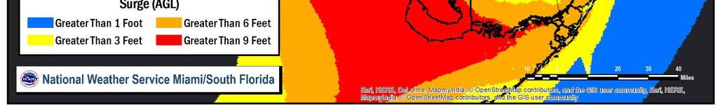
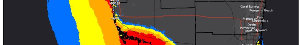
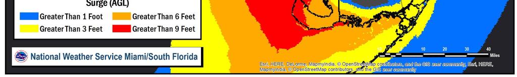
8 Evolution of Potential Surge Threat Graphics with Shifting Track Forecast


9 Evolution of Potential Surge Threat Graphics with Shifting Track Forecast


10 Hurricane Irma Shifting Forecast Forecast Surge Potential adjusted from 4-6 feet 9/8 at 5AM to 7-10 feet across southern Lee County 9/8 at 11PM


11 10% vs 20% Exceedance Examples Hurricane Irma Advisory 39 5

12 Observed Irma Track and Simulated Surge Sanibel Naples Marco Everglades City

13 Observed vs Forecast Simulated Surge Sanibel Sanibel Naples Marco Everglades City Naples Marco ~ 30 nm Everglades City ~ 50,000 people with 3+ foot surge inundation ~ 200,000 people with 3+ foot surge inundation Observed Track Forecast Track from 5 PM Saturday, September 9 th Advisory

14 2017 Hurricane Irma Statistics Second landfall as CAT 3 (115 mph) near Marco Island at 3:30 pm Storm tide of 6-10 ft AGL in the unpopulated coast south of Marco Island. Tides of 3-5 ft AGL from Marco Island to Fort Myers. 92 U.S. Fatalities, 83 were Florida Residents
15 Hurricane Irma The Big Blowout Tides 4-7 feet below normal in Tampa Bay Talking about negative storm surge potential as early as 9/6, but were you expecting this?

16 Hurricane Irma Storm Surge Feet Above MHHW Feet Above MHHW
Storm Surge Forecast with Shifting Forecast Tracks
 Storm Surge Forecast with Shifting Forecast Tracks Storm Surge Findings in the Florida Keys Jon Rizzo Warning Coordination Meteorologist National Weather Service Florida Keys Florida Keys Life History
Are You Ready For Hurricane Season? 2018 Hurricane Talk B Y : S T O R M T E A M 8 M E T E O R O L O G I S T J U L I E P H I L L I P S
 Are You Ready For Hurricane Season? 2018 Hurricane Talk B Y : S T O R M T E A M 8 M E T E O R O L O G I S T J U L I E P H I L L I P S About Me I am Currently a Weekday Meteorologist at WFLA Channel 8.
Tropical Update. 5 PM EDT Sunday, September 10, 2017 Hurricane Irma, Hurricane Jose, Tropical Wave (60%)
") Tropical Update 5 PM EDT Sunday, September 10, 2017 Hurricane Irma, Hurricane Jose, Tropical Wave (60%) This update is intended for government and emergency response officials, and is provided for informational
Tropical Update 5 PM EDT Sunday, September 10, 2017 Hurricane Irma, Hurricane Jose, Tropical Wave (60%) This update is intended for government and emergency response officials, and is provided for informational
2015 Hurricane Season BY: STORM TEAM 8 METEOROLOGIST JULIE PHILLIPS
 2015 Hurricane Season BY: STORM TEAM 8 METEOROLOGIST JULIE PHILLIPS FORECAST COLORADO STATE UNIVERSITY FORECAST IS CALLING FOR ONE OF THE LEAST ACTIVE SEASONS SINCE THE MID 20 TH CENTURY! THE OFFICIAL
Hurricane Irma Page 1 HURRTRAK RM/Pro 2017 Summary Report for Tampa, FL 09/10/ EDT, Adv. # 46
 Hurricane Irma Page 1 Description of impact to Tampa, FL, Tampa, FL, is expected to receive a major impact from Hurricane Irma. The forecast maximum wind for this location has increased since the last
Hurricane Wilma Post Storm Data Acquisition Estimated Peak Wind Analysis and Storm Tide Data. December 27, 2005
 Hurricane Wilma Post Storm Data Acquisition Estimated Peak Wind Analysis and Storm Tide Data December 27, 2005 Hurricane Wilma was the sixth major hurricane of the record-breaking 2005 Atlantic hurricane
TROPICAL STORM NATE BRIEFING
 TROPICAL STORM NATE BRIEFING 5:00 AM CDT Friday, October 6, 2017 Prepared by: NWS NWSNewOrleans www.weather.gov/neworleans Situation Overview No significant changes to the track forecast this morning.
The Impact of Hurricane Irma on the Coast of Florida
 The Impact of Hurricane Irma on the Coast of Florida Ralph Clark, Guy Weeks, Robert Wang, Mike Manausa & Peter Bacopoulos Division of Water Resource Management February 8, 2018 Overview: Hurricane Irma
2017 Hurricane Season and Beyond
 2017 Hurricane Season and Beyond Ken Graham National Hurricane Center Building a Weather-Ready Nation Much of U.S. Coast Saw Tropical Wind Watches or Warnings 2017 Hurricane Season Facts and Figures 7th
2008 Hurricane Caravan. Daniel Noah Meteorologist National Weather Service x1 May 22, 2008
 2008 Hurricane Caravan Daniel Noah Meteorologist National Weather Service daniel.noah@noaa.gov, 813-645-2323 x1 May 22, 2008 National Weather Service We never close! Open 24 hours a day 365 days per year
Hurricane Irma Page 1 HURRTRAK RM/Pro 2017 Summary Report for Tampa, FL 09/09/ EDT, Adv. # 43
 Hurricane Irma Page 1 Description of impact to Tampa, FL, Tampa, FL, is expected to receive a major impact from Hurricane Irma. The forecast maximum wind for this location has decreased since the last
Major Hurricane Matthew Briefing Situation Overview
 Major Hurricane Matthew Briefing Situation Overview At 5 p.m. Tuesday, Category 4 Hurricane Matthew was about 860 miles South-Southeast of Mayport, Florida, moving north around 10 mph. Maximum sustained
Major Hurricane Matthew Briefing Situation Overview
 Major Hurricane Matthew Briefing Situation Overview THIS IS NOW A WORST CASE STORM SURGE SCENARIO Catastrophic Damage is Anticipated for Coastal Areas. Major Hurricane Matthew is still expected to move
HURRICANE FRANCES CHARACTERISTICS and STORM TIDE EVALUATION
 HURRICANE FRANCES CHARACTERISTICS and STORM TIDE EVALUATION ((DRAFT)) By Robert Wang and Michael Manausa Sponsored by Florida Department of Environmental Protection, Bureau of Beaches and Coastal Systems
Probabilistic Hurricane Storm Surge A Local Perspective
 Probabilistic Hurricane Storm Surge A Local Perspective Florida Governor Hurricane Conference May 11-16 2014 2014 FLGHC TS 22 Pablo Santos Meteorologist In Charge NWS Miami/South Florida Forecast Office
Tropical Update. 12 PM EDT Friday, October 7, 2016 Hurricane Matthew & Tropical Storm Nicole
 Tropical Update 12 PM EDT Friday, October 7, 2016 Hurricane Matthew & Tropical Storm Nicole This update is intended for government and emergency response officials, and is provided for informational and
Tropical Storm Harvey: SE Texas Impacts
 Tropical Storm Harvey: SE Texas Impacts 10 AM CDT UPDATE Thursday, August 24, 2017 Prepared by: Dan Reilly, Brian Kyle PLEASE MUTE YOUR LINES AND DON T PUT ON HOLD! Situation Overview Tropical Storm Harvey
Tropical Update. 5 AM EDT Tuesday, September 12, 2017 Post-Tropical Cyclone Irma, Hurricane Jose, & Tropical Wave (10%)
") Tropical Update 5 AM EDT Tuesday, September 12, 2017 Post-Tropical Cyclone Irma, Hurricane Jose, & Tropical Wave (10%) This update is intended for government and emergency response officials, and is provided
Tropical Update 5 AM EDT Tuesday, September 12, 2017 Post-Tropical Cyclone Irma, Hurricane Jose, & Tropical Wave (10%) This update is intended for government and emergency response officials, and is provided
HURRICANE CHARLEY CHARACTERISTICS and STORM TIDE EVALUATION
 HURRICANE CHARLEY CHARACTERISTICS and STORM TIDE EVALUATION By Robert Wang, Michael Manausa And Jenny Cheng Sponsored by Florida Department of Environmental Protection, Bureau of Beaches and Coastal Systems
Major Hurricane Earl
 Major Hurricane Earl Advisory 32 North Carolina Threat Assessment Prepared at: 8 AM Thursday September 2, 2010 Hurricane and Tropical Storm Warnings in effect for the North Carolina Coast and Sounds. NWS
Major Hurricane Earl
 Major Hurricane Earl Advisory 33 North Carolina Threat Assessment Prepared at: 11 AM Thursday September 2, 2010 Hurricane and Tropical Storm Warnings in effect for the North Carolina Coast and Sounds NWS
Tropical Update. 5 PM EDT Thursday, September 7, 2017 Hurricane Irma, Hurricane Jose, and Hurricane Katia
 Tropical Update 5 PM EDT Thursday, September 7, 2017 Hurricane Irma, Hurricane Jose, and Hurricane Katia This update is intended for government and emergency response officials, and is provided for informational
SLOSH New Orleans Basin 2012 Update
 SLOSH New Orleans Basin 2012 Update Michael Koziara Science and Operations Officer National Weather Service Slidell, LA The Basics What is storm surge? What is SLOSH? Details Assumptions Inundation = Storm
NWS HURRICANES June 3, 2015
 NWS HURRICANES June 3, 2015 Hurricane Season June 1 November 30 2 What s the concern? All tropical systems passing within 125nm of central Maryland since 1950 Mid-Atlantic Hurricanes Greatest Risk: August
WEDNESDAY 30 TH AUGUST, :57 p.m. Tropical Storm Irma forms in the Atlantic. Don t let your guard down, always #Be Ready.
 Chapter 1 - The Set Up In the days leading up to Irma a series of composed and sobering text messages, presented in truncated form below, from Department of Disaster Management warned us of the pending
Current Details from the National Hurricane Center (NHC)
") Current Watches and Warnings A Hurricane Warning is in effect from Fernandina Beach southward around the Florida peninsula to Indian Pass; Florida Keys; Lake Okeechobee; Florida Bay A Hurricane Watch is
Current Watches and Warnings A Hurricane Warning is in effect from Fernandina Beach southward around the Florida peninsula to Indian Pass; Florida Keys; Lake Okeechobee; Florida Bay A Hurricane Watch is
STORM HISTORY FOR COLLIER COUNTY
 STORM HISTORY FOR COLLIER COUNTY In 1960, when hurricane 'Donna' struck, there were approximately 15,500 people living full time in Collier County. Today there are more than 330,000 residents, most of
Tropical Update. 11 AM EDT Wednesday, October 10, 2018 Hurricane Michael, Hurricane Leslie & Tropical Storm Nadine, Caribbean Low (40%)
") Tropical Update 11 AM EDT Wednesday, October 10, 2018 Hurricane Michael, Hurricane Leslie & Tropical Storm Nadine, Caribbean Low (40%) This update is intended for government and emergency response officials,
Tropical Update 11 AM EDT Wednesday, October 10, 2018 Hurricane Michael, Hurricane Leslie & Tropical Storm Nadine, Caribbean Low (40%) This update is intended for government and emergency response officials,
What s s New for 2009
 What s s New for 2009 Graphical Tropical Weather Outlook becomes operational Special Tropical Disturbance Statement replaced with Special Tropical Weather Outlook Tropical Cyclone Wind Field Graphic becomes
HURRICANE IRMA. 12 PM ET Saturday, September Prepared by: Kyle Thiem / Sid King.
 HURRICANE IRMA 12 PM ET Saturday, September 9 2017 Prepared by: Kyle Thiem / Sid King www.weather.gov/atlanta/briefings @NWSAtlanta www.weather.gov/atlanta Situation Overview 11:00 AM EDT Sat Sep 9 Location:
TROPICAL DEPRESSION HARVEY BRIEFING
 TROPICAL DEPRESSION HARVEY BRIEFING 10:15 PM CDT Wednesday, August 23, 2017 Prepared by: Lara Beal NWSCorpus www.weather.gov/corpuschristi Situation Overview No changes to Watches. Hurricane Watch remains
Tropical Update. 5 AM EDT Wednesday, September 6, 2017 Hurricane Irma, Tropical Storm Jose, and Tropical Storm Katia
 Tropical Update 5 AM EDT Wednesday, September 6, 2017 Hurricane Irma, Tropical Storm Jose, and Tropical Storm Katia This update is intended for government and emergency response officials, and is provided
Hurricane Charley: A Retrospective 2014 Florida Governor s Hurricane Conference
 Hurricane Charley: A Retrospective 2014 Florida Governor s Hurricane Conference 2004 Hurricane Season: Storm Tracks Satellite Images of 2004 Hurricanes Charley Frances Ivan Jeanne Three Hurricanes in Polk
HURRICANE IVAN CHARACTERISTICS and STORM TIDE EVALUATION
 HURRICANE IVAN CHARACTERISTICS and STORM TIDE EVALUATION By Robert Wang and Michael Manausa Sponsored by Florida Department of Environmental Protection, Bureau of Beaches and Coastal Systems Submitted
The Worst Places for Hurricanes
 The Worst Places for Hurricanes Hurricane Hotspots By now, everyone knows that the last two hurricane seasons have been particularly severe. Severe yes, but compared to what? Hurricane experts are saying
Saturday, October 6, :30 a.m. EDT
 Saturday, October 6, 2018 8:30 a.m. EDT Significant Activity Oct 5-6 Significant Events: None Tropical Activity: Atlantic Tropical Storm Leslie; Disturbance 1 (High: 90%) Eastern Pacific Hurricane Sergio
Tropical Update. 5 AM EDT Monday, October 8, 2018 Tropical Storm Michael, Tropical Storm Leslie, Invest 92L (10%) & African Tropical Wave (50%)
 & African Tropical Wave (50%)") Tropical Update 5 AM EDT Monday, October 8, 2018 Tropical Storm Michael, Tropical Storm Leslie, Invest 92L (10%) & African Tropical Wave (50%) This update is intended for government and emergency response
Tropical Update 5 AM EDT Monday, October 8, 2018 Tropical Storm Michael, Tropical Storm Leslie, Invest 92L (10%) & African Tropical Wave (50%) This update is intended for government and emergency response
Tropical Update. 5 AM EDT Thursday, September 7, 2017 Hurricane Irma, Hurricane Jose, and Hurricane Katia
 Tropical Update 5 AM EDT Thursday, September 7, 2017 Hurricane Irma, Hurricane Jose, and Hurricane Katia This update is intended for government and emergency response officials, and is provided for informational
Tropical Update. 5 PM EDT Sunday, October 7, 2018 Tropical Storm Michael, Tropical Storm Leslie, & Invest 92L (30%)
") Tropical Update 5 PM EDT Sunday, October 7, 2018 Tropical Storm Michael, Tropical Storm Leslie, & Invest 92L (30%) This update is intended for government and emergency response officials, and is provided
Tropical Update 5 PM EDT Sunday, October 7, 2018 Tropical Storm Michael, Tropical Storm Leslie, & Invest 92L (30%) This update is intended for government and emergency response officials, and is provided
Tropical Update 6 AM EDT Friday, October 7, 2016 Hurricane Matthew & Hurricane Nicole
 Tropical Update 6 AM EDT Friday, October 7, 2016 Hurricane Matthew & Hurricane Nicole This update is intended for government and emergency response officials, and is provided for informational and situational
RSMC-Miami Update Daniel Brown Warning Coordination Meteorologist
 RSMC-Miami Update 2016 Daniel Brown Warning Coordination Meteorologist L-0324 Emergency Management Hurricane Preparedness Training Course Funding provided by FEMA s National Hurricane Program - partnership
Tropical Update. 11 AM EDT Tuesday, October 9, 2018 Hurricane Michael, Tropical Storm Leslie, Tropical Storm Nadine
 Tropical Update 11 AM EDT Tuesday, October 9, 2018 Hurricane Michael, Tropical Storm Leslie, Tropical Storm Nadine This update is intended for government and emergency response officials, and is provided
Hurricane Matthew Page 1 Location Forecast Analysis Summary Report - Advanced Wind Estimation On
 Page 1 Current NHC Forecast Predictions Maximum Sustained Winds / Storm Category: 138 MPH / Category 4 Forward motion: 9 mph towards the North Hurricane Force winds extend from the center: 46 miles Tropical
GC Briefing. Weather Sentinel Tropical Storm Michael. Status at 8 AM EDT (12 UTC) Today (NHC) Discussion. October 11, 2018
 Today (NHC) Discussion. October 11, 2018") GC Briefing Weather Sentinel Tropical Storm Michael October 11, 2018 After making landfall as a high-end category-4 hurricane on the Florida Panhandle, Michael weakened to tropical storm status early this
GC Briefing Weather Sentinel Tropical Storm Michael October 11, 2018 After making landfall as a high-end category-4 hurricane on the Florida Panhandle, Michael weakened to tropical storm status early this
Draft for Discussion 11/11/2016
 Coastal Risk Consulting (CRC) Climate Vulnerability Assessment for Village of Key Biscayne Deliverable 1.1 in Statement of Work. Preliminary Vulnerability Assessment Identifying Flood Hotspots Introduction...
Wind field has expanded and is very large. Hurricane Wind field = 100 miles wide, Tropical Storm Wind field = 360 miles wide
 HURRICANE IRMA 12 PM ET Sunday, September 10 2017 Prepared by: Keith Stellman / Kyle Thiem www.weather.gov/atlanta/briefings @NWSAtlanta www.weather.gov/atlanta Situation Overview 11:10 AM EDT Sun Sep
Tropical Storm Colin Briefing Last Briefing on this System
 Tropical Storm Colin Briefing Last Briefing on this System NWS WFO Jacksonville, Florida Tuesday, June 07, 2016 6:00 a.m. EDT Tropical Storm Colin s Impacts SE Georgia & North Florida Local Watches & Warnings:
HURRICANE JEANNE CHARACTERISTICS and STORM TIDE EVALUATION
 HURRICANE JEANNE CHARACTERISTICS and STORM TIDE EVALUATION ((DRAFT)) By Robert Wang and Michael Manausa Sponsored by Florida Department of Environmental Protection, Bureau of Beaches and Coastal Systems
Current Details from the National Hurricane Center (NHC)
") Current Watches and Warnings A Hurricane Warning is in effect from Fernandina Beach southward around the Florida peninsula to the Aucilla River; Florida Keys; Lake Okeechobee; Florida Bay; Cuban provinces
Current Watches and Warnings A Hurricane Warning is in effect from Fernandina Beach southward around the Florida peninsula to the Aucilla River; Florida Keys; Lake Okeechobee; Florida Bay; Cuban provinces
Hurricanes, Sea Level Rise, and South Florida s Challenging Future
 Hurricanes, Sea Level Rise, and South Florida s Challenging Future Brian McNoldy Senior Research Associate University of Miami Tropical Weather Expert Washington Post Scientific Advisor Coastal Risk Consulting
Satellite and Radar. 5:55 am Infrared Satellite with Surface Wind Arrows. 6:15 am Ruskin Doppler Radar. Large southerly wind field
 Satellite and Radar 5:55 am Infrared Satellite with Surface Wind Arrows 6:15 am Ruskin Doppler Radar Large southerly wind field Developing showers rotating onshore NHC Forecast Hurricane Warning Big Bend
Hurricane Irma. Willis Re Hurricane Damage Survey Report. Executive Summary
 Willis Re Hurricane Damage Survey Report Hurricane Irma Willis Re s post-event field damage survey report Representatives from Willis Re spent four days in the field assessing the damage caused by Hurricane
Hurricane Matthew Threats and Impacts Briefing for Eastern NC
 Hurricane Matthew Threats and Impacts Briefing for Eastern NC October 6 th, 2016 Date/Time Created: 10/6/2016, Noon EDT National Weather Service Newport/Morehead City, NC Hurricane Matthew Key Points Changes
A HURRICANE IS COMING. Presented by Atiba Upchurch Broward Emergency Management Division
 A HURRICANE IS COMING Presented by Atiba Upchurch Broward Emergency Management Division Mission Statement To safeguard the lives and property of the people of Broward County from major hazards and emergencies
Tropical Storm Ana. Created 6:00 AM Sun May 10, 2015 John Cole Warning Coordination Meteorologist
 Tropical Storm Ana Threat Assessment for Eastern North Carolina Created 6:00 AM Sun May 10, 2015 John Cole Warning Coordination Meteorologist John.cole@noaa.gov National Weather Service Newport/Morehead
Canes on Canes: Keeping South Florida Prepared During the Calm Before the Storm. Matt Onderlinde and Pete Finocchio
 Canes on Canes: Keeping South Florida Prepared During the Calm Before the Storm Matt Onderlinde and Pete Finocchio Outline The Science of Hurricanes Why and When South Floridians Must Be Weather-Ready
Miami-Dade County Overview
 Miami-Dade County Overview 2,000 square miles World s busiest cruise port 2.6 million residents Second busiest US airport for international travelers Gateway to the Caribbean and Latin America Natural
Monitoring Hurricane Rita Inland Storm Surge
 Monitoring Hurricane Rita Inland Storm Surge By Benton D. McGee, Roland W. Tollett, and Burl B. Goree Pressure transducers (sensors) are accurate, reliable, and cost-effective tools to measure and record
Wind Speed Probability Products. Daniel Brown and Michael Brennan National Hurricane Center
 Wind Speed Probability Products Daniel Brown and Michael Brennan National Hurricane Center 2017 WMO Course 7 March 2017 Wind Speed Probabilities A Tool to Deal with Uncertainty Hurricane Irene Advisory
Wind Speed Probability Products
 Wind Speed Probability Products Daniel Brown National Hurricane Center 2018 WMO Course 6 March 2018 Wind Speed Probabilities A Tool to Deal with Uncertainty Hurricane Irene Advisory Number 12 Issued 5:00
An Analysis of Hurricane Irma s Maximum Winds in South Florida. Andrew B. Hagen, Kevin Scharfenberg, Arlena Moses, Stephen Konarik, Robert Garcia
 An Analysis of Hurricane Irma s Maximum Winds in South Florida Andrew B. Hagen, Kevin Scharfenberg, Arlena Moses, Stephen Konarik, Robert Garcia Hurricane Irma struck South Florida on 10 September 2017
Tropical Storm Isaac Situation Report #2 Monday, August 27, :30 PM (EDT)
") Tropical Storm Isaac Situation Report #2 Monday, August 27, 2012 2:30 PM (EDT) CURRENT SITUATION: RAINFALL BEGINS TO IMPACT THE FLORIDA GULF COAST... FLORIDA, MISSISSIPPI, LOUISIANA, AND ALABAMA HAVE DECLARED
Tropical Storm Isaac Situation Report #2 Monday, August 27, 2012 2:30 PM (EDT) CURRENT SITUATION: RAINFALL BEGINS TO IMPACT THE FLORIDA GULF COAST... FLORIDA, MISSISSIPPI, LOUISIANA, AND ALABAMA HAVE DECLARED
Experimental Probabilistic Hurricane Inundation Surge Height (PHISH) Guidance
 Guidance") Experimental Probabilistic Hurricane Inundation Surge Height (PHISH) Guidance DRBC Flood Advisory Committee John Kuhn - NWS/OCWWS Anne Myckow (NWS/MDL), Arthur Taylor (NWS/MDL) SLOSH Sea, Lake and Overland
Experimental Probabilistic Hurricane Inundation Surge Height (PHISH) Guidance DRBC Flood Advisory Committee John Kuhn - NWS/OCWWS Anne Myckow (NWS/MDL), Arthur Taylor (NWS/MDL) SLOSH Sea, Lake and Overland
Current Details from the National Hurricane Center (NHC)
") Current Watches and Warnings A Warning is in effect from Anclote River to the Okaloosa/Walton County Line; north of the Volusia/Brevard County line to the South Santee River A Surge Warning is in effect
Current Watches and Warnings A Warning is in effect from Anclote River to the Okaloosa/Walton County Line; north of the Volusia/Brevard County line to the South Santee River A Surge Warning is in effect
10 years after Hurricane Charley
 10 years after Hurricane Charley Hurricane Charley (2004) A Retrospective Scott M. Spratt Warning Coordination Meteorologist NWS Melbourne, FL Florida Governors Hurricane Conference May 15, 2014 11 AM
Frank Revitte National Weather Service. Weather Forecast Office New Orleans/Baton Rouge
 Frank Revitte National Weather Service Weather Forecast Office New Orleans/Baton Rouge Above normal activity 17 Total Named Storms 7 Tropical Storms 4 Hurricanes 6 Major Hurricanes Not the most active,
HURRICANE HARVEY COE Navigation BRIEFING
 HURRICANE HARVEY COE Navigation BRIEFING 10:00 AM CDT Friday, August 25, 2017 NWSNewOrleans www.weather.gov/neworleans Situation Overview New Information Harvey continues to strengthen Max sustained winds
Current Details from the National Hurricane Center (NHC)
") Current Watches and Warnings A Hurricane Warning is in effect from Fernandina Beach southward around the Florida peninsula to the Indian Pass; Florida Keys; Lake Okeechobee; Florida Bay; Cuban provinces
Current Watches and Warnings A Hurricane Warning is in effect from Fernandina Beach southward around the Florida peninsula to the Indian Pass; Florida Keys; Lake Okeechobee; Florida Bay; Cuban provinces
October 17, 2018 Sea level rise observed since 1970 responsible for 43% of homes impacted by Hurricane Irma s storm surge
 October 17, 2018 Sea level rise observed since responsible for 43% of homes impacted by s storm surge (NEW YORK, N.Y.) Data scientists from the non-profit First Street Foundation in collaboration with
Advisory #35 Briefing 630 PM EDT Thursday October 06, 2016
 Advisory #35 Briefing 630 PM EDT Thursday October 06, 2016 Disclaimer: The information contained within this briefing is time-sensitive, do not use beyond 6 hours after the issuance Next Webinar Update:
Hurricane Matthew. Life Threatening Flash Flooding Likely. National Weather Service Wilmington NC. Josh Weiss, Meteorologist
 Hurricane Matthew Life Threatening Flash Flooding Likely Threat Assessment for northeast South Carolina & southeast North Carolina National Weather Service Wilmington NC 630 PM EDT Friday October 7, 2016
Hurricane Harvey: SE Texas Impacts. 10 AM CDT UPDATE Saturday, August 26, 2017 Prepared by: Dan Reilly, Brian Kyle
 Hurricane Harvey: SE Texas Impacts 10 AM CDT UPDATE Saturday, August 26, 2017 Prepared by: Dan Reilly, Brian Kyle Latest Observations and Radar Hurricane Harvey centered near Victoria and weakening Wind
Hurricane Matthew. National Weather Service Wilmington NC. Steven Pfaff, WCM.
 Hurricane Matthew Threat Assessment for northeast South Carolina & southeast North Carolina National Weather Service Wilmington NC 515 PM EDT Monday October 3, 2016 Steven Pfaff, WCM Steven.Pfaff@noaa.gov
AASHTO Committee on Maintenance 2018 Annual Meeting July 25, Hurricane Irma- Preparation and Response
 AASHTO Committee on Maintenance 2018 Annual Meeting July 25, 2018 Hurricane Irma- Preparation and Response Rudy Powell Director, Office of Maintenance Satellite Aerial Image (September 10, 2017) Hurricane
NOAA Storm Surge Modeling Gaps and Priorities
 NOAA Storm Surge Modeling Gaps and Priorities HFIP Meeting November 9 th, 2017 Laura Paulik Alaka NHC Storm Surge Unit Introduction to Probabilistic Storm Surge P-Surge is based on an ensemble of Sea,
HURRICANES IRMA AND MARIA
 EXECUTIVE SUMMARY HURRICANES IRMA AND MARIA Bloomberg Philanthropies USVI Hurricane Recovery and Resilience Task Force 1 Hurricanes Irma and Maria, both Category 5 storms with wind gusts of up to 178 MPH
TROPICAL STORM NATE BRIEFING
 TROPICAL STORM NATE BRIEFING 2:00 PM CDT Friday, October 06, 2017 Prepared by: NWS NWSNewOrleans www.weather.gov/neworleans Situation Overview Track forecast has not changed since the 10 am advisory. Hurricane
2006 & 2007 Pre-Hurricane Scenario Analyses
 2006 & 2007 Pre-Hurricane Scenario Analyses Executive Summary May 2007 Page 1 OF X FOR OFFICIAL USE ONLY 4 Public Availability to be Determined Under 5 U.S.C. 552 NOTE: Limited Distribution. Release of
Hurricane Harvey: SE Texas Impacts. 10 PM CDT UPDATE Friday, August 25, 2017 Prepared by: Lance Wood
 Hurricane Harvey: SE Texas Impacts 10 PM CDT UPDATE Friday, August 25, 2017 Prepared by: Lance Wood Latest Observations Hurricane Harvey making landfall this evening near Rockport as a category 4 hurricane.
Case Studies in Communication Challenges: Hurricane Sandy
 Case Studies in Communication Challenges: Hurricane Sandy International Workshop on Tropical Cyclones Jeju Island, South Korea Chris Landsea, National Hurricane Center, RSMC Miami Major Hurricane Sandy
Preliminary Assessment of 2017 Atlantic Hurricane Season. Phil Klotzbach. Department of Atmospheric Science. Phil Klotzbach
 Atlantic Basin Basin Tropical Seasonal Cyclone Hurricane Climatology Prediction and Preliminary Assessment of 2017 Atlantic Hurricane Season Phil Klotzbach Department of Atmospheric Science Colorado Phil
Hurricane Matthew. National Weather Service Wilmington NC. Steven Pfaff, WCM.
 Hurricane Matthew Threat Assessment for northeast South Carolina & southeast North Carolina National Weather Service Wilmington NC 730 AM EDT Tuesday October 4, 2016 Steven Pfaff, WCM Steven.Pfaff@noaa.gov
TROPICAL STORM HARVEY BRIEFING
 TROPICAL STORM HARVEY BRIEFING 10:00 AM CDT Sunday, August 27, 2017 Prepared by: NWS LIX NWSNewOrleans www.weather.gov/neworleans Situation Overview New Information Tropical Storm Winds 40mph Immediate
TROPICAL STORM NATE BRIEFING
 TROPICAL STORM NATE BRIEFING 10:30 AM CDT Friday, October 06, 2017 Prepared by: NWS NWSNewOrleans www.weather.gov/neworleans Situation Overview Track forecast has shifted slightly eastward. Hurricane Watch
National Situation Report As of 3:00 a.m. EDT, Thursday, September 21, 2017 Table of Contents Current Operations Monitoring Recovery
 25k Overview National Situation Report As of 3:00 a.m. EDT, Thursday, September 21, 2017 Table of Contents Current Operations Monitoring Recovery FEMA Headquarters Status FEMA Region Status NRCC Level
Table 1. August average temperatures and departures from normal ( F) for selected cities.
 for selected cities.") Climate Summary for Florida August 2016 Prepared by Lydia Stefanova and David Zierden Florida Climate Center, The Florida State University, Tallahassee, Florida Online at: http://climatecenter.fsu.edu/products-services/summaries
Climate Summary for Florida August 2016 Prepared by Lydia Stefanova and David Zierden Florida Climate Center, The Florida State University, Tallahassee, Florida Online at: http://climatecenter.fsu.edu/products-services/summaries
Planning for Annapolis Sea Level Rise and Future Extreme Water Levels
 Planning for Annapolis Sea Level Rise and Future Extreme Water Levels U.S. Naval Academy Sea Level Rise Advisory Council 31 October 2017 CAPT Emil Petruncio, USN (Ret.), PhD Associate Professor Gina Henderson
Vulnerability Metrics of Hurricane Forecast Accuracy
 Vulnerability Metrics of Hurricane Forecast Accuracy Adam D. Arnold 1 and Jenni L. Evans 2 Department of Meteorology, The Pennsylvania State University University Park, PA 16802 Submitted to Weather and
Diagnosing the Large Swell Event Associated with the Extratropical Transition of Hurricane Florence
 Diagnosing the Large Swell Event Associated with the Extratropical Transition of Hurricane Florence Mark Willis National Hurricane Center Tropical Analysis and Forecast Branch (TAFB) Thanks to: Jack Beven,
HURRICANE IRENE. CONFERENCE CALL BRIEFING SLIDES Saturday August 27, :30 AM
 HURRICANE IRENE CONFERENCE CALL BRIEFING SLIDES Saturday August 27, 2011 8:30 AM NHC TRACK AND CONE HURRICANE IRENE WATCHES/WARNINGS Hurricane Warning along south coast including all of Cape Cod and Islands
Current Situation Report Hurricane Irma - Atlantic Ocean - Current Situation Report - 08 Sep 17 (Update 03)
") Current Situation Report Hurricane Irma - Atlantic Ocean - Current Situation Report - 08 Sep 17 (Update 03) Date As Of: 09/08/2017 21:39:11 Sitrep Update #: 03 Incident Start Time: 09/06/2017 12:09:38
Current Situation Report Hurricane Irma - Atlantic Ocean - Current Situation Report - 08 Sep 17 (Update 03) Date As Of: 09/08/2017 21:39:11 Sitrep Update #: 03 Incident Start Time: 09/06/2017 12:09:38
Daily Operations Briefing. Wednesday, September 20, :30 a.m. EDT
 Daily Operations Briefing Wednesday, September 20, 2017 8:30 a.m. EDT Significant Activity Sep 19-20 Significant Events: Response for Post Tropical Cyclone Irma, Preparation for Hurricane Jose & Maria
HVX-HURREVAC (Beta) Webinar Series
 Webinar Series") HVX-HURREVAC (Beta) Webinar Series Day 1 - An introduction to HURREVAC and the new web-based HVX platform 2018 HVX-HURREVAC Webinar Series 1. Intro to HURREVAC and General Overview of the Program (August
HVX-HURREVAC (Beta) Webinar Series Day 1 - An introduction to HURREVAC and the new web-based HVX platform 2018 HVX-HURREVAC Webinar Series 1. Intro to HURREVAC and General Overview of the Program (August
Tropical Update. 5 PM EDT Thursday, August 27, 2015 Tropical Storm Erika
 Tropical Update 5 PM EDT Thursday, August 27, 2015 Tropical Storm Erika This update is intended for government and emergency response officials, and is provided for informational and situational awareness
Hurricane Lane. Hawaiian Islands, August By Ian Robertson 1, Ph.D., P.E.
 Hurricane Lane Hawaiian Islands, August 2018 By Ian Robertson 1, Ph.D., P.E. Hurricane Lane, a major Pacific Ocean hurricane, narrowly missed making landfall on the main Hawaiian Islands, but still caused
Hurricane Sandy October 28 th 31 st 2012
 Hurricane Sandy October 28 th 31 st 2012 Prepared 530 PM EDT Saturday October 27, 2012 Gary Szatkowski NOAA s NJ Forecast Office Weather.gov/phi Purpose of Briefing Briefing #7 for event Promote situational
3301 Rickenbacker Causeway, Miami, FL 33149
 Virginia Key and Miami Beach 2016 King Tide Report and Projections (to 2045) using: 3301 Rickenbacker Causeway, Miami, FL 33149 *THIS REPORT IS PROVIDED SUBJECT TO THE COASTAL RISK CONSULTING, LLC, PRINTED
Storm Summary for Hurricane Joaquin
 Storm Summary for Hurricane Joaquin Wednesday, September 30, 2015 at 5 PM EDT (Output from Hurrevac, based on National Hurricane Center Forecast Advisory #12) Joaquin is currently a Category 1 hurricane
ARUBA CLIMATOLOGICAL SUMMARY 2017 PRECIPITATION
 ARUBA CLIMATOLOGICAL SUMMARY 2017 PRECIPITATION The total amount of rainfall recorded at Reina Beatrix International Airport for the year 2017 was 391.0 mm. This is 17.1 % below normal ( Figure 1 ). During
HURRICANES. Source:
 HURRICANES Source: http://www.dc.peachnet.edu/~pgore/students/w97/matheson/hpage.htm What is a hurricane? Violent cyclonic storm that develops in the tropical region Wind speeds are > 74 mph Source: http://www.google.com/imgres?hl=en&sa=x&biw=1920&bih=955&tbm=