Diagnosing the Large Swell Event Associated with the Extratropical Transition of Hurricane Florence
|
|
|
- Chastity Day
- 5 years ago
- Views:
Transcription
 Thanks to: Jack Beven, Robbie Berg, John Cangiolosi, and Jamie")
1 Diagnosing the Large Swell Event Associated with the Extratropical Transition of Hurricane Florence Mark Willis National Hurricane Center Tropical Analysis and Forecast Branch (TAFB) Thanks to: Jack Beven, Robbie Berg, John Cangiolosi, and Jamie Rhome.
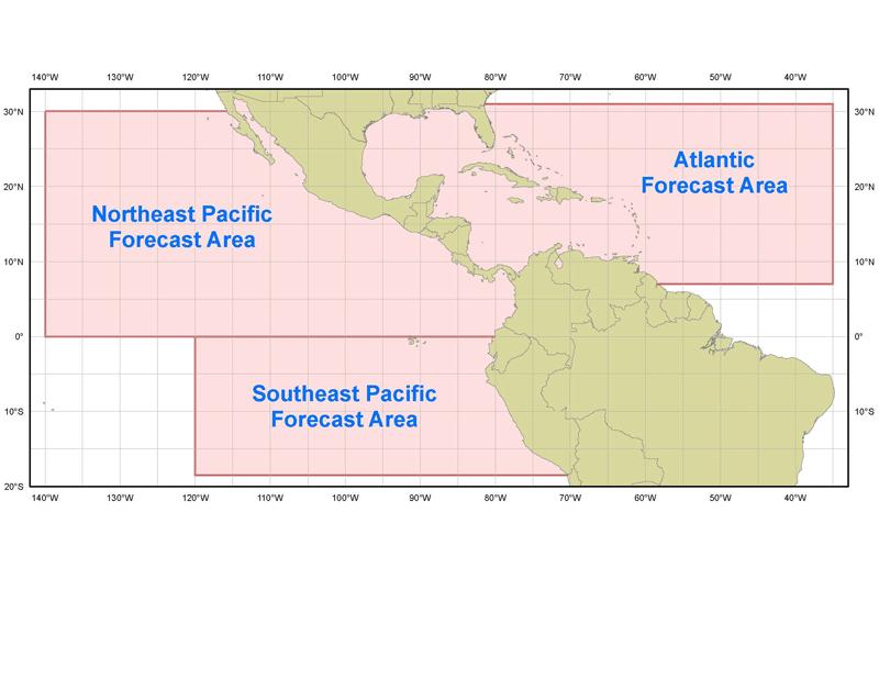
2 TAFB Area of Responsibility
3 MOTIVATION PROTECT LIFE AND PROPERTY At least two drownings, hundreds of ocean rescues, erosion, and flooding resulted from this swell event. 22% of all tropical cyclone related deaths are offshore or surf related (2 nd only to inland flooding), Rappaport (2000). Improve public misperceptions of swell events from tropical cyclones the category and type of storm don t matter! Wave model guidance did not represent the peak of the swell event very well. Why? Improve NWS/NCEP marine forecast products.
4 METHODOLOGY A detailed case study was performed to understand the social and scientific challenges associated with the large swell event from Hurricane Florence. Gain an understanding for the meteorology in hindsight what atmospheric patterns made the waves so big? Compared strengths and weaknesses in the available wave model guidance at TAFB NWW3, NAH WW3, WNA WW3, FNMOC WW3. Located problems in the GFDL and GFS wind forcing that led to problems in the NAH and WNA models. Compared swell of Florence (Cat 1) to Luis (Cat 4).
5 CONCLUSIONS This uniquely large swell event was due to: large storm from origin, ET, interaction with strong Canadian high pressure that built south. NAH and WNA WW3 s low with height and period offshore Florida on 14 Sept due to problems in the GFDL and GFS wind forcing on 13 Sept. WW3 s OVERestimated the heights and low with the periods off Cape Hatteras for the same reason. As marine forecasters, we always need to get a handle on the wind progs first, then waves. NAH isn t always better than WNA for tropical cyclones especially ones going through ET. Further outreach is needed to inform the public of potential indirect dangers of tropical cyclones (Swells and Surf!), and the misperceptions of the Saffir Simpson scale.
6 Hurricane Florence ( Sept 2006) Hurricane Florence 3-12 September 2006 Hurricane Tropical Storm Tropical Dep. 50 Extratropical Subtr. Storm Subtr. Dep Low / Wave 00 UTC Pos/Date 12 UTC Position PPP Min. press (mb) 13 NE swell peaking in Florida after NHC advisories ceased mb

7 Hurricane Florence ( Sept 2006)

8 THE METEOROLOGY Large storm from origin. Strong high pressure over Canada built south Sept. This allowed significant NE fetch to build SW towards Florida. Led to peak of swell in FL as Florence seemingly was not a threat and moving out to sea. NWS/NCEP Unified Surface Analysis 12Z 11 Sept 2006

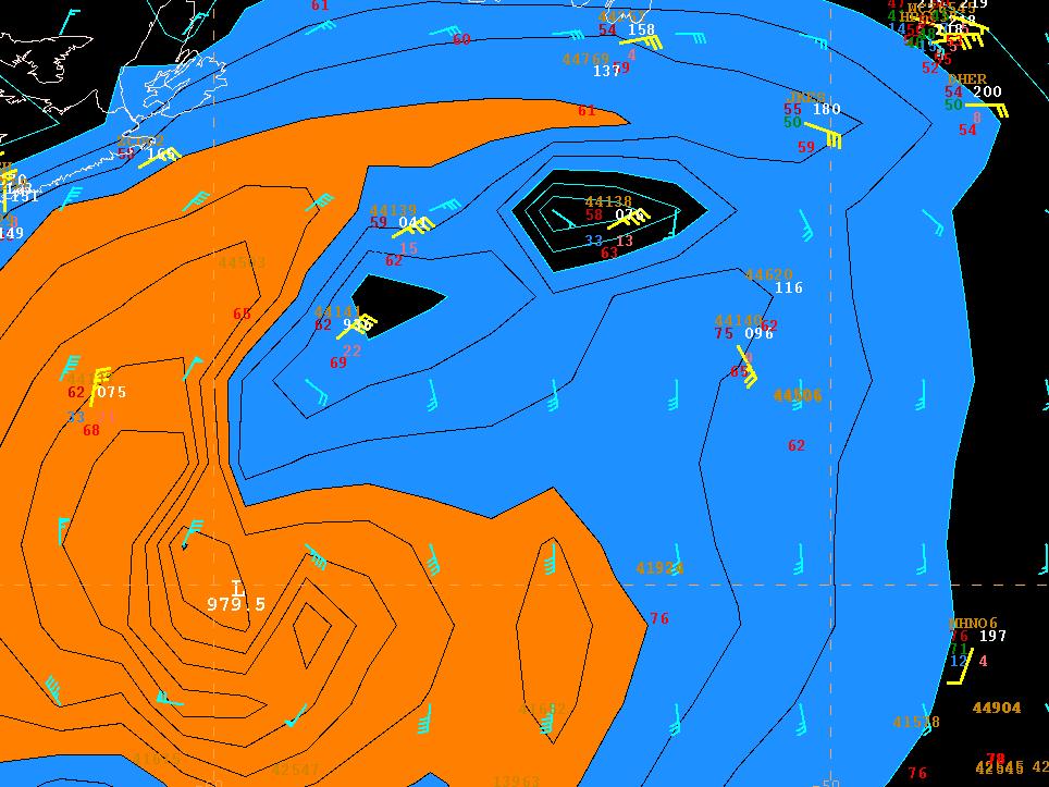
9 Wave Model Verification Swell Peaking in Florida when Florence was moving out to sea and no longer tropical dangerous! Wave heights offshore Central Florida

10 Wave Model Verification Wave periods offshore Central Florida

11 Wave Model Verification Wave heights offshore Cape Hatteras
12 Wave Model Verification Wave periods offshore Cape Hatteras
 vs.")
13 Why were the NAH and WNA WW3 s off? The wind forcing! GFDL Winds (used in NAH WW3) vs. Observations
14

15 Why were the NAH and WNA WW3 s off? The wind! GFS better than GFDL with developing frontal structure N/NE of center, worse with high winds near core. GFS Winds (used in WNA WW3) vs. Observations
 Luis")
16 Florence (Cat 1, 2006) vs. Luis (Cat 4, 1995) Luis Florence
 (83-95 kt) Pres: 965-979 mb Pres: 965-979 mb 28.50-28.")
 (114-135 kt) Pres: 920-944 mb Pres: 920-944 mb 27.17-27.")

17 Saffir-Simpson Scale * Denotes major hurricane Category Category 1 Winds: mph Winds: mph (64-82 kt) (64-82 kt) Pres: > 980 mb Pres: > 980 mb "Hg "Hg Category Category 2 Winds: mph Winds: mph (83-95 kt) (83-95 kt) Pres: mb Pres: mb "Hg "Hg Category Category 3* 3* Winds: mph Winds: mph ( kt) ( kt) Pres: mb Pres: mb "Hg "Hg Category Category 4* 4* Winds: mph Winds: mph ( kt) ( kt) Pres: mb Pres: mb "Hg "Hg Category Category 5* 5* Winds: > 155 mph Winds: > 155 mph (> 135 kt) (> 135 kt) Pres: < 920 mb Pres: < 920 mb <27.16 "Hg <27.16 "Hg Storm surge: 4-5 ft ft above normal. Some coastal road flooding and minor pier damage. Wind Damage: Primarily to unanchored mobile homes, shrubbery, and trees. Some damage to poorly constructed signs. Scattered downed power lines and power outages. Storm surge: 6-8 feet above normal. Coastal and low-lying escape routes flood 2-4 hours before arrival of the center. Wind Damage: Some roofing material, doors, and window of buildings. Considerable damage to shrubbery and trees with some trees blown down. Considerable damage to mobile homes, poorly constructed signs, and piers. Small craft in unprotected anchorages break moorings. downed power lines and power outages. Storm surge: 9-12 ft ft above normal. Low-lying escape routes cut by rising water 3-5 hours before arrival of the center of the hurricane. Flooding near coast destroys smaller structures with larger structures damaged by battering from floating debris. Terrain lower than 5 ft ft above mean sea level may be flooded inland 8 miles or more. Wind Damage: Some structural damage to small residences and utility buildings with minor amount of curtain wall failures. Foliage blown off trees and large trees blown down. Mobile homes and poorly constructed signs destroyed. Numerous downed power lines and power outages. Storm Storm surge: surge: ft ft above above normal. normal. Low-lying Low-lying escape escape routes routes may may be be cut cut by by rising rising water water hours hours before before arrival arrival of of the the center center of of the the hurricane. hurricane. Major Major damage damage to to lower lower floors floors of of structures structures near near the the shore. shore. Terrain Terrain lower lower than than ft ft above above sea sea level level may may be be flooded flooded requiring requiring massive massive evacuation evacuation of of residential residential areas areas as as far far inland inland as as 6 6 miles. miles. Wind Wind Damage: Damage: Extensive Extensive curtain curtain wall wall failures failures with with some some complete complete roof roof failures failures on on small small residences. residences. Shrubs, Shrubs, trees, trees, and and all all signs signs are are blown blown down. down. Complete Complete destruction destruction of of mobile mobile homes. homes. Extensive Extensive damage damage to to doors doors and and windows. windows. Widespread Widespread damage damage to to power power lines lines and and power power outages. outages. Storm surge: > 18 ft ft above normal. Low-lying escape routes are cut by rising water 3-5 hours before arrival of the center of the hurricane. Major damage to lower floors of all structures located less than 15 ft ft above sea level and within 500 yards of the shoreline. Wind Damage: Complete roof failure on many residences/industrial buildings. Some complete building failures with small utility buildings blown over or away. All shrubs, trees, and signs blown down. Complete destruction of mobile homes. Severe and extensive window and door damage. Extensive damage to power lines and widespread power outages.
 FLORENCE MAX 70")

18 Florence (Cat 1, 2006) vs. Luis (Cat 4, 1995) FLORENCE MAX 70 KT OR LUIS MAX 120 KT? Which storm created the largest swell offshore Florida?

19 And the winner is TIE! Both swell events peaked around 14 at 16s. Not unusual for Oahu, but very unusual for Florida. Saffir Simpson Scale not valid for swell events. Outreach needed to teach the public this.


20 Swell photos

21 Thank You. Questions, Comments?
Weather Middle School Teacher Instructions and Activity
 Weather Middle School Teacher Instructions and Activity Based on the guidelines of the Saffir-Simpson Scale for hurricane severity and the Fujita Scale for tornado damage, students will write a brief synopsis
Name Earth Science Pd. Hurricanes. Directions: Read the information, view diagrams and answer the questions in the worksheet.
 Hurricanes Directions: Read the information, view diagrams and answer the questions in the worksheet. Hurricane Basics The ingredients for a hurricane include a pre-existing weather disturbance, warm tropical
Hurricanes. Cause: a low pressure storm system over warm ocean water. Effect: potential massive widespread destruction and flooding.
 Hurricanes Hurricanes Cause: a low pressure storm system over warm ocean water. Effect: potential massive widespread destruction and flooding. Hurricanes also known as: cyclone (Indian Ocean) or typhoon
The Saffir-Simpson Hurricane Wind Scale
 The Saffir-Simpson Hurricane Wind Scale The Saffir-Simpson Hurricane Wind Scale is a one to five categorization based on the hurricane's intensity at the indicated time. The scale provides examples of
Hurricane Glossary. Southeast Coastal Ocean Observing Regional Association. Definitions selected & adapted from weather.com
 Hurricane Glossary Southeast Coastal Ocean Observing Regional Association Definitions selected & adapted from weather.com Atmospheric Pressure: The pressure exerted by the atmosphere at a given point.
2015 Hurricane Season BY: STORM TEAM 8 METEOROLOGIST JULIE PHILLIPS
 2015 Hurricane Season BY: STORM TEAM 8 METEOROLOGIST JULIE PHILLIPS FORECAST COLORADO STATE UNIVERSITY FORECAST IS CALLING FOR ONE OF THE LEAST ACTIVE SEASONS SINCE THE MID 20 TH CENTURY! THE OFFICIAL
Advisory #35 Briefing 630 PM EDT Thursday October 06, 2016
 Advisory #35 Briefing 630 PM EDT Thursday October 06, 2016 Disclaimer: The information contained within this briefing is time-sensitive, do not use beyond 6 hours after the issuance Next Webinar Update:
A bright flash that is produced due to electrical discharge and occurs during a thunderstorm.
 Science Mr. G/Mrs. Kelly Name: KEY Date: Inv.6.1 - That s a Fact: An Introduction to Thunderstorms, Tornadoes, and Hurricanes (pgs.92-97) 1. Define lightning. A bright flash that is produced due to electrical
HURRICANES. Source:
 HURRICANES Source: http://www.dc.peachnet.edu/~pgore/students/w97/matheson/hpage.htm What is a hurricane? Violent cyclonic storm that develops in the tropical region Wind speeds are > 74 mph Source: http://www.google.com/imgres?hl=en&sa=x&biw=1920&bih=955&tbm=
Are You Ready For Hurricane Season? 2018 Hurricane Talk B Y : S T O R M T E A M 8 M E T E O R O L O G I S T J U L I E P H I L L I P S
 Are You Ready For Hurricane Season? 2018 Hurricane Talk B Y : S T O R M T E A M 8 M E T E O R O L O G I S T J U L I E P H I L L I P S About Me I am Currently a Weekday Meteorologist at WFLA Channel 8.
HURRICANES (33) Terminology: hurricane = typhoon = strong tropical cyclone.
 Terminology: hurricane = typhoon = strong tropical cyclone.") GG 454 April 9, 2002 1 HURRICANES (33) I Main Topics A Definition and characterization of hurricanes B Conditions required for hurricanes C Tornadoes vs. hurricanes D Storm surges E Case histories II Terminology
GG 454 April 9, 2002 1 HURRICANES (33) I Main Topics A Definition and characterization of hurricanes B Conditions required for hurricanes C Tornadoes vs. hurricanes D Storm surges E Case histories II Terminology
Hurricane Tracking Lab
 Hurricane Tracking Lab Background: Hurricanes are one of nature s most powerful disasters. To equal the power of a hurricane, one would have to set off about a thousand nuclear devices per second for as
Weather II: Weather Phenomena Weather prediction Severe Weather Hurricanes
 Weather II: Weather Phenomena Weather prediction Severe Weather Hurricanes http://www.earth.nasa.gov/ http://www.earth.nasa.gov/ Composite satellite image of a typical October day http://ww2010.atmos.uiuc.edu/(gh)
GC Briefing. Weather Sentinel Tropical Storm Michael. Status at 8 AM EDT (12 UTC) Today (NHC) Discussion. October 11, 2018
 Today (NHC) Discussion. October 11, 2018") GC Briefing Weather Sentinel Tropical Storm Michael October 11, 2018 After making landfall as a high-end category-4 hurricane on the Florida Panhandle, Michael weakened to tropical storm status early this
GC Briefing Weather Sentinel Tropical Storm Michael October 11, 2018 After making landfall as a high-end category-4 hurricane on the Florida Panhandle, Michael weakened to tropical storm status early this
Risk Assessment and Mitigation. Hurricane Checklist
 Risk Assessment and Mitigation Hurricane Checklist Hurricane Checklist Hurricanes are severe tropical storms with sustained winds of at least 74 miles per hour. Hurricane winds can reach 160 miles per
Satellite and Radar. 5:55 am Infrared Satellite with Surface Wind Arrows. 6:15 am Ruskin Doppler Radar. Large southerly wind field
 Satellite and Radar 5:55 am Infrared Satellite with Surface Wind Arrows 6:15 am Ruskin Doppler Radar Large southerly wind field Developing showers rotating onshore NHC Forecast Hurricane Warning Big Bend
Hurricane Matthew Threats and Impacts Briefing for Eastern NC
 Hurricane Matthew Threats and Impacts Briefing for Eastern NC October 6 th, 2016 Date/Time Created: 10/6/2016, Noon EDT National Weather Service Newport/Morehead City, NC Hurricane Matthew Key Points Changes
A Hurricane Outlook for the 21st Century.
 A Hurricane Outlook for the 21st Century. Hugh Willoughby Florida International University Cat Winds Effects One 74-95 mph No real damage to building structures. Two Three Four Five 96-110 mph 111-130
Chapter 16, Part Hurricane Paths. 2. Hurricane Paths. Hurricane Paths and Damage
 Chapter 16, Part 2 Hurricane Paths and Damage 1. Hurricane Paths Start over tropical water except South Atlantic and eastern South Atlantic, where water is too cold. Initially steered by easterly winds
GC Briefing. Weather Sentinel Hurricane Florence. Status at 5 PM EDT (21 UTC) Today (NHC) Discussion. September 13, 2018
 Today (NHC) Discussion. September 13, 2018") GC Briefing September 13, 2018 Weather Sentinel Hurricane Florence Tropical storm conditions have been reported for areas of North Carolina and will continue to spread inland to the west and south. Hurricane
GC Briefing September 13, 2018 Weather Sentinel Hurricane Florence Tropical storm conditions have been reported for areas of North Carolina and will continue to spread inland to the west and south. Hurricane
Hurricane Matthew. Life Threatening Flash Flooding Likely. National Weather Service Wilmington NC. Josh Weiss, Meteorologist
 Hurricane Matthew Life Threatening Flash Flooding Likely Threat Assessment for northeast South Carolina & southeast North Carolina National Weather Service Wilmington NC 630 PM EDT Friday October 7, 2016
Hurricane Season 2018
 Hurricane Season 2018 Mission Protect LIFE and Property (Save Lives and Livelihoods) NOAA/ National Weather Service We are NOT a 9-to-5 agency. We operate 24/7/365 serving communities. We are available
Hurricane Irma Page 1 HURRTRAK RM/Pro 2017 Summary Report for Tampa, FL 09/10/ EDT, Adv. # 46
 Hurricane Irma Page 1 Description of impact to Tampa, FL, Tampa, FL, is expected to receive a major impact from Hurricane Irma. The forecast maximum wind for this location has increased since the last
Subtropical Storm Ana
 Subtropical Storm Ana Threat Assessment for northeast South Carolina & southeast North Carolina Created 745 AM Fri May 8, 2015 Reid Hawkins, Science Officer National Weather Service Wilmington, NC 1 New
Hurricane Matthew. National Weather Service Wilmington NC. Steven Pfaff, WCM.
 Hurricane Matthew Threat Assessment for northeast South Carolina & southeast North Carolina National Weather Service Wilmington NC 730 AM EDT Tuesday October 4, 2016 Steven Pfaff, WCM Steven.Pfaff@noaa.gov
Hurricane Florence Analysis
 09.14.18 Analysis Risk Services Division Legal Notice All consulting services performed by HUB are advisory in nature. All resultant reports are based upon conditions and practices observed by HUB and
Hurricane Matthew Life Threatening Flash Flooding Likely
 Hurricane Matthew Life Threatening Flash Flooding Likely Threat Assessment for northeast South Carolina & southeast North Carolina National Weather Service Wilmington NC 12 AM EDT Saturday October 8, 2016
Tropical Storm Ana. Created 6:00 AM Sun May 10, 2015 John Cole Warning Coordination Meteorologist
 Tropical Storm Ana Threat Assessment for Eastern North Carolina Created 6:00 AM Sun May 10, 2015 John Cole Warning Coordination Meteorologist John.cole@noaa.gov National Weather Service Newport/Morehead
Storm Summary for Hurricane Joaquin
 Storm Summary for Hurricane Joaquin Wednesday, September 30, 2015 at 5 PM EDT (Output from Hurrevac, based on National Hurricane Center Forecast Advisory #12) Joaquin is currently a Category 1 hurricane
Development of Hurricane Katrina
 HURRICANES (33) I Main Topics A Defini?on and characteriza?on of hurricanes B Condi?ons required for hurricanes C Hurricane structure E Circula?on F Thermodynamics G Wind, storm surge, and erosion H Case
Tropical Cyclone Hazards. Presentation
 Tropical Cyclone Hazards Presentation Kerry N Mallory AE5JY September 7, 2011 Tropical Cyclone Hazards The Four Primary Weapons of a Tropical Cyclone are: 1. Wind 2. Storm Surge 3. Rain/Freshwater Flooding
Major Hurricane Earl
 Major Hurricane Earl Advisory 32 North Carolina Threat Assessment Prepared at: 8 AM Thursday September 2, 2010 Hurricane and Tropical Storm Warnings in effect for the North Carolina Coast and Sounds. NWS
Hurricane Irma Page 1 HURRTRAK RM/Pro 2017 Summary Report for Tampa, FL 09/09/ EDT, Adv. # 43
 Hurricane Irma Page 1 Description of impact to Tampa, FL, Tampa, FL, is expected to receive a major impact from Hurricane Irma. The forecast maximum wind for this location has decreased since the last
Major Hurricane Matthew Briefing Situation Overview
 Major Hurricane Matthew Briefing Situation Overview At 5 p.m. Tuesday, Category 4 Hurricane Matthew was about 860 miles South-Southeast of Mayport, Florida, moving north around 10 mph. Maximum sustained
Homework 8: Hurricane Damage (adapted from Pipkin et al.)
") 1 Homework 8: Hurricane Damage (adapted from Pipkin et al.) Tropical cyclones have a significant impact on coastal areas of the world. In the Atlantic and Eastern Pacific Oceans they are called hurricanes
1 Homework 8: Hurricane Damage (adapted from Pipkin et al.) Tropical cyclones have a significant impact on coastal areas of the world. In the Atlantic and Eastern Pacific Oceans they are called hurricanes
HURRICANES. The History, Structure, Development, and Destruction. Source:
 HURRICANES The History, Structure, Development, and Destruction Source: http://www.dc.peachnet.edu/~pgore/students/w97/matheson/hpage.htm Hurricane Sandy was the deadliest and most destructive tropical
Major Hurricane Earl
 Major Hurricane Earl Advisory 33 North Carolina Threat Assessment Prepared at: 11 AM Thursday September 2, 2010 Hurricane and Tropical Storm Warnings in effect for the North Carolina Coast and Sounds NWS
LECTURE #17: Severe Weather: Introduction to Hurricanes
 GEOL 0820 Ramsey Natural Disasters Spring, 2018 LECTURE #17: Severe Weather: Introduction to Hurricanes Date: 15 March 2018 I. Hurricane Overview hurricanes o what they are? o how they form? storm stages:
Hurricane Matthew Page 1 Location Forecast Analysis Summary Report - Advanced Wind Estimation On
 Page 1 Current NHC Forecast Predictions Maximum Sustained Winds / Storm Category: 138 MPH / Category 4 Forward motion: 9 mph towards the North Hurricane Force winds extend from the center: 46 miles Tropical
Tropical Storm Ana. Created 615 AM Sat May 9, 2015 Reid Hawkins, Science Officer
 Tropical Storm Ana Threat Assessment for northeast South Carolina & southeast North Carolina Created 615 AM Sat May 9, 2015 Reid Hawkins, Science Officer National Weather Service Wilmington, NC 1 New Information
Introduction to Tropical Cyclones
 Introduction to Tropical Cyclones Daniel Brown & Robbie Berg National Hurricane Center Florida Governor s Hurricane Conference 24 May 2010 Image courtesy of NASA/Goddard Space Flight Center Scientific
Hurricane Preparedness and Awareness!
 Hurricane Preparedness and Awareness! Check these out Time to begin executing the evacuation plan What kind of damage are we talking about here? What Exactly Is a Hurricane? A hurricane can best be described
Tropical Update. 5 AM EDT Tuesday, September 12, 2017 Post-Tropical Cyclone Irma, Hurricane Jose, & Tropical Wave (10%)
") Tropical Update 5 AM EDT Tuesday, September 12, 2017 Post-Tropical Cyclone Irma, Hurricane Jose, & Tropical Wave (10%) This update is intended for government and emergency response officials, and is provided
Tropical Update 5 AM EDT Tuesday, September 12, 2017 Post-Tropical Cyclone Irma, Hurricane Jose, & Tropical Wave (10%) This update is intended for government and emergency response officials, and is provided
HURRICANE IRENE. CONFERENCE CALL BRIEFING SLIDES Saturday August 27, :30 AM
 HURRICANE IRENE CONFERENCE CALL BRIEFING SLIDES Saturday August 27, 2011 8:30 AM NHC TRACK AND CONE HURRICANE IRENE WATCHES/WARNINGS Hurricane Warning along south coast including all of Cape Cod and Islands
Ahead of the Wave: The Change Coming to the Saffir-Simpson
 Ahead of the Wave: The Change Coming to the Saffir-Simpson Classification System Editor s note: In 2009, the National Hurricane Center announced that it was updating the Saffir-Simpson Hurricane Scale
Planning for the Threat Preparing for the Impacts The Role of the Local Forecast
 Planning for the Threat Preparing for the Impacts The Role of the Local Forecast 2014 Florida Governor Hurricane Conference Pablo Santos NOAA/NWS WFO Miami, FL 2014 - FLGHC 2014 - FLGHC Decision Support
The Philippines modified its Tropical Cyclone Warning System
 The Philippines modified its Tropical Cyclone Warning System Historical Background As an archipelago in Western North Pacific, the Philippines is exposed to tropical cyclones of varying intensity and impacts
Coastal Resiliency: Planning for Natural Variability and Recovering from Extreme Events
 Coastal Resiliency: Planning for Natural Variability and Recovering from Extreme Events Stephanie Showalter, J.D., M.S.E.L. Director, National Sea Grant Law Center University of Mississippi Coastal Hazards
NWS HURRICANES June 3, 2015
 NWS HURRICANES June 3, 2015 Hurricane Season June 1 November 30 2 What s the concern? All tropical systems passing within 125nm of central Maryland since 1950 Mid-Atlantic Hurricanes Greatest Risk: August
Hurricane Michael Analysis
 10.10.18 Analysis Risk Services Division Legal Notice All consulting services performed by HUB are advisory in nature. All resultant reports are based upon conditions and practices observed by HUB and
Key Takeaways: - Rain: Coastal NC: ; isolated totals to 40 Central, Western, & Northeastern NC: 5-10 ; isolated totals to 20
 Key Takeaways: - Life-Threatening Impacts Will Extend Far From The Storm s Center: Despite the southward shift in track, widespread and extreme impacts from heavy rain, storm surge, and wind are still
NWS Operational Marine and Ocean Forecasting. Overview. Ming Ji. Ocean Prediction Center National Weather Service/NCEP. CIOSS/CoRP
 NWS Operational Marine and Ocean Forecasting Overview Ming Ji Ocean Prediction Center National Weather Service/NCEP CIOSS/CoRP CoRP Symposium Corvallis, OR Aug. 12-13, 13, 2008 Titanic Telegram Marine
Hurricane Recipe. Hurricanes
 Hurricanes A hurricane is a powerful, rotating storm that forms over warm oceans near the Equator. Hurricanes have strong, rotating winds (at least 74 miles per hour), a huge amount of rain, low air pressure,
SLOSH New Orleans Basin 2012 Update
 SLOSH New Orleans Basin 2012 Update Michael Koziara Science and Operations Officer National Weather Service Slidell, LA The Basics What is storm surge? What is SLOSH? Details Assumptions Inundation = Storm
2017 Hurricane Season and Beyond
 2017 Hurricane Season and Beyond Ken Graham National Hurricane Center Building a Weather-Ready Nation Much of U.S. Coast Saw Tropical Wind Watches or Warnings 2017 Hurricane Season Facts and Figures 7th
Santos Alvarado Juanita Casanova Ana Cavazos Gayle Robinson Lupita Sanchez 1900 Galveston Hurricane ESS Analysis
 1900 Galveston Hurricane ESS Analysis Problem Statement: Hurricanes are natural disasters that are presented every year; they cause catastrophic disaster to the area they approach. The problem is that
Development of a performance-based design approach and related loads for facilities designated as essential during a hurricane event
 Louisiana State University LSU Digital Commons LSU Master's Theses Graduate School 2003 Development of a performance-based design approach and related loads for facilities designated as essential during
Your Task: Read each slide then use the underlined red or underlined information to fill in your organizer.
 Severe Weather: Tornadoes and Hurricanes Thunderstorms and Lightning S6E4 d. Construct an explanation of the relationship between air pressure, weather fronts, and air masses and meteorological events
Hurricanes and Storm Surge : Before coming to lab, visit the following web site:
 Geol 108 Lab #7 Week of October 15-19, 2012 Coastal Studies Hurricanes and Storm Surge : Before coming to lab, visit the following web site: http://www.usatoday.com/graphics/weather/gra/gsurge/flash.htm
HURRICANE SURVIVAL KIT
 HURRICANE SURVIVAL KIT DEFINITION-A hurricane is a very vast and powerful storm that originates in the tropics of the Atlantic Ocean. They become hurricanes when the sustained winds associated with it
WEDNESDAY 30 TH AUGUST, :57 p.m. Tropical Storm Irma forms in the Atlantic. Don t let your guard down, always #Be Ready.
 Chapter 1 - The Set Up In the days leading up to Irma a series of composed and sobering text messages, presented in truncated form below, from Department of Disaster Management warned us of the pending
Hurricane Basics and Preparedness. Jim Weyman Director, Central Pacific Hurricane Center Phone Office:
 Hurricane Basics and Preparedness Jim Weyman Director, Central Pacific Hurricane Center Phone Office: 973-5270 james.weyman@noaa.gov United States Hurricane/Typhoon Centers National Hurricane Center, Miami
HURRICANES IRMA AND MARIA
 EXECUTIVE SUMMARY HURRICANES IRMA AND MARIA Bloomberg Philanthropies USVI Hurricane Recovery and Resilience Task Force 1 Hurricanes Irma and Maria, both Category 5 storms with wind gusts of up to 178 MPH
Current Details from the National Hurricane Center (NHC)
") Current Watches and Warnings A Hurricane Warning is in effect from South Santee River, South Carolina (SC) to Bogue Inlet, North Carolina (NC); Pamlico Sound A Hurricane Watch is in effect from Edisto
Current Watches and Warnings A Hurricane Warning is in effect from South Santee River, South Carolina (SC) to Bogue Inlet, North Carolina (NC); Pamlico Sound A Hurricane Watch is in effect from Edisto
Typhoon Maemi and Hurricane Katrina: Impacts and Aftermath. Typhoon Maemi: September 13, Typhoon Maemi Track and Characteristics
 Typhoon Maemi and Hurricane Katrina: Impacts and Aftermath Pierre Julien Un Ji Department of Civil Engineering Colorado State University Fort Collins, Colorado USA September, 2005 Typhoon Maemi: September
RESPONDING TO A RISING TIDE
 RESPONDING TO A RISING TIDE Coastal Storm Hazards for Cape Cod Bob Thompson National Weather Service Taunton, MA COASTAL STORMS Types of coastal storms Tropical Cyclones (e.g. hurricanes) Hurricane Bob
Current Details from the National Hurricane Center (NHC)
") Current Watches and Warnings A Hurricane Warning is in effect from South Santee River, South Carolina (SC) to Duck, North Carolina (NC); Albemarle and Pamlico Sounds A Hurricane Watch is in effect from
Current Watches and Warnings A Hurricane Warning is in effect from South Santee River, South Carolina (SC) to Duck, North Carolina (NC); Albemarle and Pamlico Sounds A Hurricane Watch is in effect from
Hurricane Charley: A Retrospective 2014 Florida Governor s Hurricane Conference
 Hurricane Charley: A Retrospective 2014 Florida Governor s Hurricane Conference 2004 Hurricane Season: Storm Tracks Satellite Images of 2004 Hurricanes Charley Frances Ivan Jeanne Three Hurricanes in Polk
Coastal Storms of the New Jersey Shore
 Coastal Storms of the New Jersey Shore Dr. Steven G. Decker Dept. of Environmental Sciences School of Environmental and Biological Sciences Rutgers University May 25, 2011 Overview Threats Historical Examples
Hurricanes. Environmental Geology Mr. Paul Lowrey. Stacey Singleton, Cassandra Combs, Dwight Stephenson, Matt Smithyman
 Environmental Geology Mr. Paul Lowrey Stacey Singleton, Cassandra Combs, Dwight Stephenson, Matt Smithyman Hurricanes EMPACTS Project, Spring 2017 Northwest Arkansas Community College, Bentonville, AR
High Resolution Numerical Weather Prediction for High Impact and Extreme Weather Events in 2014 across Southern California
 High Resolution Numerical Weather Prediction for High Impact and Extreme Weather Events in 2014 across Southern California Alex Tardy Alexander.Tardy@noaa.gov NWS San Diego Warning Coordination Meteorologist
HURRICANE HARVEY COE Navigation BRIEFING
 HURRICANE HARVEY COE Navigation BRIEFING 10:00 AM CDT Friday, August 25, 2017 NWSNewOrleans www.weather.gov/neworleans Situation Overview New Information Harvey continues to strengthen Max sustained winds
Hurricane Matthew. National Weather Service Wilmington NC. Steven Pfaff, WCM.
 Hurricane Matthew Threat Assessment for northeast South Carolina & southeast North Carolina National Weather Service Wilmington NC 515 PM EDT Monday October 3, 2016 Steven Pfaff, WCM Steven.Pfaff@noaa.gov
Tropical Update 6 AM EDT Friday, October 7, 2016 Hurricane Matthew & Hurricane Nicole
 Tropical Update 6 AM EDT Friday, October 7, 2016 Hurricane Matthew & Hurricane Nicole This update is intended for government and emergency response officials, and is provided for informational and situational
Compare and Contrast
 Read the two passages about hurricanes. Think about similarities and differences between the two passages. How and Where Hurricanes Form Hurricanes are very powerful storms that are capable of causing
Air Masses, Fronts and Weather Systems
 Air Masses, Fronts and Weather Systems Can you name the air mass? 2 1 3 4 5 6 7 8 What is a Front? Fronts are boundaries that separate air masses Where air masses meet and do not mix. Types of Fronts:
Current Details from the National Hurricane Center (NHC)
") Current Watches/Warnings A Hurricane Warning is in effect from Surf City, North Carolina to the North Carolina/Virginia border; Pamlico Sound; Eastern Albemarle Sound A Hurricane Watch is in effect from
Current Watches/Warnings A Hurricane Warning is in effect from Surf City, North Carolina to the North Carolina/Virginia border; Pamlico Sound; Eastern Albemarle Sound A Hurricane Watch is in effect from
Hazus: Estimated Damage and Economic Losses. North Carolina and South Carolina United States
 Hurricane Florence Advisory 53, 12 September 2018 1100 EST (1500Z) Hazus: Estimated Damage and Economic Losses North Carolina and South Carolina United States Caution: Due to the level of uncertainty associated
HURRICANE IRMA. 12 PM ET Saturday, September Prepared by: Kyle Thiem / Sid King.
 HURRICANE IRMA 12 PM ET Saturday, September 9 2017 Prepared by: Kyle Thiem / Sid King www.weather.gov/atlanta/briefings @NWSAtlanta www.weather.gov/atlanta Situation Overview 11:00 AM EDT Sat Sep 9 Location:
WESTON CORPORATE CENTER I & II
 WESTON CORPORATE CENTER I & II TRANSWESTERN 2 Alhambra Plaza, Suite 101, Coral Gables, FL 33134 305-447-9191 Weston Corporate Center: Tenant Hurricane Preparedness Manual WESTON CORPORATE CENTER HURRICANE
Tropical Update. 5 AM EDT Thursday, September 7, 2017 Hurricane Irma, Hurricane Jose, and Hurricane Katia
 Tropical Update 5 AM EDT Thursday, September 7, 2017 Hurricane Irma, Hurricane Jose, and Hurricane Katia This update is intended for government and emergency response officials, and is provided for informational
COAST Written by Howard Walters. Coastal Hazards: Hurricanes
 COAST Written by Howard Walters On the cutting edge On average, every three years approximately five hurricanes strike the United States coastline, killing from 50 to 100 people from Maine to Texas, Hawaii,
Storm Summary for Hurricane Jose
 Storm Summary for Hurricane Jose Tuesday, September 19, 2017 at 11 AM EDT (Output from Hurrevac, based on National Hurricane Center Forecast Advisory #57) Jose is currently a Category 1 hurricane on the
Hurricanes 1. Thunderclouds. cool, dry air falls. warm, moist air rises
 Hurricanes 1 Hurricanes are gigantic tropical storms that can be hundreds of kilometres wide. They bring along very strong winds and a lot of rainfall. They often cause flooding near the coasts and sea
Tropical Update. 12 PM EDT Friday, October 7, 2016 Hurricane Matthew & Tropical Storm Nicole
 Tropical Update 12 PM EDT Friday, October 7, 2016 Hurricane Matthew & Tropical Storm Nicole This update is intended for government and emergency response officials, and is provided for informational and
The Wind Hazard: Messaging the Wind Threat & Corresponding Potential Impacts
 The Wind Hazard: Messaging the Wind Threat & Corresponding Potential Impacts Scott Spratt Warning Coordination Meteorologist NWS Melbourne, FL David Sharp Science & Operations Officer NWS Melbourne, FL
Standardizing hurricane size descriptors for broadcast to the public
 Standardizing hurricane size descriptors for broadcast to the public Lori Drake, Hurricane Roadmap Project AMS 40th Conference on Broadcast Meteorology August 22-24, 2012, Boston, MA, Operational Forecasting
South Florida Storm Surge
 South Florida Storm Surge Highest storm tide Everglades City/Chokoloskee in area closest to landfall Nevertheless, storm tide as high as 6 feet along Biscayne Bay about 90 miles from eye of Irma! Closer
30 If Vmax > 150, HSI intensity pts = 25
 Hurricane Severity Index: A New Way of Estimating a Tropical Cyclone s Destructive Potential 1. Introduction Christopher G. Hebert*, Robert A. Weinzapfel*, Mark A. Chambers* Impactweather, Inc., Houston,
Where Do Hurricanes Occur?
 Where Do Hurricanes Occur? How Often Do Hurricanes Hit the U.S.? Hurricane Return Periods Hurricane return periods are the frequency at which a certain intensity of hurricane can be expected within a
S : Hurricane Hazards
 S : Hurricane Hazards Dear Project Helper, This lesson is part of an effort by the 4-H Youth Development Division of the LSU AgCenter to provide teaching activities that are fun as well as educational.
Severe Weather: Tornadoes and Hurricanes
 Severe Weather: Tornadoes and Hurricanes Tornadoes Grab Toto!! TORNADOES Are a low pressure storm that usually forms over land in an average year, 800 tornadoes are reported in the U.S. a tornado is defined
ND10 STORM SHELTER TWISTER RESISTOR
 COMPLETELY SELF-CONTAINED Structural Fiberglass Back Yard or Under Slab Self-Contained-Fully Assembled Chemical Toilet 12 v. Battery Bank 12 v. Air Supply System 12 v. Lighting PROTECTION FROM F 5 Tornadoes
Hurricane Irma. City of Cocoa Beach September 8 12, 2017
 Hurricane Irma City of Cocoa Beach September 8 12, 2017 Monitoring prior to landfall Expected effects What happened What went well What didn t go well Changes and improvements After Action Outline Storm
Current Details from the National Hurricane Center (NHC)
") Current Watches and Warnings A Hurricane Warning is in effect from Port Mansfield to Matagorda, Texas A Warning is in effect from north of Matagorda to High Island, Texas; south of Port Mansfield, Texas
Current Watches and Warnings A Hurricane Warning is in effect from Port Mansfield to Matagorda, Texas A Warning is in effect from north of Matagorda to High Island, Texas; south of Port Mansfield, Texas
Hurricanes and coastal storms pose a risk because powerful winds and storm surges can:
 HURRICANES A hurricane is a violent area of low pressure forming in the tropical Atlantic Ocean from June to November. August and September are peak months. (Similar Western Pacific Ocean storms are called
Hurricanes ARE YOU READY? 33 FEDERAL EMERGENCY MANAGEMENT AGENCY
 ARE YOU READY? 33 Hurricanes A hurricane is a type of tropical cyclone, the generic term for a low pressure system that generally forms in the tropics. The ingredients for a hurricane include a pre-existing
Current Details from the National Hurricane Center (NHC)
") Current Watches and Warnings A Warning is in effect from Anclote River to the Okaloosa/Walton County Line; north of the Volusia/Brevard County line to the South Santee River A Surge Warning is in effect
Current Watches and Warnings A Warning is in effect from Anclote River to the Okaloosa/Walton County Line; north of the Volusia/Brevard County line to the South Santee River A Surge Warning is in effect
Tropical Update. 11 AM EDT Tuesday, October 9, 2018 Hurricane Michael, Tropical Storm Leslie, Tropical Storm Nadine
 Tropical Update 11 AM EDT Tuesday, October 9, 2018 Hurricane Michael, Tropical Storm Leslie, Tropical Storm Nadine This update is intended for government and emergency response officials, and is provided
Current Details from the National Hurricane Center (NHC)
") Current Watches and Warnings A Warning is in effect from South Santee River, South Carolina to Cape Lookout, North Carolina; Pamlico Sound A Surge Warning is in effect from Myrtle Beach, South Carolina
Current Watches and Warnings A Warning is in effect from South Santee River, South Carolina to Cape Lookout, North Carolina; Pamlico Sound A Surge Warning is in effect from Myrtle Beach, South Carolina