5. Environmental Analysis
|
|
|
- Buck Hart
- 5 years ago
- Views:
Transcription
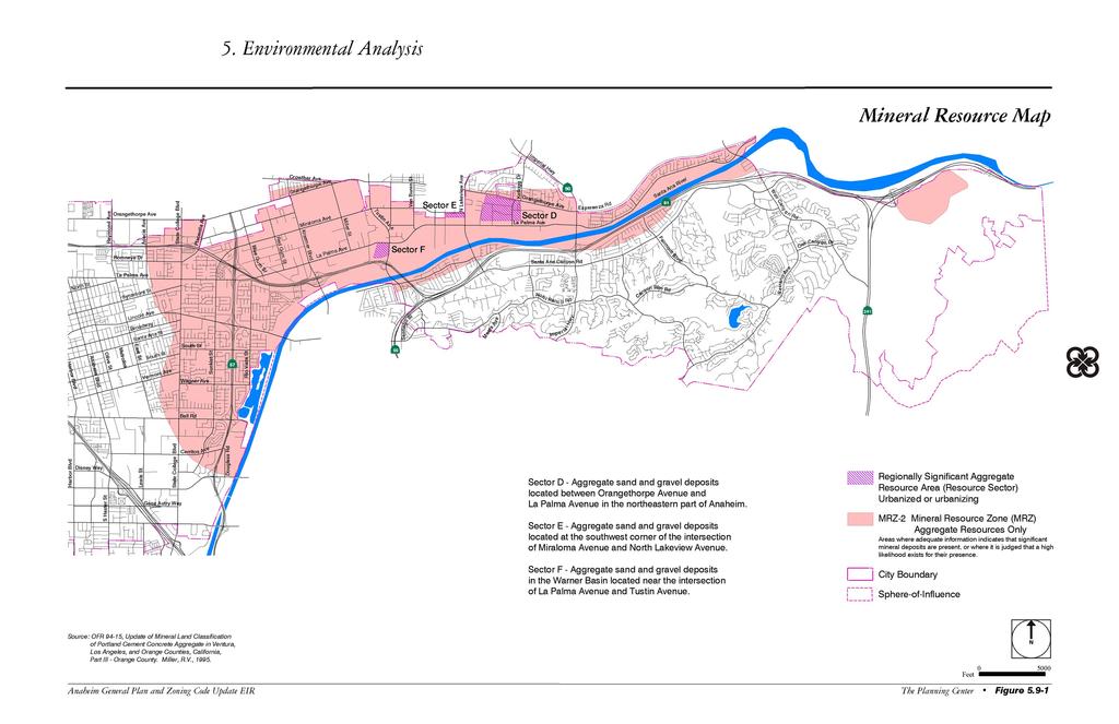
1 5.9 MINERAL RESOURCES Methodology The California Geological Survey Mineral Resources Project provides information about California s nonfuel mineral resources. The primary focus of the Mineral Resources Project is to classify lands throughout the State that contain regionally significant mineral resources as mandated by the Surface Mining and Reclamation Action of The California legislature enacted the Surface Mining and Reclamation Act (SMARA) in SMARA provides for the reclamation of mined lands and directs the State Geologist to classify (identify and map) the non-fuel mineral resources in the State to show where economically significant mineral deposits are located and where they are likely to occur based upon the best available scientific data. The Mineral Resources and Mineral Hazards Mapping Program provides data about California s non-fuel resources, naturally occurring mineral hazards, and information about active and historic mining activities throughout the State. Land classification is the principal responsibility of the Mineral Resources and Mineral Mapping Program. The non-fuel mineral resources include the metals such as gold, silver, iron and copper; the industrial minerals such as boron compounds, rare-earth elements, clays, limestone, gypsum, salt and dimension stone; and construction aggregate which includes sand and gravel, and crushed stone. The presence or absence of significant sand, gravel, or stone deposits that are suitable as sources of aggregate are classified according to areas called Mineral Resource Zones (MRZ), which are described below. The intent of classification is to assist lead agencies, planners, and the public in the wise use, management, and conservation of California s mineral resources. As California s population continues to expand, the demand for minerals-especially building construction such as aggregate-will similarly grow. MRZ-1 Mineral Resource Zone where adequate information indicates that no significant mineral deposits are present or likely to be present. MRZ-2 Mineral Resource Zone where adequate information indicates that significant mineral deposits are present, or there is a high likelihood of their presence and development should be controlled. MRZ-3 Mineral Resource Zone where the significance of mineral deposits cannot be determined from the available data. MRZ-4 Mineral Resource Zone where there is insufficient data to assign any other MRZ designation Environmental Setting Sand and gravel deposits in Anaheim are a result of the Santa Ana River, which carries alluvial material derived from a large drainage basin that encompasses parts of the San Gabriel and San Bernardino Mountains. Much of the material has been funneled through Santa Ana Canyon and deposited in the Orange County Basin. Prado Dam now prevents alluvium from being transported through the Santa Ana Canyon. The coarser alluvial material that lies in Santa Ana Canyon and within a few miles of its mouth forms a sand and gravel deposit of economic significance. According to the Mineral Resources and Mineral Hazards Mapping Program, parts of the East Anaheim, The Canyon, and Hill and Canyon Areas are identified as being within a Mineral Resource Zone, Class 2 Anaheim General Plan/Zoning Code Update EIR City of Anaheim Page 5-159
2 (MRZ-2). In addition, the City of Anaheim has three sites identified as containing mineral resources of regional significance within the Santa Ana River/Santiago Creek/Arroyo Trabuco/San Juan Creek/Temescal Valley areas of the Orange County-Temescal Valley Region, Orange, Riverside, and San Bernardino Counties. These areas are shown in Figure 5.9-1, Mineral Resource Map. It should be noted that the majority of the areas shown on Figure have already been developed Thresholds of Significance The criteria used to determine the significance of impacts on mineral resources are taken from Cityapproved Thresholds of Significance based on the City s Initial Study and the model Initial Study checklist in Appendix G of the State CEQA Guidelines. Result in the loss of availability of a known mineral resource that would be a value to the region and the residents of the state? Result in the loss of availability of a locally important mineral resource recovery site delineated on a local general plan, specific plan or other land use plan? Analysis of Environmental Impacts IMPACT: RESULT IN THE LOSS OF AVAILABILITY OF A KNOWN MINERAL RESOURCE THAT WOULD BE A VALUE TO THE REGION AND THE RESIDENTS OF THE STATE OR RESULT IN THE LOSS OF AVAILABILITY OF A LOCALLY IMPORTANT MINERAL RESOURCE RECOVERY SITE DELINEATED ON A LOCAL GENERAL PLAN, SPECIFIC PLAN OR OTHER LAND USE PLAN Impact Analysis: As shown on Figure 5.9-1, tthe State of California designates one MRZ-2 area and three specific areas of regionally significant mineral resources within the City. Changes in land use resulting from implementation of the proposed General Plan and Zoning Code Update would not significantly impact mineral resources in the MRZ-2 area or the three sites designated as regionally significant because land in this area is largely built out or already planned for development. The four sites of regionally significant mineral resources contain construction aggregate-sand and gravel and are mapped in Figure 5.9-1, Mineral Resource Map. The Robertson s Ready Mix site located in the eastern portion of the City near Gypsum Canyon is not designated as regionally significant. Extensive amounts of the sand and gravel aggregate have been removed over the past decades from the Robertson s Ready Mix site se areas and the surface for these areas and is now scheduled for permanent closure in December of The Land Use Plan designates these sites for industrial, commercial, residential, or other uses. Under Section 2764(b) of SMARA, findings must be made regarding whether the future land use is compatible or not with the existing mining operations. As stated above, the current operations in the Hill and Canyon Area (Mountain Park Specific Plan Area) are scheduled for closure in December 2004, therefore the land use designations specified in the General Plan and Zoning Code Update would not conflict with the operation of these mines. Relevant Goals and Policies Policies related to the preservation of mineral resources include: Ensure the proper reclamation of significant mineral resource zones. (Green Element, Goal 15.1, Policy 1) Page The Planning Center May 2004
3
4 This page is intentionally left blank. Page The Planning Center May 2004
5 Existing Codes and Regulations No existing codes or regulations related to groundwater apply to the proposed General Plan and Zoning Code Update. Level of Significance Before Mitigation: Less than significant. Mitigation Measures: No mitigation measures are necessary. Level of Significance After Mitigation: No significant adverse impacts were identified and no mitigation measures are necessary Significant Unavoidable Impacts There are no significant unavoidable impacts related to mineral resources. Anaheim General Plan/Zoning Code Update EIR City of Anaheim Page 5-163
6 This page intentionally left blank Page The Planning Center May 2004
5. Environmental Analysis
 5.11 This section of the Draft Environmental Impact Report (DEIR) evaluated potential impacts to mineral resources from implementation of the General Plan. 5.11.1 Environmental Setting Minerals are defined
5.11 MINERAL RESOURCES
 5.11 This section of the Draft PEIR evaluates the potential impacts to mineral resources in the Plan Area from implementation of the Clovis General Plan and Development Code Update (proposed project).
5. Environmental Analysis
 5.9 MINERAL RESOURCES This section of the EIR evaluates the potential for implementation of the City of San Bernardino General Plan Update, and the Arrowhead Springs Specific Plan to impact mineral resources
Mineral Resources
 Sacramento Local Agency Formation Commission Mineral Resources 3.11 - Mineral Resources 3.11.1 - Introduction This section describes and evaluates potential environmental impacts to mineral resources resulting
PRELIMINARY WORKING DRAFT Work in Progress
 IV. ENVIRONMENTAL IMPACT ANALYSIS H. MINERAL RESOURCES 1.0 INTRODUCTION This section addresses the potential impacts of the Proposed Project on mineral resources (i.e., sand, gravel and petroleum). The
4.12 Mineral Resources
 4.12.1 Setting Section 2.2, Project Location, provides general information about the Project s regional and local setting. This Section 4.12.1 provides setting information specific to mineral resources.
Section 4.14 Mineral Resources
 Section 4.14 Mineral Resources 4.14.1 Introduction Minerals are defined as any naturally occurring chemical elements or compounds formed from inorganic processes and organic substances. Minable minerals
The following provides summary definitions of terms relating to mineral resources:
 4.11 MINERAL RESOURCES 4.11.1 Overview This section describes the existing conditions related to mineral resources for the proposed (TRTP). The management of mineral resources is subject to numerous laws
TABLE OF CONTENTS LIST OF FIGURES. Figure : Mineral Resource Zone Map of the Proposed Project LIST OF TABLES
 TABLE OF CONTENTS 4.11 MINERAL RESOURCES... 4.11-1 4.11.0 Introduction... 4.11-1 4.11.1 Methodology... 4.11-1 4.11.2 Existing Conditions... 4.11-2 4.11.3 Impacts... 4.11-6 4.11.4 Applicants-Proposed Measures...
9. GEOLOGY, SOILS, AND MINERALS
 June 28, 2018 Page 9-1 9. GEOLOGY, SOILS, AND MINERALS This EIR chapter describes the existing geological, soil, and mineral conditions in the planning area. The chapter includes the regulatory framework
1.0 PURPOSE AND FORMAT OF THE FINAL EIR
 1.0 PURPOSE AND FORMAT OF THE FINAL EIR 1.1 PROJECT OVERVIEW CEMEX (RMC Pacific Materials, dba CEMEX) operates the Bonny Doon Shale and Limestone Quarries in Santa Cruz County for the production of Portland
5.11 Geology and Soils
 5.11 Geology and Soils 5.11 GEOLOGY AND SOILS This section evaluates the geologic and seismic conditions within the City of Azusa and evaluates the potential for geologic hazard impacts associated with
Michigan s Geology and Groundwater
 Michigan s Geology and Groundwater Ralph J. Haefner Deputy Director U.S. Geological Survey Michigan-Ohio Water Science Center Lansing, Michigan Outline About the USGS Geology 101 Michigan s geology Bedrock
4.3 CULTURAL RESOURCES
 4.3 CULTURAL RESOURCES This section of the EIR analyzes the proposed project s potential impacts on archaeological and paleontological resources. This analysis summarizes the findings of the Archaeological
City of Chino Hills General Plan Update 13GPA02 Scoping Meeting. June 4, 2013
 13GPA02 Scoping Meeting June 4, 2013 Every California city must adopt a comprehensive, long-term general plan. The General Plan is the City s constitution or blueprint for its long-range physical development.
IV. ENVIRONMENTAL IMPACT ANALYSIS E. GEOLOGY AND SOILS
 IV. ENVIRONMENTAL IMPACT ANALYSIS E. GEOLOGY AND SOILS INTRODUCTION This section evaluates potential impacts related to geology, including seismicity, and soils associated with development of the proposed
3E. Geology and Soils
 INTRODUCTION The purpose of this chapter is to evaluate the proposed project s impacts on local geological features and whether it would expose people or structures to adverse geological impacts. Potential
IV. ENVIRONMENTAL IMPACT ANALYSIS E. GEOLOGY/SOILS
 IV. ENVIRONMENTAL IMPACT ANALYSIS E. GEOLOGY/SOILS Except where otherwise noted, the following Section is based on the Preliminary Geotechnical Investigation, Proposed Medical Office Buildings and Mixed-Use
Santa Clara Valley Water District Page 1 of 4
 Santa Clara Valley Water District File No.: 16-0304 Agenda Date: 5/24/2016 Item No.: 2.7. BOARD AGENDA MEMORANDUM SUBJECT: Public Hearing and Resolution on the Decision to Become the Groundwater Sustainability
IV. ENVIRONMENTAL IMPACT ANALYSIS G. GEOLOGY AND SOILS
 IV. ENVIRONMENTAL IMPACT ANALYSIS G. GEOLOGY AND SOILS INTRODUCTION The information and analysis in this section is based primarily on the following report, which is included in Appendix IV.G of this EIR:
IV. ENVIRONMENTAL IMPACT ANALYSIS G. GEOLOGY AND SOILS
 IV. ENVIRONMENTAL IMPACT ANALYSIS G. GEOLOGY AND SOILS The following section is a summary of the geotechnical report conducted for the proposed project. The Report of Geotechnical Investigation Proposed
3.8 Mineral Resources
 Bureau of Land Management/County of Kern This section discusses mineral resources relevant to the proposed Alta East Wind Project (AEWP). The study area addressed in this section includes lands that may
3.8 Geology/Soils. Environmental Setting. Topography. Geology and Soils
 3.8 Geology/Soils This section examines whether implementation of the 2004 Land Use Mobility Elements, Zoning Code Revisions, and Central District Specific Plan the will expose people or structures to
4.5 GEOLOGY, SOILS AND SEISMICITY
 4.5 This section summarizes information on geology, soils and seismic hazards, and mineral resources in the Truckee area, as well as potential area-wide geologic hazards and regional seismic characteristics
5. Environmental Analysis
 5.3 GEOLOGY AND SOILS The potential geology and soils impacts associated with development within The Platinum Triangle have been fully analyzed in two previous EIRs, including: Anaheim Stadium Area Master
Impact : Changes to Existing Topography (Less than Significant)
") 4.2 Land Resources 4.2.1 Alternative A Proposed Action Impact 4.2.1-1: Changes to Existing Topography (Less than Significant) Development of the project site would involve grading and other earthwork as
4.2 Land Resources 4.2.1 Alternative A Proposed Action Impact 4.2.1-1: Changes to Existing Topography (Less than Significant) Development of the project site would involve grading and other earthwork as
GEOLOGY AND SOILS. This chapter summarizes geologic and geotechnical aspects of the site as they relate to the Project.
 9 GEOLOGY AND SOILS INTRODUCTION This chapter summarizes geologic and geotechnical aspects of the site as they relate to the Project. This chapter utilizes information from the following reports prepared
Influence of Paleochannels on Seepage
 Study 4 Influence of Paleochannels on Seepage Public Draft 2014 Monitoring and Analysis Plan September 2013 August 2012 Influence of Paleochannels on Seepage 1. Statement of Need Historical maps, aerial
Mineral activities within Rich County, Utah
 Natural Resources and Environmental Issues Volume 14 Bear Lake Basin Article 10 1-1-2007 Mineral activities within Rich County, Utah Patsy Palacios SJ & Jessie E Quinney Natural Resources Research Library,
DISTRICTS, MINES, AND GEOCHEMISTRY DATABASES IN NEW MEXICO. Virginia T. McLemore and Maureen Wilks
 DISTRICTS, MINES, AND GEOCHEMISTRY DATABASES IN NEW MEXICO Virginia T. McLemore and Maureen Wilks ACKNOWLEDGEMENTS New Mexico Energy, Minerals and Natural Resource Department Company annual reports Personal
4.5 GEOLOGY AND SEISMICITY
 4.5 GEOLOGY AND SEISMICITY INTRODUCTION This section identifies the potential for geologic and seismic hazards to occur on or near the proposed project site. Issues of concern include suitability of soil
Implementation of the Alquist-Priolo Earthquake Fault Zoning Act in Los Angeles County
 Implementation of the Alquist-Priolo Earthquake Fault Zoning Act in Los Angeles County Charles Nestle County of Los Angeles Dept. of Public Works Surface Fault Rupture Workshop May 10, 2013 What Work is
Appendix I-1: Archaeological Records Search
 Appendix I-1: Archaeological Records Search South Central Coastal Information Center California State University, Fullerton Department of Anthropology MH-426 800 North State College Boulevard Fullerton,
F.3 Responses to Comments Received
 Appendix F: Responses to Comments Appendix F is organized as follows: F.1 Introduction F.2 Format of the Responses to Comments: This section describes the format and organization of the comments received
IV. ENVIRONMENTAL IMPACT ANALYSIS E. GEOLOGY AND SOILS
 IV. ENVIRONMENTAL IMPACT ANALYSIS E. GEOLOGY AND SOILS The following section is a summary of the geotechnical report conducted for the Proposed Project. The Geotechnical Engineering Investigation (the
Environmental Analysis, Chapter 4 Consequences, and Mitigation
 Environmental Analysis, Chapter 4 4.17 Environmental Justice This section summarizes the potential impacts described in Chapter 3, Transportation Impacts and Mitigation, and other sections of Chapter 4,
4.6 GEOLOGY, SOILS, AND MINERAL RESOURCES
 Ascent Environmental 4.6 GEOLOGY, SOILS, AND MINERAL RESOURCES This section of the EIR describes the existing geology, soils, and mineral resources at and in the vicinity of the project site and analyzes
4.11 MINERAL RESOURCES Existing Conditions Inyo County Mineral Resource Potential
 4.11 MINERAL RESORCES 4.11.1 Existing Conditions 4.11.1.1 Inyo County Mineral Resource Potential As described in Section 4.6, the County is located within the Basin and Range Geomorphic Province, with
Cultural Resources Data
 MENIFEE VALLEY CAMPUS MASTER PLAN DRAFT EIR MT. SAN JACINTO COMMUNITY COLLEGE DISTRICT Appendices Appendix E Cultural Resources Data February 2017 MENIFEE VALLEY CAMPUS MASTER PLAN DRAFT EIR MT. SAN JACINTO
Appendix G. Summary of Hydrogeologic Conditions and Historical Mining Northwest of the Centro Subarea in the Randsburg, Red Mountain, and Atolia Area
 Appendix G Summary of Hydrogeologic Conditions and Historical Mining Northwest of the Centro Subarea in the Randsburg, Red Mountain, and Atolia Area 1.1 Background This appendix provides a summary of hydrogeologic
Groundwater Monitoring & Aggregate Operations in the Villeneuve-Calahoo Area. William Gowdy, BSc. P.Geo
 Groundwater Monitoring & Aggregate Operations in the Villeneuve-Calahoo Area William Gowdy, BSc. P.Geo Format of Talk General Background Sand and Gravel Geology & Formation of Sand and Gravel Deposits
MINERAL-RESOURCE POTENTIAL IN NEW MEXICO Virginia T. McLemore New Mexico Bureau of Geology and Mineral Resources, New Mexico Tech, Socorro, NM
 MINERAL-RESOURCE POTENTIAL IN NEW MEXICO 2018 Virginia T. McLemore New Mexico Bureau of Geology and Mineral Resources, New Mexico Tech, Socorro, NM Acknowledgements New Mexico Bureau of Geology and Mineral
5. Environmental Analysis
 5.4 This section of the Draft Environmental Impact Report (DEIR) evaluates the potential for implementation of the San Gorgonio Pass Campus Master Plan to impact geological and soil resources. The analysis
SURFACE GEOLOGY AND LIQUEFACTION SUSCEPTIBILITY IN THE INNER RIO GRANDE VALLEY NEAR ALBUQUERQUE, NEW MEXICO
 SURFACE GEOLOGY AND LIQUEFACTION SUSCEPTIBILITY IN THE INNER RIO GRANDE VALLEY NEAR ALBUQUERQUE, NEW MEXICO Keith I. Kelson, Christopher S. Hitchcock, and Carolyn E. Randolph William Lettis & Associates,
24.0 Mineral Extraction
 Chapter 24 - Mineral Extraction 24.0 Mineral Extraction 24.1 Introduction Apart from gravel, sand, rock, limestone and salt extraction in relatively small quantities mineral extraction is not a strong
Interpretive Map Series 24
 Oregon Department of Geology and Mineral Industries Interpretive Map Series 24 Geologic Hazards, and Hazard Maps, and Future Damage Estimates for Six Counties in the Mid/Southern Willamette Valley Including
Appendix 6A Geologic Information about the Project Area prepared by Ninyo & Moore October 2008
 Appendix 6A Geologic Information about the Project Area prepared by Ninyo & Moore October 2008 Appendix 6A: Geologic Information about the Project Area 6A-1Existing Geologic and Subsurface Conditions
LESSONS LEARNED FROM MINING-INFLUENCED WATERS STUDIES AT THE NEW MEXICO BUREAU OF GEOLOGY AND MINERAL RESOURCES
 LESSONS LEARNED FROM MINING-INFLUENCED WATERS STUDIES AT THE NEW MEXICO BUREAU OF GEOLOGY AND MINERAL RESOURCES Virginia T. McLemore New Mexico Bureau of Geology and Mineral Resources New Mexico Institute
5.3 GEOLOGY AND SOILS
 5.3 GEOLOGY AND SOILS SUMMARY The impact analysis presented in this section evaluates project impacts related to geologic hazards. The geotechnical analyses prepared for the project concluded that the
Chapter 7 Mudflow Analysis
 Chapter 7 Mudflow Analysis 7.0 Introduction This chapter provides information on the potential and magnitude of mud floods and mudflows that may develop in Aspen due to rainfall events, snowmelt, or rain
4.5 GEOLOGY AND SOILS
 4.5.1 Setting 4.5 GEOLOGY AND SOILS a. Regional Geology. The is located in the south central Santa Cruz Mountains in the heart of the Central Coast ranges of California. This is a seismically active region
4.11 CULTURAL RESOURCES
 4.11 CULTURAL RESOURCES 4.11 CULTURAL RESOURCES This section summarizes the cultural resources of. Information reviewed for the summary includes the General Plan, published reports on archaeological research
California s Mineral, Energy, and Soil Resources California s Water Resources California s Natural Hazards
 California s Mineral, Energy, and Soil Resources California s Water Resources California s Natural Hazards Some of the features of the California landscape formed as the result of tectonic process that
APPLICATION OF GIS DATA MODELLING FOR STONE AGGREGATE POTENTIAL IN DALMATIA
 APPLICATION OF GIS DATA MODELLING FOR STONE AGGREGATE POTENTIAL IN DALMATIA Željko Dedić (1) Ozren Hasan (1) Slobodan Miko (1) Boris Lukšić (1) Erli Kovačević (1) (1) Croatian Geological Survey; Sachsova
Do Now - APES. Due Next Class. Mining HW. Work on QSC using today s notes
 Do Now - APES 1. Grab a chromebook 2. Log on to Albert.io & work on The Living World Loss of Biodiversity Soil & Soil Dynamics Fishing (10min) Mining HW Due Next Class Work on QSC using today s notes Do
Heather Schlosser Army Corps of Engineers Coastal Studies Group August 28, 2008
 Got sand? Regional Sediment Management in Orange County Heather Schlosser Army Corps of Engineers Coastal Studies Group August 28, 2008 Regional Sediment Management Regional sediment management recognizes
Roy Pyle March 24, 2017 Chief Facilities Planner Contra Costa Community College District 500 North Court Street Martinez, CA 94533
 State of California Natural Resources Agency Edmund G. Brown Jr., Governor Department of Conservation John G. Parrish, Ph.D., State Geologist California Geological Survey 801 K Street MS 12-31 Sacramento,
Tucson Geologic History: Cenozoic ( Ma (million years ago)) Dr. Jan C. Rasmussen
) Dr. Jan C. Rasmussen") Tucson Geologic History: Cenozoic (65.5 0 Ma (million years ago)) Dr. Jan C. Rasmussen www.janrasmussen.com Temp. & Geologic Time Scale 4.6 Ga Tertiary 65-0 Ma Orogenies (mountain building) Cenozoic Formations
Tucson Geologic History: Cenozoic (65.5 0 Ma (million years ago)) Dr. Jan C. Rasmussen www.janrasmussen.com Temp. & Geologic Time Scale 4.6 Ga Tertiary 65-0 Ma Orogenies (mountain building) Cenozoic Formations
Earthquake Hazards in Henderson
 Earthquake Hazards in Henderson Craig M. depolo Nevada Bureau of Mines and Geology Nevada Hazard Mitigation Planning Committee November 15, 2012 Earthquake Truths The consequences of bad earthquakes to
Chapter 7 Mudflow Analysis
 Chapter 7 Mudflow Analysis 7.0 Introduction This chapter provides information on the potential and magnitude of mud floods and mudflows that may develop in Aspen due to rainfall events, snowmelt, or rain
EROSION, DEPOSITION AND SEDIMENTARY ROCKS. Reading: Earth Science Tarbuck and Lutgens Chapter 5: pages Chapter 3: pages 52-54, 61-69
 EROSION, DEPOSITION AND SEDIMENTARY ROCKS Reading: Earth Science Tarbuck and Lutgens Chapter 5: pages 124-133 Chapter 3: pages 52-54, 61-69 Base Level Resistant bed Resistant bed creates a local base level
C.Y. Geotech, Inc. Soil Engineering Investigation Victory Boulevard, Van Nuys, California. August 31, Ibid.
 E. SOILS AND GEOLOGY The purpose of this section is to assess impacts related to geologic resources resulting from construction and development of the proposed project and adjacent Add Area, such as seismically
4.5 GEOLOGY AND SOILS
 4.5 GEOLOGY AND SOILS This section addresses the project site geology and soils and analyzes potential changes that would result from development of the Wye Specific Plan project. 4.5.1 Environmental Setting
Stanislaus County Water Advisory Committee. May 30, 2018
 Stanislaus County Water Advisory Committee May 30, 2018 2018 Hydrologic Conditions and Water Supply Outlook 2018 Water Allocations WEST Federal 45% State 35% CCID 100% EAST SSJID 100% OID
West Hollywood General Plan
 ITEM 2.RR. EXHIBIT B Providing a safe living environment is a fundamental goal and one of the most important challenges cities face today. Anticipating, planning for, and guarding against threats to public
Cretaceous, Dakota Formation, Terra Cotta Member South Side of I-70, Salina County, Kansas
 Cretaceous, Dakota Formation, Terra Cotta Member South Side of I-70, Salina County, Kansas Written By: Steven D.J. Baumann G-102010-1A Outcrop looking southeast Photo taken by: Steven Baumann on 10-20-2010
Tell me what the word aggregate means and at least three things aggregate is used to make.
 Lesson Plan Scout s Geology Objective: After today s lesson, you will be able to Tell me what the word aggregate means and at least three things aggregate is used to make. List the steps in the mining
The role of the Competent Person. Neil Wells, CRIRSCO Deputy Chair, Yogyakarta, 31 October 2017
 The role of the Competent Person Neil Wells, CRIRSCO Deputy Chair, Yogyakarta, 31 October 2017 Why are Competent Persons needed for reporting? Mineral commodities and occurrences are diverse Copper (disseminated,
3.6 GEOLOGY, SOILS, AND MINERAL RESOURCES
 3.6 GEOLOGY, SOILS, AND MINERAL RESOURCES This section of the draft EIR discusses the geologic, soil, and mineral resources conditions of the planning area and identifies the related potential environmental
Geologic Setting and History of Mining in the Animas River Watershed, southern Colorado
 Geologic Setting and History of Mining in the Animas River Watershed, southern Colorado Virginia T. McLemore New Mexico Bureau of Geology and Mineral Resources, New Mexico Tech, Socorro, NM On August 5,
IV. ENVIRONMENTAL IMPACT ANALYSIS E. GEOLOGY AND SOILS
 IV. ENVIRONMENTAL IMPACT ANALYSIS E. GEOLOGY AND SOILS The following analysis is based on the Geotechnical Investigation Report, Proposed Mid-Rise Multi- Family Residential Development Project Wetherly
Seismic Geotechnical Hazard Zonation Of Geological Factors
 1 st Workshop of M.E.E.T.I.N.G Project Seismic Geotechnical Hazard Zonation Of Geological Factors Maja Oštri, dipl.ing.geol Dubrovnik, March 3rd-4th 2008 SUBJECT OF THE INVESTIGATION? Geological Factors
COMMUNITY DEVELOPMENT DEPARTMENT POLICY & PROCEDURE
 COMMUNITY DEVELOPMENT DEPARTMENT POLICY & PROCEDURE Policy No: DSP-OO3 Release Date: January 1, 2014 Effective Date: January 1, 2014 Revision Date: March 1, 2018 TITLE: The City Policy for Site Specific
Be located on expansive soil, as defined in Table 18-1-B of the Uniform Building Code (1994), creating substantial risks to life or property.
, creating substantial risks to life or property.") Lower Putah Creek Restoration Project Upper Reach Program 3.3 GEOLOGY AND SOILS, AND MINERAL RESOURCES 3.3 GEOLOGY AND SOILS, AND MINERAL RESOURCES This section describes existing soils and geologic conditions
Lower Putah Creek Restoration Project Upper Reach Program 3.3 GEOLOGY AND SOILS, AND MINERAL RESOURCES 3.3 GEOLOGY AND SOILS, AND MINERAL RESOURCES This section describes existing soils and geologic conditions
patersongroup Mineral Aggregate Assessment 3119 Carp Road Ottawa, Ontario Prepared For Mr. Greg LeBlanc March 7, 2014 Report: PH2223-REP.
 Geotechnical Engineering Environmental Engineering group Hydrogeology Geological Engineering Archaeological Studies Materials Testing 3119 Carp Road Prepared For Mr. Greg LeBlanc March 7, 2014 Paterson
B. T. Brady, M. S. Bedinger, John Mikels, William H. Langer, and Deborah A. Mulvihill
 DEPARTMENT OF THE INTERIOR UNITED STATES GEOLOGICAL SURVEY TO ACCOMPANY WRI REPORT 83-4121-B MAP SHOWING GROUND-WATER LEVELS, SPRINGS. AND DEPTH TO GROUND WATER, BASIN AND RANGE PROVINCE, TEXAS by B. T.
Requirements for a Dark Skies Designation RLEP
 Requirements for a Dark Skies Designation RLEP 2017 Why Consider a Dark Skies Designation? Demonstrates a public commitment to preserving the quality of night skies Is a valuable credential for promoting
Landscape Analysis of Mineral Resources A View from Home Tree ( Avatar )
") NRC Workshop on Landscape Approaches and Multi-Resource Analysis for Sustainable Natural Resource Management: June 2, 2015 Landscape Analysis of Mineral Resources A View from Home Tree ( Avatar ) Murray
NRC Workshop on Landscape Approaches and Multi-Resource Analysis for Sustainable Natural Resource Management: June 2, 2015 Landscape Analysis of Mineral Resources A View from Home Tree ( Avatar ) Murray
Mark S. Nordberg Geology and Groundwater Investigations Section North Central Region Office California Department of Water Resources
 Mark S. Nordberg Geology and Groundwater Investigations Section North Central Region Office California Department of Water Resources Ukiah Drought Workshop July 29, 2009 Groundwater 101 Groundwater is
Setting MOUNTAIN HOUSE NEIGHBORHOODS I AND J INITIAL STUDY 5. ENVIRONMENTAL CHECKLIST 6. GEOLOGY AND SOILS. Issue
 Issue Less Than Significant or No Impact Potential Significant Impact Adequately Addressed in MEIR MEIR Required Additional Review: No Significant Impact Less Than Significant Impact Due to Mitigation
Geology, Soils, and Seismicity
 Section 3.8 Geology, Soils, and Seismicity Introduction This section generally evaluates the effects of the alternatives analyzed in this Supplemental DEIS with regard to geology, soils and seismicity.
CEMEX Eliot Quarry. Lake A Evaluation Report. Alameda County, California
 May 7, 2015 May 7, 2015 Project No. GT13-16 Prepared for: CEMEX 5180 Golden Foothills, Parkway El Dorado Hills, California 95762 7400 Shoreline Drive, Ste. 6 Stockton, California 95219 Tel: 209-472-1822
Carrapateena Mineral Resources Explanatory Notes April OZ Minerals Limited. Carrapateena Mineral Resources Statement April
 OZ Minerals Limited Carrapateena Mineral Resources Statement April 14 2011 CARRAPATEENA MINERAL RESOURCE STATEMENT April 14, 2011 The Carrapateena Resource Statement relates to an upgrading to an Inferred
WHAT IS A ROCK? Granite. Muscovite. Orthoclase. Quartz. Feldspar. Biotite
 Mining, Jobs October 2014 WHAT IS A ROCK? A ROCK IS DEFINED AS AN COMBINATION OF ONE OR MORE MINERALS. Granite Orthoclase Muscovite Feldspar Quartz Biotite What Makes One Rock Better than Another Rock?
3.3 GEOLOGY AND SOILS Environmental Setting Geologic Conditions
 3.3 GEOLOGY AND SOILS This section describes existing geologic and soil conditions, such as faults or unstable soils, and analyzes potential impacts that could pose hazards for the Fountain Valley Crossings
Aggregate planning in Emilia-Romagna Region methods and data
 Aggregate planning in Emilia-Romagna Region methods and data Stakeholder consultation, SNAP-SEE project Zagreb (HR), 25 th October 2013 Christian Marasmi, Massimo Romagnoli, Anna Rita Rizzati Emilia-Romagna
GEOLOGY, SOILS, AND SEISMICITY / MINERAL RESOURCES
 4.6 GEOLOGY, SOILS, AND SEISMICITY / MINERAL RESOURCES 4.6.1 INTRODUCTION The Geology, Soils, and Seismicity / Mineral Resources chapter of the Draft EIR describes the geologic and soil characteristics
4.4 GEOLOGY AND SOILS
 4.4 GEOLOGY AND SOILS SUMMARY This section describes the existing geologic and soils conditions on the project site, and the potential for geotechnical hazards to affect the Via Princessa East Extension
Energy and Mineral Resources
 1 Energy and Mineral Resources 2 3 4 5 6 7 8 9 10 11 12 13 14 15 16 17 18 19 Earth 9 th Edition Chapter 23 Energy & Mineral Resources: summary in haiku form Petroleum, gas, coal, uranium, et al. There's
Florida s Karst Geology
 Florida s Karst Geology Orange Creek Basin Interagency Working Group Public Workshop, November 5 th, 2015 Harley Means, P.G. Assistant State Geologist Florida Geological Survey Karst Karst a type of topography
 Red River Flooding June 2015 Caddo and Bossier Parishes Presented by: Flood Technical Committee Where the Rain Falls Matters I-30 versus I-20 I-20 Backwater and Tributary Floods (Localized) 2016 Flood
Flash flood disaster in Bayangol district, Ulaanbaatar
 Flash flood disaster in Bayangol district, Ulaanbaatar Advanced Training Workshop on Reservoir Sedimentation Management 10-16 October 2007. IRTCES, Beijing China Janchivdorj.L, Institute of Geoecology,MAS
3.9 GEOLOGY, SOILS, AND MINERALS
 3.9 GEOLOGY, SOILS, AND MINERALS 3.9.1 INTRODUCTION This section covers three closely related topics: geology (including geologic hazards such as earthquakes), soils, and mineral resources. For each of
4.L GEOLOGY, SOILS, AND SEISMICITY 4.L.1 INTRODUCTION
 4.L GEOLOGY, SOILS, AND SEISMICITY 4.L.1 INTRODUCTION This section addresses potential environmental effects of the proposed TOD Plan for Downtown Inglewood and Fairview Heights related to geology, soils,
APPENDIX 3B OCCURRENCE OF SIGNIFICANT RIVER ALLUVIUM AQUIFERS IN THE PLATEAU REGION
 Plateau Region Water Plan January 2011 APPENDIX 3B OCCURRENCE OF SIGNIFICANT RIVER ALLUVIUM AQUIFERS IN THE PLATEAU REGION Occurrence of Significant River Alluvium Aquifers in the Plateau Region Prepared
2.10 Geology/Soils/Seismic/Topography
 2.10 Geology/Soils/Seismic/Topography 2.10.1 Regulatory Setting This section discusses geology, soils, and seismic concerns as they relate to public safety and project design. Earthquakes are prime considerations
 BPC Policy No , IIM7fyilK Office of the District Clerk TRANSITION ZONE POLICY")
Great Lakes Tributary Modeling: Canaseraga Creek Watershed
 Great Lakes Tributary Modeling: Canaseraga Creek Watershed SWAT Model Authority: Section 516(e) of WRDA 1996 US Army Corps of Engineers Canaseraga Creek Project Location - Encompasses portions of Livingston,
TABLE OF CONTENTS ARTICLE I. POLK COUNTY COMPREHENSIVE PLAN VOLUME 1. Page CHAPTER 1. GENERAL... A-1
 TABLE OF CONTENTS ARTICLE I. POLK COUNTY COMPREHENSIVE PLAN VOLUME 1 Page CHAPTER 1. GENERAL... A-1 DIVISION 1.100 GENERAL PROVISIONS... A-1 DIVISION 1.200 BASIC PRINCIPLES... A-6 DIVISION 1.300 THE PLANNING
Tuesday 6 June 2017 Afternoon
 Oxford Cambridge and RSA Tuesday 6 June 2017 Afternoon A2 GCE GEOLOGY F794/01 Environmental Geology *6783378785* Candidates answer on the Question Paper. OCR supplied materials: None Other materials required: