CEMEX Eliot Quarry. Lake A Evaluation Report. Alameda County, California
|
|
|
- Nicholas Johnston
- 5 years ago
- Views:
Transcription

1 May 7, 2015
2
3 May 7, 2015 Project No. GT13-16 Prepared for: CEMEX 5180 Golden Foothills, Parkway El Dorado Hills, California Shoreline Drive, Ste. 6 Stockton, California Tel: Fax:
4 THIS PAGE INTENTIONALLY LEFT BLANK ii
5 TABLE OF CONTENTS TABLE OF CONTENTS iii 1. INTRODUCTION General Purpose SLOPE STABILITY ANALYSES Lake A Slope Stability Analyses Geologic Model Lake A, Profile A Lake A, Profile B Lake A, Profile C Lake A, Profile D Lake A Slope Stability Results CONCLUSIONS AND RECOMMENDATIONS REFERENCE LIMITATIONS APPENDIX A Slope Stability Analysis Profile A Static Analysis Seismic Analysis APPENDIX B Slope Stability Analysis Profile B Static Analysis Seismic Analysis APPENDIX C Slope Stability Analysis Profile C Static Analysis Seismic Analysis APPENDIX D Slope Stability Analysis Profile D Static Analysis Seismic Analysis APPENDIX E Slope Stability Analysis Profile D (After Grading) iii
6 THIS PAGE INTENTIONALLY LEFT BLANK iv
 was contracted by CEMEX, Inc. (CEMEX) to assess the slope stability of Lake A located in Livermore, California in Alameda County.")

7 7400 Shoreline Drive, Stockton, California Suite Phone Fax william.kane@kanegeotech.com 1441 Kapiolani Boulevard Suite 1115 Honolulu, Hawaii INTRODUCTION 1.1 General (KANE GeoTech) was contracted by CEMEX, Inc. (CEMEX) to assess the slope stability of Lake A located in Livermore, California in Alameda County. Lake A is presently an inactive quarry that will eventually be the first link in the Chain of Lakes proposed by Alameda County Flood Control and Water Conservation District, Zone 7, Figure 1. The slope stability analysis of Lake A has been prepared to support the Reclamation Plan Amendment that CEMEX has submitted to Alameda County. Additional mining will not occur within Lake A. However, the reclamation of Lake A for use in the Chain of Lakes will include limited additional excavation in some areas and filling or grading of other areas. The geologic model, material properties, and seismic coefficients used in this evaluation report for Lake A are based on the information and interpretations presented in the accompanying Geotechnical Characterization Report and its Figure 1. Overview of Chain of Lakes

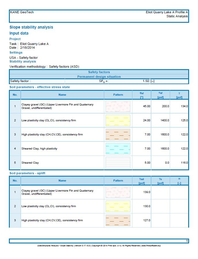
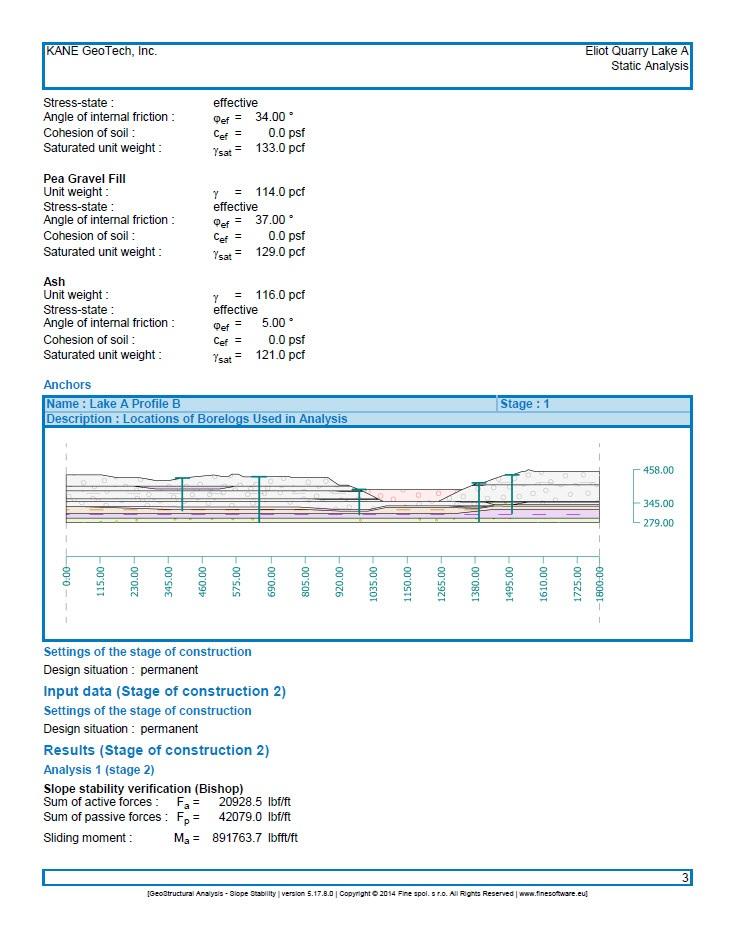
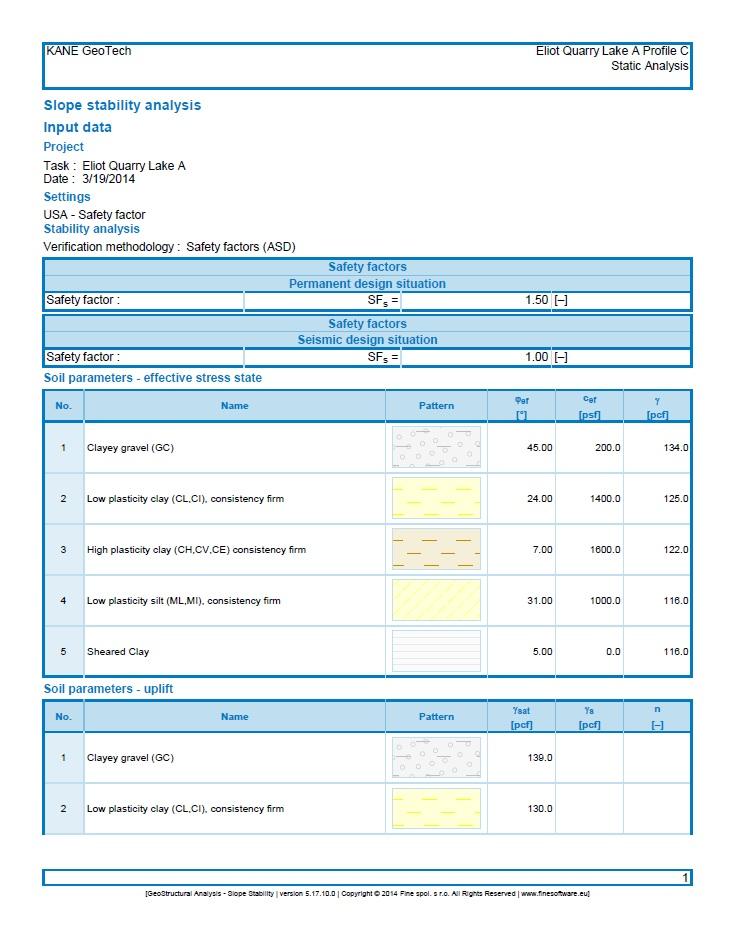
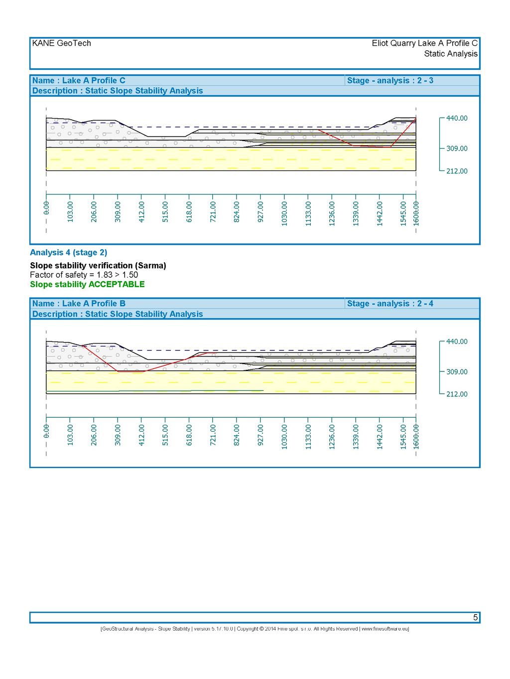
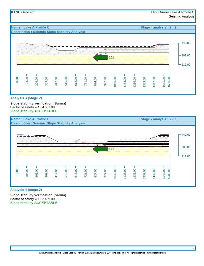
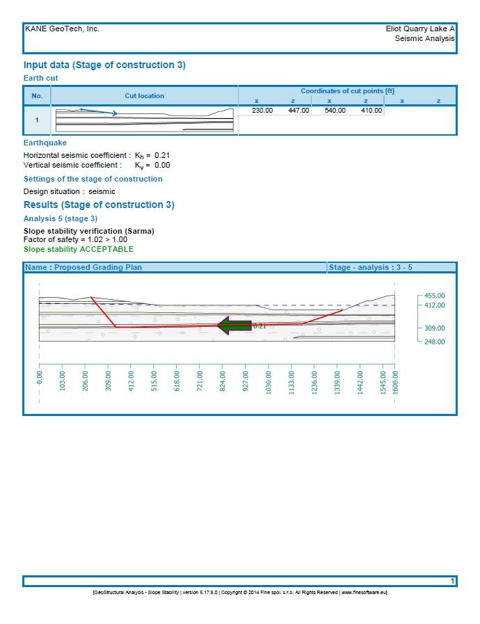
8 Page 2 supporting Appendices, which contain additional site background and information. Summaries of pertinent references and complete methodologies for analyses can also be found in the Geotechnical Characterization Report. 1.2 Purpose The purpose of this report is to describe the results of the slope stability analyses, for Lake A, performed as part of the permitting requirements for Eliot Quarry. 2. SLOPE STABILITY ANALYSES 2.1 Lake A Slope Stability Analyses A total of four profiles were constructed and analyzed, Profiles A-D, Figure 2. Worst case scenarios were modeled, with the pit being completely empty and the slopes fully saturated with groundwater. For the seismic analyses, a seismic coefficient of 0.21 was used, as described in Section 4.5 of the Geotechnical Characterization Report. This coefficient value is considered quite conservative, or protective of surrounding properties, as discussed in more detail in the Geotechnical Characterization Report. Material properties are given in Table 1. Figure 2. Overview of Lake A cross section profiles
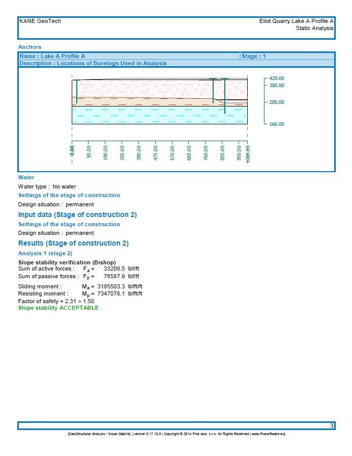
9 Page Geologic Model Following a review of available materials and a geotechnical investigation, a geologic model was constructed by KANE GeoTech. This geologic model shows the Livermore Valley s depositional environment being an alluvial system rather than the lacustrine deposit as proposed by CSA. The difference is an alluvial environment would result in discontinuous layers and a lacustrine environment has laterally continuous layers. KANE GeoTech conservatively modeled areas with continuous layers where drilling logs were unable to show otherwise to reflect CSA s geologic model. Borings locations are shown in the Geotechnical Characterization Appendix document. Material parameters for each profile are found in Table Lake A, Profile A. Data from three borelogs were used in the construction of Profile A. These borelogs show the discontinuity of the layers on the northern area of Profile A Lake A, Profile B. Data from five borelogs were used in the construction of Profile B. These borelogs also show layers of discontinuity throughout the Profile area Lake A, Profile C. Data from two borelogs were used in the construction of Profile C. These borelogs also reflect discontinuous layers in the northern area of the Profile. Due to the lack of data in the center of the Lake A in this area, the discontinuous layers were conservatively modeled to continue half way between the borelogs Lake A, Profile D. Data from three borelogs were used in the construction of Profile D. These borelogs show discontinuity in the northern area as well. Due to the lack of data in the center of Lake A, the low TABLE 1: TYPICAL MATERIAL PARAMETERS USED IN THE ANALYSES Profile Material Parameters Avg. Unit Weight (pcf) Saturated Unit Weight (pcf) Cohesion (psf) Friction Angle (Deg) A, B, C, D Clayey Gravel A, B, C, D Low Plasticity Clay B, C Low Plasticity Silt A, B, C, D High Plasticity Clay B Well Graded Sand B Pea Gravel Fill A, D Sheared Clay, high plasticity
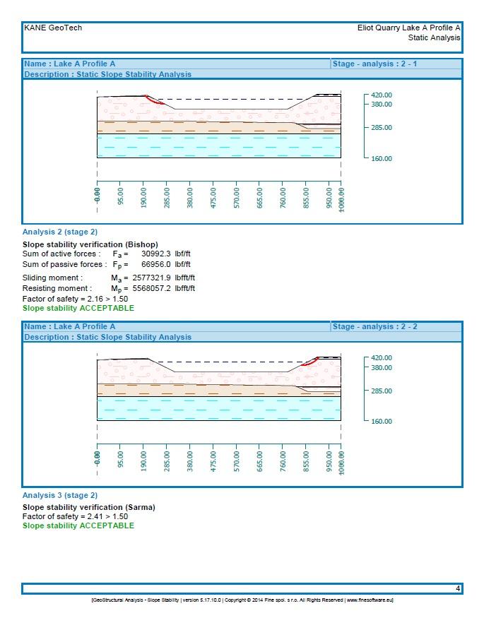
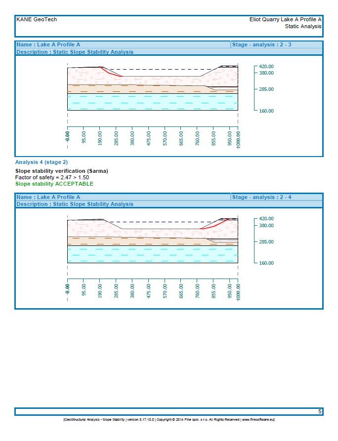
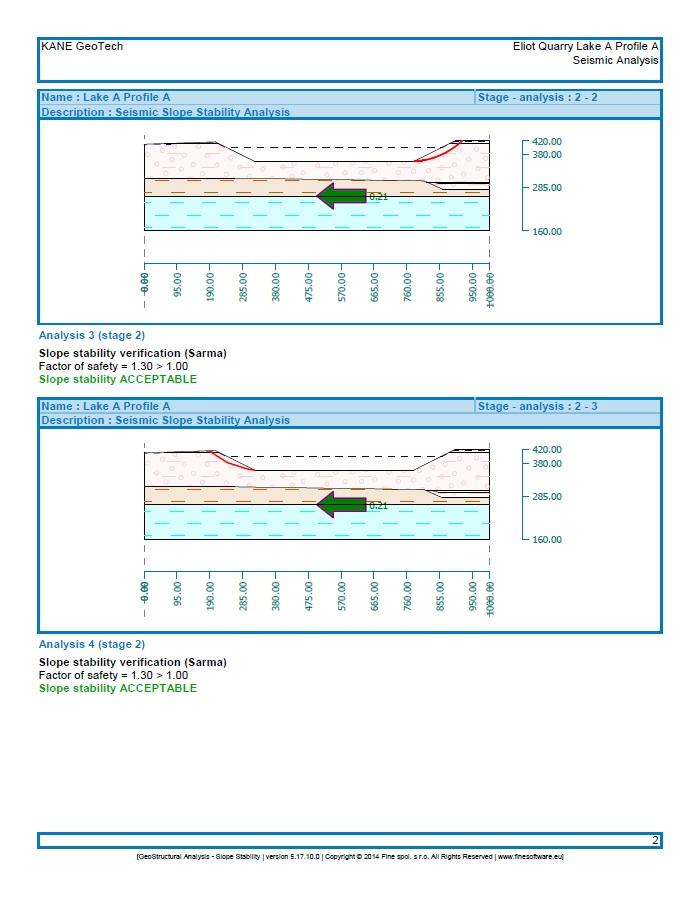
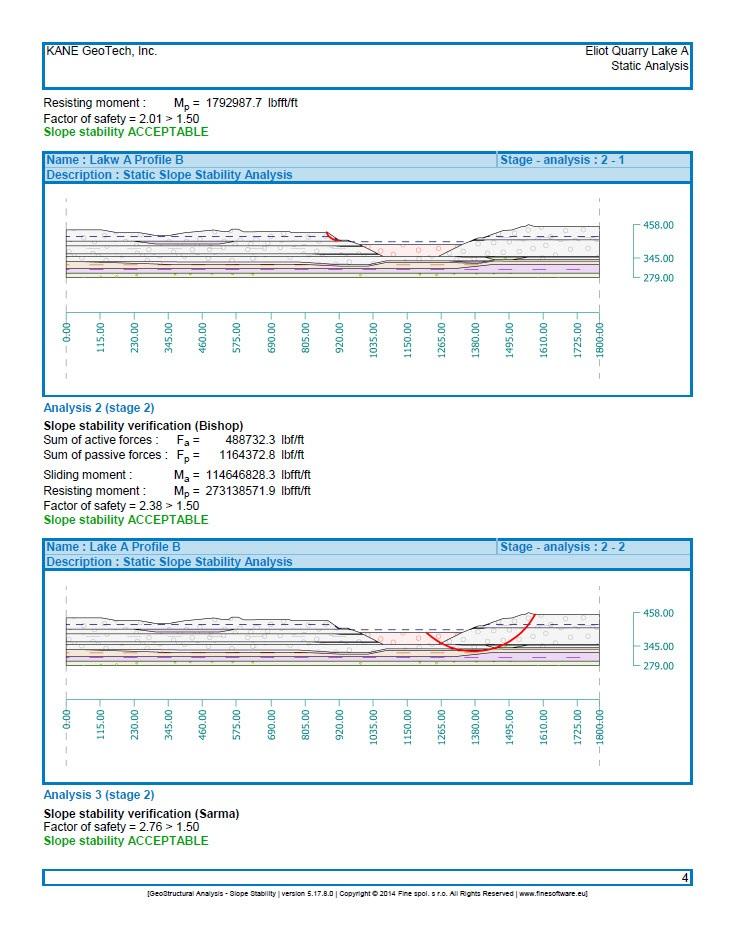
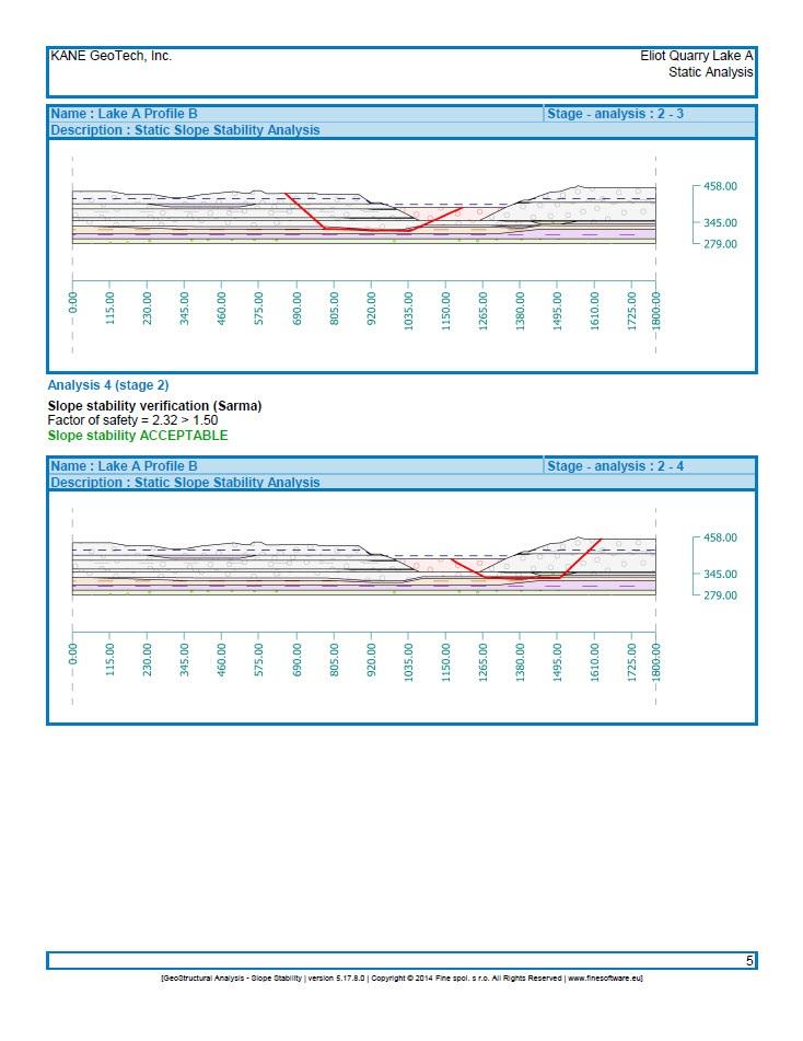
10 Page 4 plasticity clay layers were conservatively modeled as continuous layers with a change in elevation, although, it is most likely the elevation change is due to the layers being discontinuous. 2.3 Lake A Slope Stability Results The analyzed profiles and results of the static and seismic slope stability analyses for Lake A can be found in Figure 2, Table 2, and Appendix A. Four profiles throughout Lake A were modeled and analyzed statically and seismically at various mining elevations with a 2H:1V slope gradient. Subsequent to the initiation of this investigation, CEMEX determined that Lake A will no longer be mined to the originally proposed elevations. Analyses showed that the slopes in Lake A are stable under static conditions. Profiles A, B, and C, Appendix A, are stable in both static and seismic conditions. The analyses of Profile D indicated that the slopes were stable under static conditions, but when modeled under seismic conditions the resulting safety factor of 0.98 did not meet the required value of 1.0 at the proposed pit depth, Appendix D; however under the revised grading plan the safety factor increased to 1.02, Appendix E. The slope was re-analyzed with a TABLE 2. SLOPE STABILITY ANALYSES RESULTS Lake A Profile A - Filled with Water Circular Failure SE Slope Circular Failure NW Slope Block Failure SE Slope Block Failure NW Slope FOS (Static) FOS (Seismic) Lake A Profile B -Filled with Water Circular Failure SE Slope Circular Failure NW Slope Block Failure SE Slope Block Failure NW Slope FOS (Static) FOS (Seismic) Lake A Profile C - Filled with Water Circular Failure SE Slope Circular Failure NW Slope Block Failure SE Slope Block Failure NW Slope FOS (Static) FOS (Seismic) Lake A Profile D - Filled with Water (as is) Circular Failure NW Slope Circular Failure SE Slope Block Failure SE Slope Block Failure NW Slope FOS (Static) FOS (Seismic)* *See text, Section 2.3
11 Page 5 new, proposed grading profile which modeled the slope as stable under seismic conditions. The grading profile can also be found in Appendix E. Profile A, located on the west slope adjacent to Isabel Avenue, was analyzed and modeled with a pit elevation of 360-ft MSL. This slope is the proposed location of the conveyance pipe that will link Lake A to the planned chain of lakes. The slope met the required safety factors and is considered stable when excavated to 360-ft MSL. 3. CONCLUSIONS AND RECOMMENDATIONS After performing the static and seismic slope stability analyses for Lake A, our conclusions are as follows: 1. It has been determined that Lake A will no longer be mined. The slopes were modeled under currently existing configurations, and all were stable statically and seismically with the exception of Profile D under seismic conditions. This slope was reanalyzed with a new grading plan and modeled stable under seismic conditions. The slope where the proposed conveyance pipe is located was modeled at the conveyance pipe elevation 360-ft MSL and was stable statically and seismically. 2. Elastic rebound of the slopes after mining should be expected. It should be noted that CSA (2009) stated that elastic rebound of Lake A slopes had occurred due to stress relief. Modeling conducted for this study shows that all slopes are stable, including those adjacent to the corrective action area (i.e. pea gravel buttress). 3. The sheared clay layer found in Lake A boreholes is not continuous. CSA s geologic model showed that the weak sheared clay layer is continuous. However based on observations made from KANE GeoTech s 2013 borelogs the sheared clay layer is not ubiquitous at Lake A. 4. REFERENCE Cotton, Shires, & Associates, Inc. (2009). As-Built Report and Summary of Construction Inspection and Testing, Lakeside Circle Corrective Action Plan,. Report to CEMEX, Eldorado Hills, California by Cotton, Shires, and Associates, Inc., Los Gatos, California, December 23, LIMITATIONS The analyses, conclusions and recommendations contained in this report are based on the site conditions observed by KANE GeoTech and derived from the information provided. If there is a substantial lapse of time between the submission of this report and the start of any work at the site, or field conditions have changed due to natural causes, mining, or construction operations at or adjacent to the site, we urge that this report be reviewed to determine the applicability of the conclusions and recommendations considering the changed conditions and time lapse. This report is applicable only for the project and sites studied. After three years, KANE GeoTech should be consulted if this report is used to make any decisions regarding the area.

12 Page 6 Our professional services were performed, our findings obtained, and our recommendations proposed in accordance with generally accepted engineering principles and practices. This warranty is in lieu of all other warranties either expressed or implied. Findings and statements of professional opinion do not constitute a guarantee or warranty, expressed or implied. William F. Kane, PhD, PE President California Registered Civil Engineer No
13 Page 7 APPENDIX A Slope Stability Analysis Profile A
14 Page 8 THIS PAGE INTENTIONALLY LEFT BLANK
15 Page 9 Static Analysis
16 Page 10 THIS PAGE INTENTIONALLY LEFT BLANK
17 Page 11
18 Page 12
19 Page 13
20 Page 14
21 Page 15
22 Page 16 THIS PAGE INTENTIONALLY LEFT BLANK
23 Page 17 Seismic Analysis
24 Page 18 THIS PAGE INTENTIONALLY LEFT BLANK

25 Page 19
26 Page 20
27 Page 21
28 Page 22 THIS PAGE INTENTIONALLY LEFT BLANK
29 Page 23 APPENDIX B Slope Stability Analysis Profile B
30 Page 24 THIS PAGE INTENTIONALLY LEFT BLANK
31 Page 25 Static Analysis
32 Page 26 THIS PAGE INTENTIONALLY LEFT BLANK

33 Page 27

34 Page 28
35 Page 29
36 Page 30
37 Page 31
38 Page 32 THIS PAGE INTENTIONALLY LEFT BLANK
39 Page 33 Seismic Analysis
40 Page 34 THIS PAGE INTENTIONALLY LEFT BLANK
41 Page 35
42 Page 36
43 Page 37
44 Page 38 THIS PAGE LEFT INTENTIONALLY BLANK
45 Page 39 APPENDIX C Slope Stability Analysis Profile C
46 Page 40 THIS PAGE INTENTIONALLY LEFT BLANK
47 Page 41 Static Analysis
48 Page 42 THIS PAGE INTENTIONALLY LEFT BLANK
49 Page 43
50 Page 44
51 Page 45
52 Page 46
53 Page 47
54 Page 48
55 Page 49
56 Page 50 THIS PAGE INTENTIONALLY LEFT BLANK
57 Page 51 Seismic Analysis
58 Page 52 THIS PAGE INTENTIONALLY LEFT BLANK
59 Page 53
60 Page 54
61 Page 55
62 Page 56 THIS PAGE INTENTIONALLY LEFT BLANK
63 Page 57 APPENDIX D Slope Stability Analysis Profile D
64 Page 58 THIS PAGE LEFT INTENTIONALLY BLANK
65 Page 59 Static Analysis
66 Page 60 THIS PAGE INTENTIONALLY LEFT BLANK

67 Page 61
68 Page 62
69 Page 63

70 Page 64

71 Page 65

72 Page 66
73 Page 67
74 Page 68 THIS PAGE INTENTIONALLY LEFT BLANK
75 Page 69 Seismic Analysis
76 Page 70 THIS PAGE INTENTIONALLY LEFT BLANK
77 Page 71

78 Page 72

79 Page 73

80 Page 74
81 Page 75
82 Page 76 THIS PAGE INTENTIONALLY LEFT BLANK
83 Page 77 APPENDIX E Slope Stability Analysis Profile D (After Grading)
84 Page 78 THIS PAGE LEFT INTENTIONALLY BLANK
85 Page 79
86 Page 80 THIS PAGE INTENTIONALLY LEFT BLANK
CEMEX Eliot Quarry. Geotechnical Characterization Report. Alameda County, California
 May 7, 2015 May 7, 2015 Project No. GT13-16 Prepared for: CEMEX 5180 Golden Foothills, Parkway El Dorado Hills, California 95762 7400 Shoreline Drive, Ste. 6 Stockton, California 95219 Tel: 209-472-1822
IV. ENVIRONMENTAL IMPACT ANALYSIS G. GEOLOGY AND SOILS
 IV. ENVIRONMENTAL IMPACT ANALYSIS G. GEOLOGY AND SOILS The following section is a summary of the geotechnical report conducted for the proposed project. The Report of Geotechnical Investigation Proposed
Date: April 2, 2014 Project No.: Prepared For: Mr. Adam Kates CLASSIC COMMUNITIES 1068 E. Meadow Circle Palo Alto, California 94303
 City of Newark - 36120 Ruschin Drive Project Draft Initial Study/Mitigated Negative Declaration Appendix C: Geologic Information FirstCarbon Solutions H:\Client (PN-JN)\4554\45540001\ISMND\45540001 36120
Slope Stability Evaluation Ground Anchor Construction Area White Point Landslide San Pedro District Los Angeles, California.
 Slope Stability Evaluation Ground Anchor Construction Area White Point Landslide San Pedro District Los Angeles, California Submitted To: Mr. Gene Edwards City of Los Angeles Department of Public Works
APPENDIX 1. Geotechnical Information and Analysis. Pacific Aggregates Inc. and Pacific Clay Products July 13, 2011 RP112 Reclamation Plan
 Pacific Aggregates Inc. and Pacific Clay Products July 13, 2011 RP112 Reclamation Plan APPENDIX 1 Geotechnical Information and Analysis PA02_RP112-RecPlan-Resub_FNL.docx SESPE Consulting, Inc. June 27,
patersongroup Consulting Engineers April 20, 2010 File: PG1887-LET.01R Novatech Engineering Consultants Suite 200, 240 Michael Cowpland Drive
 patersongroup April 20, 2010 File: PG1887-LET.01R Novatech Engineering Consultants Suite 200, 240 Michael Cowpland Drive Ottawa, Ontario K2M 1P6 Attention: Mr. Adam Thompson Consulting Engineers 28 Concourse
GEOSYNTEC CONSULTANTS
 GEOSYNTEC CONSULTANTS 2100 Main Street, Suite 150 Huntington Beach, CA 92648 USA Tel (714) 969-0800 Fax (714) 969-0820 15 February 2006 Ms. Tamara Zeier, P.E. Project Manager Project Navigator, Ltd. One
Central Queensland Coal Project Appendix 4b Geotechnical Assessment. Environmental Impact Statement
 Central Queensland Coal Project Appendix 4b Geotechnical Assessment Environmental Impact Statement GEOTECHNICAL ASSESSMENT OF OPEN CUT MINING ADJACENT TO THE BRUCE HIGHWAY, CENTRAL QUEENSLAND COAL PROJECT
SLOPE STABILITY EVALUATION AND ACCEPTANCE STANDARDS
 INFORMATION BULLETIN / PUBLIC - BUILDING CODE REFERENCE NO.: LAMC 98.0508 Effective: 1-26-84 DOCUMENT NO. P/BC 2002-049 Revised: 11-1-02 Previously Issued As: RGA #1-84 SLOPE STABILITY EVALUATION AND ACCEPTANCE
NOA ASSESSMENT HARRIS QUARRY MENDOCINO COUNTY, CALIFORNIA TABLE OF CONTENTS
 NOA ASSESSMENT HARRIS QUARRY MENDOCINO COUNTY, CALIFORNIA TABLE OF CONTENTS Introduction... 1 Scope of Services... 1 Project Location and Description... 1 Geologic Setting... 1 Regional Geology... 1 Site
June 9, R. D. Cook, P.Eng. Soils Engineer Special Services Western Region PUBLIC WORKS CANADA WESTERN REGION REPORT ON
 PUBLIC WORKS CANADA WESTERN REGION REPORT ON GEOTECHNICAL INVESTIGATION PROPOSED MARTIN RIVER BRIDGE MILE 306.7 MACKENZIE HIGHWAY Submitted by : R. D. Cook, P.Eng. Soils Engineer Special Services Western
IV. ENVIRONMENTAL IMPACT ANALYSIS E. GEOLOGY/SOILS
 IV. ENVIRONMENTAL IMPACT ANALYSIS E. GEOLOGY/SOILS Except where otherwise noted, the following Section is based on the Preliminary Geotechnical Investigation, Proposed Medical Office Buildings and Mixed-Use
Converse Consultants Geotechnical Engineering, Environmental & Groundwater Science, Inspection & Testing Services
 Converse Consultants Geotechnical Engineering, Environmental & Groundwater Science, Inspection & Testing Services Ms. Rebecca Mitchell Mt. San Antonio College Facilities Planning & Management 1100 North
Civil Engineering, Surveying and Environmental Consulting WASP0059.ltr.JLS.Mich Ave Bridge Geotech.docx
 2365 Haggerty Road South * Canton, Michigan 48188 P: 734-397-3100 * F: 734-397-3131 * www.manniksmithgroup.com August 29, 2012 Mr. Richard Kent Washtenaw County Parks and Recreation Commission 2330 Platt
Pierce County Department of Planning and Land Services Development Engineering Section
 Page 1 of 7 Pierce County Department of Planning and Land Services Development Engineering Section PROJECT NAME: DATE: APPLICATION NO.: PCDE NO.: LANDSLIDE HAZARD AREA (LHA) GEOLOGICAL ASSESSMENT REPORT
SURFACE GEOLOGY AND LIQUEFACTION SUSCEPTIBILITY IN THE INNER RIO GRANDE VALLEY NEAR ALBUQUERQUE, NEW MEXICO
 SURFACE GEOLOGY AND LIQUEFACTION SUSCEPTIBILITY IN THE INNER RIO GRANDE VALLEY NEAR ALBUQUERQUE, NEW MEXICO Keith I. Kelson, Christopher S. Hitchcock, and Carolyn E. Randolph William Lettis & Associates,
SOIL INVESTIGATION REPORT. PROPOSED HOUSING DEVELOPMENT PROJECT Coral Spring, Trelawny, Jamaica.
 SOIL INVESTIGATION REPORT PROPOSED HOUSING DEVELOPMENT PROJECT Coral Spring, Trelawny, Jamaica. Prepared for: FCS Consultants 7a Barbados Avenue Kingston 5, Jamaica Prepared by: NHL Engineering Limited
OVERVIEW OF ER DRILLING IN EARTH EMBANKMENT DAMS AND
 OVERVIEW OF ER 1110-1-1807 DRILLING IN EARTH EMBANKMENT DAMS AND 255 255 255 237 237 237 0 0 0 217 217 217 LEVEES 163 163 163 200 200 200 131 132 122 239 65 53 80 119 27 110 135 120 Requirements and Processes
Ardaman & Associates, Inc. Geotechnical, Environmental and Materials Consultants
 SUBSURFACE SOIL EXPLORATION 42-INCH FORCE MAIN REPLACEMENT CHIQUITA BOULEVARD S AND SW 34 TH STREET CAPE CORAL, LEE COUNTY, FLORIDA Ardaman & Associates, Inc. Geotechnical, Environmental and Materials
EFFECTIVENESS OF HYDROFRACTURE PREDICTION FOR HDD DESIGN
 North American Society for Trenchless Technology (NASTT) No-Dig Show 2010 Chicago, Illinois May 2-7, 2010 Paper F-1-01 EFFECTIVENESS OF HYDROFRACTURE PREDICTION FOR HDD DESIGN Kimberlie Staheli, Ph.D.,
Preliminary Geotechnical Evaluation Gooseberry Point Pedestrian Improvements Whatcom County, Washington SITE AND PROJECT DESCRIPTION
 File No. 12-100 Geotechnical & Earthquake Engineering Consultants Mr. Kevin Brown, P.E. Gray & Osborne, Inc. 3710 168 th Street NE, Suite B210 Arlington, Washington 98223 Subject: Draft Report Preliminary
Roy Pyle March 24, 2017 Chief Facilities Planner Contra Costa Community College District 500 North Court Street Martinez, CA 94533
 State of California Natural Resources Agency Edmund G. Brown Jr., Governor Department of Conservation John G. Parrish, Ph.D., State Geologist California Geological Survey 801 K Street MS 12-31 Sacramento,
The Ohio Department of Transportation Office of Research & Development Executive Summary Report
 The Ohio Department of Transportation Office of Research & Development Executive Summary Report Shear Strength of Clay and Silt Embankments Start Date: January 1, 2007 Duration: 2 Years- 10 Months Completion
J. Paul Guyer, P.E., R.A.
 J. Paul Guyer, P.E., R.A. Paul Guyer is a registered mechanical engineer, civil engineer, fire protection engineer and architect with over 35 years experience in the design of buildings and related infrastructure.
NAPLES MUNICIPAL AIRPORT
 NAPLES MUNICIPAL AIRPORT NAPLES MUNICIPAL AIRPORT (APF) TAXIWAY D REALIGNMENT AND DRAINAGE IMPROVEMENTS NORTH QUADRANT ADDENDUM NUMBER TWO March, The following Addendum is hereby made a part of the Plans
1.0 PURPOSE AND FORMAT OF THE FINAL EIR
 1.0 PURPOSE AND FORMAT OF THE FINAL EIR 1.1 PROJECT OVERVIEW CEMEX (RMC Pacific Materials, dba CEMEX) operates the Bonny Doon Shale and Limestone Quarries in Santa Cruz County for the production of Portland
DRAFT. PRELIMINARY LANDSLIDE MODELING for KRAMER AVENUE LANDSLIDE SITKA, ALASKA. Prepared for: Andrew Friske 210 Kramer Ave. Sitka, Alaska 99835
 PRELIMINARY LANDSLIDE MODELING for KRAMER AVENUE LANDSLIDE SITKA, ALASKA Prepared for: Andrew Friske 210 Kramer Ave. Sitka, Alaska 99835 Prepared by: Northern Geotechnical Engineering, Inc. d.b.a. Terra
SUPPLEMENTARY INVESTIGATION AND LABORATORY TESTING Aggregate Resource Evaluation Proposed Bernand Quarry San Diego County, California
 October 3, 2 Mr. Mark San Agustin Project No. 28-- Home Land Investments Document No. -92 2239 Curlew Street San Diego, CA 92 SUBJECT: SUPPLEMENTARY INVESTIGATION AND LABORATORY TESTING Aggregate Resource
4.5 GEOLOGY AND SOILS
 4.5 GEOLOGY AND SOILS This section addresses the project site geology and soils and analyzes potential changes that would result from development of the Wye Specific Plan project. 4.5.1 Environmental Setting
Numerical analysis of effect of mitigation measures on seismic performance of a liquefiable tailings dam foundation
 Numerical analysis of effect of mitigation measures on seismic performance of a liquefiable tailings dam foundation Yong-Beom Lee, Jorge Castillo Ausenco, USA Aurelian C. Trandafir Fugro GeoConsulting
ENCE 3610 Soil Mechanics. Site Exploration and Characterisation Field Exploration Methods
 ENCE 3610 Soil Mechanics Site Exploration and Characterisation Field Exploration Methods Geotechnical Involvement in Project Phases Planning Design Alternatives Preparation of Detailed Plans Final Design
R.M.HARW & ASSOCIATES LTD. GEOTECHNICAL INVESTIGATION PROPOSED BRIDGE SITE. HELAVA CREEKl MILE MACKENZIE HIGHWAY E-2510 OCTOBER 16, 1973
 El R.M.HARW & ASSOCIATES LTD. GEOTECHNICAL INVESTIGATION PROPOSED BRIDGE SITE HELAVA CREEKl MILE 616.4 MACKENZIE HIGHWAY E-2510 OCTOBER 16, 1973 R,M,HARDV & ASSOCIATES LTD. CONSULTING ENGINEERING & TESTING
Landslide stability analysis using the sliding block method
 Landslide stability analysis using the sliding block method E. Lino, R. Norabuena, M. Villanueva & O. Felix SRK Consulting (Peru) S.A., Lima, Peru A. Lizcano SRK Consulting (Vancouver) S.A., British Columbia,
DRAFT ONONDAGA LAKE CAPPING AND DREDGE AREA AND DEPTH INITIAL DESIGN SUBMITTAL H.4 SEISMIC SLOPE STABILITY ANALYSES
 DRAFT ONONDAGA LAKE CAPPING AND DREDGE AREA AND DEPTH INITIAL DESIGN SUBMITTAL H.4 SEISMIC SLOPE STABILITY ANALYSES Parsons P:\Honeywell -SYR\444576 2008 Capping\09 Reports\9.3 December 2009_Capping and
DATA REPORT GEOTECHNICAL INVESTIGATION GALVESTON CRUISE TERMINAL 2 GALVESTON, TEXAS
 DATA REPORT GEOTECHNICAL INVESTIGATION GALVESTON CRUISE TERMINAL 2 GALVESTON, TEXAS SUBMITTED TO PORT OF GALVESTON 123 ROSENBERG AVENUE, 8TH FLOOR GALVESTON, TEXAS 77553 BY HVJ ASSOCIATES, INC. HOUSTON,
SLOPE STABILITY EVALUATION AND ACCEPTANCE STANDARDS
 INFORMATION BULLETIN / PUBLIC - BUILDING CODE REFERENCE NO.: LABC 7006.3, 7014.1 Effective: 01-01-2017 DOCUMENT NO.: P/BC 2017-049 Revised: 12-21-2016 Previously Issued As: P/BC 2014-049 SLOPE STABILITY
Impact : Changes to Existing Topography (Less than Significant)
") 4.2 Land Resources 4.2.1 Alternative A Proposed Action Impact 4.2.1-1: Changes to Existing Topography (Less than Significant) Development of the project site would involve grading and other earthwork as
4.2 Land Resources 4.2.1 Alternative A Proposed Action Impact 4.2.1-1: Changes to Existing Topography (Less than Significant) Development of the project site would involve grading and other earthwork as
FRIENDS OF THE EEL RIVER
 FRIENDS OF THE EEL RIVER Working for the recovery of our Wild & Scenic River, its fisheries and communities. Frank Blackett, Regional Engineer Office of Energy Projects Division of Dam Safety and Inspections
Redwood City Harbor, California, Navigation Improvement Feasibility Study. Appendix D. Geotechnical Engineering. DRAFT April 2015
 1 Redwood City Harbor, California, Navigation Improvement Feasibility Study Appendix D Geotechnical Engineering DRAFT April 2015 2 Contents 1 Purposes of Report... 3 2 Background... 3 3 References and
Appendix D Rock Blasting Report
 Appendix D Rock Blasting Report 02-2500-01 May 20, 2005 Frank Arciero Jr. Fallingstar Homes 27231 Burbank Foothill Ranch, California 92610 Subject: ANTICIPATED ROCK EXCAVATION FRAZIER PARK ESTATES DEVELOPMENT
September 7, 2017 (Revised November 1, 2017)
") September 7, 2017 (Revised November 1, 2017) Project No. 10113.002 Environmental Advisors 2400 East Katella Avenue, Suite 800 Anaheim, California 92806 Attention: Subject: Mr. Greg McCafferty Response
September 7, 2017 (Revised November 1, 2017) Project No. 10113.002 Environmental Advisors 2400 East Katella Avenue, Suite 800 Anaheim, California 92806 Attention: Subject: Mr. Greg McCafferty Response
COMMUNITY DEVELOPMENT DEPARTMENT POLICY & PROCEDURE
 COMMUNITY DEVELOPMENT DEPARTMENT POLICY & PROCEDURE Policy No: DSP-OO3 Release Date: January 1, 2014 Effective Date: January 1, 2014 Revision Date: March 1, 2018 TITLE: The City Policy for Site Specific
Ardaman & Associates, Inc. Geotechnical, Environmental and Materials Consultants
 SUBSURFACE SOIL EXPLORATION ANALYSIS AND RECOMMENDATIONS LELY AREA STORMWATER IMPROVEMENT PROJECT (LASIP) COUNTY BARN ROAD AND WING SOUTH CHANNELS NAPLES, COLLIER CO., FLORIDA Ardaman & Associates, Inc.
Drilled Shaft Foundations in Limestone. Dan Brown, P.E., Ph.D. Dan Brown and Associates
 Drilled Shaft Foundations in Limestone Dan Brown, P.E., Ph.D. Dan Brown and Associates Foundation Engineering How we teach our students Fundamental understanding of soil and rock behavior (good!) Focus
Cultural Resources Data
 MENIFEE VALLEY CAMPUS MASTER PLAN DRAFT EIR MT. SAN JACINTO COMMUNITY COLLEGE DISTRICT Appendices Appendix E Cultural Resources Data February 2017 MENIFEE VALLEY CAMPUS MASTER PLAN DRAFT EIR MT. SAN JACINTO
Preliminary Geotechnical and Environmental Report
 ` Preliminary Geotechnical and Environmental Report (Volume 2) December 2011 THIS PAGE INTENTIONALLY LEFT BLANK VOLUME 2 Summary As part of PE phase, the following investigations were performed: Geotechnical
M E M O R A N D U M. Mr. Jonathan K. Thrasher, P.E., Mr. Ian Kinnear, P.E. (FL) PSI
 PSI") M E M O R A N D U M TO: FROM: Mr. Mark Schilling Gulf Interstate Engineering Mr. Jonathan K. Thrasher, P.E., Mr. Ian Kinnear, P.E. (FL) PSI DATE: November 11, 2014 RE: Summary of Findings Geotechnical
M E M O R A N D U M TO: FROM: Mr. Mark Schilling Gulf Interstate Engineering Mr. Jonathan K. Thrasher, P.E., Mr. Ian Kinnear, P.E. (FL) PSI DATE: November 11, 2014 RE: Summary of Findings Geotechnical
NEW DOWN-HOLE PENETROMETER (DHP-CIGMAT) FOR CONSTRUCTION APPLICATIONS
 FOR CONSTRUCTION APPLICATIONS") NEW DOWN-HOLE PENETROMETER (DHP-CIGMAT) FOR CONSTRUCTION APPLICATIONS 1 2 C. Vipulanandan 1, Ph.D., M. ASCE and Omer F. Usluogullari 2 Chairman, Professor, Director of Center for Innovative Grouting Materials
NEW DOWN-HOLE PENETROMETER (DHP-CIGMAT) FOR CONSTRUCTION APPLICATIONS 1 2 C. Vipulanandan 1, Ph.D., M. ASCE and Omer F. Usluogullari 2 Chairman, Professor, Director of Center for Innovative Grouting Materials
GEOLOGY AND SOILS. This chapter summarizes geologic and geotechnical aspects of the site as they relate to the Project.
 9 GEOLOGY AND SOILS INTRODUCTION This chapter summarizes geologic and geotechnical aspects of the site as they relate to the Project. This chapter utilizes information from the following reports prepared
CCR Surface Impoundment Location Restrictions Demonstration. MidAmerican Energy Company, Louisa Generating Station
 CCR Surface Impoundment Location Restrictions Demonstration MidAmerican Energy Company, Louisa Generating Station Final October 17, 2018 CCR Surface Impoundment Location Restrictions Demonstration Prepared
H.1 SUMMARY OF SUBSURFACE STRATIGRAPHY AND MATERIAL PROPERTIES (DATA PACKAGE)
") DRAFT ONONDAGA LAKE CAPPING AND DREDGE AREA AND DEPTH INITIAL DESIGN SUBMITTAL H.1 SUMMARY OF SUBSURFACE STRATIGRAPHY AND MATERIAL PROPERTIES (DATA PACKAGE) Parsons P:\Honeywell -SYR\444576 2008 Capping\09
DRAFT ONONDAGA LAKE CAPPING AND DREDGE AREA AND DEPTH INITIAL DESIGN SUBMITTAL H.1 SUMMARY OF SUBSURFACE STRATIGRAPHY AND MATERIAL PROPERTIES (DATA PACKAGE) Parsons P:\Honeywell -SYR\444576 2008 Capping\09
Slope Stability Model of the Questa Rock Pile Phase 2
 2 Proceedings Tailings and Mine Waste 2011 Slope Stability Model of the Questa Rock Pile Phase 2 Murray Fredlund SoilVision Systems Ltd., Saskatoon, Canada Haihua Lu SoilVision Systems Ltd., Saskatoon,
Chapter 7 Mudflow Analysis
 Chapter 7 Mudflow Analysis 7.0 Introduction This chapter provides information on the potential and magnitude of mud floods and mudflows that may develop in Aspen due to rainfall events, snowmelt, or rain
 Photo 1 - Southerly view across 2700 parking lot toward existing building. Multi-residential building borders western side of property in upper right of view. Photo 2 - Southerly view across 2750 parking
EXHIBIT H LOT 317 GRADING AND SITE PLAN
 EXHIBIT H LOT 317 GRADING AND SITE PLAN EXHIBIT I LOT 317 ELEVATIONS ridge height 4915'-6" GENERAL & KEYED NOTES ridge height 4905'-9" 3 7 4 A5.1 1 5 ridge height 4910'-6" 2 ridge height 4906'-3" 1 Provide
Depth (ft) USCS Soil Description TOPSOIL & FOREST DUFF
 USCS Soil Description TOPSOIL & FOREST DUFF") Test Pit No. TP-6 Location: Latitude 47.543003, Longitude -121.980441 Approximate Ground Surface Elevation: 1,132 feet Depth (ft) USCS Soil Description 0 1.5 1.5 5.0 SM 5.0 8.0 SM Loose to medium dense,
Test Pit No. TP-6 Location: Latitude 47.543003, Longitude -121.980441 Approximate Ground Surface Elevation: 1,132 feet Depth (ft) USCS Soil Description 0 1.5 1.5 5.0 SM 5.0 8.0 SM Loose to medium dense,
GEOL 314 Engineering Geology
 GEOL 314 Engineering Geology Dr. Robert Mitchell ES234 Winter 2013 650-3591 robert.mitchell@wwu.edu http://kula.geol.wwu.edu/rjmitch/ Office Hours: MWF 2-3:00 pm or by arrangement Text: Geotechnical Engineering
IV. ENVIRONMENTAL IMPACT ANALYSIS E. GEOLOGY AND SOILS
 IV. ENVIRONMENTAL IMPACT ANALYSIS E. GEOLOGY AND SOILS INTRODUCTION This section evaluates potential impacts related to geology, including seismicity, and soils associated with development of the proposed
Effects of Slope Stability Evaluation on Highway Bridge Design
 Effects of Slope Stability Evaluation on Highway Bridge Design Shanzhi Shu, PhD PE KCI Technologies INC Les C. Banas, PE Kiewit Infrastructure Engineers Samuel D. Palmer, PE Terracon Consultants Inc. Introduction
2. Initial Summary of Preliminary Expert Opinion of Converse and Psomas Reports
 UNITED WALNUT TAXPAYERS PRELIMINARY REVIEW OF NEGATIVE GEOTECHNICAL AND GEOLOGICAL ASPECTS OF CONSTRUCTING EARTHFILL PAD FOR A SOLAR FARM ON THE WEST PARCEL - DRAFT 1. Introduction A licensed Engineering
Dry Muliwai Sample Location Map
 DMM2 DMM1 P:\AthruR\K838-Makua\GIS\Layouts\Dry Muliwai.mxd.mxd - 3/26/3 - JC DMM3 5 Dry Muliwai Sample Location Map Figure 2-4 P:\AthruR\K838-Makua\GIS\Layouts\orth Background Muliwai.mxd.mxd - 3/26/3
PHIMF Project - Limited Geotechnical Investigation - Feasibility-Level Report RESPONSE TO INITIAL REVIEW LETTER
 Connie Christian, P.E. County Sanitation Districts of Los Angeles County 1955 Workman Mill Road Whittier, California 90601 Project No. BAS 04-02E January 29, 2008 Subject: PHIMF Project - Limited Geotechnical
Guidelines for Site-Specific Seismic Hazard Reports for Essential and Hazardous Facilities and Major and Special-Occupancy Structures in Oregon
 Guidelines for Site-Specific Seismic Hazard Reports for Essential and Hazardous Facilities and Major and Special-Occupancy Structures in Oregon By the Oregon Board of Geologist Examiners and the Oregon
An Introduction to Field Explorations for Foundations
 An Introduction to Field Explorations for Foundations J. Paul Guyer, P.E., R.A. Paul Guyer is a registered mechanical engineer, civil engineer, fire protection engineer and architect with over 35 years
FOUNDATION DESIGN AND CASE STUDIES
 The University of the West Indies Organization of American States PROFESSIONAL DEVELOPMENT PROGRAMME: COASTAL INFRASTRUCTURE DESIGN, CONSTRUCTION AND MAINTENANCE A COURSE IN DESIGN OF MARINE STRUCTURES
Hydraulic Impacts of Limestone Quarries and Gravel Pits. Jeff Green Minnesota DNR-Division of Ecological & Water Resources
 Hydraulic Impacts of Limestone Quarries and Gravel Pits Jeff Green Minnesota DNR-Division of Ecological & Water Resources The Hydraulic Impacts of Limestone Quarries and Gravel Pits Study was funded by
Re: Steep Slope Assessment for 2465 Waverly Drive, Blind Bay, BC; Legal Address: Lot 39, Section 18, Township 22, Range 10, Plan 25579, W6M, KDYD.
 OEL File 1563-1 May 30, 2017 Doug Wall PO Box 774 Salmon Arm, BC V1E 4N7 Re: Steep Slope Assessment for 2465 Waverly Drive, Blind Bay, BC; Legal Address: Lot 39, Section 18, Township 22, Range 10, Plan
B-1 SURFACE ELEVATION
 5A 5B LOGGED BY El. S. Bhangoo DRILLING CONTRACTOR Pitcher Drilling DRILLING METHOD Rotary Wash BEGIN DATE 12-14-12 SAMPLER TYPE(S) AND SIZE(S) (ID) SPT, MC BOREHOLE BACKFILL AND COMPLETION COMPLETION
3.0 SUMMARY OF FINDINGS
 AECOM 500 W Jefferson St. Suite 1600 Louisville, KY 40202 www.aecom.com 502-569-2301 tel 502-569-2304 fax October 17, 2018 Big Rivers Electric Corporation Sebree Generating Station 9000 Highway 2096 Robards,
GEOLOGY, SOILS, AND SEISMICITY
 4.9 GEOLOGY, SOILS, AND SEISMICITY 4.9.1 Introduction Information about the geological conditions and seismic hazards in the study area was summarized in the FEIR, and was based on the Geotechnical Exploration
GEOTECHNICAL EXPLORATION REPORT ROPOSED COMMERCIAL/RETAIL DEVELOPMENT 7967, & 8015 BEVERLY BOULEVARD
 ADDENDUM TO GEOTECHNICAL EXPLORATION REPORT PROPOSED COMMERCIAL/RETAIL DEVELOPMENT 7967, 8001-8011 & 8015 BEVERLY BOULEVARD CITY OF LOS ANGELES, CALIFORNIA Prepared for: OPT Beverly, LLC 6400 South Fiddlers
Sabal Trail Pipeline Project Evaluation of Karst Topography and Sinkhole Potential for Pipeline and Facilities
 November 11, 2014 Sabal Trail Pipeline Project Evaluation of Karst Topography and Sinkhole Potential for Pipeline and Facilities Gulf Interstate Engineering Attention: Mr. Denys Stavnychyi - Project Engineer
Chapter 7 Mudflow Analysis
 Chapter 7 Mudflow Analysis 7.0 Introduction This chapter provides information on the potential and magnitude of mud floods and mudflows that may develop in Aspen due to rainfall events, snowmelt, or rain
Influence of Paleochannels on Seepage
 Study 4 Influence of Paleochannels on Seepage Public Draft 2014 Monitoring and Analysis Plan September 2013 August 2012 Influence of Paleochannels on Seepage 1. Statement of Need Historical maps, aerial
iii CONTENTS vii ACKNOWLEDGMENTS EXECUTIVE SUMMARY INTRODUCTION Study Area Data Sources Preparation of Geologic Maps
 CONTENTS ACKNOWLEDGMENTS EXECUTIVE SUMMARY INTRODUCTION Study Area Data Sources Preparation of Geologic Maps GEOLOGY Bedrock Geology Succession and Distribution Structural Features Description of Bedrock
Data Report for White Point Landslide Boring B-12 W.O. E Task Order Solicitation San Pedro District Los Angeles, California
 Data Report for White Point Landslide Boring B-12 W.O. E1907483 Task Order Solicitation 11-087 San Pedro District Los Angeles, California Submitted To: Mr. Christopher F. Johnson, P.E., G.E. City of Los
 R-1 Conveyor Relocation Project Legend 0 500 1000 1500 ft. This map is a user generated static output from an Internet mapping site and is for general reference only. Data layers that appear on this map
B-1 BORE LOCATION PLAN. EXHIBIT Drawn By: 115G BROOKS VETERINARY CLINIC CITY BASE LANDING AND GOLIAD ROAD SAN ANTONIO, TEXAS.
 N B-1 SYMBOLS: Exploratory Boring Location Project Mngr: BORE LOCATION PLAN Project No. GK EXHIBIT Drawn By: 115G1063.02 GK Scale: Checked By: 1045 Central Parkway North, Suite 103 San Antonio, Texas 78232
Should you have any questions regarding this clarification, please contact the undersigned at or (925)
") October 8, 2015 Revised October 13, 2015 Contra Costa Community College District 500 Court Street Martinez, CA 94553 Attention: Ron Johnson Subject: Clarification of Grading Requirements Diablo Valley
October 8, 2015 Revised October 13, 2015 Contra Costa Community College District 500 Court Street Martinez, CA 94553 Attention: Ron Johnson Subject: Clarification of Grading Requirements Diablo Valley
5. Environmental Analysis
 5.9 MINERAL RESOURCES 5.9.1 Methodology The California Geological Survey Mineral Resources Project provides information about California s nonfuel mineral resources. The primary focus of the Mineral Resources
Appendix A. Producer Statement Advisory Note
 Appendix A Producer Statement Advisory Note Ref. No. 17095 26 May 2017 PRODUCER STATEMENT CONSTRUCTION REVIEW (PS4) IMPORTANT ADVISORY NOTE The Building Consent Authority (BCA) frequently requires Producer
10. GEOTECHNICAL EXPLORATION PROGRAM
 Geotechnical site investigations should be conducted in multiple phases to obtain data for use during the planning and design of the tunnel system. Geotechnical investigations typically are performed in
Use of Launched Soil Nails to Stabilize Landslides in Summit County, Ohio
 Use of Launched Soil Nails to Stabilize Landslides in Summit County, Ohio Mitchell W. Weber, P.G. Gannett Fleming Engineers & Architects, P.C. Greg Bachman, P.E., P.S. County of Summit Engineer Robert
SOIL MECHANICS Assignment #5: Stresses in a Soil Mass.
 Geotechnical Engineering Research Laboratory One University Avenue Lowell, Massachusetts 01854 Edward L. Hajduk, D.Eng, PE Lecturer PA105D Tel: (978) 934 2621 Fax: (978) 934 3052 e mail: Edward_Hajduk@uml.edu
Lateral Earth Pressure
 1 of 11 6/2/2012 4:28 AM Lateral Earth Pressure The magnitude of lateral earth pressure depends on: 1. Shear strength characteristics of soil 2. Lateral strain condition 3. Pore water pressure 4. State
Clayey sand (SC)
") Pile Bearing Capacity Analysis / Verification Input data Project Task : PROJECT: "NEW STEAM BOILER U-5190 Part : A-1 Descript. : The objective of this Analysis is the Pile allowable bearing Capacity Analysis
Pile Bearing Capacity Analysis / Verification Input data Project Task : PROJECT: "NEW STEAM BOILER U-5190 Part : A-1 Descript. : The objective of this Analysis is the Pile allowable bearing Capacity Analysis
Use of Instrumented Test Fill to Assess Static Liquefaction of Impounded Fly Ash
 2013 World of Coal Ash (WOCA) Conference - April 22-25, 2013 in Lexington, KY http://www.flyash.info/ Use of Instrumented Test Fill to Assess Static Liquefaction of Impounded Fly Ash Omer Bozok 1, Paul
Appendix G. Summary of Hydrogeologic Conditions and Historical Mining Northwest of the Centro Subarea in the Randsburg, Red Mountain, and Atolia Area
 Appendix G Summary of Hydrogeologic Conditions and Historical Mining Northwest of the Centro Subarea in the Randsburg, Red Mountain, and Atolia Area 1.1 Background This appendix provides a summary of hydrogeologic
Background. Valley fills Sites in the Area. Construction over Mine Spoil Fills
 Construction over Mine Spoil Fills Wayne A. Karem, PhD, PE, PG, D.GE 2014 KSPE Annual Conference Background Strip mining; mountaintop and contour mining Creates huge quantities of mine spoil The mine spoil
Setting MOUNTAIN HOUSE NEIGHBORHOODS I AND J INITIAL STUDY 5. ENVIRONMENTAL CHECKLIST 6. GEOLOGY AND SOILS. Issue
 Issue Less Than Significant or No Impact Potential Significant Impact Adequately Addressed in MEIR MEIR Required Additional Review: No Significant Impact Less Than Significant Impact Due to Mitigation
3301 East 120 th Avenue Assited Living & Memory Care
 UTILITY REPORT FOR 3301 East 120 th Avenue Assited Living & Memory Care 1 st Submittal January 23, 2016 2 nd Submittal March 04, 2016 Prepared for: 3301 E. 120 th Ave, LLC. 8200 E. Maplewood Ave., Suite
MARTIN COUNTY BOARD OF COUNTY COMMISSIONERS
 MARTIN COUNTY BOARD OF COUNTY COMMISSIONERS 4 S.E. MONTEREY ROAD STUART, FL 34996 DOUG SMITH Commissioner, District ED FIELDING Commissioner, District ANNE SCOTT Commissioner, District 3 SARAH HEARD Commissioner,
ADDENDUM 1 FISHER SLOUGH RESTORATION PROJECT SKAGIT COUNTY, WASHINGTON
 F I N A L A D D E N D U M 1 R E P O R T ADDENDUM 1 FISHER SLOUGH RESTORATION PROJECT SKAGIT COUNTY, WASHINGTON REPORT OF GEOTECHNICAL INVESTIGATION URS JOB NO. 3376186 Prepared for Tetra Tech Inc. 142
CHAPTER GEOLOGICALLY HAZARDOUS AREAS Applicability Regulations.
 CHAPTER 19.07 GEOLOGICALLY HAZARDOUS AREAS 19.07.010 Applicability. Geologically hazardous areas may pose a threat to the health and safety of citizens when incompatible development is sited in areas of
Sand & Gravel Case Study
 Sand & Gravel Case Study Table of Contents Jim Reed RockWare Incorporated 1/12/06 Table of Contents...1 Table of Figures...1 Creating a Borehole Database...2 Displaying the Boreholes...2 Generating the
A Strategic Rock Mechanics Study for The Kevitsa Open Pit Mine
 A Strategic Rock Mechanics Study for The Kevitsa Open Pit Mine Jonny Sjöberg Jolanta Świtała Rodrigo Ortiz Anton Bergman Pekka Bergström (previously Itasca) CIVIL MANUFACTURING MINING OIL & GAS CIVIL POWER
APPENDIX H SOIL SURVEY
 Environmental Impact Statement Beryl Solar Farm APPENDIX H SOIL SURVEY Beryl Solar Farm 16 347 Final V1 H i Geotechnical Engineers & Engineering Geologists NATA Accredited Laboratories for Asphalt, Aggregate,
This report was prepared by Klohn Crippen Consultants Ltd. for Alberta Transportation Central Region under Contract No. CE053/2000.
 Alberta Transportation Central Region #401, 4902 51 Street Red Deer, Alberta T4N 6K8 June 7, 2002 Mr. Melvin Mayfield, P.Eng. Project Engineer Dear Mr. Mayfield: Central Region Landslide Assessment Site
Geotechnical Data Report
 Geotechnical Data Report Downtown Greenville Future Conveyance Study December 1, 2015 Terracon Project No. 86155032 Prepared for: Prepared by: Terracon Consultants, Inc. December 1, 2015 561 Mauldin Road
FINAL REPORT GEOPHYSICAL INVESTIGATION WATER TOWER NO. 6 SITE PLANT CITY, FL
 APPENDIX B FINAL REPORT GEOPHYSICAL INVESTIGATION WATER TOWER NO. 6 SITE PLANT CITY, FL Prepared for Madrid Engineering Group, Inc. Bartow, FL Prepared by GeoView, Inc. St. Petersburg, FL February 28,