Stanislaus County Water Advisory Committee. May 30, 2018
|
|
|
- Phillip Wilkins
- 5 years ago
- Views:
Transcription
1 Stanislaus County Water Advisory Committee May 30, 2018
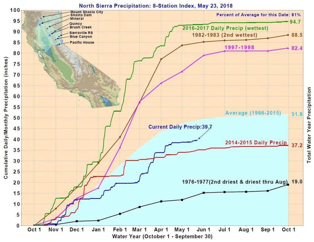
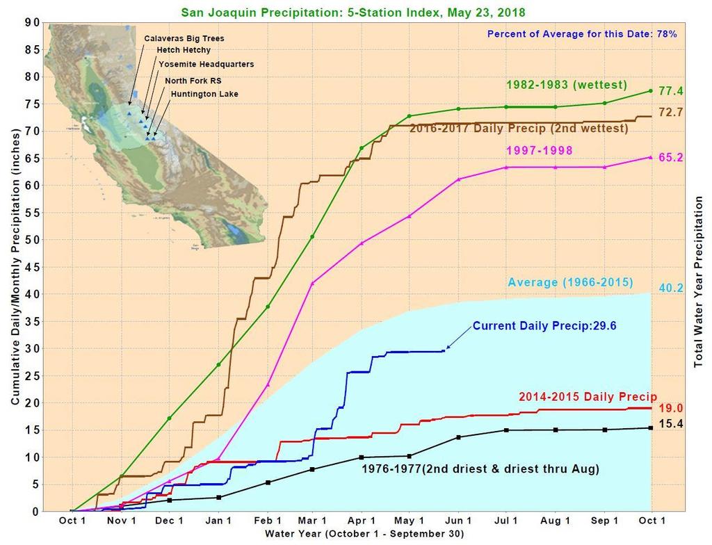
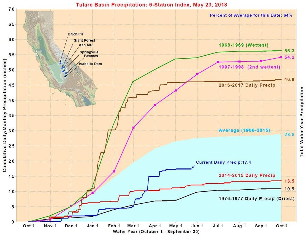
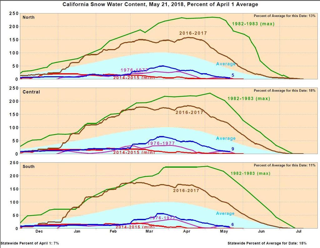
2 2018 Hydrologic Conditions and Water Supply Outlook
3
4
5
6
7
8
9
10

11
12

13
14
15
16
17
18 2018 Water Allocations WEST Federal 45% State 35% CCID 100% EAST SSJID 100% OID 100% Mod ID 100% TID 100% Mer ID 100%
19 Questions & Discussion
20 Sustainable Groundwater Management Act Compliance
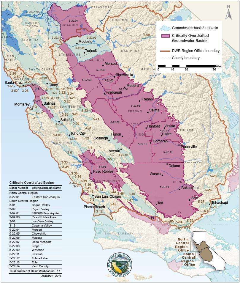
21 Stanislaus County Groundwater Basins *Eastern San Joaquin Modesto Turlock *Delta-Mendota 21 *Denotes Critical Condition of Overdraft

22 22 Stanislaus County Water Agencies
23

24 Eastern San Joaquin Groundwater Basin 5
25 Eastern San Joaquin Subbasin GSAs City of Lathrop Oakdale ID City of Lodi South San Joaquin ID City of Manteca Woodbridge ID City of Stockton Central Delta WD Linden CWD Linden CWD Stockton East WD Central Delta Water Agency South Delta Water Agency Central San Joaquin Water Conservation District North San Joaquin Water Conservation District Eastside San Joaquin GSA

26 Modesto Groundwater Basin 5
27 Stanislaus & Tuolumne Rivers Groundwater Basin Association GSA City of Modesto City of Oakdale City of Riverbank City of Waterford Oakdale ID Modesto ID Stanislaus County Tuolumne County* *Formed separate GSA and linked to STRGBA via separate Cooperation Agreement with Stanislaus County 27

28 Turlock Groundwater Basin 5

29 West Turlock Subbasin GSA 29
30 West Turlock Subbasin GSA City of Ceres City of Hughson City of Modesto City of Turlock Denair CSD Associate Members: Keyes CSD City of Waterford Turlock Irrigation District Merced County Stanislaus County Delhi County Water District Hilmar County Water District

31 East Turlock Subbasin GSA 31
32 East Turlock Subbasin GSA Eastside WD Ballico-Cortez WD Merced Irrigation District Merced County Stanislaus County City of Turlock * * Associate Member
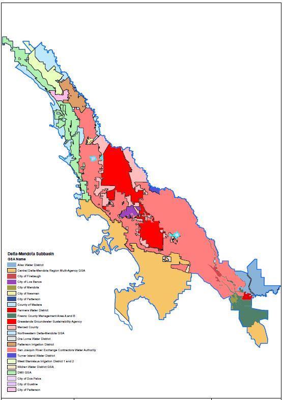
33 Delta-Mendota Subbasin

34 Delta-Mendota Subbasin Northern Group 5
35 Delta-Mendota Groundwater Basin Northern Group GSAs City of Patterson Del Puerto WD West Stanislaus ID Patterson ID Northwestern Delta-Mendota GSA 35
36 Groundwater Sustainability Plans 50 Year Planning Horizon Land Use & Water Demand Nexus Basins in Critical Condition of Overdraft January 31, Year Implementation Period (January 2040) High & Medium Priority Basins January 31, Year Implementation Period (January 2042)
37 37
38 Groundwater Sustainability Plans Grant Funding Basins in Critical Condition of Overdraft ($1.5 M cap) High & Medium Priority Basins ($1 M cap) Require up to 50% Local Cost Share Cost offsets may include Disadvantaged Communities Local relevant SGMA activities (since January 1, 2015) 78 applications (Category 1 & 2) $86.4 M requested out of $86.3 M available ($100,000) Notice of Award in February

39 Bulletin 118 Update - Basin Boundary Adjustment
40 Groundwater Sustainability Plans Next Steps Data Compilation Database Review & Selection Public Outreach Workshops Coordination Agreements Cost-Share Agreements Developing Local Funding Mechanisms Technical Assistance Monitor well installation Facilitation Assistance
41 Questions & Discussion
42 State Water Board Instream Flow Proposal as an Element of the San Joaquin Basin Plan Amendment (SED)
43 Questions & Discussion
44 Programmatic Environmental Impact Report Pertaining to the Stanislaus County Groundwater Ordinance
45 Purpose of PEIR Streamline the Well Permit Application Process Provide a robust technical basis for Groundwater Ordinance implementation Provide data to help facilitate future groundwater sustainability planning (SGMA)
46 Status Public Draft PEIR Comment Period: 45 day period closed May 7, 2018 No comments were received PEIR is being finalized and scheduled to be adopted and certified by the Board of Supervisors in late June
47 PEIR Findings Evaluated 17 resource areas as required by CEQA. For most resource areas, no significant impacts. Where significant impacts can t be ruled out at program level, recommend mitigation measures


48 Initial Study Potential Significant Impact PEIR Potential Significant Impact No Significant impact No Significant impact DONE DONE Well Application Specific Analysis
49 Evaluations Included in PEIR PEIR evaluated 11 resource areas, mitigation recommended for 4: Aesthetics Mineral Resources Population & Housing Public Services Recreation Transportation & Traffic Greenhouse Gas Emissions Air Quality Biological Resources Cultural Resources Geology & Soils Hazards & Hazardous Materials Hydrology & Water Quality Land Use & Planning Noise Utilities & Service Systems Agriculture & Forestry Resources
50 PEIR Specific Findings Groundwater Drawdown and Storage Depletion Surface Water Resources Subsidence Biological Resources Cultural Resources Noise
51 Lessons Learned from the PEIR Significant impacts are NOT expected if permitting requirements and mitigation measures are adopted Well permitting program can be refined to ease burden on areas/wells with little potential for significant impacts Rate of groundwater demand growth in east foothills experienced from 2000 to 2015 is not sustainable in the future Reasonable groundwater demand growth can be met through integrated water management approach (conjunctive use)
52 Future Steps Streamline Permitting Program Develop flowchart that identifies requirements for different well types and locations Checklist to document compliance Establish Groundwater Level Management Zones Evaluation methodology developed for Northern Triangle ( chronic lowering of groundwater levels in Valley Home area) Based on comparing total predicted drawdown over the SGMA implementation horizon, if current groundwater management trends continue, to drawdown significance thresholds (10% impact criterion) Very few are expected to be at issue
53 Available Resources Model files compiled and available for use Reference library available for download Login: StanCoL Password: LibraryJJA9083!
54 Questions & Discussion
Delta-Mendota Groundwater Subbasin
 Delta-Mendota Groundwater Subbasin SGMA Frequently Asked Questions Sustainable Groundwater Management Act What is the Sustainable Groundwater Management Act? The Sustainable Groundwater Management Act,
WEST TURLOCK SUBBASIN GROUNDWATER SUSTAINABILITY AGENCY. December 13, :00 PM Regular Meeting
 WEST TURLOCK SUBBASIN GROUNDWATER SUSTAINABILITY AGENCY December 13, 2018-6:00 PM Regular Meeting Turlock Irrigation District, Board Room 105 333 E. Canal Drive, Turlock, California AGENDA BOARD MEMBERS
Shasta Valley Groundwater Basin Boundary Modification
 Shasta Valley Groundwater Basin Boundary Modification Sustainable Groundwater Management Act (SGMA) September 2014 Governor Brown signs legislation requiring groundwater resources be managed by local agencies
Merced Groundwater Sustainability Plan. Public Meeting August 2, 2018
 Merced Groundwater Sustainability Plan Public Meeting August 2, 2018 Agenda Welcome and Introductions Sustainable Groundwater Management Act Purpose and Requirements Groundwater Sustainability Plan Timeline
Sustainable Groundwater Management Act: Initial Notification of a Proposed Basin Boundary Modification
 Sustainable Groundwater Management Act: Initial Notification of a Proposed Basin Boundary Modification Proposed Boundary Modification The Butte County Department of Water and Resource Conservation has
Tule Subbasin: Sustainable Groundwater Management Act (SGMA) August 24, 2016 David De Groot, Professional Engineer 4Creeks, Inc.
 August 24, 2016 David De Groot, Professional Engineer 4Creeks, Inc.") Tule Subbasin: Sustainable Groundwater Management Act (SGMA) August 24, 2016 David De Groot, Professional Engineer 4Creeks, Inc. Overview 1 SUSTAINABLE GROUNDWATER MANAGEMENT ACT 2 TECHNICAL OVERVIEW OF
Tule Subbasin: Sustainable Groundwater Management Act (SGMA) August 24, 2016 David De Groot, Professional Engineer 4Creeks, Inc. Overview 1 SUSTAINABLE GROUNDWATER MANAGEMENT ACT 2 TECHNICAL OVERVIEW OF
Butte County Board of Supervisors Agenda Transmittal
 Butte County Board of Supervisors Agenda Transmittal Clerk of the Board Use Only Agenda Item: 3.38 Subject: Resolution to Establish the Butte County Groundwater Sustainability Agency in the West Butte
Napa Valley Groundwater Sustainability: A Basin Analysis Report for the Napa Valley Subbasin
 Napa Valley Groundwater Sustainability: A Basin Analysis Report for the Napa Valley Subbasin A report prepared pursuant to California Water Code Section 10733.6(b)(3) EXECUTIVE SUMMARY (354.4(A)) 1 1.0
Santa Clara Valley Water District Page 1 of 4
 Santa Clara Valley Water District File No.: 16-0304 Agenda Date: 5/24/2016 Item No.: 2.7. BOARD AGENDA MEMORANDUM SUBJECT: Public Hearing and Resolution on the Decision to Become the Groundwater Sustainability
DRAFT. REVISED Draft. Paso Robles Subbasin Groundwater Sustainability Plan Chapter 6
 REVISED Draft Paso Robles Subbasin Groundwater Sustainability Plan Chapter 6 Prepared for the Paso Robles Subbasin Cooperative Committee and the Groundwater Sustainability Agencies February 14, 2019 Paso
COUNTY OF GLENN BOARD REPORT. Submitted by Department of Agriculture
 COUNTY OF GLENN BOARD REPORT Submitted by Department of Agriculture EXECUTIVE SUMMARY: There are three subbasins in Glenn County required to be managed under the Sustainable Groundwater Management Act
APPENDIX G. Groundwater Basin Descriptions and Discussion on Groundwater Operational Yield
 APPENDIX G Groundwater Basin Descriptions and Discussion on Groundwater Operational Yield San Joaquin Valley Groundwater Basin Modesto Subbasin Groundwater Subbasin Number: 5-22.02 County: Stanislaus
East Bay Plain Basin. EBMUD & City of Hayward. Groundwater Reliability Partnership Meeting March 22, 2017
 East Bay Plain Basin EBMUD & City of Hayward Groundwater Reliability Partnership Meeting March 22, 2017 Agenda Overview of the East Bay Plain Basin EBMUD s Bayside Groundwater Project EBMUD s Activities
COUNTY OF SAN LUIS OBISPO BOARD OF SUPERVISORS AGENDA ITEM TRANSMITTAL
 COUNTY OF SAN LUIS OBISPO BOARD OF SUPERVISORS AGENDA ITEM TRANSMITTAL (1) DEPARTMENT Public Works (2) MEETING DATE 4/9/2019 (3) CONTACT/PHONE Mladen Bandov Senior Water Resources Engineer (805) 781-5116
WHITE WOLF GSA ACCOMPLISHMENTS AND SHORT-TERM SGMA COMPLIANCE GOALS
 WHITE WOLF GSA ACCOMPLISHMENTS AND SHORT-TERM SGMA COMPLIANCE GOALS 22 AUGUST 2017 OUTLINE SGMA Compliance Timeline Accomplishments to Date SGMA Road Map for the White Wolf Subbasin 2042 2022 2017 2016
Technical Memorandum. 1 Study Area. Interbasin Groundwater Flow Evaluation
 Technical Memorandum Interbasin Groundwater Flow Evaluation Subject: Prepared For: Butte County Department of Water and Resource Conservation Prepared by: Sara Miller and Craig Altare, P.G. Reviewed by:
City of Chino Hills General Plan Update 13GPA02 Scoping Meeting. June 4, 2013
 13GPA02 Scoping Meeting June 4, 2013 Every California city must adopt a comprehensive, long-term general plan. The General Plan is the City s constitution or blueprint for its long-range physical development.
S A N M AT E O P L A I N G R O U N D W AT E R B A S I N A S S E S S M E N T S TA K E H O L D E R W O R K S H O P # 4 D E C E M B E R 6,
 S A N M AT E O P L A I N G R O U N D W AT E R B A S I N A S S E S S M E N T S TA K E H O L D E R W O R K S H O P # 4 D E C E M B E R 6, 2 0 1 6 PRESENTATION OVERVIEW Introductions Project Overview Review
Lower San Joaquin River Committee
 Lower San Joaquin River Committee Briefing of New Melones Project and Vernalis Modeling Dan Steiner January 3, 215 1 Task Demonstrate effects of changed flow and salinity in the San Joaquin River upon
TECHNICAL MEMORANDUM: MADERA SUBBASIN. Sustainable Groundwater Management Act (SGMA) DRAFT PRELIMINARY BASIN BOUNDARY WATER BUDGET.
 DRAFT PRELIMINARY BASIN BOUNDARY WATER BUDGET.") TECHNICAL MEMORANDUM: MADERA SUBBASIN Sustainable Groundwater Management Act (SGMA) DRAFT PRELIMINARY BASIN BOUNDARY WATER BUDGET Prepared by February 2018 DRAFT PRELIMINARY Technical Memorandum: Madera
TECHNICAL MEMORANDUM: MADERA SUBBASIN Sustainable Groundwater Management Act (SGMA) DRAFT PRELIMINARY BASIN BOUNDARY WATER BUDGET Prepared by February 2018 DRAFT PRELIMINARY Technical Memorandum: Madera
GOAL 7 AREAS SUBJECT TO NATURAL DISASTERS AND HAZARDS. To protect life and property from natural disasters and hazards.
 GOAL 7 AREAS SUBJECT TO NATURAL DISASTERS AND HAZARDS A. GOALS: To protect life and property from natural disasters and hazards. B. POLICIES: 1. Floodplains shall be maintained as natural drainage-ways.
5. Environmental Analysis
 5.9 MINERAL RESOURCES 5.9.1 Methodology The California Geological Survey Mineral Resources Project provides information about California s nonfuel mineral resources. The primary focus of the Mineral Resources
Hydrogeologic Conceptual Models for Regional Flow Systems
 Hydrogeologic Conceptual Models for Regional Flow Systems R.T. Hanson, U.S. Geological Survey One Water Hydrologic Flow Model USGS MODFLOW-OWHM Session 4 Groundwater Subbasin Baseline Historic and Current
Napa Valley Groundwater Sustainability: A Basin Analysis Report for the Napa Valley Subbasin
 Napa Valley Groundwater Sustainability: A Basin Analysis Report for the Napa Valley Subbasin December 13, 2016 Napa County Board of Supervisors By Vicki Kretsinger Grabert and Reid Bryson Basin Analysis
Proposed Scope of Work Village of Farmingdale Downtown Farmingdale BOA Step 2 BOA Nomination Study / Draft Generic Environmental Impact Statement
 Proposed Scope of Work Village of Farmingdale Downtown Farmingdale BOA Step 2 BOA Nomination Study / Draft Generic Environmental Impact Statement The scope of work that follows incorporates and covers
COUNTY OF SACRAMENTO CALIFO IA
 APP,,tovED MAIO OF SVIDERVISORS 1 ivo, W0,7-02 0 A 11 2017 Lit/ficfr ' By Clerk of the Board COUNTY OF SACRAMENTO CALIFO IA 71 For the Agenda of: April 11,2017 2:00 PM To: From: Subject: Supervisorial
2007 Area Source Emissions Inventory Methodology 670 RANGE IMPROVEMENT
 San Joaquin Valley AIR POLLUTION CONTROL DISTRICT 2007 Area Source Emissions Inventory Methodology 670 RANGE IMPROVEMENT I. Purpose This document describes the Area Source Methodology used to estimate
2001 ANNUAL REPORT on INTERBASIN TRANSFERS for RTP South and the Towns of Cary, Apex, and Morrisville
 2001 ANNUAL REPORT on INTERBASIN TRANSFERS for RTP South and the Towns of Cary, Apex, and Morrisville Prepared for: Town of Cary Town of Apex Town of Morrisville RTP South/Wake County Submitted to: North
GIS ADMINISTRATOR / WEB DEVELOPER EVANSVILLE-VANDERBURGH COUNTY AREA PLAN COMMISSION
 GIS ADMINISTRATOR / WEB DEVELOPER EVANSVILLE-VANDERBURGH COUNTY AREA PLAN COMMISSION SALARY RANGE INITIATION $43,277 SIX MONTHS $45,367 POSITION GRADE PAT VI The Evansville-Vanderburgh County Area Plan
Tehama County Groundwater Sustainability Agency Groundwater Commission
 Tehama County Groundwater Sustainability Agency Groundwater Commission Wednesday, April 25, 2018 8:30 AM Tehama County Board of Supervisors Chambers 727 Oak Street, Red Bluff, CA 96080 http://www.tehamacountypublicworks.ca.gov/flood/
PRELIMINARY WORKING DRAFT Work in Progress
 IV. ENVIRONMENTAL IMPACT ANALYSIS H. MINERAL RESOURCES 1.0 INTRODUCTION This section addresses the potential impacts of the Proposed Project on mineral resources (i.e., sand, gravel and petroleum). The
5.11 MINERAL RESOURCES
 5.11 This section of the Draft PEIR evaluates the potential impacts to mineral resources in the Plan Area from implementation of the Clovis General Plan and Development Code Update (proposed project).
Template for Sediment and Erosion Control Plan General Instructions. Section Instructions
 Template for Sediment and Erosion Control Plan General Instructions Introduction: Soil erosion and sediment deposition from farmlands can contribute to degraded surface water quality. Sediment delivery
Randall W. Parkinson, Ph.D., P.G. Institute of Water and Environment Florida International University
 An Update on Adaptation Action Activities Undertaken Since Completion of the City of Satellite Beach (FL) Vulnerability Assessment to Rising Seas (2010) Randall W. Parkinson, Ph.D., P.G. Institute of Water
Draft. Butte County Long-Term Regional Growth Forecasts
 Draft Butte County Long-Term Regional Growth Forecasts 2014 2040 Prepared by: November 25 th, 2014 2580 Sierra Sunrise Terrace, Suite 100 Chico, CA 95928 Phone: 530-879-2468 FAX: 530-879-244 www.bcag.org
San Joaquin Valley Air Pollution Control District Annual Report. Indirect Source Review Program
 San Joaquin Valley Air Pollution Control District 2017 Annual Report Indirect Source Review Program Reporting Period: July 1, 2016 to June 30, 2017 SAN JOAQUIN VALLEY AIR POLLUTION CONTROL DISTRICT GOVERNING
WORKFORCE SERVICES DIRECTIVE. This policy officially identifies California s regional planning units.
 WORKFORCE SERVICES DIRECTIVE Attachment C Number: WSD15-17 Date: February 24, 2016 69:175:rc TO: WORKFORCE DEVELOPMENT COMMUNITY SUBJECT: CALIFORNIA WIOA REGIONAL PLANNING UNITS EXECUTIVE SUMMARY Purpose
Guidelines for Site-Specific Seismic Hazard Reports for Essential and Hazardous Facilities and Major and Special-Occupancy Structures in Oregon
 Guidelines for Site-Specific Seismic Hazard Reports for Essential and Hazardous Facilities and Major and Special-Occupancy Structures in Oregon By the Oregon Board of Geologist Examiners and the Oregon
Merced Subbasin Groundwater Sustainability Agency Governing Board
 Merced Subbasin Groundwater Sustainability Agency Governing Board County of Merced Board Chambers, Third Floor 2222 M Street, Merced, California Regular Meeting July 13, 2017 2:00PM AGENDA Bob Kelley,
Final Results and Outreach Lessons Learned
 FEMA REGION III COASTAL HAZARD STUDY Final Results and Outreach Lessons Learned June 4, 2014 Mari Radford Christine Worley Robin Danforth David Bollinger FEMA Region III RAMPP FEMA Region III FEMA Region
San Francisco Public Utilities Commission Hydrological Conditions Report For March 2016
 San Francisco Public Utilities Commission Hydrological Conditions Report For March 2016 J. Chester, C. Graham, A. Mazurkiewicz, & M. Tsang, April 7, 2016 Snow Surveyor Chris Graham crossing Huckleberry
APPLICATIONS OF EARTHQUAKE HAZARD MAPS TO LAND-USE AND EMERGENCY PLANNING EXAMPLES FROM THE PORTLAND AREA
 APPLICATIONS OF EARTHQUAKE HAZARD MAPS TO LAND-USE AND EMERGENCY PLANNING EXAMPLES FROM THE PORTLAND AREA O. Gerald Uba Metro, Portland, Oregon OVERVIEW The extent to which we understand "below ground"
Date: June 19, 2013 Meeting Date: July 5, Consideration of the City of Vancouver s Regional Context Statement
 Section E 1.5 To: From: Regional Planning and Agriculture Committee Lee-Ann Garnett, Senior Regional Planner Planning, Policy and Environment Department Date: June 19, 2013 Meeting Date: July 5, 2013 Subject:
Republic of Mozambique
 Republic of Mozambique Second Expert's Symposium on Multi-Hazard Early Warning Systems with focus on the Role of National Meteorological and Hydrological Services 5-7 May 2009, Toulouse France 1. Background
Template for Sediment and Erosion Control Plan General Instructions
 Template for Sediment and Erosion Control Plan General Instructions Introduction: Soil erosion and sediment deposition from farmlands can contribute to degraded surface water quality. Sediment delivery
Folsom Dam Water Control Manual Update Joint Federal Project, Folsom Dam
 Folsom Dam Water Control Manual Update Joint Federal Project, Folsom Dam Public Workshop May 28, 2015 Library Galleria 828 I Street, Sacramento, CA US Army Corps of Engineers BUILDING STRONG WELCOME &
City Council Agenda Report
 Crl Ya, CHICO City Council Agenda Report Meeting Date: 217117 TO: City Council FROM: Erik Gustafson, Public Works Director-O&M, (894-4202) RE: CONSIDERATION OF A MEMORANDUM OF UNDERSTANDING FOR THE VINA
4.11 CULTURAL RESOURCES
 4.11 CULTURAL RESOURCES 4.11 CULTURAL RESOURCES This section summarizes the cultural resources of. Information reviewed for the summary includes the General Plan, published reports on archaeological research
Estimation of Short Term Shelter Needs FEMA Earthquake HAZUS Model
 July 2017 ESRI International Users Conference Estimation of Short Term Shelter Needs FEMA Earthquake HAZUS Model Techniques & Results Douglas Schenk / Sampa Patra GIS Group / Information Services Division
Cuyama Basin North Fork Vineyard
 Cuyama Basin North Fork Vineyard Company Background plus Data Insights to Support GSP Development for the Cuyama Basin Presented by Grapevine Capital Partners and Cleath-Harris Geologists April 26th, 2018
APPLICATION TO AMEND THE FUTURE LAND USE MAP (FLUM) SMALL SCALE
 SMALL SCALE") DEPARTMENT OF DEVELOPMENT & PLANNING 825 Ohio Avenue - Lynn Haven, FL 32444 (850) 265-2961 - (850) 265-3478 APPLICATION TO AMEND THE FUTURE LAND USE MAP (FLUM) SMALL SCALE Deadline to submit is 30 days
DEPARTMENT OF DEVELOPMENT & PLANNING 825 Ohio Avenue - Lynn Haven, FL 32444 (850) 265-2961 - (850) 265-3478 APPLICATION TO AMEND THE FUTURE LAND USE MAP (FLUM) SMALL SCALE Deadline to submit is 30 days
TECHNICAL PUBLICATION SJ WATER SUPPLY ASSESSMENT 2003 ST. JOHNS RIVER WATER MANAGEMENT DISTRICT
 TECHNICAL PUBLICATION SJ2006-1 WATER SUPPLY ASSESSMENT 2003 ST. JOHNS RIVER WATER MANAGEMENT DISTRICT Technical Publication SJ2006-1 Water Supply Assessment 2003 Palatka, Florida 2006 Northwest Florida
TABLE OF CONTENTS ARTICLE I. POLK COUNTY COMPREHENSIVE PLAN VOLUME 1. Page CHAPTER 1. GENERAL... A-1
 TABLE OF CONTENTS ARTICLE I. POLK COUNTY COMPREHENSIVE PLAN VOLUME 1 Page CHAPTER 1. GENERAL... A-1 DIVISION 1.100 GENERAL PROVISIONS... A-1 DIVISION 1.200 BASIC PRINCIPLES... A-6 DIVISION 1.300 THE PLANNING
The National Integrated Drought Information System (NIDIS) Moving the Nation from Reactive to Proactive Drought Risk Management
 Moving the Nation from Reactive to Proactive Drought Risk Management") The National Integrated Drought Information System (NIDIS) Moving the Nation from Reactive to Proactive Drought Risk Management CSG-West Annual Meeting Agriculture & Water Committee Snowbird, UT September
The National Integrated Drought Information System (NIDIS) Moving the Nation from Reactive to Proactive Drought Risk Management CSG-West Annual Meeting Agriculture & Water Committee Snowbird, UT September
4.12 Mineral Resources
 4.12.1 Setting Section 2.2, Project Location, provides general information about the Project s regional and local setting. This Section 4.12.1 provides setting information specific to mineral resources.
THE IMPACT OF LANDSLIDE AREAS ON MUNICIPAL SPATIAL PLANNING
 THE IMPACT OF LANDSLIDE AREAS ON MUNICIPAL SPATIAL PLANNING Jarosław Bydłosz, PhD Faculty of Mining Surveying and Environmental Engineering AGH University of Science and Technology e-mail: bydlosz@agh.edu.pl
Climate Change Impact on Air Temperature, Daily Temperature Range, Growing Degree Days, and Spring and Fall Frost Dates In Nebraska
 EXTENSION Know how. Know now. Climate Change Impact on Air Temperature, Daily Temperature Range, Growing Degree Days, and Spring and Fall Frost Dates In Nebraska EC715 Kari E. Skaggs, Research Associate
Dark Sky Initiative Draft Terms of Reference
 Dark Sky Initiative Draft Terms of Reference July 2008 Table of Contents 1.0 Introduction 2 2.0 Initiative intent 2-3 3.0 Initiative goals 3 4.0 Legislation 3 5.0 Municipal Development Plan 3 6.0 Land
Spatial Data Availability Energizes Florida s Citizens
 NASCIO 2016 Recognition Awards Nomination Spatial Data Availability Energizes Florida s Citizens State of Florida Agency for State Technology & Department of Environmental Protection Category: ICT Innovations
Mineral Resources
 Sacramento Local Agency Formation Commission Mineral Resources 3.11 - Mineral Resources 3.11.1 - Introduction This section describes and evaluates potential environmental impacts to mineral resources resulting
City of Manitou Springs
 March 2018 City of Manitou Springs Implementing Land Use tools to reduce and mitigate natural hazard risk Context & History Past Present Historic homes Older infrastructure Hillside development Creekside
Flash Flood Guidance System On-going Enhancements
 Flash Flood Guidance System On-going Enhancements Hydrologic Research Center, USA Technical Developer SAOFFG Steering Committee Meeting 1 10-12 July 2017 Jakarta, INDONESIA Theresa M. Modrick Hansen, PhD
APPENDIX I: Traffic Forecasting Model and Assumptions
 APPENDIX I: Traffic Forecasting Model and Assumptions Appendix I reports on the assumptions and traffic model specifications that were developed to support the Reaffirmation of the 2040 Long Range Plan.
4.9 GEOLOGY AND SOILS
 4.9 GEOLOGY AND SOILS 4.9.1 EXISTING CONDITIONS TOPOGRAPHY AND RELIEF Zone 40 is located in the central portion of Sacramento County. The topography of the county is represented by three physiographic
Land Accounts - The Canadian Experience
 Land Accounts - The Canadian Experience Development of a Geospatial database to measure the effect of human activity on the environment Who is doing Land Accounts Statistics Canada (national) Component
3.5 Geology, Soils, and Paleontology
 3.5 Geology, Soils, and Paleontology Overview of Impacts The analytical approach taken by this Subsequent EIR is described in Section 3.0 (Introduction to Environmental Analysis). The following section
KENYA NATIONAL BUREAU OF STATISTICS Workshop on
 KENYA NATIONAL BUREAU OF STATISTICS Workshop on Capacity Building in Environment Statistics: the Framework for the Development of Environment Statistics (FDES 2013) Coordination with Sector Ministries
King City URA 6D Concept Plan
 King City URA 6D Concept Plan King City s Evolution Among the fastest growing cities 2000 Census 1,949 2010 Census 3,111 60% increase 2016 Census estimate 3,817 23% increase Average annual rate 4.3% Surpassing
STATE GEOGRAPHIC INFORMATION DATABASE
 STATE GEOGRAPHIC INFORMATION DATABASE Data Information and Knowledge Management STATE GEOGRAPHIC INFORMATION DATABASE EXECUTIVE SUMMARY Utah has developed one of the most comprehensive statewide GIS resources
Country Report Nepal Geospatial Data Sharing Initiatives of Survey Department Supporting Disaster Management
 Third JPTM Step 2 for Sentinel Asia 6-8 July, 2010 Manila, The Philippines Country Report Nepal Geospatial Data Sharing Initiatives of Survey Department Supporting Disaster Management Durgendra M Kayastha
Precipitation. Standardized Precipitation Index. NIDIS Intermountain West Drought Early Warning System September 5, 2017
 9/6/2017 NIDIS Drought and Water Assessment NIDIS Intermountain West Drought Early Warning System September 5, 2017 Precipitation The images above use daily precipitation statistics from NWS COOP, CoCoRaHS,
APPENDIX V VALLEYWIDE REPORT
 APPENDIX V VALLEYWIDE REPORT Page Intentionally Left Blank 1.2 San Joaquin Valley Profile Geography The San Joaquin Valley is the southern portion of the Great Central Valley of California (Exhibit 1-1).
ADDRESSING TITLE VI AND ENVIRONMENTAL JUSTICE IN LONG-RANGE TRANSPORTATION PLANS
 ADDRESSING TITLE VI AND ENVIRONMENTAL JUSTICE IN LONG-RANGE TRANSPORTATION PLANS Activities from the National Capital Region Transportation Planning Board Sergio Ritacco Transportation Planner 2017 Association
California 120 Day Precipitation Outlook Issued Tom Dunklee Global Climate Center
 California 120 Day Precipitation Outlook Issued 11-01-2008 Tom Dunklee Global Climate Center This is my second updated outlook for precipitation patterns and amounts for the next 4 s of the current rainy
ACTON COMMUNITY WIDE ARCHAEOLOGICAL RECONNAISSANCE SURVEY. Town of Acton and PAL, Inc.
 ACTON COMMUNITY WIDE ARCHAEOLOGICAL RECONNAISSANCE SURVEY Town of Acton and PAL, Inc. Objectives and Scope of Work Four phase study; (1. research, 2. draft report outline, resource protection bylaw, 3.
Economic and Social Council
 United Nations Economic and Social Council Distr.: General 18 July 2016 Original: English Committee of Experts on Global Geospatial Information Management Sixth session New York, 3-5 August 2016 Item 2
City of Lockport Historic Resources Survey - Section METHODOLOGY
 2.0 METHODOLOGY Clinton Brown Company PN 07-008 2-1 April 2011 2.0 METHODOLOGY This methodology statement is prepared as part of the project tasks. It outlines the research sources identified, field strategies,
Facts and Findings. Exhibit A-1
 Exhibit A-1 Facts and Findings The county periodically prepares coordinated countywide forecasts for all the cities in the county and the unincorporated area. These forecasts can be used by cities as a
Illinois Drought Update, December 1, 2005 DROUGHT RESPONSE TASK FORCE Illinois State Water Survey, Department of Natural Resources
 Illinois Drought Update, December 1, 2005 DROUGHT RESPONSE TASK FORCE Illinois State Water Survey, Department of Natural Resources For more drought information please go to http://www.sws.uiuc.edu/. SUMMARY.
SAN JOAQUIN VALLEY AIRSHED
 SAN JOAQUIN VALLEY AIRSHED INTRODUCTION This chapter describes the naturally occurring determinants of air quality in the San Joaquin Valley Air Basin (SJVAB) relative to PM10. There are numerous factors
COUNTY OF SONOMA PERMIT AND RESOURCE MANAGEMENT DEPARTMENT 2550 Ventura Avenue, Santa Rosa, CA (707) FAX (707)
 FAX (707)") COUNTY OF SONOMA PERMIT AND RESOURCE MANAGEMENT DEPARTMENT 2550 Ventura Avenue, Santa Rosa, CA 95403 (707) 565-1900 FAX (707) 565-1103 DATE : TO: FROM: SUBJECT: July 21, 2009 at 2:30 p.m. Board of Supervisors
COUNTY OF SONOMA PERMIT AND RESOURCE MANAGEMENT DEPARTMENT 2550 Ventura Avenue, Santa Rosa, CA 95403 (707) 565-1900 FAX (707) 565-1103 DATE : TO: FROM: SUBJECT: July 21, 2009 at 2:30 p.m. Board of Supervisors
Application #: TEXT
 TOWN OF FORT MYERS BEACH 2008 PROPOSED COMPREHENSIVE PLAN AMENDMENTS Application #: 2008-13-TEXT Description: Modify the Coastal Management and Future Land Use Elements to reflect the state s new definition
STAFF REPORT ACTION REQUIRED
 STAFF REPORT ACTION REQUIRED Appeal by Fast Signs of the Decision of the Chief Building Official for One Variance Respecting a Proposed First Party Wall Sign 10-21 Four Seasons Place Date: January 18,
DEPARTMENT OF GEOLOGY AND MINERAL INDUSTRIES WAYS & MEANS SUBCOMMITTEE ON NATURAL RESOURCES MARCH 2, 2017
 DEPARTMENT OF GEOLOGY AND MINERAL INDUSTRIES WAYS & MEANS SUBCOMMITTEE ON NATURAL RESOURCES MARCH 2, 2017 1 ABOUT DOGAMI AGENCY MISSION, VISION & GOALS 2 Lidar image of a stream network along the Umpqua
Seismic Geotechnical Hazard Zonation Of Geological Factors
 1 st Workshop of M.E.E.T.I.N.G Project Seismic Geotechnical Hazard Zonation Of Geological Factors Maja Oštri, dipl.ing.geol Dubrovnik, March 3rd-4th 2008 SUBJECT OF THE INVESTIGATION? Geological Factors
Atlas of the Upper Gila River Watershed
 Atlas of the Upper Gila River Watershed Katie Banister, David Chan, Jessica M. Driscoll, Christopher Fullerton, Aaron Lien and Kelly Mott Lacroix January 2014 The University of Arizona Water Resources
5. Environmental Analysis
 5.11 This section of the Draft Environmental Impact Report (DEIR) evaluated potential impacts to mineral resources from implementation of the General Plan. 5.11.1 Environmental Setting Minerals are defined
SOLANO SUBBASIN GROUNDWATER SUSTAINABILITYAGENCY
 SOLANO SUBBASIN GROUNDWATER SUSTAINABILITYAGENCY BOARD OF DIRECTORS: Chair: Supervisor Skip Thomson Solano County District 5 Vice Chair: BOARD OF DIRECTORS MEETING DATE: Thursday, April 12, 2018 Vice-Mayor
Dunn County Snow Removal Policy
 Dunn County Snow Removal Policy OVERVIEW With the advent of another winter season in the northern plains comes the possibility of snow, freezing rain and slippery roadways, and area resident s concern
ICZM and MSP in the Black Sea Region
 ICZM and MSP in the Black Sea Region Drd. Claudia Coman, Environmental engineer AG ICZM Focal Point, Romania Black Sea Commission Black Sea Commission on the Protection of the Black Sea against Pollution
Summary of Available Datasets that are Relevant to Flood Risk Characterization
 Inter-Agency Characterization Workshop February 25-27, 2014 USACE Institute for Water Resources, Alexandria, VA, IWR Classroom Summary of Available Datasets that are Relevant to Characterization National
Exhibit IV-1: Initiation of Zoning Map Amendments Case Report HEARING DATE: MAY 3, 2012
 Exhibit IV-1: Initiation of Zoning Map Amendments Case Report HEARING DATE: MAY, 01 Case No.: 00.0MTZU Transit Center District Plan Amendments to Zoning Map Staff Contact: Joshua Switzky - (1) -1 joshua.switzky@sfgov.org
Harvey Thorleifson, Director, Minnesota Geological Survey. Status of geological mapping needed for groundwater protection in Minnesota
 Harvey Thorleifson, Director, Minnesota Geological Survey Status of geological mapping needed for groundwater protection in Minnesota Minnesota is located between the Dakotas and Wisconsin, north of Iowa,
McHenry County Property Search Sources of Information
 Disclaimer: The information in this system may contain inaccuracies or typographical errors. The information in this system is a digital representation of information derived from original documents; as
Regional Growth Strategy Regional Staff Committee
 Regional Growth Strategy Regional Staff Committee June 21, 2018 1 Overview Summary of June Growth Management Policy Board Regional Growth Strategy Objectives Regional Geographies Regional Growth Strategy
Report to the Seventy-first Legislative Assembly on the Implementation of 1999 Senate Bill 12 Relating to Public Safety and Rapidly Moving Landslides
 Report to the Seventy-first Legislative Assembly on the Implementation of 1999 Senate Bill 12 Relating to Public Safety and Rapidly Moving Landslides December 28, 2000 Department of Geology and Mineral
WATER RESOURCES AND URBANIZATION Vulnerability and Adaptation in the Context of Climate Variability
 WATER RESOURCES AND URBANIZATION Vulnerability and Adaptation in the Context of Climate Variability Krishna Balakrishnan LA 221: Class Project Problem Statement My PhD research focuses on the vulnerability
Summary Description Municipality of Anchorage. Anchorage Coastal Resource Atlas Project
 Summary Description Municipality of Anchorage Anchorage Coastal Resource Atlas Project By: Thede Tobish, MOA Planner; and Charlie Barnwell, MOA GIS Manager Introduction Local governments often struggle
Seth J. Wittke Wyoming State Geological Survey
 Seth J. Wittke Wyoming State Geological Survey Project initiation Data manipulation Scenarios Creating the IMS Lessons learned County-wide block level probabilistic models created in 2004 for state mitigation
FINAL AESTHETICS RESOURCES STUDY PLAN. Takatz Lake Hydroelectric Project, FERC No Prepared by: City and Borough of Sitka Electric Department
 FINAL AESTHETICS RESOURCES STUDY PLAN Takatz Lake Hydroelectric Project, FERC No. 13234 Prepared by: City and Borough of Sitka Electric Department 105 Jarvis St., Sitka AK, 99835 INTRODUCTION and BACKGROUND