Sustainable Groundwater Management Act: Initial Notification of a Proposed Basin Boundary Modification
|
|
|
- Myrtle Dalton
- 5 years ago
- Views:
Transcription

1 Sustainable Groundwater Management Act: Initial Notification of a Proposed Basin Boundary Modification
2 Proposed Boundary Modification The Butte County Department of Water and Resource Conservation has submitted to the Department of Water Resources (DWR) an initial notification to explore a basin boundary modification. The proposed basin boundary modification is a jurisdictional modification involving a consolidation of the Vina ( ), West Butte ( ), East Butte ( ) and North Yuba ( ) subbasins that lie within Butte County and a boundary adjustment along the Butte County line except for the portion of the Yuba County Water Agency that extends into Butte County. The modification would create a new subbasin called the Butte subbasin or Butte Basin (Figure 1). The Butte subbasin includes the water bearing units of the Tuscan, Laguna, Riverbank and Modesto formations. The Groundwater Sustainability Agencies in the Butte Basin include Butte County, the City of Chico, the City of Biggs, the City of Gridley, the City of Oroville, Western Canal Water District, Richvale Irrigation District, Biggs West Gridley Water District, Butte Water District, Thermalito Water and Sewer District and Butte College. Background The Sustainable Groundwater Management Act (SGMA) went into effect on January 1, There are 127 Bulletin 118 subbasins designated by the California Statewide Groundwater Elevation Monitoring (CASGEM) program as high or medium priority. In these subbasins, Groundwater Sustainability Agencies (GSA) must be formed and take responsibility to develop and implement a Groundwater Sustainability Plan (GSP). A GSA can be formed by a single local public agency, or combination of agencies. If a GSA is not formed by June 30, 2017, the State Water Resources Control Board (SWRCB) will intervene, impose fees and assume management of the basin. There are four subbasins (Vina, West Butte, East Butte and North Yuba) subject to SGMA that are within the boundaries of Butte County. Butte County and most of the other local public agencies in these subbasins have elected to be a GSA. While many decisions lie ahead on governance and GSP development, one of the near-term decisions facing local agencies is whether to request a modification to basin boundaries. In anticipation of the basin boundary modification review, on March 25, 2015, the Butte County Board of Supervisors directed the Department of Water and Resource Conservation (Department) to evaluate whether basin boundaries should be adjusted in a manner that will improve the likelihood of achieving sustainable groundwater management (Resolution ). The Department is proposing a modification to the four subbasins by combining them into a single subbasin that would be bounded within Butte County. The Department is providing initial notice of the proposed basin boundary modification pursuant to Section of DWR s Groundwater Basin Boundaries Regulations (Code of California Regulations Title 23, Division 2, Chapter 1.5, Subchapter 1). P a g e 1
3 Near-term decision: Modify Basin Boundaries The Bulletin 118 subbasins were a reasonable starting point for managing groundwater. However, it is well-recognized that many of the basin boundaries do not reflect hydrogeology or would not foster sustainable groundwater management. As a remedy, SGMA provided local agencies with the ability to request that DWR modify basin boundaries according to regulations [Water Code ]. DWR adopted regulations in November 2015 that prescribe the types of basin boundary modifications, the information required, local agency consultation and the criteria for approval. Local agencies have a variety of options for basin boundary modifications. However, modification requests must be supported by information, justification and meet the criteria for approval. The deadline to submit requests to DWR is March 31, DWR will evaluate requests to determine whether it will promote sustainable groundwater management. DWR may deny a request if it would limit: sustainable groundwater management in the proposed or other basins groundwater storage or recharge in the proposed or adjoining subbasins the coordination of management activities and the sharing of data and information across subbasin boundaries. The formal request to modify a basin boundary must include specific information, data and a demonstration of consultation with local agencies and affected water systems [Groundwater Basin Boundaries Regulations 344]. Additionally, SGMA requires that the GSA consider the interests of all beneficial uses and users of groundwater [Water Code ]. To facilitate coordination and consultation with local agencies and affected systems, the Groundwater Basin Boundaries Regulations ( 343.9) has a process for local agencies to explore possible basin boundary modifications. This paper describes the proposed basin boundary modification and the opportunity to provide input. Providing Input The purpose of the initial notification of a basin boundary modification is to solicit discussion and the opportunity to provide input. The decision of Butte County to formally request a basin boundary modification will be made by the Butte County Board of Supervisors. As part of the Board of Supervisors consideration will be a potential recommendation from the Butte County Water Commission. To meet the March 31, 2016 deadline, a decision by the Board of Supervisors will have to be made by their March 22, 2016 meeting. P a g e 2
4 The input provided by other local agencies, affected systems and interested parties will be a valuable part of the Water Commission and Board of Supervisors consideration. To facilitate local agency consultation and public participation, the Department has: Established a webpage specifically for the basin boundary modification process that can be accessed from the Department s main webpage at: Notified Local Agencies and Affected Systems. The notification is in addition to discussions and meetings held with local agencies and affected systems. Informed interested parties through the January 2016 edition of the WaterSolutions newsletter. Conducted an assessment of local agencies and various stakeholder groups. The assessment report will provide valuable input a range of SGMA implementation topics including basin boundary modification options. Presented the proposed basin boundary modification to the Water Commission at their January 6, 2016 meeting. It is anticipated that the Water Commission will discuss the proposed basin boundary modification options at their February and March meetings. The Department requests that comments including resolutions of support, opposition or modification be submitted by February 15, 2016 by either (BCWater@buttecounty.net) or by mail to Butte County Department of Water and Resource Conservation, 308 Nelson Avenue, Oroville, CA 95965, Attn: Basin Boundaries. Regulatory Effect of Basin Modification Basin boundary modifications can be beneficial to SGMA implementation. However, basin boundary modifications will not change the foundational requirements of SGMA or the necessity to coordinate with adjoining subbasins. Whether basins or subbasins are modified, GSAs will have complex decisions regarding how to best develop, coordinate and implement one or more GSPs for their subbasin or portion of a subbasin. What s required in a subbasin? Establish one or more GSAs. Local agencies have options on how they may structure their GSA within their subbasin. A local public agency or combination of agencies may establish a GSA. For example, if a subbasin includes one or more public agencies (water districts, city and county), they could form a GSA using a joint powers agreement or memorandum of agreement and submit one GSP for all or a portion of a subbasin. Alternatively, each local public agency could designate itself as a GSA and take responsibility for their portion of the subbasin. P a g e 3
5 Develop one or more GSPs. The primary obligation of GSAs is to develop, implement and enforce the GSP. Subbasins could be covered by a single GSP submitted by one GSA, a single GSP submitted by multiple GSAs or multiple GSPs submitted by multiple GSAs. A subbasin is not in compliance until the entire subbasin is covered by one or more GSPs. A subbasin covered by more than one GSP must have a Coordinated Agreement. Under a Coordinated Agreement, the GSAs must coordinate and utilize the same data and methodologies (e.g., groundwater elevation data, groundwater extraction data, surface water supply, total water use, change in groundwater storage, water budget, sustainable yield) for their GSP. Although Coordination Agreements are not required for adjoining subbasins, the regulations governing GSPs will likely have requirements for coordination between adjoining subbasins. Groundwater Sustainability Plan (GSP) Requirements GSPs for the subbasins in Butte County must be submitted to DWR by January 31, Some of the elements of GSPs include a water budget, measurable objectives and interim milestones (every 5 years) that will lead to sustainability in 20 years of adoption and progress reports to DWR and the State Water Board every five years. GSPs must address undesirable results that include chronic lowering of groundwater levels, significant and unreasonable reduction in groundwater storage, significant and unreasonable degradation of water quality, significant and unreasonable land subsidence that significantly interferes with surface land uses and surface water depletions that have significant and unreasonable adverse impacts on beneficial uses of the surface water. An annual report must be submitted to DWR by April 1 st. The specific requirements of GSPs will be subject to regulations DWR is currently developing that will become effective in June, Justification The proposed basin boundary modification is a jurisdictional modification involving a consolidation of the portions of the Vina ( ), West Butte ( ), East Butte ( ) and North Yuba ( ) subbasins that lie within Butte County and a boundary adjustment along the Butte County line except for the portion of the Yuba County Water Agency that extends into Butte County which would be excluded. The modification would create a new subbasin called the Butte subbasin or Butte Basin. The Butte subbasin includes the water bearing units of the Tuscan, Laguna, Riverbank and Modesto formations. Modifying basin boundaries to create the Butte subbasin would promote sustainable groundwater management. The Butte subbasin would provide greater consistency with existing water resource programs (e.g., Groundwater Management Plans, water budgeting, monitoring, CASGEM and public outreach) among the local agencies that have a history of water resource management. A summary of the advantages to the basin modification include: P a g e 4
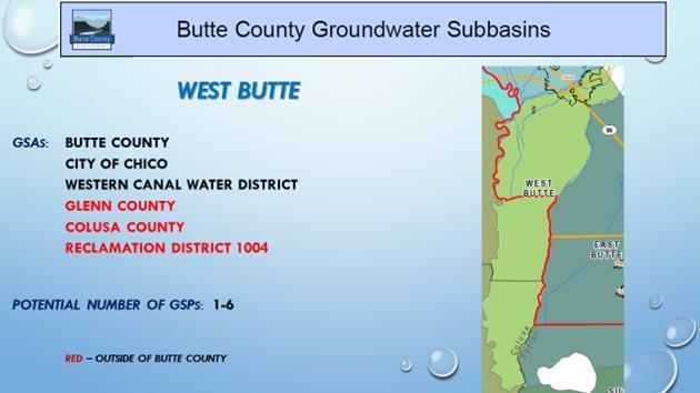
6 Improving Efficiency Maintaining the existing subbasins presents governance and programmatic complexities for local agencies compared to the proposed modification. Butte County and most of the other eligible local public agencies have elected to be GSAs. In each subbasin, the respective GSAs would have to decide on a governance strategy to implement at least one GSP. There would have to be at least 4 GSP and as many as 27. All four subbasins extend into adjoining counties, not only adding to the number of GSAs, but also requiring new relationships (Figure 2). The result may lead to four unique governance structures that require administration, duplication of data, and redundant public participation processes. The basin modification proposal could result in having one GSP for the Butte Basin. Although maintaining the existing subbasins could work, it would be a departure from nearly a two decade approach on how the local agencies in Butte County have collaborated on water resource management. A preferred approach would be to have a subbasin that builds upon the existing local agency technical and programmatic relationships in Butte County. This approach would reduce the number of distinct GSA governance structures and commensurate GSP planning processes. Some of the specific challenges addressed by the basin boundary modification include: Vina -The Vina subbasin extends into Tehama County. Tehama County has eleven subbasins of which eight are subject to SGMA. Six of the eight SGMA subbasins lie exclusively in Tehama County. The Vina subbasin represents the only subbasin in Tehama County that extensively extends into another county. A very small portion of the Colusa subbasin extends into Tehama County. City of Chico -The City of Chico lies in both the Vina and West Butte subbasins. Without any modification, the City of Chico would have to participate in two different GSP processes. Additionally, the corresponding GSPs could face technical challenges in differentiating the water budget for the City of Chico between the two subbasins. Combining the Vina and West Butte subbasins would put the City of Chico in a single subbasin. Western Canal Water District - The Western Canal Water District (WCWD) overlies the West Butte and East Butte subbasins. WCWD extends into Glenn County. Without any modification to basin boundaries, WCWD would have to be involved in two GSP processes. Their water budget would have to be accounted for separately on a subbasin basis. The proposed basin boundary modification would not resolve having WCWD extend into the basin adjoining the Butte subbasin. A solution could involve retaining the WCWD boundary in the Butte subbasin. This would bring WCWD into one GSP planning unit. P a g e 5
7 West Butte - The West Butte subbasin extends into Glenn and Colusa Counties and is bounded in the west by the Sacramento River. The portion of the West Butte subbasin in Glenn County includes part of the WCWD and unincorporated land. The portion of the West Butte subbasin in Colusa County includes RD 1004 and unincorporated land. The modification along the county line would allow the local agencies in Butte, Glenn and Colusa counties to participate on their respective GSPs. Butte Creek represents the boundary between the West Butte and East Butte subbasins. However, these two subbasins are hydrogeologically connected. Developing a GSP for each subbasin would be highly inefficient. East Butte - The East Butte subbasin extends into Sutter County. It includes unincorporated portions of Sutter County. A small portion of the Biggs West Gridley Water District (BWG) extends into Sutter County. About one third of the Butte Water District extends into Sutter County. Without any changes, the East Butte subbasin would include Sutter County, Sutter Extension Water District and the City of Live Oak. Water management, programs and county ordinances differ between Butte and Sutter Counties. Modifying the basin boundary along the county line will avoid unnecessary conflict and challenges in forming a governance structure. North Yuba - The North Yuba subbasin extends into Yuba County. Honcut Creek is the boundary between Butte and Yuba Counties. The Yuba County Water Agency (YCWA), the Cordua Water Agency and the City of Marysville are the GSAs in the Yuba County portion of the North Yuba subbasin. A small portion of three members of the YCWA extend into Butte County. Water management for these districts is led by YCWA, however, the parcels in Butte County fall under Butte County land use and well permitting jurisdiction. The proposed basin modification would follow the county line bisecting the North Yuba subbasin except where portions of the YCWA member agencies extend into Butte County. In this area, the new basin boundary would follow the YCWA member agencies jurisdictional boundary excluding them from the newly created Butte subbasin. Groundwater Management Plans For over a decade, Butte County, the water districts and the urban water suppliers have administered their respective Groundwater Management Plans, Agricultural Water Management Plans and/or Urban Water Management Plans. The agencies have collaborated on the development and implementation of their respective plans. These plans cover the jurisdictional boundaries of the agencies in a manner consistent with the proposed basin modification. As described in the following section, the basin modification would be consistent with the Basin Management Objective program administered by Butte County on behalf of the entire county. The Basin Management Objective program is not structured by the existing subbasins but rather by the Butte Basin. P a g e 6
8 Butte Basin Groundwater Model/Water Budgets - The basin modification would allow for an efficient utilization of the Butte Basin Groundwater Model (BBGM) for the continued development of water budgets and analysis of basin conditions. In the early 1990s, the Butte Basin Water Users Association (BBWUA) developed the BBGM. The BBGM domain includes the full extent of the four subbasins: Vina, East Butte, West Butte and North Yuba. The BBGM can be a useful planning tool for developing GSPs within these four subbasins. Recent updates to the BBGM include extending the model time period to 2014 to produce water budgets for Butte County. In addition, the updated model uses recent versions of the modeling code, IWFM-2015 and IDC v.4.0. The BBGM provides a technical framework to analyze the four subbasin area as a whole or any defined combination or subset(s) of them. Currently, the BBGM has 34 specified subregions for which water budgets and model outputs can be analyzed. These largely correspond to the County s Basin Management Objectives sub-inventory units. They generally correspond to water district boundaries or areas having similar land or water management characteristics. From the standpoint of governance, this supports analysis and potential reporting requirements based on existing jurisdictional boundaries. Since the model domain encompasses the entire four subbasin area, with minimal effort, the model can be used to analyze any revised subset of the model domain. It can also be used to understand groundwater dynamics between defined sub-regions. This has value for understanding and quantifying groundwater flows between defined subbasins. In addition, data from Urban Water Management Plans are incorporated into the BBGM and distinct sub-regions of the model area corresponding to municipality jurisdictions could be defined. In summary, the BBGM organizes data and provides a framework for the integrated groundwater-surface water system for the four subbasin area. For analysis and reporting purposes, the model domain could be carved up in any number of ways to produce water budgets for newly defined or existing subbasins. Providing Input The Department requests that comments including resolutions of support, opposition or modification be submitted by February 15, 2016 by either (BCWater@buttecounty.net) or by mail to Butte County Department of Water and Resource Conservation, 308 Nelson Avenue, Oroville, CA 95965, Attn: Basin Boundaries. P a g e 7
9 Figure 1: Butte Basin Butte Basin GSAs: Butte County, the City of Chico, the City of Biggs, the City of Gridley, the City of Oroville, Western Canal Water District, Richvale Irrigation District, Biggs West Gridley Water District, Butte Water District, Thermalito Water and Sewer District and Butte College Potential Number of GSPs: 1-11 P a g e 8


10 Figure 2: Existing Subbasins and GSAs P a g e 9
COUNTY OF GLENN BOARD REPORT. Submitted by Department of Agriculture
 COUNTY OF GLENN BOARD REPORT Submitted by Department of Agriculture EXECUTIVE SUMMARY: There are three subbasins in Glenn County required to be managed under the Sustainable Groundwater Management Act
Butte County Board of Supervisors Agenda Transmittal
 Butte County Board of Supervisors Agenda Transmittal Clerk of the Board Use Only Agenda Item: 3.38 Subject: Resolution to Establish the Butte County Groundwater Sustainability Agency in the West Butte
City Council Agenda Report
 Crl Ya, CHICO City Council Agenda Report Meeting Date: 217117 TO: City Council FROM: Erik Gustafson, Public Works Director-O&M, (894-4202) RE: CONSIDERATION OF A MEMORANDUM OF UNDERSTANDING FOR THE VINA
Delta-Mendota Groundwater Subbasin
 Delta-Mendota Groundwater Subbasin SGMA Frequently Asked Questions Sustainable Groundwater Management Act What is the Sustainable Groundwater Management Act? The Sustainable Groundwater Management Act,
Merced Groundwater Sustainability Plan. Public Meeting August 2, 2018
 Merced Groundwater Sustainability Plan Public Meeting August 2, 2018 Agenda Welcome and Introductions Sustainable Groundwater Management Act Purpose and Requirements Groundwater Sustainability Plan Timeline
Shasta Valley Groundwater Basin Boundary Modification
 Shasta Valley Groundwater Basin Boundary Modification Sustainable Groundwater Management Act (SGMA) September 2014 Governor Brown signs legislation requiring groundwater resources be managed by local agencies
COUNTY OF SACRAMENTO CALIFO IA
 APP,,tovED MAIO OF SVIDERVISORS 1 ivo, W0,7-02 0 A 11 2017 Lit/ficfr ' By Clerk of the Board COUNTY OF SACRAMENTO CALIFO IA 71 For the Agenda of: April 11,2017 2:00 PM To: From: Subject: Supervisorial
Technical Memorandum. 1 Study Area. Interbasin Groundwater Flow Evaluation
 Technical Memorandum Interbasin Groundwater Flow Evaluation Subject: Prepared For: Butte County Department of Water and Resource Conservation Prepared by: Sara Miller and Craig Altare, P.G. Reviewed by:
East Bay Plain Basin. EBMUD & City of Hayward. Groundwater Reliability Partnership Meeting March 22, 2017
 East Bay Plain Basin EBMUD & City of Hayward Groundwater Reliability Partnership Meeting March 22, 2017 Agenda Overview of the East Bay Plain Basin EBMUD s Bayside Groundwater Project EBMUD s Activities
WHITE WOLF GSA ACCOMPLISHMENTS AND SHORT-TERM SGMA COMPLIANCE GOALS
 WHITE WOLF GSA ACCOMPLISHMENTS AND SHORT-TERM SGMA COMPLIANCE GOALS 22 AUGUST 2017 OUTLINE SGMA Compliance Timeline Accomplishments to Date SGMA Road Map for the White Wolf Subbasin 2042 2022 2017 2016
Napa Valley Groundwater Sustainability: A Basin Analysis Report for the Napa Valley Subbasin
 Napa Valley Groundwater Sustainability: A Basin Analysis Report for the Napa Valley Subbasin A report prepared pursuant to California Water Code Section 10733.6(b)(3) EXECUTIVE SUMMARY (354.4(A)) 1 1.0
Santa Clara Valley Water District Page 1 of 4
 Santa Clara Valley Water District File No.: 16-0304 Agenda Date: 5/24/2016 Item No.: 2.7. BOARD AGENDA MEMORANDUM SUBJECT: Public Hearing and Resolution on the Decision to Become the Groundwater Sustainability
Tule Subbasin: Sustainable Groundwater Management Act (SGMA) August 24, 2016 David De Groot, Professional Engineer 4Creeks, Inc.
 August 24, 2016 David De Groot, Professional Engineer 4Creeks, Inc.") Tule Subbasin: Sustainable Groundwater Management Act (SGMA) August 24, 2016 David De Groot, Professional Engineer 4Creeks, Inc. Overview 1 SUSTAINABLE GROUNDWATER MANAGEMENT ACT 2 TECHNICAL OVERVIEW OF
Tule Subbasin: Sustainable Groundwater Management Act (SGMA) August 24, 2016 David De Groot, Professional Engineer 4Creeks, Inc. Overview 1 SUSTAINABLE GROUNDWATER MANAGEMENT ACT 2 TECHNICAL OVERVIEW OF
WEST TURLOCK SUBBASIN GROUNDWATER SUSTAINABILITY AGENCY. December 13, :00 PM Regular Meeting
 WEST TURLOCK SUBBASIN GROUNDWATER SUSTAINABILITY AGENCY December 13, 2018-6:00 PM Regular Meeting Turlock Irrigation District, Board Room 105 333 E. Canal Drive, Turlock, California AGENDA BOARD MEMBERS
Tehama County Groundwater Sustainability Agency Groundwater Commission
 Tehama County Groundwater Sustainability Agency Groundwater Commission Wednesday, April 25, 2018 8:30 AM Tehama County Board of Supervisors Chambers 727 Oak Street, Red Bluff, CA 96080 http://www.tehamacountypublicworks.ca.gov/flood/
Draft. Butte County Long-Term Regional Growth Forecasts
 Draft Butte County Long-Term Regional Growth Forecasts 2014 2040 Prepared by: November 25 th, 2014 2580 Sierra Sunrise Terrace, Suite 100 Chico, CA 95928 Phone: 530-879-2468 FAX: 530-879-244 www.bcag.org
Stanislaus County Water Advisory Committee. May 30, 2018
 Stanislaus County Water Advisory Committee May 30, 2018 2018 Hydrologic Conditions and Water Supply Outlook 2018 Water Allocations WEST Federal 45% State 35% CCID 100% EAST SSJID 100% OID
Butte County Drought Task Force December 1, :00 AM noon 202 Mira Loma Drive, Tahoe Room Oroville, CA. Agenda
 WATER AND RESOURCE CONSERVATION 308 Nelson Avenue, Oroville, CA 95965 Telephone: (530) 538-4343 Fax: (530) 538-3807 www.buttecounty.net/waterandresource bcwater@buttecounty.net Paul Gosselin, Director
Water Supply and Service Areas of Water Suppliers
 Chapter 4 Water Supply and Service Areas of Water Suppliers Historical Background The Butte Creek Watershed is situated in an area generally considered to have sufficient water to supply both agriculture
S A N M AT E O P L A I N G R O U N D W AT E R B A S I N A S S E S S M E N T S TA K E H O L D E R W O R K S H O P # 4 D E C E M B E R 6,
 S A N M AT E O P L A I N G R O U N D W AT E R B A S I N A S S E S S M E N T S TA K E H O L D E R W O R K S H O P # 4 D E C E M B E R 6, 2 0 1 6 PRESENTATION OVERVIEW Introductions Project Overview Review
DRAFT. REVISED Draft. Paso Robles Subbasin Groundwater Sustainability Plan Chapter 6
 REVISED Draft Paso Robles Subbasin Groundwater Sustainability Plan Chapter 6 Prepared for the Paso Robles Subbasin Cooperative Committee and the Groundwater Sustainability Agencies February 14, 2019 Paso
COUNTY OF SAN LUIS OBISPO BOARD OF SUPERVISORS AGENDA ITEM TRANSMITTAL
 COUNTY OF SAN LUIS OBISPO BOARD OF SUPERVISORS AGENDA ITEM TRANSMITTAL (1) DEPARTMENT Public Works (2) MEETING DATE 4/9/2019 (3) CONTACT/PHONE Mladen Bandov Senior Water Resources Engineer (805) 781-5116
OREGON POPULATION FORECAST PROGRAM
 OREGON POPULATION FORECAST PROGRAM PROGRAM OVERVIEW BACKGROUND Beginning in 1973 with the passage of Senate Bill (SB) 100, Oregon s growth management system has relied on population forecasts as the primary
Butte County Board of Supervisors Agenda Transmittal
 Clerk of the Board Use Only Butte County Board of Supervisors Agenda Transmittal Agenda Item: 3.03 Subject: County Service Area Service and Permanent Road Division Charges for Fiscal Year 2013-14 Department:
Facts and Findings. Exhibit A-1
 Exhibit A-1 Facts and Findings The county periodically prepares coordinated countywide forecasts for all the cities in the county and the unincorporated area. These forecasts can be used by cities as a
TECHNICAL MEMORANDUM: MADERA SUBBASIN. Sustainable Groundwater Management Act (SGMA) DRAFT PRELIMINARY BASIN BOUNDARY WATER BUDGET.
 DRAFT PRELIMINARY BASIN BOUNDARY WATER BUDGET.") TECHNICAL MEMORANDUM: MADERA SUBBASIN Sustainable Groundwater Management Act (SGMA) DRAFT PRELIMINARY BASIN BOUNDARY WATER BUDGET Prepared by February 2018 DRAFT PRELIMINARY Technical Memorandum: Madera
TECHNICAL MEMORANDUM: MADERA SUBBASIN Sustainable Groundwater Management Act (SGMA) DRAFT PRELIMINARY BASIN BOUNDARY WATER BUDGET Prepared by February 2018 DRAFT PRELIMINARY Technical Memorandum: Madera
SOLANO SUBBASIN GROUNDWATER SUSTAINABILITYAGENCY
 SOLANO SUBBASIN GROUNDWATER SUSTAINABILITYAGENCY BOARD OF DIRECTORS: Chair: Supervisor Skip Thomson Solano County District 5 Vice Chair: BOARD OF DIRECTORS MEETING DATE: Thursday, April 12, 2018 Vice-Mayor
2018/1 The integration of statistical and geospatial information. The Regional Committee of UN-GGIM: Americas:
 The following are the conclusions and recommendations of the Regional Committee of the United Nations on Global Geospatial Information Management for the Americas, during its Fifth Session, Thursday 8
COUNTY OF SONOMA PERMIT AND RESOURCE MANAGEMENT DEPARTMENT 2550 Ventura Avenue, Santa Rosa, CA (707) FAX (707)
 FAX (707)") COUNTY OF SONOMA PERMIT AND RESOURCE MANAGEMENT DEPARTMENT 2550 Ventura Avenue, Santa Rosa, CA 95403 (707) 565-1900 FAX (707) 565-1103 DATE : TO: FROM: SUBJECT: July 21, 2009 at 2:30 p.m. Board of Supervisors
COUNTY OF SONOMA PERMIT AND RESOURCE MANAGEMENT DEPARTMENT 2550 Ventura Avenue, Santa Rosa, CA 95403 (707) 565-1900 FAX (707) 565-1103 DATE : TO: FROM: SUBJECT: July 21, 2009 at 2:30 p.m. Board of Supervisors
Napa Valley Groundwater Sustainability: A Basin Analysis Report for the Napa Valley Subbasin
 Napa Valley Groundwater Sustainability: A Basin Analysis Report for the Napa Valley Subbasin December 13, 2016 Napa County Board of Supervisors By Vicki Kretsinger Grabert and Reid Bryson Basin Analysis
Internal Audit Report
 Internal Audit Report Right of Way Mapping TxDOT Internal Audit Division Objective To determine the efficiency and effectiveness of district mapping procedures. Opinion Based on the audit scope areas reviewed,
Proposed Scope of Work Village of Farmingdale Downtown Farmingdale BOA Step 2 BOA Nomination Study / Draft Generic Environmental Impact Statement
 Proposed Scope of Work Village of Farmingdale Downtown Farmingdale BOA Step 2 BOA Nomination Study / Draft Generic Environmental Impact Statement The scope of work that follows incorporates and covers
Philip A. Ginsburg, General Manager Dawn Kamalanathan, Director, Capital & Planning Division
 Date June 3, 2015 To: Through: From: Subject: Recreation and Park Commission Capital Committee Philip A. Ginsburg, General Manager Dawn Kamalanathan, Director, Capital & Planning Division Stacy Bradley,
Annual PHA Plan. Effective July 1, 2017 June 30, Decatur Housing Authority
 Decatur Housing Authority Annual PHA Plan Effective July 1, 2017 June 30, 2018 Decatur Housing Authority 7315 Hanna Street Fort Wayne, IN 46816 Phone: (260) 267-9300 Website: www.fwha.org PHA Plan Attachments
Derogation Criteria for the Requirements for Generators Network Code
 Derogation Criteria for the Requirements for Generators Network Code Decision Paper Reference: CER/17/084 Date Published: 13/04/2017 Closing Date: 0 Executive Summary Commission Regulation (EU) 2016/631
City of Manitou Springs
 March 2018 City of Manitou Springs Implementing Land Use tools to reduce and mitigate natural hazard risk Context & History Past Present Historic homes Older infrastructure Hillside development Creekside
Technical Memorandum. Agricultural Water Demand Forecast
 A Butte County Department of Water and Resource Conservation Integrated Watershed and Resource Conservation Plan Agricultural Water Demand Forecast October 2003 Technical Memorandum Butte County Department
COMMUNITY DEVELOPMENT DEPARTMENT POLICY & PROCEDURE
 COMMUNITY DEVELOPMENT DEPARTMENT POLICY & PROCEDURE Policy No: DSP-OO3 Release Date: January 1, 2014 Effective Date: January 1, 2014 Revision Date: March 1, 2018 TITLE: The City Policy for Site Specific
C2VSim Fine Grid (C2VSim-FG) Version Development & Applications
 Version Development & Applications") C2VSim Fine Grid (C2VSim-FG) Version Development & Applications 2014 CWEMF Annual Meeting February 24, 2014 Presenters: Ali Taghavi & Mesut Cayar Collaborators: Reza Namvar (RMC), Jim Blanke (RMC), Tariq
C2VSim Fine Grid (C2VSim-FG) Version Development & Applications 2014 CWEMF Annual Meeting February 24, 2014 Presenters: Ali Taghavi & Mesut Cayar Collaborators: Reza Namvar (RMC), Jim Blanke (RMC), Tariq
CORPORATION OF THE CITY OF COURTENAY COUNCIL MEETING AGENDA
 CORPORATION OF THE CITY OF COURTENAY COUNCIL MEETING AGENDA DATE: Monday, January 14, 2013 PLACE: City Hall Council Chambers TIME: 4:00 p.m. 1.00 ADOPTION OF MINUTES 1. Adopt January 7, 2013 Regular Council
TECHNICAL PUBLICATION SJ WATER SUPPLY ASSESSMENT 2003 ST. JOHNS RIVER WATER MANAGEMENT DISTRICT
 TECHNICAL PUBLICATION SJ2006-1 WATER SUPPLY ASSESSMENT 2003 ST. JOHNS RIVER WATER MANAGEMENT DISTRICT Technical Publication SJ2006-1 Water Supply Assessment 2003 Palatka, Florida 2006 Northwest Florida
4.12 Mineral Resources
 4.12.1 Setting Section 2.2, Project Location, provides general information about the Project s regional and local setting. This Section 4.12.1 provides setting information specific to mineral resources.
Feather River Regional Plan Operation and Maintenance Governance Study DRAFT September 26, Project Background:
 Feather River Regional Plan Operation and Maintenance Governance Study DRAFT September 26, 2016 Project Background: The Regional Partners, comprised of the Yuba County Water Agency (YCWA), Three Rivers
State GIS Officer/GIS Data
 State GIS Officer/GIS Data This Act creates the position of state Geographic Information Systems (GIS) officer. The Act: requires the state GIS officer to adopt or veto the GIS data standards and a statewide
Merced Subbasin Groundwater Sustainability Agency Governing Board
 Merced Subbasin Groundwater Sustainability Agency Governing Board County of Merced Board Chambers, Third Floor 2222 M Street, Merced, California Regular Meeting July 13, 2017 2:00PM AGENDA Bob Kelley,
Exhibit IV-1: Initiation of Zoning Map Amendments Case Report HEARING DATE: MAY 3, 2012
 Exhibit IV-1: Initiation of Zoning Map Amendments Case Report HEARING DATE: MAY, 01 Case No.: 00.0MTZU Transit Center District Plan Amendments to Zoning Map Staff Contact: Joshua Switzky - (1) -1 joshua.switzky@sfgov.org
Boundary and Annexation Survey (BAS)
") Boundary and Annexation Survey (BAS) New Mexico SDC Meeting Chris Wingate Geography Division U.S. Census Bureau 1 Agenda Boundary and Annexation Survey (BAS) BAS Overview American Community Survey (ACS)
Boundary and Annexation Survey (BAS) New Mexico SDC Meeting Chris Wingate Geography Division U.S. Census Bureau 1 Agenda Boundary and Annexation Survey (BAS) BAS Overview American Community Survey (ACS)
Current Status of Program for Geological Disposal of high-level radioactive waste (HLW) in Japan 1
 in Japan 1") Current Status of Program for Geological Disposal of high-level radioactive waste (HLW) in Japan 1 Shunsuke Kondo, Dr. President The Nuclear Waste Management Organization of Japan (NUMO) In Japan, the
Current Status of Program for Geological Disposal of high-level radioactive waste (HLW) in Japan 1 Shunsuke Kondo, Dr. President The Nuclear Waste Management Organization of Japan (NUMO) In Japan, the
CITY OF PAPILLION PLANNING COMMISSION STAFF REPORT MAY 27, 2015 AGENDA 2015 ANNEXATION MISC
 PLANNING COMMISSION STAFF REPORT MAY 27, 2015 AGENDA 2015 ANNEXATION MISC-15-0005 I. GENERAL INFORMATION A. APPLICANT: City of Papillion 122 East Third St. Papillion, NE 68046 B. LEGAL DESCRIPTION: See
3.11 Floodplains Existing Conditions
 Other stormwater control practices may be needed to mitigate water quality impacts. In addition to detention facilities, other practices such as vegetated basins/buffers, infiltration basins, and bioswales
DRAFT. Chapters 1, 2, 3 Paso Robles Subbasin Groundwater Sustainability Plan
 Chapters 1, 2, 3 Paso Robles Subbasin Groundwater Sustainability Plan Published on: Received by the Paso Basin Cooperative Committee: July 25, 2018 Posted on PasoGCP.com: August 31, 2018 Close of 45 day
Report to the Seventy-first Legislative Assembly on the Implementation of 1999 Senate Bill 12 Relating to Public Safety and Rapidly Moving Landslides
 Report to the Seventy-first Legislative Assembly on the Implementation of 1999 Senate Bill 12 Relating to Public Safety and Rapidly Moving Landslides December 28, 2000 Department of Geology and Mineral
Streamlined Annual PHA Plan (Small PHAs)
") Streamlined Annual PHA Plan (Small PHAs) U.S. Department of Housing and Urban Development Office of Public and Indian Housing OMB No. 2577-0226 Expires: 02/29/2016 Purpose. The 5-Year and Annual PHA Plans
Streamlined Annual PHA Plan (Small PHAs) U.S. Department of Housing and Urban Development Office of Public and Indian Housing OMB No. 2577-0226 Expires: 02/29/2016 Purpose. The 5-Year and Annual PHA Plans
Date: June 19, 2013 Meeting Date: July 5, Consideration of the City of Vancouver s Regional Context Statement
 Section E 1.5 To: From: Regional Planning and Agriculture Committee Lee-Ann Garnett, Senior Regional Planner Planning, Policy and Environment Department Date: June 19, 2013 Meeting Date: July 5, 2013 Subject:
WORKFORCE SERVICES DIRECTIVE. This policy officially identifies California s regional planning units.
 WORKFORCE SERVICES DIRECTIVE Attachment C Number: WSD15-17 Date: February 24, 2016 69:175:rc TO: WORKFORCE DEVELOPMENT COMMUNITY SUBJECT: CALIFORNIA WIOA REGIONAL PLANNING UNITS EXECUTIVE SUMMARY Purpose
Draft Model Memorandum of Understanding to promote voluntary cooperation between Government and Chemical Industry to enhance Precursors Chemicals
 Draft Model Memorandum of Understanding to promote voluntary cooperation between Government and Chemical Industry to enhance Precursors Chemicals Control 1 Introduction There has been growing recognition
REVISED UPDATED PREPARED DIRECT SAFETY ENHANCEMENT COST ALLOCATION TESTIMONY OF GARY LENART SAN DIEGO GAS & ELECTRIC COMPANY AND
 Application No: Exhibit No.: Witness: A.--00 ) In the Matter of the Application of San Diego Gas & ) Electric Company (U 0 G) and Southern California ) Gas Company (U 0 G) for Authority to Revise ) Their
APPENDIX A M&T/Llano Seco Long-Term Water Reliability Study These photos are examples of rock spurs in use throughout the United States
 APPENDIX A M&T/Llano Seco Long-Term Water Reliability Study These photos are examples of rock spurs in use throughout the United States Glenn Colusa Irrigation District completed a Sacramento River project
9. GEOLOGY, SOILS, AND MINERALS
 June 28, 2018 Page 9-1 9. GEOLOGY, SOILS, AND MINERALS This EIR chapter describes the existing geological, soil, and mineral conditions in the planning area. The chapter includes the regulatory framework
Planning Commission Report
 QX f BEVERLY HILLS City of Beverly Hills Planning Division 455 N. Rexford Drive Beverly Hills, CA 90210 TEL. (310) 285-1141 FAX. (310) 858-5966 Meeting Date: Subject: Project Applicant: Recommendation:
Albuquerque City-wide Zoning Remapping
 Albuquerque City-wide Zoning Remapping Michelle Gricius, City of Albuquerque Planning Department Albuquerque Geographic Information System (AGIS) Division City of Albuquerque Annexation History Albuquerque
APPLICATION FOR CONDITIONAL ABSOLUTE WATER STORAGE RIGHT
 District Court, Water Division, Colorado Court Address: CONCERNING THE APPLICATION FOR WATER RIGHTS OF Applicant: In the River or its Tributaries In COUNTY Attorney or Party Without Attorney (Name and
Chapter 10 MOVING WITH CONTINUED ASSISTANCE AND PORTABILITY
 INTRODUCTION Chapter 10 MOVING WITH CONTINUED ASSISTANCE AND PORTABILITY Freedom of choice is a hallmark of the housing choice voucher (HCV) program. In general, therefore, HUD regulations impose few restrictions
GIS ADMINISTRATOR / WEB DEVELOPER EVANSVILLE-VANDERBURGH COUNTY AREA PLAN COMMISSION
 GIS ADMINISTRATOR / WEB DEVELOPER EVANSVILLE-VANDERBURGH COUNTY AREA PLAN COMMISSION SALARY RANGE INITIATION $43,277 SIX MONTHS $45,367 POSITION GRADE PAT VI The Evansville-Vanderburgh County Area Plan
Sacramento River Bank Protection Project
 2005 - FIELD RECONNAISSANCE REPORT OF BANK EROSION SITES - SACRAMENTO RIVER FLOOD CONTROL LEVEES AND TRIBUTARIES Sacramento River Bank Protection Project Project No. 32-0530.10, Task 3 Prepared for: U.S.
Name of Applicant Mailing Address address Telephone Number
 District Court, Water Division, Colorado Court Address: CONCERNING THE APPLICATION FOR WATER RIGHTS OF Applicant: In the River or its Tributaries In COUNTY Attorney or Party Without Attorney (Name and
Extreme Temperature Protocol in Middlesex-London
 Clean Air Partnership Webinar March 17, 2009 Extreme Temperature Protocol in Middlesex-London Presented by Iqbal Kalsi, MBA, CPHI(C), CCEP iqbal.kalsi@mlhu.on.ca 1 History Informal monitoring, tracking
PLANNING COMMISSION AGENDA
 COUNTY OF IMPERIAL COMMISSIONERS: Chairman: Rudy Schaffner Dennis Bergh Norm Niver Vice Chairman: Carson Kalin Sergio Cabanas Russell Roben Max Castillo Carlton A. Hargrave Ernesto Medina JIM MINNICK,
Dark Sky Initiative Draft Terms of Reference
 Dark Sky Initiative Draft Terms of Reference July 2008 Table of Contents 1.0 Introduction 2 2.0 Initiative intent 2-3 3.0 Initiative goals 3 4.0 Legislation 3 5.0 Municipal Development Plan 3 6.0 Land
Chapter 2: Description of Planning Area
 2020 Facilities Plan Facilities Plan Report Chapter 2: Description of Planning Area 2.1 Introduction This chapter describes Milwaukee Metropolitan Sewerage District s (MMSD) planning area and existing
April 10, Mr. Curt Van De Walle, City Manager City of Castle Hills 209 Lemonwood Drive Castle Hills, Texas 78213
 Mr. Curt Van De Walle, City Manager City of Castle Hills 209 Lemonwood Drive Castle Hills, Texas 78213 Subject: Revised Castle Hills BASIS Charter School Traffic Impact Analysis Review City of Castle Hills,
Proposal for a DIRECTIVE OF THE EUROPEAN PARLIAMENT AND OF THE COUNCIL. establishing an infrastructure for spatial information in the Community
 Proposal for a DIRECTIVE OF THE EUROPEAN PARLIAMENT AND OF THE COUNCIL establishing an infrastructure for spatial information in the Community INSPIRE http://inspire.jrc.it/ Alessandro Annoni 1 EU Commission
Rural Pennsylvania: Where Is It Anyway? A Compendium of the Definitions of Rural and Rationale for Their Use
 Rural Pennsylvania: Where Is It Anyway? A Compendium of the Definitions of Rural and Rationale for Their Use Pennsylvania Office of Rural Health 310 Nursing Sciences Building University Park, PA 16802
State initiative following up the 2006 national planning report
 18 ness districts and public institutions, should be integrated with the opportunities for public transport services. State initiative following up the 2006 national planning report The Ministry of the
The World Bank Indonesia National Slum Upgrading Project (P154782)
") Public Disclosure Authorized EAST ASIA AND PACIFIC Indonesia Social, Urban, Rural and Resilience Global Practice Global Practice IBRD/IDA Investment Project Financing FY 2017 Seq No: 4 ARCHIVED on 04-Apr-2018
Public Disclosure Authorized EAST ASIA AND PACIFIC Indonesia Social, Urban, Rural and Resilience Global Practice Global Practice IBRD/IDA Investment Project Financing FY 2017 Seq No: 4 ARCHIVED on 04-Apr-2018
Landreport Sweden
 L A N T M Ä T E R I E T 1 (7) 2016-05-25 v 1.0 Landreport Sweden 2015-2016 1. The Address register current situation The number of addresses is about 3.7 million. The updating runs for good, but there
Law on Spatial Planning
 UNITED NATIONS United Nations Interim Administration Mission in Kosovo UNMIK NATIONS UNIES Mission d Administration Intérimaire des Nations Unies au Kosovo PROVISIONAL INSTITUTIONS OF SELF GOVERNMENT Law
Sacramento Valley Groundwater Basin, Sutter Subbasin
 Sacramento Valley Groundwater Basin, Sutter Subbasin Groundwater Basin Number: 5-21.62 County: Sutter Surface Area: 234,400 acres (366 square miles) Boundaries and Hydrology The Sutter Subbasin lies in
The Swedish National Geodata Strategy and the Geodata Project
 The Swedish National Geodata Strategy and the Geodata Project Ewa Rannestig, Head of NSDI Co-ordination Unit, Lantmäteriet, ewa.rannstig@lm.se Ulf Sandgren, Project Manager Geodata Project, Lantmäteriet,
HAMILTON DECLARATION ON COLLABORATION FOR THE CONSERVATION OF THE SARGASSO SEA
 HAMILTON DECLARATION ON COLLABORATION FOR THE CONSERVATION OF THE SARGASSO SEA Hamilton, Bermuda 11 March, 2014 WE, THE SIGNATORIES LISTED BELOW: Recognising that the islands of Bermuda are the only land
Study Overview. the nassau hub study. The Nassau Hub
 Livable Communities through Sustainable Transportation the nassau hub study AlternativeS analysis / environmental impact statement The Nassau Hub Study Overview Nassau County has initiated the preparation
2001 ANNUAL REPORT on INTERBASIN TRANSFERS for RTP South and the Towns of Cary, Apex, and Morrisville
 2001 ANNUAL REPORT on INTERBASIN TRANSFERS for RTP South and the Towns of Cary, Apex, and Morrisville Prepared for: Town of Cary Town of Apex Town of Morrisville RTP South/Wake County Submitted to: North
Natura 2000 and spatial planning. Executive summary
 Natura 2000 and spatial planning Executive summary DISCLAIMER The information and views set out in this study are those of the author(s) and do not necessarily reflect the official opinion of the Commission.
Nanomaterials, REACH and CLP - what is going on at the regulatory front
 Nanomaterials, REACH and CLP - what is going on at the regulatory front NanoKokkola 23 September 2014 Outi Tunnela Helpdesk Unit European Chemicals Agency EU Approach to Nanotechnologies Safe: ensure a
The Dance Hall Goes in What School District?
 The Dance Hall Goes in What School District? Vern C. Svatos Jarrod S. Doucette Abstract This paper presents the results of a GIS mapping effort created for the Delaware State Department of Education using
Digital Mapping License Agreement
 City of Des Moines, Iowa GIS Division, Information Technology Department Digital Mapping License Agreement PURPOSE AND NATURE OF THE AGREEMENT This Digital Mapping License Agreement ("Agreement") is executed
TREASURE COAST REGIONAL PLANNING COUNCIL M E M O R A N D U M. To: Council Members AGENDA ITEM 4B10
 TREASURE COAST REGIONAL PLANNING COUNCIL M E M O R A N D U M To: Council Members AGENDA ITEM 4B10 From: Date: Subject: Staff December 14, 2018 Council Meeting Local Government Comprehensive Plan Review
Edward R. Sajecki Commissioner of Planning and Building. Conservation Authority Regulations and Mapping
 Corporate Report Clerk s Files Originator s Files EC.19.CON DATE: TO: FROM: SUBJECT: Chair and Members of Planning and Development Committee Meeting Date: April 3, 2006 Edward R. Sajecki Commissioner of
GUIDELINE: SD/GN/03 Last Updated on February 19, Application of Policy on Agency Minimum Standards on Environmental and Social Safeguards
 GUIDELINE: SD/GN/03 Last Updated on February 19, 2015 Application of Policy on Agency Minimum Standards on Environmental and Social Safeguards Summary: This Guideline explains how the GEF will assess the
POLICY ISSUE (INFORMATION)
") POLICY ISSUE (INFORMATION) August 12, 2011 SECY-11-0112 FOR: FROM: SUBJECT: The Commissioners Michael R. Johnson, Director /RA/ Office of New Reactors STAFF ASSESSMENT OF SELECTED SMALL MODULAR REACTOR
POLICY ISSUE (INFORMATION) August 12, 2011 SECY-11-0112 FOR: FROM: SUBJECT: The Commissioners Michael R. Johnson, Director /RA/ Office of New Reactors STAFF ASSESSMENT OF SELECTED SMALL MODULAR REACTOR
MPOs SB 375 LAFCOs SCAG Practices/Experiences And Future Collaborations with LAFCOs
 Connecting LAFCOs and COGs for Mutual Benefits MPOs SB 375 LAFCOs SCAG Practices/Experiences And Future Collaborations with LAFCOs Frank Wen, Manager Research & Analysis Land Use & Environmental Planning
National Land Use Policy and National Integrated Planning Framework for Land Resource Development
 Title National Land Use Policy and National Integrated Planning Framework for Land Resource Development Duration: 32 Weeks Objective: Adoption of appropriate land use planning approaches to: Maintain the
Economic and Social Council
 United Nations Economic and Social Council Distr.: General 18 July 2016 Original: English Committee of Experts on Global Geospatial Information Management Sixth session New York, 3-5 August 2016 Item 2
The 2020 Census Geographic Partnership Opportunities
 The 2020 Census Geographic Partnership Opportunities Web Adams Geographer, U.S. Census Bureau New York Regional Office 1 Geographic Partnership Opportunities The 2020 Census Local Update of Census Addresses
Hydrogeologic Conceptual Models for Regional Flow Systems
 Hydrogeologic Conceptual Models for Regional Flow Systems R.T. Hanson, U.S. Geological Survey One Water Hydrologic Flow Model USGS MODFLOW-OWHM Session 4 Groundwater Subbasin Baseline Historic and Current
INDUSTRIAL MARKET OVERVIEW
 INDUSTRIAL MARKET OVERVIEW Presented to: Metro Vancouver Planning Committee Presented by: Curtis Scott Manager, Market Intelligence Western Roy Pat Industrial Sales & Leasing Canada Vancouver PRESENTATION
1.0 PURPOSE AND FORMAT OF THE FINAL EIR
 1.0 PURPOSE AND FORMAT OF THE FINAL EIR 1.1 PROJECT OVERVIEW CEMEX (RMC Pacific Materials, dba CEMEX) operates the Bonny Doon Shale and Limestone Quarries in Santa Cruz County for the production of Portland
2018 PROCESSOR INVENTORY NOTIFICATION ACTIVE-INACTIVE REQUIREMENTS
 2018 PROCESSOR INVENTORY NOTIFICATION ACTIVE-INACTIVE REQUIREMENTS NOTIFICATION DEADLINE Processor Reporting October 5, 2018 WHAT IS TSCA? REPORTING TIMELINE WHAT IS A PROCESSOR? RETROSPECTIVE REPORTING
Subject: Availability of New and Revised Public Housing Agency (PHA) Five-Year and Annual Plan Templates and Other Forms
 Five-Year and Annual Plan Templates and Other Forms") Special Attention: U.S. Department of Housing and Urban Development Office of Public and Indian Housing Public Housing Agencies (PHA) NOTICE PIH-2015-18 (HA) Public Housing Hub Office Directors Public
Special Attention: U.S. Department of Housing and Urban Development Office of Public and Indian Housing Public Housing Agencies (PHA) NOTICE PIH-2015-18 (HA) Public Housing Hub Office Directors Public
Large Scale Mapping Policy for the Province of Nova Scotia
 Large Scale Mapping Policy for the Province of Nova Scotia December, 2005 Version 1.0 TABLE OF CONTENTS PAGE BACKGROUND...3 POLICY...5 Policy 1.0 Large Scale Mapping Program...5 Policy 2.0 Service Offering...5