DFO Maritimes Region Update. Gulf of Maine Council - Coastal and Marine Spatial Planning (CMSP) Committee Web-Ex May 16, 2017
|
|
|
- Douglas Barber
- 5 years ago
- Views:
Transcription
1 DFO Maritimes Region Update Gulf of Maine Council - Coastal and Marine Spatial Planning (CMSP) Committee Web-Ex May 16,
2 National Oceans Priorities Marine Conservation Targets Oceans Protection Plan Oceans Management Outline Regional Oceans Plan MPA Network Development Environmental Response Planning Marine Planning Tools Governance 2
3 Marine Conservation Targets (MCT) Minister of Fisheries, Oceans and Canadian Coast Guard s Mandate Letter: Work with the Minister of Environment and Climate Change to increase the proportion of Canada s marine and coastal areas that are protected to 5% percent by 2017 and to 10% by United Nations Convention on Biological Diversity: By % of coastal and marine areas, especially areas of particular importance for biodiversity and ecosystem services, are conserved through effectively and equitably managed, ecologically representative and well connected systems of protected areas and other effective area-based conservation measures, and integrated into the wider landscapes and seascapes. 3
4 MCT Five-Point Plan 1) Finish What Was Started: Advance work already underway in areas progressing towards establishment 2) Protect Pristine Areas: Establish new, large Oceans Act MPAs in offshore areas 3) Protect Areas Under Pressure: Establish additional Oceans Act MPAs in areas under pressure from human activities, for example where we are already advancing MPA network development 4) Advance Other Effective Area-Based Conservation Measures: Identify existing and establish new other measures, such as fisheries closures, particularly to protect sensitive sponge and coral concentrations 5) Establish MPAs Faster: Examine how the Oceans Act can be updated to facilitate the designation process for MPAs, without sacrificing science, or the public s opportunity to provide input. 4
5 5
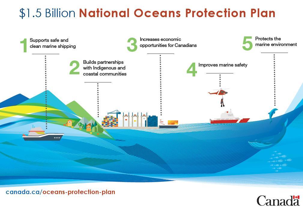
6 Oceans Protection Plan (OPP) Objective is to support safe and clean marine shipping, build partnerships with Indigenous and coastal communities, improve marine safety and protect the marine environment. State-of-the-art marine safety system Vessel traffic monitoring and control Incident preparedness and response Preservation and restoration of marine ecosystem Baseline and environmental effects monitoring Marine stressors (e.g., ship noise and whales, cumulative impacts) Coastal restoration fund Indigenous partnerships Stronger evidence base and increased community participation/public awareness Saint John Harbour and the approaches to the Bay of Fundy are a priority area. 6
7 Oceans Management Minister of Fisheries, Oceans and Canadian Coast Guard s Mandate Letter: Work with the provinces, territories, Indigenous Peoples, and other stakeholders to better co-manage our three oceans. Preliminary funding (2 years) under Oceans Protection Plan: National management strategy and governance development Regional implementation pilot on marine spatial planning (Pacific Region) Intent is to design and move forward with comprehensive national program Key principles: Federal coordination Provincial and Indigenous participation Bioregional implementation Practical outputs (MSP) 7

8 A Regional Oceans Plan for the Scotian Shelf, Atlantic Coast and Bay of Fundy

9 Regional Oceans Plan Structure 9

10 REGIONAL OCEANS PLAN SCOTIAN SHELF ATLANTIC COAST BAY OF FUNDY 10

11 Implementation Priorities MPA Network Development MPA Establishment, Management and Monitoring Environmental Preparedness and Response Planning Implementing Oceans and Coastal Management Measures Using a Risk- Based Approach 11
12 Marine Protected Area Network Development (MCT) Regional contributions to the 2017 interim national target of 5% marine protection on track (see regional map): St. Anns Bank MPA designation expected soon Adjustments to Western/Emerald Banks Conservation Area (the Haddock Box) completed by summer (Resource Management lead) Bioregional network development process proceeding well: Draft bioregional network design nearing completion (coastal and offshore) Targeted engagement on draft design with provincial, Indigenous and key stakeholders during summer General public release in fall, followed by full year of consultation Two new Oceans Act Areas of Interest (AOI) to be identified as part of network and for designation in 2020 Additional Other Effective Measures under Fisheries Act expected

13 Anticipated DFO Contributions to 2017 Marine Conservation Target
14 Environmental Response Planning (OPP) Area response planning (ARP): Support Area Task Force in finalizing draft plans and methodologies, including public and stakeholder engagement process Complete information and map products for Bay of Fundy and Chedabucto Bay pilot areas (work with Science and ECCC) Complete external contracts and G&C agreements Coastal fisheries Lidar ATK Support transition to Regional Response Planning (RRP) Advance existing and new activities, including gap filling (e.g., ATK for NB side of Bay of Fundy) Regional response coordination CANUSLANT 14

15 Marine Planning Tools Marine information, mapping and decision support EBSA site assessments and profiles Marine stressors/environmental quality: Establish capacity and support program definition and scope Initial focus on marine noise and whales, but will be broadened Cumulative impacts 15
16 Governance First Nations and Indigenous Groups - Mi kmaq - Maliseet - Passamaquoddy Federal - Re-organize regional federal coordination table Provincial - Current focus on MCT implementation; potential re-integration with federal table in future Stakeholder - SW New Brunswick Marine Advisory Committee 16
Outline National legislative & policy context Regional history with ESSIM ESSIM Evaluation Phase Government Integration via RCCOM Regional ICOM Framew
 What MSP Implementation could change in the Maritimes Region Tim Hall, Regional Manager Oceans and Coastal Management Division Ecosystem Management Branch Fisheries and Oceans Canada Maritimes Region BIO
Designing Networks of Marine Protected Areas in DFO s Three Atlantic Bioregions
 Designing Networks of Marine Protected Areas in DFO s Three Atlantic Bioregions Presentation for Indigenous Protected Areas Workshop Max Westhead, DFO and Adrian Gerhartz-Abraham, Dalhousie March 29, 2017
Marine Protected Area Network Planning in the Bay of Fundy and Scotian Shelf. Progress to date and next steps
 Marine Protected Area Network Planning in the Bay of Fundy and Scotian Shelf Progress to date and next steps Max(ine) Westhead, M.Sc. Section Head, Protected Areas and Conservation Planning Fisheries and
REGIONAL OCEANS PLAN
 FISHERIES AND OCEANS CANADA MARITIMES REGION 2016 REGIONAL OCEANS PLAN SCOTIAN SHELF ATLANTIC COAST BAY OF FUNDY Progress Report 2014-2016 Fisheries and Oceans Canada Pêches et Océans Canada Implementing
Marine Spatial Planning: A Tool for Implementing Ecosystem-Based Management
 Marine Spatial Planning: A Tool for Implementing Ecosystem-Based Management Steven Murawski, Ph.D., Ecosystem Goal Team Lead National Oceanic and Atmospheric Administration NOAA November 16, 2009 1 To
EASTERN SCOTIAN SHELF INTEGRATED OCEAN MANAGEMENT PLAN
 Government of Canada Gouvernement du Canada EASTERN SCOTIAN SHELF INTEGRATED OCEAN MANAGEMENT PLAN SUMMARY Photo Credits: Bedford Institute of Oceanography Published by: Oceans and Habitat Branch Fisheries
NOAA Nautical Charts and Coastal and Marine Spatial Planning. Meredith Westington Chief Geographer NOAA/NOS/Office of Coast Survey
 NOAA Nautical Charts and Coastal and Marine Spatial Planning Meredith Westington Chief Geographer NOAA/NOS/Office of Coast Survey Ocean Policy Task Force What is CMSP? A comprehensive, adaptive, integrated,
Spatial Planning in Canada s Maritimes Region. Maritimes Region
 Spatial Planning in Canada s Maritimes Region Glen Herbert, Scott Coffen-Smout Smout,, and Tanya Koropatnick Oceans and Coastal Management Division Ecosystem Management Branch Fisheries and Oceans Canada
International Guidelines for Ecosystem-based, Marine Spatial Management
 International Guidelines for Ecosystem-based, Marine Spatial Management Charles Ehler and Fanny Douvere, Consultants Intergovernmental Oceanographic Commission and Man and the Biosphere Programme UNESCO
Country Fiche Estonia
 Country Fiche Estonia Deleted: October Updated May 2018 Deleted: 7 1. General information Size of internal waters (to the baseline) and territorial sea (12-nm zone from the baseline) approximately 25 200
FISHERIES AND OCEANS CANADA MARITIMES REGION 2014 REGIONAL OCEANS PLAN SCOTIAN SHELF ATLANTIC COAST BAY OF FUNDY. Background and Program Description
 FISHERIES AND OCEANS CANADA MARITIMES REGION 2014 REGIONAL OCEANS PLAN SCOTIAN SHELF ATLANTIC COAST BAY OF FUNDY Background and Program Description Fisheries and Oceans Canada Pêches et Océans Canada Fisheries
Introduction: The Gulf of Mexico Alliance. The Gulf GAME project MERMAid and PHINS Results & Conclusions What s next? Examples
 AAG Las Vegas March 25, 2009 Introduction: Ocean governance and Ecosystem-Based Management The Gulf of Mexico Alliance Habitat Identification and Characterization The Gulf GAME project MERMAid and PHINS
Terms of Reference for the Comparative Environmental Review (CER) of. Options for the Mactaquac Project, Mactaquac, New Brunswick
 of. Options for the Mactaquac Project, Mactaquac, New Brunswick") Terms of Reference for the Comparative Environmental Review (CER) of Options for the Mactaquac Project, Mactaquac, New Brunswick Preamble The New Brunswick Power Corporation ( NB Power ) operates the Mactaquac
Terms of Reference for the Comparative Environmental Review (CER) of Options for the Mactaquac Project, Mactaquac, New Brunswick Preamble The New Brunswick Power Corporation ( NB Power ) operates the Mactaquac
Country Fiche Estonia
 Country Fiche Estonia Updated October 2017 1. General information Size of internal waters (to the baseline) and territorial sea (12-nm zone from the baseline) approximately 25 200 km 2. Exclusive economic
Multi-sector biodiversity surveys: integrating federal, territorial and community-based surveys. Kevin J. Hedges
 Multi-sector biodiversity surveys: integrating federal, territorial and community-based surveys Kevin J. Hedges Outline Study area Research/stakeholder groups Recent integration Eastern Canadian Arctic
Marine Spatial Planning Leslie-Ann McGee Battelle Memorial Institute
 Marine Spatial Planning Leslie-Ann McGee Battelle Memorial Institute Rev061708 1 Marine Spatial Planning What is it? Why is it different? Where is it currently being employed? What is happening in the
PARC NATUREL DE LA MER DE CORAIL. The planned management project. with 15 objectives. Jean-Michel Boré - IRD
 Jean-Michel Boré - IRD PARC NATUREL DE LA MER DE CORAIL The planned management project with 15 objectives 1 CHAPTER 1 Protected natural and cultural heritage OBJECTIVE 1 Carefully protect the ecosystems
Cross-border Maritime Spatial Plan for the Black sea - Romania and Bulgaria project
 Cross-border Maritime Spatial Plan for the Black sea - Romania and Bulgaria project in Romania and Bulgaria Plan Presentation A first step in the management of the marine areas of Romania and Bulgaria
The importance of international university and project cooperation in science
 The importance of international university and project cooperation in science The Role of Science in Arctic Social and Business Development Arctic Frontiers Science January 25, 2017 Dr. Marina Kalinina
CANADIAN HYDROGRAPHIC SERVICE & OCEANOGRAPHIC SERVICES
 CANADIAN HYDROGRAPHIC SERVICE & OCEANOGRAPHIC SERVICES Presentation to Warming of the North Conference Ottawa, March 2 nd, 2015 Denis Hains, Director General & Hydrographer General of Canada TIP OF THE
12/2/15. Providing observa.ons, data and informa.on products to meet agency and stakeholder needs
 12/2/15 Providing observa.ons, data and informa.on products to meet agency and stakeholder needs 1 Part of the Integrated Ocean Observing System (IOOS) Governed through a Memorandum of Agreement Fiscal
Technologies for sea bottom inhabitants' monitoring and Integral Costal Zones Management. Example of the Kandalaksha Bay, White Sea
 Technologies for sea bottom inhabitants' monitoring and Integral Costal Zones Management. Example of the Kandalaksha Bay, White Sea Mikhail Tokarev, Roman Pevzner Transfer Technology Office of Lomonosov
Measuring ecosystems and biodiversity and related goods and services
 Measuring ecosystems and biodiversity and related goods and services World Bank, WAVES Partnership Meeting Michael Bordt, EASD Statistics Canada March 30, 2011 Outline What exists already in Canada and
Why do we need a global framework for MPAs in ABNJ? Kristina M. Gjerde IUCN High Seas Policy Advisor
 Why do we need a global framework for MPAs in ABNJ? Kristina M. Gjerde IUCN High Seas Policy Advisor kgjerde@eip.com.pl 40% ocean heavily affected by humans (c) Halpern et al. 2008. Scientists found that
ALASKA DEEP-DRAFT ARCTIC PORT EVALUATION
 ALASKA DEEP-DRAFT ARCTIC PORT EVALUATION Joint Study of Federal and State June 20, 2012 Opportunity and Constraint Warming of Arctic region is leading to new maritime opportunities. Thawing of permafrost
2007 / 2008 GeoNOVA Secretariat Annual Report
 2007 / 2008 GeoNOVA Secretariat Annual Report Prepared for: Assistant Deputy Minister and Deputy Minister of Service Nova Scotia and Municipal Relations BACKGROUND This report reflects GeoNOVA s ongoing
Arctic ecosystem services: TEEB Arctic Scoping study. Alexander Shestakov WWF Global Arctic Programme 3 December Arctic Biodiversity Congress
 Arctic ecosystem services: TEEB Arctic Scoping study Alexander Shestakov WWF Global Arctic Programme 3 December 20143 Arctic Biodiversity Congress Content 1. Project design 2. Approach 3. Challenges and
Ensuring Access to Marine Areas for Offshore Oil and Gas
 Ensuring Access to Marine Areas for Offshore Oil and Gas Paul Holthus Executive Director World Ocean Council paul.holthus@oceancouncil.org The international business alliance for Corporate Ocean Responsibility
A trans-atlantic assessment and deep-water ecosystem-based spatial management plan for Europe
 A trans-atlantic assessment and deep-water ecosystem-based spatial management plan for Europe This project has received funding from the European Union s Horizon 2020 research and innovation programme
Country Fiche Sweden Updated May 2018
 Country Fiche Sweden Updated May 2018 1. General information 2 the territorial sea (12-nm zone) 70,000 km2 the Exclusive Economic Zone 60,000 km2 the EEZ is limited to the central line between adjacent
Maritime Spatial Planning in the Baltic Sea Region
 Maritime Spatial Planning in the Baltic Sea Region Talis Linkaits Head of VASAB Secretariat 20 May 2015 Helsinki A cooperation of ministers of the 11 Baltic Sea Region countries responsible for spatial
OCEANOGRAPHIC DATA MANAGEMENT
 OCEANOGRAPHIC DATA MANAGEMENT Presented to: Environmental Disaster Data Management Meeting Russ Beard Director, National Coastal Data Development Center Interim Science Coordinator, Gulf Restoration Council
Marine Spatial Planning, a Norwegian user case NSHC33
 Marine Spatial Planning, a Norwegian user case NSHC33 Marine Spatial Management Tool Support the marine spatial planning process with updated and reliable geospatial information Marine management is important
Getting Biodiversity Data
 Getting Biodiversity Data NatureServe Canada Douglas Hyde Executive Director Value of biodiversity data to business? Reasons vary depending on the business Reduce development uncertainty Integrated views
Integrated approaches to the implementation of the Convention on Biological Diversity
 Integrated approaches to the implementation of the Convention on Biological Diversity Actions on ABS in the context of UNESCO Biosphere Reserves Vibeke Jensen, Director UNESCO Liaison Office in New York
EUSAIR on sea topics from Slovenian perspective
 MINISTRY OF FOREIGN AFFAIRS REPUBLIC OF SLOVENIA EUSAIR on sea topics from Slovenian perspective Mag. Andreja Jerina National Coordinator 4 EU MRS: 270 millions of population 19 MS 12 non MS Sea basin
PROPOSED UNESCO FUNDY BIOSPHERE RESERVE
 OVERVIEW PROPOSED UNESCO FUNDY BIOSPHERE RESERVE NEW BRUNSWICK, CANADA NOMINATION DOCUMENT April 10, 2007 The United Nations Educational, Scientific and Cultural Organization (UNESCO) Man and the Biosphere
Fish and Fish Habitat Follow-up Program. Scotian Basin Exploration Project
 Fish and Fish Habitat Follow-up Program Scotian Basin Exploration Project April 2018 Contents 1 Introduction... 1 2 Scope... 1 3 EIS Commitments and Predictions... 2 4 Methodology and Reporting... 2 4.1
Country Fiche Latvia Updated October 2016
 Country Fiche Latvia Updated October 2016 1. General information Marine area under Latvian jurisdiction includes inland sea waters, Territorial sea (12 nautical miles from the baseline) and exclusive economic
NCAVES - Global initiative and national pilots
 NCAVES - Global initiative and national pilots Kavita Sharma UN Environment Pretoria, March 2018 Outline 1. Global initiative > Introduction > Objectives and deliverables >Activities in 2017 and 2018 2.
CLIMAR-III Third JCOMM Workshop on Advances in Marine Climatology 6-9 May Gdynia, Poland
 CLIMAR-III Third JCOMM Workshop on Advances in Marine Climatology 6-9 May 2008. Gdynia, Poland Catherine Marzin Historical Ecology Program Manager National Marine Sanctuary Program Stefan Claesson Research
Natura 2000 in the marine environment: state of implementation and next steps
 Life on the blue planet: biodiversity research and the new European marine policies EPBRS European Platform on Biodiversity Research Strategy Porto, Portugal 7-9 November 2007 Natura 2000 in the marine
LA POLÍTICA MARÍTIMA INTEGRADA
 LA POLÍTICA MARÍTIMA INTEGRADA Ministerio de Agricultura, Alimentación y Medio Ambiente Juan Luís Suárez de Vivero 2 4 de abril de 2014, Madrid INTEGRATED MARINE POLICY 1. PLANES, MARCO JURÍDICO-ADMINISTRATIVO,
Council conclusions on Arctic issues. 2985th FOREIGN AFFAIRS Council meeting Brussels, 8 December 2009
 COU CIL OF THE EUROPEA U IO EN Council conclusions on Arctic issues 2985th FOREIGN AFFAIRS Council meeting Brussels, 8 December 2009 The Council adopted the following conclusions: The Council recalls its
CONFERENCE STATEMENT
 Final draft CONFERENCE STATEMENT We, the elected representatives of Canada, Denmark/Greenland, the European Parliament, Finland, Iceland, Norway, Russia, Sweden and the United States of America; In collaboration
City of Manitou Springs
 March 2018 City of Manitou Springs Implementing Land Use tools to reduce and mitigate natural hazard risk Context & History Past Present Historic homes Older infrastructure Hillside development Creekside
Urbanization and Sustainable Development of Cities: A Ready Engine to Promote Economic Growth and Cooperation
 Urbanization and Sustainable Development of Cities: A Ready Engine to Promote Economic Growth and Cooperation Wan Portia Hamzah Institute of Strategic and International Studies (ISIS) Malaysia 10 September
REVIEW OF ALTERNATE BALLAST WATER EXCHANGE ZONES FOR VESSEL TRAFFIC TO NEWFOUNDLAND AND LABRADOR AND THE CANADIAN ARCTIC
 Canadian Science Advisory Secretariat Science Advisory Report 2010/026 REVIEW OF ALTERNATE BALLAST WATER EXCHANGE ZONES FOR VESSEL TRAFFIC TO NEWFOUNDLAND AND LABRADOR AND THE CANADIAN ARCTIC Figure 1:
The World Bank BZ Marine Conservation and Climate Adaptation (P131408)
") Public Disclosure Authorized LATIN AMERICA AND CARIBBEAN Belize Environment & Natural Resources Global Practice Recipient Executed Activities Investment Project Financing FY 2015 Seq No: 2 ARCHIVED on
Public Disclosure Authorized LATIN AMERICA AND CARIBBEAN Belize Environment & Natural Resources Global Practice Recipient Executed Activities Investment Project Financing FY 2015 Seq No: 2 ARCHIVED on
SYKE Finnish Environment Institute Marine Research Centre Paula Kankaanpää, Director
 SYKE Finnish Environment Institute Marine Research Centre Paula Kankaanpää, Director 1 SYKE the Finnish Environment Institute The expert and research agency for Finnish government and administration Director
15 March 2010 Re: Draft Native Vegetation of the Sydney Metropolitan Catchment Management Authority Area GIS layers and explanatory reports
 SYDNEY COASTAL COUNCILS GROUP Inc. C/- City of Sydney Council Level 14, 456 Kent Street GPO Box 1591, SYDNEY NSW 2001 Phone: (02) 9246 7791 Facsimile: (02) 9265 9660 Email: info@sydneycoastalcouncils.com.au
Australia s Marine Bioregional Planning
 Australia s Marine Bioregional Planning And possible lessons for areas beyond national jurisdiction Nautilus (Dr M. Norman, Museum Victoria) Butterfly fish & Yellowback Fusiliners (R.Thorn) Soft coral
Aboriginal communities strengthen governance with location-based tools in the 21st century
 Aboriginal communities strengthen governance with location-based tools in the 21st century Today, Aboriginal communities are taking advantage of the geomatics technologies that underpin popular online
Alaska Ocean Observing System 101 Anchorage, Alaska
 Alaska Ocean Observing System 101 Anchorage, Alaska Molly McCammon, Director Alaska Ocean Observing System (AOOS) A Regional Observing System within the Integrated Ocean Observing System www.aoos.org IOOS
Kate Labrum
 2010-2011 Bren Group Project Proposal Boats, Whales, & the Santa Barbara Channel: An economic analysis & policy options for reducing the risk of vessel strikes to endangered whales Bren Student Proposers
Country Fiche Lithuania
 Country Fiche Lithuania Updated June 2018 1. General information The Lithuanian maritime space is delimited by the Decree of the Government of the Republic of Lithuania of 6 December, 2004, No. 1597 and
Seabed knowledge In support of UN SDGs
 Seabed knowledge In support of UN SDGs Evert Flier Fiskerifaglig forum 2. november 2017 Hydrography & small scale fishing Hydrography in Transition Serving the Maritime Community Hydrography in Transition
NOAA S Arctic Program in 2017
 NOAA S Arctic Program in 2017 NOAA s Arctic Mission To determine how the Arctic system is changing on time scales of weeks to decades, particularly with respect to the consequences that the loss of sea
Ecologically or Biologically Significant Areas (EBSAs) in the Convention on Biological Diversity Arctic EBSA workshop as an example
 in the Convention on Biological Diversity Arctic EBSA workshop as an example") Ecologically or Biologically Significant Areas (EBSAs) in the Convention on Biological Diversity Arctic EBSA workshop as an example Ville Karvinen / SYKE HELCOM STATE & CONSERVATION 3-2015 12.11.2015 CBD
Ecologically or Biologically Significant Areas (EBSAs) in the Convention on Biological Diversity Arctic EBSA workshop as an example Ville Karvinen / SYKE HELCOM STATE & CONSERVATION 3-2015 12.11.2015 CBD
Geological Survey of Canada Lands and Minerals Sector Natural Resources Canada OneGeology, June 2018
 Geological Survey of Canada Lands and Minerals Sector Natural Resources Canada OneGeology, June 2018 Geological Survey of Canada Mission The Geological Survey of Canada provides public geoscience knowledge
Katie Wagner. Submitted in partial fulfillment of the requirements for the degree of Master Marine Management
 Linking People to Places: Evaluating the Methodology of Collecting Human-Use Data From Conservation and Protection Officers for Coastal Marine Protected Area Planning in Nova Scotia By Katie Wagner Submitted
Asia Protected Areas Charter
 資料 3-1 Asia Protected Areas Charter The Asia Challenge Asia is the world s most rapidly growing region as well as one of the most bio-diverse. This dynamic development has led to unprecedented growth,
Natural Resource Management. Northern Tasmania. Strategy. Appendix 2
 Natural Resource Management Strategy Northern Tasmania 2015 2020 Appendix 2 Appendix 2 Appendix 2. Carbon Planting Spatial Prioritisation In support of this Strategy s development and implementation, work
Resolution XIII.23. Wetlands in the Arctic and sub-arctic
 13th Meeting of the Conference of the Contracting Parties to the Ramsar Convention on Wetlands Wetlands for a Sustainable Urban Future Dubai, United Arab Emirates, 21-29 October 2018 Resolution XIII.23
Biogeographic Approach to Coastal Assessments & Spatial Planning
 NOAA s Biogeographic Approach to Coastal Assessments & Spatial Planning Mark E. Monaco Mark.Monaco@noaa.gov Center for Coastal Monitoring and Assessment http://ccma.nos.noaa.gov/about/biogeography Biogeography
Coastal Response Research Center. Nancy Kinner University of New Hampshire (UNH) Michele Jacobi NOAA ORR. September 27, 2007
 Michele Jacobi NOAA ORR. September 27, 2007") Coastal Response Research Center Nancy Kinner University of New Hampshire (UNH) Michele Jacobi NOAA ORR September 27, 2007 1 Coastal Response Research Center (CRRC) CRRC is partnership between NOAA s Office
Coastal Response Research Center Nancy Kinner University of New Hampshire (UNH) Michele Jacobi NOAA ORR September 27, 2007 1 Coastal Response Research Center (CRRC) CRRC is partnership between NOAA s Office
PROGRAM OF THE RUSSIAN FEDERATION CHAIRMANSHIP OF THE ARCTIC COUNCIL IN
 PROGRAM OF THE RUSSIAN FEDERATION CHAIRMANSHIP OF THE ARCTIC COUNCIL IN 2004-2006 The Arctic Council is a unique forum for interaction between the governments of the Arctic States, the Permanent Participants
MARINE SPATIAL PLANNING
 MARINE SPATIAL PLANNING Washington Uses Spatial Planning to Honor its Pacific Coast and Offshore Waters Past, Present and Future The Washington State Pacific Coast and offshore waters are diverse in both
Capacity Development and ABNJ
 ABNJ Regional Leaders Program First Session Capacity Development and ABNJ Regional and National Perspectives Examples from Africa January 21, 2015 Conference Room 7, United Nations HQ New York, USA Outline
Identifying Sensitive Marine Areas: A tour of the legal and scientific criteria
 Identifying Sensitive Marine Areas: A tour of the legal and scientific criteria CIL High Seas Governance: Gaps and Challenges Panel 1 on Sensitive Marine Areas 24-25 April 2017, Singapore Youna Lyons,
DELIVERING ECOSYSTEM- BASED MARINE SPATIAL PLANNING IN PRACTICE
 DELIVERING ECOSYSTEM- BASED MARINE SPATIAL PLANNING IN PRACTICE A first assessment for the UK and Ireland January 08 GLOBAL WARMING IMAGES / WWF ABOUT WWF WWF is the world s leading independent conservation
Key Indicators for Territorial Cohesion & Spatial Planning Stakeholder Workshop - Project Update. 13 th December 2012 San Sebastián, Basque Country
 Key Indicators for Territorial Cohesion & Spatial Planning Stakeholder Workshop - Project Update 13 th December 2012 San Sebastián, Basque Country Key Aims Explore the use of territorial data in developing
Developing a Regulatory Framework for the Deep Sea Mineral Exploitation.
 Developing a Regulatory Framework for the Deep Sea Mineral Exploitation. Stakeholder Survey Submission to the United National International Seabed Authority (UN ISA). Benjamin Kahn 1 May 2014 1 Director
SW Florida Escarpment Mapping Area
 Overview NOAA s Okeanos Explorer (EX) Program plans to conduct systematic mapping and telepresence-enabled ROV explorations in the Gulf of Mexico during Spring 2014. In 2011, the EX conducted mapping operations
Mediteranean sea issues in the view of ESPON ESaTDOR project and Marine Spatial Planning in Slovenia
 DIREKTORAT ZA PROSTOR, GRADITEV IN STANOVANJA Mediteranean sea issues in the view of ESPON ESaTDOR project and Marine Spatial Planning in Slovenia BlueMed meeting of stakeholders on a micro-regional level
EXPERIENCES, PRIORITIES AND OPPORTUNITIES IN THE SOUTH EAST PACIFIC
 WORKSHOP ON LINKING GLOBAL AND REGIONAL LEVELS IN THE MANAGEMENT OF MARINE AREAS BEYOND NATIONAL JURISDICTION EXPERIENCES, PRIORITIES AND OPPORTUNITIES IN THE SOUTH EAST PACIFIC CN JULIÁN AUGUSTO REYNA
HF radarcontribution to South Africa Blue Economy
 HF radarcontribution to South Africa Blue Economy Anton G Kjelaas1, Andres Alonso- Martirena2, Chad Whelan3 South Africa- Norway Science Week 2016 Oct 31- Nov 4 2016 1 2 3 BLUE ECONOMY Sustainable use
THE SEVILLE STRATEGY ON BIOSPHERE RESERVES
 THE SEVILLE STRATEGY ON BIOSPHERE RESERVES 1 VISION FOR BIOSPHERE RESERVES IN THE 21 ST CENTURY The international Seville Conference on Biosphere Reserves, organised by UNESCO, adopted a two-pronged approach,
Oceans in transition
 Oceans governance Oceans in transition OECD: Ocean industry value-added projected to double by 2030 from ~USD 1.5 to 3.0 trillion However, meeting anticipated demand for ocean space and resources will
Contents: LEVANTE DE ALMERÍA A INFORMATION SYSTEM OBJECTIVES AND ACTIONS GEOGRAPHIC INFORMATION SYSTEM RESULTS
 Contents: LEGAL FRAMEWORK: BARCELONA CONVENTION AND ICZM PROTOCOL; COASTAL AREAS MANAGEMENT PROGRAMME; CAMP LEVANTE DE ALMERIA; OVERALL AIM AND KEY IDEAS AREA PHASES PROJECT STRUCTURE ACTIVITIES INSTITUTIONAL
MARINE PROTECTED AREA NETWORK PLANNING IN THE SCOTIAN SHELF BIOREGION: OBJECTIVES, DATA, AND METHODS
 Canadian Science Advisory Secretariat Science Advisory Report 2012/064 MARINE PROTECTED AREA NETWORK PLANNING IN THE SCOTIAN SHELF BIOREGION: OBJECTIVES, DATA, AND METHODS Figure 1. Location of three planning
ArcticNet Western & Central Canadian Arctic
 ArcticNet Western & Central Canadian Arctic In this bulletin: ArcticNet Page 1 The ArcticNet IRIS framework Page 2 CCGS Amundsen and ArcticNet field work Page 3 Regional Impact Assessment Page 4 ArcticNet
Marine/Maritime Spatial Planning Andrej Abramić
 Marine/Maritime Spatial Planning Andrej Abramić EcoAqua SUMMER SCHOOL: Ecosystem approach to aquaculture 26-29th of October 2015 Research and Technology to enhance excellence in Aquaculture development
POLISH LAW ON MSP. Andrzej Cieślak Maritime Office in Gdynia
 POLISH LAW ON MSP Andrzej Cieślak Maritime Office in Gdynia Preconditions Ownership/management of allsea areas (internal sea waters, territorial sea, EEZ): the State, and in its name the Minister responsible
An introduction to thee Urban Oases Site Selection Tool:
 An introduction to thee Urban Oases Site Selection Tool: Created by Audubon Connecticut with assistance from a GIS Consultant/Research Assistant at the Harvard Forest Essential input provided by the New
Dorset MSP Evidence Base 18 th February Ness Smith C-SCOPE Project Officer
 Dorset MSP Evidence Base 18 th February 2011 Ness Smith C-SCOPE Project Officer Sectoral Topic Papers MMA Description document gives an overview of the area, it s physical and human influences 20 Topic
Offshore Energy and Maritime Spatial Planning in the German EEZ
 Offshore Energy and Maritime Spatial Planning in the German EEZ Bettina Käppeler, BSH Federal Maritime and Hydrographic Agency On Duty for Shipping and Seas German Exclusive Economic Zone EEZ not part
NATIONAL STRATEGY FOR THE ARCTIC REGION
 NATIONAL STRATEGY FOR THE ARCTIC REGION MAY 2013 THE WHITE HOUSE WASHINGTON May 10, 2013 We in the lower forty-eight and Hawaii join Alaska s residents in recognizing one simple truth that the Arctic is
MODELS AND TOOLS FOR GOVERNANCE OF
 Working Papers Collection No. 1/2015 MODELS AND TOOLS FOR GOVERNANCE OF THE ADRIATIC AND IONIAN SEAS www.unimc.it/maremap NATIONAL POLITICS AND EU POLITICS: THE MARITIME SPATIAL PLANNING AND INTEGRATED
FINDINGS OF THE ARCTIC METEOROLOGY SUMMIT
 FINDINGS OF THE ARCTIC METEOROLOGY SUMMIT 2018 WWW.FMI.FI CHAIR S SUMMARY: 1 2 3 We need to be curious to explore the known unknowns. Meteorology is an elemental part of international collaboration in
Marine Geomorphology as a Determinant for Essential Life Habitat III
 Marine Geomorphology as a Determinant for Essential Life Habitat III marinecoastalgis.net/aag08 10:10 Dawn Wright, Oregon 10:30 Will McClintock, California 10:50 Daniel Sampson, Massachusetts 11:10 Gary
Findings and recommendations from Central Baltic case
 W 1/1 Recommendations on transboundary planning from Baltic SCOPE Findings and recommendations from Central Baltic case Ingūna Urtāne Director of Spatial Planning Department of the Ministry of Environmental
TOWARDS CLIMATE-RESILIENT COASTAL MANAGEMENT: OPPORTUNITIES FOR IMPROVED ICZM IN BELIZE
 TOWARDS CLIMATE-RESILIENT COASTAL MANAGEMENT: OPPORTUNITIES FOR IMPROVED ICZM IN BELIZE CHANTALLE SAMUELS Coastal Zone Management Authority and Institute The Caribbean Community Climate Change Centre VULNERABILITY
Urban Climate Resilience
 Urban Climate Resilience in Southeast Asia Partnership Project Introduction Planning for climate change is a daunting challenge for governments in the Mekong Region. Limited capacity at the municipal level,
IMA s ROLE IN COASTAL AND OCEAN GOVERNANCE IN TRINIDAD AND TOBAGO
 IMA s ROLE IN COASTAL AND OCEAN GOVERNANCE IN TRINIDAD AND TOBAGO Presented by Rahanna Juman, Deputy Director (Ag.) About the Institute of Marine Affairs Institute of Marine Affairs (IMA) was established,
Maritime Spatial Planning Framework Directive Supported by INSPIRE
 Maritime Spatial Planning Framework Directive Supported by INSPIRE Andrej Abramić, Vanda Nunes de Lima, Paul Smits, Emanuele Bigagli, Chris Schubert European Commission Joint Research Centre Institute
Environmental Response Management Application
 Environmental Response Management Application Coastal Response Research Center Nancy Kinner, Michele Jacobi, Rob Braswell, Kurt Schwehr & Amy Merten RRT III May 14, 2008 1 Talk Outline Overview of Center
ACKNOWLEDGEMENTS. Contributions from: Prof. Larry Hildebrand. Dr. David Obura CORDIO - Kenya
 ACKNOWLEDGEMENTS Contributions from: Prof. Larry Hildebrand World Maritime University, Malmo, Sweden Dr. David Obura CORDIO - Kenya Ms. Sibongile Manzana-Saruchera GIZ MARISMA Project, Benguela Current
The Arctic Landscape Conservation Cooperative Conservation Goals
 The Arctic Landscape Conservation Cooperative Conservation Goals Adopted by the Arctic LCC Steering Committee, 24 August 2010 Background : Landscape Conservation Cooperatives and Climate Science Centers
Exercise Brunswick ALPHA 2018
 ALPHA Exercise Brunswick ALPHA 2018 Who we are (our structure) What we do (our forecasts) How you can access the information Tropical cyclone information (basic) Overview of the products used for Exercise