Dorset MSP Evidence Base 18 th February Ness Smith C-SCOPE Project Officer
|
|
|
- Edgar Simon
- 5 years ago
- Views:
Transcription

1 Dorset MSP Evidence Base 18 th February 2011 Ness Smith C-SCOPE Project Officer


2 Sectoral Topic Papers MMA Description document gives an overview of the area, it s physical and human influences 20 Topic Papers cover whole of Dorset, giving a more in-depth description of each sector some of these are physical processes
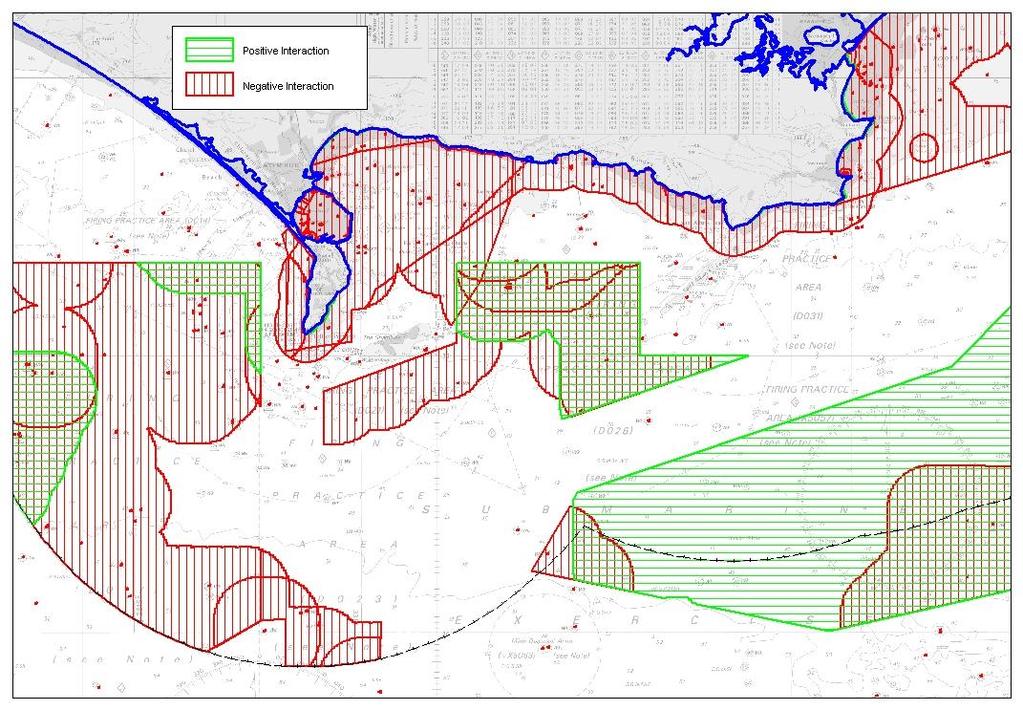
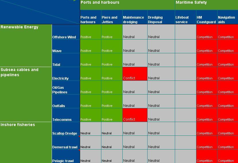
3 Offshore renewable capacity report Interactions matrix Policy Development & SEA Seabed Mapping Marine Spatial Plan Land & Seascape Assessment Policy Development & SEA Collection of Sectoral Spatial Information and data Existing Policies, Strategies & Agreements

4 Collation of spatial and temporal maritime sector data Exchanged and discussed data with Cefas, Crown Estate and Seazone/MMO adviser Gap Analysis conducted. tool All data held on Coastal Explorer Planning
5 Offshore renewable capacity report Interactions matrix Policy Development & SEA Seabed Mapping Marine Spatial Plan Land & Seascape Assessment Policy Development & SEA Collection of Sectoral Spatial Information and data Existing Policies, Strategies & Agreements

6 Existing Policies, Strategies & Agreements Policy Library: Over 200 policy documents international, European, national and local/regional policies, strategies and agreements. SEA process identified those that will have an influence on the MSP Policy workshop used planning scenarios to identify key documents Will be available through the planning tool

7 Coastal Explorer Planning GIS-based tool for planning professionals, developers, consultants, statutory/non-statutory consultees, academics. Over 270 data sets on current uses, environment and policy Provides planning guidance, policy summaries for terrestrial and marine environments Will also hold marine plan policy and maps once complete Dorset Explorer - CSCOPE

8 Plan Section Policy Number Hyperlink Summary Add to basket Portland Harbour Marine Spatial Plan Strategic Policy Policy 1 Portland Harbour Marine Spatial Plan Marine Access Policy 2 Portland Harbour Marine Spatial Plan Portland Harbour Marine Spatial Plan Energy Policy 4 Portland Harbour Marine Spatial Plan Environment Policy 5 Weymouth Portland Harbour Marine Spatial Plan Heritage Policy 6 Policy Portland Harbour 1 Marine Strategic and Portland Spatial Plan Policy Local Development Framework Leisure and Recreation Policy 7 Areas The aim Portland of Harbour Portland of Archaeological Marine Harbour Spatial Plan Authority s marine Potential spatial Nature Conservation plan policies is to manage and regulate Policy 8Portland Harbour effectively Where and efficiently Portland development Harbour in accordance Marine involves Spatial Plan with land Portland within Areas Harbour of Security Archaeological Authority s obligations Potential under defined the on Portland the Proposals Policy Harbour 9 Map, Revision the Borough Order 1997 Council and to Portland continue will Harbour require to Marine develop that Spatial the the impacts Plan physical of the assets proposals of Transport the on harbour the site's while archaeological protecting the importance natural resources Policy are 10examined for the benefit and evaluated of all Portland Harbour Marine Spatial Plan Water Resources Policy 11 Portland the results Harbour presented Authority prior will support to, as all part marine of, the plans, planning operations application and policies consistent with Portland Harbour Authority s Marine Portland Spatial Harbour Plan Marine Policies. Spatial Plan The 2012 Olympic and Para-Olympic Games Policy 12 Shoreline Management Plan Portland Harbour (North Breakw ater to Small Mouth) Policy Unit reference 5g18(b) Weymouth Portland Local Development Framew ork Areas of Archaeological Potential B5 Weymouth and Portland Local Development Framew ork SSSIs & Sensitive Marine Areas N15 Effective 15 th December Adopted December Weymouth and Portland Local Development Framew ork Local & Proposed Open Space C9 i
9 Policies International Legislation Level Sector All Jurisdiction All Display All MHW MLW 3 nms 6 nms 12 nms ~200 nms Anywhere At sea Harbour Limit Controlled waters SFC Limit UK water (Continental shelf limit) Nms Nautical Miles SFC Southern Fisheries Committee Legislation Level Sector Jurisdiction Policy name Hyperlink Summary Add to basket International Shipping Anywhere at sea United Nations Convention on the Law of the Sea (UNCLOS) International Shipping Anywhere at sea Safety of Life at Sea (SOLAS) Convention (1974) as amended United Nations Convention on the Law of the Sea (UNCLOS) International All Anywhere at sea Marine Pollution Convention/Protocol (1974) as amended International This All establishes a framework Anywhere at for sea the exercise World of summit various on sustainable sovereign development rights by coastal states, enabling exploitation of minerals International and living resources within territorial seas, extending up to 12nm from agreed national baselines. UNCLOS provides an Conservation Anywhere at sea Convention on biological diversity overarching framework for the marine environment. It sets national jurisdictions and establishes rights of navigation and the International legal Conservation regime of the high Anywhere sea. It at provides sea the Bonn legal convention basis on for the conservation protection of and migratory sustainable species of development wild animals of the marine environment and addresses environmental control, (1982) scientific research economic activities and the settlement of disputes. International UNCLOS Historicintroduced Anywhere the concept at seaof Exclusive UNESCO Economic Convention Zones Protection (EEZ). of UNCLOS Underwater covers Cultural virtually Heritage all uses of the sea including Environment navigation and over-flight, resource exploration (2001) and exploitation, conservation and pollution fishing and shipping. International Conservation Above MHW The Convention on Wetlands of International Importance 1971 (Ramsar Convention) as amended in 1982 and 1987
10 Offshore renewable capacity report Interactions matrix Policy Development & SEA Seabed Mapping Marine Spatial Plan Land & Seascape Assessment Policy Development & SEA Collection of Sectoral Spatial Information and data Existing Policies, Strategies & Agreements
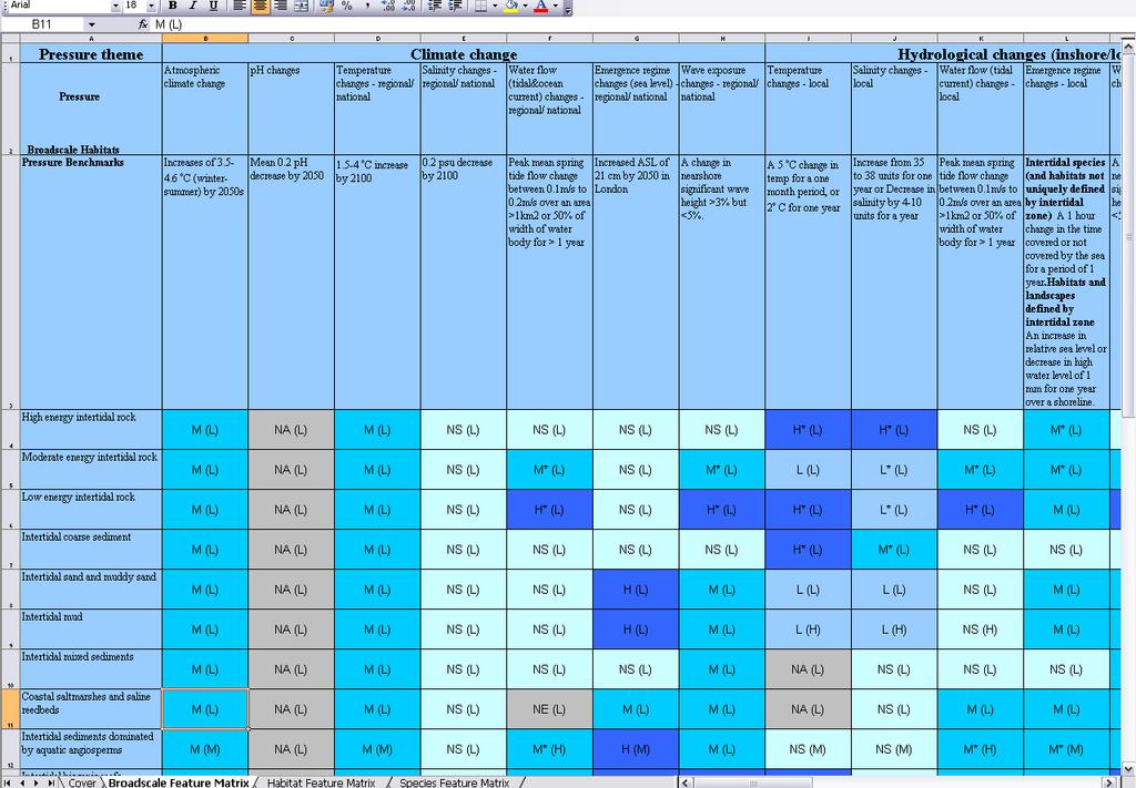
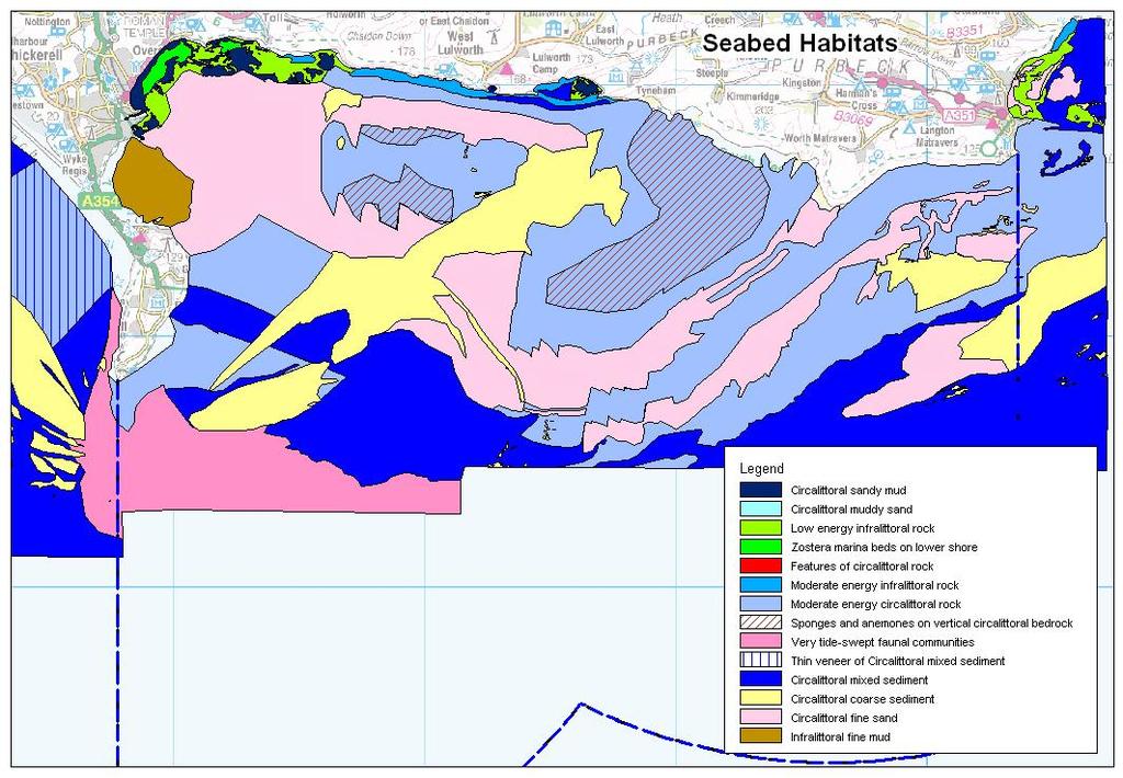
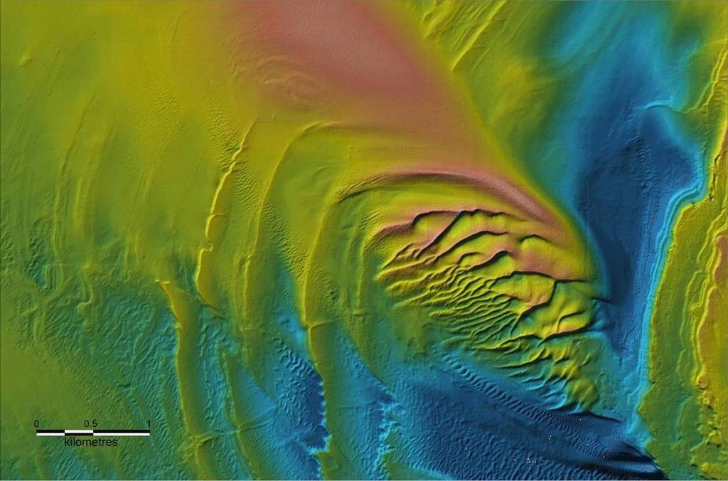
11 DORIS Seabed mapping MCA, CCO, DWT and Navy completed 800km 2 of multibeam survey to within 1m of chart datum Seamless MNCR habitat map (equivalent to EUNIS level 3) from the Southampton study. With the complexity of the seabed in this area, could not confidently produce seamless biotope map. Looking at ways to resolve this Biotopes defined in narrow zones around the drop-down video surveys. 36 biotope complexes / biotopes identified, Four new biotopes tentatively added Also have biological features of interest (e.g. maerl, mussel beds, pink sea fans, seagrass, sabellaria reefs) Will be using the Defra sensitivity matrix to map sensitive habitats, species and biotopes Also mapping ecosystem goods and services, using recent work by ABPmer/Bournemouth University for Natural England
12
13
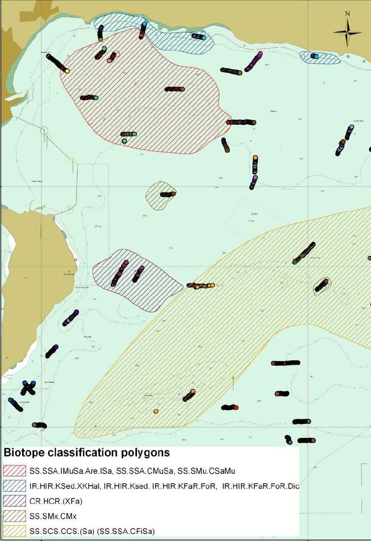
14 Biotopes

15 Biological features of interest (equate closely to MCZ FOCI)
16
17 Offshore renewable capacity report Interactions matrix Policy Development & SEA Seabed Mapping Marine Spatial Plan Land & Seascape Assessment Policy Development & SEA Collection of Sectoral Spatial Information and data Existing Policies, Strategies & Agreements

18 Offshore renewable capacity report Royal Haskoning report focused on: Current and emerging marine renewable energy technologies and their potential operating conditions Constraints mapping to identify potential areas for further offshore renewable energy development in Dorset waters Different approach to report for The Offshore Valuation Group; fewer hard constraints, no weighting. Development Considerations are discussed in the report for each potential development area identified.

19 Offshore renewable capacity report - wind

20 Offshore renewable capacity report - tidal

21 Offshore renewable capacity report ¼ scale wave
22 Offshore renewable capacity report Interactions matrix Policy Development & SEA Seabed Mapping Marine Spatial Plan Land & Seascape Assessment Policy Development & SEA Collection of Sectoral Spatial Information and data Existing Policies, Strategies & Agreements

23 There are five Seascape Character Areas within the MMA Man-Made Harbour Coastal Waters Active Coastal Waters Inshore Waters Deep Water Offshore Fishing N.B. Boundaries are transitional
24 Offshore renewable capacity report Interactions matrix Policy Development & SEA Seabed Mapping Marine Spatial Plan Land & Seascape Assessment Policy Development & SEA Collection of Sectoral Spatial Information and data Existing Policies, Strategies & Agreements
25
26
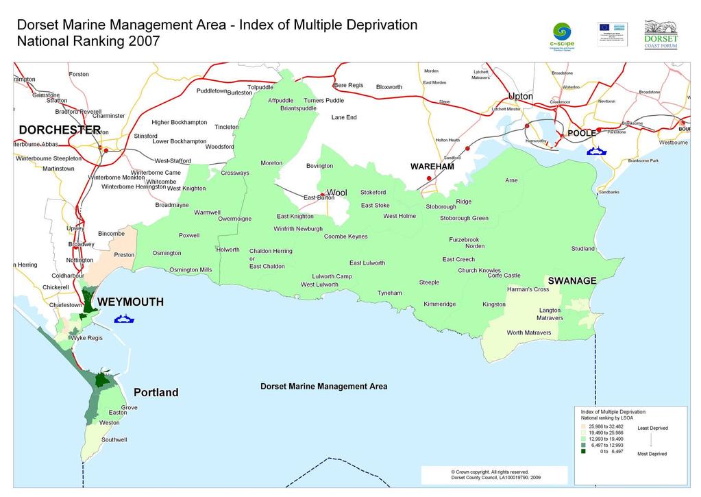
27 Socio-economic review

28 age group Demographics Population Pyramid, Dorset Marine Management Area and England & Wales av erage _ percentage of total population
29 Economic Impact Assessment Conducted as part of a much wider socio-economic report important to have context Used Econ-i software which analyses ripple effect of adding or taking away jobs in the marine sector Weighted by distribution of FTEs in sub-sectors (apportioned by relative strength) Multiplier is allocated, Three iterations take into account; Immediate suppliers Their suppliers effect through household spending of their employees

30 Forecasting Document Looking at past, current and future trends in marine sectors in Dorset including: Oil & Gas Offshore renewables & CCS Aggregates Fisheries & Aquaculture Tourism & Leisure Ports & Shipping
31 Offshore renewable capacity report Interactions matrix Policy Development & SEA Seabed Mapping Marine Spatial Plan Land & Seascape Assessment Policy Development & SEA Collection of Sectoral Spatial Information and data Existing Policies, Strategies & Agreements


32 Marine plan development Eight objectives derived from T&F Group wish-list and Defra s HLMOs Have explored various ways of expressing policy spatially Should we identify zones (e.g. Baltic Sea, GBRMR) and develop policy for those zones?... If so, how do you identify those zones? Marxan? Constraints mapping? Existing uses? Seascape Character? or do we develop a policy framework and express those policies spatially where possible? Opportunity areas? Presented various options to the T&F Group
33 Conservation; used existing boundaries for the dsac; aware this could change, and we will also need to include any MCZs in due course Renewables; used West of Wight zone, and areas from the Capacity Report. Used an 8nm cut-off point for acceptable development of southwest area. Commercial & Recreation used jurisdiction of Weymouth & Portland Harbours. Multi-use; everywhere else!

34 No area is exclusive, these are merely indicative of opportunities, which could take priority. Any other compatible use should be considered. Multi-use area would be open to all uses and activities (e.g. aquaculture, cables, extraction) provided they do not impact on listed sensitive areas (environmental, seascape and heritage) and go through due process.
 Criteria-based for specific development where appropriate Now developing that policy First draft May Marine Plan for")
35 Marine Plan Development T&F Group concluded policy should be: Hierarchical where necessary Expressed spatially where possible (including opportunity areas) Criteria-based for specific development where appropriate Now developing that policy First draft May Marine Plan for consultation August

36 Thank you


37 With special thanks to our funding partners and all our coastal stakeholders
Dorset Coastal Explorer Planning
 Dorset Coastal Explorer Planning Please read this information carefully. If you wish to proceed after reading this information you must signify your agreement to the following conditions of access by selecting
Natura 2000 in the marine environment: state of implementation and next steps
 Life on the blue planet: biodiversity research and the new European marine policies EPBRS European Platform on Biodiversity Research Strategy Porto, Portugal 7-9 November 2007 Natura 2000 in the marine
Outline National legislative & policy context Regional history with ESSIM ESSIM Evaluation Phase Government Integration via RCCOM Regional ICOM Framew
 What MSP Implementation could change in the Maritimes Region Tim Hall, Regional Manager Oceans and Coastal Management Division Ecosystem Management Branch Fisheries and Oceans Canada Maritimes Region BIO
National Perspectives - Portugal. Margarida Almodovar
 National Perspectives - Portugal Margarida Almodovar margarida.almodovar@mam.gov.pt from base line to the external limit of the continental shelf behind 200 miles and according to UNCLOS definitions Economic
xxv PART I THE DIVIDED OCEANS: INTERNATIONAL LAW GOVERNING JURISDICTIONAL ZONES 1
 Contents Preface page xv List of Figures xvii List of Tables xviii List of Abbreviations xix Table of Cases xxi Table of Treaties and Instruments xxv PART I THE DIVIDED OCEANS: INTERNATIONAL LAW GOVERNING
Specification & Content of Marine Reference Information
 Specification & Content of Marine Reference Information By Mike Osborne and James Rapaport SeaZone Solutions Limited CONTENTS 1. History of Marine Data 2. User Requirements 3. Geographic Content 4. SeaZone
MODELS AND TOOLS FOR GOVERNANCE OF
 Working Papers Collection No. 1/2015 MODELS AND TOOLS FOR GOVERNANCE OF THE ADRIATIC AND IONIAN SEAS www.unimc.it/maremap NATIONAL POLITICS AND EU POLITICS: THE MARITIME SPATIAL PLANNING AND INTEGRATED
Designing Networks of Marine Protected Areas in DFO s Three Atlantic Bioregions
 Designing Networks of Marine Protected Areas in DFO s Three Atlantic Bioregions Presentation for Indigenous Protected Areas Workshop Max Westhead, DFO and Adrian Gerhartz-Abraham, Dalhousie March 29, 2017
MARINE SPATIAL PLANNING & MARINE CADASTRE: CHALLENGES AND ISSUES
 MARINE SPATIAL PLANNING & MARINE CADASTRE: CHALLENGES AND ISSUES Roger Longhorn Secretary General, GSDI Association rlonghorn@gsdi.org Member, IHO Marine SDI Working Group ral@alum.mit.edu Member, UNESCO
Marine/Maritime Spatial Planning Andrej Abramić
 Marine/Maritime Spatial Planning Andrej Abramić EcoAqua SUMMER SCHOOL: Ecosystem approach to aquaculture 26-29th of October 2015 Research and Technology to enhance excellence in Aquaculture development
Maritime Spatial Planning Framework Directive Supported by INSPIRE
 Maritime Spatial Planning Framework Directive Supported by INSPIRE Andrej Abramić, Vanda Nunes de Lima, Paul Smits, Emanuele Bigagli, Chris Schubert European Commission Joint Research Centre Institute
Country Fiche Estonia
 Country Fiche Estonia Updated October 2017 1. General information Size of internal waters (to the baseline) and territorial sea (12-nm zone from the baseline) approximately 25 200 km 2. Exclusive economic
Country Fiche Estonia
 Country Fiche Estonia Deleted: October Updated May 2018 Deleted: 7 1. General information Size of internal waters (to the baseline) and territorial sea (12-nm zone from the baseline) approximately 25 200
1. Baltic SCOPE Towards coherence and cross-border solutions in Baltic Maritime Spatial Plans
 NSHC 32th Conference Explanatory Note Dublin, Ireland Item E.2 MSP 21-23 June 2016 Germany Cross border MSP for the EEZ, a case study from the Baltic Sea The Federal Maritime and Hydrographic Agency of
Country Fiche Latvia Updated October 2016
 Country Fiche Latvia Updated October 2016 1. General information Marine area under Latvian jurisdiction includes inland sea waters, Territorial sea (12 nautical miles from the baseline) and exclusive economic
Introduction to IMP: need and added value
 Introduction to IMP: need and added value Christophe Le Visage Consultant Stratégies Mer et Littoral 1 Summary IMP : Why? The case for integration 1 What is IMP? 2 Content, process IMP: Added Value 3 2
Maritime Spatial Planning in the Baltic Sea Region
 Maritime Spatial Planning in the Baltic Sea Region Talis Linkaits Head of VASAB Secretariat 20 May 2015 Helsinki A cooperation of ministers of the 11 Baltic Sea Region countries responsible for spatial
CX Debate Topic Analysis
 CX Debate Topic Analysis Larry McCarty lmac916@gmail.com or larry.mc@excite.com Resolved: The United States federal government should substantially increase its nonmilitary exploration and/or development
Offshore Energy and Maritime Spatial Planning in the German EEZ
 Offshore Energy and Maritime Spatial Planning in the German EEZ Bettina Käppeler, BSH Federal Maritime and Hydrographic Agency On Duty for Shipping and Seas German Exclusive Economic Zone EEZ not part
Marine Spatial Planning in Hellas; Recent Facts and Perspectives
 XXV FIG CONGRESS Engaging the Challenges, Enhancing the Relevance Kuala Lumpur, Malaysia 16 21 June 2014 Marine Spatial Planning in Hellas; Recent Facts and Perspectives Mrs. Chaiditsa BOLANOU Surveying
Country Fiche Lithuania
 Country Fiche Lithuania Updated June 2018 1. General information The Lithuanian maritime space is delimited by the Decree of the Government of the Republic of Lithuania of 6 December, 2004, No. 1597 and
Towards coherent maritime spatial planning in the Baltic Sea Region, transnational and project perspective Talis Linkaits Head of VASAB Secretariat
 3 June 2013 Riga PartiSEApate Workshop MSP as Tool for Underwater Cultural Heritage Management in the Baltic Sea Towards coherent maritime spatial planning in the Baltic Sea Region, transnational and project
Mediteranean sea issues in the view of ESPON ESaTDOR project and Marine Spatial Planning in Slovenia
 DIREKTORAT ZA PROSTOR, GRADITEV IN STANOVANJA Mediteranean sea issues in the view of ESPON ESaTDOR project and Marine Spatial Planning in Slovenia BlueMed meeting of stakeholders on a micro-regional level
Marine Spatial Planning as an important tool for implementing the MSFD
 Marine Spatial Planning as an important tool for implementing the MSFD Risto Kalliola Tallinn, Nov. 16 th 2012 DEPARTMENT OF GEOGRAPHY AND GEOLOGY University of Turku, Finland Ten principles to provide
POLISH LAW ON MSP. Andrzej Cieślak Maritime Office in Gdynia
 POLISH LAW ON MSP Andrzej Cieślak Maritime Office in Gdynia Preconditions Ownership/management of allsea areas (internal sea waters, territorial sea, EEZ): the State, and in its name the Minister responsible
Marine Spatial Planning (MSP): A practical approach to ecosystembased
: A practical approach to ecosystembased") Marine Spatial Planning (MSP): A practical approach to ecosystembased management Erik Olsen, Institute of Marine Research, Norway Fanny Douvere, International Oceanographic Commission Overview Why we need
Marine Spatial Planning (MSP): A practical approach to ecosystembased management Erik Olsen, Institute of Marine Research, Norway Fanny Douvere, International Oceanographic Commission Overview Why we need
NOAA Nautical Charts and Coastal and Marine Spatial Planning. Meredith Westington Chief Geographer NOAA/NOS/Office of Coast Survey
 NOAA Nautical Charts and Coastal and Marine Spatial Planning Meredith Westington Chief Geographer NOAA/NOS/Office of Coast Survey Ocean Policy Task Force What is CMSP? A comprehensive, adaptive, integrated,
Country Fiche Sweden Updated May 2018
 Country Fiche Sweden Updated May 2018 1. General information 2 the territorial sea (12-nm zone) 70,000 km2 the Exclusive Economic Zone 60,000 km2 the EEZ is limited to the central line between adjacent
Marine Spatial Planning: A Tool for Implementing Ecosystem-Based Management
 Marine Spatial Planning: A Tool for Implementing Ecosystem-Based Management Steven Murawski, Ph.D., Ecosystem Goal Team Lead National Oceanic and Atmospheric Administration NOAA November 16, 2009 1 To
Cross-border Maritime Spatial Plan for the Black sea - Romania and Bulgaria project
 Cross-border Maritime Spatial Plan for the Black sea - Romania and Bulgaria project in Romania and Bulgaria Plan Presentation A first step in the management of the marine areas of Romania and Bulgaria
Options in Capacity Building. Underpinning the Blue Economy. Slide 1/78. Derrick R. Peyton. 14 th MACHC Meeting. IIC Technologies. December 9-13, 2013
 Options in Capacity Building Underpinning the Blue Economy Derrick R. Peyton IIC Technologies 14 th MACHC Meeting December 9-13, 2013 Slide 1/78 Overview Blue Economy Defined Challenges (SDI, MSDI, Standards)
REPUBLIC OF THE MARSHALL ISLANDS MARITIME ZONES DECLARATION ACT 2016.
 Republic of the Marshall Islands Maritime Zones Declaration Act 2016. 33MIRCCh.1Index TITLE 33 - MARINE ZONES AND PROTECTION OF MAMMALS CHAPTER 1 - MARITIME ZONE DECLARATION s Republic of the Marshall
Marine Spatial Planning in the Baltic Sea Region
 Marine Spatial Planning in the Baltic Sea Region Towards coherence and cross-border solutions in Baltic Maritime Spatial Plans Coordinator & Project manager Dr Ingela Isaksson Swedish Agency for Marine
Linking Global and Regional Levels in the Management of Marine Areas Beyond National Jurisdiction
 Linking Global and Regional Levels in the Management of Marine Areas Beyond National Jurisdiction South Atlantic Region Session 4: «Experiences, Priorities and Opportunities in the South Atlantic and Indian
Pacific Islands Regional Maritime Boundaries Project
 Pacific Islands Regional Maritime Boundaries Project 31 st Star Conference, Nadi, FIJI 6-8 June 2016 Jens Kruger Head of Ocean & Coastal Geoscience Sector Andrick Lal Project Officer (Surveying) Emily
The Danish Maritime Spatial Data Infrastructure (MSDI) Geodata of the Sea
 Geodata of the Sea") MSDI/MSP The Danish Maritime Spatial Data Infrastructure (MSDI) Geodata of the Sea Components of an infrastructure: DATA - metadata, datasets FUNCTIONALITY - spatial data services, web services and other
MSDI/MSP The Danish Maritime Spatial Data Infrastructure (MSDI) Geodata of the Sea Components of an infrastructure: DATA - metadata, datasets FUNCTIONALITY - spatial data services, web services and other
HELSINKI COMMISSION Baltic Marine Environment Protection Commission
 HELSINKI COMMISSION Baltic Marine Environment Protection Commission HELCOM RECOMMENDATION 24/10 Adopted 25 June 2003, having regard to Article 20, Paragraph 1 b) of the 1992 Helsinki Convention IMPLEMENTATION
Marine Spatial Planning Leslie-Ann McGee Battelle Memorial Institute
 Marine Spatial Planning Leslie-Ann McGee Battelle Memorial Institute Rev061708 1 Marine Spatial Planning What is it? Why is it different? Where is it currently being employed? What is happening in the
BURGAS CASE STUDY: LAND-SEA INTERACTIONS. Dr. Margarita Stancheva
 BURGAS CASE STUDY: LAND-SEA INTERACTIONS Dr. Margarita Stancheva Name of presentation NEED FOR COHERENCE BETWEEN LAND AND SEA ACTIVITIES Name presenter Burgas is the fourth largest city in Bulgaria and
TOWARDS CLIMATE-RESILIENT COASTAL MANAGEMENT: OPPORTUNITIES FOR IMPROVED ICZM IN BELIZE
 TOWARDS CLIMATE-RESILIENT COASTAL MANAGEMENT: OPPORTUNITIES FOR IMPROVED ICZM IN BELIZE CHANTALLE SAMUELS Coastal Zone Management Authority and Institute The Caribbean Community Climate Change Centre VULNERABILITY
Spatial Planning in Canada s Maritimes Region. Maritimes Region
 Spatial Planning in Canada s Maritimes Region Glen Herbert, Scott Coffen-Smout Smout,, and Tanya Koropatnick Oceans and Coastal Management Division Ecosystem Management Branch Fisheries and Oceans Canada
Croatian physical planning system and strategic approach to MSP
 W 1/7 Past two years all over the Europe: case studies 2 Croatian physical planning system and strategic approach to MSP Vesna Marohnić Kuzmanović Head of Department Croatian Institute for Spatial Development
Aquaculture Spatial Planning: The case of Greece
 Aquaculture Spatial Planning: The case of Greece Nikos Anagnopoulos Panhellenic Association for Small-Medium sized Aquaculture Enterprises Panhellenic Association for Small-Medium sized Aquaculture Enterprises
Use of Elevation Data in NOAA Coastal Mapping Shoreline Products. Coastal GeoTools April 1, 2015
 Use of Elevation Data in NOAA Coastal Mapping Shoreline Products Coastal GeoTools April 1, 2015 - NOAA s Coastal Mapping Program & CUSP - Shoreline Uses, Delineation Issues, Definitions - Current Extraction
World Oceans Day 2010 Our oceans: opportunities and challenges
 World Oceans Day 2010 Our oceans: opportunities and challenges Roundtable discussion on the United Nations Convention on the Law of the Sea fifteen years after its entry into force HOW EFFECTIVELY IS UNCLOS
Maritime Spatial Planning: Transboundary Cooperation in the Celtic Seas Looking Ahead
 Maritime Spatial Planning: Transboundary Cooperation in the Celtic Seas Looking Ahead Looking ahead MSP in the context of the European Maritime and Fisheries Fund (EMFF) and beyond SIMCelt Final Conference
Using Data and Evidence to Inform Marine Spatial Planning
 Coastwatch Workshop and Launch of 30 years of Coastwatch Data Using Data and Evidence to Inform Marine Spatial Planning Stephen Hull Overview What is MSP? What is MSP trying to achieve? Ireland s MSP process
Seabed knowledge In support of UN SDGs
 Seabed knowledge In support of UN SDGs Evert Flier Fiskerifaglig forum 2. november 2017 Hydrography & small scale fishing Hydrography in Transition Serving the Maritime Community Hydrography in Transition
MSP Process drawings and descriptions
 MSP Process drawings and descriptions 12 December 2016 2 Table of Contents 1. Belgium... 3 2. The Netherlands... 5 3. Germany... 7 4. Denmark... 9 5. Scotland... 11 6. Sweden... 13 7. Norway... 15 1. Belgium
IMA s ROLE IN COASTAL AND OCEAN GOVERNANCE IN TRINIDAD AND TOBAGO
 IMA s ROLE IN COASTAL AND OCEAN GOVERNANCE IN TRINIDAD AND TOBAGO Presented by Rahanna Juman, Deputy Director (Ag.) About the Institute of Marine Affairs Institute of Marine Affairs (IMA) was established,
WELCOME & INTRODUCTION
 MPA Management Capacity Building Training Module 1: WELCOME & INTRODUCTION Participants Distinguished Guests Welcome Site Overviews of MPAs represented Overview of Training Program What are Today s Objectives?
Summary Report. 7-8 November, 2013 Sports Complex of the Central Sports Club of the Army, Severnyi mol 7 Baltiysk, Kaliningrad Oblast Region, Russia
 RU LT Transnational stakeholders meeting on the concept for maritime spatial planning in the Lithuanian Sea and its potential impacts on sea use in Russia 7-8 November, 2013 Sports Complex of the Central
PartiSEApate Conference
 Baltic Maritime Spatial Planning Forum PartiSEApate Conference C r e a t i n g c o m m o n u n d e r s t a n d i n g B a l t i c M a r i t i m e S p a t i a l P l a n n i n g F o r u m B a l t i c M a
EUSAIR on sea topics from Slovenian perspective
 MINISTRY OF FOREIGN AFFAIRS REPUBLIC OF SLOVENIA EUSAIR on sea topics from Slovenian perspective Mag. Andreja Jerina National Coordinator 4 EU MRS: 270 millions of population 19 MS 12 non MS Sea basin
PACIFIC ISLANDS REGIONAL OCEAN POLICY. A healthy Ocean that sustains the livelihoods and aspirations of Pacific Island communities.
 PACIFIC ISLANDS REGIONAL OCEAN POLICY VISION A healthy Ocean that sustains the livelihoods and aspirations of Pacific Island communities. THIS IS OUR OCEAN 1. The care of the ocean is the responsibility
MARINE SPATIAL PLANNING
 MARINE SPATIAL PLANNING Washington Uses Spatial Planning to Honor its Pacific Coast and Offshore Waters Past, Present and Future The Washington State Pacific Coast and offshore waters are diverse in both
A TOOLKIT FOR MARINE SPATIAL PLANNING Version: 17 July, 2009
 A TOOLKIT FOR MARINE SPATIAL PLANNING Version: 17 July, 2009 NEED FOR MARINE SPATIAL PLANNING The health of marine ecosystems is declining, and use conflicts in the marine environment are increasing, in
Evaluation of Spatial Planning as a Tool for Integrated Marine Management Status, Obstacles and Research Gaps
 Evaluation of Spatial Planning as a Tool for Integrated Marine Management Status, Obstacles and Research Gaps Baltic MSP Forum Riga 17.-18. June 2014 A. Morf & A. Grimvall: Swedish Institute for the Marine
Necessary common minimum requirements for Maritime Spatial Planning (MSP) in the Baltic Sea
 in the Baltic Sea") www.planbothnia.org Co-financed under European Integrated Maritime Policy Necessary common minimum requirements for Maritime Spatial Planning (MSP) in the Baltic Sea Contribution to the PLAN BOTHNIA work
www.planbothnia.org Co-financed under European Integrated Maritime Policy Necessary common minimum requirements for Maritime Spatial Planning (MSP) in the Baltic Sea Contribution to the PLAN BOTHNIA work
MARITIME PLANNING IN PORTUGAL
 MARITIME PLANNING IN PORTUGAL Marta Chantal Ribeiro 2 May 2007 In Portugal there is currently no strategic planning system in force for the maritime area as a whole The maritime area under Portuguese jurisdiction
Country reports. Israel did not establish an Exclusive Economic Zone. Consequently, its jurisdiction is restricted to the Israeli territorial waters.
 Country reports I. ISRAEL Disclaimer This document has not been adopted by the European Commission and should therefore not be relied upon as a statement of the European Commission. The purpose of this
Maritime Spatial Planning Country Information. United Kingdom.
 Maritime Spatial Planning Country Information United Kingdom The European MSP Platform is financed by the EU Commission under the EMFF Workprogrammes 2014 and 2015. The European MSP Platform is a result
Ocean Governance and the Japanese Basic Act on Ocean Policy
 Ocean Governance and the Japanese Basic Act on Ocean Policy Hiroshi Terashima Executive Director Ocean Policy Research Foundation 14 April 2009 The United Nations Nippon Foundation Fellowship Programme
Rising from the Depths Utilising Marine Cultural Heritage in East Africa to help develop sustainable social, economic and cultural benefits
 KENYA MEETING, 23 rd FEBRUARY 2018 1 Rising from the Depths Utilising Marine Cultural Heritage in East Africa to help develop sustainable social, economic and cultural benefits 1. Introduction The Rising
Why do we need a global framework for MPAs in ABNJ? Kristina M. Gjerde IUCN High Seas Policy Advisor
 Why do we need a global framework for MPAs in ABNJ? Kristina M. Gjerde IUCN High Seas Policy Advisor kgjerde@eip.com.pl 40% ocean heavily affected by humans (c) Halpern et al. 2008. Scientists found that
BURGAS CASE STUDY: LAND-SEA INTERACTIONS
 BURGAS CASE STUDY: LAND-SEA INTERACTIONS Dr. Margarita Stancheva IO-BAS, Bulgaria Name of presentation CROSS BORDER MARITIME SPATIAL PLANNING IN THE BLACK SEA ROMANIA AND BULGARIA (MARSPLAN BS) Project
The Socio Economic Development of the Marine Sector in the Atlantic Area. Stephen Hynes
 The Socio Economic Development of the Marine Sector in the Atlantic Area Stephen Hynes Overview SEMRU and its role in Marine Socioeconomic analysis Defining Ocean and Coastal Economies in the Atlantic
SPLAN-Natura Towards an integrated spatial planning approach for Natura th January, 2017 Brussels. Commissioned by DG Environment
 SPLAN-Natura 2000 Towards an integrated spatial planning approach for Natura 2000 Commissioned by DG Environment 17 th January, 2017 Brussels V. Simeonova (Ph.D.) Drivers towards integrating Biodiversity
Law of the Sea Symposium, February, 2016, TOKYO International Law for the Resources of the Sea
 Law of the Sea Symposium, 16-17 February, 2016, TOKYO International Law for the Resources of the Sea Segment 2 Governance of Resources of the Continental Shelf (including extended continental shelf) Introduction
Mapping ecosystem services provided by benthic habitats in the European Atlantic Ocean
 Mapping and Assessment Ecosystem Services and Links to Good Environmental Status Mapping ecosystem services provided by benthic habitats in the European Atlantic Ocean Ibon Galparsoro, Angel Borja and
European Commission. Legal aspects of maritime spatial planning. Summary report
 European Commission SOCIO-ECONOMIC STUDIES IN THE FIELD OF THE INTEGRATED MARITIME POLICY FOR THE EUROPEAN UNION Legal aspects of maritime spatial planning Summary report Socio-economic studies in the
EASTERN SCOTIAN SHELF INTEGRATED OCEAN MANAGEMENT PLAN
 Government of Canada Gouvernement du Canada EASTERN SCOTIAN SHELF INTEGRATED OCEAN MANAGEMENT PLAN SUMMARY Photo Credits: Bedford Institute of Oceanography Published by: Oceans and Habitat Branch Fisheries
MESMA: An integrated tool box to support an ecosystem based spatial management of marine areas
 MESMA: An integrated tool box to support an ecosystem based spatial management of marine areas Stelzenmüller, V., Stamford, T., Vassilopoulou, V., Kastanevakis, S., Vincx, M, Vanaverbeke, J., Rabaut, M.,
Marine Spatial Planning Experience from Mecklenburg-Vorpommern (Germany) By Susan Toben
 By Susan Toben") Marine Spatial Planning Experience from Mecklenburg-Vorpommern (Germany) By Susan Toben Ministry of Transport, Building and Regional Development Mecklenburg Vorpommern PlanCoast Lead Partner Administrative
Marine Spatial Planning Experience from Mecklenburg-Vorpommern (Germany) By Susan Toben Ministry of Transport, Building and Regional Development Mecklenburg Vorpommern PlanCoast Lead Partner Administrative
Economic and Social Council 10 July 2013
 ADVANCE UNEDITED VERSION UNITED NATIONS E/C.20/2013/10/Add.1 Economic and Social Council 10 July 2013 Committee of Experts on Global Geospatial Information Management Third session Cambridge, United Kingdom
DFO Maritimes Region Update. Gulf of Maine Council - Coastal and Marine Spatial Planning (CMSP) Committee Web-Ex May 16, 2017
 Committee Web-Ex May 16, 2017") DFO Maritimes Region Update Gulf of Maine Council - Coastal and Marine Spatial Planning (CMSP) Committee Web-Ex May 16, 2017 1 National Oceans Priorities Marine Conservation Targets Oceans Protection Plan
DFO Maritimes Region Update Gulf of Maine Council - Coastal and Marine Spatial Planning (CMSP) Committee Web-Ex May 16, 2017 1 National Oceans Priorities Marine Conservation Targets Oceans Protection Plan
National Land Use Policy and National Integrated Planning Framework for Land Resource Development
 Title National Land Use Policy and National Integrated Planning Framework for Land Resource Development Duration: 32 Weeks Objective: Adoption of appropriate land use planning approaches to: Maintain the
Applying GIS to Coastal Management in Cork Harbour: the Corepoint experience
 Applying GIS to Coastal Management in Cork Harbour: the Corepoint experience Kathrin Köpke University College Cork, Ireland Thematic Conference: THE WATERFRONT MANAGEMENT AND GI (IT), 14 th -18 th November
DRAFT PROGRAM Registration of participants, welcome coffee, exhibition tour
 DRAFT PROGRAM 20 Feb 2018 09.00-10.00 Registration of participants, welcome coffee, exhibition tour 10.00 12.00 ROUND TABLE: INTERNATIONAL COOPERATION IN THE ARCTIC PROJECTS: CHALLENGES AND OPPORTUNITIES
Iceland and the Arctic: The Politics of Territoriality. Valur Ingimundaron Professor of Contemporary History, University of Iceland
 Iceland and the Arctic: The Politics of Territoriality Valur Ingimundaron Professor of Contemporary History, University of Iceland Drivers of Icelandic Arctic Policies Geostrategic Position Economic Interests
Capacity Development and ABNJ
 ABNJ Regional Leaders Program First Session Capacity Development and ABNJ Regional and National Perspectives Examples from Africa January 21, 2015 Conference Room 7, United Nations HQ New York, USA Outline
Tackling MSP integration challenges in the BSR
 Towards sustainable governance of Baltic marine space 2015 2018 BALTSPACE Towards sustainable governance of Baltic marine space Tackling MSP integration challenges in the BSR Michael Gilek, Södertörn University,
Introduction to EMODnet
 Introduction to EMODnet Antonio Novellino Torino, 14-15 Ottobre 2015 What is EMODnet? Initiated by the European Commission in response to the EU Future Maritime Policy and Blue Growth, launched in June
A trans-atlantic assessment and deep-water ecosystem-based spatial management plan for Europe
 A trans-atlantic assessment and deep-water ecosystem-based spatial management plan for Europe This project has received funding from the European Union s Horizon 2020 research and innovation programme
Additional information (material for interactions and analysis chapter) to document 3/1, the PLAN BOTHNIA MSP Assessment
 to document 3/1, the PLAN BOTHNIA MSP Assessment") Co-Financed Under European Integrated Maritime Policy PLAN BOTHNIA MSP 2/2011 MSP Assessment Add 1 PLAN BOTHNIA MSP 2 Uppsala, Sweden June 14-15 2011 Agenda Item 3 PLAN BOTHNIA MSP Assessment Document
Co-Financed Under European Integrated Maritime Policy PLAN BOTHNIA MSP 2/2011 MSP Assessment Add 1 PLAN BOTHNIA MSP 2 Uppsala, Sweden June 14-15 2011 Agenda Item 3 PLAN BOTHNIA MSP Assessment Document
Identifying Sensitive Marine Areas: A tour of the legal and scientific criteria
 Identifying Sensitive Marine Areas: A tour of the legal and scientific criteria CIL High Seas Governance: Gaps and Challenges Panel 1 on Sensitive Marine Areas 24-25 April 2017, Singapore Youna Lyons,
Identification of maritime spatial planning best practices in the Baltic Sea Region and other EU maritime regions
 Identification of maritime spatial planning best practices in the Baltic Sea Region and other EU maritime regions PLAN BOTHNIA Baltic Sea Region Stakeholder Meeting Jacek Zaucha, Magdalena Matczak Two
International Guidelines for Ecosystem-based, Marine Spatial Management
 International Guidelines for Ecosystem-based, Marine Spatial Management Charles Ehler and Fanny Douvere, Consultants Intergovernmental Oceanographic Commission and Man and the Biosphere Programme UNESCO
Zoning for the Seychelles Marine Spatial Planning Intiative: process, types, and tools
 Zoning for the Seychelles Marine Spatial Planning Intiative: process, types, and tools To: MSP Technical Working Group From: MSP Technical Team Date: 4 July 2014 Table of Contents 1. Introduction and context...
DELIVERING ECOSYSTEM- BASED MARINE SPATIAL PLANNING IN PRACTICE
 DELIVERING ECOSYSTEM- BASED MARINE SPATIAL PLANNING IN PRACTICE A first assessment for the UK and Ireland January 08 GLOBAL WARMING IMAGES / WWF ABOUT WWF WWF is the world s leading independent conservation
Mapping of marine habitats in shallow coastal areas in Denmark
 6 th Workshop Seabed Acoustics, Rostock, November 14/15, 2013 P11-1 Mapping of marine habitats in shallow coastal areas in Denmark Dr. Zyad Al-Hamdani Geological Survey of Denmark and Greenland - GEUS
Maritime Spatial Planning in Germany and Mecklenburg-Vorpommern
 Integrated Sea Use Planning Followings the Ecosystem Approach 2.10.08 Maritime Spatial Planning in Germany and Mecklenburg-Vorpommern by Helmuth von Nicolai Spatial Planning Department Ministry of Transport,
This document has been verified by the responsible MSP authority (or representative) of Lithuania on
 of Lithuania on") Contact MSP in general Ms. Algimantė Treinienė Head of Spatial Planning Urban Development and Architecture Division Construction and Territorial Planning Department Ministry of Environment A. Jakšto 4
Contact MSP in general Ms. Algimantė Treinienė Head of Spatial Planning Urban Development and Architecture Division Construction and Territorial Planning Department Ministry of Environment A. Jakšto 4
Country Fiche Latvia.
 Country Fiche Latvia 1. General information Marine waters under Latvian jurisdiction include inland sea waters, territorial sea (12 nautical miles from the baseline) and exclusive economic zone (EEZ) waters.
The Spatial Offshore Grid Plan for the German Exclusive Economic Zone
 11 2 The Spatial Offshore Grid Plan for the German Exclusive Economic Zone Annika Koch 2.1 Legal mandate 12 2.2 Accompanying Strategic Environmental Assessment 12 2.3 Results of the Environmental Report
THE ROLE OF SPATIAL PLANNING IN INTEGRATED COASTAL ZONE MANAGEMENT RECOMMENDATIONS FROM THE INTERREG III B BALTCOAST PROJECT
 THE ROLE OF SPATIAL PLANNING IN INTEGRATED COASTAL ZONE MANAGEMENT RECOMMENDATIONS FROM THE INTERREG III B BALTCOAST PROJECT DISCUSSION PAPER FOR THE TRANSNATIONAL WORKING GROUP DECEMBER 2004 CONTENT 1.
THE SEVILLE STRATEGY ON BIOSPHERE RESERVES
 THE SEVILLE STRATEGY ON BIOSPHERE RESERVES 1 VISION FOR BIOSPHERE RESERVES IN THE 21 ST CENTURY The international Seville Conference on Biosphere Reserves, organised by UNESCO, adopted a two-pronged approach,
Arctic ecosystem services: TEEB Arctic Scoping study. Alexander Shestakov WWF Global Arctic Programme 3 December Arctic Biodiversity Congress
 Arctic ecosystem services: TEEB Arctic Scoping study Alexander Shestakov WWF Global Arctic Programme 3 December 20143 Arctic Biodiversity Congress Content 1. Project design 2. Approach 3. Challenges and
Implementation of the Political Declaration on energy cooperation between the North Seas Countries. Support Group 1 on Maritime Spatial Planning
 Implementation of the Political Declaration on energy cooperation between the North Seas Countries Support Group 1 on Maritime Spatial Planning Work Programme 1. Work area as outlined in Annex I to the
Management Planning & Implementation of Communication Measures for Terrestrial Natura 2000 Sites in the Maltese Islands Epsilon-Adi Consortium
 Management Planning & Implementation of Communication Measures for Terrestrial Natura 2000 Sites in the Maltese Islands Epsilon-Adi Consortium Briefing Meetings, February 2013 CT3101/2011, MEPA, Malta