QUATERNARY SC IENCES
|
|
|
- Candace Farmer
- 5 years ago
- Views:
Transcription
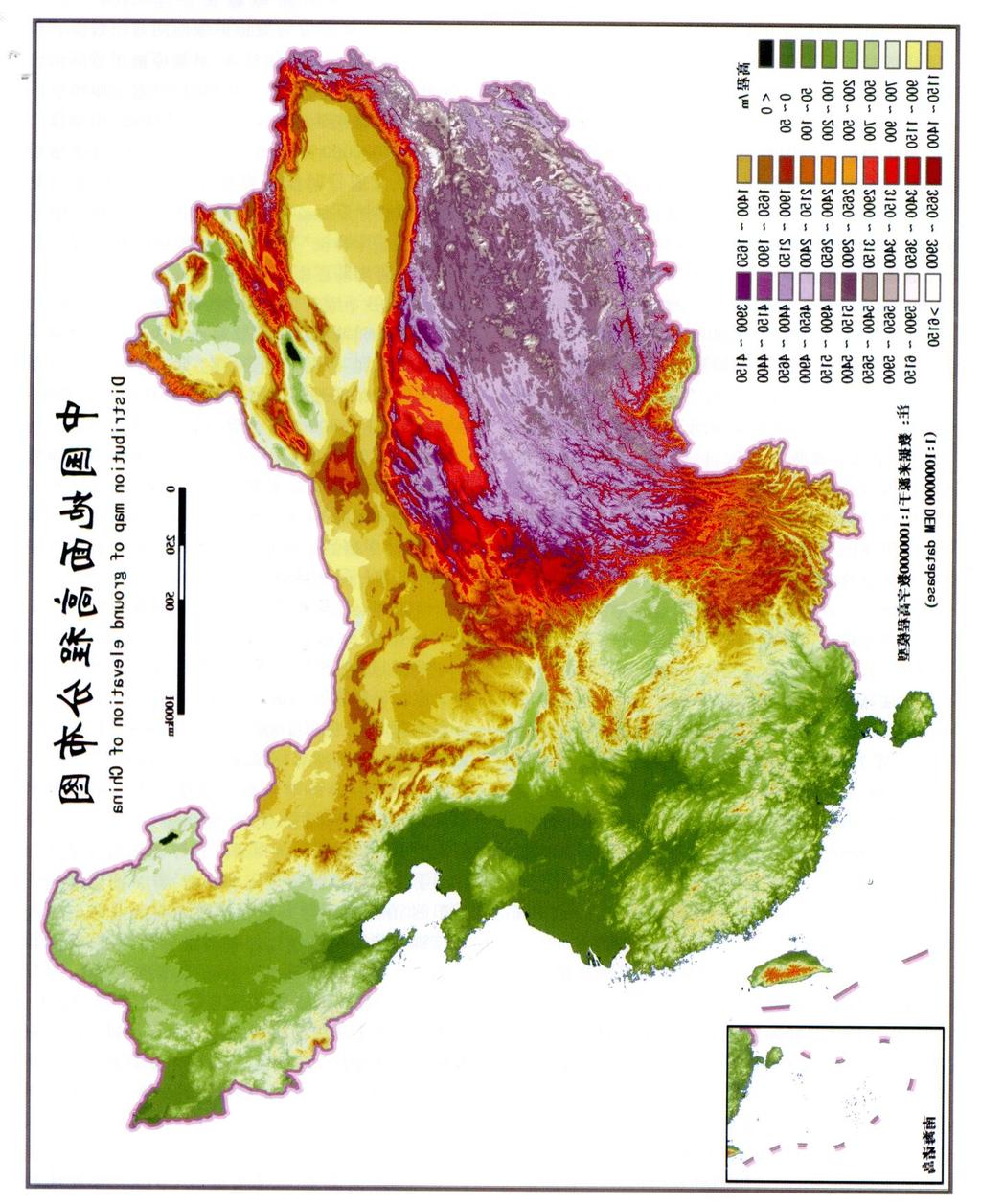
1 QUATERNARYSC IENCES Vol. 28, No. 4 July, (2008) (, ;,, ),, 100,,,,,, ( < 200m) (200500m) ( m ) ( m)( > 2500m)7,, (DTM ), 1000m, 2000m, 4000m 6000m ( < 1000m ) ( m ) ( m) ( m)( > 6000m ) 7 5, 28 P A,, 8848m 154m,,,,,, [ 1 ],, 1894, A. Penck ( ) [ 2 ] 6,100,, ),,,,, ,,,( ) (?) [ 3, 4 ], ( )20 50 : 68 E2mail: liby@ igsnrr1ac1cn 3 (: 2005CB42001) , )(). ( ), 1981, (4) : 7095
2 ,, ( ) () (1) ,,,,(1956) [ 5 ] ( ) [ 3, 6 ] [ 5 ],(?),, ( < 200m, 50m ) (> 500m ) ( > 1000m,> 500m ) ( < 500m, 50500m ) ( m, 500m ) ( > 3000m),,,,,, ( > 2500m ) ;, 1959 [ 3 ],,, 500m, 1000m, 3000m 5000m, 100m, 500m1000m 4 [ 3 ],,,,, (2) , , , [ 7 ],,, [ 8 ] ; 5 1), [ 9 ], ( ), :,, [ 10 ] ; 2500m, ( > 1000m) ( > 5800m ) ( m ) ( m ) ( < 1000m) ; 22 [ 11 ] ( ) ( 1987) [ 12 ],1959, 1959,, > 2500m, 18(1) [ 3, 12 ] ),.. :
3 4 : [ 12 ] Table 1Basic geomorphology of China < 2030m < 100m m m m m > 2500m < 1000m m m > 5000m, [ 1 ], (2) 20 50,,,, ([ 1 ], p51) Table 2Geomorphologic type system of Europe ( ) ( from Ref. [ 1 ], p51) /m 3 /m 2. a. b a b. > > (a. < 1300 ) b. > ( ) > 2000 > km 2 (m) () [ 13 ] (020m ) (2075m ) (75 200m) ( m ) ( > 600m )5, ( ) ( 2) (020m ) ( < 500m; > 500m, 20150m ) ( m > 150m ) ( m) ( m ) ( m) ( > 5500m)7 2,,,,,,,,, ;,,,,,,, [ 10 ],,,,,,,,,,,,,,,,, ( ),
4 ,,,() () ( ) ;, (: ), ( ),,,,, 7, [ 12, 14 ],,,50m500m, 3 [ 5 ], [ 13 ] [ 15 ],21km 2,20m, 75m, 200m 600m 5,DTM, ( ),,, 21km 2, 21km 2, ( ) [ 12 ], () ( 500km 2 ) ( 5km ),,,, m,, m, m, m,,,, 1000m (), 1000m, 500m 200m 3, m, 2500m ( ) 500m ( < 200m ), - 200m,,,, 5 : ( < 200m ) ( m) ( m ) ( m)( > 2500m ),(), ( ),5 [ 11, 12 ] 4 [ 13 ] [ 15 ] DTM
5 4 : 539, 6, < 500m m, m, m, > 5500mDTM,,, ( ) [ 12 ],1959 [ 3 ], 1000m, 3500m5000m, ( 1) [ 3 ],(5000m) (3500m ), (1000m ) 1000m,,, ;, [ 3 ] 50, [ 16 ] 6200m ( ), 2800m ( ),3400m, [ 1719 ] 5300m ()1500m ( ),3800m [ 20 ] 4400 ( ) 4600m ( ), 2000m [ 16, 21 ],, , (DTM ) 200m250m (P540 ), :, m m, 6000m, ; m m 200m, 1000m, 1000m, 2000m, ( ) m, 1000m ; m, 4000m, ( ) [ 12 ],3500m,,> 5000m -, 3500m > 5000m,,, ( ), 1000m,,,, 3500m 4000m;,5500m 6000m; ( m ), m,
6
7 4 : Table 3Basic geomorphologic type of China (1) < 1000m (2) m (3) m (4) m (5) > 6000m (< 200m) (200500m) ( m) ( m) ( > 2500m) () : ( < 1000m ) ( m ) ( m ) ( m ) ( > 6000m) [ 14 ],,, 200m,, m,,,, 5, 7 5, 28(3) ( ), [ 14 ] ( ),, [ 3 ], [ 8 ],,20 50,,, [ 12 ], ( ) (R e fe rence s) 1,.. :, Su Shiyu, L i Juzhang. Geomorphological Mapping. Beijing: Surveying and Mapp ing Press, Penck A. Morphologie der Erdoberflaeche ( 2 Bde ). Stuttgart: Engelhorn, / ( ). :, Shen Yuchang ed. Geomorphological Compartmentalization of China ( the first draft). Beijing: Science Press, ,.. :, Li Siguang, Zhang Wenyou editor and translation. Shanghai: Zhengfeng Press, Geology of China. 5,,.. :.. :, Zhou Tingru, Shi Yafeng, Chen Shupeng. Topographic Compart2 mentalization D raft of China. In: Editorial Board of Chinese Geography Record ed. China. Beijing: Science Press, Physical Compartmentalization D raft of 6.., 1958, 1 (1) : 3341 Shen Yuchang. The discussion on geomorphological types and compartmental p roblems of China. Quaternary S inica, 1958, 1 ( 1) : ,.
8 :, The Editorial Comm ission of1 1, 000, 000 GeomorphologicalMap of China, Iustitute of Geography, Chinese Academy of Sciences eds. Geomorphological Mapping Research. Beijing: Surveying and Mapp ing Press, : 1 100,.. :, Chai Zongxin. The suggestion of basic geomorphological types according to relative height. In: The Editorial Comm ission of Geomorphological Map of China, Iustitute of Geography, Chinese Academy of Sciences eds. Geomorphological Mapping Research. Beijing: Surveying and Mapping Press, , 1982, 37 (1) : 1726 L i Juzhang. A prelim itary study on the quantitative index of basic types of geomorophologic form in China. 1982, 37 (1) : 1726 Acta Geographica S inica, 10, : 1 100,.. :, L i B ingyuan, L i Juzhang. Legend system of 1 1, 000, 000 geomorphological map and the discussion of geomorphological types. In: The Editorial Comm ission of1 1, 000, 000 Geomorphological Map of China, Iustitute of Geography, Chinese Academy of Sciences eds. Geomorphological Mapp ing Research. Beijing: Surveying and Mapp ing Press, ,.. :, L i B ingyuan, Zheng Yihong eds. Geomorphological Map of Q inghai Province and Instruction. Beijing: Surveying and Mapping Press, ( ). :, Institute of Geography, Chinese Academy of Sciences ed Geomorphological Mapping Specification ( trial ). Beijing: Science Press, :, Chen Zhim ing ed. Exp lanations of Geomorphological Map of China and Its Adjacent A reas ( ) : An Outline of Chinaπs Geomorphology. Beijing: Sinomap s Press, , :, 1994 L i B ingyuan, L i Juzhang eds. of China. Beijing: Science Press, Geomorphological Map 15.., 1989, 9 (1) : 3138 L iu Zhendong. Study on statistic unit of relief amp litude in China. Tropical Geography, 1989, 9 (1) : ,,.., 2003, 58 (2) : Zhang Baiping, Zhou Chenghu, Cheng Shupeng. The geo2info2 spectrum of montane altitudinal belts in China. S inica, 2003, 58 (2) : A cta Geographica 17.. :, Lanzhou Institute of Glaciology and Geocryology, Chinese Academy of Sciences ed. An Introduction to the Glaciers in China. Beijing: Science Press, (V ) ( ). :, Lanzhou Institute of Glaciology and Geocryology, Chinese Academy of Sciences ed. Glacier Inventory of China ( V ) : Karakorum Mountains(D rainage Basin of the Yarant R iver). Press, Beijing: Science 19,.. :, Shi Yafeng, Cold and A rid Regions Environmental and Engineering Research Institute, Chinese Academy of Sciences eds. Concise Glacier Inventory of China. Shanghai: Shanghai Science Popularization Press, ,,.. :, Zhou Youwu, Cheng Guodong, Guo Dongxin et al. eds. in China. Beijing: Science Press, Geocryology 21,.. :, Sun Honglie, Zheng Du eds. Formation, Evolution and Development of Q inghai2xizang( Tibetan) Plateau. Beijing: Science Press, BAS IC TERRESTR IAL GEOMO RPHOLO G ICAL TY PES IN CH INA AND THE IR C IRCUM SCR IPT IO NS L i B ingyuan Pan Baotian Han J iafu ( Institute of Geographic Sciences and N atural R esources Research, Chinese Academ y of Sciences, B eijing ; Key Laboratory of W estern Chinaπs Environm ent System (M inistry of Education) College of Earth and Environm ent Sciences, and Departm ent of Geography, Lanzhou University, Lanzhou ) Abstract In the past one hundred years, the classification of landform s has been discussed considerably. Som e authors
9 4 : 543 called the term s like p lain, p latform, hill and as basic morphologies but we think they are landform types, because these term s are defined not only by their morphological characteristics, but also by their form ations. system ically analyzing and evaluating the existing fundam ental geomorphological classification system s, we consider that it is suitable to classify the comp licated geomorphological types of China according to two main indicators, i1e., relative relief height and absolute above sea level. By The first indicator is used to divide landform s into four types, i1e., p lain, p latform, hill, and. W e here suggest to further divide them into seven types according to the relative relief height. They are p lain, p latform, hill ( < 200m ), low relief ( m ), intermediate relief ( m ), high relief ( m ), and extremely high relief ( > 2500m). The second indicator is actually just the meters above the sea level. W e p ropose to rep lace the p revious classification criteria of modern snow line, lower boundary of perm afrost, and upper boundary of forest belt by the elevation above sea level, because the exact heights of modern snow line, lower boundary of permafrost, and upper boundary of forest belt vary rem arkably in China. Through observing the distribution pattern of ridgesπs on topographic map s ( ) of key regions in China and the distribution map of ground elevation ( ) in national digital topography model(dtm ) database, we suggest the follow ing criteria: Low ( < 1000m ), intermediate ( m ), sub2high ( m ), high ( m ), and extremely2high ( > 6000m ). App lying the classification system with seven types of the relative relief heights and five types of absolute s, landform s in China can be divided into 28 basic geomorphological types( Table 1), ranging from low p lains to extrem ely high s. Table 1The ba sic geom orpholog ic types of Ch ina Morphology Plain A ltitude Plain p latform H ill ( < 200m) Low relief (200500m) Mountain ( m) H igh relief Extremely high relief (1000 ( > 2500m) 2500m) (1) Low < 1000m Low p lain Low p latform Low hill Low relief and low but low (2) Intermediate m Intermediate p lain Intermediate p latform Intermediate hill Low2relief but intermediate and intermediate H igh relief but intermediate (3) Sub2high m Sub2high p lain Sub2high p latform Sub2high hill Low2relief but sub2 high H igh relief and and sub2high sub2high Extremely high relief and sub2high (4) H igh m H igh p lain H igh p latform H igh hill Low relief but high and high H igh relief and high Extremely high relief and high (5) Extremely high > 6000m and extremely high H igh relief and extremely high Extremely high relief and extremely high Key words geomorphological types, relative relief height,, landform classification, China
A MODEL TO EVALUATE THE ENGINEERING GEOLOGY ON FROZEN GROUND FROM XIDATAN TO WUDAOLIANG ALONG THE QINGHAI-XIZANG HIGHWAY USING GIS
 A MODEL TO EVALUATE THE ENGINEERING GEOLOGY ON FROZEN GROUND FROM XIDATAN TO WUDAOLIANG ALONG THE QINGHAI-XIZANG HIGHWAY USING GIS Wu Qingbai, Mi Haizhen, Li Xin, Li Wenjun State Key Laboratory of Frozen
[ 5 ], JOURNAL OF NATURAL RESOURCES Mar., 2008 ; : P467 : A : (2008) : ; :
![[ 5 ], JOURNAL OF NATURAL RESOURCES Mar., 2008 ; : P467 : A : (2008) : ; :](/thumbs/88/117087023.jpg "[ 5 ], JOURNAL OF NATURAL RESOURCES Mar., 2008 ; : P467 : A : (2008) : ; :") 23 2 Vol123 No12 20083 JOURNAL OF NATURAL RESOURCES Mar., 2008 21 1, 2, 1, 3, 2 (1., 810001; 2., 810001; 3., 810001) : 20012006EOS - MOD IS,21,, :52, 2001,, ; 20012006,,; 21 : ; ; ; : P467: A : 1000-3037
23 2 Vol123 No12 20083 JOURNAL OF NATURAL RESOURCES Mar., 2008 21 1, 2, 1, 3, 2 (1., 810001; 2., 810001; 3., 810001) : 20012006EOS - MOD IS,21,, :52, 2001,, ; 20012006,,; 21 : ; ; ; : P467: A : 1000-3037
Con struction and applica tion of m odeling tendency of land type tran sition ba sed on spa tia l adjacency
 29 1 2009 1 ACTA ECOLOGICA SIN ICA Vol. 29, No. 1 Jan., 2009 1, 2, 3, 1, 3 (1., 250014; 2. ( ), 100083; 3., 100101) :,, 2000 2005,,,,, : ; ; ; : 100020933 (2009) 0120337207 : F323. 1, Q147, S126 : A Con
我国一次能源消费的人均碳排放重心 移动及原因分析
 24 5 Vol124 No15 2009 5 JOURNAL OF NATURAL RESOURCES May, 2009, 3,,, ( /, 210093) :,, 1995 2005, :, 8, :,,,,, : ; ; : F42612 : A : 1000-3037 (2009) 05-0833 - 09 10% [ 1 ],, 2010 2020, [ 2 ],,,, [ 3 5 ]
JO U RN AL O F M O U N TA IN SC IEN C E
 25 6655663 200711 JO U RN AL O F M O U N TA IN SC IEN C E Vol. 25, No. 6 pp655663 Nov., 2007 : 1008-2786 - (2007) 6-655 - 09,,, (, 100101) :, SRTM DEM, GIS,, 928,,DEM,0. 05 0. 05,,,,, : ;; : P42616 + 3,
RESPONSE OF PERMAFROST TO GLOBAL CHANGE ON THE QINGHAI-XIZANG PLATEAUÑ A GIS-AIDED MODEL
 RESPONSE OF PERMAFROST TO GLOBAL CHANGE ON THE QINGHAI-XIZANG PLATEAUÑ A GIS-AIDED MODEL Li Xin, Cheng Guodong, Chen Xianzhang State Key Laboratory of Frozen Soil Engineering, Lanzhou Institute of Glaciology
China Academic Journal Electronic Publishing House. All rights reserved JOURNAL OF NATURAL RESOURCES Aug, 2009
 24 8 Vol124 No18 20098 JOURNAL OF NATURAL RESOURCES Aug, 2009, (, 710062) : 19962006,,, 15,:,,,,,,, : ; ; ; : F29111: A : 1000-3037 (2009) 08-1378 - 08 1 1978 1719%20064319%, 0193 [ 1 ] 20 90,, 19962002
, kw, kw 3176%,, JOURNAL OF NATURAL RESOURCES Aug., , : F42612 : A : (2009)
") 24 8 Vol124 No18 2009 8 JOURNAL OF NATURAL RESOURCES Aug., 2009 1, 2, 13 (11, 100101; 21, 100049) : 1997 2006 10,,,, 2006 GDP 527111 1 195120 5 745182, 3,,,,, 4 : : ; ; ; : F42612 : A: 1000-3037 (2009)
24 8 Vol124 No18 2009 8 JOURNAL OF NATURAL RESOURCES Aug., 2009 1, 2, 13 (11, 100101; 21, 100049) : 1997 2006 10,,,, 2006 GDP 527111 1 195120 5 745182, 3,,,,, 4 : : ; ; ; : F42612 : A: 1000-3037 (2009)
JOURNAL OF NATURAL RESOURCES Mar., 2008 : X24 : A : (2008) : ; : : ( )
 : ; : : ( )") 23 2 Vol123 No12 2008 3 JOURNAL OF NATURAL RESOURCES Mar., 2008 : (, 100101) :,,,,,,,(),,, : ; ; ; : X24 : A: 1000-3037 (2008) 02-0177 - 08 1,,,,,,,,,,,,,,, 2,, [ 1, 2 ] : 2007-06- 09; : 2007-12- 26 :
23 2 Vol123 No12 2008 3 JOURNAL OF NATURAL RESOURCES Mar., 2008 : (, 100101) :,,,,,,,(),,, : ; ; ; : X24 : A: 1000-3037 (2008) 02-0177 - 08 1,,,,,,,,,,,,,,, 2,, [ 1, 2 ] : 2007-06- 09; : 2007-12- 26 :
AHP JOURNAL OF NATURAL RESOURCES Feb., 2010 : F32614 : A : (2010)
") 25 2 Vol125 No12 20102 JOURNAL OF NATURAL RESOURCES Feb., 2010 AHP,, (, 510300) :,(AHP), 3 23,, 19782007,30,, 1984, 1978 51. 7%1999, 2007 1978 72. 4%, : ; ; ; ; : F32614: A : 1000-3037 (2010) 02-0249 -
25 2 Vol125 No12 20102 JOURNAL OF NATURAL RESOURCES Feb., 2010 AHP,, (, 510300) :,(AHP), 3 23,, 19782007,30,, 1984, 1978 51. 7%1999, 2007 1978 72. 4%, : ; ; ; ; : F32614: A : 1000-3037 (2010) 02-0249 -
A STUDY ON CHARACTERISTICS OF GROUND MOTION IN PERMAFROST SITES ALONG THE QINGHAI-TIBET RAILWAY
 October 12-17, 28, Beijing, China ABSTRACT : A STUDY ON CHARACTERISTICS OF GROUND MOTION IN PERMAFROST SITES ALONG THE QINGHAI-TIBET RAILWAY Zhijian Wu 1,2, Junjie Sun 1,3, Shunhua Xu 1,3, Lanmin Wang
Landscape Development
 CHAPTER 22 Landscape Development Chapter Summary Landscapes are described in terms of their topography: elevation, the altitude of the surface of the Earth above sea level; relief, the difference between
Specific gravity field and deep crustal structure of the Himalayas east structural knot
 49 4 2006 7 CHINESE JOURNAL OF GEOPHYSICS Vol. 49, No. 4 Jul., 2006,,.., 2006, 49 (4) :1045 1052 Teng J W, Wang Q S, Wang GJ, et al. Specific gravity field and deep crustal structure of the Himalayas east
Preliminary Research on Grassland Fineclassification
 IOP Conference Series: Earth and Environmental Science OPEN ACCESS Preliminary Research on Grassland Fineclassification Based on MODIS To cite this article: Z W Hu et al 2014 IOP Conf. Ser.: Earth Environ.
UNIT4. Ancient China. Geography and the Early Settlement of China. Three Chinese Philosophies The First Emperor of China
 UNIT4 Ancient China Lesson 19 Lesson 20 Lesson 21 Lesson 22 Lesson 23 Lesson 24 Geography and the Early Settlement of China The Shang Dynasty Three Chinese Philosophies The First Emperor of China The Han
Chinese Journal of Scientific Instrument. High frequency we ighted M FCC extraction for noise robust speaker ver if ication
 29 3 20083 Chinese Journal of Scientific Instrument Vol129 No13 Mar. 2008 M FCC 1, 1, 2 (1 400044; 2 400044) : MFCC Mel,,,,, MFCC,,, : ; ; ; ; MFCC : TP192. 3 : A: 520. 2040 High frequency we ighted M
Vol112, No11 Feb1, 2010 JOURNAL OF GEO2INFORMATION SC IENCE , CBERS IRS - P5, ;, : ; : E2mail: lreis1ac1cn [ 6-13 ]
![Vol112, No11 Feb1, 2010 JOURNAL OF GEO2INFORMATION SC IENCE , CBERS IRS - P5, ;, : ; : E2mail: lreis1ac1cn [ 6-13 ]](/thumbs/91/105645535.jpg "Vol112, No11 Feb1, 2010 JOURNAL OF GEO2INFORMATION SC IENCE , CBERS IRS - P5, ;, : ; : E2mail: lreis1ac1cn [ 6-13 ]") 12 1 2010 2 JOURNAL OF GEO2INFORMATION SC IENCE Vol112, No11 Feb1, 2010, 3, (, 100101) :,,,,,, CBERS IRS - P5, ;,, 20m 1km ;,, CBERS, 200m, 76% ; P5, 100m, 84% : ; ; ; 1 [ 4-5 ], GIS, [ 6-13 ], ( 1995
12 1 2010 2 JOURNAL OF GEO2INFORMATION SC IENCE Vol112, No11 Feb1, 2010, 3, (, 100101) :,,,,,, CBERS IRS - P5, ;,, 20m 1km ;,, CBERS, 200m, 76% ; P5, 100m, 84% : ; ; ; 1 [ 4-5 ], GIS, [ 6-13 ], ( 1995
MONITORING OF GLACIAL CHANGE IN THE HEAD OF THE YANGTZE RIVER FROM 1997 TO 2007 USING INSAR TECHNIQUE
 MONITORING OF GLACIAL CHANGE IN THE HEAD OF THE YANGTZE RIVER FROM 1997 TO 2007 USING INSAR TECHNIQUE Hong an Wu a, *, Yonghong Zhang a, Jixian Zhang a, Zhong Lu b, Weifan Zhong a a Chinese Academy of
Short Communication Shifting of frozen ground boundary in response to temperature variations at northern China and Mongolia,
 INTERNATIONAL JOURNAL OF CLIMATOLOGY Int. J. Climatol. 33: 1844 1848 (2013) Published online 27 April 2013 in Wiley Online Library (wileyonlinelibrary.com) DOI: 10.1002/joc.3708 Short Communication Shifting
Ancient China. Teachers Curriculum Institute Geography and the Early Settlement of China 1. AW_ISN_U04_01 Ancient China Second Proof TCI18 108
 G e o g r a p h y C h a l l e n g e Ancient China N W E S 0 250 500 miles 0 250 500 kilometers Albers Conic Equal-Area Projection AW_ISN_U04_01 Ancient China Second Proof TCI18 108 Teachers Curriculum
A Living Planet. Chapter PHYSICAL GEOGRAPHY. What you will learn in this chapter. Summary of the chapter
 QUIT Main Ideas What you will learn in this chapter Summary Summary of the chapter Test your geographic knowledge by playing the. Main Ideas Section 1: The Earth Inside and Out The earth is the only habitable
Study on Data Integration and Sharing Standard and Specification System for Earth System Science
 Study on Data Integration and Sharing Standard and Specification System for Earth System Science Juanle Wang and Jiulin Sun Information Sharing Center for Earth System Science Institute of Geographic Sciences
THE PROFILE SPECTRUM OF CATCHMENT BOUNDARY BASING ON DEMS IN LOESS PLATEAU
 THE PROFILE SPECTRUM OF CATCHMENT BOUNDARY BASING ON DEMS IN LOESS PLATEAU Guoan TANG Yini JIA Xin YANG Fayuan LI Weizhen QUMU Key Laboratory of Virtual Geographic Environment Nanjing Normal University
Ancient China UNIT 4 GEOGRAPHY CHALLENGE. 1 Unit 4 Geography Challenge. Teachers Curriculum Institute
 UNIT 4 GEOGRAPHY CHALLENGE Ancient China N W E S 0 250 500 miles 0 250 500 kilometers Albers Conic Equal-Area Projection AW_ISN_U04_01 Ancient China Second Proof TCI18 108 1 Unit 4 Geography Challenge
Chapter 1 Section 2. Land, Water, and Climate
 Chapter 1 Section 2 Land, Water, and Climate Vocabulary 1. Landforms- natural features of the Earth s land surface 2. Elevation- height above sea level 3. Relief- changes in height 4. Core- most inner
UNCERTAINTY IN THE POPULATION GEOGRAPHIC INFORMATION SYSTEM
 UNCERTAINTY IN THE POPULATION GEOGRAPHIC INFORMATION SYSTEM 1. 2. LIU De-qin 1, LIU Yu 1,2, MA Wei-jun 1 Chinese Academy of Surveying and Mapping, Beijing 100039, China Shandong University of Science and
On the a ssessm en t standards for nutr ition sta tus in the Three Gorge Reservo ir
 26 6 2006 6 Acta Scientiae Circum stantiae Vol. 26, No. 6 Jun., 2006,,,. 2006. [ J ]., 26 (6) : 1022-1030 Zheng B H, Zhang Y, Fu G, et al. 2006. On the assessment standards for nutrition status in the
A discussion on methodologies for research into complex system s
 4 1 Vol. 4. 1 2009 2 CAA I Transactions on Intelligent System s Feb. 2009 1, 2, 3, 2, 4 (1., 610074; 2., 610500; 3., 610500; 4., 618000) : 20 80,,,, 6 : ; ; Agent ; Swarm; StarLogo : N94, TP273 : A : 167324785
Vol. 11 No. 4 Nov ELECTROCHEM ISTRY ( GB ). : O 646, R : A ), 120 cm 2 ( TSM2005)
. : O 646, R : A ), 120 cm 2 ( TSM2005)") 11 4 2005 11 ELECTROCHEM ISTRY Vol. 11 No. 4 Nov. 2005 : 100623471 (2005) 0420420205 3 1, 2, 1, 1, 1 (1., 271000; 2., 271000) :,,., ( ),, 6 ma /cm 2 15 m in 40 L /h 1. 0, < 500CFU /L, ( GB8978 1996). :
11 4 2005 11 ELECTROCHEM ISTRY Vol. 11 No. 4 Nov. 2005 : 100623471 (2005) 0420420205 3 1, 2, 1, 1, 1 (1., 271000; 2., 271000) :,,., ( ),, 6 ma /cm 2 15 m in 40 L /h 1. 0, < 500CFU /L, ( GB8978 1996). :
PRELIMINARY STUDIES ON CONTOUR TREE-BASED TOPOGRAPHIC DATA MINING
 PRELIMINARY STUDIES ON CONTOUR TREE-BASED TOPOGRAPHIC DATA MINING C. F. Qiao a, J. Chen b, R. L. Zhao b, Y. H. Chen a,*, J. Li a a College of Resources Science and Technology, Beijing Normal University,
Temperature and precipitation fluctuations since 1600 A.D. provided by the Dunde Ice Cap, China
 Gladers-Ocean-Atmosphen! lnl6aaions (Proceedings of the International Symposium held at St Petersburg, September 199). IAHS Publ. no. 28, 1991. Temperature and precipitation fluctuations since 16 A.D.
Variations of snow cover in the source regions of the Yangtze and Yellow Rivers in China between 1960 and 1999
 420 Journal of Glaciology, Vol. 53, No. 182, 2007 Variations of snow cover in the source regions of the Yangtze and Yellow Rivers in China between 1960 and 1999 YANG Jianping, DING Yongjian, LIU Shiyin,
M itchelson R L , (Wolfson index) ( Tsui - W ang index) : ; : : ( ) :,, E - mail: edu.
 ( Tsui - W ang index) : ; : : ( ) :,, E - mail: edu.") 2 8 6 28 No. 6 Vol. 2 0 0 8 1 2 SC IENTIA GEOGRAPH ICA SIN ICA Dec., 2 0 0 8 1, 2, 3 (1., 100101; 2., 100049; 3.,, 130024) : ; 1990, ;, - ;, - : ; ; ; ; : F119. 9 : A : 1000-0690 (2008) 06-0722 - 07, M
2 8 6 28 No. 6 Vol. 2 0 0 8 1 2 SC IENTIA GEOGRAPH ICA SIN ICA Dec., 2 0 0 8 1, 2, 3 (1., 100101; 2., 100049; 3.,, 130024) : ; 1990, ;, - ;, - : ; ; ; ; : F119. 9 : A : 1000-0690 (2008) 06-0722 - 07, M
Growth of A lgan f ilm s w ith d ifferen t A l fraction on A ln tem pla te
 15 6 Vol115, No16 2009 12 JOURNAL OF FUNCTIONAL MATER IALS AND DEV ICES Dec., 2009 : 1007-4252 (2009) 06-0575 - 06 AlN Al AlGaN,, (, 710071;,, 710071) : 200nm A ln, XRD 130arcsec, 2. 021nm A ln A l A lgan,
Abstract 1. The challenges facing Cartography in the new era.
 Geo-Informatic Tupu the New development of Cartography Qin Jianxin Ph. D. The Research Center of Geographic Information System (GIS), Hunan Normal University. Changsha, Hunan, 410081 E-Mail: qjxzxd@sina.com
(IGBP) km 2,? PRO GR ESS IN GEO GRA PH Y. V o l. 20, N o. 4 D ec., 2001 : (2001) m m 3,
 km 2,? PRO GR ESS IN GEO GRA PH Y. V o l. 20, N o. 4 D ec., 2001 : (2001) m m 3,") 20 4 2001 12 PRO GR ESS IN GEO GRA PH Y V o l. 20, N o. 4 D ec., 2001 : 100726301 (2001) 0420355209, (, 100101) :, 501 mm 502 mm, 765 10 8 m 3 638 10 8 m 3, 127 10 8 m 3,,, ;, : ; ; : P42616; P343 : A
20 4 2001 12 PRO GR ESS IN GEO GRA PH Y V o l. 20, N o. 4 D ec., 2001 : 100726301 (2001) 0420355209, (, 100101) :, 501 mm 502 mm, 765 10 8 m 3 638 10 8 m 3, 127 10 8 m 3,,, ;, : ; ; : P42616; P343 : A
Spatial variability of glacial changes and their effects on water resources in the Chinese Tianshan Mountains during the last five decades
 J Arid Land (2015) 7(6): 717 727 doi: 10.1007/s40333-015-0086-0 jal.xjegi.com; www.springer.com/40333 Spatial variability of glacial changes and their effects on water resources in the Chinese Tianshan
(2009) Journal of Rem ote Sensing (, 2006) 2. 1 (, 1999), : ( : 2007CB714402) ;
 Journal of Rem ote Sensing (, 2006) 2. 1 (, 1999), : ( : 2007CB714402) ;") 100724619 (2009) 0220183207 Journal of Rem ote Sensing 1, 2, 3, 3, 3, 1 1., 100101; 2., 100049; 3., 100080 :,,, 3, ( ),1%,, :,,, : TP79 : A 1 20,,,,;, (, 1999),,,,, (, 2006),,,,, 2 2. 1 : 2007209217; :
100724619 (2009) 0220183207 Journal of Rem ote Sensing 1, 2, 3, 3, 3, 1 1., 100101; 2., 100049; 3., 100080 :,,, 3, ( ),1%,, :,,, : TP79 : A 1 20,,,,;, (, 1999),,,,, (, 2006),,,,, 2 2. 1 : 2007209217; :
der Maarel [9 ] ( diversity within a community, or intrabio2 coenotic diversity). CHIN ESE JOURNAL OF APPL IED ECOLO GY,J ul. 2002,13 (7)
![der Maarel [9 ] ( diversity within a community, or intrabio2 coenotic diversity). CHIN ESE JOURNAL OF APPL IED ECOLO GY,J ul. 2002,13 (7)](/thumbs/93/113403461.jpg "der Maarel [9 ] ( diversity within a community, or intrabio2 coenotic diversity). CHIN ESE JOURNAL OF APPL IED ECOLO GY,J ul. 2002,13 (7)") 2002 7 13 7 CHIN ESE JOURNAL OF APPL IED ECOLO GY,J ul. 2002,13 (7) 785 789 3 1 3 3 2 2 ( 1,110016 ; 2,133613),.,,,. 700m 19 1 ; 20 61, 2 15.,. 1001-9332 (2002) 07-0785 - 05 Q948. 11 A diversity of communities
2002 7 13 7 CHIN ESE JOURNAL OF APPL IED ECOLO GY,J ul. 2002,13 (7) 785 789 3 1 3 3 2 2 ( 1,110016 ; 2,133613),.,,,. 700m 19 1 ; 20 61, 2 15.,. 1001-9332 (2002) 07-0785 - 05 Q948. 11 A diversity of communities
MOUNTAIN ORDERING: A METHOD FOR CLASSIFYING MOUNTAINS BASED ON THEIR MORPHOMETRY
 Earth Surface Processes and Landforms Earth Surf. Process. Landforms 24, 653±660 (1999) MOUNTAIN ORDERING: A METHOD FOR CLASSIFYING MOUNTAINS BASED ON THEIR MORPHOMETRY SHUJI YAMADA Department of Geography,
Earth s Layers. Earth s Surface
 CHAPTER 1 LESSON 3 Earth s Layers Earth s Surface Key Concepts What are Earth s major landforms and how do they compare? What are the major landform regions of the United States? What do you think? Read
An thropogen ic em ission s and d istr ibution of amm on ia over the Yangtze R iver D elta
 29 8 20098 Acta Scientiae Circum stantiae Vol. 29, No. 8 Aug., 2009,,,. 2009. [ J ]., 29 (8) : 1611-1617 Dong Y Q, Chen C H, Huang C, et al. Circumstantiae, 29 (8) : 1611-1617 2009. Anthropogenic em issions
Dataset of Classification and Land Use of the Ecological Core Areas of China
 Journal of Global Change Data & Discovery. 2017, 1(4):426-430 DOI:10.3974/geodp.2017.04.07 www.geodoi.ac.cn 2017 GCdataPR Global Change Research Data Publishing & Repository Dataset of Classification and
AN EVALUATION ON THE DATA QUALITY OF SRTM DEM AT THE ALPINE AND PLATEAU AREA, NORTH-WESTERN OF CHINA
 AN EVALUATION ON THE DATA QUALITY OF SRTM DEM AT THE ALPINE AND PLATEAU AREA, NORTH-WESTERN OF CHINA Y. Liu School of Earth and Environmental Sciences, Lanzhou University, Lanzhou, 730000 -liuy@lzu.edu.cn
Climates are described by the same conditions used to describe
 58 The Causes of Climate R EA D I N G Climates are described by the same conditions used to describe weather, such as temperature, precipitation, and wind. You now know that oceans have an important effect
Peculiar phenomena regarding climatic and glacial variations on the Tibetan Plateau
 106 Annals of Glaciology 43 2006 Peculiar phenomena regarding climatic and glacial variations on the Tibetan Plateau Yafeng SHI, Shiyin LIU, Donghui SHANGGUAN, Donglian LI, Baisheng YE Key Laboratory of
ADP-flow velocity profile to interpret hydromorphological features of China s Yangtze Three-Gorges valley
 Chinese Science Bulletin 2005 Vol. 50 No. 7 679 684 ADP-flow velocity profile to interpret hydromorphological features of China s Yangtze Three-Gorges valley CHEN Jing 1, CHEN Zhongyuan 2,3, XU Kaiqin
Water cycle changes during the past 50 years over the Tibetan Plateau: review and synthesis
 130 Cold Region Hydrology in a Changing Climate (Proceedings of symposium H02 held during IUGG2011 in Melbourne, Australia, July 2011) (IAHS Publ. 346, 2011). Water cycle changes during the past 50 years
Introduction to Contour Maps
 Your web browser (Safari 7) is out of date. For more security, comfort and Activityengage the best experience on this site: Update your browser Ignore Introduction to Contour Maps What information does
2008, hm 2. ( Commodity Bundle) [ 6], 25 4 Vol. 25 No JOURNAL OF NATURAL RESOURCES Apr., , 2, 3, 1, 2 3*,
![2008, hm 2. ( Commodity Bundle) [ 6], 25 4 Vol. 25 No JOURNAL OF NATURAL RESOURCES Apr., , 2, 3, 1, 2 3*,](/thumbs/93/112700429.jpg "2008, hm 2. ( Commodity Bundle) [ 6], 25 4 Vol. 25 No JOURNAL OF NATURAL RESOURCES Apr., , 2, 3, 1, 2 3*,") 25 4 Vol. 25 No. 4 2010 4 JOURNAL OF NATURAL RESOURCES Apr., 2010 1, 2, 3, 3*, 3, 3, 1, 2 ( 1., 100101; 2., 100049; 3., 100193) :,,,,, ;, 2005, 12 7 5, 2005 :,,, : ; ; ; ; : F301. 21 : A : 1000-3037( 2010)
25 4 Vol. 25 No. 4 2010 4 JOURNAL OF NATURAL RESOURCES Apr., 2010 1, 2, 3, 3*, 3, 3, 1, 2 ( 1., 100101; 2., 100049; 3., 100193) :,,,,, ;, 2005, 12 7 5, 2005 :,,, : ; ; ; ; : F301. 21 : A : 1000-3037( 2010)
PROANA A USEFUL SOFTWARE FOR TERRAIN ANALYSIS AND GEOENVIRONMENTAL APPLICATIONS STUDY CASE ON THE GEODYNAMIC EVOLUTION OF ARGOLIS PENINSULA, GREECE.
 PROANA A USEFUL SOFTWARE FOR TERRAIN ANALYSIS AND GEOENVIRONMENTAL APPLICATIONS STUDY CASE ON THE GEODYNAMIC EVOLUTION OF ARGOLIS PENINSULA, GREECE. Spyridoula Vassilopoulou * Institute of Cartography
Social Studies. Chapter 2 Canada s Physical Landscape
 Social Studies Chapter 2 Canada s Physical Landscape Introduction Canada s geography its landforms and climate - has a great impact on Canadians sense of identity. Planet Earth The earth is divided into
V o l. 21, N o. 2 M ar., 2002 PRO GR ESS IN GEO GRA PH Y ,, 2030, (KZ9522J 12220) E2m ail: w igsnrr1ac1cn
 E2m ail: w igsnrr1ac1cn") 21 2 2002 3 PRO GR ESS IN GEO GRA PH Y V o l. 21, N o. 2 M ar., 2002 : 100726301 (2002) 022121209 30, (, 100101) : 30,, 2030 16, 3,, 2030,,, 2030, 13110 6 hm 2 2010 2030 420 kg 460 kg, 5 79610 8 kg7 36010
21 2 2002 3 PRO GR ESS IN GEO GRA PH Y V o l. 21, N o. 2 M ar., 2002 : 100726301 (2002) 022121209 30, (, 100101) : 30,, 2030 16, 3,, 2030,,, 2030, 13110 6 hm 2 2010 2030 420 kg 460 kg, 5 79610 8 kg7 36010
GEO GRAPHICAL RESEARCH
 21 1 2002 1 GEO GRAPHICAL RESEARCH Vol. 21, No. 1 Jan., 2002 : 100020585 (2002) 0120061210 1, 2 (11, 100101 ; 21, 730000) : 50, 316MaBP 1000m, 725 581 289 136 82 10kaBP, : 38 22MaBP 2 22 316MaBP 316 117MaBP
CZECH REPUBLIC. Exchange of Information in Accordance with Article III and VII (5) of the Antarctic Treaty and ATCM Resolution 6 (2001)
 of the Antarctic Treaty and ATCM Resolution 6 (2001)") CZECH REPUBLIC Exchange of Information in Accordance with Article III and VII (5) of the Antarctic Treaty and ATCM Resolution 6 (2001) Pre-season Information for Austral Summer Season 2008 2009 Pre-season
CZECH REPUBLIC Exchange of Information in Accordance with Article III and VII (5) of the Antarctic Treaty and ATCM Resolution 6 (2001) Pre-season Information for Austral Summer Season 2008 2009 Pre-season
A Preliminary Analysis of the Relationship between Precipitation Variation Trends and Altitude in China
 ATMOSPHERIC AND OCEANIC SCIENCE LETTERS, 2011, VOL. 4, NO. 1, 41 46 A Preliminary Analysis of the Relationship between Precipitation Variation Trends and Altitude in China YANG Qing 1, 2, MA Zhu-Guo 1,
A BROADBAND SEISMIC EXPERIMENT IN YUNNAN, SOUTHWEST CHINA. Sponsored by Defense Threat Reduction Agency. Contract No.
 A BROADBAND SEISMIC EXPERIMENT IN YUNNAN, SOUTHWEST CHINA Wenjie Jiao, 1 Winston Chan, 1 and Chunyong Wang 2 Multimax Inc., 1 Institute of Geophysics, China Seismological Bureau 2 Sponsored by Defense
Reassessing the conservation status of the giant panda using remote sensing
 SUPPLEMENTARY Brief Communication INFORMATION DOI: 10.1038/s41559-017-0317-1 In the format provided by the authors and unedited. Reassessing the conservation status of the giant panda using remote sensing
Recent Glacial Retreat and Its Impact on Hydrological Processes on the Tibetan Plateau, China, and Surrounding Regions
 Arctic, Antarctic, and Alpine Research, Vol. 39, No. 4, 2007, pp. 642 650 Recent Glacial Retreat and Its Impact on Hydrological Processes on the Tibetan Plateau, China, and Surrounding Regions Tandong
ADVANCES IN EARTH SCIENCE
 29 2 2014 2 ADVANCES IN EARTH SCIENCE Vol. 29 No. 2 Feb. 2014. J. 2014 29 2 207-215 doi 10. 11867 /j. issn. 1001-8166. 2014. 02. 0207. Ma Yaoming Hu Zeyong Tian Lide et al. Study progresses of the Tibet
Investigations of the precipitation conditions in the central part of the Tianshan mountains
 Hydrology in Mountainous Regions. I - Hydrological Measurements; the Water Cycle (Proceeoings of two Lausanne Symposia, August 990). IAHS Publ. no. 9,990. Investigations of the precipitation conditions
Relocation of aftershocks of the Wenchuan M S 8.0 earthquake and its implication to seismotectonics
 Earthq Sci (2011)24: 107 113 107 doi:10.1007/s11589-011-0774-6 Relocation of aftershocks of the Wenchuan M S 8.0 earthquake and its implication to seismotectonics Bo Zhao Yutao Shi and Yuan Gao Institute
A Sampled Method of Classification of Susceptibility Evaluation Unit for Geological Hazards based on GIS
 Appl. Math. Inf. Sci. 6 No. 1S pp. 19S-23S (2012) Applied Mathematics & Information Sciences An International Journal @ 2012 NSP Natural Sciences Publishing Cor. A Sampled Method of Classification of Susceptibility
The altitudinal dependence of recent rapid warming over the Tibetan Plateau
 Climatic Change (2009) 97:321 327 DOI 10.1007/s10584-009-9733-9 LETTER The altitudinal dependence of recent rapid warming over the Tibetan Plateau Jun Qin Kun Yang Shunlin Liang Xiaofeng Guo Received:
Double closed2control of active filter using repetitive algorithm
 13 1 200911 EL ECTR ICMACH IN ESANDCON TROL Vol113 Supp l. 1 Nov. 2009,, (, 410076) :,,,,,,,6118% 516%, 01770198 : ; ; : TP 273 : A : 1007-449X (2009)1-0067- 05 Double closed2control of active filter using
Using Topography Position Index for Landform Classification (Case study: Grain Mountain)
") Bulletin of Environment, Pharmacology and Life Sciences Bull. Env. Pharmacol. Life Sci., Vol 3 [11] October 2014: 33-39 2014 Academy for Environment and Life Sciences, India Online ISSN 2277-1808 Journal
Bulletin of Environment, Pharmacology and Life Sciences Bull. Env. Pharmacol. Life Sci., Vol 3 [11] October 2014: 33-39 2014 Academy for Environment and Life Sciences, India Online ISSN 2277-1808 Journal
RADAR Remote Sensing Application Examples
 RADAR Remote Sensing Application Examples! All-weather capability: Microwave penetrates clouds! Construction of short-interval time series through cloud cover - crop-growth cycle! Roughness - Land cover,
PALEOGEOGRAPHY of NYS. Definitions GEOLOGIC PROCESSES. Faulting. Folding 9/6/2012. TOPOGRAPHIC RELIEF MAP of NYS GRADATIONAL TECTONIC
 TOPOGRAPHIC RELIEF MAP of NYS PALEOGEOGRAPHY of NYS Prof. Anthony Grande AFG 2012 Definitions GEOLOGIC PROCESSES Geography: study of people living on the surface of the earth. Geology: the scientific study
Physical Geography of East Asia
 Physical Geography of East Asia Satellite View of China Landforms of China China s Geography China Miles 0 250 500 1,000 1,500 2,000 United States 3 rd largest country in the world. Comparable to the US
Application of Digital Aerophotogrammetry in Active Tectonics
 31 3 Vol. 31 No. 3 2 0 0 6 5 Earth Science Journal of China University of Geosciences May 2 0 0 6 1, 1, 2, 3, 1 1., 100029 2., 610041 3., 100036 :,.,,.,, T1 43 m, 5. 8 m.,,,. : ; ; ;. : P553 : 1000-2383
Climate variation since the Last Interglaciation recorded in the Guliya ice core*
 VOI. 40 NO. 6 SCIENCE IN CHINA (Series D) December 1997 Climate variation since the Last Interglaciation recorded in the Guliya ice core* YAO Tandong (?!%$!&%), L. G. Thompson* *, SHI Yafeng (%i%m), QIN
, (Hermeneutic Phe2 nomenological philosophy of Science),
,") 3 :,,,,,, : ; ; ; : N02 : A : 025725833 (2010) 0320114208 :, ;, ( 361005),,,, (Hermeneutic Phe2 nomenological philosophy of Science),,,, -,,, :,,,, :,,,, 3 ( : 09BZX022), 2009 20 114 ,,, :,,,,,, -,,,,,,,,,,,,,,,,,,,,,,,,,,,,,
3 :,,,,,, : ; ; ; : N02 : A : 025725833 (2010) 0320114208 :, ;, ( 361005),,,, (Hermeneutic Phe2 nomenological philosophy of Science),,,, -,,, :,,,, :,,,, 3 ( : 09BZX022), 2009 20 114 ,,, :,,,,,, -,,,,,,,,,,,,,,,,,,,,,,,,,,,,,
Simulation of PM SM Vector Control System Based on MATLAB / SIMUL I NK. ( Permanent M agnetic Synchronization Motor) has a w ide app li2
 has a w ide app li2") 27 1 ( ) Vol. 27 No. 1 2009 1 Journal of J ilin University ( Information Science Edition) Jan12009 : 167125896 (2009) 0120017206 MATLAB /SIMUL INK 1, 1, 1, 2 (11, 130061; 21, 100854) : MATLAB /SIMU2 L
27 1 ( ) Vol. 27 No. 1 2009 1 Journal of J ilin University ( Information Science Edition) Jan12009 : 167125896 (2009) 0120017206 MATLAB /SIMUL INK 1, 1, 1, 2 (11, 130061; 21, 100854) : MATLAB /SIMU2 L
Activity Report from IEEE GRSS Student Branch Chapter at University of Chinese Academy of Sciences (2017~2018)
") Activity Report from IEEE GRSS Student Branch Chapter at University of Chinese Academy of Sciences (2017~2018) Ying Yang Institute of Remote Sensing and Digital Earth, CAS, China yangying@radi.ac.cn yangying@radi.ac.cn
Activity Report from IEEE GRSS Student Branch Chapter at University of Chinese Academy of Sciences (2017~2018) Ying Yang Institute of Remote Sensing and Digital Earth, CAS, China yangying@radi.ac.cn yangying@radi.ac.cn
Progress and prospect for research on :mountain glaciers in China
 Annals of Glaciology 16 1992 International Glaciological Society Progress and prospect for research on :mountain glaciers in China XIE ZrCHU Lanzhou Institute of Glaciology and Geocryology, Academia Sinica,
Basin characteristics
 Basin characteristics From hydrological processes at the point scale to hydrological processes throughout the space continuum: point scale à river basin The watershed characteristics (shape, length, topography,
About places and/or important events Landmarks Maps How the land is, hills or flat or mountain range Connected to maps World Different countries
 What do you think you know about geography? About places and/or important events Landmarks Maps How the land is, hills or flat or mountain range Connected to maps World Different countries What do you
Name Class Date. For each pair of terms, explain how the meanings of the terms differ.
 Skills Worksheet Chapter Review USING KEY TERMS For each pair of terms, explain how the meanings of the terms differ. 1. true north and magnetic north 2. latitude and longitude 3. equator and prime meridian
Assessment of Urban Geomorphological Hazard in the North-East of Cairo City, Using Remote Sensing and GIS Techniques. G. Albayomi
 Assessment of Urban Geomorphological Hazard in the North-East of Cairo City, Using Remote Sensing and GIS Techniques G. Albayomi Geography Department, Faculty of Arts, Helwan University, Cairo, Egypt Gehan_albayomi@arts.helwan.edu.eg
A framework for the 1:1,000,000 soil database of China
 Symposium no. 62 Paper no. 1757 Presentation: poster A framework for the 1:1,000,000 soil database of China SHI X.Z. (1), YU D.S. (1), PAN X.Z. (1), SUN W.X. (1), GONG Z.G. (1), Warner E.D. (2) and Petersen
Spatial pattern of channel network in Jiuyuangou drainage basin
 Spatial pattern of channel network in Jiuyuangou drainage basin Zhang Ting *, Tang Guo-an, Liu Xueun, Zhou Yi, Jia Dunxin Key Laboratory of Virtual Geographic Environment (Naning Normal University), Ministry
Curriculum Vitae Wenxiao Zhao
 1 Personal Information Curriculum Vitae Wenxiao Zhao Wenxiao Zhao, Male PhD, Associate Professor with Key Laboratory of Systems and Control, Institute of Systems Science, Academy of Mathematics and Systems
Fatmagül Batuk, Ozan Emem Department of Geodesy and Photogrammetry Engineering Tolga Görüm, Erkan Gökaan Natural Sciences Research Center
 Fatmagül Batuk, Ozan Emem Department of Geodesy and Photogrammetry Engineering Tolga Görüm, Erkan Gökaan Natural Sciences Research Center Landforms Landform term as used to denote a portion of the earth
The Hydrology and Water Resources of the Proglacial Zone of a Monsoonal Temperate Glacier
 International Conference on Architectural, Civil and Hydraulics Engineering (ICACHE 2015) The Hydrology and Water Resources of the Proglacial Zone of a Monsoonal Temperate Glacier Yuchuan Meng1, a and
GIS SUPPORTED ANALYSIS ON CITY GATHERING IN CHINA. Ren Fuhu
 GIS SUPPORTED ANALYSIS ON CITY GATHERING IN CHINA Ren Fuhu Murai Laboratory Institute of Industrial Science, University of Tokyo 7-22-1, Roppongi, Minato-ku, Tokyo 106, JAPAN ABSTRACT: Urbanization is
Analysis of the glacial geomorphological characteristics of the last glacial in the Tianger area, Tien Shan, and their paleoclimate implications
 52 Annals of Glaciology 55(66) 2014 doi: 10.3189/2014AoG66A075 Analysis of the glacial geomorphological characteristics of the last glacial in the Tianger, Tien Shan, and their paleoclimate implications
FENX I HUAXUE) Chinese Journal of Analytical Chem istry ) ; AS20500A U ltrasonic Cleaner p, p (No )
 Chinese Journal of Analytical Chem istry ) ; AS20500A U ltrasonic Cleaner p, p (No )") 33 FENX I HUAXUE) ( 2005 5 5 Chinese Journal of Analytical Chem istry 614 618 3 1, 2 2 1 1 (,330047) 2 (,330047) 11 8 30%,,,, GC2ECD ( n = 5) 78. 6% 119. 7% 86. 5% 114. 0%, 3. 6% 8. 7% 4. 4% 10. 2% : 01005
33 FENX I HUAXUE) ( 2005 5 5 Chinese Journal of Analytical Chem istry 614 618 3 1, 2 2 1 1 (,330047) 2 (,330047) 11 8 30%,,,, GC2ECD ( n = 5) 78. 6% 119. 7% 86. 5% 114. 0%, 3. 6% 8. 7% 4. 4% 10. 2% : 01005
Module 7, Lesson 1 Water world
 Module 7, Lesson 1 Water world Imagine that the year is 2100. Scientists have determined that the rapidly warming climate of the earth will cause the ice sheets of Antarctica to break apart and melt at
ACTA SED IMENTOLOGICA SIN ICA C CO 2
 26 2 20084 ACTA SED IMENTOLOGICA SIN ICA Vol. 26No Ap r. 2008 : 100020550 (2008) 0220308206 ( 163318),,, C C,,, ( ) : 193. 94 m l/g 175. 64 m l/g 161. 71 m l/g 385. 4 10 m 3 ; ;11. 40 10 11 24. 8 10 11
Using Geographic Information Systems and Remote Sensing Technology to Analyze Land Use Change in Harbin, China from 2005 to 2015
 Using Geographic Information Systems and Remote Sensing Technology to Analyze Land Use Change in Harbin, China from 2005 to 2015 Yi Zhu Department of Resource Analysis, Saint Mary s University of Minnesota,
( name, ), 1 ( a), (p lay2scrip t) ( act) ( b),
, 1 ( a), (p lay2scrip t) ( act) ( b),") 79 3 ( name, ),,, :,,,,, ;,,,, : 1 ( a), :, :,,, ( b), :, :,,, 1 ( a) ( b), :, ( ),, (p lay2scrip t),,,,,, ( act), ( scene),,, 1 ( a) ( b), 1 ( a) ( b),,, ( ) 3 ( 07BZX047) 80 2010 1,,,,,,,,, : 1.,,,,,
79 3 ( name, ),,, :,,,,, ;,,,, : 1 ( a), :, :,,, ( b), :, :,,, 1 ( a) ( b), :, ( ),, (p lay2scrip t),,,,,, ( act), ( scene),,, 1 ( a) ( b), 1 ( a) ( b),,, ( ) 3 ( 07BZX047) 80 2010 1,,,,,,,,, : 1.,,,,,
( BTH) Stud ies on Induction Resistance to P sedope ronospo ra cubensis by BTH in Cucum ber Seedlings
 Stud ies on Induction Resistance to P sedope ronospo ra cubensis by BTH in Cucum ber Seedlings") 2006, 33 (2) : Acta Horticulturae Sinica 278 282 ( BTH) 1 13 2 1 ( 1, 712100; 2, 712100) : 015 mmol/l BTH ( ) 4 8 12 24 48 96 168 h (7 d) 2 4 d, BTH,, 48 h 7 d 21032, BTH, : ; ; BTH; ; ; 21032 : S 64212
2006, 33 (2) : Acta Horticulturae Sinica 278 282 ( BTH) 1 13 2 1 ( 1, 712100; 2, 712100) : 015 mmol/l BTH ( ) 4 8 12 24 48 96 168 h (7 d) 2 4 d, BTH,, 48 h 7 d 21032, BTH, : ; ; BTH; ; ; 21032 : S 64212
1. Origins of Geography
 II. ORIGINS AND BRANCHES OF GEOGRAPHY My Notes A. Origins of Geography Unit One 6 Before carefully examining the tools of the geographer, it would be useful to examine the origins and roots of this ancient
Name Date Class. a. High elevation and high relief b. High elevation and level surface c. Flat land and low relief
 Exploring Earth s Surface (pp. 21 27) This section describes factors that determine the shape of Earth s land surface. The section also describes how scientists divide Earth into four spheres. Use Target
Road & Railway Network Density Dataset at 1 km over the Belt and Road and Surround Region
 Journal of Global Change Data & Discovery. 2017, 1(4): 402-407 DOI:10.3974/geodp.2017.04.03 www.geodoi.ac.cn 2017 GCdataPR Global Change Research Data Publishing & Repository Road & Railway Network Density
Quantitative Analysis of Terrain Texture from DEMs Based on Grey Level Co-occurrence Matrix
 Quantitative Analysis of Terrain Texture from DEMs Based on Grey Level Co-occurrence Matrix TANG Guo an, LIU Kai Key laboratory of Virtual Geographic Environment Ministry of Education, Nanjing Normal University,
Map Skills and Geographic Tools
 Name: Period: Map Skills and Geographic Tools TEKS: 8.9C interpret topographic maps and satellite views to identify land and erosional features and predict how these features may be reshaped by weathering
School Program Name: Name of Sanctuary: Grade Level: Grades 6 8 Location Options: Time:
 School Program Name: Name of Sanctuary: Grade Level: Grades 6 8 Location Options: Time: For more info: Landforms of New England Moose Hill Wildlife Sanctuary At the sanctuary 2 hours or combine with another
I. PRACTICAL GEOGRAPHY A. Maps. B. Scale and measurement. C. Map reading and interpretation; D. Interpretation of statistical data;
 TOPICS/CONTENTS/NOTES OBJECTIVES I. PRACTICAL GEOGRAPHY A. Maps Ai define and identify different types and uses of maps B. Scale and measurement distances, areas reduction and enlargement, directions,
Climates are described by the same conditions used to describe
 58 The Causes of Climate R E A D I N G Climates are described by the same conditions used to describe weather, such as temperature, precipitation, and wind. You now know that oceans have an important effect