Satellite Data and Information for the Masses: RealEarth, Mobile Apps, and Social Media Resources from CIMSS
|
|
|
- Horatio Caldwell
- 5 years ago
- Views:
Transcription

1 Satellite Data and Information for the Masses: RealEarth, Mobile Apps, and Social Media Resources from CIMSS Dave Santek, Nick Bearson Scott Bachmeier, Sam Batzli, Russ Dengel, Tommy Jasmin, Scott Lindstrom, Dave Parker Space Science & Engineering Center University of Wisconsin-Madison AMS 2017 Short Course Experiencing JPSS Capabilities 21 January
2 Content SSEC and CIMSS RealEarth Web Map Service Native apps for ios and Android Weather satellite blog Social media activities 2
3 SSEC Space Science and Engineering Center Located at University of Wisconsin-Madison A research and development center focusing on geophysical research and technology to enhance our understanding of the atmosphere of Earth, the other planets in our Solar System. Develop and demonstrate new observing systems for spacecraft, aircraft, and groundbased platforms. Receive, manage and distribute significant amounts of geophysical data and develop software to visualize and manipulate these data to gain insight into weather and climate. 3
4 CIMSS Cooperative Institute for Meteorological Satellite Studies Foster collaborative research among NOAA, NASA, and the University in those aspects of atmospheric and earth system sciences that exploit the use of satellite technology; Serve as a center at which scientists and engineers working on problems of mutual interest can focus on satellite-related research in atmospheric and earth system science; Stimulate the training of scientists and engineers in the disciplines involved in atmospheric and earth science. 4
5 RealEarth Web Map Service 5
6 Motivation View meteorological imagery (e.g. radar, satellite data and products) in Google Maps, Google Earth, and mobile devices Integrate with GIS Animate time-series of imagery and data Upload products by researchers Scale: Install and run own VM in federated or independent network 6

7 RealEarth 7
8 Many Ways to Visualize Browsers Embed map in website Use API Access tile cache 8
9 Begin RealEarth Demo 9

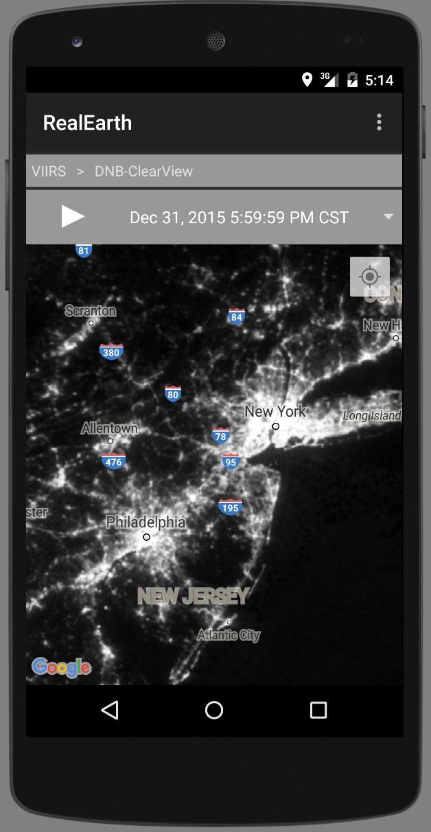
10 RealEarth Demo NPP VIIRS true color composite 10

11 RealEarth Demo River flood 11

12 RealEarth Demo River ice concentration over VIIRS DNB image 12


13 RealEarth Demo VIIRS sea ice product over Hudson Bay with Landsat image 13
14 End RealEarth Demo 14
15 More Ways to Visualize Mobile Apps ios and Android Desktop applications Add as WMS layer in qgis or ArcMap Add tile layers to ArcGIS Online Add KML to Google Earth 15
16 Mobile Apps WxSat Realtime satellite images Global Visible, IR, WV RealEarth Access to all RealEarth products User-customizable displays Available on ios and Android 16
17 WxSat: Basic Satellite Images Global composites of Visible, Infrared, and Water Vapor Images updated hourly Full native resolution ~4km IR/WV global ~1km VIS global Products are near realtime 17


18 WxSat: Features Free pan/zoom Display current location Simple political map overlay that can be toggled on/off Time selector Animation 18
19 RealEarth App Based on and incorporating lessons learned from WxSat App Instead of just 3 basic satellite products (WxSat), all products in RealEarth are available User-configurable favorites RealEarth App will be basis for future specialized apps for GOES-R and JPSS imagery and products 19
20 JPSS-focused App (in development) ISEE: Innovative Satellite Enhanced Exploration Real-time identification and notification of environmental conditions: Fire and smoke River ice and flooding Precipitation Etc Export to social media 20

 21")
21 RealEarth App on ios iphone (RealEarth products) 21


22 RealEarth App on ios ipad 22

23 RealEarth on Apple Watch Twitter. 23


24 RealEarth App on Android 24


25 Get the Apps! Visit us at SSEC booth 326! Attend talk at 4:45pm Monday RealEarth: Access to Real-time and Archive Satellite Data and Derived Products RealEarth Information: 25
26 Social Media at CIMSS Weather satellite blog Twitter YouTube Channel Instagram 26
27 Time Lines Blogging: Started August CIMSS GOES Gallery started January 1996 Twitter: Started June YouTube Channel: Started August 2013 CIMSS Satellite Blog UWSSEC Instagram Account: Started November 27
28 Why Blog? A picture is worth a thousand words Aligns with CIMSS goals of outreach/education Explanatory text focuses the reader s eye on the important part of the imagery, and what message for users to take away Assumption: Some readers are expert, some have zero knowledge. Blog written for relevancy to both. 28
 Noteworthy Weather (3) Record Events (4) Unusual Events (5) CIMSS Products!")
29 CIMSS Satellite Blog 40,000-50,000 hits daily Big Platform for education Good place to write about (1) News Events (2) Noteworthy Weather (3) Record Events (4) Unusual Events (5) CIMSS Products! (6) Satellite Issues 29
30 Examples of High-Impact Blog Posts Mali Air Crash Haiyan Landfall YouTube Video: 2100 Views YouTube Video (vis): 6800 views Air Asia Flight Bakken Shale Hurricane Sandy YouTube Video: views Typhoon Nuri YouTube video: plays! Satellite view of Chelyabinsk Meteor YouTube Video: 300 plays! Each of these is a great Teaching opportunity! 30

31 Plane Crash over Mali, July 2014: Was Weather Involved? Added: Day Night Band imagery shows flare at Crash site 31
32 Haiyan Landfall, late 2013 Biggest traffic of the year for a Blog post. COMS-1 data Day Night Band Links to YouTube Videos 32
33 Use Suomi NPP Day Night Band to show areal extent of gas extraction from Bakken Formation in North Dakota. (Also shows thermal signatures) How can satellite data monitor the Planet? 33

34 Many posts on Hurricane Sandy many links back to CIMSS websites to explain how the storm formed, weakened, re-strengthened, moved, etc. etc. Very high-impact, and great SRSO-R imagery to boot! 34
35 Blog Post on interesting transition from typhoon to strong extratropical storm in Being Sea. MTSAT-2 data, MIMIC TPW and Day Night Band Imagery as well as GOES-West. Demonstrates products that are useful as well as the breadth of data available from data center Teaches reader how tropical cyclones in the Pacific can affect weather in the USA 35
36 Meteor strike near Chelyabinsk Opportunity to show all the different satellite data available at CIMSS, and discuss why the satellite signatures appear and what they mean 36

37 Air Asia flight that went down in Java Sea while flying through tropical convection Image at left uses SSEC s RealEarth Display toggling between Google Maps and overlain IR imagery 37

38 COMS-1 Visible Data and MTSAT-2 IR data document the strong convection that the airline flew through 38
39 Why Tweet? As a way to direct people (or organizations) to a blog post As a way to monitor what others are seeing: CIMSS scientists cannot watch everything As a way to communicate with a NWS Office that has alerted us to an interesting event 39

40 @CIMSS_Satellite Followers Links to blog posts at CIMSS Blog or to animations 40

41 Tweet from NWS in Gray ME about an offshore vortex forced by topography of Gaspe Peninsula 41

42 Tweet to NWS in Gray ME about an offshore vortex forced by topography of Gaspe Peninsula with a link to the GOES-13 visible animation! 42
43 Why YouTube? Useful format Video creator can track number of views! SRSO-R especially results in very long loops that can be multi-hundreds of megabytes in an animated gif. Animated gifs have no start/stop feature 43
44 Why Instagram? Satellite imagery are just so pretty! Send out images that are beautiful Difficulty: Can t do much with a desktop need a smart phone or a tablet. 44


45 Thanks to RealEarth: CIMSS Blog: Also: Instagram: CIMSS_Satellite YouTube: CIMSS Satellite Blog, UWSSEC 45
Real-time Generation of. River Ice and Flood Products Derived from VIIRS Imagery
 Real-time Generation of 1 River Ice and Flood Products Derived from VIIRS Imagery David Santek 1, S. Li 2, N. Chaoch 3, J. Gerth 1, J. Hoffman 1, P. Alabi 3 1 University of Wisconsin-Madison/SSEC/CIMSS
Accessing satellite data via Apps, Web Map Servers, and the GOES-R Education Proving Ground. Margaret Mooney CIMSS/SSEC, UW-Madison
 Accessing satellite data via Apps, Web Map Servers, and the GOES-R Education Proving Ground Margaret Mooney CIMSS/SSEC, UW-Madison CIMSS & SSEC at the UW-Madison SSEC Data Center Incoming Data May, 2015
Preparing for NOAA s Next Generation GOES-R & JPSS
 Preparing for NOAA s Next Generation GOES-R & JPSS Mark Paese Deputy Assistant Administrator NOAA Environmental Satellite & Information Service (NESDIS) WMO Cg-17: Ensuring User Readiness for New Generation
Great Lakes Information Network GIS (Queryable by topic, geography, organization, and upload date 73 layers as of October, 2009)
") Google Earth Files for the Great Lakes and Beyond GLOS Mapping Workshop Alpena, Michigan November 9, 2009 David Hart GIS Specialist University of Wisconsin Sea Grant Institute GREAT LAKES Great Lakes Information
Google Earth Files for the Great Lakes and Beyond GLOS Mapping Workshop Alpena, Michigan November 9, 2009 David Hart GIS Specialist University of Wisconsin Sea Grant Institute GREAT LAKES Great Lakes Information
Use of big data, crowdsourcing and GIS in assessment of weather-related impact
 Use of big data, crowdsourcing and GIS in assessment of weather-related impact HK (Photo courtesy : GFS) PAN Chi-kin, Hong Kong Observatory (Photo courtesy : Roy Liu/China Daily) November 2017, KMA/WMO
JPSS GEONETCAST REQUIREMENTS DISCUSSION
 Joint Polar Satellite System (JPSS) JPSS GEONETCAST REQUIREMENTS DISCUSSION Mitch Goldberg Program Scientist Joint Polar Satellite System National Environmental Satellite, Data, and Information Service
McIDAS support of Suomi-NPP /JPSS and GOES-R L2
 McIDAS support of Suomi-NPP /JPSS and GOES-R L2 William Straka III 1 Tommy Jasmin 1, Bob Carp 1 1 Cooperative Institute for Meteorological Satellite Studies, Space Science and Engineering Center, University
Working with ArcGIS Online
 Esri International User Conference San Diego, CA Technical Workshops July 12, 2011 Working with ArcGIS Online Bern Szukalski, Deane Kensok Topics for this Session ArcGIS Online Overview ArcGIS Online Content
From ITPP, IAPP, IMAPP to CSPP Supporting Direct Broadcast Users Over Three Decades
 From ITPP, IAPP, IMAPP to CSPP Supporting Direct Broadcast Users Over Three Decades Allen Huang PI of IMAPP & CSPP-LEO allenh@ssec.wisc.edu Space Science & Engineering Center (SSEC) University of Wisconsin-Madison
EOS Direct Broadcast Real-Time Products for the US National Weather Service
 EOS Direct Broadcast Real-Time Products for the US National Weather Service Liam E. Gumley,, K. Strabala, J. Gerth,, S. Bachmeier, R. Dengel,, S. Dutcher, and J. Robaidek Liam.Gumley@ssec.wisc.edu University
Introduction to Google Mapping Tools
 Introduction to Google Mapping Tools Google s Mapping Tools Explore geographic data. Organize your own geographic data. Visualize complex data. Share your data with the world. Tell your story and educate
ArcGIS is Advancing. Both Contributing and Integrating many new Innovations. IoT. Smart Mapping. Smart Devices Advanced Analytics
 ArcGIS is Advancing IoT Smart Devices Advanced Analytics Smart Mapping Real-Time Faster Computing Web Services Crowdsourcing Sensor Networks Both Contributing and Integrating many new Innovations ArcGIS
Richard Butgereit Florida Division of Emergency Management
 1 There s An App for That! Emergency Management Apps and Resources http://floridaevacuates.com/locator for You and the Public Richard Butgereit richard.butgereit@em.myflorida.com g @ y Florida Division
Your Source for Global Aviation Forecasts
 Your Source for Global Aviation Forecasts (831) 238-5054 100 Sky Park Drive Monterey, CA 93940 Weather4Cast.com Live Weather Data Feeds Weather4Cast.com provides Live Aviation Weather Data Feeds formatted
Satellite User Readiness through Training: VISIT, SHyMet, WMO VLab, and Liaisons
 Satellite User Readiness through Training: VISIT, SHyMet, WMO VLab, and Liaisons Bernadette Connell 1 D. Bikos 1, S. Lindstrom 2, J. Torres 1, E. J. Szoke 1, E. L. Dagg 1, A. B. Schumacher 1, A. S. Bachmeier
Complete Weather Intelligence for Public Safety from DTN
 Complete Weather Intelligence for Public Safety from DTN September 2017 White Paper www.dtn.com / 1.800.610.0777 From flooding to tornados to severe winter storms, the threats to public safety from weather-related
Himawari-8 BUFR Development for Winds Processing and Radiances Cloud Mask, Cloud Phase, Cloud Height
 Sandy Supplemental Grant Recipient Quarterly Progress Report Himawari-8 BUFR Development for Winds Processing and Radiances Award Number: NA14NES4830006 The National Oceanic and Atmospheric Administration
Nurture Nature Center Receives Grant From National Oceanic and Atmospheric Administration To Study Flood Forecast and Warning Tools
 Nurture Nature Center Receives Grant From National Oceanic and Atmospheric Administration To Study Flood Forecast and Warning Tools One of four national awards by National Weather Service to advance weather
Recent forecast operations and outreach activities at the Canadian Hurricane Center (CHC)
") Recent forecast operations and outreach activities at the Canadian Hurricane Center (CHC) Chris Fogarty Canadian Hurricane Center, Halifax, Nova Scotia, Canada Outline CHC our beginnings and current role
Recent forecast operations and outreach activities at the Canadian Hurricane Center (CHC) Chris Fogarty Canadian Hurricane Center, Halifax, Nova Scotia, Canada Outline CHC our beginnings and current role
HVX-HURREVAC (Beta) Webinar Series
 Webinar Series") HVX-HURREVAC (Beta) Webinar Series Day 1 - An introduction to HURREVAC and the new web-based HVX platform 2018 HVX-HURREVAC Webinar Series 1. Intro to HURREVAC and General Overview of the Program (August
HVX-HURREVAC (Beta) Webinar Series Day 1 - An introduction to HURREVAC and the new web-based HVX platform 2018 HVX-HURREVAC Webinar Series 1. Intro to HURREVAC and General Overview of the Program (August
Discovery and Access of Geospatial Resources using the Geoportal Extension. Marten Hogeweg Geoportal Extension Product Manager
 Discovery and Access of Geospatial Resources using the Geoportal Extension Marten Hogeweg Geoportal Extension Product Manager DISCOVERY AND ACCESS USING THE GEOPORTAL EXTENSION Geospatial Data Is Very
A Vision for ArcGIS Applying Geography Everywhere
 A Vision for ArcGIS Applying Geography Everywhere WELCOME PURPOSE A Network of GIS Professionals Are Awakening the World to the Power of Web GIS You Your WORK Making a Difference Your Work Open Maps and
Monitoring Extreme Weather Events. February 8, 2010
 Monitoring Extreme Weather Events February 8, 2010 Extensive network of over 800 stations across the Prairies Good coverage across entire agriculture production region Network of networks strategy includes
1. Open IDV. There is a desktop link, choose version 3.0u1 or 3.0u2. It can take a few minutes to open.
 Page 1 Objectives: Become familiar with using a software package (IDV) to view satellite images Understand the differences between Visible, IR, and Microwave Imagery Observe the influence of dry air and
Himawari-8 BUFR Development for Winds Processing and Radiances - Packaging for Algorithm Integration Team (AIT)
") Sandy Supplemental Grant Recipient Quarterly Progress Report Himawari-8 BUFR Development for Winds Processing and Radiances - Packaging for Algorithm Integration Team (AIT) Award Number: NA14NWS4830052
Sandy Supplemental Grant Recipient Quarterly Progress Report Himawari-8 BUFR Development for Winds Processing and Radiances - Packaging for Algorithm Integration Team (AIT) Award Number: NA14NWS4830052
Sharing GIS to Empower the End User David Wray, Roanoke County, Virginia
 Sharing GIS to Empower the End User David Wray, Roanoke County, Virginia Sharing GIS to Empower the End User Roanoke County, Virginia Roanoke County, Virginia Population: 92,901 Area: 251 Square Miles
Feel free to ask for help also, we will try our best to answer your question or at least direct you to where you can find the answer.
 Page 1 Objectives: Become familiar with online resources and image searching tools Interpret different types of satellite imagery Learn about the variety of different types of TCs Part 1: Browse available
Time Storms By Jenny Randles
 Time Storms By Jenny Randles Storm Prediction Center Severe Weather Summaries - Past Storm Reports Enter date to retrieve (YYMMDD): Monthly and Annual Summaries; Monthly and annual tornado statistics and
IH 35 at Blanco River May 2015
 IH 35 at Blanco River May 2015 Presentation Objectives Background of historical damage assessment processes Introduction to Collector App ( Mat Peck) Collector App and Flood Damage Assessment (Katie Steele)
ArcGIS. for Server. Understanding our World
 ArcGIS for Server Understanding our World ArcGIS for Server Create, Distribute, and Manage GIS Services You can use ArcGIS for Server to create services from your mapping and geographic information system
SOCIAL MEDIA IN THE COMMUNICATIONS CENTRE
 SOCIAL MEDIA IN THE COMMUNICATIONS CENTRE Karen Gordon Gordon Strategy www.gordonstrategy.ca v 1 WHAT WE ARE GOING TO TALK ABOUT TODAY T h e s o c i a l m e d i a i n c i d e n t W h a t c a n h a p p
How to Effectively Use Weather Radar. Presented by: Robert Reale Company:
 How to Effectively Use Weather Radar Presented by: Robert Reale Company: Who Am I? What is WeatherWorks? WeatherWorks Private weather consulting firm located in Hackettstown, NJ Over 30 years in the snow
Hong Kong Observatory Summer Placement Programme 2018
 Hong Kong Observatory Summer Placement Programme 2018 Training Programme : supervise the student. A mentor from the Hong Kong Observatory with relevant expertise will Training Period : 8 weeks, starting
GPS Mapping with Esri s Collector App. What We ll Cover
 GPS Mapping with Esri s Collector App Part 1: Overview What We ll Cover Part 1: Overview and requirements Part 2: Preparing the data in ArcGIS for Desktop Part 3: Build a web map in ArcGIS Online Part
NWS Resources For Public Works
 NWS Resources For Public Works August 28th, 2016 Shawn DeVinny shawn.devinny@noaa.gov Meteorologist National Weather Service Twin Cities/Chanhassen, MN 1 APWA 2016 PWX 8/28/2016 National Weather Service
Improving Tropical Cyclone Forecasts by Assimilating Microwave Sounder Cloud-Screened Radiances and GPM precipitation measurements
 Improving Tropical Cyclone Forecasts by Assimilating Microwave Sounder Cloud-Screened Radiances and GPM precipitation measurements Hyojin Han a, Jun Li a, Mitch Goldberg b, Pei Wang a,c, Jinlong Li a,
How we use social media to communicate weather news
 How we use social media to communicate weather news The editorial met-team at METNorway WGCEF 12.10.2017 Norwegian Meteorological Institute INSTAGRAM - SHARING PICTURES Weather photos, 2-3 times a week.
11/19/14. Chapter 11: Hurricanes. The Atmosphere: An Introduction to Meteorology, 12 th. Lutgens Tarbuck
 Chapter 11: Hurricanes The Atmosphere: An Introduction to Meteorology, 12 th Lutgens Tarbuck Lectures by: Heather Gallacher, Cleveland State University! Hurricanes: " Hurricanes are intense centers of
USING TECHNOLOGY TO SHARE GIS David Wray, Roanoke County, Virginia
 USING TECHNOLOGY TO SHARE GIS David Wray, Roanoke County, Virginia Using Technology to Share GIS Roanoke County, Virginia Roanoke County, Virginia Population: 92,901 Area: 251 Square Miles Protected Areas:
ASSESSING THE ARTS COMMUNITY: Mapping with GIS and Social Media Tools
 ASSESSING THE ARTS COMMUNITY: Mapping with GIS and Social Media Tools Gary Coutu Associate Professor Department of Geography and Planning West Chester University July 15, 2014 Mapping with GIS and Social
On the assimilation of hyperspectral infrared sounder radiances in cloudy skies
 On the assimilation of hyperspectral infrared sounder radiances in cloudy skies Jun Li 1, Pei Wang 1, Zhenglong Li 1, Jinlong Li 1 and Mitchell D. Goldberg 2 1 Cooperative Institute for Meteorological
Frank Revitte National Weather Service. Weather Forecast Office New Orleans/Baton Rouge
 Frank Revitte National Weather Service Weather Forecast Office New Orleans/Baton Rouge Above normal activity 17 Total Named Storms 7 Tropical Storms 4 Hurricanes 6 Major Hurricanes Not the most active,
Smart use of Geographic Information System (GIS) platform for delivering weather information and nowcasting services
 platform for delivering weather information and nowcasting services") Smart use of Geographic Information System (GIS) platform for delivering weather information and nowcasting services C. K. Pan Hong Kong Observatory Hong Kong, China It is a world of beauty Source: Image
Smart use of Geographic Information System (GIS) platform for delivering weather information and nowcasting services C. K. Pan Hong Kong Observatory Hong Kong, China It is a world of beauty Source: Image
DERIVING ATMOSPHERIC MOTION VECTORS FROM AIRS MOISTURE RETRIEVAL DATA
 DERIVING ATMOSPHERIC MOTION VECTORS FROM AIRS MOISTURE RETRIEVAL DATA David Santek 1, Sharon Nebuda 1, Christopher Velden 1, Jeff Key 2, Dave Stettner 1 1 Cooperative Institute for Meteorological Satellite
ERTH 365 Homework #2: Hurricane Harvey. 100 points
 ERTH 365 Homework #2: Hurricane Harvey 100 points Due by 6pm, Tuesday 30 October 2018, ELECTRONIC SUBMISSON BY EMAIL ONLY BY 6PM (send to klevey@sfsu.edu) (acceptable formats: MS Word, Google Doc, plain
Web-based Maps in Support of Teaching Weather and Physical Geography
 Web-based Maps in Support of Teaching Weather and Physical Geography, Proceedings of the Workshop on Maps and the Internet, Journal of South China Normal University (Natural Science Edition), July 2001,
The Delaware Environmental Monitoring & Analysis Center
 The Delaware Environmental Monitoring & Analysis Center Tina Callahan Delaware Estuary Science & Environmental Summit 2013 January 27-30, 2013 What is DEMAC? Delaware Environmental Monitoring & Analysis
Web GIS Administration: Tips and Tricks
 EdUC 2017 July 8 th, 2017 Web GIS Administration: Tips and Tricks Geri Miller Agenda Concerns Acknowledged User Management Content Management Monitoring Licensing and logins Sophistication of IT support
You are Building Your Organization s Geographic Knowledge
 You are Building Your Organization s Geographic Knowledge And Increasingly Making it Available Sharing Data Publishing Maps and Geo-Apps Developing Collaborative Approaches Citizens Knowledge Workers Analysts
Jun Mitch Goldberg %, Pei Timothy J. Schmit &, Jinlong Zhenglong and Agnes
 Progress on the assimilation of advanced IR sounder radiances in cloudy skies Jun Li @, Mitch Goldberg %, Pei Wang @#, Timothy J. Schmit &, Jinlong Li @, Zhenglong Li @, and Agnes Lim @ @CIMSS, University
Add NOAA nowcoast Layers to Maps
 WebEOC Maps Add-on Quick Reference Guide Add NOAA nowcoast Layers to Maps Overview With Maps Add-on, you can configure an unlimited number of map layers. These layers allow you to control the data you
Weather and Climate: Satellite Meteorology
 LIVE INTERACTIVE LEARNING @ YOUR DESKTOP Weather and Climate: Satellite Meteorology Presented by: Rudo Kashiri April 4, 2013 6:30 p.m. 8:00 p.m. Eastern time 1 2 http://learningcenter.nsta.org NSTA Learning
Great Lakes. David Hart Wisconsin Sea Grant Cindy Hagley Minnesota Sea Grant Great Lakes Mapping Webinar #2 Conservation Ontario
 Great Lakes Mapping Mash ups David Hart Wisconsin Sea Grant Cindy Hagley Minnesota Sea Grant Great Lakes Mapping Webinar #2 Conservation Ontario Friday, January 21, 2011 Goals Webinar #1 The goals of the
CSPP Geo. CSPP/IMAPP Users Group Meeting 2015 Darmstadt, Germany 15 April 2015
 CSPP Geo Graeme Martin, Liam Gumley, Nick Bearson, Jessica Braun, Geoff Cureton, Ray Garcia, Tommy Jasmin, Scott Mindock, Kathy Strabala University of Wisconsin Madison, Space Science & Engineering Center
Are You Ready For Hurricane Season? 2018 Hurricane Talk B Y : S T O R M T E A M 8 M E T E O R O L O G I S T J U L I E P H I L L I P S
 Are You Ready For Hurricane Season? 2018 Hurricane Talk B Y : S T O R M T E A M 8 M E T E O R O L O G I S T J U L I E P H I L L I P S About Me I am Currently a Weekday Meteorologist at WFLA Channel 8.
Using McIDAS-V for Satellite-Based Thunderstorm Research and Product Development
 Using McIDAS-V for Satellite-Based Thunderstorm Research and Product Development Kristopher Bedka UW-Madison, SSEC/CIMSS In Collaboration With: Tom Rink, Jessica Staude, Tom Whittaker, Wayne Feltz, and
Impact of assimilating the VIIRS-based CrIS cloudcleared radiances on hurricane forecasts
 Impact of assimilating the VIIRS-based CrIS cloudcleared radiances on hurricane forecasts Jun Li @, Pei Wang @, Jinlong Li @, Zhenglong Li @, Jung-Rim Lee &, Agnes Lim @, Timothy J. Schmit #, and Mitch
Satellite-based Convection Nowcasting and Aviation Turbulence Applications
 Satellite-based Convection Nowcasting and Aviation Turbulence Applications Kristopher Bedka Cooperative Institute for Meteorological Satellite Studies (CIMSS), University of Wisconsin-Madison In collaboration
Weather Analysis and Forecasting
 Weather Analysis and Forecasting An Information Statement of the American Meteorological Society (Adopted by AMS Council on 25 March 2015) Bull. Amer. Meteor. Soc., 88 This Information Statement describes
Remote Sensing in Meteorology: Satellites and Radar. AT 351 Lab 10 April 2, Remote Sensing
 Remote Sensing in Meteorology: Satellites and Radar AT 351 Lab 10 April 2, 2008 Remote Sensing Remote sensing is gathering information about something without being in physical contact with it typically
Overview of the Tropical Cyclone Guidance Project
 Overview of the Tropical Cyclone Guidance Project Dr. Jonathan L. Vigh With thanks to Mahsa Mirzargar (Univ. of Miami) Shanghai Typhoon Institute 09 July 2018 NCAR is sponsored by the National Science
New NASA Ocean Observations and Coastal Applications
 New NASA Ocean Observations and Coastal Applications Duane Armstrong Chief, Applied Science & Technology Project Office August 20, 2014 1 Outline NASA s new Earth Science Ocean Science Missions for 2014
Climate Risk Visualization for Adaptation Planning and Emergency Response
 Climate Risk Visualization for Adaptation Planning and Emergency Response NCR Flood Fact Finding Workshop Ricardo Saavedra ricardo@vizonomy.com Social Media, Mobile, and Big Data St. Peter s Basilica,
The UW-CIMSS Advanced Dvorak Technique (ADT) : An Automated IR Method to Estimate Tropical Cyclone Intensity
 : An Automated IR Method to Estimate Tropical Cyclone Intensity") The UW-CIMSS Advanced (ADT) : An Automated IR Method to Estimate Tropical Cyclone Intensity Timothy Olander and Christopher Velden University of Wisconsin Madison, USA Cooperative Institute for Meteorological
The UW-CIMSS Advanced (ADT) : An Automated IR Method to Estimate Tropical Cyclone Intensity Timothy Olander and Christopher Velden University of Wisconsin Madison, USA Cooperative Institute for Meteorological
Why Hydrological Services are Important to Business
 Why Hydrological Services are Important to Business Dr. David Green Program Manager, Disasters Earth Science Division David.s.green@nasa.gov May 8, 2018 2 Communities and Areas of Intensive Risk Socio-Economic
The Nuts and Bolts of These Community Preparedness Recognition Programs
 The Nuts and Bolts of These Community Preparedness Recognition Programs Bill Sammler Warning Coordination Meteorologist NOAA s National Weather Service, Wakefield VA http://weather.gov/akq Why is StormReady
Your web browser (Safari 7) is out of date. For more security, comfort and. the best experience on this site: Update your browser Ignore
 is out of date. For more security, comfort and. the best experience on this site: Update your browser Ignore") Your web browser (Safari 7) is out of date. For more security, comfort and Activityengage the best experience on this site: Update your browser Ignore Introduction to GIS What is a geographic information
Your web browser (Safari 7) is out of date. For more security, comfort and Activityengage the best experience on this site: Update your browser Ignore Introduction to GIS What is a geographic information
What is CERA? Coastal Emergency Risks Assessment
 What is CERA? Coastal Emergency Risks Assessment Visualization tool using OGC standards Displays the outputs from the ADCIRC storm surge model or other coastal models Represents the maps on interactive
SATELLITE SIGNATURES ASSOCIATED WITH SIGNIFICANT CONVECTIVELY-INDUCED TURBULENCE EVENTS
 SATELLITE SIGNATURES ASSOCIATED WITH SIGNIFICANT CONVECTIVELY-INDUCED TURBULENCE EVENTS Kristopher Bedka 1, Wayne Feltz 1, John Mecikalski 2, Robert Sharman 3, Annelise Lenz 1, and Jordan Gerth 1 1 Cooperative
McIDAS-X Software Development and Demonstration. PDA Animated Weather (PAW) Status by Russ Dengel. Dave Santek and Jay Heinzelman.
 Status by Russ Dengel. Dave Santek and Jay Heinzelman.") McIDAS-X Software Development and Demonstration Dave Santek and Jay Heinzelman 2 June 2009 PDA Animated Weather (PAW) Status by Russ Dengel Overview McIDAS-X 2008, 2009.1 McIDAS-XRD 2008, 2009.1 Software
McIDAS-X Software Development and Demonstration Dave Santek and Jay Heinzelman 2 June 2009 PDA Animated Weather (PAW) Status by Russ Dengel Overview McIDAS-X 2008, 2009.1 McIDAS-XRD 2008, 2009.1 Software
Image Services Providing Access to Scientific Data at NOAA/NCEI
 Image Services Providing Access to Scientific Data at NOAA/NCEI Jesse Varner Cooperative Institute for Research in Environmental Sciences (CIRES), University of Colorado John Cartwright NOAA National Centers
ArcGIS Platform For NSOs
 ArcGIS Platform For NSOs Applying GIS and Spatial Thinking to Official Statistics Esri UC 2014 Demo Theater Applying GIS at the NSO Generic Statistical Business Process Model (GSBPM) 1 Specify Needs 2
Understanding Common Storms and Weather Phenomena
 Understanding Common Storms and Weather Phenomena Overview: In teaching students about common storms and weather phenomena, the goal is for the student to be able to investigate and understand the basic
A New Numerical Weather Prediction Approach to the NDFD's Sky Cover Grid
 A New Numerical Weather Prediction Approach to the NDFD's Sky Cover Grid Jordan Gerth Graduate Research Assistant Cooperative Institute for Meteorological Satellite Studies (CIMSS) and Department of Atmospheric
Impact of Tropical Cyclones - Malaysia's Experience
 Impact of Tropical Cyclones - Malaysia's Experience ALUI BAHARI MALAYSIAN METEOROLOGICAL DEPARTMENT MINISTRY OF SCIENCE, TECHNOLOGY AND INNOVATION SCOPE Introduction Case Studies of Tropical Cyclones Impacting
Hurricane Preparation and Recovery. October 11, 2011 Jon Nance, Chief Engineer, NCDOT
 Hurricane Preparation and Recovery October 11, 2011 Jon Nance, Chief Engineer, NCDOT North Carolina & Severe Weather Our state often bears the brunt of storms, which include: Ice storms Snow storms Heavy
9A.2 Tropical Cyclone Satellite Tutorial Online Through The COMET Program
 9A.2 Tropical Cyclone Satellite Tutorial Online Through The COMET Program Thomas F. Lee Steven D. Miller F. Joseph Turk Jeffrey D. Hawkins Naval Research Laboratory, Monterey CA Patrick Dills Sherwood
UDOT Weather Program Traffic Operations Center
 UDOT Weather Program Traffic Operations Center Presentation Goals You MUST account for weather in your Traffic Management program Provide you with information on proven tools and strategies You NEED a
CLAVR-x is the Clouds from AVHRR Extended Processing System. Responsible for AVHRR cloud products and other products at various times.
 CLAVR-x in CSPP Andrew Heidinger, NOAA/NESDIS/STAR, Madison WI Nick Bearson, SSEC, Madison, WI Denis Botambekov, CIMSS, Madison, WI Andi Walther, CIMSS, Madison, WI William Straka III, CIMSS, Madison,
WMO Coordination Group on Satellite Data Requirements for Region III and IV Sept 5-8, 2016 Willemstad, Curaçao
 WMO Coordination Group on Satellite Data Requirements for Region III and IV Sept 5-8, 2016 Willemstad, Curaçao 1. Current Satellite Reception 2. Preparation for Next-Gen GOES-R JPSS 3. Satellite Data Applications
Introduction to ArcGIS Server Development
 Introduction to ArcGIS Server Development Kevin Deege,, Rob Burke, Kelly Hutchins, and Sathya Prasad ESRI Developer Summit 2008 1 Schedule Introduction to ArcGIS Server Rob and Kevin Questions Break 2:15
Geo-Enabling Digital India. 15 th Esri India User Conference GIS and Smart Cities
 15 th Esri India User Conference 2014 GIS and Smart Cities 15 th Esri India User Conference 2014 GIS and Smart Cities Agendra Kumar President, Esri India Our World Is Facing Serious Challenges Our World
Fifty Years of Operational Environmental Satellites: The U.S. Experience
 United Nations Committee on the Peaceful Uses of Outer Space Vienna, Austria June 15, 2010 Fifty Years of Operational Environmental Satellites: The U.S. Experience Mr. Charles Baker Deputy Assistant Administrator
Tropical Update. 5 PM EDT Sunday, September 10, 2017 Hurricane Irma, Hurricane Jose, Tropical Wave (60%)
") Tropical Update 5 PM EDT Sunday, September 10, 2017 Hurricane Irma, Hurricane Jose, Tropical Wave (60%) This update is intended for government and emergency response officials, and is provided for informational
Tropical Update 5 PM EDT Sunday, September 10, 2017 Hurricane Irma, Hurricane Jose, Tropical Wave (60%) This update is intended for government and emergency response officials, and is provided for informational
Exercise Brunswick ALPHA 2018
 ALPHA Exercise Brunswick ALPHA 2018 Who we are (our structure) What we do (our forecasts) How you can access the information Tropical cyclone information (basic) Overview of the products used for Exercise
AOMSUC-6 Training Event
 Effective use of high temporal and spatial resolution Himawari-8 data AOMSUC-6 Training Event Bodo Zeschke Australian Bureau of Meteorology Training Centre Australian VLab Centre of Excellence Content
Title: Storm of the Century: Documenting the 1993 Superstorm
 A. PAIIF 2011 Cover Page Title: Storm of the Century: Documenting the 1993 Superstorm Point of Contact: Name: Alex Granger Email: alex.granger@noaa.gov Phone Number: 571-555-9278 Mailing Address: Research
International Cooperation in Operational Environmental Satellites: The U.S. Experience
 Committee on the Peaceful Uses of Outer Space Science and Technology Sub committee Forty seventh session February 17, 2010 Vienna, Austria International Cooperation in Operational Environmental Satellites:
Short Discription of NMHS Activity
 The 5th Meeting of the Coordinating Group of the RA II WIGOS Satellite Project 21 October, Vladivostok city, Russky Island, Russia Far Eastern Federal University FSM COUNTRY REPORT SOSTEN SOS, WSS OFFICE
National Climatic Data Center Data Management Issues Tom Karl Director, NOAA s National Climatic Data Center
 National Climatic Data Center Data Management Issues Tom Karl Director, NOAA s National Climatic Data Center Opening Meeting NOAA Science Advisory Board s Data Archiving and Access Requirements Working
How Detailed Weather Data and Geospatial Tools Can Be Used to Increase Net Income
 How Detailed Weather Data and Geospatial Tools Can Be Used to Increase Net Income Session 475 Tuesday, June 10 10:30 11:30 am IASA 86 TH ANNUAL EDUCATIONAL CONFERENCE & BUSINESS SHOW How Detailed Weather
How does NASA study hurricanes? 17 August 2015, by Max Gleber
 How does NASA study hurricanes? 17 August 2015, by Max Gleber Hurricanes are the most powerful weather event on Earth. NASA's expertise in space and scientific exploration contributes to essential services
Jordan Gerth Cooperative Institute for Meteorological Satellite Studies University of Wisconsin at Madison 27 January 2011
 Jordan Gerth Cooperative Institute for Meteorological Satellite Studies University of Wisconsin at Madison 27 January 2011 91 st American Meteorological Society Annual Meeting First Conference on Transition
Data Format and Visualization Agenda
 Data Format and Visualization Agenda- 7.2.2 ET-SUP-8 (14.04.2014) Suman Goyal, Satellite Meteorology Division, India Meteorological Department, Suman_goyal61@yahoo.co.in Visualization Methods The satellite
16D.3 EYEWALL LIGHTNING OUTBREAKS AND TROPICAL CYCLONE INTENSITY CHANGE
 16D.3 EYEWALL LIGHTNING OUTBREAKS AND TROPICAL CYCLONE INTENSITY CHANGE Nicholas W. S. Demetriades and Ronald L. Holle Vaisala Inc., Tucson, Arizona, USA Steven Businger University of Hawaii Richard D.
HISTORY OF GIS AND ESRI
 HISTORY OF GIS AND ESRI First Developed by Dr. Roger Tomlinson in Canada 1960 (CGIS Canadian geographic system) The system was designed to inventory land use and assist in the management of natural resources
Mapping rainfall and flooding
 Mapping rainfall and flooding BY DAVID WALBERT Although Hurricane Floyd was the biggest storm of 1999 and the one most remembered, eastern North Carolina was hit by three hurricanes in a six-week period
Atmospheric Motions Derived From Space Based Measurements: A Look To The Near Future. James F.W. Purdom
 Atmospheric Motions Derived From Space Based Measurements: A Look To The Near Future James F.W. Purdom Director, Office of Research and Applications NOAA/NESDIS 1. Introduction This short note addresses
Observations Team: Satellite Observation Update. John Knaff NOAA/NESDIS Regional and Mesoscale Meteorology Branch
 Observations Team: Satellite Observation Update John Knaff NOAA/NESDIS Regional and Mesoscale Meteorology Branch 1 FY12 Satellite Milestones: i. CIRA/RAMMB continue maintaining and populating real-time
Tool for Storm Analysis Using Multiple Data Sets
 Tool for Storm Analysis Using Multiple Data Sets Robert M. Rabin 1,2 and Tom Whittaker 2 1 NOAA/National Severe Storms Laboratory, Norman OK 73069, USA 2 Cooperative Institute for Meteorological Satellite