The Impacts of the 2008 Hurricane Season On Trinidad and Tobago
|
|
|
- Martha McCormick
- 5 years ago
- Views:
Transcription
1 Synoptic Branch Piarco International Airport Piarco, Trinidad Telephone: Fax: The Impacts of the 2008 Hurricane Season On Trinidad and Tobago The 2008 Atlantic hurricane season has been an active one, especially within the Caribbean Region. All tropical cyclones which formed in the Atlantic Basin passed to the north of Trinidad and Tobago, as such there were no direct impact from any cyclones. Spiral bands associated with Hurricane Omar during the month of October affected both Trinidad and Tobago to some small degree. No flooding, property damage or agricultural loses were attributed to the passage of this system. On the 7 th September, flood waters swept away a 30 month old baby girl who slipped out of her mother s arms and drowned while crossing Crooks River at Rockleyvale, Scarorobough Tobago. Raging floodwaters resulting from torrential showers from the same weather system also caused extensive damage to homes, agricultural crops and poultry farms in Southern areas of Trinidad. This event produced over 78mm of rainfall and wind gusts in excess of 40kmh. Torrential downpours on Tuesday 18 th November in Port of Spain and its environs produced extensive flooding in the heart of the city. In fact there was a complete shutdown of transportation for more than eight hours in many parts of the city. Two deaths occurred due to this rainfall event. Interestingly, the Met Services reporting station, approximately 12 miles east of Port of Spain, recorded less than 1mm of rainfall, however, more than 70mm of rainfall was measured in the capital for this event. During the early part of the season there were marked increases in the incidence of flash flooding, particularly in Trinidad. The Meteorological Services attributes this partially to an increase in rainfall intensities coupled with clogged waterways/watercourses and faster run-offs which have occurred as a result of widespread housing and infrastructural developments. This resulted in the Meteorological Services reintroducing the issuing of Information Bulletins, as opposed to Severe Weather Bulletins, for events that were to last for a period of two to four hours but were forecast to produce street flooding and/or flash flooding. What is also worth mentioning is the increase in sightings of funnel clouds during the entire Hurricane Season. The Meteorological Services received increasing demands from stakeholders both in the private and public sectors for a seven day weather outlook. Due to the limited resources available in generating a resilient and sustained seven day forecast, the Office introduced
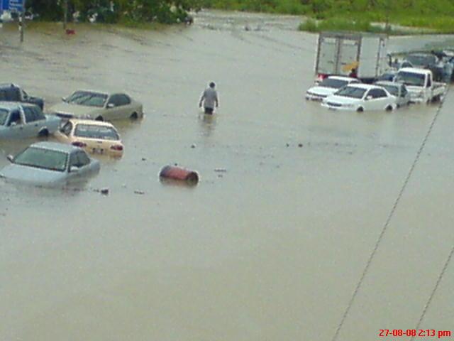
2 a four day outlook beginning Monday evening and ending Friday afternoon together with a three day outlook, beginning Friday evening and ending Monday afternoon. The outlook includes a colour coded probability scheme, which highlights different levels of probabilities. (See Appendix D). Several other severe weather episodes occurred over Trinidad and Tobago during the hurricane season of 2008 and can be attributed to the passage of Tropical Waves and ITCZ dominance. Also, the passage of tropical cyclones well to the north of the Islands of the Eastern Caribbean, resulted in a breakdown of the low-mid level wind-field over the south-east Caribbean, with the largest island Trinidad being mostly influenced. Temperatures soured in excess of 35 degrees Celsius at times, these conditions assisted in the development of west coast convection (land-sea breeze effect) which produced flooding in Port-of-Spain and environs and other parts of Western Trinidad sporadically during the months of September, October and November. SUMMARY OF BULLETINS ISSUED Severe Weather Bulletins The first bulletin for the 2008 season was issued on the 23 rd August and this was an Information Bulletin which was issued at 8:00 a.m. and this was followed by a Severe Weather Bulletin which was issued on the same day at 3 p.m. This was due to a low pressure system which resulted in severe weather affecting Trinidad, Tobago, Grenada and its Dependencies. Rainfall measured was 79mm; gusts of 56kmh and a maximum temperature of 35 deg Celsius were recorded. An Information bulletin was issued at 2:00 pm on Wednesday 27 th August informing the general public of the possibility of torrential showers and thundershowers during the afternoon period. South Trinidad experienced flooding following several periods of torrential rainfall on Wednesday 27 th August. Parts of the Solomon Hochoy Highway - the main link between South and North Trinidad - were under water, leading to hundreds of motorists being stranded. (See photos in Appendix A). Motorists were forced to stop their cars and wait while others had no choice but to push their vehicles to the shoulder of the highway after their vehicles stalled. Some motorists had to wait for over three hours before the waters subsided sufficiently for them to proceed.
3 A Bulletin was issued on the 7 th September 2008 for Trinidad and Tobago due to the passage of a very active Tropical Wave which was enhanced by an upper level trough. The maximum temperature recorded was 34.8 C. Scattered showers and thundershowers occurred from mid-morning until late evening. Flooding occurred in many areas in both Trinidad and Tobago. On this day regretfully, Tobago recorded the death of a child due to raging flood waters. Images from Tobago due to this meteorological event are highlighted in Appendix B. On the 3 rd October, Severe Weather Bulletin #1 was issued at 7:00 a.m. for both Trinidad and Tobago. This was due to the passage of an active Tropical Wave and an upper-level low which provided the necessary upper level diffluent flow. The bulletin was discontinued just after midday. Confirmed reports from Tobago indicated that the roof of Lambeau E.C. School was partially blown off and there was extensive flooding damage, power lines in the Mount Pleasant area were also severely affected. A 55kmg wind gust was recorded during this weather event. Widespread rainfall over the period 14 th to 19 th November resulted in two (2) deaths, extensive damage to properties, livestock and the agricultural industry. Nathaniel Poon (three years old) was killed after landslide destroyed her St Anns home on Tuesday 18 th November. Pensioner Barbara Emmanuel, 67, was killed after landslide destroyed her Le Platte Village, Maraval home on Sunday 16 th November. Dozens of cars had to be wrecked after being washed away in floods over the weekend; one bridge on the eastbound lane of the Churchill Roosevelt Highway collapsed into the river; houses in Mon Repos and Laventille, collapsed. Several areas suffered after Landslides wreaked havoc in their locality viz. La Platte Village, Maraval, Maracas, Lady Young Road, Morvant and some others. A number of Severe Weather Bulletins and Information Bulletins were issued during this period. Total rainfall measured for this six day period was 60.7mm with 50% falling on the 14 th. (See Appendix C).
4 Information Bulletins Information Bulletins and Severe Weather Bulletins dates are tabled below: JUNE JULY AUGUST SEPTEMBER OCTOBER NOVEMBER 1 st nd rd SWB - T IB - T - 4 th th th th SWB T - U th IB I - U IB - U - 9 th IB - T - 10 th IB I - T - 11 th IB - D th th th IB - I 15 th IB - I 16 th IB - I 17 th IB - I 18 th IB - D 19 th IB T - I IB - D 20 th st nd rd - - IB - SWB - IB - D - L 24 th IB - D 25 th th th IB - D - 28 th IB - D - 29 th IB - D - 30 th st Legend: L = Low Pressure System I = ITCZ D = Diurnal Convection SWB = Severe Weather Bulletin U = Upper Level Trough / Diffluence T = Tropical Wave IB = Information Bulletin

5 Appendix A
6

7 Appendix B MAJOR FLOODING AT DOWN TOWN SCARBOROUGH ON Sept. 7th DUE TO HEAVY RAINS IN THE EARLY HOURS OF THE MORNING RESULTING IN MAJOR FLOODING DOWNTOWN SCARBOROUGH. THE FOLLOWING AREAS WERE IMPACTED: GARDEN SIDE STREET, CARRINGTON STREET, MILFORD ROAD AND WILSON ROAD. A NUMBER OF BANKS AND SEVERAL BUSINESS PLACES WERE FLOODED OUT. NO ESTIMATE OF DAMAGES WAS REPORTED.

8


9 Appendix C

10 mpassable: The eastern end of South Quay, Port of Spain, was still impassable yesterday morning as the floodwaters remained from Tuesday's downpour. -Photo: DELLA ANN STEWART BIG MESS: Workmen at the site yesterday where a bridge along the east-bound lane of the Churchill-Roosevelt Highway, just after the Macoya intersection, caved in on Monday night. - Photo: ABRAHAM DIAZ

11
12 Appendix D THREE-DAY WEATHER OUTLOOK DATE: FRIDAY 26 TH SEPTEMBER 2008 ISSUED AT: 3.00PM FRIDAY 26 TH EVENING/NIGHT (CODE BLUE) GENERALLY FAIR CHANCE OF ISOLATED SHOWERS SYNOPSIS: RIDGE OF HIGH PRESSURE IN GENERAL AREA. SATURDAY 27 TH (CODE BLUE) FAIR TO PARTLY CLOUDY ISOLATED SHOWERS WITH CHANCE OF AFTERNOON THUNDERSHOWER SYNOPSIS: RIDGE OF HIGH PRESSURE IN GENERAL AREA SUNDAY 14 TH (CODE ORANGE) OCCASIONAL SHOWERS AND ISOLATED THUNDERSHOWERS. THERE IS THE CHANCE OF STREET AND FLASH FLOODING AND GUSTY WINDS IN THUNDERSHOWERS. THIS IS FORECAST TO BEGIN BY AFTERNOON AND MAY CONTINUE FOR AT LEAST A FEW HOURS. SYNOPSIS: FRONT-END OF TROPICAL WAVE OVER TRINIDAD AND TOBAGO. MONDAY 15 TH (CODE ORANGE) OCCASIONAL SHOWERS AND ISOLATED THUNDERSHOWERS THE PROBABILITY OF STREET AND FLASH FLOODING AND GUSTY WINDS WILL CONTINUE. SYNOPSIS: DUE TO PASSAGE OF TROPICAL WAVE TROPICAL STORM ACTIVITY IS NOT EXPECTED TO AFFECT T&T DURING THIS PERIOD Status Code: BLUE: NO SIGNIFICANT WEATHER FEATURES (PROBABILITY < 25%) GREEN: LOW POTENTIAL OF SIGNIFICANT WEATHER (PROBABILITY >25% <40%) ORANGE: MEDIUM POTENTIAL OF SIGNIFICANT (SEVERE) WEATHER (PROBABILITY >40% <70%) RED: HIGH POTENTIAL OF SIGNIFICANT OR SEVERE WEATHER (PROBABILITY > 70%) M. Noel Ag. Assistant Director Submitted by Marlon Noel Written by Marlon Noel & Shakeer Baig
The Impact of 2007 Atlantic Hurricane Season on Dominica
 The Impact of 2007 Atlantic Hurricane Season on Dominica DOMINICA November 2007 Main Activities Freak Twister on June 21st 2007. Hurricane Dean on August 16th to 17th 2007 Active Tropical Wave on September
Marshall Alexander Forecaster Commonwealth of Dominica
 Marshall Alexander Forecaster Commonwealth of Dominica Dominica 2015 Impacts Tropical Storm Danny (August 24 th ) Tropical Storm Erika (August 27 th ) Tropical Storm Grace (Remnants) (September 10 th -11
WEATHER SYSTEMS IMPACTING THE CAYMAN ISLANDS Prepared by the staff of the Cayman Islands National Weather Service
 WEATHER SYSTEMS IMPACTING THE CAYMAN ISLANDS 2008 Prepared by the staff of the Cayman Islands National Weather Service TROPICAL STORM DOLLY Formed 194 miles west of Grand Cayman July 19 th. The tropical
WEEKLY WEATHER OUTLOOK BELIZE, CENTRAL AMERICA
 WEEKLY WEATHER OUTLOOK BELIZE, CENTRAL AMERICA PERIOD: Sunday, June 17 until Monday, June 25, 2012 DATE ISSUED: Sunday, June 17, 2012; 3:00 pm RFrutos EcoSolutions & Services SYNOPSIS: An upper level trough
WEEKLY WEATHER OUTLOOK BELIZE, CENTRAL AMERICA
 WEEKLY WEATHER OUTLOOK BELIZE, CENTRAL AMERICA PERIOD: Sunday, July 1 until Monday, July 9, 2012 DATE ISSUED: Sunday, July 1, 2012 3:00 pm RFrutos EcoSolutions & Services SYNOPSIS: The features of interest
A surge in the easterlies and an influx of moisture and instability is inducing
 WEEKLY WEATHER OUTLOOK BELIZE, CENTRAL AMERICA PERIOD: Monday-Monday, July 16-23, 2012 DATE ISSUED: Monday, July 16, 2012 6:00 am RFrutos EcoSolutions & Services SYNOPSIS: A number of features of interest
Significant Flooding Expected
 Significant Flooding Expected Decision Support Briefing #5 As of: 9:00 AM September 14, 2018 What Has Changed? Flash Flood Watch now in effect for part of area, will be expanded later today 9/14/2018 9:23
ovember 2008 Antigua and Barbuda Meteorological Service
 ovember 2008 Antigua and Barbuda Meteorological Service The Atlantic Hurricane Season Summary 2008 Special Focus on Antigua and Barbuda The Season in Brief Sixteen (16) named storms formed in the Atlantic
IWT Scenario 1 Integrated Warning Team Workshop National Weather Service Albany, NY October 31, 2014
 Integrated Warning Team Workshop National Weather Service Albany, NY October 31, 2014 23 24 25 26 27 Scenario 1 Timeline November 23-27 Sun Mon Tue Wed Thu Thanksgiving Day Sunday, Nov. 23 @ 430 pm NWS
An upper to mid level circulation (Low) in the NW Caribbean is
 in the NW Caribbean is") WEEKLY WEATHER OUTLOOK BELIZE, CENTRAL AMERICA PERIOD: Monday-Monday, Oct. 1 October 8, 2012 DATE ISSUED: Monday, Oct 1, 2012 6:00 am RFrutos EcoSolutions & Services SYNOPSIS: An upper to mid level circulation
WEEKLY WEATHER OUTLOOK BELIZE, CENTRAL AMERICA PERIOD: Monday-Monday, Oct. 1 October 8, 2012 DATE ISSUED: Monday, Oct 1, 2012 6:00 am RFrutos EcoSolutions & Services SYNOPSIS: An upper to mid level circulation
DIRECTION INTERREGIONALE ANTILLES-GUYANE
 DIRECTION INTERREGIONALE ANTILLES-GUYANE SUMMARY OF THE 2010 HURRICANE SEASON IN THE FRENCH WEST INDIES ( Martinique, Guadeloupe, St Barthelemy and St Martin ) Among the nineteen named tropical cyclones
WEEKEND WEATHER OUTLOOK BELIZE, CENTRAL AMERICA
 WEEKEND WEATHER OUTLOOK BELIZE, CENTRAL AMERICA PERIOD: Friday, July 6 until Monday, July 9, 2012 DATE ISSUED: Friday, July 6, 2012; 9:00 am RFrutos SYNOPSIS: An active tropical wave (TW) just west of
WEEKEND WEATHER OUTLOOK BELIZE, CENTRAL AMERICA
 WEEKEND WEATHER OUTLOOK BELIZE, CENTRAL AMERICA PERIOD: Friday, July 13 until Monday, July 16, 2012 DATE ISSUED: Friday, June 13, 2012, 9:00 am RFrutos SYNOPSIS: A weak pressure gradient over the NW Caribbean
Tropical Update. 5 AM EDT Tuesday, September 12, 2017 Post-Tropical Cyclone Irma, Hurricane Jose, & Tropical Wave (10%)
") Tropical Update 5 AM EDT Tuesday, September 12, 2017 Post-Tropical Cyclone Irma, Hurricane Jose, & Tropical Wave (10%) This update is intended for government and emergency response officials, and is provided
Tropical Update 5 AM EDT Tuesday, September 12, 2017 Post-Tropical Cyclone Irma, Hurricane Jose, & Tropical Wave (10%) This update is intended for government and emergency response officials, and is provided
Tropical Cyclone Isaac (AL092012)
") Tropical Cyclone Isaac (AL092012) Event Briefing, Central Caribbean Impacts Caribbean Risk Managers Ltd Facility Supervisor 27 August 2012 Facility Supervisor: Caribbean Risk Managers Ltd Email: ccrif@ccrif.org
Tropical Cyclone Isaac (AL092012) Event Briefing, Central Caribbean Impacts Caribbean Risk Managers Ltd Facility Supervisor 27 August 2012 Facility Supervisor: Caribbean Risk Managers Ltd Email: ccrif@ccrif.org
Hydrologic Briefing Tropical Storm Harvey
 Hydrologic Briefing Tropical Storm Harvey 5:00 PM CDT Sunday, August 27, 2017 Prepared by: Jennifer Dunn/Christina Barron NWSCorpus www.weather.gov/corpuschristi Situation Overview Tropical Storm Harvey
Covered Area Rainfall Event (18-20 October 2017) Excess Rainfall
 Excess Rainfall") Covered Area Rainfall Event (18-20 October 2017) Excess Rainfall Event Briefing Trinidad 29 October 2017 Registered Office: CCRIF SPC c/o Sagicor Insurance Managers Ltd., 198 North Church Street 2nd Floor
Covered Area Rainfall Event (18-20 October 2017) Excess Rainfall Event Briefing Trinidad 29 October 2017 Registered Office: CCRIF SPC c/o Sagicor Insurance Managers Ltd., 198 North Church Street 2nd Floor
Tropical Cyclone Sandy (AL182012)
") Tropical Cyclone Sandy (AL182012) Event Briefing Caribbean Risk Managers Ltd Facility Supervisor 29 October 2012 Facility Supervisor: Caribbean Risk Managers Ltd Email: ccrif@ccrif.org Tel (Barbados):
Tropical Cyclone Sandy (AL182012) Event Briefing Caribbean Risk Managers Ltd Facility Supervisor 29 October 2012 Facility Supervisor: Caribbean Risk Managers Ltd Email: ccrif@ccrif.org Tel (Barbados):
Atlantic Basin Satellite Image
 Tropical Update 11 AM EDT Friday, September 7, 2018 Tropical Depression Gordon, Tropical Storm Florence, Potential Tropical Cyclone #8 (90%), Invest 92L (90%) This update is intended for government and
Your Task: Read each slide then use the underlined red or underlined information to fill in your organizer.
 Severe Weather: Tornadoes and Hurricanes Thunderstorms and Lightning S6E4 d. Construct an explanation of the relationship between air pressure, weather fronts, and air masses and meteorological events
Tropical Update. 5 PM EDT Sunday, September 10, 2017 Hurricane Irma, Hurricane Jose, Tropical Wave (60%)
") Tropical Update 5 PM EDT Sunday, September 10, 2017 Hurricane Irma, Hurricane Jose, Tropical Wave (60%) This update is intended for government and emergency response officials, and is provided for informational
Tropical Update 5 PM EDT Sunday, September 10, 2017 Hurricane Irma, Hurricane Jose, Tropical Wave (60%) This update is intended for government and emergency response officials, and is provided for informational
Weather forecasts and warnings: Support for Impact based decision making
 Weather forecasts and warnings: Support for Impact based decision making Gerry Murphy, Met Éireann www.met.ie An Era of Change Climate and weather is changing Societal vulnerability is increasing The nature
BRITISH VIRGIN ISLANDS HURRICANE SEASON REPORT JUNE 2017 PRESENT
 BRITISH VIRGIN ISLANDS HURRICANE SEASON REPORT JUNE 2017 PRESENT Summary The British Virgin Islands also known as Natures Little Secrets or the Sailing Capital of the world has been through a great deal
Hydrologic Briefing Tropical Storm Harvey
 Hydrologic Briefing Tropical Storm Harvey 10:30 AM CDT Sunday, August 27, 2017 Prepared by: John Metz NWSCorpus www.weather.gov/corpuschristi Situation Overview Tropical Storm Harvey Harvey to remain a
NOAA s National Weather Service Philadelphia/Mt. Holly NJ
 Next Briefing Package: Friday, October 2, 2015 no later than 300 PM Hazards and Impacts: Overview: A dangerous weather pattern still threatens our region. Threats include very heavy rainfall, inland river
BOTSWANA AGROMETEOROLOGICAL MONTHLY
 Depart. Of Meteorological Services Agro-met Office P.O. Box 10100, Gaborone Tel: 3612200 Fax: 3956282/140 Corner Maaloso- Metsimothaba Road Gaborone Village Highlights: Very wet to extremely wet conditions
Hurricane Matthew Threats and Impacts Briefing for Eastern NC
 Hurricane Matthew Threats and Impacts Briefing for Eastern NC October 6 th, 2016 Date/Time Created: 10/6/2016, Noon EDT National Weather Service Newport/Morehead City, NC Hurricane Matthew Key Points Changes
2015 Hurricane Season Summary for Eastern Canada Impacts and Operational Notes
 2015 Hurricane Season Summary for Eastern Canada Impacts and Operational Notes John Parker Canadian Hurricane Centre, Meteorological Service of Canada April, 2016 Storms affecting Canadian territory in
By: J Malherbe, R Kuschke
 2015-10-27 By: J Malherbe, R Kuschke Contents Summary...2 Overview of expected conditions over South Africa during the next few days...3 Significant weather events (27 October 2 November)...3 Conditions
Storm Summary for Hurricane Joaquin
 Storm Summary for Hurricane Joaquin Wednesday, September 30, 2015 at 5 PM EDT (Output from Hurrevac, based on National Hurricane Center Forecast Advisory #12) Joaquin is currently a Category 1 hurricane
HURRICANE HARVEY COE Navigation BRIEFING
 HURRICANE HARVEY COE Navigation BRIEFING 10:00 AM CDT Friday, August 25, 2017 NWSNewOrleans www.weather.gov/neworleans Situation Overview New Information Harvey continues to strengthen Max sustained winds
Untitled.notebook May 12, Thunderstorms. Moisture is needed to form clouds and precipitation the lifting of air, or uplift, must be very strong
 Thunderstorms Moisture is needed to form clouds and precipitation the lifting of air, or uplift, must be very strong cold air and warm air must mix; creating an active circulation system that has both
NOAA s National Weather Service Philadelphia/Mt. Holly NJ
 Next Briefing Package: Thursday, October 1, 2015 no later than 300 PM Hazards and Impacts: Overview: A dangerous weather pattern is developing for our region. Threats include very heavy rainfall, inland
SIGNIFICANT EVENTS Severe Storms November 1994 January 1996 August 1998 and May 2000 March 2002 May 2002 Champaign County
 SIGNIFICANT EVENTS Severe Storms November 1994 On Nov. 1, 1994, high winds gusted over 60 mph at times across the northwest third of Ohio. The highest measured wind gust was 63 mph at Columbus Grove (Putnam).
Hurricane Harvey: SE Texas Impacts. 10 AM CDT UPDATE Saturday, August 26, 2017 Prepared by: Dan Reilly, Brian Kyle
 Hurricane Harvey: SE Texas Impacts 10 AM CDT UPDATE Saturday, August 26, 2017 Prepared by: Dan Reilly, Brian Kyle Latest Observations and Radar Hurricane Harvey centered near Victoria and weakening Wind
HURRICANE IRMA. 12 PM ET Saturday, September Prepared by: Kyle Thiem / Sid King.
 HURRICANE IRMA 12 PM ET Saturday, September 9 2017 Prepared by: Kyle Thiem / Sid King www.weather.gov/atlanta/briefings @NWSAtlanta www.weather.gov/atlanta Situation Overview 11:00 AM EDT Sat Sep 9 Location:
Saturday, October 6, :30 a.m. EDT
 Saturday, October 6, 2018 8:30 a.m. EDT Significant Activity Oct 5-6 Significant Events: None Tropical Activity: Atlantic Tropical Storm Leslie; Disturbance 1 (High: 90%) Eastern Pacific Hurricane Sergio
photo courtesy of
 BRITISH VIRGIN ISLANDS REPORT TROPICAL STORM JEANNE photo courtesy of www.bviplatinum.com PREPARED BY THE DEPARTMENT OF DISASTER MANAGEMENT 1 EVENT 13 th -16 th September, 2004 TROPICAL STORM JEANNE Sequence
Tropical Storm Isaac. INFORMATION NOTE No. 3 AS OF 8:00 PM (AST) ON SEPTEMBER 12, Synopsis of Tropical Storm Isaac
 ON SEPTEMBER 12, Synopsis of Tropical Storm Isaac") Synopsis of Tropical Storm Isaac LOCATION: 260 MILES EAST NORTH EAST OF MARTINIQUE PRESENT MOVEMENT: WEST AT 20 MPH MAXIMUM SUSTAINED WINDS: 60 MPH MINIMUM CENTRAL PRESSURE: 1003 MB WATCHES AND WARNINGS
Synopsis of Tropical Storm Isaac LOCATION: 260 MILES EAST NORTH EAST OF MARTINIQUE PRESENT MOVEMENT: WEST AT 20 MPH MAXIMUM SUSTAINED WINDS: 60 MPH MINIMUM CENTRAL PRESSURE: 1003 MB WATCHES AND WARNINGS
Monday, October 19, CDT Brian Hoeth
 Monday, October 19, 2015 1400 CDT Brian Hoeth Some of the briefing presented is worstcase scenario and may differ in detail from local NWS Weather Forecast Offices. National Weather Service Southern Region
Tropical Update. 5 PM EDT Thursday, August 27, 2015 Tropical Storm Erika
 Tropical Update 5 PM EDT Thursday, August 27, 2015 Tropical Storm Erika This update is intended for government and emergency response officials, and is provided for informational and situational awareness
How strong does wind have to be to topple a garbage can?
 How strong does wind have to be to topple a garbage can? Imagine winds powerful enough to pick up a truck and toss it the length of a football field. Winds of this extreme sometimes happen in a tornado.
WEDNESDAY 30 TH AUGUST, :57 p.m. Tropical Storm Irma forms in the Atlantic. Don t let your guard down, always #Be Ready.
 Chapter 1 - The Set Up In the days leading up to Irma a series of composed and sobering text messages, presented in truncated form below, from Department of Disaster Management warned us of the pending
Tropical Update. 1 PM EDT Monday, May 21, 2018 Caribbean Disturbance (20%)
") Tropical Update 1 PM EDT Monday, May 21, 2018 Caribbean Disturbance (20%) This update is intended for government and emergency response officials, and is provided for informational and situational awareness
Tropical Update 1 PM EDT Monday, May 21, 2018 Caribbean Disturbance (20%) This update is intended for government and emergency response officials, and is provided for informational and situational awareness
MAURITIUS METEOROLOGICAL SERVICES
 MAURITIUS METEOROLOGICAL SERVICES CLIMATE FEBRUARY 2019 Introduction February 2019 was in mostly warm and dry. ENSO conditions and the Indian Ocean Dipole were neutral. However, the Inter Tropical Convergence
Weekend Outlook Belize, Central America Valid for: Friday until Monday, May 25-28, 2012
 Weekend Outlook Belize, Central America Valid for: Friday until Monday, May 25-28, 2012 RFrutos Synopsis: Conditions this past week improved by Wednesday as a surface low and trough producing the showery
A Prepared Marylander Creates a Resilient Maryland
 Maryland Emergency Management Agency Operations Directorate Hazardous Winter Weather Outlook Briefing March 5, 2013 0800 A Prepared Marylander Creates a Resilient Maryland A strong low pressure will track
HURRICANE IRENE. CONFERENCE CALL BRIEFING SLIDES Saturday August 27, :30 AM
 HURRICANE IRENE CONFERENCE CALL BRIEFING SLIDES Saturday August 27, 2011 8:30 AM NHC TRACK AND CONE HURRICANE IRENE WATCHES/WARNINGS Hurricane Warning along south coast including all of Cape Cod and Islands
Wind field has expanded and is very large. Hurricane Wind field = 100 miles wide, Tropical Storm Wind field = 360 miles wide
 HURRICANE IRMA 12 PM ET Sunday, September 10 2017 Prepared by: Keith Stellman / Kyle Thiem www.weather.gov/atlanta/briefings @NWSAtlanta www.weather.gov/atlanta Situation Overview 11:10 AM EDT Sun Sep
Heavy Rain and Potential for Dangerous Flooding for northeast SC and southeast NC
 US National Weather Service Wilmington NC @NWSWilmingtonNC http://weather.gov/ilm ***Life Threatening Flooding Possible*** Heavy Rain and Potential for Dangerous Flooding for northeast SC and southeast
Hurricane Irma Page 1 HURRTRAK RM/Pro 2017 Summary Report for Tampa, FL 09/10/ EDT, Adv. # 46
 Hurricane Irma Page 1 Description of impact to Tampa, FL, Tampa, FL, is expected to receive a major impact from Hurricane Irma. The forecast maximum wind for this location has increased since the last
TROPICAL DEPRESSION HARVEY BRIEFING
 TROPICAL DEPRESSION HARVEY BRIEFING 10:15 PM CDT Wednesday, August 23, 2017 Prepared by: Lara Beal NWSCorpus www.weather.gov/corpuschristi Situation Overview No changes to Watches. Hurricane Watch remains
Flood Scenario Worksheet
 Flood Scenario Worksheet Scenario adapted from: http://www.epa.gov/watersecurity/tools/trainingcd/simple/source/scenario-8/ssc8-0.pdf Simple Tabletop Exercise, Interdependency Natural Disaster Scenario,
Hurricane Harvey: SE Texas Impacts. 10 PM CDT UPDATE Friday, August 25, 2017 Prepared by: Lance Wood
 Hurricane Harvey: SE Texas Impacts 10 PM CDT UPDATE Friday, August 25, 2017 Prepared by: Lance Wood Latest Observations Hurricane Harvey making landfall this evening near Rockport as a category 4 hurricane.
MAURITIUS METEOROLOGICAL SERVICES
 MAURITIUS METEOROLOGICAL SERVICES CLIMATE NOVEMBER 2018 Introduction Climatologically speaking, November is a relatively dry month for Mauritius with a long term monthly mean rainfall of 78 mm. However,
Severe Weather: Tornadoes and Hurricanes
 Severe Weather: Tornadoes and Hurricanes Tornadoes Grab Toto!! TORNADOES Are a low pressure storm that usually forms over land in an average year, 800 tornadoes are reported in the U.S. a tornado is defined
Tropical Update. 5 PM EDT Sunday, October 7, 2018 Tropical Storm Michael, Tropical Storm Leslie, & Invest 92L (30%)
") Tropical Update 5 PM EDT Sunday, October 7, 2018 Tropical Storm Michael, Tropical Storm Leslie, & Invest 92L (30%) This update is intended for government and emergency response officials, and is provided
Tropical Update 5 PM EDT Sunday, October 7, 2018 Tropical Storm Michael, Tropical Storm Leslie, & Invest 92L (30%) This update is intended for government and emergency response officials, and is provided
HIGHLIGHTS. Selected stations in eight parishes received below-normal rainfall in November.
 AGROMET BULLETIN Volume 6. No. 11 November 2018 Weather Summary November 2018 HIGHLIGHTS Selected stations in eight parishes received below-normal rainfall in November. Drier conditions were noticeable
Tropical Update. 5 PM EDT Thursday, September 7, 2017 Hurricane Irma, Hurricane Jose, and Hurricane Katia
 Tropical Update 5 PM EDT Thursday, September 7, 2017 Hurricane Irma, Hurricane Jose, and Hurricane Katia This update is intended for government and emergency response officials, and is provided for informational
CASE STUDY: Tropical Cyclone Monica, April 2006
 CASE STUDY: Tropical Cyclone Monica, April 2006 By Mr Jeff Callaghan Retired Senior Severe Weather Forecaster, Bureau of Meteorology, Brisbane The track of tropical cyclone Monica (Figure 1) took it from
Managing Floods at Boscastle. Learning Objective: Examine the benefits of managing floods
 Managing Floods at Boscastle Learning Objective: Examine the benefits of managing floods Learning Outcomes: Describe how Boscastle has been affected by flooding Explain strategies to reduce the risk Evaluate
Tropical Update. 5 AM EDT Monday, October 8, 2018 Tropical Storm Michael, Tropical Storm Leslie, Invest 92L (10%) & African Tropical Wave (50%)
 & African Tropical Wave (50%)") Tropical Update 5 AM EDT Monday, October 8, 2018 Tropical Storm Michael, Tropical Storm Leslie, Invest 92L (10%) & African Tropical Wave (50%) This update is intended for government and emergency response
Tropical Update 5 AM EDT Monday, October 8, 2018 Tropical Storm Michael, Tropical Storm Leslie, Invest 92L (10%) & African Tropical Wave (50%) This update is intended for government and emergency response
Tropical Cyclone Joaquin (AL112015)
") Tropical Cyclone Joaquin (AL112015) Wind and Storm Surge Event Briefing 9 October 2015 Vito Alessio Robles No.179. Col. Hda Gpe Chimalistac. Del. Álvaro Obregón. Cp 01050, México D.F. Tel: +52 (55) 5616-8161,
Tropical Cyclone Joaquin (AL112015) Wind and Storm Surge Event Briefing 9 October 2015 Vito Alessio Robles No.179. Col. Hda Gpe Chimalistac. Del. Álvaro Obregón. Cp 01050, México D.F. Tel: +52 (55) 5616-8161,
Climate. Annual Temperature (Last 30 Years) January Temperature. July Temperature. Average Precipitation (Last 30 Years)
 January Temperature. July Temperature. Average Precipitation (Last 30 Years)") Climate Annual Temperature (Last 30 Years) Average Annual High Temp. (F)70, (C)21 Average Annual Low Temp. (F)43, (C)6 January Temperature Average January High Temp. (F)48, (C)9 Average January Low Temp.
Climate Annual Temperature (Last 30 Years) Average Annual High Temp. (F)70, (C)21 Average Annual Low Temp. (F)43, (C)6 January Temperature Average January High Temp. (F)48, (C)9 Average January Low Temp.
WEEKLY OUTLOOK Valid: June 24-July 1, 2013
 WEEKLY OUTLOOK Valid: June 24-July 1, 2013 Issue: 6:00 am Tuesday, June 24, 2013 SYNOPSIS for 6:00am Tuesday, June 24, 2013 RESIDUAL INSTABILITY IN THE MOIST EASTERLY AIRFLOW INDUCED BY A SHORT-WAVE TROUGH
Tropical Update 11 AM EDT Thursday, September 6, 2018 Tropical Depression Gordon, Hurricane Florence, Invest 92L (90%) & African Tropical Wave (50%)
 & African Tropical Wave (50%)") Tropical Update 11 AM EDT Thursday, September 6, 2018 Tropical Depression Gordon, Hurricane Florence, Invest 92L (90%) & African Tropical Wave (50%) This update is intended for government and emergency
Tropical Update 11 AM EDT Thursday, September 6, 2018 Tropical Depression Gordon, Hurricane Florence, Invest 92L (90%) & African Tropical Wave (50%) This update is intended for government and emergency
Hurricane Matthew Life Threatening Flash Flooding Likely
 Hurricane Matthew Life Threatening Flash Flooding Likely Threat Assessment for northeast South Carolina & southeast North Carolina National Weather Service Wilmington NC 12 AM EDT Saturday October 8, 2016
May 20, Tornado Flattens Oklahoma Suburb
 In News Focus #34, we visit Tornado Alley, Oklahoma City. This area of the States is often hit by violent, powerful tornados. A tornado is a rotating column of air that touches both the earth and the clouds.
Tropical Cyclone Harvey (AL092017)
") Tropical Cyclone Harvey (AL092017) Wind and Storm Surge Preliminary Event Briefing Windward Islands 20 August 2017 Registered Office: CCRIF SPC c/o Sagicor Insurance Managers Limited, 198 North Church
Tropical Cyclone Harvey (AL092017) Wind and Storm Surge Preliminary Event Briefing Windward Islands 20 August 2017 Registered Office: CCRIF SPC c/o Sagicor Insurance Managers Limited, 198 North Church
Hurricane Recipe. Hurricanes
 Hurricanes A hurricane is a powerful, rotating storm that forms over warm oceans near the Equator. Hurricanes have strong, rotating winds (at least 74 miles per hour), a huge amount of rain, low air pressure,
HIGHLIGHTS. The majority of stations experienced above-normal rainfall in November.
 AGROMET BULLETIN Volume 5. No. 11 November 2017 HIGHLIGHTS The majority of stations experienced above-normal rainfall in November. Near-normal to above-normal rainfall is forecast for December through
HURRICANES AND TORNADOES
 HURRICANES AND TORNADOES The most severe weather systems are hurricanes and tornadoes. They occur in extremely low pressure systems, or cyclones, when the air spirals rapidly into the center of a low.
Tropical Update. 11 AM EDT Wednesday, October 10, 2018 Hurricane Michael, Hurricane Leslie & Tropical Storm Nadine, Caribbean Low (40%)
") Tropical Update 11 AM EDT Wednesday, October 10, 2018 Hurricane Michael, Hurricane Leslie & Tropical Storm Nadine, Caribbean Low (40%) This update is intended for government and emergency response officials,
Tropical Update 11 AM EDT Wednesday, October 10, 2018 Hurricane Michael, Hurricane Leslie & Tropical Storm Nadine, Caribbean Low (40%) This update is intended for government and emergency response officials,
IWT Scenario 2 Integrated Warning Team Workshop National Weather Service Albany, NY October 31, 2014
 IWT Scenario 2 Integrated Warning Team Workshop National Weather Service Albany, NY October 31, 2014 09 10 11 12 13 Scenario 2 Timeline December 9-13 Tue Wed Thu Fri Sat Tue, Dec. 9 @ 5 am 2014 2014 2014
TROPICAL STORM HARVEY BRIEFING
 TROPICAL STORM HARVEY BRIEFING 10:00 AM CDT Sunday, August 27, 2017 Prepared by: NWS LIX NWSNewOrleans www.weather.gov/neworleans Situation Overview New Information Tropical Storm Winds 40mph Immediate
September 13, 2018 MEDIA RELEASE. Waynesboro Department of Emergency Management Waynesboro Police Department Waynesboro Fire Department
 MEDIA RELEASE September 13, 2018 The City continues to prepare for and monitor the track and potential impacts of Hurricane Florence. Current guidance from the National Weather Service, the National Hurricane
MIAMI-SOUTH FLORIDA National Weather Service Forecast Office
 MIAMI-SOUTH FLORIDA National Weather Service Forecast Office http://www.weather.gov/miami June 2015 South Florida Weather Summary Dry East, Wet West...Drought Remains SE Florida July 3, 2015: Depending
Hurricane Matthew. Life Threatening Flash Flooding Likely. National Weather Service Wilmington NC. Josh Weiss, Meteorologist
 Hurricane Matthew Life Threatening Flash Flooding Likely Threat Assessment for northeast South Carolina & southeast North Carolina National Weather Service Wilmington NC 630 PM EDT Friday October 7, 2016
Tropical Update. 5 PM EDT Tuesday, September 5, 2017 Hurricane Irma, Tropical Storm Jose, and Tropical Depression Thirteen
 Tropical Update 5 PM EDT Tuesday, September 5, 2017 Hurricane Irma, Tropical Storm Jose, and Tropical Depression Thirteen This update is intended for government and emergency response officials, and is
Flooding in Western North Carolina: Some Spatial, Hydrologic, and Seasonal Characteristics CAUTION!! Outline. Basic Flood Facts.
 Flooding in Western North Carolina: Some Spatial, Hydrologic, and Seasonal Characteristics J. Greg Dobson CAUTION!! National Environmental Modeling and Analysis Center RENCI at UNC-Asheville Engagement
Are You Ready For Hurricane Season? 2018 Hurricane Talk B Y : S T O R M T E A M 8 M E T E O R O L O G I S T J U L I E P H I L L I P S
 Are You Ready For Hurricane Season? 2018 Hurricane Talk B Y : S T O R M T E A M 8 M E T E O R O L O G I S T J U L I E P H I L L I P S About Me I am Currently a Weekday Meteorologist at WFLA Channel 8.
Custom Weather Forecast
 1 of 23 Custom Weather Forecast 2018 Chicago Yacht Club s Race To Mackinac- Cruising Division Disclaimer: The user assumes all risk related to the use of this Custom Weather Forecast. The crew of the participating
Weather Briefing. Coastal Storm Monday-Wednesday Dec 8-10, National Weather Service. Prepared 12/8/14 6:30 AM
 Weather Briefing Coastal Storm Monday-Wednesday Dec 8-10, 2014 National Weather Service http://www.weather.gov/nyc Prepared 12/8/14 6:30 AM Overview of Potential Hazards A strong low pressure system will
Tropical Activity. Atlantic Hurricane Florence (CAT 4)
") Tropical Activity Atlantic Hurricane Florence (CAT 4) Located 530 miles southeast of Cape Fear, NC Moving WNW at 17 mph; maximum sustained winds 130 mph Expected to slow down considerably by late Thursday
Tropical Activity Atlantic Hurricane Florence (CAT 4) Located 530 miles southeast of Cape Fear, NC Moving WNW at 17 mph; maximum sustained winds 130 mph Expected to slow down considerably by late Thursday
8.1 Attachment 1: Ambient Weather Conditions at Jervoise Bay, Cockburn Sound
 8.1 Attachment 1: Ambient Weather Conditions at Jervoise Bay, Cockburn Sound Cockburn Sound is 20km south of the Perth-Fremantle area and has two features that are unique along Perth s metropolitan coast
MSG FOR NOWCASTING - EXPERIENCES OVER SOUTHERN AFRICA
 MSG FOR NOWCASTING - EXPERIENCES OVER SOUTHERN AFRICA Estelle de Coning and Marianne König South African Weather Service, Private Bag X097, Pretoria 0001, South Africa EUMETSAT, Am Kavalleriesand 31, D-64295
Major Hurricane Earl
 Major Hurricane Earl Advisory 33 North Carolina Threat Assessment Prepared at: 11 AM Thursday September 2, 2010 Hurricane and Tropical Storm Warnings in effect for the North Carolina Coast and Sounds NWS
Tropical Update. 11 AM EDT Tuesday, October 9, 2018 Hurricane Michael, Tropical Storm Leslie, Tropical Storm Nadine
 Tropical Update 11 AM EDT Tuesday, October 9, 2018 Hurricane Michael, Tropical Storm Leslie, Tropical Storm Nadine This update is intended for government and emergency response officials, and is provided
Hurricane Sandy October 28 th 31 st 2012
 Hurricane Sandy October 28 th 31 st 2012 Prepared 530 PM EDT Saturday October 27, 2012 Gary Szatkowski NOAA s NJ Forecast Office Weather.gov/phi Purpose of Briefing Briefing #7 for event Promote situational
Weather Practice. 4. As wind velocity decreases, the distance between isobars on a weather map will A) decrease B) increase C) remain the same
 decrease B) increase C) remain the same") 1. The chart below shows the air temperature and the dewpoint temperature near the ground at a given location for four consecutive days. All temperatures were recorded at noon. Which statement is best
1. The chart below shows the air temperature and the dewpoint temperature near the ground at a given location for four consecutive days. All temperatures were recorded at noon. Which statement is best
After 2017 Is the Future Predictable?
 After 2017 Is the Future Predictable? Presented by: Evan Thompson Director, Meteorological Service, Jamaica At Caribbean Insurance Conference, Montego Bay, Jamaica June 4, 2018 What s Happening with the
The Pennsylvania Observer
 The Pennsylvania Observer September 3, 2008 Summer 2008 Weather Summary Written by: Brian Thompson The opening days of June started dry, but a warm front brought a widespread rain a couple of days into
Satellite and Radar. 5:55 am Infrared Satellite with Surface Wind Arrows. 6:15 am Ruskin Doppler Radar. Large southerly wind field
 Satellite and Radar 5:55 am Infrared Satellite with Surface Wind Arrows 6:15 am Ruskin Doppler Radar Large southerly wind field Developing showers rotating onshore NHC Forecast Hurricane Warning Big Bend
NWS HURRICANES June 3, 2015
 NWS HURRICANES June 3, 2015 Hurricane Season June 1 November 30 2 What s the concern? All tropical systems passing within 125nm of central Maryland since 1950 Mid-Atlantic Hurricanes Greatest Risk: August
Hurricane Irma Page 1 HURRTRAK RM/Pro 2017 Summary Report for Tampa, FL 09/09/ EDT, Adv. # 43
 Hurricane Irma Page 1 Description of impact to Tampa, FL, Tampa, FL, is expected to receive a major impact from Hurricane Irma. The forecast maximum wind for this location has decreased since the last
Major Hurricane Matthew Briefing Situation Overview
 Major Hurricane Matthew Briefing Situation Overview At 5 p.m. Tuesday, Category 4 Hurricane Matthew was about 860 miles South-Southeast of Mayport, Florida, moving north around 10 mph. Maximum sustained
Hurricanes. Hurricanes are large, tropical storm systems that form and develop over the warm waters near the equator.
 Hurricanes Hurricanes are large, tropical storm systems that form and develop over the warm waters near the equator. They are responsible for weather that can devastate entire communities: Heavy rain --
TROPICAL STORM HARVEY COE Navigation Call - Update
 TROPICAL STORM HARVEY COE Navigation Call - Update 10:00 AM CDT Tuesday, August 29, 2017 Prepared by: NWS LIX NWSNewOrleans www.weather.gov/neworleans Situation Overview New Information Drifting ENE at
Hurricane Florence: Rain this heavy comes along once every 1,000 years
 Hurricane Florence: Rain this heavy comes along once every 1,000 years By Associated Press, adapted by Newsela staff on 09.17.18 Word Count 786 Level 810L Image 1. This satellite image provided by the
Tropical Update. 5 AM EDT Thursday, September 7, 2017 Hurricane Irma, Hurricane Jose, and Hurricane Katia
 Tropical Update 5 AM EDT Thursday, September 7, 2017 Hurricane Irma, Hurricane Jose, and Hurricane Katia This update is intended for government and emergency response officials, and is provided for informational