BRITISH VIRGIN ISLANDS HURRICANE SEASON REPORT JUNE 2017 PRESENT
|
|
|
- Stephen Burns
- 5 years ago
- Views:
Transcription

1 BRITISH VIRGIN ISLANDS HURRICANE SEASON REPORT JUNE 2017 PRESENT
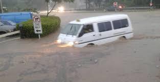
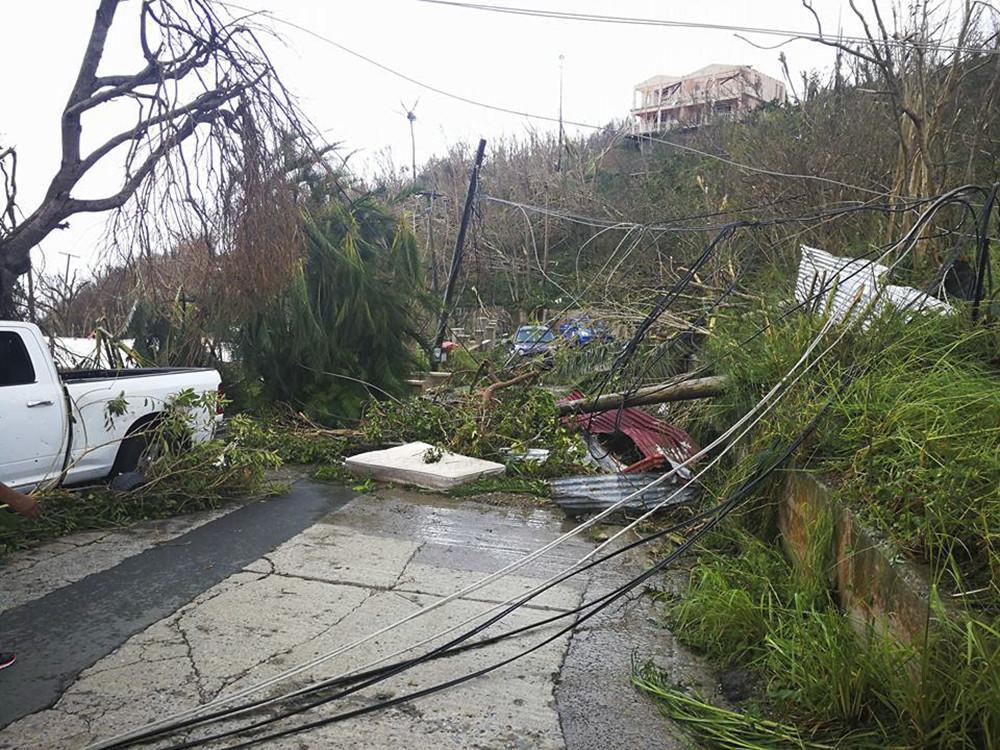
2 Summary The British Virgin Islands also known as Natures Little Secrets or the Sailing Capital of the world has been through a great deal this hurricane season. On August 7 th, Carnival Monday, everyone was on the road getting ready for the August Monday parade in the capital of Road Town, when the weather began to deteriorate rapidly around 1700Z (1 pm) with heavy downpour covering the entire territory from the afternoon into the next morning causing island wide flooding and landslides. It was forecasted that a tropical wave will generate some unstable weather conditions across the islands. That wave sat on the BVI for several hours while pouring out.

3 Delta Gas Station Purcell Estate

4 PURCELL ROAD GHUT

5 ROAD TOWN
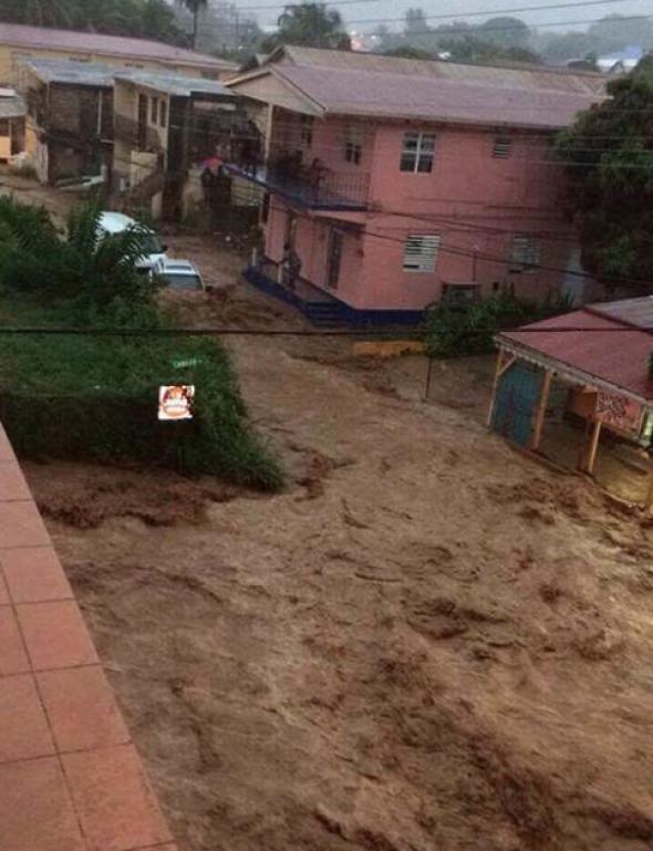
6 ROAD TOWN

7 PURCELL ESTATE

8 PURCELL ESTATE MAIN ROAD

9 JOES HILL OUT SKIRT OF TOWN
10 JOES HILL
11 ROAD TOWN

12 COUNTRY AREA

13 MCNAMARA
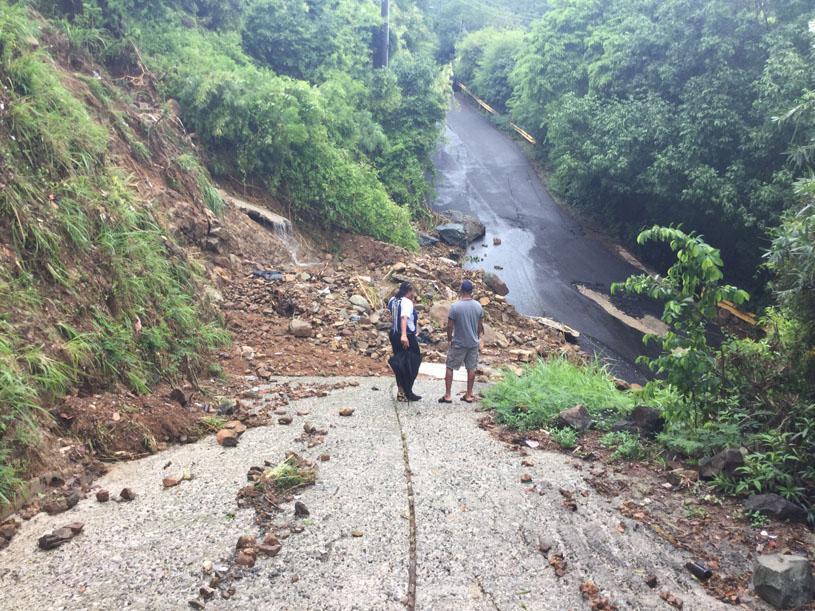
14 damages to roads and infrastructure from flooding and lightning vehicles washed down hill or down the drainage with the ghut flow damage to crops and livestock

15
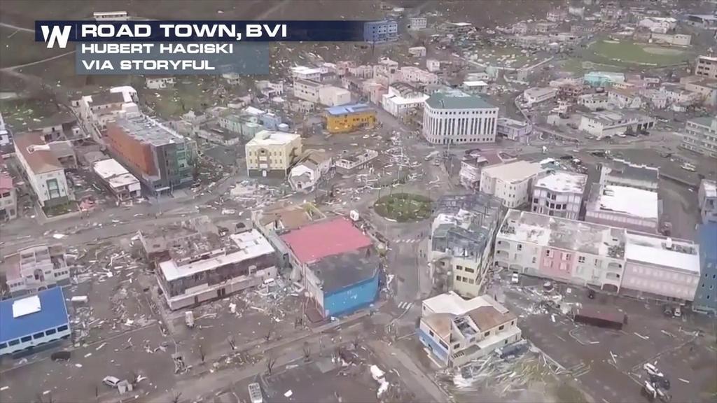
16 HELL HATH NO FURY LIKE A WOMAN SCORNED Exactly one month after the August flood the BVI was impacted severely by Hurricane Irma on the 6 th September. Embedded within hurricane Irma was several tornadoes. Irma forecasted winds were 185 mph, but Department of Disaster Management recorded winds of 234 throughout the ordeal which was the maximum that could be recorded for their weather instrument. Sir Richard Branson said that it was even higher on his island and it was way higher than a category 5, so i guess they have to go back to the drawing board and raise the categories.
17 Especially with this climate change we can expect more of this kind of weather or worst. Yachts that were anchored in the hurricane hole at Paraquita Bay ended up in Virgin Gorda or on other outer islands Vehicles from Tortola showed up on cliff on different islands Trailers heavily weighted with stocks lifted and turned up more than 40 feet from original position Planes taken out of hangars and put on top of buildings close to 100 feet away and other side of compound Yachts from Trellis Bay ended up in shallow lagoon just south of the airport
18 Equipment loss/damaged Stevenson screen Thermometers Automatic Weather Stations Generator UPS NDB Antennas

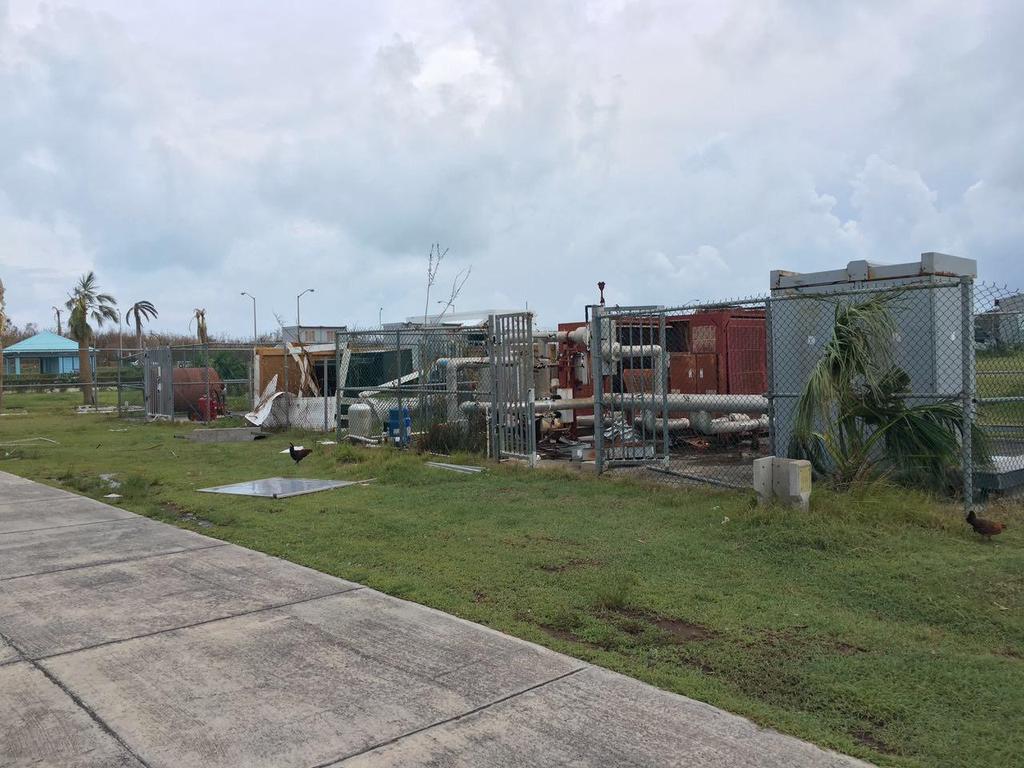
19 HURRICANE HOLE PARAQUITA BAY

20 HURRICANE HOLE

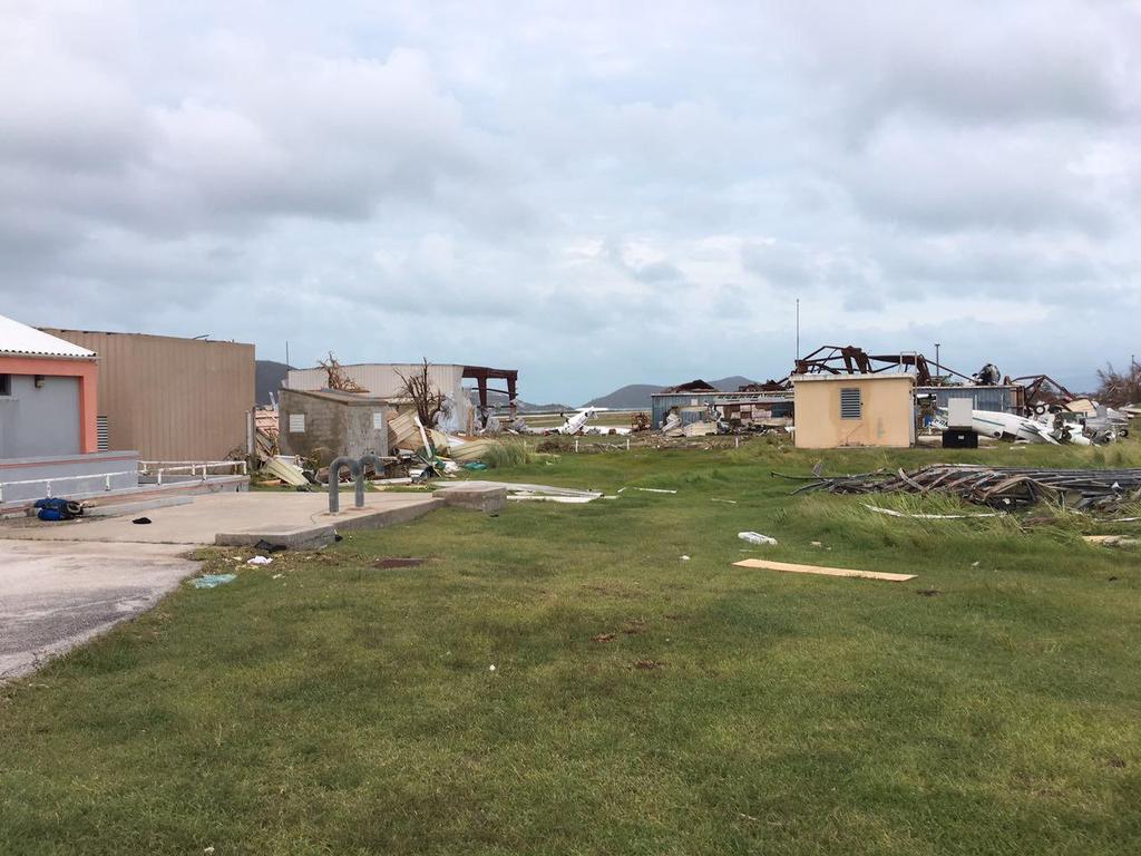
21 WATER FRONT DRIVE ROAD TOWN

22 SCOTIA BANK ROAD TOWN
23

24 TREASURE ISLE HOTEL
25 WEST END

26 AIRPORT ADMIN COMPLEX
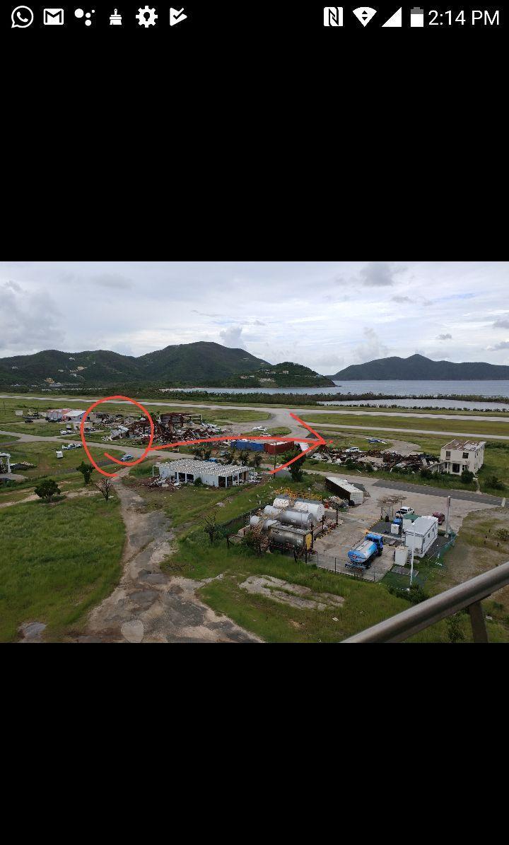
27

28 AIRPORT HANGARS
29 AIRPORT GENERATORS
30 AIRPORT

31 AIRPORT FIRE STATION

32 MAIN ROAD PARAQUITA BAY

33 GOVERNMENT ADMIN BUILDING

34 AIRCRAFT ON HANGAR

35 ELMORE STOUTT HIGH SCHOOL

36 MAIN ROAD PARAQUITA BAY
37 Damages Injured 125 Deaths 6 Estimated damage so far 3.6 billion USD Hotel 65 % of our hotels are completely damaged 25 % partially damaged and 10 % minor or no damage at all Yachting 85 % of industry totalled. Moorings Marina is expecting a shipment of 120 yachts to compliment their fleet. They should be partially ready for the upcoming tourist season.
38 Monthly Statistics June Total rainfall 57.4 mm or 2.26 inches Day with most rainfall was Saturday 10 th 38.6 mm or 1.52 inches Highest temperature 33 C or 91.4 F JULY Total rainfall mm or 7.6 inches Day with most rainfall was Thursday 13 th 97.0 mm or 3.8 inches Highest temperature 32 C or 89.6 F
39 Monthly Statistics Cont d AUGUST Total rainfall Day with most rainfall was Tuesday 8 th Highest temperature SEPTEMBER Total rainfall Day with most rainfall was Thursday 7 th Highest temperature mm or inches mm or inches 32 C or 89.6 F mm or inches mm or inches 34 C or 93.2 F
40 Monthly Statistics Cont d OCTOBER Total rainfall mm or 9.69 inches Day with most rainfall was Sunday 15 th 99.6 mm or 3.92 inches Highest temperature 31 C or 87.8 F NOVEMBER Total rainfall mm or 4.21 inches Day with most rainfall was Monday 6 th 47.6 mm or 1.85 inches Highest temperature 31 C OR 87.8 F

41 Rainfall June- November 2017 RAINFALL ACCUMULATION JUNE JULY AUGUST SEPTEMBER OCTOBER NOVEMBER
WEDNESDAY 30 TH AUGUST, :57 p.m. Tropical Storm Irma forms in the Atlantic. Don t let your guard down, always #Be Ready.
 Chapter 1 - The Set Up In the days leading up to Irma a series of composed and sobering text messages, presented in truncated form below, from Department of Disaster Management warned us of the pending
photo courtesy of
 BRITISH VIRGIN ISLANDS REPORT TROPICAL STORM JEANNE photo courtesy of www.bviplatinum.com PREPARED BY THE DEPARTMENT OF DISASTER MANAGEMENT 1 EVENT 13 th -16 th September, 2004 TROPICAL STORM JEANNE Sequence
The Impact of 2007 Atlantic Hurricane Season on Dominica
 The Impact of 2007 Atlantic Hurricane Season on Dominica DOMINICA November 2007 Main Activities Freak Twister on June 21st 2007. Hurricane Dean on August 16th to 17th 2007 Active Tropical Wave on September
WEATHER SYSTEMS IMPACTING THE CAYMAN ISLANDS Prepared by the staff of the Cayman Islands National Weather Service
 WEATHER SYSTEMS IMPACTING THE CAYMAN ISLANDS 2008 Prepared by the staff of the Cayman Islands National Weather Service TROPICAL STORM DOLLY Formed 194 miles west of Grand Cayman July 19 th. The tropical
Are You Ready For Hurricane Season? 2018 Hurricane Talk B Y : S T O R M T E A M 8 M E T E O R O L O G I S T J U L I E P H I L L I P S
 Are You Ready For Hurricane Season? 2018 Hurricane Talk B Y : S T O R M T E A M 8 M E T E O R O L O G I S T J U L I E P H I L L I P S About Me I am Currently a Weekday Meteorologist at WFLA Channel 8.
California OES Weather Threat Briefing
 California OES Weather Threat Briefing Wednesday, January 16, 2019 9:00 AM PST Day 1: Strong winds, heavy mountain snow and heavy rain with isolated thunderstorms across much of the state through Thursday
Marshall Alexander Forecaster Commonwealth of Dominica
 Marshall Alexander Forecaster Commonwealth of Dominica Dominica 2015 Impacts Tropical Storm Danny (August 24 th ) Tropical Storm Erika (August 27 th ) Tropical Storm Grace (Remnants) (September 10 th -11
Storm Surge Forecast with Shifting Forecast Tracks
 Storm Surge Forecast with Shifting Forecast Tracks Storm Surge Findings in the Florida Keys Jon Rizzo Warning Coordination Meteorologist National Weather Service Florida Keys Florida Keys Life History
SIGNIFICANT EVENTS Severe Storms November 1994 January 1996 August 1998 and May 2000 March 2002 May 2002 Champaign County
 SIGNIFICANT EVENTS Severe Storms November 1994 On Nov. 1, 1994, high winds gusted over 60 mph at times across the northwest third of Ohio. The highest measured wind gust was 63 mph at Columbus Grove (Putnam).
NOAA s National Weather Service Philadelphia/Mt. Holly NJ
 Next Briefing Package: Friday, October 2, 2015 no later than 300 PM Hazards and Impacts: Overview: A dangerous weather pattern still threatens our region. Threats include very heavy rainfall, inland river
Significant Flooding Expected
 Significant Flooding Expected Decision Support Briefing #5 As of: 9:00 AM September 14, 2018 What Has Changed? Flash Flood Watch now in effect for part of area, will be expanded later today 9/14/2018 9:23
TROPICAL STORM NATE BRIEFING
 TROPICAL STORM NATE BRIEFING 5:00 AM CDT Friday, October 6, 2017 Prepared by: NWS NWSNewOrleans www.weather.gov/neworleans Situation Overview No significant changes to the track forecast this morning.
Hurricane Harvey: SE Texas Impacts. 10 AM CDT UPDATE Saturday, August 26, 2017 Prepared by: Dan Reilly, Brian Kyle
 Hurricane Harvey: SE Texas Impacts 10 AM CDT UPDATE Saturday, August 26, 2017 Prepared by: Dan Reilly, Brian Kyle Latest Observations and Radar Hurricane Harvey centered near Victoria and weakening Wind
HURRICANE IRENE. CONFERENCE CALL BRIEFING SLIDES Saturday August 27, :30 AM
 HURRICANE IRENE CONFERENCE CALL BRIEFING SLIDES Saturday August 27, 2011 8:30 AM NHC TRACK AND CONE HURRICANE IRENE WATCHES/WARNINGS Hurricane Warning along south coast including all of Cape Cod and Islands
Hurricane Matthew Threats and Impacts Briefing for Eastern NC
 Hurricane Matthew Threats and Impacts Briefing for Eastern NC October 6 th, 2016 Date/Time Created: 10/6/2016, Noon EDT National Weather Service Newport/Morehead City, NC Hurricane Matthew Key Points Changes
IWT Scenario 1 Integrated Warning Team Workshop National Weather Service Albany, NY October 31, 2014
 Integrated Warning Team Workshop National Weather Service Albany, NY October 31, 2014 23 24 25 26 27 Scenario 1 Timeline November 23-27 Sun Mon Tue Wed Thu Thanksgiving Day Sunday, Nov. 23 @ 430 pm NWS
The Impacts of the 2008 Hurricane Season On Trinidad and Tobago
 Synoptic Branch Piarco International Airport Piarco, Trinidad Telephone: 669-4392 Fax: 669-4727 Email: synop@tstt.net.tt The Impacts of the 2008 Hurricane Season On Trinidad and Tobago The 2008 Atlantic
Hurricane Matthew. National Weather Service Wilmington NC. Steven Pfaff, WCM.
 Hurricane Matthew Threat Assessment for northeast South Carolina & southeast North Carolina National Weather Service Wilmington NC 730 AM EDT Tuesday October 4, 2016 Steven Pfaff, WCM Steven.Pfaff@noaa.gov
HURRICANE HARVEY COE Navigation BRIEFING
 HURRICANE HARVEY COE Navigation BRIEFING 10:00 AM CDT Friday, August 25, 2017 NWSNewOrleans www.weather.gov/neworleans Situation Overview New Information Harvey continues to strengthen Max sustained winds
Hurricane Matthew. Life Threatening Flash Flooding Likely. National Weather Service Wilmington NC. Josh Weiss, Meteorologist
 Hurricane Matthew Life Threatening Flash Flooding Likely Threat Assessment for northeast South Carolina & southeast North Carolina National Weather Service Wilmington NC 630 PM EDT Friday October 7, 2016
NOAA s National Weather Service Philadelphia/Mt. Holly NJ
 Next Briefing Package: Thursday, October 1, 2015 no later than 300 PM Hazards and Impacts: Overview: A dangerous weather pattern is developing for our region. Threats include very heavy rainfall, inland
MIAMI-SOUTH FLORIDA National Weather Service Forecast Office
 MIAMI-SOUTH FLORIDA National Weather Service Forecast Office http://www.weather.gov/miami June 2015 South Florida Weather Summary Dry East, Wet West...Drought Remains SE Florida July 3, 2015: Depending
Daily Operations Briefing. Sunday, October 22, :30 a.m. EDT
 Daily Operations Briefing Sunday, October 22, 2017 8:30 a.m. EDT Significant Activity Oct 21-22 Significant Events: Response and recovery Harvey, Irma, Maria; CA Wildfires Tropical Activity: Atlantic No
A HURRICANE IS COMING. Presented by Atiba Upchurch Broward Emergency Management Division
 A HURRICANE IS COMING Presented by Atiba Upchurch Broward Emergency Management Division Mission Statement To safeguard the lives and property of the people of Broward County from major hazards and emergencies
TROPICAL DEPRESSION HARVEY BRIEFING
 TROPICAL DEPRESSION HARVEY BRIEFING 10:15 PM CDT Wednesday, August 23, 2017 Prepared by: Lara Beal NWSCorpus www.weather.gov/corpuschristi Situation Overview No changes to Watches. Hurricane Watch remains
Hurricane Matthew. National Weather Service Wilmington NC. Steven Pfaff, WCM.
 Hurricane Matthew Threat Assessment for northeast South Carolina & southeast North Carolina National Weather Service Wilmington NC 515 PM EDT Monday October 3, 2016 Steven Pfaff, WCM Steven.Pfaff@noaa.gov
Satellite and Radar. 5:55 am Infrared Satellite with Surface Wind Arrows. 6:15 am Ruskin Doppler Radar. Large southerly wind field
 Satellite and Radar 5:55 am Infrared Satellite with Surface Wind Arrows 6:15 am Ruskin Doppler Radar Large southerly wind field Developing showers rotating onshore NHC Forecast Hurricane Warning Big Bend
History of Natural and Man-Made Disaster within the Region. There have been two aircraft accident resulting in casualties within the past 50 years.
 Aircraft Accidents Hail History of Natural and Man-Made Disaster within the Region There have been two aircraft accident resulting in casualties within the past 50 years. Date Number of Passengers Number
Major Hurricane Earl
 Major Hurricane Earl Advisory 33 North Carolina Threat Assessment Prepared at: 11 AM Thursday September 2, 2010 Hurricane and Tropical Storm Warnings in effect for the North Carolina Coast and Sounds NWS
Hydrologic Briefing Tropical Storm Harvey
 Hydrologic Briefing Tropical Storm Harvey 5:00 PM CDT Sunday, August 27, 2017 Prepared by: Jennifer Dunn/Christina Barron NWSCorpus www.weather.gov/corpuschristi Situation Overview Tropical Storm Harvey
Saturday, October 6, :30 a.m. EDT
 Saturday, October 6, 2018 8:30 a.m. EDT Significant Activity Oct 5-6 Significant Events: None Tropical Activity: Atlantic Tropical Storm Leslie; Disturbance 1 (High: 90%) Eastern Pacific Hurricane Sergio
TXWARN Tabletop Exercise: Hurricane Helen
 TXWARN Tabletop Exercise: Hurricane Helen July 31, 2015 Administrative Details In-studio participants and remote participants Situation manual Evaluations Training hours 1 In Studio: Welcome and Introductions
Major Hurricane Earl
 Major Hurricane Earl Advisory 32 North Carolina Threat Assessment Prepared at: 8 AM Thursday September 2, 2010 Hurricane and Tropical Storm Warnings in effect for the North Carolina Coast and Sounds. NWS
Tropical Activity. Atlantic Hurricane Florence (CAT 4)
") Tropical Activity Atlantic Hurricane Florence (CAT 4) Located 530 miles southeast of Cape Fear, NC Moving WNW at 17 mph; maximum sustained winds 130 mph Expected to slow down considerably by late Thursday
Tropical Activity Atlantic Hurricane Florence (CAT 4) Located 530 miles southeast of Cape Fear, NC Moving WNW at 17 mph; maximum sustained winds 130 mph Expected to slow down considerably by late Thursday
Daily Operations Briefing. Thursday, November 9, :30 a.m. EST
 Daily Operations Briefing Thursday, November 9, 2017 8:30 a.m. EST Significant Activity Nov 8-9 Significant Events: Tropical Cyclones Harvey, Irma, and Maria Tropical Activity: Atlantic Tropical Storm
Monday, October 8, :30 a.m. EDT
 Monday, October 8, 2018 8:30 a.m. EDT Significant Activity Oct 7-8 Significant Events: Tropical Storm Michael Preparation Tropical Activity: Atlantic Tropical Storm Leslie; Tropical Storm Michael; Disturbance
NWS HURRICANES June 3, 2015
 NWS HURRICANES June 3, 2015 Hurricane Season June 1 November 30 2 What s the concern? All tropical systems passing within 125nm of central Maryland since 1950 Mid-Atlantic Hurricanes Greatest Risk: August
Hurricane Matthew Life Threatening Flash Flooding Likely
 Hurricane Matthew Life Threatening Flash Flooding Likely Threat Assessment for northeast South Carolina & southeast North Carolina National Weather Service Wilmington NC 12 AM EDT Saturday October 8, 2016
Significant Coastal Storm Today through Thursday, 11/7-8. Weather Briefing
 Significant Coastal Storm Today through Thursday, 11/7-8 Weather Briefing Prepared 10:00 am EST Wednesday, November 7, 2012 Presented by Gary Conte, Warning Coordination Meteorologist NOAA s National Weather
The hydrologic service area (HSA) for this office covers Central Kentucky and South Central Indiana.
 for this office covers Central Kentucky and South Central Indiana.") January 2012 February 13, 2012 An X inside this box indicates that no flooding occurred within this hydrologic service area. January 2012 continued the string of wet months this winter. Rainfall was generally
January 2012 February 13, 2012 An X inside this box indicates that no flooding occurred within this hydrologic service area. January 2012 continued the string of wet months this winter. Rainfall was generally
Hydrologic Briefing Tropical Storm Harvey
 Hydrologic Briefing Tropical Storm Harvey 10:30 AM CDT Sunday, August 27, 2017 Prepared by: John Metz NWSCorpus www.weather.gov/corpuschristi Situation Overview Tropical Storm Harvey Harvey to remain a
Hurricane Irma. City of Cocoa Beach September 8 12, 2017
 Hurricane Irma City of Cocoa Beach September 8 12, 2017 Monitoring prior to landfall Expected effects What happened What went well What didn t go well Changes and improvements After Action Outline Storm
HURRICANE NATE BRIEFING
 HURRICANE NATE BRIEFING 2:00 PM CDT Saturday, October 07, 2017 Prepared by: NWS NWSNewOrleans www.weather.gov/neworleans Situation Overview continues to intensify. It is now forecast to be a category 2
ovember 2008 Antigua and Barbuda Meteorological Service
 ovember 2008 Antigua and Barbuda Meteorological Service The Atlantic Hurricane Season Summary 2008 Special Focus on Antigua and Barbuda The Season in Brief Sixteen (16) named storms formed in the Atlantic
TROPICAL STORM HARVEY BRIEFING
 TROPICAL STORM HARVEY BRIEFING 10:00 AM CDT Sunday, August 27, 2017 Prepared by: NWS LIX NWSNewOrleans www.weather.gov/neworleans Situation Overview New Information Tropical Storm Winds 40mph Immediate
Hurricane Harvey: SE Texas Impacts. 10 PM CDT UPDATE Friday, August 25, 2017 Prepared by: Lance Wood
 Hurricane Harvey: SE Texas Impacts 10 PM CDT UPDATE Friday, August 25, 2017 Prepared by: Lance Wood Latest Observations Hurricane Harvey making landfall this evening near Rockport as a category 4 hurricane.
Hurricane Sandy October 28 th 31 st 2012
 Hurricane Sandy October 28 th 31 st 2012 Prepared 530 PM EDT Saturday October 27, 2012 Gary Szatkowski NOAA s NJ Forecast Office Weather.gov/phi Purpose of Briefing Briefing #7 for event Promote situational
TROPICAL STORM NATE BRIEFING
 TROPICAL STORM NATE BRIEFING 2:00 PM CDT Friday, October 06, 2017 Prepared by: NWS NWSNewOrleans www.weather.gov/neworleans Situation Overview Track forecast has not changed since the 10 am advisory. Hurricane
Daily Operations Briefing. Wednesday, November 8, :30 a.m. EST
 Daily Operations Briefing Wednesday, November 8, 2017 8:30 a.m. EST Significant Activity Nov 7-8 Significant Events: Tropical Cyclones Harvey, Irma, and Maria Tropical Activity: Atlantic Tropical Storm
Advisory #35 Briefing 630 PM EDT Thursday October 06, 2016
 Advisory #35 Briefing 630 PM EDT Thursday October 06, 2016 Disclaimer: The information contained within this briefing is time-sensitive, do not use beyond 6 hours after the issuance Next Webinar Update:
Major Hurricane Matthew Briefing Situation Overview
 Major Hurricane Matthew Briefing Situation Overview At 5 p.m. Tuesday, Category 4 Hurricane Matthew was about 860 miles South-Southeast of Mayport, Florida, moving north around 10 mph. Maximum sustained
Tropical Cyclone Joaquin (AL112015)
") Tropical Cyclone Joaquin (AL112015) Wind and Storm Surge Event Briefing 9 October 2015 Vito Alessio Robles No.179. Col. Hda Gpe Chimalistac. Del. Álvaro Obregón. Cp 01050, México D.F. Tel: +52 (55) 5616-8161,
Tropical Cyclone Joaquin (AL112015) Wind and Storm Surge Event Briefing 9 October 2015 Vito Alessio Robles No.179. Col. Hda Gpe Chimalistac. Del. Álvaro Obregón. Cp 01050, México D.F. Tel: +52 (55) 5616-8161,
Tropical Update. 5 PM EDT Sunday, September 10, 2017 Hurricane Irma, Hurricane Jose, Tropical Wave (60%)
") Tropical Update 5 PM EDT Sunday, September 10, 2017 Hurricane Irma, Hurricane Jose, Tropical Wave (60%) This update is intended for government and emergency response officials, and is provided for informational
Tropical Update 5 PM EDT Sunday, September 10, 2017 Hurricane Irma, Hurricane Jose, Tropical Wave (60%) This update is intended for government and emergency response officials, and is provided for informational
SITUATION REPORT #7 September 8 th, 2017
 MCO AIRPORT EMERGENCY OPERATIONS CENTER SITUATION REPORT #7 September 8 th, 2017 STATE OF FLORIDA REGION V FEMA REGION IV GENERAL INFORMATION Local State of Emergency Declaration Number: 17-235 Dated:
Canes on Canes: Keeping South Florida Prepared During the Calm Before the Storm. Matt Onderlinde and Pete Finocchio
 Canes on Canes: Keeping South Florida Prepared During the Calm Before the Storm Matt Onderlinde and Pete Finocchio Outline The Science of Hurricanes Why and When South Floridians Must Be Weather-Ready
Hurricane Harvey and What is to come. Eric Berger, Space City Weather
 Hurricane Harvey and What is to come Eric Berger, Space City Weather Today s talk A word about Space City Weather Social media-rology A look back at Hurricane Harvey Why does Houston get these storms Rainfall
TROPICAL STORM NATE BRIEFING
 TROPICAL STORM NATE BRIEFING 10:30 AM CDT Friday, October 06, 2017 Prepared by: NWS NWSNewOrleans www.weather.gov/neworleans Situation Overview Track forecast has shifted slightly eastward. Hurricane Watch
LECTURE #15: Thunderstorms & Lightning Hazards
 GEOL 0820 Ramsey Natural Disasters Spring, 2018 LECTURE #15: Thunderstorms & Lightning Hazards Date: 1 March 2018 (lecturer: Dr. Shawn Wright) I. Severe Weather Hazards focus for next few weeks o somewhat
Chapter 3: Weather Fronts & Storms
 Chapter 3: Weather Fronts & Storms An AIR MASS is a large body of air that has similar characteristics (temperature, humidity) throughout. Air masses can be massively large. Air masses are classified by
IWT Scenario 2 Integrated Warning Team Workshop National Weather Service Albany, NY October 31, 2014
 IWT Scenario 2 Integrated Warning Team Workshop National Weather Service Albany, NY October 31, 2014 09 10 11 12 13 Scenario 2 Timeline December 9-13 Tue Wed Thu Fri Sat Tue, Dec. 9 @ 5 am 2014 2014 2014
Champaign-Urbana 1998 Annual Weather Summary
 Champaign-Urbana 1998 Annual Weather Summary ILLINOIS STATE WATER SURVEY Audrey Bryan, Weather Observer 2204 Griffith Dr. Champaign, IL 61820 wxobsrvr@sparc.sws.uiuc.edu The development of the El Nìno
Monday, October 19, CDT Brian Hoeth
 Monday, October 19, 2015 1400 CDT Brian Hoeth Some of the briefing presented is worstcase scenario and may differ in detail from local NWS Weather Forecast Offices. National Weather Service Southern Region
An upper to mid level circulation (Low) in the NW Caribbean is
 in the NW Caribbean is") WEEKLY WEATHER OUTLOOK BELIZE, CENTRAL AMERICA PERIOD: Monday-Monday, Oct. 1 October 8, 2012 DATE ISSUED: Monday, Oct 1, 2012 6:00 am RFrutos EcoSolutions & Services SYNOPSIS: An upper to mid level circulation
WEEKLY WEATHER OUTLOOK BELIZE, CENTRAL AMERICA PERIOD: Monday-Monday, Oct. 1 October 8, 2012 DATE ISSUED: Monday, Oct 1, 2012 6:00 am RFrutos EcoSolutions & Services SYNOPSIS: An upper to mid level circulation
HURRICANE IRMA. 12 PM ET Saturday, September Prepared by: Kyle Thiem / Sid King.
 HURRICANE IRMA 12 PM ET Saturday, September 9 2017 Prepared by: Kyle Thiem / Sid King www.weather.gov/atlanta/briefings @NWSAtlanta www.weather.gov/atlanta Situation Overview 11:00 AM EDT Sat Sep 9 Location:
Hurricanes. Environmental Geology Mr. Paul Lowrey. Stacey Singleton, Cassandra Combs, Dwight Stephenson, Matt Smithyman
 Environmental Geology Mr. Paul Lowrey Stacey Singleton, Cassandra Combs, Dwight Stephenson, Matt Smithyman Hurricanes EMPACTS Project, Spring 2017 Northwest Arkansas Community College, Bentonville, AR
Tropical Cyclone Isaac (AL092012)
") Tropical Cyclone Isaac (AL092012) Event Briefing, Central Caribbean Impacts Caribbean Risk Managers Ltd Facility Supervisor 27 August 2012 Facility Supervisor: Caribbean Risk Managers Ltd Email: ccrif@ccrif.org
Tropical Cyclone Isaac (AL092012) Event Briefing, Central Caribbean Impacts Caribbean Risk Managers Ltd Facility Supervisor 27 August 2012 Facility Supervisor: Caribbean Risk Managers Ltd Email: ccrif@ccrif.org
Daily Operations Briefing. Tuesday, October 24, :30 a.m. EDT
 Daily Operations Briefing Tuesday, October 24, 2017 8:30 a.m. EDT Significant Activity Oct 23-24 Significant Events: Response and recovery Tropical Cyclones Harvey, Irma, Maria Tropical Activity: Atlantic
TROPICAL STORM HARVEY BRIEFING
 TROPICAL STORM HARVEY BRIEFING 1 PM CDT Saturday, August 26, 2017 Prepared by: John Metz NWSCorpus www.weather.gov/corpuschristi Overview Life-threatening conditions continue. Storm Surge Warnings remain
Wind field has expanded and is very large. Hurricane Wind field = 100 miles wide, Tropical Storm Wind field = 360 miles wide
 HURRICANE IRMA 12 PM ET Sunday, September 10 2017 Prepared by: Keith Stellman / Kyle Thiem www.weather.gov/atlanta/briefings @NWSAtlanta www.weather.gov/atlanta Situation Overview 11:10 AM EDT Sun Sep
Severe Weather. Copyright 2006 InstructorWeb
 Severe Weather People need to know what the weather is going to do. Sometimes severe weather can happen. Severe weather can cause property damage, injuries to people and animals, and even loss of life.
NEW ZEALAND WEATHER. BRIEF REVIEW OF WINTER AND SPRING 1990 WINTER 1990 (Fig. 1) Weather and Climate (1991) 11: 31-36
 Weather and Climate (1991) 11: 31-36") Weather and Climate (1991) 11: 31-36 31 NEW ZEALAND WEATHER BRIEF REVIEW OF WINTER AND SPRING 1990 WINTER 1990 (Fig. 1) Winter 1990 was very dry in the far south. Northeasterlies brought sunny conditions
Weather and Climate (1991) 11: 31-36 31 NEW ZEALAND WEATHER BRIEF REVIEW OF WINTER AND SPRING 1990 WINTER 1990 (Fig. 1) Winter 1990 was very dry in the far south. Northeasterlies brought sunny conditions
Tropical Update. 5 AM EDT Tuesday, September 12, 2017 Post-Tropical Cyclone Irma, Hurricane Jose, & Tropical Wave (10%)
") Tropical Update 5 AM EDT Tuesday, September 12, 2017 Post-Tropical Cyclone Irma, Hurricane Jose, & Tropical Wave (10%) This update is intended for government and emergency response officials, and is provided
Tropical Update 5 AM EDT Tuesday, September 12, 2017 Post-Tropical Cyclone Irma, Hurricane Jose, & Tropical Wave (10%) This update is intended for government and emergency response officials, and is provided
Tropical Update. 5 PM EDT Thursday, September 7, 2017 Hurricane Irma, Hurricane Jose, and Hurricane Katia
 Tropical Update 5 PM EDT Thursday, September 7, 2017 Hurricane Irma, Hurricane Jose, and Hurricane Katia This update is intended for government and emergency response officials, and is provided for informational
Weather forecasts and warnings: Support for Impact based decision making
 Weather forecasts and warnings: Support for Impact based decision making Gerry Murphy, Met Éireann www.met.ie An Era of Change Climate and weather is changing Societal vulnerability is increasing The nature
Daily Operations Briefing. Thursday, October 26, :30 a.m. EDT
 Daily Operations Briefing Thursday, October 26, 2017 8:30 a.m. EDT Significant Activity Oct 25-26 Significant Events: Response and recovery Tropical Cyclones Harvey, Irma and Maria Tropical Activity: Atlantic
Ensuring the Building of Community Resiliency through Effective Partnership December 4, 2017 Melia Nassau Beach Valentino A. Hanna
 Ensuring the Building of Community Resiliency through Effective Partnership December 4, 2017 Melia Nassau Beach Valentino A. Hanna Sol Caribbean Presence What Occurred Mega Storms 2017 Cat 5 Hurricane
Recent development of the National Hydro-Meteorological Service (NHMS) of Viet Nam for disaster risk reduction
 of Viet Nam for disaster risk reduction") Ministry of Natural Resources and Environment National Hydro-Meteorological Service Recent development of the National Hydro-Meteorological Service (NHMS) of Viet Nam for disaster risk reduction Tran Van
Ministry of Natural Resources and Environment National Hydro-Meteorological Service Recent development of the National Hydro-Meteorological Service (NHMS) of Viet Nam for disaster risk reduction Tran Van
TROPICAL STORM HARVEY COE Navigation Call - Update
 TROPICAL STORM HARVEY COE Navigation Call - Update 10:00 AM CDT Tuesday, August 29, 2017 Prepared by: NWS LIX NWSNewOrleans www.weather.gov/neworleans Situation Overview New Information Drifting ENE at
CASE STUDY: Clermont Floods, 1916
 CASE STUDY: Clermont Floods, 1916 By Mr Jeff Callaghan The early location of Clermont was particularly prone to destructive flooding. This was due to Clermont's location on a flood plain between a lagoon
Table 1. August average temperatures and departures from normal ( F) for selected cities.
 for selected cities.") Climate Summary for Florida August 2016 Prepared by Lydia Stefanova and David Zierden Florida Climate Center, The Florida State University, Tallahassee, Florida Online at: http://climatecenter.fsu.edu/products-services/summaries
Climate Summary for Florida August 2016 Prepared by Lydia Stefanova and David Zierden Florida Climate Center, The Florida State University, Tallahassee, Florida Online at: http://climatecenter.fsu.edu/products-services/summaries
Severe Weather Potential for Southeast Texas
 Severe Weather Potential for Southeast Texas Dan Reilly, Kent Prochazka, Scott Overpeck National Weather Service Houston/Galveston 10 am Synopsis Storm to likely bring severe weather to Southeast Texas
Ecological Context - Urban settlements are part of their surrounding ecosystem. Austin
 Ecological Context - Urban settlements are part of their surrounding ecosystem Austin Ecotone Division between West and East Flyway Uplift River Balcones Escarpment Central Texas Climate The principal
Three main areas of work:
 Task 2: Climate Information 1 Task 2: Climate Information Three main areas of work: Collect historical and projected weather and climate data Conduct storm surge and wave modeling, sea-level rise (SLR)
CASE STUDY: Tropical Cyclone Monica, April 2006
 CASE STUDY: Tropical Cyclone Monica, April 2006 By Mr Jeff Callaghan Retired Senior Severe Weather Forecaster, Bureau of Meteorology, Brisbane The track of tropical cyclone Monica (Figure 1) took it from
Daily Operations Briefing. Sunday, October 29, :30 a.m. EDT
 Daily Operations Briefing Sunday, October 29, 2017 8:30 a.m. EDT Significant Activity Oct 28-29 Significant Events: Response and Recovery Tropical Cyclones Harvey, Irma, and Maria Tropical Activity: Atlantic
The Pennsylvania Observer
 The Pennsylvania Observer September 3, 2008 Summer 2008 Weather Summary Written by: Brian Thompson The opening days of June started dry, but a warm front brought a widespread rain a couple of days into
Weather briefing Strong Coastal Nor easter November 7 th -8 th, 2012
 Weather briefing Strong Coastal Nor easter November 7 th -8 th, 2012 Prepared 1245 PM EDT Tuesday November 6, 2012 Gary Szatkowski NOAA s NJ Forecast Office Weather.gov/phi Purpose of Briefing Briefing
Your Task: Read each slide then use the underlined red or underlined information to fill in your organizer.
 Severe Weather: Tornadoes and Hurricanes Thunderstorms and Lightning S6E4 d. Construct an explanation of the relationship between air pressure, weather fronts, and air masses and meteorological events
Thursday, March 7, :30 a.m. EST
 Thursday, March 7, 2019 8:30 a.m. EST Significant Activity Mar 6-7 Significant Events: Severe thunderstorms and tornadoes AL and GA (FINAL) Tropical Activity: No activity affecting U.S. interests Significant
Daily Operations Briefing Wednesday, April 5, :30 a.m. EDT
 Daily Operations Briefing Wednesday, April 5, 2017 8:30 a.m. EDT Significant Activity Apr 4-5 Significant Events: Severe Weather Southern Plains to Southeast Significant Weather: Severe thunderstorms &
FLOODING. Flood any relatively high stream flow overtopping the natural or artificial banks in a water system.
 CATASTROPHIC EVENTS FLOODING Flood any relatively high stream flow overtopping the natural or artificial banks in a water system. Common Causes: Long-lasting rainfall over a broad area Locally intense
Daily Operations Briefing. Tuesday, November 7, :30 a.m. EST
 Daily Operations Briefing Tuesday, November 7, 2017 8:30 a.m. EST Significant Activity Nov 6-7 Significant Events: Tropical Cyclones Harvey, Irma, and Maria Tropical Activity: Atlantic Tropical Storm Rina
Tropical Storm Harvey: SE Texas Impacts
 Tropical Storm Harvey: SE Texas Impacts 10 AM CDT UPDATE Thursday, August 24, 2017 Prepared by: Dan Reilly, Brian Kyle PLEASE MUTE YOUR LINES AND DON T PUT ON HOLD! Situation Overview Tropical Storm Harvey
Weather Briefing. Coastal Storm Monday-Wednesday Dec 8-10, National Weather Service. Prepared 12/8/14 6:30 AM
 Weather Briefing Coastal Storm Monday-Wednesday Dec 8-10, 2014 National Weather Service http://www.weather.gov/nyc Prepared 12/8/14 6:30 AM Overview of Potential Hazards A strong low pressure system will
CASE STUDY: Severe Thunder Storms and Bucca Tornado, 29 th November 1992
 CASE STUDY: Severe Thunder Storms and Bucca Tornado, 29 th November 1992 By Mr Jeff Callaghan Retired Senior Severe Weather Forecaster, Bureau of Meteorology, Brisbane This was a notable severe thunderstorm
Tropical Update. 5 PM EDT Tuesday, September 5, 2017 Hurricane Irma, Tropical Storm Jose, and Tropical Depression Thirteen
 Tropical Update 5 PM EDT Tuesday, September 5, 2017 Hurricane Irma, Tropical Storm Jose, and Tropical Depression Thirteen This update is intended for government and emergency response officials, and is
ARUBA CLIMATOLOGICAL SUMMARY 2017 PRECIPITATION
 ARUBA CLIMATOLOGICAL SUMMARY 2017 PRECIPITATION The total amount of rainfall recorded at Reina Beatrix International Airport for the year 2017 was 391.0 mm. This is 17.1 % below normal ( Figure 1 ). During
Daily Operations Briefing. Thursday, September 21, :30 a.m. EDT
 Daily Operations Briefing Thursday, September 21, 2017 8:30 a.m. EDT Significant Activity Sep 20-21 Significant Events: Response for Hurricane Maria Tropical Activity: Atlantic Tropical Storm Jose; Hurricane
Daily Operations Briefing. Monday, October 30, :30 a.m. EDT
 Daily Operations Briefing Monday, October 30, 2017 8:30 a.m. EDT Significant Activity Oct 28-30 Significant Events: Response and Recovery Tropical Cyclones Harvey, Irma, and Maria Severe Weather Northeast
TROPICAL CYCLONE TORNADOES
 TROPICAL CYCLONE TORNADOES 2018 GOVERNOR S HURRICANE CONFERENCE TUESDAY, MAY 15, 2018 WILL ULRICH NWS FORECAST OFFICE MELBOURNE WHERE ARE THE TORNADOES? WHERE ARE THE TORNADOES? C B A WEST MELBOURNE, FL