Recent Developments in Tsunami R&D and Forecast Systems
|
|
|
- Jeffery Hutchinson
- 5 years ago
- Views:
Transcription

1 Recent Developments in Tsunami R&D and Forecast Systems Christian Meinig NOAA/PMEL Director of Engineering Oct 15, 2007
2 Outline DART array update Forecast System update-examples examples Deployment Results Tsunami R&D

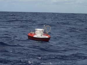
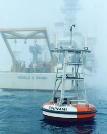
3 Global DARTs ~38 systems, 5 countries
4 Tsunami Forecasts Pre-operational stage Four successful realtime forecast over the past 18 months Testing and UI evaluations at warning centers

5

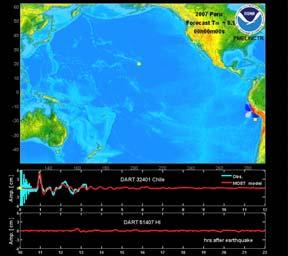
6 DART & MOST forecast Model comparison from Sumatra Sept 12 EQ Liujuan Tang NCTR, NOAA/PMEL

7 Warning center Example: Timeline of a Tsunami Event From Y. Wei, et al.,2007
8 DART Data Greatly Improves Forecast Without DART tide gage MOST (seismic data only) amplitude hours after earthquake (06:43:07 UTC, November 17, 2003) With DART tide gage MOST (tsunameter-adjusted) amplitude hours after earthquake (06:43:07 UTC, November 17, 2003)

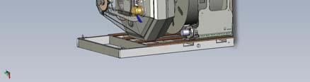
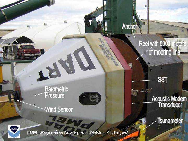
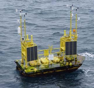
9 Next Generation DART TM Technology Desired improvements from DART TM Eliminate need for large ship & skilled crew Deployment sea state limitations Large buoys Vandalism protection Flexibility to array operations Cheaper lifecycle costs II
10 DART TM system evolution 20 years of tsunami research (early 80 s) Internally recording instruments (mid s) One-direction realtime reporting (DART I) (mid s) Transitioned to operations Bi-directional, global reporting (DART TM II) (2003) Patent pending & transitioned to operations (2006) Concept copied/adopted by commercial vendors (2006) Trademark filed/license applications Bi-directional, global, easy to deploy R&D (DART TM -ETD) (2007) SAIC licenses DART II technology ETD Pre-operational prototypes deployed
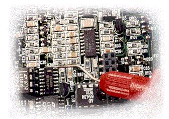
11 DART TM DART II & DART TM ETD Common core components-different packaging i.e. desktop and laptop No Changes: Data logger CPU, Acoustic Modem PCB, BPR, Paros, Iridium Modem and transmission protocol, system modes and tsunami detection scheme. Minor Changes: Acoustic modem transducer and pre-amp, system software and GPS & ground plane.
12 Infrastructure-unchanged NDBC
13


14 Packaging & Logistics

15 DART II-ETD New Features: 4-55 year expendable BPR Conex packaging MET sensors Improved upper mooring line Ongoing rigorous testing

16 DART-ETDs (Low Latitude)
17 102 Sea Height DART II-ETD Primary 98% Secondary 98% month test deployment Sea Height (m) Dec Jan Feb-07 6-Apr May Jun-07 4-Aug-07 Time (GMT) 102 Sea Height
18 DART II-ETD 103 Primary 99% Secondary 98% On-going ~7 month test deployment Sea Height Sea height (m) Mar-07 9-Apr Apr May-07 8-Jun Jun Jul-07 7-Aug-07 Time (GMT) 103 Sea Height

19 DART-ETD (High Latitude)
20 105/6 Line Tension and Sea Height Line Tension (lbs) Sea Height (m) Jul Jul Jul Jul Jul-07 4-Aug-07 9-Aug Aug Aug Aug Aug-07 Time (GMT) 105/6 Line Tension 105/6 Sea Height
 indicate that a fully deployed array of 39 ETD")
21 PMEL Cost Study Analysis. The findings (largely based on the cost differentials in unit production, unit service life, and the mode of deployment and type of vessels utilized) indicate that a fully deployed array of 39 ETD DART-II sites could be accomplished on sufficient service cycle for an annual budget of approximately $2.97M, or less than 22% of the projected budget for comparable array maintenance with Standard DART-II moorings...


22 4 th Generation DART?: A system with the power of human intelligence, vision capabilities, integrated audible alarm and very low battery requirements
23 Acknowledgements Vasily Titov, Scott Stalin, Dirk Tagawa, Michael Strick, Michael Spillane, Marie Eble, Rachel Tang, Angie Venturato, Yong Wei

24 Thank you For more information
GAMINGRE 8/1/ of 7
 FYE 09/30/92 JULY 92 0.00 254,550.00 0.00 0 0 0 0 0 0 0 0 0 254,550.00 0.00 0.00 0.00 0.00 254,550.00 AUG 10,616,710.31 5,299.95 845,656.83 84,565.68 61,084.86 23,480.82 339,734.73 135,893.89 67,946.95
The ITSU System in the Pacific Region and Future Upgrades
 The ITSU System in the Pacific Region and Future Upgrades Eddie Bernard Director, Pacific Marine Environmental Laboratory (PMEL) NOAA/USA Pacific Tsunami Warning Center OPERATIONAL ACTIVITIES SEISMIC DATA
Breakthrough underwater technology holds promise for improved local tsunami warnings
 Breakthrough underwater technology holds promise for improved local tsunami warnings J. Paros 1, E. Bernard 2, J. Delaney 3, C. Meinig 2, M. Spillane 2, P. Migliacio 1, L. Tang 2, W. Chadwick 4, T. Schaad
arxiv: v1 [physics.geo-ph] 31 Dec 2013
![arxiv: v1 [physics.geo-ph] 31 Dec 2013](/thumbs/95/125064092.jpg "arxiv: v1 [physics.geo-ph] 31 Dec 2013") Comparing the Nano-Resolution Depth Sensor to the Co-located Ocean Bottom Seismometer at MARS Elena Tolkova 1, Theo Schaad 2 1 NorthWest Research Associates 2 Paroscientific, Inc., and Quartz Seismic Sensors,
Comparing the Nano-Resolution Depth Sensor to the Co-located Ocean Bottom Seismometer at MARS Elena Tolkova 1, Theo Schaad 2 1 NorthWest Research Associates 2 Paroscientific, Inc., and Quartz Seismic Sensors,
Scarborough Tide Gauge
 Tide Gauge Location OS: 504898E 488622N WGS84: Latitude: 54 16' 56.990"N Longitude: 00 23' 25.0279"W Instrument Valeport 740 (Druck Pressure Transducer) Benchmarks Benchmark Description TGBM = 4.18m above
Notes on Comparing the Nano-Resolution Depth Sensor to the Co-located Ocean Bottom Seismometer at MARS
 Notes on Comparing the Nano-Resolution Depth Sensor to the Co-located Ocean Bottom Seismometer at MARS Elena Tolkova, Theo Schaad 1 1 Paroscientific, Inc., and Quartz Seismic Sensors, Inc. October 15,
SOP of PTWC as a Regional Tsunami Service Provider
 UNESCO IOC CTIC US NOAA ITIC Regional Training Workshop on Strengthening Tsunami Warning and Emergency Response Standard Operating Procedures and the Development of the ICG/CARIBE-EWS PTWC New Enhanced
Real-time experimental forecast of the Peruvian tsunami of August 2007 for U.S. coastlines
 GEOPHYSICAL RESEARCH LETTERS, VOL. 35, L04609, doi:10.1029/2007gl032250, 2008 Real-time experimental forecast of the Peruvian tsunami of August 2007 for U.S. coastlines Yong Wei, 1,2 Eddie N. Bernard,
Australian National Report to DBCP. DBCP October, 2014 Weihai, China
 Australian National Report to DBCP DBCP-30 27-31 October, 2014 Weihai, China Outline Australian Bureau of Meteorology (ABOM) Drifting Buoys Background & Planning 2013/14 Deployments & Current Status 2014/15
Linkage to the National Program
 Linkage to the National Program Frank González Pacific Marine Environmental Laboratory Seattle, WA Frank González, NOAA TIME Center, PMEL, Seattle, WA NOAA is about FORECASTS and WARNINGS -Hurricanes Sunspots
Establishment and Operation of a Regional Tsunami Warning Centre
 Establishment and Operation of a Regional Tsunami Warning Centre Dr. Charles McCreery, Director NOAA Richard H. Hagemeyer Pacific Tsunami Warning Center Ewa Beach, Hawaii USA Why A Regional Tsunami Warning
Location. Datum. Survey. information. Etrometa. Step Gauge. Description. relative to Herne Bay is -2.72m. The site new level.
 Tide Gauge Location OS: 616895E 169377N WGS84: Latitude: 51 o 22.919196 N Longitude: 01 o 6.9335907 E Instrument Type Etrometa Step Gauge Benchmarks Benchmark TGBM = 5.524m above Ordnance Datum Newlyn
Life Cycle of Convective Systems over Western Colombia
 Life Cycle of Convective Systems over Western Colombia Meiry Sakamoto Uiversidade de São Paulo, São Paulo, Brazil Colombia Life Cycle of Convective Systems over Western Colombia Convective System (CS)
Jackson County 2013 Weather Data
 Jackson County 2013 Weather Data 61 Years of Weather Data Recorded at the UF/IFAS Marianna North Florida Research and Education Center Doug Mayo Jackson County Extension Director 1952-2008 Rainfall Data
Hazard assessment based on radar-based rainfall nowcasts at European scale The HAREN project
 Hazard assessment based on radar-based rainfall nowcasts at European scale The HAREN project Marc Berenguer, Daniel Sempere-Torres 3 OPERA radar mosaic OPERA radar mosaic: 213919 133 Precipitation observations
Annual Average NYMEX Strip Comparison 7/03/2017
 Annual Average NYMEX Strip Comparison 7/03/2017 To Year to Year Oil Price Deck ($/bbl) change Year change 7/3/2017 6/1/2017 5/1/2017 4/3/2017 3/1/2017 2/1/2017-2.7% 2017 Average -10.4% 47.52 48.84 49.58
ANNOUNCEMENT WMO/ESCAP PANEL ON TROPICAL CYCLONES THIRTY-EIGHTH SESSION NEW DELHI, INDIA
 WMO IMD ESCAP ANNOUNCEMENT THIRTY-EIGHTH SESSION NEW DELHI, INDIA (21-25 February 2011) HISTORICAL BACKGROUND The tropical cyclones are particularly severe in the north Indian Ocean region. The northern
Lessons Learned from Past Tsunamis Warning and Emergency Response
 UNESCO IOC CTIC US NOAA ITIC Regional Training Workshop on Strengthening Tsunami Warning and Emergency Response Standard Operating Procedures and the Development of the ICG/CARIBE-EWS PTWC New Enhanced
Stream Discharge and the Water Budget
 Regents Earth Science Unit 6: Water Cycle & Climate Name: Lab # Stream Discharge and the Water Budget Introduction: The United States Geological Survey (USGS) measures and publishes values for the daily
Long Term Autonomous Ocean Remote Sensing Utilizing the Wave Glider
 Long Term Autonomous Ocean Remote Sensing Utilizing the Wave Glider J. Griffith, K. VanderLugt, Matt Cosad Liquid Robotics 1329 Moffett Park Drive Sunnyvale, CA 94089 Abstract Rising costs of ship time
Record date Payment date PID element Non-PID element. 08 Sep Oct p p. 01 Dec Jan p 9.85p
 2017/18 Record date Payment date PID element Non-PID element 08 Sep 17 06 Oct 17 9.85p - 9.85p 01 Dec 17 05 Jan 18-9.85p 9.85p 09 Mar 18 06 Apr 18 9.85p - 9.85p Final 22 Jun 18 27 Jul 18 14.65p - 14.65p
Operational Performance of the Second Generation Deep-ocean Assessment and Reporting of Tsunamis (DART II)
") Operational Performance of the Second Generation Deep-ocean Assessment and Reporting of Tsunamis (DART II) Richard Bouchard, Shannon McArthur, William Hansen, Kevin J. Kern, and Lea Locke NOAA s National
Operational Performance of the Second Generation Deep-ocean Assessment and Reporting of Tsunamis (DART II) Richard Bouchard, Shannon McArthur, William Hansen, Kevin J. Kern, and Lea Locke NOAA s National
Tsunami Response and the Enhance PTWC Alerts
 Tsunami Response and the Enhance PTWC Alerts Ken Gledhill GeoNet Project Director Chair, Intergovernmental Coordination Group, Pacific Tsunami Warning and Mitigation System (PTWS) Overview 1. Procedures
WHEN IS IT EVER GOING TO RAIN? Table of Average Annual Rainfall and Rainfall For Selected Arizona Cities
 WHEN IS IT EVER GOING TO RAIN? Table of Average Annual Rainfall and 2001-2002 Rainfall For Selected Arizona Cities Phoenix Tucson Flagstaff Avg. 2001-2002 Avg. 2001-2002 Avg. 2001-2002 October 0.7 0.0
Real-Time NO 3 and PO 4 Sensors for Chesapeake Bay
 Real-Time NO 3 and PO 4 Sensors for Chesapeake Bay Lora Harris Jeremy Testa Amanda Moore UMCES Chesapeake Biological Laboratory Mark Trice Rebecca Burrell Kristin Heyer John Zimmerelli Bruce Michael Ben
ESURFMAR Report to DBCP
 ESURFMAR Report to DBCP by Jean Rolland, Pierre Blouch, Michel Trémant DBCP 23 -Jeju 15-19 October ESURFMAR E-SURFMAR is an optional programme of the ground based EUMETNET Composite Observing System (EUCOS)
Winter Season Resource Adequacy Analysis Status Report
 Winter Season Resource Adequacy Analysis Status Report Tom Falin Director Resource Adequacy Planning Markets & Reliability Committee October 26, 2017 Winter Risk Winter Season Resource Adequacy and Capacity
July 2017 LOGISTICAL HARMONY
 Li s&staging(wpedestriansidewalkprot.) (4/18/through7/18/2017) July2017 101BelvidereEastFaçadeWorkPipeStaging (4/18/through7/18/2017) 101BelvidereEastFaçadeWork (through8/31/2017) Legend RampaccesstoTMCX
WYANDOTTE MUNICIPAL SERVICES COMMUNITY WIND ENERGY PROJECT WIND RESOUCE SUMMARY
 WYANDOTTE MUNICIPAL SERVICES COMMUNITY WIND ENERGY PROJECT WIND RESOUCE SUMMARY MONTHLY REPORT October 15, 2007 Black & Veatch Project: 144374 Prepared by: Black & Veatch Corporation 6300 S. Syracuse Way
JCOMM-CHy Coastal Inundation Forecasting Demonstration Project (CIFDP)
") WMO World Meteorological Organization Working together in weather, climate and water JCOMM-CHy Coastal Inundation Forecasting Demonstration Project (CIFDP) Coastal Flooding & Vulnerable Populations Coastal
WMO World Meteorological Organization Working together in weather, climate and water JCOMM-CHy Coastal Inundation Forecasting Demonstration Project (CIFDP) Coastal Flooding & Vulnerable Populations Coastal
COUNTRY REPORT. Jakarta. July, th National Directorate of Meteorology and Geophysics of Timor-Leste (DNMG)
") The Southeastern Asia-Oceania Flash Flood COUNTRY REPORT Jakarta. July, 10-12 th 2017 National Directorate of Meteorology and Geophysics of Timor-Leste (DNMG) Carla Feritas and Crisostimo Lobato Democratic
The Southeastern Asia-Oceania Flash Flood COUNTRY REPORT Jakarta. July, 10-12 th 2017 National Directorate of Meteorology and Geophysics of Timor-Leste (DNMG) Carla Feritas and Crisostimo Lobato Democratic
Salem Economic Outlook
 Salem Economic Outlook November 2012 Tim Duy, PHD Prepared for the Salem City Council November 7, 2012 Roadmap US Economic Update Slow and steady Positives: Housing/monetary policy Negatives: Rest of world/fiscal
How fast can a falcon fly?
 How fast can a falcon fly? DEVEX 9 th May 2012 Peter Brand Overview Overview Timeline Appraisal Development Performance Potential Summary / Conclusions Overview - Location Falcon Tern Kestrel Shetland
THE LIGHT SIDE OF TRIGONOMETRY
 MATHEMATICAL METHODS: UNIT 2 APPLICATION TASK THE LIGHT SIDE OF TRIGONOMETRY The earth s movement around the sun is an example of periodic motion. The earth s tilt on its axis and corresponding movement
REPORT ON LABOUR FORECASTING FOR CONSTRUCTION
 REPORT ON LABOUR FORECASTING FOR CONSTRUCTION For: Project: XYZ Local Authority New Sample Project Contact us: Construction Skills & Whole Life Consultants Limited Dundee University Incubator James Lindsay
2018 Annual Review of Availability Assessment Hours
 2018 Annual Review of Availability Assessment Hours Amber Motley Manager, Short Term Forecasting Clyde Loutan Principal, Renewable Energy Integration Karl Meeusen Senior Advisor, Infrastructure & Regulatory
Indian Ocean Tsunami Warning System: Example from the 12 th September 2007 Tsunami
 Indian Ocean Tsunami Warning System: Example from the 12 th September 2007 Tsunami Charitha Pattiaratchi 1 Professor of Coastal Oceanography, The University of Western Australia Email: chari.pattiaratchi@uwa.edu.au
DEPARTMENT OF THE ARMY MILITARY SURFACE DEPLOYMENT AND DISTRIBUTION COMMAND (SDDC) 1 SOLDIER WAY SCOTT AFB, IL 62225
 1 SOLDIER WAY SCOTT AFB, IL 62225") DEPARTMENT OF THE ARMY MILITARY SURFACE DEPLOYMENT AND DISTRIBUTION COMMAND (SDDC) 1 SOLDIER WAY SCOTT AFB, IL 62225 SDDC Operations Special Requirements Branch 1 Soldier Way Scott AFB, IL 62225 April
DEPARTMENT OF THE ARMY MILITARY SURFACE DEPLOYMENT AND DISTRIBUTION COMMAND (SDDC) 1 SOLDIER WAY SCOTT AFB, IL 62225 SDDC Operations Special Requirements Branch 1 Soldier Way Scott AFB, IL 62225 April
Coastal Inundation Forecasting and Community Response in Bangladesh
 WMO Coastal Inundation Forecasting and Community Response in Bangladesh Bapon (SHM) Fakhruddin Nadao Kohno 12 November 2015 System Design for Coastal Inundation Forecasting CIFDP-PSG-5, 14-16 May 2014,
Jayalath Ekanayake Jonas Tappolet Harald Gall Abraham Bernstein. Time variance and defect prediction in software projects: additional figures
 Jayalath Ekanayake Jonas Tappolet Harald Gall Abraham Bernstein TECHNICAL REPORT No. IFI-2.4 Time variance and defect prediction in software projects: additional figures 2 University of Zurich Department
SYSTEM BRIEF DAILY SUMMARY
 SYSTEM BRIEF DAILY SUMMARY * ANNUAL MaxTemp NEL (MWH) Hr Ending Hr Ending LOAD (PEAK HOURS 7:00 AM TO 10:00 PM MON-SAT) ENERGY (MWH) INCREMENTAL COST DAY DATE Civic TOTAL MAXIMUM @Max MINIMUM @Min FACTOR
Computing & Telecommunications Services
 Computing & Telecommunications Services Monthly Report September 214 CaTS Help Desk (937) 775-4827 1-888-775-4827 25 Library Annex helpdesk@wright.edu www.wright.edu/cats/ Table of Contents HEAT Ticket
8.1 Attachment 1: Ambient Weather Conditions at Jervoise Bay, Cockburn Sound
 8.1 Attachment 1: Ambient Weather Conditions at Jervoise Bay, Cockburn Sound Cockburn Sound is 20km south of the Perth-Fremantle area and has two features that are unique along Perth s metropolitan coast
Computing & Telecommunications Services Monthly Report January CaTS Help Desk. Wright State University (937)
") January 215 Monthly Report Computing & Telecommunications Services Monthly Report January 215 CaTS Help Desk (937) 775-4827 1-888-775-4827 25 Library Annex helpdesk@wright.edu www.wright.edu/cats/ Last
January 215 Monthly Report Computing & Telecommunications Services Monthly Report January 215 CaTS Help Desk (937) 775-4827 1-888-775-4827 25 Library Annex helpdesk@wright.edu www.wright.edu/cats/ Last
Strategic Planning of Tuvalu Meteorological Service
 WMO Regional Seminar on Enhancing Service Delivery by National Meteorological & Hydrological Services (NMHSs( NMHSs) ) in RA V Kuala Lumpur, Malaysia, 2 6 April 2007 Strategic Planning of Tuvalu Meteorological
Real-time Modelling of Tsunami Data. Applied Physics Laboratory Department of Statistics University of Washington Seattle, Washington, USA
 Real-time Modelling of Tsunami Data Applied Physics Laboratory Department of Statistics University of Washington Seattle, Washington, USA http://faculty.washington.edu/dbp collaborative effort with NOAA
The Arctic Sea Ice Cover
 The Arctic Sea Ice Cover From the Living Earth Interface, Impediment, Integrator Frozen ocean 8-15 million km 2 Size of U.S. Meters thick Floating, moving ice Highly variable Large albedo Climate change!
A look into the factor model black box Publication lags and the role of hard and soft data in forecasting GDP
 A look into the factor model black box Publication lags and the role of hard and soft data in forecasting GDP Marta Bańbura and Gerhard Rünstler Directorate General Research European Central Bank November
Supplementary appendix
 Supplementary appendix This appendix formed part of the original submission and has been peer reviewed. We post it as supplied by the authors. Supplement to: Lowe R, Stewart-Ibarra AM, Petrova D, et al.
UK National Report for SOT 5
 Sarah North SOT 5, Geneva May 2009 Contents This presentation covers the following areas. 1. PMO Network and Marine Staff 2. Overview of Marine Networks Voluntary Observing Ships (VOS) VOS Climate Ships
ENGINE SERIAL NUMBERS
 ENGINE SERIAL NUMBERS The engine number was also the serial number of the car. Engines were numbered when they were completed, and for the most part went into a chassis within a day or so. However, some
Technical note on seasonal adjustment for M0
 Technical note on seasonal adjustment for M0 July 1, 2013 Contents 1 M0 2 2 Steps in the seasonal adjustment procedure 3 2.1 Pre-adjustment analysis............................... 3 2.2 Seasonal adjustment.................................
LOG_aLevel. Tsunami Warning System
 LOG_aLevel Tsunami Warning System General Acoustics e.k. Am Kiel-Kanal 1 24106 Kiel Germany Phone: +49 431 5 80 81 80 www.generalacoustics.com Info@generalacoustics.com LOG_aLevel Tsunami Warning System
DBCP GTS STATUS AND HIGHLIGHTS (2010)
") 1. Present status of buoy platforms DBCP GTS STATUS AND HIGHLIGHTS (2010) 1.1 For drifting buoys, there was a peak of over 1600 operational buoys on the GTS this June and a peak in the number of Barometer
1. Present status of buoy platforms DBCP GTS STATUS AND HIGHLIGHTS (2010) 1.1 For drifting buoys, there was a peak of over 1600 operational buoys on the GTS this June and a peak in the number of Barometer
Role of Hydro-Met Services in Disaster Risk Management
 Role of Hydro-Met Services in Disaster Risk Management Tshewang Rigzin (Mr) National Centre for Hydrology and Meteorology, Bhutan 30 th November 2017 Outline Vision and Mission Functions related to Disaster
Potential of profiling floats to enhance NASA s mission
 Potential of profiling floats to enhance NASA s mission Emmanuel Boss University of Maine Outline: What are profiling floats? Studies to date involving optics and profiling floats. Apex float 5. Collaborators:
SYSTEM BRIEF DAILY SUMMARY
 SYSTEM BRIEF DAILY SUMMARY * ANNUAL MaxTemp NEL (MWH) Hr Ending Hr Ending LOAD (PEAK HOURS 7:00 AM TO 10:00 PM MON-SAT) ENERGY (MWH) INCREMENTAL COST DAY DATE Civic TOTAL MAXIMUM @Max MINIMUM @Min FACTOR
STATISTICAL FORECASTING and SEASONALITY (M. E. Ippolito; )
") STATISTICAL FORECASTING and SEASONALITY (M. E. Ippolito; 10-6-13) PART I OVERVIEW The following discussion expands upon exponential smoothing and seasonality as presented in Chapter 11, Forecasting, in
STATISTICAL FORECASTING and SEASONALITY (M. E. Ippolito; 10-6-13) PART I OVERVIEW The following discussion expands upon exponential smoothing and seasonality as presented in Chapter 11, Forecasting, in
Tsunami waves swept away houses and cars in northern Japan and pushed ships aground.
 Japan was struck by a magnitude 8.9 earthquake off its northeastern coast Friday. This is one of the largest earthquakes that Japan has ever experienced. In downtown Tokyo, large buildings shook violently
Jackson County 2018 Weather Data 67 Years of Weather Data Recorded at the UF/IFAS Marianna North Florida Research and Education Center
 Jackson County 2018 Weather Data 67 Years of Weather Data Recorded at the UF/IFAS Marianna North Florida Research and Education Center Doug Mayo Jackson County Extension Director 1952-2008 Rainfall Data
Seasonal Climate Watch April to August 2018
 Seasonal Climate Watch April to August 2018 Date issued: Mar 23, 2018 1. Overview The El Niño-Southern Oscillation (ENSO) is expected to weaken from a moderate La Niña phase to a neutral phase through
13 SHADOW FLICKER Introduction Methodology
 Table of contents 13 SHADOW FLICKER... 13-1 13.1 Introduction... 13-1 13.2 Methodology... 13-1 13.2.1 Factors Influencing Shadow Flicker Occurrence... 13-2 13.2.2 Shadow Flicker Analysis Methodology...
An Atlas of Oceanic Internal Solitary Waves (February 2004) by Global Ocean Associates Prepared for Office of Naval Research Code 322 PO
 by Global Ocean Associates Prepared for Office of Naval Research Code 322 PO") Overview is located in the western Equatorial Pacific Ocean. The Island is immediately north of Queensland Australia and adjacent to the Bismark Archipelago. (Figure 1). The region is influenced by the
Overview is located in the western Equatorial Pacific Ocean. The Island is immediately north of Queensland Australia and adjacent to the Bismark Archipelago. (Figure 1). The region is influenced by the
In Centre, Online Classroom Live and Online Classroom Programme Prices
 In Centre, and Online Classroom Programme Prices In Centre Online Classroom Foundation Certificate Bookkeeping Transactions 430 325 300 Bookkeeping Controls 320 245 225 Elements of Costing 320 245 225
Real Time Monitoring System for Megathrust Earthquakes and Tsunamis - Cabled Network System and Buoy System in Japan -
 Real Time Monitoring System for Megathrust Earthquakes and Tsunamis - Cabled Network System and Buoy System in Japan - 1 Subduction zones around the world Haiti Italy Turkey Tohoku Sichuan Taiwan Sumatra
Final Report. COMET Partner's Project. University of Texas at San Antonio
 Final Report COMET Partner's Project University: Name of University Researcher Preparing Report: University of Texas at San Antonio Dr. Hongjie Xie National Weather Service Office: Name of National Weather
Government of Sultanate of Oman Public Authority of Civil Aviation Directorate General of Meteorology. National Report To
 Government of Sultanate of Oman Public Authority of Civil Aviation Directorate General of Meteorology National Report To Panel on Tropical Cyclones in the Bay of Bengal And Arabian Sea 43rd Session, India
Atmospheric circulation analysis for seasonal forecasting
 Training Seminar on Application of Seasonal Forecast GPV Data to Seasonal Forecast Products 18 21 January 2011 Tokyo, Japan Atmospheric circulation analysis for seasonal forecasting Shotaro Tanaka Climate
For Military, Research, Tactical Portable Vehicle Mount Fixed Base
 For Military, Research, Military & Commercial Weather Applications Stations Tactical Portable Vehicle Mount Fixed Base WEATHERPAK Marine Weather Stations for Harsh Environments WEATHERPAK marine weather
Aquarius Data Release V2.0 Validation Analysis Gary Lagerloef, Aquarius Principal Investigator H. Kao, ESR And Aquarius Cal/Val Team
 Aquarius Data Release V2.0 Validation Analysis Gary Lagerloef, Aquarius Principal Investigator H. Kao, ESR And Aquarius Cal/Val Team Analysis period: Sep 2011-Dec 2012 SMOS-Aquarius Workshop 15-17 April
Variability and trends in daily minimum and maximum temperatures and in diurnal temperature range in Lithuania, Latvia and Estonia
 Variability and trends in daily minimum and maximum temperatures and in diurnal temperature range in Lithuania, Latvia and Estonia Jaak Jaagus Dept. of Geography, University of Tartu Agrita Briede Dept.
Convective-scale NWP for Singapore
 Convective-scale NWP for Singapore Hans Huang and the weather modelling and prediction section MSS, Singapore Dale Barker and the SINGV team Met Office, Exeter, UK ECMWF Symposium on Dynamical Meteorology
January 22, Coronado National Forest 300 West Congress Street Tucson, AZ Jim Upchurch, Forest Supervisor. Dear Mr.
 January 22, 2015 Coronado National Forest 300 West Congress Street Tucson, AZ 85701 Attn: Jim Upchurch, Forest Supervisor Dear Mr. Upchurch: In your letter dated January 16, 2015, you requested that Hudbay
R/V Maurice Ewing Data Reduction Summary
 ! " # $ % & ' ( ) ) * +, -, *.. R/V Maurice Ewing Data Reduction Summary EW 0206 Kodiak Astoria Date Julian Date Time Port June 14, 2002 165/2002 18:32:19 Kodiak, Alaska July 2, 2002 183/2002 08:02:00
Climatography of the United States No
 Climate Division: ND 8 NWS Call Sign: BIS Month (1) Min (2) Month(1) Extremes Lowest (2) Temperature ( F) Lowest Month(1) Degree s (1) Base Temp 65 Heating Cooling 100 Number of s (3) Jan 21.1 -.6 10.2
Disaster Monitoring with Remote Sensing at CRISP, NUS
 Disaster Monitoring with Remote Sensing at CRISP, NUS KWOH, Leong Keong Director, CRISP The 3rd Sentinel Asia Joint Project Team Meeting (JPTM) Le Meridien Hotel, Singapore 13-15 March 2007 6 metre Antenna
Wind Resource Data Summary Cotal Area, Guam Data Summary and Transmittal for December 2011
 Wind Resource Data Summary Cotal Area, Guam Data Summary and Transmittal for December 2011 Prepared for: GHD Inc. 194 Hernan Cortez Avenue 2nd Floor, Ste. 203 Hagatna, Guam 96910 January 2012 DNV Renewables
REPORT ON SEA LEVEL MEASUREMENT FOR GHANA
 20TH SEPTEMBER 2006 REPORT ON SEA LEVEL MEASUREMENT FOR GHANA Emmanuel K. Nkebi 1 1 Survey Department of Ghana, P. O. Box CT903, Accra Tel: 233 21 777 334 Fax : 233 21 765687 E-mail: survey@ghana.com E-mail:eknkebi@yahoo.com
What is the difference between Weather and Climate?
 What is the difference between Weather and Climate? Objective Many people are confused about the difference between weather and climate. This makes understanding the difference between weather forecasts
Climatography of the United States No
 Climate Division: AK 5 NWS Call Sign: ANC Month (1) Min (2) Month(1) Extremes Lowest (2) Temperature ( F) Lowest Month(1) Degree s (1) Base Temp 65 Heating Cooling 90 Number of s (3) Jan 22.2 9.3 15.8
Implementation Status & Results Chad Urban Development Project (P072030)
") Public Disclosure Authorized Public Disclosure Authorized The World Bank Implementation Status & Results Chad Urban Development Project (P072030) Operation Name: Urban Development Project (P072030) Project
Public Disclosure Authorized Public Disclosure Authorized The World Bank Implementation Status & Results Chad Urban Development Project (P072030) Operation Name: Urban Development Project (P072030) Project
FEB DASHBOARD FEB JAN FEB MAR APR MAY JUN JUL AUG SEP OCT NOV DEC
 Positive Response Compliance 215 Compliant 215 Non-Compliant 216 Compliant 216 Non-Compliant 1% 87% 96% 86% 96% 88% 89% 89% 88% 86% 92% 93% 94% 96% 94% 8% 6% 4% 2% 13% 4% 14% 4% 12% 11% 11% 12% JAN MAR
Florida Courts E-Filing Authority Board. Service Desk Report March 2019
 Florida Courts E-Filing Authority Board Service Desk Report March 219 Customer Service Incidents March 219 Status January 219 February 219 March 219 Incidents Received 3,261 3,51 3,118 Incidents Worked
BAYESIAN PROCESSOR OF ENSEMBLE (BPE): PRIOR DISTRIBUTION FUNCTION
: PRIOR DISTRIBUTION FUNCTION") BAYESIAN PROCESSOR OF ENSEMBLE (BPE): PRIOR DISTRIBUTION FUNCTION Parametric Models and Estimation Procedures Tested on Temperature Data By Roman Krzysztofowicz and Nah Youn Lee University of Virginia
BAYESIAN PROCESSOR OF ENSEMBLE (BPE): PRIOR DISTRIBUTION FUNCTION Parametric Models and Estimation Procedures Tested on Temperature Data By Roman Krzysztofowicz and Nah Youn Lee University of Virginia
Geodetic Department KTIMATOLOGIO S.A. (Hellenic Cadastre) K. Katsampalos, C. Kotsakis Department of Geodesy and Surveying
 K. Katsampalos, C. Kotsakis Department of Geodesy and Surveying") Realization of ETRS89 in Greece by the HEPOS network M. Gianniou i Geodetic Department KTIMATOLOGIO S.A. (Hellenic Cadastre) mgianniu@ktimatologio.gr K. Katsampalos, C. Kotsakis Department of Geodesy and
Realization of ETRS89 in Greece by the HEPOS network M. Gianniou i Geodetic Department KTIMATOLOGIO S.A. (Hellenic Cadastre) mgianniu@ktimatologio.gr K. Katsampalos, C. Kotsakis Department of Geodesy and
GHANA MINISTRY OF ROADS AND HIGHWAYS URBAN TRANSPORT PROJECT 4334-GH P DEPARTMENT OF URBAN ROADS. Serial No. Component Description*
 Public Disclosure Authorized Public Disclosure Authorized Public Disclosure Authorized Public Disclosure Authorized UPDATED PROCUREMENT PLAN FOR WORKS DATE SUBMITTED: 23 JAN 2015 COUNTRY: COORDINATING
Seasonal Climate Watch February to June 2018
 Seasonal Climate Watch February to June 2018 Date issued: Jan 26, 2018 1. Overview The El Niño-Southern Oscillation (ENSO) is expected to remain in a weak La Niña phase through to early autumn (Feb-Mar-Apr).
Income Statement October 2018
 Income Statement October 2018 Page 1 of 1 08:10:58 am REVENUES Aug 2018 Sep 2018 Oct 2018 Year Total Budget Pct 4010 ASSESSMENTS - CURRENT YEAR 0.00 0.00 0.00 67,835.38 69,554 98 4015 MARSH RESTORATION
British Colombia Knight Inlet Strait of Georgia Strait of Juan de Fuca
 An Atlas of Oceanic Internal Solitary Waves (February 2004) Knight Inlet Strait of Georgia Strait of Juan de Fuca Overview Knight Inlet, the Strait of Georgia and the Strait of Juan de Fuca are all shallow
Where Was Mars At Your Birth?
 Where Was Mars At Your Birth? This chart will make it easy for you to determine your Mars sign. We ve listed each of the dates that Mars enters a new sign. If you were born after June 11, 1950, when Mars
Real-Time Tsunami Reporting from the Deep Ocean
 Real-Time Tsunami Reporting from the Deep Ocean Hugh B. Milburn, Alex I. Nakamura, Frank I. Gonzalez NOAA, Pacific Marine Environmental Laboratory 7600 Sand Point Way NE Seattle, WA 98115 Abstract - A
Constructing a typical meteorological year -TMY for Voinesti fruit trees region and the effects of global warming on the orchard ecosystem
 Constructing a typical meteorological year -TMY for Voinesti fruit trees region and the effects of global warming on the orchard ecosystem ARMEANU ILEANA*, STĂNICĂ FLORIN**, PETREHUS VIOREL*** *University
IN-NETWORK CHLORINE RESIDUAL MANAGEMENT
 IN-NETWORK CHLORINE RESIDUAL MANAGEMENT Using GIS to assess flush point efficacy Ian Toohey, P.E. Systems Planning Austin Water TABLE OF CONTENTS 1. Background 3. Surface Creation 2. Residual Sampling
P7.7 A CLIMATOLOGICAL STUDY OF CLOUD TO GROUND LIGHTNING STRIKES IN THE VICINITY OF KENNEDY SPACE CENTER, FLORIDA
 P7.7 A CLIMATOLOGICAL STUDY OF CLOUD TO GROUND LIGHTNING STRIKES IN THE VICINITY OF KENNEDY SPACE CENTER, FLORIDA K. Lee Burns* Raytheon, Huntsville, Alabama Ryan K. Decker NASA, Marshall Space Flight
WindPRO version Dec 2005 Printed/Page 11/04/2008 1:54 PM / 1. Meteo data report, height: 66.0 Feet
 KBIC\indData\KBIC.csv KBIC\indData\KBIC.csv KBIC\indData\KBIC.csv KBIC\indData\KBIC.csv KBIC\indData\KBIC.csv indpro version... Dec // : PM / Cole Blvd. (M) U-GOLD, CO + -- // : PM/ Meteo data report,
A meta-analysis of water vapor deuterium-excess in the mid-latitude atmospheric surface layer
 Auxiliary Material for Paper 211GB4246 A meta-analysis of water vapor deuterium-excess in the mid-latitude atmospheric surface layer Lisa Welp Scripps Institution of Oceanography, UCSD, 95 Gilman Dr.,
Geodesy. orientation. shape. gravity field
 Geodesy noun Science of measuring the shape, orientation and gravity field of the Earth and how it changes over time. shape orientation gravity field Positioning has always been important Downstream applications
Calculations Equation of Time. EQUATION OF TIME = apparent solar time - mean solar time
 Calculations Equation of Time APPARENT SOLAR TIME is the time that is shown on sundials. A MEAN SOLAR DAY is a constant 24 hours every day of the year. Apparent solar days are measured from noon one day