Country Report: Floods and Flood Forecasting System in Myanmar. Ms. Tin Yi Director Department of Meteorology and Hydrology MYANMAR
|
|
|
- Bernard Mitchell
- 5 years ago
- Views:
Transcription


1 Country Report: Floods and Flood Forecasting System in Myanmar Ms. Tin Yi Director Department of Meteorology and Hydrology MYANMAR

, the flood wave forming at")

2 Floods in Myanmar - Widespread Floods, Flash Floods Widespread/Riverine Floods -mostly occur in the large and medium rivers and caused by the heaving rainfall striking at the head water region for considerable period ( 1-3 days), the flood wave forming at the head water started to move downward and causing flood along the river up to the deltaic area. - Severe riverine floods occurred in 1974, 1997, 2004, 2015, 2016
3 Causes of River Floods in Myanmar - occurs in SW Monsoon period (June-Oct) Ayeyarwady and Chindwin Rivers - Intense heavy rain due to pronounced monsoon trough persisting for at least 3 days over Northern Myanmar areas - Strong to vigorous monsoon in Andaman Sea, Bay of Bengal and along the Myanmar coast - Heavy rainfall due to cyclonic storm crossing Myanmar and Bangladesh coasts during pre-monsoon and post-monsoon Thanlwin, Sittaung, Bago, Shwegyin, Dokehtawady and Ngawun Rivers - Strong to vigorous monsoon in Andaman Sea, Bay of Bengal and along the Myanmar coast - Mostly due to rainfall associated with low pressure waves (the remnants of typhoons and tropical storms of South China Sea) moving from east to west across the country


 in 1987 Shwegin Flash Flood in")

4 Flash Floods -usually occur in small rivers and tributaries of large rivers and in streams in mountainous regions -Due to heavy rainfall during short time and flood wave move downward swiftly -Flash Floods in Myanmar Manchaung Flash Flood (at Shwe Settaw Pagoda) in 1987 Shwegin Flash Flood in 1997 Wundwin Flash Flood in 2001 Kyangin Flash Flood in 2006 Shwechaung Flash Flood in 2011
5 2011 Flash Flood Pakokku District (19-20 Oct 2011) Thandwe ( ) Rainfall 7.48 in ( ) in ( ) (Due to Depression at North Bay) Gwa (19-20 July 2011) Rainfall 3.86 in ( ) in ( ) Affect houses Affected Population Landslide - 20 ft (Thandwe-Gwa Highway) 20 ft (Gwa-NTG Highway) Bawlakhe (Nanpon Stream) - Rainfall 1.54 in (3 Oct 2011) - Some Streets were inundated - Some houses were inundated Pakokku Seiktha Zaugtu Zalun NTG - Rainfall (18-20 Oct 2011) Pakokku Gangaw 6.65 in 5.95 in Nyaung Oo 9.34 in Affect Villages/wards 102 Death toll 161 Livestock losses 3384 Damaged Houses 2535 Damaged Gov. Buildings 15 Damaged religious Building 33 Damaged croplands (acres) 5378 Damaged Bridges 7 Affected Houses 9523 Affected Population The loss in terms of cash (million kyats)
6 Severe Flood Years (Since 1966 ) River Highest Water Level Recorded at Year Total Stations above Danger Level Chindwin Homalin stations Ayeyarwady Chauk, Minbu, Aunglan, Pyay stations Chindwin Mawlaik stations Ayeyarwady Myitkyina, Katha stations Chindwin Hkamti stations Sittoung Shwegyin Chindwin Thanlwin Ayeyarwady Madauk Shwegyin Kalewa, Monywa Hpa-an Bhamo, Sagaing, Mandalay, Nyaung Oo, Magway stations stations stations Chindwin Monywa stations Ayeyarwady/ Ngawun Nyang Oo, Zalun, Pathein stations
7 Occurrence of Flood Percentage in Months and Flood Frequency along Ayeyarwady River River/ Station Monthly Flood Occurrence % Flood Frequency June July Aug Sep Oct Nov Ayeyarwady River Floods Flood Years Duration(Total Year) Myitkyina (50 yrs) Bhamo (49 yrs) Katha (51yrs) Mandalay (49yrs) Sagaing (51yrs) Pakokku (19yrs) Nyaung Oo (51 yrs) Chauk (44yrs) Minbu (51yrs) Magway (27 yrs) Aunglan (44yrs) Pyay (51yrs) Seiktha (28yrs) Henzada (51yrs) Zalun (32yrs)
8 River/Station Occurrence of Flood Percentage in Months and Flood Frequency along Chindwin and other Rivers Monthly Flood Occurrence % Floods June July Aug Sep Oct Nov Flood Frequenc y Flood Years Duration(Total Year) Chindwin Hkamti (50yrs) Homalin (49yrs) Mawlaik (52yrs) Kalewa (50yrs) Monywa (51yrs) Dokehtawady Hsipaw (50yrs) Myitnge (45yrs) Sittoung Toungoo (52yrs) Madauk (51yrs) Shwegyin Shwegyin (51yrs) Bago Zangtu (30yrs) Bago (52yrs) Thanlwin Hpa-an (51yrs) Ngawun NTG (32yrs) Pathein (12yrs)


9 Responsibility of DMH for Flood Forecasting System in Myanmar 70 Hydrological Monitoring Stations Ayeyarwady - 18 stations Chindwin - 8 stations Sittaung - 2 station Thanlwin - 1 stations Dokehtawady - 3 stations Bago - 2 stations Shwegyin - 1 station Ngawun - 2 stations Toe - 1 station Kalaten - 2 stations Lay Myo - 1 station Telemetry observation Stations


10 DMH s Water Level Observation System Manual Observation system (Most stations/ still using) Telemetry Water Level Monitoring System (starting to upgrade some stations by Gov. Budget/ Projects)
11 Daily water level forecast River Stage Correlation Method Multiple Linear Regression Method Integrated Flood Analysis System-IFAS (research) HBV model (testing for Chindwin) HEC HMS Model for Ayeyarwady, Chindwin and Sittoung river (testing) Seasonal water level forecast Based on flood characteristic occurred in Analogue years Based on seasonal weather forecast Based on comparison of current flow with the individual hydrograph for the last (10) years Based on the average flow of the last (10) years Based on Flood frequency analysis Based on ENSO forecast


12 Flood Forecasting and Warning System and Dissemination River Stage and Rainfall from Reporting Station Flood Forecasting Center (Hydrological Division-Nay Pyi Taw) Discussion at 12:30 pm Weather Forecasting Center Meteorological Division-Nay Pyi Taw Analyzing the Satellite Image Weather Forecast DMH Website FACEBOOK Flood Forecast and Warning Radio/TV/media Concerned DMH Stations If the flood is severe case, the department has to request radio and television stations to broadcast the flood warning and bulletin frequently Related Ministries and Dept. Phone Fax Higher Authorities SSB Local Authorities Affected Area
13 Types of Forecast Types of Forecast Time of Issuance Forecast Validity General Long Range Water Level Forecast April 28 Monsoon season(early, Mid and Late) Seasonal Water Level Forecast April 28 June 28 August 28 October 28 Early Monsoon(May- June) Mid Monsoon (July-Aug) Late Monsoon(Sep-Oct) Winter Monsoon(Nov-Feb) Monthly Water Level Forecast 28 th of every month 1 month 10 Days Water Level Forecast 8 th, 18 th, 28 th of every month 10 days Daily Water Level Forecast Daily 1 Day
14 Warning, Bulletin and Forecast Warning Flood Warning Minimum Alert Water Level Bulletin Flood Bulletin Significant Water Level Bulletin Low Flow Bulletin Forecast Daily W/L Forecast Dekad W/L Forecast Monthly W/L & Flood Forecast Seasonal W/L & Flood Forecast Genera Long Range W/L & Flood Forecast
15 Daily Water Level Forecasts for (41)Stations at (11) Major Rivers Ayeyarwady - 18 stations Chindwin - 8 stations Sittaung - 2 station Thanlwin - 1 stations Dokehtawady - 3 stations Bago - 2 stations Shwegyin - 1 station Ngawun - 2 stations Toe - 1 station Kalaten - 2 stations Lay Myo - 1 station
 80 160 240 320 400 Rainfall (mm) 300 480 12/7/1613/7/16 (12:30) 14/7/16 (12:30) 15/7/16 (12:30) 16/7/16 (12:30) 17/7/16 (12:30) 18/7/16 (12:30)")
16 2100 Water Level Condition of Chindwin River at Hkamti 0 water level (cm) Rainfall (mm) Observed Water Level (cm) Forcast Water Level (cm) Danger Level (cm) Rainfall (mm) /7/1613/7/16 (12:30) 14/7/16 (12:30) 15/7/16 (12:30) 16/7/16 (12:30) 17/7/16 (12:30) 18/7/16 (12:30) (12:30)
 Dokehtawady River - 1 Station Ngawun River - 2 Stations Toe River - 1")
17 Flood Conditions during Monsoon Season 2016 Ayeyarwady River -17 Stations (Two times at Nyaung Oo) Chindwin River - 8 Stations (Two times at all stations) Dokehtawady River - 1 Station Ngawun River - 2 Stations Toe River - 1 Station


18 Occurrences of floods in 2016 Floods Occurrences in 2016 Flood Frequency
19 Floods Occurrences during st Highest 1 st Highest Duration(Day) Above Danger Level(FT) 1 st Highest Maubin Bhamo Shwegu Katha TBKN Mandalay Sagaing Myinmu Pakokku Nyaung Oo Chauk Minbu Magway Aunglan Pyay Seiktha Hinthada Zalun Hkamti Homalin Ppyin Mawlaik Kalewa Mingin Kani Monywa Myitnge NTG Pathein

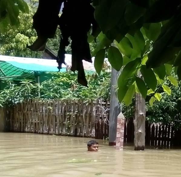
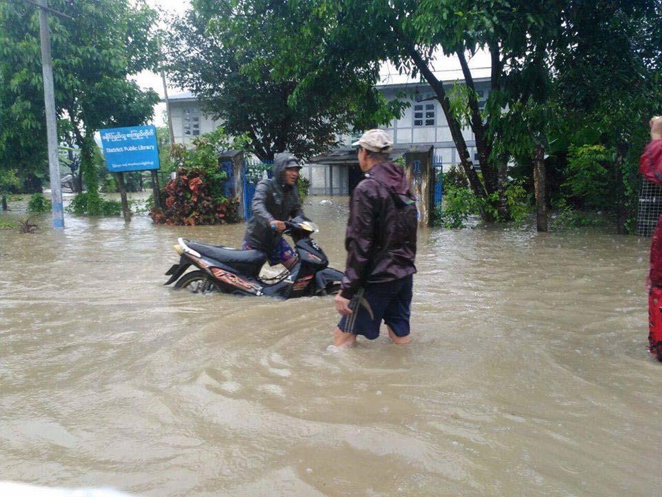

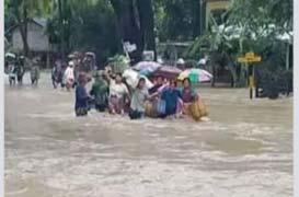
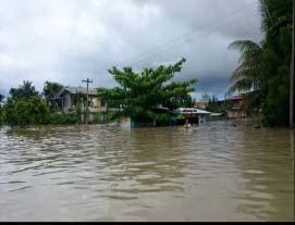
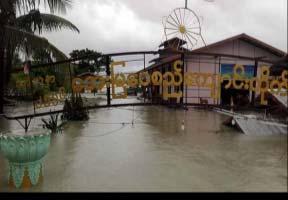
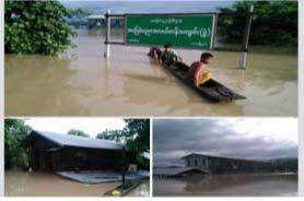
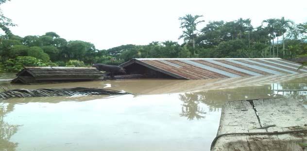
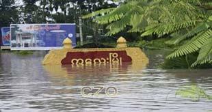
20 2016 Floods Photos
21 Issuing Flood Warnings and Bulletins during 2016 Rivers Types of News SWLB FW FB 1.Ayeyarwady Chindwin Sittoung 4.Shwegyin Bago 2-6.Thanlwin 2-7.Ngawun Dokehtawady Kalaten( start date ) Toe( start date ) Lay Myo( start date ) - - Total SWLB Significant Water Level Bulletin FW FB Flood Warning Flood Bulletin
 Flood Frequency Mkyina Bhamo Katha Mdly Sgaing Myinmu Pakokku N OO")


22 Review on the occurrences of floods in Flood Frequency Flood Frequency 2015(Monsson Season) Flood Frequency Mkyina Bhamo Katha Mdly Sgaing Myinmu Pakokku N OO Chauk Minbu Magway Aunglan Pyay Seiktha Hinthada Zalun Hkamti Homalin P Pyin Mawlaik Kalewa Mingin Monywa Hsipaw S S Yan Myinge Toungoo Madauk Shwekyin ZaungTu Bago Hpaan NTG Annual peak water levels at 8 major rivers on Myitkyina Bhamo Katha Mandalay Sagaing Myinmu Pakokku Nyaungoo Chauk Minbu Magway Aunglan Pyay Seiktha Hinthada Zalun Hkamti Homalin P Pyain Mawlaik Kalewa Mingin Monywa Hsipaw Ssyan Myitnge Toungoo Madauk Shwegyin Zaungtu Bago Hpaan NTG Water Levels(FT)
23 Review on the occurrences of floods in 2015 Rivers Types of News SWLB FW FB Ayeyarwady Chindwin Sittoung Shwegyin Bago Thanlwin Ngawun Dokehtawady Total SWLB Significant Water Level Bulletin FW FB Flood Warning Flood Bulletin
")
24 Comparison of One Week Observed Rainfall and July Normal Rainfall (Due to Cyclone Komen )
25 Disasters due to Cyclone Komen in Myanmar (2015)


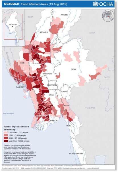

26 Flood affected areas and affected people(july, 2015)
27 2015 Severe flood in Myanmar Cause - severe flood and landslide by unusually heavy rainfall and also cyclone Komen Period - 20 July 2015 to August Affected areas - 12 States and Regions except from Kayah and Thanintharyi H.E President, in line with the section 11 of Natural Disaster Management Law, declared Chin State, Sagaing Region, Magway Region and Rakhine State as the worst disasteraffected areas on July 31.
28 NO States/ Regions Damages by flood (2015) Damaged houses Affected households Affected people Death toll 1 Sagaing Kachin Shan Mandalay Chin Mon Magway Yangon Rakhine Kayin Bago Ayeyarwaddy Thanintharyi Kayah Total 39, ,208 1,692,
29 Replanting in the Flooded Area (2015) No. Regions/ States Flooded Acre Affected Acre Damaged Acre Replanting Acre 1 Nay Pyi Taw Kachin Kayar Kayin Chin Sagaing Pago Magway Mandalay Mon Rakaing Yangon Shan Ayeyawaddy Total
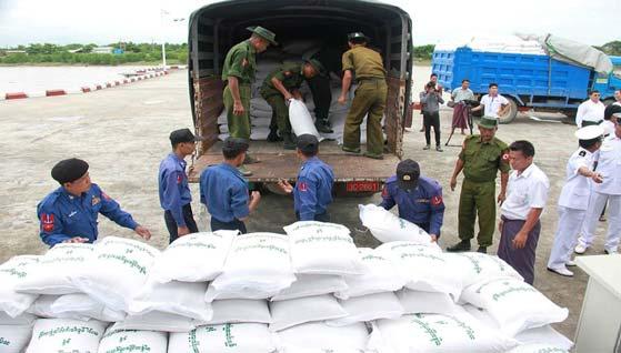
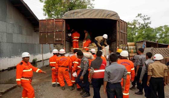

30 Contribution of humanitarian assistances(2015) Receiving Donation for flood (2015)

31 6 Flood frequency during 2013 monsoon season at 8 major rivers 5 4 Flood frequency Mkyina Bhamo Katha Mdly Sgaing Pakokku NU Chauk Minbu Magway Aunglan Pyay Seiktha Hintha Zalun Hkamti Homalin Mawlaik Kalewa Monywa Hsipaw Myinge Toungoo Madauk Shwe Zaung Bago Hpaan NTG 0 Flood Frequency MKN Bhamo Katha Mandalay Sagaing Pakokku Nyaung Oo Chauk Minbu Magway Aunglan Pyay Seiktha Hinthada Zalun Hkamti Homalin Mawlaik Kalewa Monywa Myitnge Toungoo Madauk Shwegyin Hpaan ZTU Bago NTG Flood Frequency during 2014 Monsoon Season Flood Frequency

 100 200 300")


 Relief camp - 72")

32 Flood Hydrograph at Toungoo of Sittoung River (2013) 0 Danger Level (600) cm 2 nd Highest Record ( ) Water Level (cm) 1-Jul-13 8-Jul Jul Jul Jul-13 5-Aug Aug Aug Aug-13 2-Sep-13 9-Sep Sep Sep Sep-13 7-Oct Oct Oct Oct-13 4-Nov-13 Rainfall (mm) Relief camp - 72 Affected Population Affected Paddy and Crop acres Damaged Paddy and Crop - > acres

 Flood")
33 Mkyina Bhamo Katha Mdly Sgaing Pakokku NU Chauk Minbu Magway Aunglan Pyay Seiktha Hinthada Zalun Hkamti Homalin Mawlaik Kalewa Monywa Hsipaw Myinge Toungoo Madauk Shwekyin ZaungTu Bago Hpaan NTG Flood Frequency in 2012(Monsoon Season) 系列 1 Mkyina Bhamo Katha Mdly Sgaing Pakokku NU Chauk Minbu Magway Aunglan Pyay Seiktha Hinthada Zalun Hkamti Homalin Mawlaik Kalewa Monywa Hsipaw Myinge Toungoo Madauk Shwekyin ZaungTu Bago Hpaan NTG Flood Frequency in 2011(Monsoon Season) Flood
 900")


 ft flood depth 20 wards were inundated Flood affected")
34 2012 Flood 3 rd Highest ( ) of Shwegyin of Shwegyin River Flood Hydrograph of Shwegyin of Shwegyin River (2012) water level (cm ) Danger Level (700) cm Jun 8-Jun 15-Jun 22-Jun 29-Jun 6-Jul 13-Jul 20-Jul 27-Jul 3-Aug 10-Aug 17-Aug 24-Aug 31-Aug 7-Sep 14-Sep 21-Sep 28-Sep 5-Oct 12-Oct 19-Oct 26-Oct 600 Flood duration is 10 days Inundated ¾ of the total area (3 to 4.5) ft flood depth 20 wards were inundated Flood affected population was about 11255

35 Comparison of 2010 and 2011 Water Levels of Toungoo of Sittoung River Danger Level 600 cm Pakokku Seiktha Zalun NTG Zaugtu Comparison of 2010 and 2011 Water Levels of Hpaan of Thanlwin River Danger Level 750 cm 1-May 15-May 29-May 12-Jun 26-Jun 10-Jul 24-Jul 7-Aug 21-Aug 4-Sep 18-Sep 2-Oct 16-Oct 30-Oct water level (cm) 1-May 15-May 29-May 12-Jun 26-Jun 10-Jul 24-Jul 7-Aug 21-Aug 4-Sep 18-Sep 2-Oct 16-Oct 30-Oct Date Comparison of 2010 and 2011 Water Levels of Madauk of Sittoung River Danger Level Date water level (cm) water level (cm) 1-May 15-May 29-May 12-Jun 26-Jun 10-Jul 24-Jul 7-Aug 21-Aug 4-Sep 18-Sep 2-Oct 16-Oct 30-Oct Date 2011 Annual Peak/ Lowest Water level 4 th Lowest (1967~2011) 1 st Lowest (1967~2011) 2 nd Lowest (1968~2011) 2 nd Lowest (1966~2011) 3 rd Lowest (1968~2011) 4 th Lowest (1968~2011) 1 st Highest ( ) 2 nd Highest ( ) Fig (9) Comparison of 2010 Water Level and 2011 Water Level during Monsoon Period at Shwegyin of Shwegyin River 800 Danger Level (700 cm) water level (cm) Water Level 2011 Water Level 1-Jun 8-Jun 15-Jun 22-Jun 29-Jun 6-Jul 13-Jul 20-Jul 27-Jul 3-Aug 10-Aug 17-Aug 24-Aug 31-Aug 7-Sep 14-Sep 21-Sep 28-Sep 5-Oct 12-Oct 19-Oct 26-Oct Floods in Fig (1) Comparison of 2010 Water Level and 2011 Water Level during Monsoon Period at Myitkyina of Ayeyarwady River Danger Level (1200 cm) Date water level (cm) Fig (4) Comparison of 2010 Water Level and 2011 Water Level during Monsoon Period at Hkamti of Chindwin River Danger Level (1360 cm) Water Level 2011 Water Level 1-Jun 8-Jun 15-Jun 22-Jun 29-Jun 6-Jul 13-Jul 20-Jul 27-Jul 3-Aug 10-Aug 17-Aug 24-Aug 31-Aug 7-Sep 14-Sep 21-Sep 28-Sep 5-Oct 12-Oct 19-Oct 26-Oct Date Water Level 2011 Water Level 0 1-Jun 8-Jun 15-Jun 22-Jun 29-Jun 6-Jul 13-Jul 20-Jul 27-Jul 3-Aug 10-Aug 17-Aug 24-Aug 31-Aug 7-Sep 14-Sep 21-Sep 28-Sep 5-Oct 12-Oct 19-Oct 26-Oct Date water level (cm)
36 Recorded Floods during 2011 to 2016 Year River Station/ Recorded Flood Levels Total Stations (above DL) 2011 Bago/Thanlwin Bago (1 st ), Paan(2 nd ) 13 stations 2012 Shwegyin Shwegyin (3 rd ) 9 stations 2013 Sittoung Toungoo (2 nd ) 14 stations 2014 Bago Bago (4 th ) 11 stations 2015 Chindwin/ Ayeyarwady/ Ngawun Monywa (1 st ), Kalewa(2 nd ),Seiktha (2 nd ), Zalun(2 nd ) Pakokku(3 rd ), Nyang Oo(3 rd ), Aunglan(3 rd ), Pyay(3 rd ), Hinthada(3 rd ), Ntg(4 th ) 23 stations 2016 Ayeyarwady/Ngawun Nyang Oo (1 st ), Zalun(1 st ), Pathein(1 st ) 29 stations

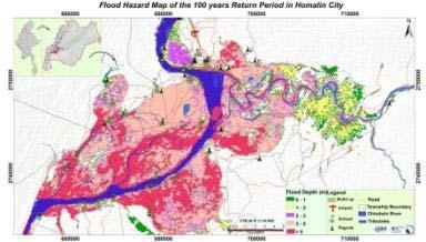
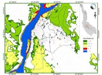
37 Flood hazard mapping


38 - Flood Mapping - Funding by ADB/ Technical Support by ICHARM & CTI, JAPAN
39 ONGOING ACTIVITIES The project for establishment of disastrous weather monitoring system (3 Radars and 30 AWOS) (JICA Funding) ( ) Development and Implementation of User-Relevant End-to-End Flood Forecast Generation for Myanmar( Technical support by RIMES and Indian Gov. Funding) (April 2014 March 2017)( Installation of 13 TWLMS and 2 AWOS and Flood forecast model development) AIRBM Project (Component 2: Hydro met Observation and Information System Modernization (WB Project) ( ) Developing a methodology for flood forecasting for a selected river basin in Myanmar (Hydrological Modelling System) ( ) (Technical support by NVE & ADPC and Norway Gov. Funding) (Hydrological modeling, Develop Flood Hazard Map, Drills and simulations for floods for pilot sites (Kale, Kalewa) To install 90 AWOS and 10 (TWLMS) by Gov. Budget ( Budget yr) Modernization of Forecasting and Warning System for Natural Disaster in Myanmar ( ) (Korea Gov. Funding, KMA and KMIPA) (AWS installation) To Develop Flood Early Warning for Thanlwin river basin (DMCD Project, Funding by MLIT, Japan (IDI, CTI, YEC )

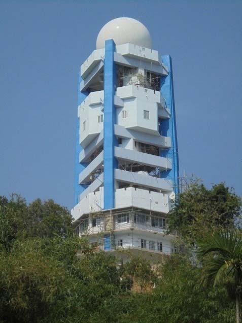
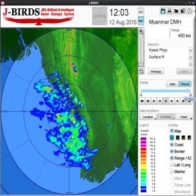

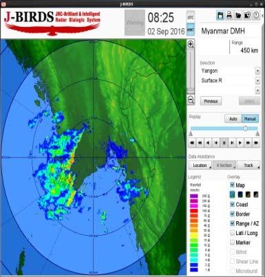
40 Project for establishment of disastrous weather monitoring system (3 Radars and 30 AWOS) Kyaukphyu Yangon

41 Development and Implementation of User-Relevant End-to-End Flood Forecast Generation for Myanmar Ayeyarwady, Chindwin & Sittaung Basins Installation of 13 TWLMS and 2 AWOS Flood Forecast Model Development
42 Future Plans / Requirements to improve existing flood forecasting system To upgrade the observation system (instruments and network) To upgrade the Data management system To upgrade the Early Warning Dissemination System To upgrade the discharge/sediment measurement instruments and also discharge/sediment observations To develop the advance and effective flood forecasting techniques Capacity Building (Education, Training) To establish the flood detection system (such as CCTV monitoring system) To establish the flash flood guidance system To upgrade the RS and GIS section especially for Flood Hazard Mapping (software, high resolution DEM and satellite images, techniques, CB) To improve the Flood Hazard mapping To upgrade the long range flood forecast techniques (seasonal and monthly) To develop the studying and analysis of climate change impact on floods
43 CONCLUSION DMH will cooperate and collaborate with the local and international organizations to upgrade the Flood Forecasting System to reduce the flood risks in Myanmar.
Applications of Space Technology and GIS for Disaster Risk Reduction and Sustainable Development in Myanmar
 Applications of Space Technology and GIS for Disaster Risk Reduction and Sustainable Development in Myanmar Ms. Tin Yi Deputy Director Department of Meteorology and Hydrology MYANMAR Natural hazards Meteorological
Regional Seminar on Aviation Meteorology Service in Asia Beijing, China (11-15 April 2011)
") Regional Seminar on Aviation Meteorology Service in Asia Beijing, China (11-15 April 2011) Aviation Meteorology Service in Myanmar Mr.Hla Shwe Staff Officer Department of Meteorology and Hydrology Myanmar
Regional Seminar on Aviation Meteorology Service in Asia Beijing, China (11-15 April 2011) Aviation Meteorology Service in Myanmar Mr.Hla Shwe Staff Officer Department of Meteorology and Hydrology Myanmar
Overview of existing Weather Forecasting and Warning infrastructures in Myanmar
 Overview of existing Weather Forecasting and Warning infrastructures in Myanmar by Dr. Zin Mie Mie Sein Officer (DMH) 26. February. 2018 Nay Pyi Taw Outline Introduction Myanmar & its disasters Meteorological
Flood Inundation Analysis by Using RRI Model For Chindwin River Basin, Myanmar
 Flood Inundation Analysis by Using RRI Model For Chindwin River Basin, Myanmar Aye Aye Naing Supervisor : Dr. Miho Ohara MEE14625 Dr. Duminda Perera Dr. Yoshihiro Shibuo ABSTRACT Floods occur during the
CHAPTER-HI RAINFALL VARIABILITY IN MYANMAR
 CHAPTER-HI RAINFALL VARIABILITY IN MYANMAR 3.1 Introduction Rainfall variability is of great practical significance in water resource analysis. It explains the availability of water at a particular time
Flash Flood in Myanmar
 Flash Flood in Myanmar Presented by : Su Nandar Myint (Ms.) Staff Officer Emergency Operation Center Department of Disaster Management 26 th February 2018 Multi Hazard Early Warning Center, DMH Contents
Tokyo, Japan March Discussed By: May Khin Chaw, Kyaw Lwin Oo. Department of Meteorology and Hydrology
 Tokyo, Japan 11-14 March 2014 Discussed By: May Khin Chaw, Kyaw Lwin Oo Department of Meteorology and Hydrology Manpower: Out of DMH s total (1425), we are Working with (780) Staffs. 55% (37) stations
COUNTRY PRESENTATION ON MR JAYNAL ABEDIN JOINT SECRETARY ( WORKS & DEVELOPMENT ) MINISTRY OF DEFENCE
 MINISTRY OF DEFENCE") COUNTRY PRESENTATION ON By MR JAYNAL ABEDIN JOINT SECRETARY ( WORKS & DEVELOPMENT ) MINISTRY OF DEFENCE Bangladesh Geographical Location of Bangladesh Bangladesh Country at a Glance Physical Features 1,230
COUNTRY PRESENTATION ON By MR JAYNAL ABEDIN JOINT SECRETARY ( WORKS & DEVELOPMENT ) MINISTRY OF DEFENCE Bangladesh Geographical Location of Bangladesh Bangladesh Country at a Glance Physical Features 1,230
Joint Meeting of RA II WIGOS Project and RA V TT-SU on 11 October 2018 BMKG Headquarter Jakarta, Indonesia. Mrs. Sinthaly CHANTHANA
 Joint Meeting of RA II WIGOS Project and RA V TT-SU on 11 October 2018 BMKG Headquarter Jakarta, Indonesia Mrs. Sinthaly CHANTHANA Lao PDR Background Department of Meteorology and Hydrology ( DMH ) in
Recent development of the National Hydro-Meteorological Service (NHMS) of Viet Nam for disaster risk reduction
 of Viet Nam for disaster risk reduction") Ministry of Natural Resources and Environment National Hydro-Meteorological Service Recent development of the National Hydro-Meteorological Service (NHMS) of Viet Nam for disaster risk reduction Tran Van
Ministry of Natural Resources and Environment National Hydro-Meteorological Service Recent development of the National Hydro-Meteorological Service (NHMS) of Viet Nam for disaster risk reduction Tran Van
Climate Variabilities, Extremes and Trends in Central Dry, Coastal and Hilly Zones
 CLIMATE PROFILE Climate Variabilities, Extremes and Trends in Central Dry, Coastal and Hilly Zones MYANMAR This has been prepared by the Regional Integrated Multi-Hazard Early Warning System (RIMES), as
ANALYSIS OF FLOODS AND DROUGHTS IN THE BAGO RIVER BASIN, MYANMAR, UNDER CLIMATE CHANGE
 ANALYSIS OF FLOODS AND DROUGHTS IN THE BAGO RIVER BASIN, MYANMAR, UNDER CLIMATE CHANGE Myo Myat Thu* MEE15631 ABSTRACT 1 Supervisor: Dr. Maskym Gusyev** Dr. Akira Hasegawa** This study investigates floods
JCOMM-CHy Coastal Inundation Forecasting Demonstration Project (CIFDP)
") WMO World Meteorological Organization Working together in weather, climate and water JCOMM-CHy Coastal Inundation Forecasting Demonstration Project (CIFDP) Coastal Flooding & Vulnerable Populations Coastal
WMO World Meteorological Organization Working together in weather, climate and water JCOMM-CHy Coastal Inundation Forecasting Demonstration Project (CIFDP) Coastal Flooding & Vulnerable Populations Coastal
Country Presentation-Nepal
 Country Presentation-Nepal Mt.Everest, Shiva Pd. Nepal, DHM South Asia Drought Monitor Workshop Dhaka Bangladesh 2 th April 215 Overview Brief Climatology Climate activities- DHM PPCR (Pilot Program for
COUNTRY REPORT. Jakarta. July, th National Directorate of Meteorology and Geophysics of Timor-Leste (DNMG)
") The Southeastern Asia-Oceania Flash Flood COUNTRY REPORT Jakarta. July, 10-12 th 2017 National Directorate of Meteorology and Geophysics of Timor-Leste (DNMG) Carla Feritas and Crisostimo Lobato Democratic
The Southeastern Asia-Oceania Flash Flood COUNTRY REPORT Jakarta. July, 10-12 th 2017 National Directorate of Meteorology and Geophysics of Timor-Leste (DNMG) Carla Feritas and Crisostimo Lobato Democratic
National Report on Weather Forecasting Service
 MINISTRY OF WATER RESOURCES AND METEOROLOGY DEPARTMENT OF METEOROLOGY, CAMBODIA National Report on Weather Forecasting Service Tokyo, 11-15 March 2014 Department of Meteorology, Cambodia Presentation Outline
Bistandsprosjekter i Sørøst-Asia
 Bistandsprosjekter i Sørøst-Asia -Sikre liv og verdier Lars R. Hole, Hanneke Luijting, Tor Ivar Mathisen og Kristine Gjesdal September 2017 Norwegian Meteorological Institute Background Ministry of Foreign
Saiful Islam Anisul Haque
 Workshop on Disaster Prevention/Mitigation Measures against Floods and Storm Surges in Bangladesh on 17-21 November, 2012, in Kyoto University, Japan Component 2: Flood disaster risk assessment and mitigation
Role of Hydro-Met Services in Disaster Risk Management
 Role of Hydro-Met Services in Disaster Risk Management Tshewang Rigzin (Mr) National Centre for Hydrology and Meteorology, Bhutan 30 th November 2017 Outline Vision and Mission Functions related to Disaster
JMA/WMO WORKSHOP ON EFFECTIVE TROPICAL CYCLONE WARNING IN SOUTHEAST ASIA
 JMA/WMO WORKSHOP ON EFFECTIVE TROPICAL CYCLONE WARNING IN SOUTHEAST ASIA TROPICAL CYCLONE MONITORING IN LAO PDR TOKYO, JAPAN 11 14 March 2014 Ministry of Natural Resource and Environment (MONRE) Department
Proposal Report On Flood Hazards Mapping Project In Xebangfai River
 Proposal Report On Flood Hazards Mapping Project In Xebangfai River Prepared By Mr. Boualaythong KOUMPHONH Climate Division Department of Meteorology and Hydrology Water Resources and Environment Administration
Application of Satellite Data for Flood Forecasting and Early Warning in the Mekong River Basin in South-east Asia
 MEKONG RIVER COMMISSION Vientiane, Lao PDR Application of Satellite Data for Flood Forecasting and Early Warning in the Mekong River Basin in South-east Asia 4 th World Water Forum March 2006 Mexico City,
Climatological onset dates of summer monsoon over Myanmar
 INTERNATIONAL JOURNAL OF CLIMATOLOGY Int. J. Climatol. 31: 382 393 (11) Published online 1 February in Wiley Online Library (wileyonlinelibrary.com) DOI:.2/joc.76 Climatological onset dates of summer monsoon
Use of Climate information in Disaster Risk Management in Zimbabwe
 Use of Climate information in Disaster Risk Management in Zimbabwe WMO Regional Technical Meeting & User/CONOPS Workshop, 28 th October 2015 Lameck Betera Department of Civil Protection Institutional Arrangements
Flash flood forecasting and warning infrastructures of National Meteorology and Hydrological Services of Cambodia
 Development and Implementation of the South East Asia Flash Flood Guidance System (SEAFFGS) Ha Noi, Viet Nam, 20-23 November 2017 Flash flood forecasting and warning infrastructures of National Meteorology
EFFECTIVE TROPICAL CYCLONE WARNING IN BANGLADESH
 Country Report of Bangladesh On EFFECTIVE TROPICAL CYCLONE WARNING IN BANGLADESH Presented At JMA/WMO WORKSHOP ON EFFECTIVE TROPICAL CYCLONE WARNING IN SOUTHEAST ASIA Tokyo, Japan,11-14 March 2014 By Sayeed
Flood Inundation Mapping under different climate change scenarios in the upper Indus River Basin, Pakistan
 Flood Inundation Mapping under different climate change scenarios in the upper Indus River Basin, Pakistan Sohaib Baig (doctoral student) 16 November 2017 Disaster Prevention Research Institute 1 Kyoto
Chiang Rai Province CC Threat overview AAS1109 Mekong ARCC
 Chiang Rai Province CC Threat overview AAS1109 Mekong ARCC This threat overview relies on projections of future climate change in the Mekong Basin for the period 2045-2069 compared to a baseline of 1980-2005.
South Asia Flash Flood Guidance System Operational Workshop (Step-4)
") South Asia Flash Flood Guidance System Operational Workshop (Step-4) (5 th to 7 th June 2018) Operational Flash Flood Forecasting and Early Warnings Capabilities in Bhutan (Sonam Tashi) Weather Forecaster
South Asia Flash Flood Guidance System Operational Workshop (Step-4) (5 th to 7 th June 2018) Operational Flash Flood Forecasting and Early Warnings Capabilities in Bhutan (Sonam Tashi) Weather Forecaster
CLIMATE CHANGE ADAPTATION BY MEANS OF PUBLIC PRIVATE PARTNERSHIP TO ESTABLISH EARLY WARNING SYSTEM
 CLIMATE CHANGE ADAPTATION BY MEANS OF PUBLIC PRIVATE PARTNERSHIP TO ESTABLISH EARLY WARNING SYSTEM By: Dr Mamadou Lamine BAH, National Director Direction Nationale de la Meteorologie (DNM), Guinea President,
Progress Report. Flood Hazard Mapping in Thailand
 Progress Report Flood Hazard Mapping in Thailand Prepared By: Mr. PAITOON NAKTAE Chief of Safety Standard sub-beuro Disaster Prevention beuro Department of Disaster Prevention and Mitigation THAILAND E-mail:
FFGS Advances. Initial planning meeting, Nay Pyi Taw, Myanmar February, Eylon Shamir, Ph.D,
 FFGS Advances Initial planning meeting, Nay Pyi Taw, Myanmar 26-28 February, 2018 Eylon Shamir, Ph.D, EShamir@hrcwater.org Hydrologic Research Center San Diego, California FFG System Enhancements The following
Steering Committee on Global Flash Flood Guidance 29 November 2016, Inter-Continental Hotel, Phnom Penh. Cambodia National Weather Services
 Steering Committee on Global Flash Flood Guidance 29 November 2016, Inter-Continental Hotel, Phnom Penh Cambodia National Weather Services Activities and Responsibilities of Research and Flood Forecasting
Government of Sultanate of Oman Public Authority of Civil Aviation Directorate General of Meteorology. National Report To
 Government of Sultanate of Oman Public Authority of Civil Aviation Directorate General of Meteorology National Report To Panel on Tropical Cyclones in the Bay of Bengal And Arabian Sea 43rd Session, India
Regional Flash Flood Guidance and Early Warning System
 WMO Training for Trainers Workshop on Integrated approach to flash flood and flood risk management 24-28 October 2010 Kathmandu, Nepal Regional Flash Flood Guidance and Early Warning System Dr. W. E. Grabs
Thai Meteorological Department, Ministry of Digital Economy and Society
 Thai Meteorological Department, Ministry of Digital Economy and Society Three-month Climate Outlook For November 2017 January 2018 Issued on 31 October 2017 -----------------------------------------------------------------------------------------------------------------------------
OVERVIEW OF IMPROVED USE OF RS INDICATORS AT INAM. Domingos Mosquito Patricio
 OVERVIEW OF IMPROVED USE OF RS INDICATORS AT INAM Domingos Mosquito Patricio domingos.mosquito@gmail.com Introduction to Mozambique /INAM Introduction to AGRICAB/SPIRITS Objectives Material & Methods Results
Procurement Plan National Community Driven Development Project Department of Rural Development
 Public Disclosure Authorized I. General Procurement Plan National Community Driven Project Department of Rural Public Disclosure Authorized Public Disclosure Authorized Public Disclosure Authorized 1.
Analysis of Historical Pattern of Rainfall in the Western Region of Bangladesh
 24 25 April 214, Asian University for Women, Bangladesh Analysis of Historical Pattern of Rainfall in the Western Region of Bangladesh Md. Tanvir Alam 1*, Tanni Sarker 2 1,2 Department of Civil Engineering,
International Flood Network - IFNet
 International Flood Network - IFNet - Akira Sasaki Deputy Director General IFNet Secretariat Today s s Contents 1. IFNet (International Flood Network) 2. GFAS (Global Flood Alert System) Increasing Flood
Mekong River Commission
 U Mekong River Commission Regional Flood Management and Mitigation Centre Weekly Flood Situation Report for the Mekong River Basin Prepared on: 7//, covering the week from the th August to the th August
UPDATE OF REGIONAL WEATHER AND SMOKE HAZE (December 2017)
") UPDATE OF REGIONAL WEATHER AND SMOKE HAZE (December 2017) 1. Review of Regional Weather Conditions for November 2017 1.1 In November 2017, Southeast Asia experienced inter-monsoon conditions in the first
UPDATE OF REGIONAL WEATHER AND SMOKE HAZE (December 2017) 1. Review of Regional Weather Conditions for November 2017 1.1 In November 2017, Southeast Asia experienced inter-monsoon conditions in the first
Japanese Programs on Space and Water Applications
 Japanese Programs on Space and Water Applications Tamotsu IGARASHI Remote Sensing Technology Center of Japan June 2006 COPUOS 2006 Vienna International Centre Water-related hazards/disasters may occur
HISTORY OF HEAVY RAINFALL DISASTER INFORMATION IN JAPAN
 transmission, for a state-of-the-art review. In addition, issues expected to arise in the future are discussed. HISTORY OF HEAVY RAINFALL DISASTER INFORMATION IN JAPAN Progress of Rainfall Observation
HEAVY RAIN OVER MID-CENTRAL REGION OF VIETNAM
 HEAVY RAIN OVER MID-CENTRAL REGION OF VIETNAM ----------------------------------------------------------------------- S.Eng. Dang Thi Mai; Dr. Nguyen Thi Tan Thanh National Hydro Meteorological Service
Technical Assistance Consultant s Report
 Technical Assistance Consultant s Report Project Number: 46496-001 December 2016 Republic of the Union of Myanmar: Transformation of Urban Management - Flood Management Component (Financed by the Japanese
Three main areas of work:
 Task 2: Climate Information 1 Task 2: Climate Information Three main areas of work: Collect historical and projected weather and climate data Conduct storm surge and wave modeling, sea-level rise (SLR)
Mekong River Commission
 U Mekong River Commission Regional Flood Management and Mitigation Centre Weekly Flood Situation Report for the Mekong River Basin th Prepared on: Monday, /9, covering the week from P P August to 31 st
Mekong River Commission
 U Mekong River Commission Regional Flood Management and Mitigation Centre Weekly Flood Situation Report for the Mekong River Basin Prepared on: //9, covering the week from 19 to October 9 Weather Patterns,
Project Name: Implementation of Drought Early-Warning System over IRAN (DESIR)
") Project Name: Implementation of Drought Early-Warning System over IRAN (DESIR) IRIMO's Committee of GFCS, National Climate Center, Mashad November 2013 1 Contents Summary 3 List of abbreviations 5 Introduction
Project Name: Implementation of Drought Early-Warning System over IRAN (DESIR) IRIMO's Committee of GFCS, National Climate Center, Mashad November 2013 1 Contents Summary 3 List of abbreviations 5 Introduction
10 emergency observation requests were successfully processed during the period
 ISRO s Inputs for the Sentinel Asia DPN and JPT meeting being held during 13-16, 16, November 2012 November 2012 Sentinel Asia Activity Spectrum - A dedicated Sentinel Asia server established at NRSC,
Republic of Mozambique
 Republic of Mozambique Second Expert's Symposium on Multi-Hazard Early Warning Systems with focus on the Role of National Meteorological and Hydrological Services 5-7 May 2009, Toulouse France 1. Background
The Global Flood Awareness System
 The Global Flood Awareness System David Muraro, Gabriele Mantovani and Florian Pappenberger www.globalfloods.eu 1 Forecasting chain using Ensemble Numerical Weather Predictions Flash Floods / Riverine
Theme 4. Disaster Mitigation and Risk Management
 Theme 4 Disaster Mitigation and Risk Management World Flood Map in 2002 Released by WMO as of August 29 Over 17 million were affected (in more than 80 countries) 3,000 were killed Total damage of over
Study of Hydrometeorology in a Hard Rock Terrain, Kadirischist Belt Area, Anantapur District, Andhra Pradesh
 Open Journal of Geology, 2012, 2, 294-300 http://dx.doi.org/10.4236/ojg.2012.24028 Published Online October 2012 (http://www.scirp.org/journal/ojg) Study of Hydrometeorology in a Hard Rock Terrain, Kadirischist
MEMBER REPORT. ESCAP/WMO Typhoon Committee 8 th Integrated Workshop/2 nd TRCG Forum (CAMBODIA)
") MEMBER REPORT ESCAP/WMO Typhoon Committee 8 th Integrated Workshop/2 nd TRCG Forum (CAMBODIA) Macao, China 2-6 December 2013 CONTENTS I. Overview of tropical cyclones which have affected/impacted Member
MEMBER REPORT ESCAP/WMO Typhoon Committee 8 th Integrated Workshop/2 nd TRCG Forum (CAMBODIA) Macao, China 2-6 December 2013 CONTENTS I. Overview of tropical cyclones which have affected/impacted Member
Mekong River Commission
 Mekong River Commission Regional Flood Management and Mitigation Centre Weekly Flood Situation Report for the Mekong River Basin Prepared on: Monday, /9, covering the week from 13 rd July to th July 9
1. Introduction. 2. Verification of the 2010 forecasts. Research Brief 2011/ February 2011
 Research Brief 2011/01 Verification of Forecasts of Tropical Cyclone Activity over the Western North Pacific and Number of Tropical Cyclones Making Landfall in South China and the Korea and Japan region
EARLY WARNING IN SOUTHERN AFRICA:
 EARLY WARNING IN SOUTHERN AFRICA: Enhancing the Meteorological Early Warning System Eugene Poolman South African Weather Service OUTLINE OF PRESENTATION Impact of Climate Change Meteorological Early Warning
Mekong River Commission
 Mekong River Commission Regional Flood Management and Mitigation Centre Weekly Flood Situation Report for the Mekong River Basin Prepared on: 5//9, covering the week from the th of September to the 5 th
CURRENT METHODS AND PRODUCTS OF SEASONAL PREDICTION IN KENYA
 CURRENT METHODS AND PRODUCTS OF SEASONAL PREDICTION IN KENYA BY Mr. PETER G. AMBENJE Deputy Director Kenya Meteorological Department Box 3259-1 NAIROBI OUTLINE Introduction Brief Geography of Kenya Brief
Overview and purposes of the meeting
 Overview and purposes of the meeting 1 Flash Floods vs. River Floods Riverine Flooding: is caused by heavy rainfall (and/or snow melt) over long periods e.g., days, leading to rising water levels and flooding
Mekong River Commission Regional Flood Management and Mitigation Centre
 U U Mekong River Commission Regional Flood Management and Mitigation Centre Weekly Flood Situation Report for the Mekong River Basin Prepared on: //9, covering the week from the nd October to the 19 th
NW Pacific and Japan Landfalling Typhoons in 2000
 NW Pacific and Japan Landfalling Typhoons in 2000 Pre-Season Forecast Issued 26th May, 2000 Produced under contract for TSUNAMI in collaboration with the UK Met. Office by Drs Paul Rockett, Mark Saunders
Community-Based Flood Early Warning System (CBFEWS)
") Community-Based Flood Early Warning System (CBFEWS) Prepared by: Eng r. Hilario G. Esperanza Eng r.. Socrates F. Paat,, Jr. Flood Forecasting Branch PAGASA Weather Bureau Department of Science and Technology
Community-Based Flood Early Warning System (CBFEWS) Prepared by: Eng r. Hilario G. Esperanza Eng r.. Socrates F. Paat,, Jr. Flood Forecasting Branch PAGASA Weather Bureau Department of Science and Technology
JICA s Cooperation for NMHSs. Taisuke Watanabe Japan International Cooperation Agency
 JICA s Cooperation for NMHSs Taisuke Watanabe 28 Oct, 2014 JICA s Assistant Approach for Hydrological and Meteorological Services Assistance for improvement of Hydrological and Meteorological Services
Use of Geospatial data for disaster managements
 Use of Geospatial data for disaster managements Source: http://alertsystemsgroup.com Instructor : Professor Dr. Yuji Murayama Teaching Assistant : Manjula Ranagalage What is GIS? A powerful set of tools
Using Reanalysis SST Data for Establishing Extreme Drought and Rainfall Predicting Schemes in the Southern Central Vietnam
 Using Reanalysis SST Data for Establishing Extreme Drought and Rainfall Predicting Schemes in the Southern Central Vietnam Dr. Nguyen Duc Hau 1, Dr. Nguyen Thi Minh Phuong 2 National Center For Hydrometeorological
SAWIDRA Southern Africa
 SAWIDRA Southern Africa Presenter: Thembani Moitlhobogi Assistant Database and IT Expert SADC Climate Services Centre 13 th EUMETSAT Forum in Africa 24-28 September 2018, Abidjan, Cote d Ivoire Context
ROLE OF INDIA METEOROLOGICAL DEPARTMENT IN MANAGEMENT OF METEOROLOGICAL HAZARDS IN INDIA M MOHAPATRA
 ROLE OF INDIA METEOROLOGICAL DEPARTMENT IN MANAGEMENT OF METEOROLOGICAL HAZARDS IN INDIA M MOHAPATRA INDIA METEOROLOGICAL DEPARTMENT NEW DELHI-110003 mohapatraimd@gmail.com Introduction Presentation layout
PAGASA s Expectations of New-generation Satellites for Hazard Monitoring
 Country Report Philippines PAGASA s Expectations of New-generation Satellites for Hazard Monitoring VICENTE P. PALCON, JR. (Assistant Weather Services Chief) Weather Division- PAGASA DOST Email: vppalconjr@pagasa.dost.gov.ph
Global Flood Alert System based on satellite derived rainfall data -Targeting the era of Global Precipitation Measurement (GPM)-
-") Global Flood Alert System based on satellite derived rainfall data -Targeting the era of Global Precipitation Measurement (GPM)- Riko Oki, Misako Kachi (JAXA/EORC) Kazuhiko Fukami (PWRI) and Kazuo Umeda
Global Flood Alert System based on satellite derived rainfall data -Targeting the era of Global Precipitation Measurement (GPM)- Riko Oki, Misako Kachi (JAXA/EORC) Kazuhiko Fukami (PWRI) and Kazuo Umeda
Available online Journal of Scientific and Engineering Research, 2018, 5(3): Research Article
: Research Article") Available online www.jsaer.com, 2018, 5(3):166-180 Research Article ISSN: 2394-2630 CODEN(USA): JSERBR Impact of Climate Variability on Human Health- A Case Study at Kanchanpur Union, Basail, Tangail District,
Available online www.jsaer.com, 2018, 5(3):166-180 Research Article ISSN: 2394-2630 CODEN(USA): JSERBR Impact of Climate Variability on Human Health- A Case Study at Kanchanpur Union, Basail, Tangail District,
Landslide monitoring system in Iceland. Harpa Grímsdóttir Jón Kristinn Helgason NVE, Oslo, October
 Landslide monitoring system in Iceland Harpa Grímsdóttir Jón Kristinn Helgason NVE, Oslo, October 26 2016 History Avalanches and landslides have caused extensive damages and loss of human lives in Iceland
MekongRiver Commission
 U MekongRiver Commission Regional Flood Management and Mitigation Centre Weekly Flood Situation Report for the MekongRiver Basin Prepared at: //, covering the week from the 9 th July to the th August Weather
Utilization of satellite precipitation data for flood management
 Utilization of satellite precipitation data for flood management Tetsuya IKEDA Infrastructure Development Institute (IDI) Japan Typhoon Committee Integrated Workshop November 7, 2011 Nha Trang, Vietnam,
Hazard monitoring by using new generation satellite data: Pakistan Metrological Department s perspective
 Hazard monitoring by using new generation satellite data: Pakistan Metrological Department s perspective Ms. Humeira Hafeez Pakistan Meteorological Department Top Three Hazards Monsoon Activity Tropical
South Asian Climate Outlook Forum (SASCOF-6)
") Sixth Session of South Asian Climate Outlook Forum (SASCOF-6) Dhaka, Bangladesh, 19-22 April 2015 Consensus Statement Summary Below normal rainfall is most likely during the 2015 southwest monsoon season
Sixth Session of South Asian Climate Outlook Forum (SASCOF-6) Dhaka, Bangladesh, 19-22 April 2015 Consensus Statement Summary Below normal rainfall is most likely during the 2015 southwest monsoon season
Early Flood Warning System in Pakistan
 Early Flood Warning System in Pakistan By Muhammad Tahir Anwar Director General M/o National Food Security and Research Government of Pakistan Asian Water Cycle Forum 2016 March 1-2, 2016 Tokyo, Japan
High Resolution (20-km Mesh) Global Climate Model and Projected Hydro- Meteorological Extremes in the Future. Akio Kitoh
 Global Climate Model and Projected Hydro- Meteorological Extremes in the Future. Akio Kitoh") 2011.6.29, U-02, IUGG, Melbourne High Resolution (20-km Mesh) Global Climate Model and Projected Hydro- Meteorological Extremes in the Future Akio Kitoh Climate Research Department Meteorological Research
2011.6.29, U-02, IUGG, Melbourne High Resolution (20-km Mesh) Global Climate Model and Projected Hydro- Meteorological Extremes in the Future Akio Kitoh Climate Research Department Meteorological Research
9. Case study on disaster events using radar data
 9. Case study on disaster events using radar data 9 February 2018 Masahito ISHIHARA Former Meteorologist/Researcher of Japan Meteorological Agency Former Professor of Kyoto University 9. Case study on
Mekong River Commission
 U P August UPU U August P August P and P Mekong River Commission Regional Flood Management and Mitigation Centre Weekly Flood Situation Report for the Mekong River Basin th th Prepared on: Monday, /9,
FLOOD HAZARD AND RISK ASSESSMENT IN MID- EASTERN PART OF DHAKA, BANGLADESH
 FLOOD HAZARD AND RISK ASSESSMENT IN MID- EASTERN PART OF DHAKA, BANGLADESH Muhammad MASOOD MEE07180 Supervisor: Prof. Kuniyoshi TAKEUCHI ABSTRACT An inundation simulation has been done for the mid-eastern
Improving global coastal inundation forecasting WMO Panel, UR2014, London, 2 July 2014
 Improving global coastal inundation forecasting WMO Panel, UR2014, London, 2 July 2014 Cyclone Sidr, November 2007 Hurricane Katrina, 2005 Prof. Kevin Horsburgh Head of marine physics, UK National Oceanography
ANNOUNCEMENT WMO/ESCAP PANEL ON TROPICAL CYCLONES THIRTY-EIGHTH SESSION NEW DELHI, INDIA
 WMO IMD ESCAP ANNOUNCEMENT THIRTY-EIGHTH SESSION NEW DELHI, INDIA (21-25 February 2011) HISTORICAL BACKGROUND The tropical cyclones are particularly severe in the north Indian Ocean region. The northern
Seasonal Climate Outlook for South Asia (June to September) Issued in May 2014
 Issued in May 2014") Ministry of Earth Sciences Earth System Science Organization India Meteorological Department WMO Regional Climate Centre (Demonstration Phase) Pune, India Seasonal Climate Outlook for South Asia (June
Ministry of Earth Sciences Earth System Science Organization India Meteorological Department WMO Regional Climate Centre (Demonstration Phase) Pune, India Seasonal Climate Outlook for South Asia (June
National Public Weather and Warning Services in the Swaziland Meteorological Service Dennis S.Mkhonta /
 National Public Weather and Warning Services in the Swaziland Meteorological Service Dennis S.Mkhonta dennis.mkhonta@gmail.com / dennis@swazimet.gov.sz Introduction Swaziland s geographical position exposes
Overview of Early Warning Systems and the role of National Meteorological and Hydrological Services
 Overview of Early Warning Systems and the role of National Meteorological and Hydrological Services South Africa Second Experts Symposium on Multi-Hazard Early Warning Systems With focus on the Role of
ISSN Vol.03,Issue.10 May-2014, Pages:
 www.semargroup.org, www.ijsetr.com ISSN 2319-8885 Vol.03,Issue.10 May-2014, Pages:2187-2191 YIN YIN HTWE 1, AYE AYE THANT 2 1 Dept of Civil Engineering, Mandalay Technological University, Mandalay, Myanmar,
THE UNITED REPUBLIC OF TANZANIA MINISTRY OF WORKS, TRANSPORT AND COMMUNICATION TANZANIA METEOROLOGICAL AGENCY
 THE UNITED REPUBLIC OF TANZANIA MINISTRY OF WORKS, TRANSPORT AND COMMUNICATION TANZANIA METEOROLOGICAL AGENCY CLIMATE OUTLOOK FOR TANZANIA MARCH MAY, 2018 MASIKA RAINFALL SEASON Highlights for March May,
Mekong River Commission
 U U Mekong River Commission Regional Flood Management and Mitigation Centre Weekly Flood Situation Report for the Mekong River Basin Prepared on: 1/9/, covering the week from the th to the 1 th September
Departures AYEYARWADY CHINDWIN MyaNMar
 departures AYEYARWADY CHINDWIN Myanmar 2018-2019 2018 5 Days/ 4 Nights 4 Days / 3 Nights 3 Days / 2 Nights 16 Aug 2018 Golden Land Voyage - - 18 Aug 2018 30 Aug 2018 Golden Land Voyage - 2 Sept 2018 1
A Report on a Statistical Model to Forecast Seasonal Inflows to Cowichan Lake
 A Report on a Statistical Model to Forecast Seasonal Inflows to Cowichan Lake Prepared by: Allan Chapman, MSc, PGeo Hydrologist, Chapman Geoscience Ltd., and Former Head, BC River Forecast Centre Victoria
MEMBER REPORT CAMBODIA. Forty-fifth Session of the ESCAP/WMO Typhoon Committee Hongkong, China 29 January-1 February 2013
 MEMBER REPORT CAMBODIA Forty-fifth Session of the ESCAP/WMO Typhoon Committee Hongkong, China 29 January-1 February 2013 CONTENTS I. Overview of tropical cyclone which have affected /impacted Kingdom of
WMO Statement on the State of the Global Climate Preliminary conclusions for 2018 and WMO Greenhouse Bulletin
 WMO Statement on the State of the Global Climate Preliminary conclusions for 2018 and WMO Greenhouse Bulletin Dr Elena Manaenkova Deputy Secretary General World Meteorological Organisation Statement on
Flash Flood Guidance System On-going Enhancements
 Flash Flood Guidance System On-going Enhancements Hydrologic Research Center, USA Technical Developer SAOFFG Steering Committee Meeting 1 10-12 July 2017 Jakarta, INDONESIA Theresa M. Modrick Hansen, PhD
An Application of Hydrometeorological Information
 An Application of Hydrometeorological Information Weather-proof Café: Hydro-meteorological information in managing weather risks 17 19 November 2012 National Taiwan University, Chinese Taipei Nikos Viktor
Verification of the Seasonal Forecast for the 2005/06 Winter
 Verification of the Seasonal Forecast for the 2005/06 Winter Shingo Yamada Tokyo Climate Center Japan Meteorological Agency 2006/11/02 7 th Joint Meeting on EAWM Contents 1. Verification of the Seasonal
The Huong River the nature, climate, hydro-meteorological issues and the AWCI demonstration project
 The Huong River the nature, climate, hydro-meteorological issues and the AWCI demonstration project 7th GEOSS AP Symposium, the AWCI parallel session May 27, 214, Tokyo National Centre for Hydro-Meteorological
Ⅴ.. Global Flood Alert System
 Ⅴ.. Global Flood Alert System 1. Project Concept - An attempt to make the best use of Satellite Rainfall in FEW - Support for existing FEW activities where necessary 2. Collaboration between: i) Space