Remote Sensing and Wildfires
|
|
|
- Clarissa Townsend
- 5 years ago
- Views:
Transcription
1 Workshop, San Diego, 5-7 August 2013 Measuring, Quantifying, and Reporting Drought Impacts Remote Sensing and Wildfires S. V. Nghiem 1 and M. Kafatos 2 1 NASA Jet Propulsion Laboratory California Institute of Technology, Pasadena, CA 2 Schmid College of Science and Technology Chapman University, Orange, CA


2 Background: NASA Earth Satellite Missions SMAP Suomi NPP - VIIRS OSTM/Jason
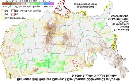
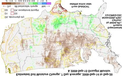
3 Background - Drought Monitoring NASA Drought Application Project PI: Jet Propulsion Laboratory (Nghiem) U.S. Geological Survey (Verdin) National Drought Mitigation Center (Wilhite) NOAA Physical Science Division (Dole) NOAA Climate Prediction Center (Le Comte) Dartmouth College (Brakenridge) Advisory Board: D. Entekhabi (MIT), D. Hall (NASA GSFC), P. Houser (George Mason U.), A. Huete (U. Arizona), G. Leshkevich (NOAA GLERL), K. Steffen (U. Colorado/CIRES), and P. Whung (USDA).


4 Background: Drought Monitoring Prototype
5 NASA Wildfire Feasibility Project Objective: Investigate the feasibility of using satellite measurements of soil moisture and vegetation; models (RAMS, FARSITE) for wildfire applications. Investigators: NASA/JPL (Nghiem, PI), Chapman University (Kafatos, Co-PI), NOAA National Weather Service, USFS. Collaborators: Los Angeles County Fire Department, Ventura County Fire Department, Orange County Fire Authority, and JPL Fire Department.

6 NASA Terra satellite image of San Diego wildfires. Red pixels indicate fire activity; black horizontal line indicates the U.S.-Mexico border. (Oct. 23, 2007 at 11:25 a.m. PDT) Image credit: NASA/MODIS Rapid Response. However, it s a little too late when things go up in smoke! We have a proactive focus: Assessment of fire danger before fires occur by enhancing: FWW, RFW, NFDRS, WFDSS

 2 0 120 110 100 90")


7 Soil Moisture Change mm Precip (a) (b) AMSR-E SMC (c) (d) % db % QSCAT SMC


8 Virga - Dry Thunderstorm NWS


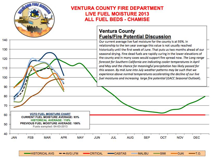
9 1/ Soil Moisture Change in 2013 and / / : Significant soil moisture increase in late January from rainwater at the onset of the growth season of vegetation. 4/ / / : Significant soil moisture increase in the 2 nd week of April from rainwater that enhanced live fuel moisture later than normal.
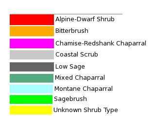
10 2013 Normal 2012 January mid April 2013 was not as severely dry as in the same period in 2012 Wet period indicated by arrow when rainwater significantly increased soil moisture, seen by Oceansat-2 scatterometer
11


12 Life Fuel Moisture Sampling Black Star Canyon, OC, April

13 NDVI from MODIS Aqua Vegetation conditions one month after January rains MODIS 2/25/2013 Riverside Moreno Valley Perris

14 NDVI from MODIS Aqua Vegetation conditions at the nominal start of fire season MODIS 5/01/2013 Riverside Moreno Valley Perris Rapid and severe dry-out of vegetation
15 NDVI from MODIS Aqua Vegetation conditions at the nominal start of fire season MODIS 5/01/2013 FIRE Riverside Moreno Valley FIRES Perris Wildfires broke out at multiple locations

16 Wildfires near Banning 5/1/2013 Fire location data from USFS

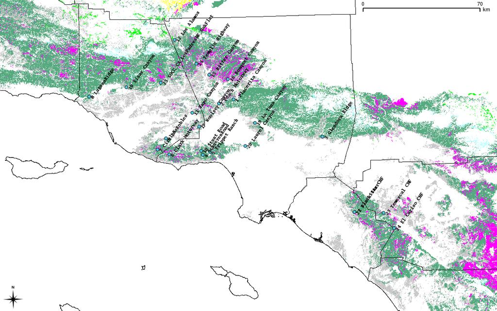
17 Can satellite replicate Life Fuel Moisture? Site information Bitter Canyon Trippet Ranch Placerita Canyon La Tuna Canyon Laurel Canyon Clark Motorway Schueren Road 5 km radius 10 km radius
18 Shrub+Coastal Scrub masking using FRAP data
19 Result of correlation with different radii All 14 sites 0.5km 1km 5km 10km 25km All Dry-transition Wet-transition Increasing trend of correlations from 0.5km to 5km and a saturation beyond 5km (blue color). (At 0.5km and 1km resolutions, seasonal cycles are less pronounced, which diminishes their correlations) Dry-transition season (Apr-Sep, red color) has higher correlation than wet-transition season (Oct-Mar, green color). Among the long-record sites, the highest correlation occurs at 25km except Placerita year record 7 sites 0.5km 1km 5km 10km 25km Bitter Placerita La Tuna Laurel Trippet Schueren Clark Average
20 Strong cross-correlations of LFM among the sites Bitter Placerita La Tuna Laurel Trippet Schueren Clark Bitter Placerita La Tuna Laurel Trippet Schueren Clark 1.0
21 5km coeff constant r Bitter Placerita La Tuna Laurel Trippet Schueren Clark Estimation of LFM by EVI (linear regression model) 25km coeff constant r Bitter Placerita La Tuna Laurel Trippet Schueren Clark
22 Decadal Characteristics LFM (%) Max_val 90% Min_val Max_date 90%_date Min_date Date of the year Max_value Min_value Max_date 90%_date Min_date 10yr mean LFM yr mean Estimation Interannual correlation * 0.10
23 Decadal Characteristics at Each Site Bitter Max_value Min_value Max_date Min_date 90%_date 10yr mean LFM yr mean Estimation Interannual correlation La Tuna Max_value Min_value Max_date Min_date 90%_date 10yr mean LFM yr mean Estimation Interannual correlation Placerita Max_value Min_value Max_date Min_date 90%_date 10yr mean LFM yr mean Estimation Interannual correlation Laurel Max_value Min_value Max_date Min_date 90%_date 10yr mean LFM yr mean Estimation Interannual correlation Trippet Max_value Min_value Max_date Min_date 90%_date 10yr mean LFM yr mean Estimation Interannual correlation Schueren Max_value Min_value Max_date Min_date 90%_date 10yr mean LFM yr mean Estimation Interannual correlation Clark Max_value Min_value Max_date Min_date 90%_date 10yr mean LFM yr mean Estimation Interannual correlation
24 Estimated LFM date Estimated LFM date Correlations with different thresholds (will be better with temperature correction; e.g., 0.73 for Schueren) 10-year dates of 75% (La Tuna) Original LFM date 100% 90% 80% 70% Bitter Placerita La Tuna Laurel Trippet Schueren Clark year dates of 75% (Laurel) Original LFM date

25 Jesusita Fire (5/2009), Farsite3 Model Will eventually use gridded winds, relative humidity, temperature, cloud cover, precip

26 Jesusita Fire with ±10% LFM (Liu)
27 Fuel Dryness Map from MODIS EVI Map by Son V. Nghiem from JPL using MODIS EVI data from Chapman University.

28 Fuel Dryness Map and USFS Fires 6/18 Carstens Fire near Yosemite National Park 6/18/2013 Map by Son V. Nghiem from JPL using MODIS EVI data from Chapman University. Fire location data from US Forest Service.
29 Summary and Conclusions Impacts of drought strongly depend not only on rainwater quantity but also on timing of water excess or deficit. Satellite data for soil moisture and vegetation can track drought conditions and impacts. Satellite data can provide quantitative assessment of drought impacts on fire danger (e.g., 2 months early in 2013). Meteorological and fire behavior models need input from satellite for full spatial and temporal characterization.
Turmoil in the Global Biosphere A View from Space
 BIOTECHNO 2011 - Keynote Venice/Mestre, Italy, May 2011 Turmoil in the Global Biosphere A View from Space S. V. Nghiem 1, P. Clemente-Colón 2, I. G. Rigor 3, D. K. Perovich 4, and G. Neumann 1 1 NASA Jet
2008 California Fire Season Outlook
 2008 California Fire Season Outlook For July through October 2008 (issued 6/25/08) 1 North Ops Concerns and Implications for Management NOPS currently in a worsening drought, due to the driest spring on
Applications/Users for Improved S2S Forecasts
 Applications/Users for Improved S2S Forecasts Nolan Doesken Colorado Climate Center Colorado State University WSWC Precipitation Forecasting Workshop June 7-9, 2016 San Diego, CA First -- A short background
Assessing Drought in Agricultural Area of central U.S. with the MODIS sensor
 Assessing Drought in Agricultural Area of central U.S. with the MODIS sensor Di Wu George Mason University Oct 17 th, 2012 Introduction: Drought is one of the major natural hazards which has devastating
Interannual variation of MODIS NDVI in Lake Taihu and its relation to climate in submerged macrophyte region
 Yale-NUIST Center on Atmospheric Environment Interannual variation of MODIS NDVI in Lake Taihu and its relation to climate in submerged macrophyte region ZhangZhen 2015.07.10 1 Outline Introduction Data
The Delaware Environmental Monitoring & Analysis Center
 The Delaware Environmental Monitoring & Analysis Center Tina Callahan Delaware Estuary Science & Environmental Summit 2013 January 27-30, 2013 What is DEMAC? Delaware Environmental Monitoring & Analysis
Statistical Forecast of the 2001 Western Wildfire Season Using Principal Components Regression. Experimental Long-Lead Forecast Bulletin
 Statistical Forecast of the 2001 Western Wildfire Season Using Principal Components Regression contributed by Anthony L. Westerling 1, Daniel R. Cayan 1,2, Alexander Gershunov 1, Michael D. Dettinger 2
Weather and climate outlooks for crop estimates
 Weather and climate outlooks for crop estimates CELC meeting 2016-04-21 ARC ISCW Observed weather data Modeled weather data Short-range forecasts Seasonal forecasts Climate change scenario data Introduction
Northwest Outlook September 2017
 Northwest Outlook September 2017 Hot and dry August August 2017 continued with the pattern established in June and July that featured a large, semipermanent ridge in the flow of the jet stream. Temperatures
MULTI-AGENCY COORDINATION SYSTEM PUBLICATION CALIFORNIA FIRE WEATHER PROGRAM RISK PREPAREDNESS GUIDE MACS 410-3
 MULTI-AGENCY COORDINATION SYSTEM PUBLICATION CALIFORNIA FIRE WEATHER PROGRAM RISK PREPAREDNESS GUIDE MACS 410-3 August 26, 2013 California Fire Weather Program Risk Preparedness Guide Table of Contents
Presentation Overview. Southwestern Climate: Past, present and future. Global Energy Balance. What is climate?
 Southwestern Climate: Past, present and future Mike Crimmins Climate Science Extension Specialist Dept. of Soil, Water, & Env. Science & Arizona Cooperative Extension The University of Arizona Presentation
The CANSAC/BLUESKY Connection
 The CANSAC/BLUESKY Connection Timothy Brown Desert Research Institute Program for Climate, Ecosystem and Fire Applications Reno, NV Partners USDA Forest Service Region 5 California Air Resources Board
The NASA Soil Moisture Active Passive Mission (SMAP) Status and Early Results
 Status and Early Results") 20154 California Institute of Technology. Government sponsorship acknowledged. National Aeronautics and Space Administration The NASA Soil Moisture Active Passive Mission (SMAP) Status and Early Results
20154 California Institute of Technology. Government sponsorship acknowledged. National Aeronautics and Space Administration The NASA Soil Moisture Active Passive Mission (SMAP) Status and Early Results
Assimilating terrestrial remote sensing data into carbon models: Some issues
 University of Oklahoma Oct. 22-24, 2007 Assimilating terrestrial remote sensing data into carbon models: Some issues Shunlin Liang Department of Geography University of Maryland at College Park, USA Sliang@geog.umd.edu,
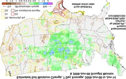
NIDIS Intermountain West Drought Early Warning System August 8, 2017
 NIDIS Drought and Water Assessment 8/8/17, 4:43 PM NIDIS Intermountain West Drought Early Warning System August 8, 2017 Precipitation The images above use daily precipitation statistics from NWS COOP,
Current and Future Impacts of Wildfires on PM 2.5, Health, and Policy in the Rocky Mountains
 Current and Future Impacts of Wildfires on PM 2.5, Health, and Policy in the Rocky Mountains Yang Liu, Ph.D. STAR Grants Kick-off Meeting Research Triangle Park, NC April 5, 2017 Motivation The Rocky Mountains
NIDIS Intermountain West Drought Early Warning System July 18, 2017
 NIDIS Drought and Water Assessment NIDIS Intermountain West Drought Early Warning System July 18, 2017 Precipitation The images above use daily precipitation statistics from NWS COOP, CoCoRaHS, and CoAgMet
YACT (Yet Another Climate Tool)? The SPI Explorer
? The SPI Explorer") YACT (Yet Another Climate Tool)? The SPI Explorer Mike Crimmins Assoc. Professor/Extension Specialist Dept. of Soil, Water, & Environmental Science The University of Arizona Yes, another climate tool for
YACT (Yet Another Climate Tool)? The SPI Explorer Mike Crimmins Assoc. Professor/Extension Specialist Dept. of Soil, Water, & Environmental Science The University of Arizona Yes, another climate tool for
Long-lead prediction of the 2015 fire and haze episode in Indonesia
 Long-lead prediction of the 2015 fire and haze episode in Indonesia Robert Field 1,2 Dilshad Shawki 3, Michael Tippett 2, Bambang Hero Saharjo 4, Israr Albar 5, Dwi Atmoko 6, Apostolos Voulgarakis 1 1.
Arizona Climate Summary May 2012
 Arizona Climate Summary May 2012 Summary of conditions for April 2012 April 2012 Temperature and Precipitation Summary April 1 st 16 th : Although April began with another low pressure system sweeping
DROUGHT ASSESSMENT USING SATELLITE DERIVED METEOROLOGICAL PARAMETERS AND NDVI IN POTOHAR REGION
 DROUGHT ASSESSMENT USING SATELLITE DERIVED METEOROLOGICAL PARAMETERS AND NDVI IN POTOHAR REGION Researcher: Saad-ul-Haque Supervisor: Dr. Badar Ghauri Department of RS & GISc Institute of Space Technology
Interpretation of Polar-orbiting Satellite Observations. Atmospheric Instrumentation
 Interpretation of Polar-orbiting Satellite Observations Outline Polar-Orbiting Observations: Review of Polar-Orbiting Satellite Systems Overview of Currently Active Satellites / Sensors Overview of Sensor
Global Satellite Products & Services for Agricultural and Vegetation Health
 Global Satellite Products & Services for Agricultural and Vegetation Health Presented at the WMO Expert Meeting on National Early Warning System for Agricultural Weather Management George Mason University
National Wildland Significant Fire Potential Outlook
 National Wildland Significant Fire Potential Outlook National Interagency Fire Center Predictive Services Issued: April 1, 2008 Next Issue: May 1, 2008 Wildland Fire Outlook April 2008 through July 2008
JPSS GEONETCAST REQUIREMENTS DISCUSSION
 Joint Polar Satellite System (JPSS) JPSS GEONETCAST REQUIREMENTS DISCUSSION Mitch Goldberg Program Scientist Joint Polar Satellite System National Environmental Satellite, Data, and Information Service
2011 National Seasonal Assessment Workshop for the Eastern, Southern, & Southwest Geographic Areas
 2011 National Seasonal Assessment Workshop for the Eastern, Southern, & Southwest Geographic Areas On January 11-13, 2011, wildland fire, weather, and climate met virtually for the ninth annual National
Precipitation. Standardized Precipitation Index. NIDIS Intermountain West Drought Early Warning System September 5, 2017
 9/6/2017 NIDIS Drought and Water Assessment NIDIS Intermountain West Drought Early Warning System September 5, 2017 Precipitation The images above use daily precipitation statistics from NWS COOP, CoCoRaHS,
Seasonal and interannual relations between precipitation, soil moisture and vegetation in the North American monsoon region
 Seasonal and interannual relations between precipitation, soil moisture and vegetation in the North American monsoon region Luis A. Mendez-Barroso 1, Enrique R. Vivoni 1, Christopher J. Watts 2 and Julio
North Central U.S. Climate Summary and Outlook Webinar July 21, 2016
 North Central U.S. Climate Summary and Outlook Webinar July 21, 2016 Stuart Foster State Climatologist for Kentucky Department of Geography and Geology Western Kentucky University Stuart.foster@wku.edu
Arizona Drought Monitoring Sensitivity and Verification Analyses
 Arizona Drought Monitoring Sensitivity and Verification Analyses A Water Sustainability Institute, Technology and Research Initiative Fund Project Christopher L. Castro, Francina Dominguez, Stephen Bieda
Evaluation of a MODIS Triangle-based Algorithm for Improving ET Estimates in the Northern Sierra Nevada Mountain Range
 Evaluation of a MODIS Triangle-based Algorithm for Improving ET Estimates in the Northern Sierra Nevada Mountain Range Kyle R. Knipper 1, Alicia M. Kinoshita 2, and Terri S. Hogue 1 January 5 th, 2015
Recent Advances in Observations of Land Cover and Land Use Change and Impacts from Multi-Sourced Data
 International Meeting on Land Use and Emissions in South/Southeast Asia - Ho Chi Minh City, Vietnam, 17-19 October, 2016 Recent Advances in Observations of Land Cover and Land Use Change and Impacts from
Midwest and Great Plains Climate and Drought Update
 Midwest and Great Plains Climate and Drought Update June 20,2013 Laura Edwards Climate Field Specialist Laura.edwards@sdstate.edu 605-626-2870 2012 Board of Regents, South Dakota State University General
Enhancement of the U.S. Drought Monitor Through the Integration of NASA Vegetation Index Imagery
 Enhancement of the U.S. Drought Monitor Through the Integration of NASA Vegetation Index Imagery Project and Related Activities at USGS/EROS Jim Verdin, Jesslyn Brown, Yingxin Gu, Gail Schmidt, Troy McVay
Sierra Weather and Climate Update
 Sierra Weather and Climate Update 2014-15 Kelly Redmond Western Regional Climate Center Desert Research Institute Reno Nevada Yosemite Hydroclimate Workshop Yosemite Valley, 2015 October 8-9 Percent of
SEPTEMBER 2013 REVIEW
 Monthly Long Range Weather Commentary Issued: October 21, 2013 Steven A. Root, CCM, President/CEO sroot@weatherbank.com SEPTEMBER 2013 REVIEW Climate Highlights The Month in Review The average temperature
The North American Drought Monitor - The Canadian Perspective -
 The North American Drought Monitor - The Canadian Perspective - Trevor Hadwen National Agroclimate Information Service AAFC-PFRA, Regina Canmore, Alberta March 16-18, 2008 Background The NADM is a cooperative
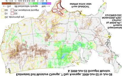
NIDIS Intermountain West Drought Early Warning System May 23, 2017
 NIDIS Drought and Water Assessment NIDIS Intermountain West Drought Early Warning System May 23, 2017 Precipitation The images above use daily precipitation statistics from NWS COOP, CoCoRaHS, and CoAgMet
Current and Upcoming NASA Hurricane Measurement Missions National Hurricane Conference
 NASA Science Mission Directorate Earth Science Division Applied Sciences Program Current and Upcoming NASA Hurricane Measurement Missions National Hurricane Conference April 18, 2017 Formulation Implementation
National Wildland Significant Fire Potential Outlook
 National Wildland Significant Fire Potential Outlook National Interagency Fire Center Predictive Services Issued: September, 2007 Wildland Fire Outlook September through December 2007 Significant fire
Climate Change and Arizona s Rangelands: Management Challenges and Opportunities
 Climate Change and Arizona s Rangelands: Management Challenges and Opportunities Mike Crimmins Climate Science Extension Specialist Dept. of Soil, Water, & Env. Science & Arizona Cooperative Extension
Extremes Events in Climate Change Projections Jana Sillmann
 Extremes Events in Climate Change Projections Jana Sillmann Max Planck Institute for Meteorology International Max Planck Research School on Earth System Modeling Temperature distribution IPCC (2001) Outline
Accomplishments and Deliverables
 ANNUAL REPORT 2015 Background In July 2002, the FIRESCOPE California Wildfire Agencies (CWA) approved a charter leading to the formation of the California and Nevada Smoke and Air Committee (CANSAC). The
Climate Analysis of the 2000 Fire Season
 Program for Climate, Ecosystem and Fire Applications.......... Climate Analysis of the 2000 Fire Season Timothy J. Brown Beth L. Hall. Division of Atmospheric Sciences CEFA Report 01-02 August 2001 Climate
The SE US Drought of 2016 and Public Health Impacts of Wildfire Smoke
 The SE US Drought of 2016 and Public Health Impacts of Wildfire Smoke Chip Konrad Carolinas RISA NOAA Southeast Regional Climate Center University of North Carolina at Chapel Hill Outline Evolution of
HIGH RESOLUTION RAPID REFRESH COUPLED WITH SMOKE (HRRR- SMOKE): REAL-TIME AIR QUALITY MODELING SYSTEM AND ITS APPLICATION TO CASE STUDIES
: REAL-TIME AIR QUALITY MODELING SYSTEM AND ITS APPLICATION TO CASE STUDIES") HIGH RESOLUTION RAPID REFRESH COUPLED WITH SMOKE (HRRR- SMOKE): REAL-TIME AIR QUALITY MODELING SYSTEM AND ITS APPLICATION TO CASE STUDIES Ravan Ahmadov 1,2 (ravan.ahmadov@noaa.gov) Acknowledgement: G.
HIGH RESOLUTION RAPID REFRESH COUPLED WITH SMOKE (HRRR- SMOKE): REAL-TIME AIR QUALITY MODELING SYSTEM AND ITS APPLICATION TO CASE STUDIES Ravan Ahmadov 1,2 (ravan.ahmadov@noaa.gov) Acknowledgement: G.
Critical live fuel moisture in chaparral ecosystems: A threshold for fire activity and its relationship to antecedent precipitation
 Critical live fuel moisture in chaparral ecosystems: A threshold for fire activity and its relationship to antecedent precipitation Philip E. Dennison 1 and Max A. Moritz 2 1 Department of Geography and
2009 Progress Report To The National Aeronautics and Space Administration NASA Energy and Water Cycle Study (NEWS) Program
 Program") 2009 Progress Report To The National Aeronautics and Space Administration NASA Energy and Water Cycle Study (NEWS) Program Proposal Title: Grant Number: PI: The Challenges of Utilizing Satellite Precipitation
2009 Progress Report To The National Aeronautics and Space Administration NASA Energy and Water Cycle Study (NEWS) Program Proposal Title: Grant Number: PI: The Challenges of Utilizing Satellite Precipitation
Oregon Water Conditions Report April 17, 2017
 Oregon Water Conditions Report April 17, 2017 Mountain snowpack continues to maintain significant levels for mid-april. By late March, statewide snowpack had declined to 118 percent of normal after starting
NIDIS Intermountain West Drought Early Warning System May 1, 2018
 NIDIS Intermountain West Drought Early Warning System May 1, 2018 Precipitation The images above use daily precipitation statistics from NWS COOP, CoCoRaHS, and CoAgMet stations. From top to bottom, and
Drought and Climate Extremes Indices for the North American Drought Monitor and North America Climate Extremes Monitoring System. Richard R. Heim Jr.
 Drought and Climate Extremes Indices for the North American Drought Monitor and North America Climate Extremes Monitoring System Richard R. Heim Jr. NOAA/NESDIS/National Climatic Data Center Asheville,
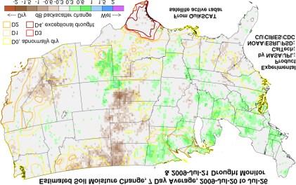
NIDIS Intermountain West Regional Drought Early Warning System February 7, 2017
 NIDIS Drought and Water Assessment NIDIS Intermountain West Regional Drought Early Warning System February 7, 2017 Precipitation The images above use daily precipitation statistics from NWS COOP, CoCoRaHS,
El Nino 2015 in South Sudan: Impacts and Perspectives. Raul Cumba
 El Nino 2015 in South Sudan: Impacts and Perspectives Raul Cumba El Nino 2015-2016 The El Nino Event of 2015-2016 The 2015/16 El Nino Event Officially declared in March 2015 Now approaching peak intensity
Long-term global time series of MODIS and VIIRS SSTs
 Long-term global time series of MODIS and VIIRS SSTs Peter J. Minnett, Katherine Kilpatrick, Guillermo Podestá, Yang Liu, Elizabeth Williams, Susan Walsh, Goshka Szczodrak, and Miguel Angel Izaguirre Ocean
Monthly Long Range Weather Commentary Issued: APRIL 25, 2016 Steven A. Root, CCM, Chief Analytics Officer, Sr. VP, sales
 Monthly Long Range Weather Commentary Issued: APRIL 25, 2016 Steven A. Root, CCM, Chief Analytics Officer, Sr. VP, sales sroot@weatherbank.com MARCH 2016 Climate Highlights The Month in Review The March
Climate Impacts to Southwest Water Sector. Dr. Dave DuBois New Mexico State Climatologist
 Climate Impacts to Southwest Water Sector Dr. Dave DuBois New Mexico State Climatologist Presented at EPA Extreme Events and Climate Adaptation Planning Workshop June 3, 2015 Water Year Precip. % of Average
UPPLEMENT A COMPARISON OF THE EARLY TWENTY-FIRST CENTURY DROUGHT IN THE UNITED STATES TO THE 1930S AND 1950S DROUGHT EPISODES
 UPPLEMENT A COMPARISON OF THE EARLY TWENTY-FIRST CENTURY DROUGHT IN THE UNITED STATES TO THE 1930S AND 1950S DROUGHT EPISODES Richard R. Heim Jr. This document is a supplement to A Comparison of the Early
Minnesota s Climatic Conditions, Outlook, and Impacts on Agriculture. Today. 1. The weather and climate of 2017 to date
 Minnesota s Climatic Conditions, Outlook, and Impacts on Agriculture Kenny Blumenfeld, State Climatology Office Crop Insurance Conference, Sep 13, 2017 Today 1. The weather and climate of 2017 to date
NATIONAL WEATHER SERVICE
 January 2016 February 9, 2016 This was a dry month across the HSA despite one large and several smaller snowfalls. Most locations ended up 1-2 inches below normal for the month. The driest locations at
Applications of yield monitoring systems and agricultural statistics in agricultural (re)insurance
insurance") Image: used under license from shutterstock.com Applications of yield monitoring systems and agricultural statistics in agricultural (re)insurance 18 October 2018 Ernst Bedacht Agenda Introduction 1. Munich
Image: used under license from shutterstock.com Applications of yield monitoring systems and agricultural statistics in agricultural (re)insurance 18 October 2018 Ernst Bedacht Agenda Introduction 1. Munich
Validating a Satellite Microwave Remote Sensing Based Global Record of Daily Landscape Freeze- Thaw Dynamics
 University of Montana ScholarWorks at University of Montana Numerical Terradynamic Simulation Group Publications Numerical Terradynamic Simulation Group 2012 Validating a Satellite Microwave Remote Sensing
Fire Weather Monitoring and Predictability in the Southeast
 Fire Weather Monitoring and Predictability in the Southeast Corey Davis October 9, 2014 Photo: Pains Bay fire in 2011 (courtesy Donnie Harris, NCFWS) Outline Fire risk monitoring Fire risk climatology
Ganbat.B, Agro meteorology Section
 NATIONAL AGENCY FOR METEOROLOGY, HYDROLOGY AND ENVIRONMENT MONITORING OF MONGOLIA Ganbat.B, Agro meteorology Section OF INSTITUTE OF METEOROLOGY AND HYDROLOGY 2009 YEAR Location Climate Northern Asia,
Climate Variability and El Niño
 Climate Variability and El Niño David F. Zierden Florida State Climatologist Center for Ocean Atmospheric Prediction Studies The Florida State University UF IFAS Extenstion IST January 17, 2017 The El
Using Temperature and Dew Point to Aid Forecasting Springtime Radiational Frost and/or Freezing Temperatures in the NWS La Crosse Service Area
 Using Temperature and Dew Point to Aid Forecasting Springtime Radiational Frost and/or Freezing Temperatures in the NWS La Crosse Service Area WFO La Crosse Climatology Series #21 The formation of radiational
NIDIS Intermountain West Drought Early Warning System February 12, 2019
 NIDIS Intermountain West Drought Early Warning System February 12, 2019 Precipitation The images above use daily precipitation statistics from NWS COOP, CoCoRaHS, and CoAgMet stations. From top to bottom,
Christopher L. Castro Department of Atmospheric Sciences University of Arizona
 Spatiotemporal Variability and Covariability of Temperature, Precipitation, Soil Moisture, and Vegetation in North America for Regional Climate Model Applications Christopher L. Castro Department of Atmospheric
This article appeared in a journal published by Elsevier. The attached copy is furnished to the author for internal non-commercial research and
 This article appeared in a journal published by Elsevier. The attached copy is furnished to the author for internal non-commercial research and education use, including for instruction at the authors institution
Monitoring daily evapotranspiration in the Alps exploiting Sentinel-2 and meteorological data
 Monitoring daily evapotranspiration in the Alps exploiting Sentinel-2 and meteorological data M. Castelli, S. Asam, A. Jacob, M. Zebisch, and C. Notarnicola Institute for Earth Observation, Eurac Research,
Westmap: The Western Climate Mapping Initiative An Update
 Westmap: The Western Climate Mapping Initiative An Update Andrew Comrie 1, Kelly Redmond 2, Mary Glueck 1, Hauss Reinbold 3, Chris Daly 4 1 University of Arizona, 2 DRI / Western Regional Climate Center
VIIRS Radiometric Calibration for Reflective Solar Bands: Antarctic Dome C Site and Simultaneous Nadir Overpass Observations
 VIIRS Radiometric Calibration for Reflective Solar Bands: Antarctic Dome C Site and Simultaneous Nadir Overpass Observations Slawomir Blonski, * Changyong Cao, Sirish Uprety, ** and Xi Shao * NOAA NESDIS
Forecasting Challenges
 Forecasting Challenges 2017-18 Alex Tardy- NWS San Diego Alexander.Tardy@noaa.gov CW3E meetings April 2018 Atmospheric Rivers Climate Forecast System by NOAA 100-h fuel moisture all-time low for South
Improving Numerical Weather Forecasting for Ghana/West Africa
 Improving Numerical Weather Forecasting for Ghana/West Africa Amos T. Kabo-bah, PhD Head, Earth Observation Research and Innovation Centre University of Energy and Natural Resources Sunyani Ghana/West
NIDIS Intermountain West Drought Early Warning System January 22, 2019
 NIDIS Drought and Water Assessment NIDIS Intermountain West Drought Early Warning System January 22, 2019 Precipitation The images above use daily precipitation statistics from NWS COOP, CoCoRaHS, and
PYROGEOGRAPHY OF THE IBERIAN PENINSULA
 PYROGEOGRAPHY OF THE IBERIAN PENINSULA Teresa J. Calado (1), Carlos C. DaCamara (1), Sílvia A. Nunes (1), Sofia L. Ermida (1) and Isabel F. Trigo (1,2) (1) Instituto Dom Luiz, Universidade de Lisboa, Lisboa,
CoCoRaHS Monitoring Colorado s s Water Resources through Community Collaborations
 CoCoRaHS Monitoring Colorado s s Water Resources through Community Collaborations Nolan Doesken Colorado Climate Center Atmospheric Science Department Colorado State University Presented at Sustaining
Flux Tower Data Quality Analysis. Dea Doklestic
 Flux Tower Data Quality Analysis Dea Doklestic Motivation North American Monsoon (NAM) Seasonal large scale reversal of atmospheric circulation Occurs during the summer months due to a large temperature
Analysing Land Surface Emissivity with Multispectral Thermal Infrared Data
 2nd Workshop on Remote Sensing and Modeling of Surface Properties 9-11 June 2009, Météo France, Toulouse, France Analysing Land Surface Emissivity with Multispectral Thermal Infrared Data Maria Mira, Thomas
Fire Predictions for Southern California By: Romuel-Dave Chaves, Jason Collins, and Megan Parry
 Fire Predictions for Southern California By: Romuel-Dave Chaves, Jason Collins, and Megan Parry Abstract: Southern California wildfires are increasingly destructive and it is widely held that the problem
Climate Variability and Change, and Southern California Water San Gabriel Valley Water Forum, Pomona, CA, October 2, 2014
 Climate Variability and Change, and Southern California Water San Gabriel Valley Water Forum, Pomona, CA, October 2, 2014 Dan Cayan (with Mike Dettinger, David Pierce, Suraj Polade, Mary Tyree, Alexander
Disseminating Fire Weather/Fire Danger Forecasts through a Web GIS. Andrew Wilson Riverside Fire Lab USDA Forest Service
 Disseminating Fire Weather/Fire Danger Forecasts through a Web GIS Andrew Wilson Riverside Fire Lab USDA Forest Service Hawaii Fire Danger System Supporters Hawaii Department of Forestry & Wildlife Pacific
Water Year 2019 Wet or Dry?? Improving Sub-seasonal to Seasonal Precipitation Forecasting Jeanine Jones, Department of Water Resources
 Water Year 2019 Wet or Dry?? Improving Sub-seasonal to Seasonal Precipitation Forecasting Jeanine Jones, Department of Water Resources Sub-Seasonal to Seasonal (S2S) Precipitation Forecasting Operational
Influence of the Northern Pacific Jet on California hydroclimate and wildfire regimes over the last 500 years
 Influence of the Northern Pacific Jet on California hydroclimate and wildfire regimes over the last 500 years Valerie Trouet UQAT 25 October 2016 1. Land-use modulation of Sierra Nevada fire regimes 2.
NIDIS Intermountain West Drought Early Warning System September 4, 2018
 NIDIS Drought and Water Assessment NIDIS Intermountain West Drought Early Warning System September 4, 2018 Precipitation The images above use daily precipitation statistics from NWS COOP, CoCoRaHS, and
A Review of the 2007 Water Year in Colorado
 A Review of the 2007 Water Year in Colorado Nolan Doesken Colorado Climate Center, CSU Mike Gillespie Snow Survey Division, USDA, NRCS Presented at the 28 th Annual AGU Hydrology Days, March 26, 2008,
Colorado s 2003 Moisture Outlook
 Colorado s 2003 Moisture Outlook Nolan Doesken and Roger Pielke, Sr. Colorado Climate Center Prepared by Tara Green and Odie Bliss http://climate.atmos.colostate.edu How we got into this drought! Fort
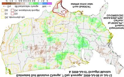
NIDIS Intermountain West Drought Early Warning System April 18, 2017
 1 of 11 4/18/2017 3:42 PM Precipitation NIDIS Intermountain West Drought Early Warning System April 18, 2017 The images above use daily precipitation statistics from NWS COOP, CoCoRaHS, and CoAgMet stations.
GCOM-W1 now on the A-Train
 GCOM-W1 now on the A-Train GCOM-W1 Global Change Observation Mission-Water Taikan Oki, K. Imaoka, and M. Kachi JAXA/EORC (& IIS/The University of Tokyo) Mini-Workshop on A-Train Science, March 8 th, 2013
CHAPTER-11 CLIMATE AND RAINFALL
 CHAPTER-11 CLIMATE AND RAINFALL 2.1 Climate Climate in a narrow sense is usually defined as the "average weather", or more rigorously, as the statistical description in terms of the mean and variability
Southwest Drought Webinar. Becky Bolinger, Assistant State Climatologist Colorado Climate Center June 25, 2018
 Southwest Drought Webinar Becky Bolinger, Assistant State Climatologist Colorado Climate Center June 25, 2018 COLORADO CLIMATE CENTER Current Drought U.S. Drought Monitor Drought evolution COLORADO CLIMATE
ANNUAL CLIMATE REPORT 2016 SRI LANKA
 ANNUAL CLIMATE REPORT 2016 SRI LANKA Foundation for Environment, Climate and Technology C/o Mahaweli Authority of Sri Lanka, Digana Village, Rajawella, Kandy, KY 20180, Sri Lanka Citation Lokuhetti, R.,
Customizable Drought Climate Service for supporting different end users needs
 1 Customizable Drought Climate Service for supporting different end users needs Ramona MAGNO, T. De Filippis, E. Di Giuseppe, M. Pasqui, E. Rapisardi, L. Rocchi (IBIMET-CNR; LaMMA Consortium) 1 Congresso
Southern California Edison Wildfire Mitigation & Grid Resiliency
 Southern California Edison Wildfire Mitigation & Grid Resiliency California State Legislative Conference Committee on Wildfire Preparedness and Response August 7, 2018 CALIFORNIA S WILDFIRE RISK Year-Round
January 25, Summary
 January 25, 2013 Summary Precipitation since the December 17, 2012, Drought Update has been slightly below average in parts of central and northern Illinois and above average in southern Illinois. Soil
High Resolution Indicators for Local Drought Monitoring
 High Resolution Indicators for Local Drought Monitoring REBECCA CUMBIE, STATE CLIMATE OFFICE OF NC, NCSU Monitoring Drought Multiple indicators, multiple sources Local detail important 1 Point-Based Climate-Division
METEOSAT SECOND GENERATION DATA FOR ASSESSMENT OF SURFACE MOISTURE STATUS
 METEOSAT SECOND GENERATION DATA FOR ASSESSMENT OF SURFACE MOISTURE STATUS Simon Stisen (1), Inge Sandholt (1), Rasmus Fensholt (1) (1) Institute of Geography, University of Copenhagen, Oestervoldgade 10,
Drought Impacts in the Southern Great Plains. Mark Shafer University of Oklahoma Norman, OK
 Drought Impacts in the Southern Great Plains Mark Shafer University of Oklahoma Norman, OK Causes of Drought: Large-Scale, Stationary High Pressure Air rotates clockwise around high pressure steers storms
Satellites, Weather and Climate Module 40: Agriculture & forestry in a changing climate
 Satellites, Weather and Climate Module 40: Agriculture & forestry in a changing climate http://www.youtube.com/watch?v=ksnblyhrru8 http://1.bp.blogspot.com/-lemica8b_h4/ufln63qlxdi/aaaaaaaacym/xc3htckubeg/s1600/animated.gif
Some NOAA Products that Address PSTG Satellite Observing Requirements. Jeff Key NOAA/NESDIS Madison, Wisconsin USA
 Some NOAA Products that Address PSTG Satellite Observing Requirements Jeff Key NOAA/NESDIS Madison, Wisconsin USA WMO Polar Space Task Group, 4 th meeting, Greenbelt, 30 September 2014 Relevant Missions
RETRIEVAL OF SOIL MOISTURE OVER SOUTH AMERICA DERIVED FROM MICROWAVE OBSERVATIONS
 2nd Workshop on Remote Sensing and Modeling of Surface Properties 9-11 June 2009, Toulouse, France Météo France Centre International de Conférences RETRIEVAL OF SOIL MOISTURE OVER SOUTH AMERICA DERIVED