The CANSAC/BLUESKY Connection
|
|
|
- Shawn Wade
- 5 years ago
- Views:
Transcription


1 The CANSAC/BLUESKY Connection Timothy Brown Desert Research Institute Program for Climate, Ecosystem and Fire Applications Reno, NV


2
3 Partners USDA Forest Service Region 5 California Air Resources Board USDA Forest Service Pacific Southwest Research Station U.S. Fish and Wildlife Service Pacific Region National Park Service Bureau of Land Management California State Office Bureau of Land Management Nevada State Office California Department of Forestry and Fire Protection San Joaquin Valley Air Pollution Control District Los Angeles County Fire Department
4 CANSAC Structure Board of Directors 9 members Operational and Applications Group 7 members Technical Advisory Group 5 members
5 CANSAC as a Science Decision-Maker Partnership Partnership structure Organizational design Availability of resources CANSAC management Leadership Progress
6 CEFA-CANSAC Personnel Domagoj Podnar - Systems administration/operations and Development Manager Hauss Reinbold - Web and graphics Tesfamichael Ghidey - Ph.D. student Crystal Kolden - Outreach

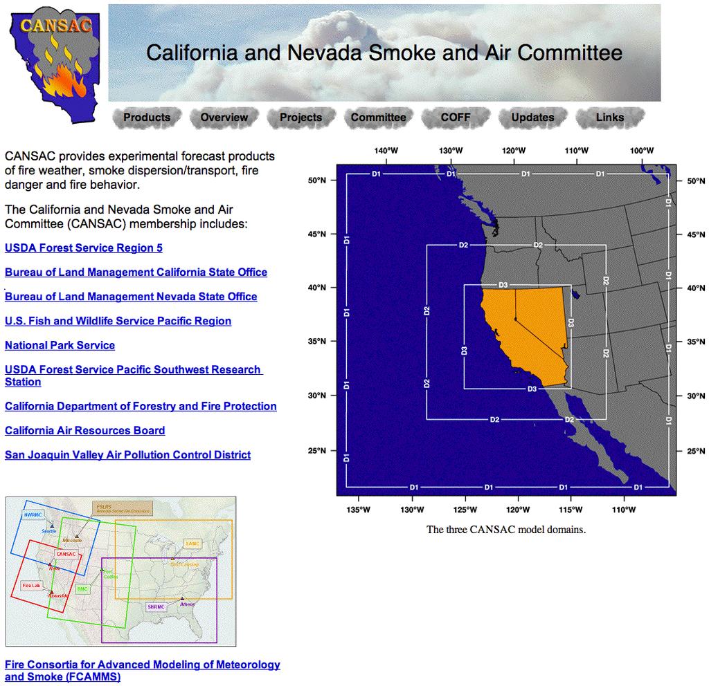
 domain")


7 MM5 Configuration Coarsest domain 36 km, nested domain 12 km, and innermost (Nevada/California) domain 4 km horizontal grid spacing and 32 sigma (vertical) levels. Initialized at 00Z and 12Z Forecast length: 72 hr for domains 1 and 2, and 60 hr for domain 3 Sample products
8

9 BLUESKY BACKGROUND BlueSky is a real-time smoke forecasting system that is used to predict surface smoke concentrations (PM2.5) from prescribed fire, agricultural burns, and wildfires. The BlueSky smoke forecasting system was developed by the USDA Forest Service in cooperation with the US EPA and funded by the National Fire Plan. It is currently being implemented and evaluated across the nation by the members of FCAMMS.
10 BlueSky Modeling Framework Fire Characteristics Meteorology Area burned CANSAC MM5 outputs Fuel moisture Winds/Temps/Moisture Fuel loadings 12 and 4 km domains Fire location 72 and 60 hour (-12 hr spin up) forecast Fire ignition time Emissions EPM emissions model Fuel consumption Variable rate emissions PM10, PM2.5,CO, CO2, CH4 Smoke Dispersion&Transport CALPUFF/CALMET modeling system PM2.5 concentrations Display PAVE visualization package NCL images (in progress) Loops and hourly concentrations of PM2.5
11 BlueSky Framework WEATHER FORECAST MODEL OUTPUT MM5 WRF MET INTERPRETER CALMM5 HYSPLIT TRAJECTORIES DISPERSION CALPUFF HYSPLIT EMISSIONS EPM FEPS BURNUP Idealized profile CONSUMPTION CONSUME 1.02 CONSUME 3 BURNUP SMOKE TRAJECTORY & CONCENTRATION PREDICTIONS FIRE INFORMATION REPORTING SYSTEMS FUEL LOADING FCCS Hardy (West) NFDRS Wildfire ICS 209 FASTRACS RAZU Manual Other Framework is Modular Open-sourced Portable
, and private manually entered burn information.")
12 Fire Characteristics (I) Information to derive fire characteristics is obtained from the burn reporting systems. These can be multi-agency tracking systems such as FASTRACS in the Pacific Northwest, PFIRS in California, wildfire 209 reports (NIFC), and private manually entered burn information. When the fuel loadings are not provided, the BlueSky system has three default fuel loadings look-up tables to employ: 1-km resolution fuel loadings mapping available for the western US (Hardy et al., 1998). Fuel Characteristics Classification System (FCSS) at 1-km resolution ( National Fire Danger Rating System (NFDRS) at 1-km resolution.

13 Emissions (I) Fuel consumption and emissions are calculated using the Emissions Production Model (EPM)/Consume v1.02 Consume is a fuel consumption model that computes the total amount of fuel consumed by a fire EPM is a model that predicts the time rate of fuel consumption and emissions from wildland biomass burns. Hourly emission rates of PM10, PM2.5, PM, CO, CO2, CH4 and heat release are obtained from this system.

14 Meteorology Meteorology driving the BlueSky system is obtained from MM5 forecasts A preprocessor, CALMM5, is used to extract the meteorological fields used in CALMET Horizontal and vertical winds, temps, pressure, humidity, and vapor, cloud, rain, snow, ice mixing ratios

15 Smoke Dispersion and Transport The BlueSky system incorporates the CALMET/CALPUFF system to predict smoke dispersion and transport CALPUFF is a multi-layer, multi-species non-steady state Lagrangian puff dispersion model which can simulate the time and space varying pollutant transport, transformation and removal CALMET is a diagnostic meteorological model that calculates the three dimensional winds and temperatures along with microphysical parameters such as surface characteristics, dispersion parameters, and mixing heights to be used by CALPUFF dispersion model

16 Burn Information The CANSAC BlueSky system is fed by the Wildfire 209 reports and the CANSAC webbased manual prescribed burn information system PFIRS will begin to feed data into the CANSAC system in spring 2008
 concentration predictions are obtained on the nested (12 km) and innermost (4 km) MM5 domains Forecast length 72hr: Accomplished burns are reprocessed 4-6 days back in order to")
17 BlueSky Simulations The BlueSky simulations are performed daily using the MM5 output initialized at 0Z These simulations start at midnight Surface smoke (PM2.5) concentration predictions are obtained on the nested (12 km) and innermost (4 km) MM5 domains Forecast length 72hr: Accomplished burns are reprocessed 4-6 days back in order to account for carryover smoke


18 Plume Rise Fires are currently modeled as single plumes, lofting smoke unrealistically high and lowering ground impacts Modeled In reality, fires are made of many burning areas lofting smoke to various heights Reality 18

19 August - September
")
20 SMARTFIRE satellite data feed - better location & timing (& fuels) 20

21 21 S. Raffuse, Sonoma Tech
Development of Operational Air Quality MM5-MOS Equations for the San Joaquin Valley Air Pollution Control District
 Program for Climate, Ecosystem and Fire Applications Development of Operational Air Quality MM5-MOS Equations for the San Joaquin Valley Air Pollution Control District Final Report Hauss J. Reinbold Timothy
CANSAC-CEFA Operations and Products for the California and Nevada Smoke and Air Committee
 Program for Climate, Ecosystem and Fire Applications CANSAC-CEFA Operations and Products for the California and Nevada Smoke and Air Committee Annual Report Timothy J. Brown Julide Kahyaoglu-Koracin Division
Accomplishments and Deliverables
 ANNUAL REPORT 2015 Background In July 2002, the FIRESCOPE California Wildfire Agencies (CWA) approved a charter leading to the formation of the California and Nevada Smoke and Air Committee (CANSAC). The
S. A. Ferguson,* USDA-Forest Service, Pacific Northwest Research Station, Seattle, Washington
 6.7 AUTOMATED, REAL-TIME PREDICTIONS OF CUMULATIVE SMOKE IMPACTS FROM PRESCRIBED FOREST AND AGRICULTURAL FIRES S. A. Ferguson,* USDA-Forest Service, Pacific Northwest Research Station, Seattle, Washington
The Tahoe Climate Information Management System (Tahoeclim)
") The Tahoe Climate Information Management System (Tahoeclim) Final Report August 2016 Kelly T. Redmond 1, Geoff Schladow 2 1 Desert Research Institute Reno, NV 2 Tahoe Environmental Research Center, UC
The Tahoe Climate Information Management System (Tahoeclim) Final Report August 2016 Kelly T. Redmond 1, Geoff Schladow 2 1 Desert Research Institute Reno, NV 2 Tahoe Environmental Research Center, UC
Disseminating Fire Weather/Fire Danger Forecasts through a Web GIS. Andrew Wilson Riverside Fire Lab USDA Forest Service
 Disseminating Fire Weather/Fire Danger Forecasts through a Web GIS Andrew Wilson Riverside Fire Lab USDA Forest Service Hawaii Fire Danger System Supporters Hawaii Department of Forestry & Wildlife Pacific
Natural Event Documentation
 ADDENDUM Natural Event Documentation Corcoran, Oildale and Bakersfield, California September 22, 2006 San Joaquin Valley Unified Air Pollution Control District May 23, 2007 Natural Event Documentation
The Impacts of Wildfire Smoke and the Western Canada BlueSky Wildfire Smoke Forecasting System
 The Impacts of Wildfire Smoke and the Western Canada BlueSky Wildfire Smoke Forecasting System Wildland Fire Canada Conference October 2012 Steve Sakiyama, British Columbia Ministry of Environment Steve.Sakiyama@gov.bc.ca
Development of U.S. Operational Fire Danger 15-Day Forecasts
 Program for Climate, Ecosystem and Fire Applications Development of U.S. Operational Fire Danger 15-Day Forecasts Beth L. Hall Timothy J. Brown Larry S. Bradshaw Division of Atmospheric Sciences. CEFA
Addendum to the. Submitted to U.S. EPA Region 9 March 17, Prepared by:
 Addendum to the Exceptional Events Demonstration for 2015 Ozone Exceedance in Washoe County from the 2015 California Wildfires August 21, 2015 Submitted to U.S. EPA Region 9 March 17, 2017 Prepared by:
A PRESCRIBED BURN DECISION SUPPORT SYSTEM FOR THE KANSAS FLINT HILLS REGION
 A PRESCRIBED BURN DECISION SUPPORT SYSTEM FOR THE KANSAS FLINT HILLS REGION Kenneth Craig*, Clinton MacDonald, Neil Wheeler, Alan Healy, and Patrick Zahn Sonoma Technology, Inc., Petaluma, California,
The Kentucky Mesonet: Entering a New Phase
 The Kentucky Mesonet: Entering a New Phase Stuart A. Foster State Climatologist Kentucky Climate Center Western Kentucky University KCJEA Winter Conference Lexington, Kentucky February 9, 2017 Kentucky
Use of the ALOHA source term model to enhance the NOAA HYSPLIT atmospheric dispersion model
 Use of the ALOHA source term model to enhance the NOAA HYSPLIT atmospheric dispersion model + Glenn Rolph Air Resources Laboratory (ARL) Office of Oceanic and Atmospheric Research (OAR) U.S. National Oceanic
forest fires, emission estimates, dispersion modelling, air quality, fire growth, meteorology 2.0 METHODS
 J3.1 ESTIMATING THE AIR QUALITY IMPACTS OF FOREST FIRES IN ALBERTA Alex Schutte 1*, Cindy Walsh 1, Cordy Tymstra 2, and Lawrence Cheng 3 1 Levelton Consultants Ltd., Richmond, BC, Canada 2 Alberta Sustainable
2007 Area Source Emissions Inventory Methodology 670 RANGE IMPROVEMENT
 San Joaquin Valley AIR POLLUTION CONTROL DISTRICT 2007 Area Source Emissions Inventory Methodology 670 RANGE IMPROVEMENT I. Purpose This document describes the Area Source Methodology used to estimate
Using Smoke Modeling Tools for Prescribed Fire Planning and Implementation A Quick Set of Instructions (Revised October 2015)
") Using Smoke Modeling Tools for Prescribed Fire Planning and Implementation A Quick Set of Instructions (Revised October 2015) Fire Management Officers (FMOs) in Region 8 are using smoke modeling more often
Using Smoke Modeling Tools for Prescribed Fire Planning and Implementation A Quick Set of Instructions (Revised October 2015) Fire Management Officers (FMOs) in Region 8 are using smoke modeling more often
The National Integrated Drought Information System (NIDIS) Moving the Nation from Reactive to Proactive Drought Risk Management
 Moving the Nation from Reactive to Proactive Drought Risk Management") The National Integrated Drought Information System (NIDIS) Moving the Nation from Reactive to Proactive Drought Risk Management CSG-West Annual Meeting Agriculture & Water Committee Snowbird, UT September
The National Integrated Drought Information System (NIDIS) Moving the Nation from Reactive to Proactive Drought Risk Management CSG-West Annual Meeting Agriculture & Water Committee Snowbird, UT September
Climate Analysis of the 2000 Fire Season
 Program for Climate, Ecosystem and Fire Applications.......... Climate Analysis of the 2000 Fire Season Timothy J. Brown Beth L. Hall. Division of Atmospheric Sciences CEFA Report 01-02 August 2001 Climate
Sources of Atmospheric Pollutants Leading to Declining Water Clarity in a High Altitude Lake
 Sources of Atmospheric Pollutants Leading to Declining Water Clarity in a High Altitude Lake Alan Gertler Jülide Kahyaoğlu-Koračin Desert Research Institute, Reno, NV Leland Tarnay U.S. National Park Service,
J9.4 THE SOUTHWEST MONSOON AND THE RELATION TO FIRE OCCURRENCE
 J9.4 THE SOUTHWEST MONSOON AND THE RELATION TO FIRE OCCURRENCE Charlene R. Mohrle, Beth L. Hall, and Timothy J. Brown* Desert Research Institute, Reno, Nevada 1. INTRODUCTION In southeastern Arizona, a
CLIMATOLOGY OF POSITIVE POLARITY FLASHES AND MULTIPLICITY AND THEIR RELATION TO NATURAL WILDFIRE IGNITIONS
 2006 19th International Lightning Detection Conference 24-25 April Tucson, Arizona, USA 1st International Lightning Meteorology Conference 26-27 April Tucson, Arizona, USA CLIMATOLOGY OF POSITIVE POLARITY
Statistical Forecast of the 2001 Western Wildfire Season Using Principal Components Regression. Experimental Long-Lead Forecast Bulletin
 Statistical Forecast of the 2001 Western Wildfire Season Using Principal Components Regression contributed by Anthony L. Westerling 1, Daniel R. Cayan 1,2, Alexander Gershunov 1, Michael D. Dettinger 2
Program for Climate, Ecosystem and Fire Applications ... Development of Lightning Climatology Information over the Western U.S.
 Program for Climate, Ecosystem and Fire Applications.......... Development of Lightning Climatology Information over the Western U.S. Beth L. Hall Timothy J. Brown. Division of Atmospheric Sciences CEFA
AIRQUEST Annual Report and State of the Model
 AIRQUEST Annual Report and State of the Model Brian Lamb 1, Serena Chung 1, Farren Herron-Thorpe 2 and Joseph Vaughan 1 1 Laboratory for Atmospheric Research, Washington State University, Pullman, W, USA
4.5 Comparison of weather data from the Remote Automated Weather Station network and the North American Regional Reanalysis
 4.5 Comparison of weather data from the Remote Automated Weather Station network and the North American Regional Reanalysis Beth L. Hall and Timothy. J. Brown DRI, Reno, NV ABSTRACT. The North American
NOAA s Air Quality Forecasting Activities. Steve Fine NOAA Air Quality Program
 NOAA s Air Quality Forecasting Activities Steve Fine NOAA Air Quality Program Introduction Planned Capabilities Initial: 1-day 1 forecast guidance for ozone Develop and validate in Northeastern US September,
Overview of U.S. Forecasting/Outreach Methods
 Overview of U.S. Forecasting/Outreach Methods John E. White, US EPA white.johne@epa.gov NCAR/ASP 2016 Summer Colloquium on Air Quality Outline Air Quality Forecasting in the U.S. How it is done Challenges
Current and Future Impacts of Wildfires on PM 2.5, Health, and Policy in the Rocky Mountains
 Current and Future Impacts of Wildfires on PM 2.5, Health, and Policy in the Rocky Mountains Yang Liu, Ph.D. STAR Grants Kick-off Meeting Research Triangle Park, NC April 5, 2017 Motivation The Rocky Mountains
A Century of Meteorological Observations at Fort Valley Experimental Forest: A Cooperative Observer Program Success Story
 A Century of Meteorological Observations at Fort Valley Experimental Forest: A Cooperative Observer Program Success Story Daniel P. Huebner and Susan D. Olberding, U.S. Forest Service, Rocky Mountain Research
Arizona Climate Summary May 2012
 Arizona Climate Summary May 2012 Summary of conditions for April 2012 April 2012 Temperature and Precipitation Summary April 1 st 16 th : Although April began with another low pressure system sweeping
Elements of the National Weather Service Fire Weather Forecast By Casey Sullivan, National Weather Service, Chicago
 Elements of the National Weather Service Fire Weather Forecast By Casey Sullivan, National Weather Service, Chicago Today s Presentation Begins at 12 pm CST, 1 pm EST Please Take Our One Question Survey
NOAA-EPA s s U.S. National Air Quality Forecast Capability
 NOAA-EPA s s U.S. National Air Quality Forecast Capability May 10, 2006 Paula M. Davidson 1, Nelson Seaman 1, Jeff McQueen 1, Rohit Mathur 1,2, Chet Wayland 2 1 National Oceanic and Atmospheric Administration
2008 California Fire Season Outlook
 2008 California Fire Season Outlook For July through October 2008 (issued 6/25/08) 1 North Ops Concerns and Implications for Management NOPS currently in a worsening drought, due to the driest spring on
Air Quality Simulation of Traffic Related Emissions: Application of Fine-Scaled Dispersion Modelling
 Air Quality Simulation of Traffic Related Emissions: Application of Fine-Scaled Dispersion Modelling M. Shekarrizfard, M. Hatzopoulou Dep. of Civil Engineering and Applied Mechanics, McGill University
Arizona Climate Summary May 2018 Summary of conditions for April 2018
 April 2018 Temperature and Precipitation Summary Arizona Climate Summary May 2018 Summary of conditions for April 2018 April 1 st 16 th : April was a very dry month across Arizona. Several low pressure
A new quantitative smoke forecasting system for Victoria
 A new quantitative smoke forecasting system for Victoria Non-peer reviewed research proceedings from the Bushfire and Natural Hazards CRC & AFAC conference Sydney, 4 6 September 2017 Monica Long 1, Alan
Impacts of Wildfires on Particulate Matter in Pima County, Arizona
 Impacts of Wildfires on Particulate Matter in Pima County, Arizona Erika K. Wise Department of Geography and Regional Development University of Arizona Air Quality Trends in the Southwest Forum January
HIGH RESOLUTION RAPID REFRESH COUPLED WITH SMOKE (HRRR- SMOKE): REAL-TIME AIR QUALITY MODELING SYSTEM AND ITS APPLICATION TO CASE STUDIES
: REAL-TIME AIR QUALITY MODELING SYSTEM AND ITS APPLICATION TO CASE STUDIES") HIGH RESOLUTION RAPID REFRESH COUPLED WITH SMOKE (HRRR- SMOKE): REAL-TIME AIR QUALITY MODELING SYSTEM AND ITS APPLICATION TO CASE STUDIES Ravan Ahmadov 1,2 (ravan.ahmadov@noaa.gov) Acknowledgement: G.
HIGH RESOLUTION RAPID REFRESH COUPLED WITH SMOKE (HRRR- SMOKE): REAL-TIME AIR QUALITY MODELING SYSTEM AND ITS APPLICATION TO CASE STUDIES Ravan Ahmadov 1,2 (ravan.ahmadov@noaa.gov) Acknowledgement: G.
Westmap: The Western Climate Mapping Initiative An Update
 Westmap: The Western Climate Mapping Initiative An Update Andrew Comrie 1, Kelly Redmond 2, Mary Glueck 1, Hauss Reinbold 3, Chris Daly 4 1 University of Arizona, 2 DRI / Western Regional Climate Center
Planned Burn (PB)-Piedmont online version user guide. Climate, Ecosystem and Fire Applications (CEFA) Desert Research Institute (DRI) June 2017
-Piedmont online version user guide. Climate, Ecosystem and Fire Applications (CEFA) Desert Research Institute (DRI) June 2017") Planned Burn (PB)-Piedmont online version user guide Climate, Ecosystem and Fire Applications (CEFA) Desert Research Institute (DRI) June 2017 The Planned Burn (PB)-Piedmont model (Achtemeier 2005) is
Planned Burn (PB)-Piedmont online version user guide Climate, Ecosystem and Fire Applications (CEFA) Desert Research Institute (DRI) June 2017 The Planned Burn (PB)-Piedmont model (Achtemeier 2005) is
SDG&E Meteorology. EDO Major Projects. Electric Distribution Operations
 Electric Distribution Operations SDG&E Meteorology EDO Major Projects 2013 San Diego Gas & Electric Company. All copyright and trademark rights reserved. OCTOBER 2007 WILDFIRES In 2007, wildfires burned
A Regional Database Tracking Fire Footprint Each Year within the South Atlantic Region: Current Database Description and Future Directions
 A Regional Database Tracking Fire Footprint Each Year within the South Atlantic Region: Current Database Description and Future Directions Last Updated on September 30, 2018 Contributors: NatureServe,
J12.2 A CONSORTIUM FOR COMPREHENSIVE MESOSCALE WEATHER ANALYSIS AND FORECASTING TO MONITOR FIRE THREAT AND SUPPORT FIRE MANAGEMENT OPERATIONS
 J12.2 A CONSORTIUM FOR COMPREHENSIVE MESOSCALE WEATHER ANALYSIS AND FORECASTING TO MONITOR FIRE THREAT AND SUPPORT FIRE MANAGEMENT OPERATIONS Karl Zeller *,1, John McGinley 2, Ned Nikolov 1, Paul Schultz
MULTI-AGENCY COORDINATION SYSTEM PUBLICATION CALIFORNIA FIRE WEATHER PROGRAM RISK PREPAREDNESS GUIDE MACS 410-3
 MULTI-AGENCY COORDINATION SYSTEM PUBLICATION CALIFORNIA FIRE WEATHER PROGRAM RISK PREPAREDNESS GUIDE MACS 410-3 August 26, 2013 California Fire Weather Program Risk Preparedness Guide Table of Contents
3.5 A CASE STUDY OF MESOSCALE AND PLUME DISPERSION MODELING FOR A FEBRUARY 2004 CLOUD SEEDING EVENT IN THE WALKER RIVER BASIN OF CALIFORNIA/NEVADA
 3.5 A CASE STUDY OF MESOSCALE AND PLUME DISPERSION MODELING FOR A FEBRUARY 2004 CLOUD SEEDING EVENT IN THE WALKER RIVER BASIN OF CALIFORNIA/NEVADA Arlen W. Huggins* Darko Koracin Domagoj Podnar Ming Xiao
SPC Fire Weather Forecast Criteria
 SPC Fire Weather Forecast Criteria Critical for temperature, wind, and relative humidity: - Sustained winds 20 mph or greater (15 mph Florida) - Minimum relative humidity at or below regional thresholds
Remote Sensing and Wildfires
 Workshop, San Diego, 5-7 August 2013 Measuring, Quantifying, and Reporting Drought Impacts Remote Sensing and Wildfires S. V. Nghiem 1 and M. Kafatos 2 1 NASA Jet Propulsion Laboratory California Institute
2011 National Seasonal Assessment Workshop for the Eastern, Southern, & Southwest Geographic Areas
 2011 National Seasonal Assessment Workshop for the Eastern, Southern, & Southwest Geographic Areas On January 11-13, 2011, wildland fire, weather, and climate met virtually for the ninth annual National
P2.9 Use of the NOAA ARL HYSPLIT Trajectory Model For the Short Range Prediction of Stratus and Fog
 Ellrod, G. P., 2013: Use of the NOAA ARL HYSPLIT Trajectory Model for the Short Range Prediction of Stratus and Fog. Extended Abstract, 38 th National Weather Association Annual Meeting, Charleston, SC,
National Wildland Significant Fire Potential Outlook
 National Wildland Significant Fire Potential Outlook National Interagency Fire Center Predictive Services Issued: September, 2007 Wildland Fire Outlook September through December 2007 Significant fire
AIRNow and AIRNow-Tech
 AIRNow and AIRNow-Tech Dianne S. Miller and Alan C. Chan Sonoma Technology, Inc. Petaluma, California Presented to the National Tribal Forum Spokane, Washington June 15, 2011 910216-4140 Outline Overview
Employing Numerical Weather Models to Enhance Fire Weather and Fire Behavior Predictions
 Employing Numerical Weather Models to Enhance Fire Weather and Fire Behavior Predictions Joseph J. Charney 1 and Lesley A. Fusina Abstract This paper presents an assessment of fire weather and fire behavior
The Challenge of. Guy Brasseur
 The Challenge of Monitoring and Predicting Chemical Weather Guy Brasseur Introduction: What is Chemical Weather? What is Chemical Weather? Local, regional, and global distributions of important trace gases
Central Ohio Air Quality End of Season Report. 111 Liberty Street, Suite 100 Columbus, OH Mid-Ohio Regional Planning Commission
 217 218 Central Ohio Air Quality End of Season Report 111 Liberty Street, Suite 1 9189-2834 1 Highest AQI Days 122 Nov. 217 Oct. 218 July 13 Columbus- Maple Canyon Dr. 11 July 14 London 11 May 25 New Albany
The Delaware Environmental Monitoring & Analysis Center
 The Delaware Environmental Monitoring & Analysis Center Tina Callahan Delaware Estuary Science & Environmental Summit 2013 January 27-30, 2013 What is DEMAC? Delaware Environmental Monitoring & Analysis
Assessment of wind energy for Nevada using towers and mesoscale modeling
 Assessment of wind energy for Nevada using towers and mesoscale modeling Darko Koracin, Richard L. Reinhardt, Marshall B. Liddle, Travis McCord, Domagoj Podnar, and Timothy B. Minor Desert Research Institute,
Applications/Users for Improved S2S Forecasts
 Applications/Users for Improved S2S Forecasts Nolan Doesken Colorado Climate Center Colorado State University WSWC Precipitation Forecasting Workshop June 7-9, 2016 San Diego, CA First -- A short background
Weather and Climate of the Rogue Valley By Gregory V. Jones, Ph.D., Southern Oregon University
 Weather and Climate of the Rogue Valley By Gregory V. Jones, Ph.D., Southern Oregon University The Rogue Valley region is one of many intermountain valley areas along the west coast of the United States.
MPCA Forecasting Summary 2010
 MPCA Forecasting Summary 2010 Jessica Johnson, Patrick Zahn, Natalie Shell Sonoma Technology, Inc. Petaluma, CA Presented to Minnesota Pollution Control Agency St. Paul, MN June 3, 2010 aq-ppt2-01 907021-3880
EPA AIRNow Program. Air Quality Index Reporting and Forecasts. Prepared by: John E. White
 EPA AIRNow Program Air Quality Index Reporting and Forecasts Prepared by: John E. White 1st Workshop on Satellite Observations for Air Quality Management May 9th, 2011 Outline AIRNow Program Overview Air
Nowcasting and Urban Interactive Modeling Using Robotic and Remotely Sensed Data James Cogan, Robert Dumais, and Yansen Wang
 Nowcasting and Urban Interactive Modeling Using Robotic and Remotely Sensed Data James Cogan, Robert Dumais, and Yansen Wang Meteorological Modeling Branch Battlefield Environment Division Computational
8-km Historical Datasets for FPA
 Program for Climate, Ecosystem and Fire Applications 8-km Historical Datasets for FPA Project Report John T. Abatzoglou Timothy J. Brown Division of Atmospheric Sciences. CEFA Report 09-04 June 2009 8-km
RSMC WASHINGTON USER'S INTERPRETATION GUIDELINES ATMOSPHERIC TRANSPORT MODEL OUTPUTS
 RSMC WASHINGTON USER'S INTERPRETATION GUIDELINES ATMOSPHERIC TRANSPORT MODEL OUTPUTS -Version 2.0- (January 2007) 1. Introduction In the context of current agreements between the National Oceanic and Atmospheric
SIMMER WORKSHOP (Science, Policy & Heat-Health Decision Making) Toronto
 Toronto") SIMMER WORKSHOP (Science, Policy & Heat-Health Decision Making) Toronto Weather & Climate Modelling in Toronto & The Significant Results for Public Health October 24, 2013 Christopher Ll. Morgan, PhD Program
SIMMER WORKSHOP (Science, Policy & Heat-Health Decision Making) Toronto Weather & Climate Modelling in Toronto & The Significant Results for Public Health October 24, 2013 Christopher Ll. Morgan, PhD Program
NWS Flood Warning Products plus a Look Ahead
 NWS Flood Warning Products plus a Look Ahead September 21 & 22, 2010 DRBC Flood Warning Users Forum Presented by Gary Szatkowski Meteorologist-in-Charge NOAA s National Weather Service Philadelphia/Mt.
Regional Haze Metrics Trends and HYSPLIT Trajectory Analyses. May 2017
 Regional Haze Metrics Trends and HYSPLIT Trajectory Analyses May 2017 Principal Contributors: Tom Downs, CCM, ME DEP Project manager Martha Webster, ME DEP Trajectory analyses and GIS mapping Rich Greves,
Robert Shedd Northeast River Forecast Center National Weather Service Taunton, Massachusetts, USA
 Robert Shedd Northeast River Forecast Center National Weather Service Taunton, Massachusetts, USA Outline River Forecast Centers FEWS Implementation Status Forcing Data Ensemble Forecasting The Northeast
Introduction to Climatology. GEOG/ENST 2331: Lecture 1
 Introduction to Climatology GEOG/ENST 2331: Lecture 1 Us! Graham Saunders (RC 2006C) graham.saundersl@lakeheadu.ca! Jason Freeburn (RC 2004) jtfreebu@lakeheadu.ca Graham Saunders! Australian Weather Bureau!
Detecting Smoke Plumes and Analyzing Smoke Impacts Using Remote Sensing and GIS for the McNally Fire Incident
 Detecting Smoke Plumes and Analyzing Smoke Impacts Using Remote Sensing and GIS for the McNally Fire Incident Ricardo Cisneros USDA Forest Service, Region 5, Clovis, California Andrzej Bytnerowicz USDA
Predicting wildfire ignitions, escapes, and large fire activity using Predictive Service s 7-Day Fire Potential Outlook in the western USA
 http://dx.doi.org/10.14195/978-989-26-0884-6_135 Chapter 4 - Fire Risk Assessment and Climate Change Predicting wildfire ignitions, escapes, and large fire activity using Predictive Service s 7-Day Fire
Fire danger. The skill provided by ECMWF ensemble prediction system. Francesca Di Giuseppe and Claudia Vitolo Forecast Department, ECMWF
 Fire danger The skill provided by ECMWF ensemble prediction system Link to slides: https://goo.gl/qm15fk Francesca Di Giuseppe and Claudia Vitolo Forecast Department, ECMWF ECMWF August 2, 2016 Fire forecast
Arizona Climate Summary February 2012
 Arizona Climate Summary February 2012 Summary of conditions for January 2012 January 2012 Temperature and Precipitation Summary January 1 st 20 th : The New Year has started on a very dry note. The La
Predicting Fire Season Severity in the Pacific Northwest
 Predicting Fire Season Severity in the Pacific Northwest Paul Werth 1 Abstract Projections of fire season severity that integrate historical weather and fire information can be used by fire managers when
Colorado Decision Support System for Prediction of Wildland Fire Weather, Fire Behavior, and Aircraft Hazards
 Colorado Decision Support System for Prediction of Wildland Fire Weather, Fire Behavior, and Aircraft Hazards Kick-off Briefing 3 December 2015 0 Fire Prediction Technology Description The CO-FPS will
Exposure Assessment of Asthma and Modeling of PM2.5 during the 2007 Southern California Wildfires
 San Jose State University SJSU ScholarWorks Master's Theses Master's Theses and Graduate Research Fall 2016 Exposure Assessment of Asthma and Modeling of PM2.5 during the 2007 Southern California Wildfires
User Assessment of Smoke-Dispersion Models for Wildland Biomass Burning. Steve Breyfogle and Sue A. Ferguson
 User Assessment of Smoke-Dispersion Models for Wildland Biomass Burning Steve Breyfogle and Sue A. Ferguson Authors STEVE BREYFOGLE is a consultant, J.O.T. Consulting, P.O. Box 358, Roslyn, WA 98941; and
AIRNow and AIRNow-Tech
 AIRNow and AIRNow-Tech Dianne S. Miller and Alan C. Chan Sonoma Technology, Inc. Petaluma, California Presented to the National Tribal Forum Spokane, Washington June 15, 2011 910216-4140 Outline Overview
National Wildland Significant Fire Potential Outlook
 National Wildland Significant Fire Potential Outlook National Interagency Fire Center Predictive Services Issued: April 1, 2008 Next Issue: May 1, 2008 Wildland Fire Outlook April 2008 through July 2008
NATS 101 Section 13: Lecture 3. Weather vs. Climate
 NATS 101 Section 13: Lecture 3 Weather vs. Climate Definition of Weather Weather: Condition of the atmosphere at a particular time and place. Comprised of: Air temperature: Degree of hotness or coldness
INVESTIGATION OF SAHARAN DUST TRANSPORT ON THE BASIS OF AEROLOGICAL MEASUREMENTS
 INVESTIGATION OF SAHARAN DUST TRANSPORT ON THE BASIS OF AEROLOGICAL MEASUREMENTS R. TÓTH 1, L. NYITRAI 1 ABSTRACT. Investigation of Saharan dust transport on the basis of aerological measurements. The
Extended-range Fire Weather Products within the Canadian Wildland Fire Information System
 Extended-range Fire Weather Products within the Canadian Wildland Fire Information System Kerry Anderson, Richard Carr, Peter Englefield, John Little, Rod Suddaby Canadian Forest Service Introduction Introduction
Arizona Climate Summary
 May 2015 Temperature and Precipitation Summary Arizona Climate Summary June 2015 Summary of conditions for May 2015 May 1 st 14 th : May began with high pressure in the west, and May 1 st was dry statewide,
Report of Forecasting/Modeling Working Group for MILAGRO and INTEX
 Report of Forecasting/Modeling Working Group for MILAGRO and INTEX Jerome Fast Pacific Northwest National Laboratory Ernesto Caetano Universidad Nacional AutÓnoma de México Modeling Investigators Ernesto
Climates of NYS. Definitions. Climate Regions of NYS. Storm Tracks. Climate Controls 10/13/2011. Characteristics of NYS s Climates
 Definitions Climates of NYS Prof. Anthony Grande 2011 Weather and Climate Weather the state of the atmosphere at one point in time. The elements of weather are temperature, air pressure, wind and moisture.
Arizona Climate Summary April 2013
 Arizona Climate Summary April 2013 Summary of conditions for March 2013 March 2013 Temperature and Precipitation Summary March 1 st 16 th : March began as a ridge of high pressure progressed across the
Long-lead prediction of the 2015 fire and haze episode in Indonesia
 Long-lead prediction of the 2015 fire and haze episode in Indonesia Robert Field 1,2 Dilshad Shawki 3, Michael Tippett 2, Bambang Hero Saharjo 4, Israr Albar 5, Dwi Atmoko 6, Apostolos Voulgarakis 1 1.
Zachary Holden - US Forest Service Region 1, Missoula MT Alan Swanson University of Montana Dept. of Geography David Affleck University of Montana
 Progress modeling topographic variation in temperature and moisture for inland Northwest forest management Zachary Holden - US Forest Service Region 1, Missoula MT Alan Swanson University of Montana Dept.
Overview of Left Menu Items on the New OK-FIRE
 Overview of Left Menu Items on the New OK-FIRE In contrast to the current OK-FIRE (http://okfire.mesonet.org), in the new OK-FIRE there are only LEFT menu items (located within the orange rectangle added
Definitions Weather and Climate Climates of NYS Weather Climate 2012 Characteristics of Climate Regions of NYS NYS s Climates 1.
 Definitions Climates of NYS Prof. Anthony Grande 2012 Weather and Climate Weather the state of the atmosphere at one point in time. The elements of weather are temperature, t air pressure, wind and moisture.
Climate Change Impacts in Alaska: the Weather Perspective
 Climate Change Impacts in Alaska: the Weather Perspective September 18, 2007 NOAA s National Weather Service, Alaska Region James Partain, Chief Environmental and Scientific Services Division NOAA NWS
Issued by: National Weather Service San Joaquin Valley - Hanford CA. Issue time: 409 AM PST Wed Jan
 Forecast Information Location: New_Exchequer_Dam Updated: January 16, 2019, 11:45 am NWS Weather Discussion: Issued by: National Weather Service San Joaquin Valley - Hanford CA Issue time: 409 AM PST Wed
FINAL REPORT Phase One
 FINAL REPORT Phase One FS Agreement Number: 03-JV-11222046-077 Cooperator Agreement Number: 2477 Evaluation of a New Dead Fuel Moisture Model in a Near-Real-Time Data Assimilation and Forecast Environment
10.5 PROBABLISTIC LIGHTNING FORECASTS AND FUEL DRYNESS LEVEL FORECASTS IN THE GRAPHICAL FOREAST EDITOR: EXPANDED DOMAIN AND DISTRIBUTION FOR 2009
 10.5 PROBABLISTIC LIGHTNING FORECASTS AND FUEL DRYNESS LEVEL FORECASTS IN THE GRAPHICAL FOREAST EDITOR: EXPANDED DOMAIN AND DISTRIBUTION FOR 2009 Chris V. Gibson 1*, and P. D. Bothwell 2, S. Sharples 3,
The Effect of the CALMET Surface Layer Weighting Parameter R1 on the Accuracy of CALMET at Other Nearby Sites: a Case Study
 The Effect of the CALMET Surface Layer Weighting Parameter R1 on the Accuracy of CALMET at Other Nearby Sites: a Case Study 32 Russell F. Lee Russell Lee, Meteorologist, 5806 Prosperity Church Road, Suite
Appendix A Public Notification that a potential event was occurring (40 CFR 50.14(c)(1)(i))
(1)(i))") Public Notification that a potential event was occurring (40 CFR 50.14(c)(1)(i)) FIGURE A-1 National Weather Service Public Zones Fig. A-1: Illustrates the public zones that are serviced by the National
Public Notification that a potential event was occurring (40 CFR 50.14(c)(1)(i)) FIGURE A-1 National Weather Service Public Zones Fig. A-1: Illustrates the public zones that are serviced by the National
New Forecast Section. connection. Volume 3 Issue 4 April 2012
 Volume 3 Issue 4 April 2012 connection www.mesonet.org New Forecast Section Spring has arrived, and so has storm season. For many, that means monitoring the weather and forecast more. To help users prepare
Weather versus Climate: What is the difference? Sources of Weather Information
 Joel O. Paz, Extension Agrometerologist and Gerrit Hoogenboom, Professor & REI Coordinator Department of Biological and Agricultural Engineering Weather versus Climate: What is the difference? The difference
NWSEO CALLS FOR NATIONAL CLIMATE SERVICE TO BE MADE PART OF THE NATIONAL WEATHER SERVICE
 APRIL 2009 NWSEO CALLS FOR NATIONAL CLIMATE SERVICE TO BE MADE PART OF THE NATIONAL WEATHER SERVICE At its recent winter meeting, the NWSEO National Council decided to urge the Administration and Congress
Arizona Climate Summary March 2013
 Arizona Climate Summary March 2013 Summary of conditions for February 2013 February 2013 Temperature and Precipitation Summary February 1 st 16 th : February began with a ridge of high pressure over the
The Eyjafjallajokull Volcanic Ash Cloud and its Effects on Scottish Air Quality. Update 06 May 2010
 The Eyjafjallajokull Volcanic Ash Cloud and its Effects on Scottish Air Quality. Update 06 May 2010 The volcanic ash cloud from the Eyjafjallakull volcano once again grounded flights from Scottish airports