WEATHER Meteorological observations and forecasts
|
|
|
- Marcus Harrell
- 6 years ago
- Views:
Transcription


1 WEATHER Meteorological observations and forecasts Thursday 07/12/2017 MET Office Mario Zucchelli Base Terranova Bay Ten. Col. Luigi Verzelletti Cap. Francesco Mariella Information NOT intended for flight planning and pre-flight
2 Indice dei contenuti Table of Contents Puoi saltare direttamente sull argomento di interesse cliccandoci sopra Jump directly to the issue of your interest just clicking on it 1. Situazione Situation 2. Ultime Misure delle Stazioni Meteo Automatiche - Last Measurements from Automatic Weather Stations 3. Dati attuali a MZS Current data at MZS (ENEIDE Campo Meteo ) 4. Mappe di previsione: oggi ore 07/L Forecast Maps: today 07/L 5. Mappe di previsione: oggi ore 13/L Forecast Maps: today 13/L 6. Mappe di previsione: oggi ore 19/L Forecast Maps: today 19/L 7. Tempo previsto oggi a Baia Terra Nova Weather Forecast for today at Terra Nova Bay 8. Mappe di previsione: domani ore 01/L Forecast Maps: tomorrow 01/L 9. Mappe di previsione: domani ore 07/L Forecast Maps: tomorrow 07/L 10. Mappe di previsione: domani ore 13/L Forecast Maps: tomorrow 13/L 11. Mappe di previsione: domani ore 19/L Forecast Maps: tomorrow 19/L 12. Tempo previsto domani a Baia Terra Nova Weather Forecast for tomorrow at Terra Nova Bay 13. Tendenza per dopodomani a Baia Terra Nova Weather Tendency for the day after tomorrow at Terra Nova Bay 14. Valori estremi di ieri Extreme Values of Yesterday 15. Andamento delle Temperature durante la Spedizione 16. Andamento del vento massimo durante la Spedizione 17. Contatti - Contacts


3 WEATHER Meteorological observations and forecasts Thursday 07/12/2017 Sea Level Pressure + Precipitation at 07:00 Latest Report L L H L H VENTO AREA BOULDER: E 05 KT (06:00 loc time recorded) VERSIONE COMPLETA DEL BOLLETTINO SULL INTRANET DI BASE ALLA PAGINA

")

4 Automatic Weather Stations (AWS) Updates


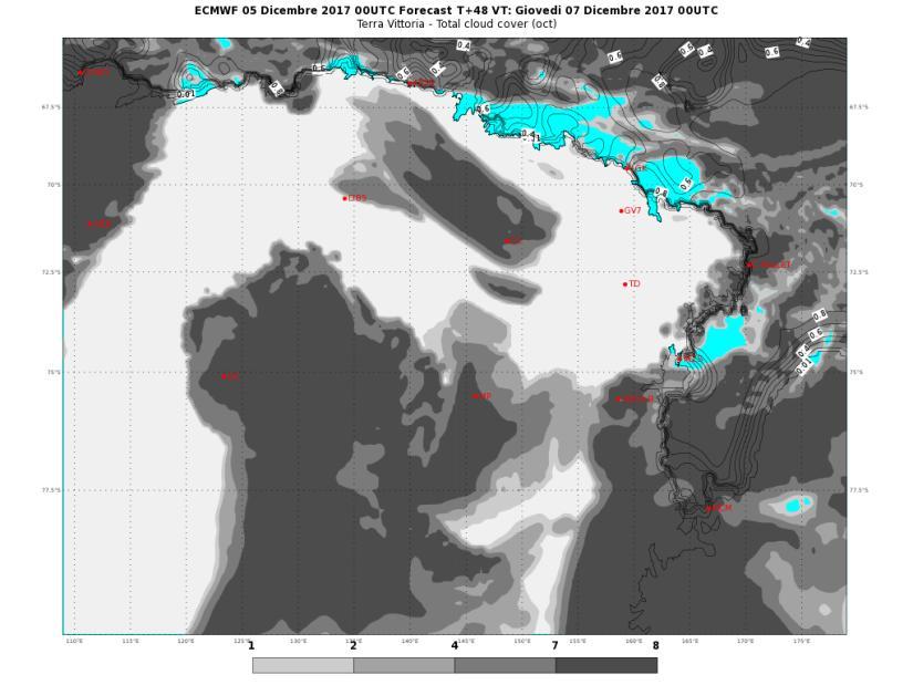
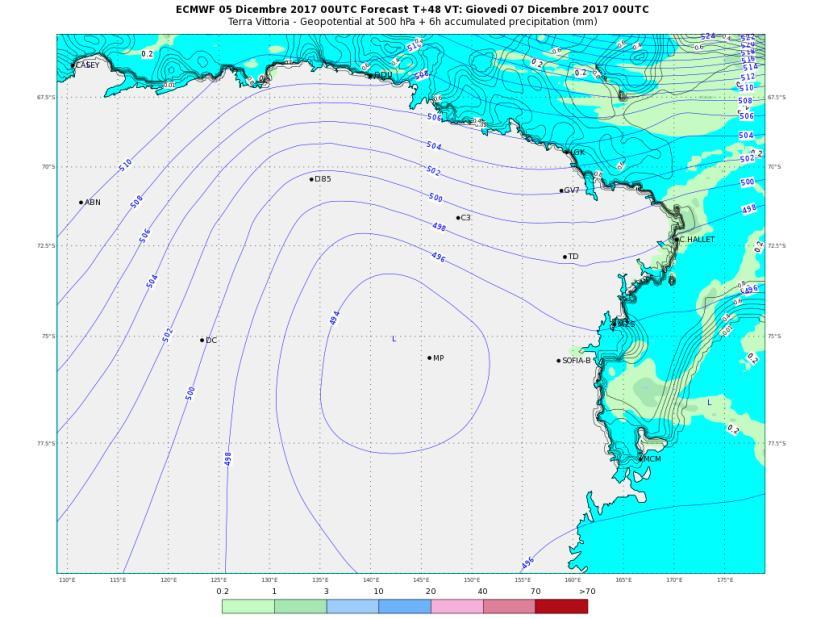
5 PREVISIONI - FORECASTS OGGI ORE 07 LT TODAY 07 LT

6 PREVISIONI - FORECASTS OGGI ORE 13 LT TODAY 13 LT


7 PREVISIONI - FORECASTS OGGI ORE 19 LT TODAY 19 LT
8 WEATHER FORECAST FOR TODAY AT TERRA NOVA BAY Thursday 07/12/2017 ORE 07 ORE 13 ORE 19 CIELO FENOMENI NIL NIL NIL VENTO MZS SW 10/15 KT WSW 10/15 KT WSW 10/15 KT VENTO BOULDER SW 15/20 KT WSW 15/20 KT WSW 15/20 KT TEMPERATURA [ C] -08/-06 C -07/-05 C -06/-04 C WIND CHILL [ C] -22/-19 C -20/-17 C -18/-15 C AVVISI NIL NIL NIL


9 PREVISIONI - FORECASTS DOMANI ORE 01 LT TOMORROW 01 LT


10 PREVISIONI - FORECASTS DOMANI ORE 07 LT TOMORROW 07 LT

11 PREVISIONI - FORECASTS DOMANI ORE 13 LT TOMORROW 13 LT


12 PREVISIONI - FORECASTS DOMANI ORE 19 LT TOMORROW 19 LT
13 WEATHER FORECAST FOR TOMORROW AT TERRA NOVA BAY Friday 08/12/2017 ORE 07 ORE 13 ORE 19 CIELO FENOMENI NIL POSSIBILE NEVE DEBOLE NIL VENTO MZS WSW 10/15 KT WNW 10 KT WNW 10 KT VENTO BOULDER WSW 15/20 KT WNW 15/20 KT WSW 15/20 KT TEMPERATURA [ C] -07/-05 C -06/-04 C -06/-04 C WIND CHILL [ C] -20/-17 C -17/-14 C -17/-14 C AVVISI NIL NIL NIL
14 WEATHER TENDENCY AT TERRA NOVA BAY Saturday 09/12/2017 MATTINO POMERIGGIO CIELO FENOMENI NIL POSSIBILE NEVISCHIO VENTO MZS WSW 05/10 KT SW 05/10 KT VENTO BOULDER WSW 10/15 KT WSW 10/15 KT TEMPERATURA [ C] -07/-05 C -06/-04 C WIND CHILL [ C] -14/-12 C -13/-11 C AVVISI NIL NIL
 MAX temperature (ore 14:16/L) -3.")
 80 % MIN humidity (ore 05:16/L) 47 % MAX")

15 Extreme Values of Yesterday 06/12/2017 UTC time (13:00 05/12 13:00 06/12) MAX temperature (ore 14:16/L) -3.1 C MIN temperature (ore 00:34/L) -5.5 C MAX humidity (ore 21:29/L) 80 % MIN humidity (ore 05:16/L) 47 % MAX wind direction/speed (ore 06:47/L) 230/19 KT Remark: the reported values are referred to the previous day in terms of Universal Time and not in local time (UTC+13).
16 Temperature measured during the XXXIII Expedition ENEIDE weather station (MZS) - Anctartic Climatology Observatory 4,0 2,0 0,0-2,0-4,0-6,0-8,0-10,0-12,0-14,0-16,0-18,0-20,0-22,0-24,0-26,0-28,0 T max T min T media max decadale
![MAX wind [kt] measured during the](/docs-images/74/69988113/images/17-0.jpg "XXXIII Expedition ENEIDE weather")

17 MAX wind [kt] measured during the XXXIII Expedition ENEIDE weather station (MZS) - Anctartic Climatology Observatory 70,0 60,0 50,0 40,0 30,0 20,0 10,0 0,0
18 Per ulteriori informazioni contattare l Ufficio Meteorologico di MZS int. 510 For further information please contact MZS Met Office ext. 510 AVVERTENZA/WARNING Le presenti informazioni NON sono destinate alla pianificazione di volo e/o pre-volo The informations here presented are NOT intended for flight planning and/or pre-flight
IAMCO-YOPP. Italian Antarctic Meteo-Climatological Observatory at MZS, Victoria Land and at Concordia.
 IAMCO-YOPP Italian Antarctic Meteo-Climatological Observatory at MZS, Victoria Land and at Concordia http://www.climantartide.it Principal investigator Paolo Grigioni paolo.grigioni@enea.it ENEA Areas
LOCAL CLIMATOLOGICAL DATA Monthly Summary July 2013
 Deg. Days Precip Ty Precip Wind Solar Hu- Adj. to Sea Level mid- ity Avg Res Res Peak Minute 1 fog 2 hvy fog 3 thunder 4 ice plt 5 hail 6 glaze 7 duststm 8 smk, hz 9 blw snw 1 2 3 4A 4B 5 6 7 8 9 12 14
OPERATIONAL METEOROLOGY AND THE METEO-CLIMATOLOGICAL ANTARCTIC OBSERVATORY
 OPERATIONAL METEOROLOGY AND THE METEO-CLIMATOLOGICAL ANTARCTIC OBSERVATORY AN OVERVIEW AND PLANS FOR XXIX ITALIAN EXPEDITION IN ANTARCTICA Dolci S., Grigioni P., De Silvestri L., Scarchilli C., Schioppo
WEATHER FORECAST DHAKA
 WEATHER FORECAST DHAKA 02.01.2019 Hourly 2 PM 4 PM 8 PM 11 PM Temp. / Dew Point 26 / 12 25 / 12 20 / 12 18 / 13 Wind 15 km/h WNW 13 km/h WNW 4 km/h WNW 6 km/h WNW Humidity 41% 43% 62% 71% Chance of Precip
CropCast Corn and Soybean Report Kenny Miller Friday, March 17, 2017
 Accumulated Rainfall (inches) Accumulated GDDs Temperature ( F)/Wind Speed (mph) Precipitation (inches) CropCast Corn and Soybean Report Kenny Miller Friday, March 17, 2017 Peoria, IL Regional Forecast
Tropical Update. 5 PM EDT Thursday, August 27, 2015 Tropical Storm Erika
 Tropical Update 5 PM EDT Thursday, August 27, 2015 Tropical Storm Erika This update is intended for government and emergency response officials, and is provided for informational and situational awareness
Forecast for 6/28-7/31. Forecaster: Matthew Brewer Forecast made at: 12z 6/27/2017
 Forecast for 6/28-7/31 Forecaster: Matthew Brewer Forecast made at: 12z 6/27/2017 Whiteface lodge Mesonet Meteogram for the past 24 hours http://www.nysmesonet.org/data/meteogram#?stid=wfmb Whiteface Summit
Tropical Update. 1 PM EDT Monday, May 21, 2018 Caribbean Disturbance (20%)
") Tropical Update 1 PM EDT Monday, May 21, 2018 Caribbean Disturbance (20%) This update is intended for government and emergency response officials, and is provided for informational and situational awareness
Tropical Update 1 PM EDT Monday, May 21, 2018 Caribbean Disturbance (20%) This update is intended for government and emergency response officials, and is provided for informational and situational awareness
Aeronautical Information Service
 , St. Maarten and The Netherlands EFFECTIVE DATE: 31 MARCH 2016 KNMI Meteorological Services Information for TNCB, TNCE and TNCS Page: GEN 2.7-1 Sunrise / sunset tables 1. The tables on the following pages
Introduction to Meteorology and Weather Forecasting
 Introduction to Meteorology and Weather Forecasting ENVI1400 : Meteorology and Forecasting : lecture 1 2 040909 ENVI1400 : Meteorology and Forecasting : lecture 1 3 040914 ENVI1400 : Meteorology and Forecasting
LOCAL CLIMATOLOGICAL DATA Monthly Summary November 2006
 Deg. Days Precip Ty Precip Wind Sun Hu- Adj. to Sea Level mid- ity Avg Res Res Peak Minute 1 fog 2 hvy fog 3 thunder 4 ice plt 5 hail 6 glaze 7 duststm 8 smk, hz 9 blw snw 1 2 3 4A 4B 5 6 7 8 9 12 14 15
APPENDICE I. GO message. .. (date) FROM: Expedition Leader Mario Zucchelli Station
 FROM: Expedition Leader Mario Zucchelli Station") Appendice I-1 APPENDICE I Sono riportati in questa Appendice: esempio di messaggio GO-NO GO; esempio di previsione per il C130/L100; esempio di documentazione di volo ( folder ) per il C130/L100; punti
Appendice I-1 APPENDICE I Sono riportati in questa Appendice: esempio di messaggio GO-NO GO; esempio di previsione per il C130/L100; esempio di documentazione di volo ( folder ) per il C130/L100; punti
MARINE WEATHER HINDCAST REPORT
 MARINE WEATHER HINDCAST REPORT PREPARED FOR US SAILING INVESTIGATIVE PANEL VESSEL : Aegean INCIDENT LOCATION : APPROX 32.45N 117.30W INCIDENT TIME : APPROX 1:30AM Apr. 28 2012 PREPARED BY SAM WILSON M.S.
Deliverable 4-2: Assessment items. Activity-oriented Quiz for Weather or Not? Investigation in Exploring the Environment
 Deliverable 4-2: Assessment items Activity-oriented Quiz for Weather or Not? Investigation in Exploring the Environment In Weather or Not? you predicted the weather using satellite images and other kinds
LOCAL CLIMATOLOGICAL DATA Monthly Summary September 2016
 Deg. Days Precip Ty Precip Wind Solar Hu- Adj. to Sea Level mid- ity Avg Res Res Peak 2 Minute 1 fog 2 hvy fog 3 thunder 4 ice plt 5 hail 6 glaze 7 duststm 8 smk, hz 9 blw snw 1 2 3 4A 4B 5 6 7 8 9 11
WEDNESDAY 30 TH AUGUST, :57 p.m. Tropical Storm Irma forms in the Atlantic. Don t let your guard down, always #Be Ready.
 Chapter 1 - The Set Up In the days leading up to Irma a series of composed and sobering text messages, presented in truncated form below, from Department of Disaster Management warned us of the pending
Remote Sensing Observations AOSC 200 Tim Canty
 Remote Sensing Observations AOSC 200 Tim Canty Class Web Site: http://www.atmos.umd.edu/~tcanty/aosc200 Topics for today: Maps Radar Satellite Observations Lecture 04 Feb 7 2019 1 Today s Weather Map http://www.wpc.ncep.noaa.gov/sfc/namussfcwbg.gif
Tropical Update. 11 AM EDT Tuesday, October 9, 2018 Hurricane Michael, Tropical Storm Leslie, Tropical Storm Nadine
 Tropical Update 11 AM EDT Tuesday, October 9, 2018 Hurricane Michael, Tropical Storm Leslie, Tropical Storm Nadine This update is intended for government and emergency response officials, and is provided
Introduction to Climatology. GEOG/ENST 2331: Lecture 1
 Introduction to Climatology GEOG/ENST 2331: Lecture 1 Us! Graham Saunders (RC 2006C) graham.saundersl@lakeheadu.ca! Jason Freeburn (RC 2004) jtfreebu@lakeheadu.ca Graham Saunders! Australian Weather Bureau!
Tropical Update. 5 PM EDT Tuesday, September 5, 2017 Hurricane Irma, Tropical Storm Jose, and Tropical Depression Thirteen
 Tropical Update 5 PM EDT Tuesday, September 5, 2017 Hurricane Irma, Tropical Storm Jose, and Tropical Depression Thirteen This update is intended for government and emergency response officials, and is
Tropical Update 11 AM EDT Thursday, September 6, 2018 Tropical Depression Gordon, Hurricane Florence, Invest 92L (90%) & African Tropical Wave (50%)
 & African Tropical Wave (50%)") Tropical Update 11 AM EDT Thursday, September 6, 2018 Tropical Depression Gordon, Hurricane Florence, Invest 92L (90%) & African Tropical Wave (50%) This update is intended for government and emergency
Tropical Update 11 AM EDT Thursday, September 6, 2018 Tropical Depression Gordon, Hurricane Florence, Invest 92L (90%) & African Tropical Wave (50%) This update is intended for government and emergency
IWT Scenario 2 Integrated Warning Team Workshop National Weather Service Albany, NY October 31, 2014
 IWT Scenario 2 Integrated Warning Team Workshop National Weather Service Albany, NY October 31, 2014 09 10 11 12 13 Scenario 2 Timeline December 9-13 Tue Wed Thu Fri Sat Tue, Dec. 9 @ 5 am 2014 2014 2014
CropCast Corn and Soybean Report Kyle Tapley Monday, March 20, 2017
 Accumulated Rainfall (inches) Accumulated GDDs Temperature ( F)/Wind Speed (mph) Precipitation (inches) CropCast Corn and Soybean Report Kyle Tapley Monday, March 20, 2017 Peoria, IL Regional Forecast
Fun with Weather Maps! (no, really stop laughing) AOSC 200 Tim Canty
 AOSC 200 Tim Canty") Fun with Weather Maps! (no, really stop laughing) AOSC 200 Tim Canty Class Web Site: http://www.atmos.umd.edu/~tcanty/aosc200 Topics for today: Observations Station Model Temperature Maps Pressure Maps
Fun with Weather Maps! (no, really stop laughing) AOSC 200 Tim Canty Class Web Site: http://www.atmos.umd.edu/~tcanty/aosc200 Topics for today: Observations Station Model Temperature Maps Pressure Maps
WEATHER FORECAST DHAKA
 WEATHER FORECAST DHAKA 05.09.2018 Hourly 2 PM 4 PM 8 PM 11 PM Temp. / Dew Point 33 / 25 32 / 25 29 / 24 28 / 25 Wind 18 km/h ESE 16 km/h SE 15 km/h SE 15 km/h ESE Humidity 64% 67% 78% 81% Chance of Precip
Implementation Guidance of Aeronautical Meteorological Observer Competency Standards
 Implementation Guidance of Aeronautical Meteorological Observer Competency Standards The following guidance is supplementary to the AMP competency Standards endorsed by Cg-16 in Geneva in May 2011. Please
Maps and Remote Sensing AOSC 200 Tim Canty
 Maps and Remote Sensing AOSC 200 Tim Canty Class Web Site: http://www.atmos.umd.edu/~tcanty/aosc200 Topics for today: Weather Maps Radar Satellite Observations Lecture 04 Feb 7 2019 1 Today s Weather Map
U.S. WIND, SCS, FLOOD, WINTER WEATHER
 U.S. WIND, SCS, FLOOD, WINTER WEATHER An unusually strong winter storm crossing the Central Plains continues to bring winter weather, strong winds, heavy precipitation and severe thunderstorms to areas
Cómo contar la predicción probabilistica? Part II: From body language to percentages
 Cómo contar la predicción probabilistica? How to tell probabilities in weather forecasting? Part II: From body language to percentages 1 From 100% qualitative to 100% quantitative probability communication
Deutscher Wetterdienst
 WakeNet3-Greenwake Workshop Wake Vortex & Wind Monitoring Sensors in all weather conditions DWD s new Remote Wind Sensing Equipment for an Integrated Terminal Weather System (ITWS) Frank Lehrnickel Project
Finnish Open Data Portal for Meteorological Data
 18.11.2013 1 Finnish Open Data Portal for Meteorological Data 14th Workshop on meteorological operational systems Roope Tervo Finnish Meteorological Institute Example of Data Sets -- Observations Data
Technical Report DMI SYNOP AWS Summit. Data status March Ellen Vaarby Laursen. SYNOP weather station Summit.
 10-09 DMI SYNOP AWS 04416 Summit. Data status March 2010. Ellen Vaarby Laursen SYNOP weather station 04416 Summit Picture Taken: 2007:06:20 16:16:11 Picture Taken: 2009:07:09 08:22:51 Copenhagen 2010 www.dmi.dk/dmi/tr
Module 11: Meteorology Topic 5 Content: Weather Maps Notes
 Introduction A variety of weather maps are produced by the National Weather Service and National Oceanographic Atmospheric Administration. These maps are used to help meteorologists accurately predict
Hurricane Harvey: SE Texas Impacts. 10 AM CDT UPDATE Saturday, August 26, 2017 Prepared by: Dan Reilly, Brian Kyle
 Hurricane Harvey: SE Texas Impacts 10 AM CDT UPDATE Saturday, August 26, 2017 Prepared by: Dan Reilly, Brian Kyle Latest Observations and Radar Hurricane Harvey centered near Victoria and weakening Wind
Application and verification of ECMWF products 2012
 Application and verification of ECMWF products 2012 National Meteorological Administration 1. Summary of major highlights The objective verification of all deterministic models forecasts in use have been
By: J Malherbe, R Kuschke
 2015-10-27 By: J Malherbe, R Kuschke Contents Summary...2 Overview of expected conditions over South Africa during the next few days...3 Significant weather events (27 October 2 November)...3 Conditions
Accessing and Using National Long Term Ecological Research (LTER) Climate and Hydrology Data from ClimDB and HydroDB: A Tutorial
 Climate and Hydrology Data from ClimDB and HydroDB: A Tutorial") Accessing and Using National Long Term Ecological Research (LTER) Climate and Hydrology Data from ClimDB and HydroDB: A Tutorial Gordon M. Heisler USDA Forest Service, Syracuse, NY Gary Fisher U.S. Geological
Accessing and Using National Long Term Ecological Research (LTER) Climate and Hydrology Data from ClimDB and HydroDB: A Tutorial Gordon M. Heisler USDA Forest Service, Syracuse, NY Gary Fisher U.S. Geological
METEOSAT PRODUCTS FOR SURVEILLANCE: THE EUSKALMET CASE.
 METEOSAT PRODUCTS FOR SURVEILLANCE: THE EUSKALMET CASE. S. Gaztelumendi (1)(2), K. Otxoa de Alda (1)(2), R. Hernandez (1)(2), J. Egaña (1)(2), I. R. Gelpi (1)(2). (1) Basque Meteorology Agency (EUSKALMET).
Winter Storm Saturday into Sunday December 14-15, 2013
 Winter Storm Saturday into Sunday December 14-15, 2013 Prepared 900 AM EST Friday December 13, 2013 Al Cope NOAA s NJ Forecast office http://www.erh.noaa.gov/phi/ Purpose of Briefing Briefing #3 for event.
Tropical Update. 5 PM EDT Sunday, October 7, 2018 Tropical Storm Michael, Tropical Storm Leslie, & Invest 92L (30%)
") Tropical Update 5 PM EDT Sunday, October 7, 2018 Tropical Storm Michael, Tropical Storm Leslie, & Invest 92L (30%) This update is intended for government and emergency response officials, and is provided
Tropical Update 5 PM EDT Sunday, October 7, 2018 Tropical Storm Michael, Tropical Storm Leslie, & Invest 92L (30%) This update is intended for government and emergency response officials, and is provided
South African Weather Service. Description of Public Weather and Warning Services. Tshepho Ngobeni. 18 November 2013
 South African Weather Service Description of Public Weather and Warning Services Tshepho Ngobeni 18 November 2013 SAWS-SWFDP_PRES_18-22_Nov_2013 1 Outline Forecasting Descriptions and Processes Severe
Effective: SPECI ALERTING
 AUSTRALIA AERONAUTICAL INFORMATION SERVICE AIRSERVICES AUSTRALIA GPO BOX 367, CANBERRA ACT 2601 Phone: 02 6268 4874 Email: aim.editorial@airservicesaustralia.com Effective: AERONAUTICAL INFORMATION CIRCULAR
Tropical Update. 11 AM EDT Wednesday, October 10, 2018 Hurricane Michael, Hurricane Leslie & Tropical Storm Nadine, Caribbean Low (40%)
") Tropical Update 11 AM EDT Wednesday, October 10, 2018 Hurricane Michael, Hurricane Leslie & Tropical Storm Nadine, Caribbean Low (40%) This update is intended for government and emergency response officials,
Tropical Update 11 AM EDT Wednesday, October 10, 2018 Hurricane Michael, Hurricane Leslie & Tropical Storm Nadine, Caribbean Low (40%) This update is intended for government and emergency response officials,
Current Details from the Joint Typhoon Warning Center
 Current Details from the Joint Warning Center COORDINATES: 10.2 north, 148.1 east (previous location: 10.1 north, 148.3 east) LOCATION: 520 kilometers (325 miles) southeast of Andersen Air Force Base,
Tropical Update. 5 AM EDT Wednesday, September 6, 2017 Hurricane Irma, Tropical Storm Jose, and Tropical Storm Katia
 Tropical Update 5 AM EDT Wednesday, September 6, 2017 Hurricane Irma, Tropical Storm Jose, and Tropical Storm Katia This update is intended for government and emergency response officials, and is provided
MxVision WeatherSentry Web Services Content Guide
 MxVision WeatherSentry Web Services Content Guide July 2014 DTN 11400 Rupp Drive Minneapolis, MN 55337 00.1.952.890.0609 This document and the software it describes are copyrighted with all rights reserved.
SOFTWARE USER MANUAL. Weather Capture Advance WS1640 WM9280
 SOFTWARE USER MANUAL Weather Capture Advance WS1640 WM9280 1 TABLE OF CONTENTS 1. Introduction 3 1.1 System requirements 1.2 Connection of the weather station 1.3 Installation of the Weather Capture Advance
Model Output Statistics (MOS)
") Model Output Statistics (MOS) Numerical Weather Prediction (NWP) models calculate the future state of the atmosphere at certain points of time (forecasts). The calculation of these forecasts is based on
Model Output Statistics (MOS) Numerical Weather Prediction (NWP) models calculate the future state of the atmosphere at certain points of time (forecasts). The calculation of these forecasts is based on
Weather briefing Strong Coastal Nor easter November 7 th -8 th, 2012
 Weather briefing Strong Coastal Nor easter November 7 th -8 th, 2012 Prepared 1215 PM EDT Wednesday November 7, 2012 Gary Szatkowski NOAA s NJ Forecast Office http://www.erh.noaa.gov/phi/ Purpose of Briefing
SAWS: Met-Ocean Data & Infrastructure in Support of Industry, Research & Public Good. South Africa-Norway Science Week, 2016
 SAWS: Met-Ocean Data & Infrastructure in Support of Industry, Research & Public Good South Africa-Norway Science Week, 2016 Marc de Vos, November 2016 South Africa: Context http://learn.mindset.co.za/sites/default/files/resourcelib/e
NWS SERFC Hydrologic Vulnerability Assessment. Monday, March 9 th, 2015 NOAA, National Weather Service Southeast River Forecast Center
 NWS SERFC Hydrologic Vulnerability Assessment Monday, March 9 th, 2015 NOAA, National Weather Service Southeast River Forecast Center Current Weather Map Today s weather map shows a blossoming system in
Application and verification of ECMWF products 2009
 Application and verification of ECMWF products 2009 Hungarian Meteorological Service 1. Summary of major highlights The objective verification of ECMWF forecasts have been continued on all the time ranges
NOAA s National Weather Service Philadelphia/Mt. Holly NJ
 Early Week Coastal Flooding and snow Hazards and Impacts: Coastal Flooding: With the persistent onshore flow, and a new moon today, coastal flooding is expected at high tide through Tuesday morning. Moderate
The Future of the USAP Antarctic Internet Data Distribution System
 The Future of the USAP Antarctic Internet Data Distribution System A discussion on LDM Efforts at ASC with Satellite Ground Stations update Andrew B. Archer Antarctic Support Contract Matthew A. Lazzara
Tropical Update. 5 AM EDT Monday, October 8, 2018 Tropical Storm Michael, Tropical Storm Leslie, Invest 92L (10%) & African Tropical Wave (50%)
 & African Tropical Wave (50%)") Tropical Update 5 AM EDT Monday, October 8, 2018 Tropical Storm Michael, Tropical Storm Leslie, Invest 92L (10%) & African Tropical Wave (50%) This update is intended for government and emergency response
Tropical Update 5 AM EDT Monday, October 8, 2018 Tropical Storm Michael, Tropical Storm Leslie, Invest 92L (10%) & African Tropical Wave (50%) This update is intended for government and emergency response
Operational Applications of Awos Network in Turkey
 Operational Applications of Awos Network in Turkey by Soner Karatas Turkish State Meteorological Service Electronic Observing Systems Division Kütükcü Alibey Cad. No:4 06120 Kalaba-Ankara-TURKEY Tel:+90-312-302
The Climate of Bryan County
 The Climate of Bryan County Bryan County is part of the Crosstimbers throughout most of the county. The extreme eastern portions of Bryan County are part of the Cypress Swamp and Forest. Average annual
Weather briefing Strong Coastal Nor easter November 7 th -8 th, 2012
 Weather briefing Strong Coastal Nor easter November 7 th -8 th, 2012 Prepared 1245 PM EDT Tuesday November 6, 2012 Gary Szatkowski NOAA s NJ Forecast Office Weather.gov/phi Purpose of Briefing Briefing
Messages of the Day December 2013
 Messages of the Day December 2013 Thursday, December 5, 2013 Measuring Freezing Rain + Snow Training Shorts Freezing rain will most likely make an appearance in some parts of the country this month. How
NOAA s National Weather Service Philadelphia/Mt. Holly NJ
 Snow and Coastal Flooding through this evening Hazards and Impacts: Coastal Flooding: With the persistent onshore flow, and a new moon yesterday, coastal flooding is expected at high tide today. Moderate
U.S. WIND, SCS, FLOOD, WINTER WEATHER
 U.S. WIND, SCS, FLOOD, WINTER WEATHER The threat continues for strong winds, heavy snow, heavy rain and severe thunderstorms according to the U.S. National Weather Service (NWS). The threat comes with
Checklist Templates for Direct Observation and Oral Assessments (AMOB)
") Checklist Templates for Direct Observation and Oral Assessments (AMOB) Competency Assessment System Hong Kong Observatory Hong Kong, China Prepared By: Signed Approved By: Signed Date: 20/08/2012 Date:
Checklist Templates for Direct Observation and Oral Assessments (AMOB) Competency Assessment System Hong Kong Observatory Hong Kong, China Prepared By: Signed Approved By: Signed Date: 20/08/2012 Date:
Infrastructure and Expertise available to the Advisory Section
 Infrastructure and Expertise available to the Advisory Section By Lucky Nhlanhla Sigudla Advisory Section Outline INTRODUCTION STRUCTURE PRESENT INFRATUCTURE EXPERTISE SPECIFIC ISSUES USER ACTIVITIES CONCLUSION
Significant Flooding Expected
 Significant Flooding Expected Decision Support Briefing #5 As of: 9:00 AM September 14, 2018 What Has Changed? Flash Flood Watch now in effect for part of area, will be expanded later today 9/14/2018 9:23
Major Winter Storm to impact Western Washington. 17 January 2012 National Weather Service Seattle/Tacoma
 Major Winter Storm to impact Western Washington 17 January 2012 National Weather Service Seattle/Tacoma Current Warnings Winter Storm Warning for all of Western Washington, except: Northwest interior Extreme
May 2017 Weather Summary P a g e 1 Alexander, P.J. & Power, S.
 May 2017 Weather Summary P a g e 1 May 2017 Beaufort Weather Station Summary Logistics May was the first full month of operation of the MaREI weather observing system (WOS) located on the grounds of the
Major Hurricane Matthew Briefing Situation Overview
 Major Hurricane Matthew Briefing Situation Overview At 5 p.m. Tuesday, Category 4 Hurricane Matthew was about 860 miles South-Southeast of Mayport, Florida, moving north around 10 mph. Maximum sustained
Safety Matters C ENTENNIAL SCHOOL DISTRICT
 C ENTENNIAL SCHOOL DISTRICT Volume 3, Number 7 Safety Matters Safety Matters is the monthly awareness letter of the Centennial School District certified Joint Labor/ Management Workplace Safety Committee.
GC Briefing. Weather Sentinel Tropical Storm Michael. Status at 8 AM EDT (12 UTC) Today (NHC) Discussion. October 11, 2018
 Today (NHC) Discussion. October 11, 2018") GC Briefing Weather Sentinel Tropical Storm Michael October 11, 2018 After making landfall as a high-end category-4 hurricane on the Florida Panhandle, Michael weakened to tropical storm status early this
GC Briefing Weather Sentinel Tropical Storm Michael October 11, 2018 After making landfall as a high-end category-4 hurricane on the Florida Panhandle, Michael weakened to tropical storm status early this
Forecasting of Optical Turbulence in Support of Realtime Optical Imaging and Communication Systems
 Forecasting of Optical Turbulence in Support of Realtime Optical Imaging and Communication Systems Randall J. Alliss and Billy Felton Northrop Grumman Corporation, 15010 Conference Center Drive, Chantilly,
Application and verification of ECMWF products 2018
 Application and verification of ECMWF products 2018 National Meteorological Administration, Romania 1. Summary of major highlights In the field of numerical model verification, the daily GRID_STAT method
Northavimet. User Guide. New LLF
 Northavimet User Guide New LLF 1 Table of Contents New LLF - Denmark and Sweden... 3 Low Level Forecast - "LLF"... 4 LLF Denmark/Sweden... 4 Purpose... 4 Areas... 4 Naming example... 6 Forecast parameters...
Assimilation of Himawari-8 Atmospheric Motion Vectors into the Numerical Weather Prediction Systems of Japan Meteorological Agency
 Assimilation of Himawari-8 Atmospheric Motion Vectors into the Numerical Weather Prediction Systems of Japan Meteorological Agency Koji Yamashita Japan Meteorological Agency kobo.yamashita@met.kishou.go.jp,
Introduction to Climatology. GEOG/ENST 2331: Lecture 1
 Introduction to Climatology GEOG/ENST 2331: Lecture 1 Us Graham Saunders graham.saunders@lakeheadu.ca Jason Freeburn (RC 2004) jtfreebu@lakeheadu.ca Graham Saunders Australian Weather Bureau Environment
Tropical Update. 5 PM EDT Thursday, September 7, 2017 Hurricane Irma, Hurricane Jose, and Hurricane Katia
 Tropical Update 5 PM EDT Thursday, September 7, 2017 Hurricane Irma, Hurricane Jose, and Hurricane Katia This update is intended for government and emergency response officials, and is provided for informational
CropCast Corn and Soybean Report Kenny Miller Tuesday, March 14, 2017
 Accumulated Rainfall (inches) Accumulated GDDs Temperature ( F)/Wind Speed (mph) Precipitation (inches) CropCast Corn and Soybean Report Kenny Miller Tuesday, March 14, 2017 Peoria, IL Regional Forecast
Temperature, Observations, and Maps AOSC 200 Tim Canty. Weather and Climate
 Temperature, Observations, and Maps AOSC 200 Tim Canty Class Web Site: http://www.atmos.umd.edu/~tcanty/aosc200 Topics for today: Climate Weather Observations Weather Maps Lecture 03 Feb 5 2019 1 Weather
Development and Validation of Polar WRF
 Polar Meteorology Group, Byrd Polar Research Center, The Ohio State University, Columbus, Ohio Development and Validation of Polar WRF David H. Bromwich 1,2, Keith M. Hines 1, and Le-Sheng Bai 1 1 Polar
Tokyo Climate Center s activities as RCC Tokyo
 First WMO Workshop on Operational Climate Prediction Pune, India, 09-11 November 2015 Tokyo Climate Center s activities as RCC Tokyo Arata Endo Tokyo Climate Center Japan Meteorological Agency E-mail:
Trends Forecasting. Overview: Objectives: GLEs Addressed: Materials: Activity Procedure:
 Trends Forecasting Overview: How do meteorologists forecast weather? Students learn one of 5 main methods for forecasting weather, use it to create a forecast, and analyze results. Objectives: The student
SAMPLE. SITE SPECIFIC WEATHER ANALYSIS Wind Report. Robinson, Smith & Walsh. John Smith. July 1, 2017 REFERENCE: 1 Maple Street, Houston, TX 77034
 SAMPLE SITE SPECIFIC WEATHER ANALYSIS Wind Report PREPARED FOR: Robinson, Smith & Walsh John Smith July 1, 2017 REFERENCE: JACK HIGGINS / 4151559-01 1 Maple Street, Houston, TX 77034 CompuWeather Sample
WEATHER FORECAST DHAKA
 WEATHER FORECAST DHAKA 21.10.2017 Hourly 1 PM 4 PM 8 PM 11 PM Temp. / Dew Point 26 / 24 26 / 23 26 / 22 26 / 22 Wind 20 km/h S 29 km/h SSW 17 km/h SW 13 km/h WSW Humidity 91% 86% 79% 78% Chance of Precip
A WRF-based rapid updating cycling forecast system of. BMB and its performance during the summer and Olympic. Games 2008
 A WRF-based rapid updating cycling forecast system of BMB and its performance during the summer and Olympic Games 2008 Min Chen 1, Shui-yong Fan 1, Jiqin Zhong 1, Xiang-yu Huang 2, Yong-Run Guo 2, Wei
AN EMPIRICAL MODEL FOR AERODROME WIND FORECASTING DURING THE PASSAGE OF TROPICAL CYCLONES
 P1.1 AN EMPIRICAL MODEL FOR AERODROME WIND FORECASTING DURING THE PASSAGE OF TROPICAL CYCLONES T. C. Cheung The Chinese University of Hong Kong Hong Kong China P. Cheung C. C. Lam * Hong Kong Observatory
Observation requirements for regional reanalysis
 Observation requirements for regional reanalysis Richard Renshaw 30 June 2015 Why produce a regional reanalysis? Evidence from operational NWP 25km Global vs 12km NAE ...the benefits of resolution global
Wali Ullah Khan Pakistan Meteorological Department
 An overview of Weather Observation practices over Pakistan By Wali Ullah Khan Pakistan Meteorological Department JMA/WMO TRAINING WORKSHOP ON CALIBRATION AND MAINTENANCE OF METEOROLOGICAL INSTRUMENTS IN
Weather Information for Europe 3 May 2018
 Weather Information for Europe 3 May 2018 Weatherproofing the network A collaborative approach Jaakko Nuottokari EUMETNET WG AVIMET Chair Head of Aviation and Defence Finnish Meteorological Institute Jaakko.Nuottokari@fmi.fi
Tropical Update. 5 AM EDT Thursday, September 7, 2017 Hurricane Irma, Hurricane Jose, and Hurricane Katia
 Tropical Update 5 AM EDT Thursday, September 7, 2017 Hurricane Irma, Hurricane Jose, and Hurricane Katia This update is intended for government and emergency response officials, and is provided for informational
Discoverer Automated Weather System Data Quality Control Report
 Discoverer Automated Weather System Data Quality Control Report Kennard B. Kasper and Shawn R. Smith World Ocean Circulation Experiment (WOCE) Surface Meteorological Data Assembly Center Center for Ocean
Government of Sultanate of Oman Public Authority of Civil Aviation Directorate General of Meteorology. National Report To
 Government of Sultanate of Oman Public Authority of Civil Aviation Directorate General of Meteorology National Report To Panel on Tropical Cyclones in the Bay of Bengal And Arabian Sea 43rd Session, India
Weather forecasts column in European newspapers
 Weather forecasts column in European newspapers Panos Giannopoulos (1), Christoph. Siegrist (2) (1) Hellenic National Meteorological Service, (2) SF Meteo 11th EMS / 10th ECAM Berlin 2011 2011 150 years
Tropical Update. 5 PM EDT Sunday, September 10, 2017 Hurricane Irma, Hurricane Jose, Tropical Wave (60%)
") Tropical Update 5 PM EDT Sunday, September 10, 2017 Hurricane Irma, Hurricane Jose, Tropical Wave (60%) This update is intended for government and emergency response officials, and is provided for informational
Tropical Update 5 PM EDT Sunday, September 10, 2017 Hurricane Irma, Hurricane Jose, Tropical Wave (60%) This update is intended for government and emergency response officials, and is provided for informational
Atlantic Basin Satellite Image
 Tropical Update 11 AM EDT Friday, September 7, 2018 Tropical Depression Gordon, Tropical Storm Florence, Potential Tropical Cyclone #8 (90%), Invest 92L (90%) This update is intended for government and
Custom Weather Forecast
 1 of 23 Custom Weather Forecast 2018 Chicago Yacht Club s Race To Mackinac- Cruising Division Disclaimer: The user assumes all risk related to the use of this Custom Weather Forecast. The crew of the participating
Tropical Update 6 AM EDT Friday, October 7, 2016 Hurricane Matthew & Hurricane Nicole
 Tropical Update 6 AM EDT Friday, October 7, 2016 Hurricane Matthew & Hurricane Nicole This update is intended for government and emergency response officials, and is provided for informational and situational
A Complex Weather System: Tuesday Afternoon into Thursday March 3 5, 2015
 A Complex Weather System: Tuesday Afternoon into Thursday March 3 5, 2015 Briefing #1, prepared 900 AM EST Tuesday, March 3, 2015 by Meteorologists at NWS - WFO Mount Holly, NJ To promote situational awareness
GEN 3.5 METEOROLOGICAL SERVICES
 AIP GEN 3.5-1 GEN 3.5 METEOROLOGICAL SERVICES 1. RESPONSIBLE SERVICE The meteorological services for civil aviation at Jordan are provided by the Jordanian Meteorological Department. Postal Address: Director
WEATHER FORECAST DHAKA
 WEATHER FORECAST DHAKA 02.07.2018 Hourly 2 PM 4 PM 8 PM 11 PM Temp. / Dew Point 32 / 26 31 / 26 28 / 25 28 / 25 Wind 13 km/h S 12 km/h S 15 km/h S 12 km/h S Humidity 74% 77% 83% 84% Chance of Precip 73%
Forecasting the "Beast from the East" and Storm Emma
 Forecasting the "Beast from the East" and Storm Emma Ken Mylne and Rob Neal with contributions from several scientists across the Met Office ECMWF UEF Meeting, 5-8 June 2018 Beast started 24 Feb Emma reached
NOAA s National Weather Service Philadelphia/Mt. Holly NJ
 Next Briefing Package: Friday, October 2, 2015 no later than 300 PM Hazards and Impacts: Overview: A dangerous weather pattern still threatens our region. Threats include very heavy rainfall, inland river