Synoptic Environments Associated with Significant Tornadoes in the Contiguous United States
|
|
|
- Oswin Hoover
- 5 years ago
- Views:
Transcription
1 Synoptic Environments Associated with Significant Tornadoes in the Contiguous United States Jayson A. Prentice Iowa State Department of Geological & Atmospheric Sciences, Ames, IA Mentor: Jeremy S. Grams NOAA/NWS/Storm Prediction Center, Norman, OK
2 Introduction Tornado forecasting is a challenge Rules of Thumb for synoptic conditions Developed by Fawbush and Miller in 1950 s Has not been updated since Miller (1972) Led to both synoptic patterns and environmental parameters that were deemed favorable for tornadoes Goal: Creation of up-to-date documentation on the synoptic environments, and an increased recognition of significant tornado days based upon synoptic environments forecast by numerical models.
3 Data & Methodology Data Sources & Interpretations Synoptic Environment» RUC GRIB Files from NOAA archive Python scripting for objective classification of chosen key parameters Surface & 500 hpa Charts» HPC Online Archive» RAP UCAR Image Archive Subjective classifications of images Data was collected at both tornado time and 12 hours previous to determine the change in synoptic environment
4 Data & Methodology RUC Data Collected (274 Cases) Parameter 300 hpa 500 hpa 700 hpa 850 hpa Surface Dew Point X X Geopotential Height X Sea Level Pressure X Temperature X X X X X Wind Direction X X X Wind Speed X X X

5 Data & Methodology Surface Low Classification Approximate greatest pressure gradient within 1000 km 1000 km Example Case: 19 hpa change Moderate Surface Low Pressure System

6 Data & Methodology 500 hpa Classification Approximate greatest height gradient along same latitude within 1000 km Example Case: 70 meter change 1000 km Moderate Amplitude 500 hpa Synoptic Regime

7 Data & Methodology 500 hpa Classification Approximate greatest height gradient along same latitude within 1000 km Example Case: 100 meter change Intense Closed 500 hpa Synoptic Regime 1000 km
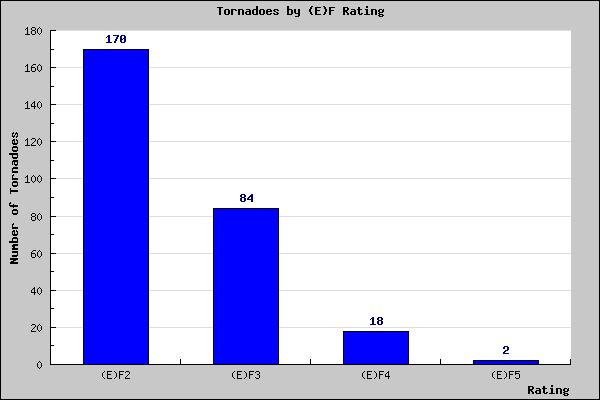
8 Tornado Distribution
, Northeast (Purple), Southeast (Green), Southern Plains (Red), West")
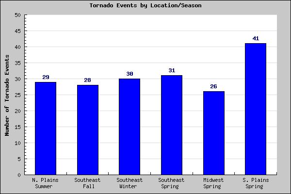
9 Tornado Distribution Geographic Regions: Northern Plains (Yellow), Midwest (Blue), Northeast (Purple), Southeast (Green), Southern Plains (Red), West (Brown)
10 Tornado Distribution

11 Results Key Parameters Cooling at 700 hpa Warming & Moistening at low-levels
12 Results Key Parameters 12-hour Wind Change 10 perc: 18 deg Avg: -6 deg 90 perc: -28 deg Miller Comparison Strong Threshold Moderate Threshold Wind Change Negative Backing w/ time Positive Veering w/ time


13 Results Key Parameters 12-hour Wind Change 10 perc: 20 deg Avg: -4 deg 90 perc: -25 deg Miller Comparison Strong Threshold Moderate Threshold Wind Change Negative Backing w/ time Positive Veering w/ time

14 Results Key Parameters 12-hour Wind Change 10 perc: 33 deg Avg: -3 deg 90 perc: -46 deg Miller Comparison Strong Threshold Moderate Threshold Wind Change Negative Backing w/ time Positive Veering w/ time

15 Results Key Parameters

16 Results Key Parameters

17 Results Synoptic Patterns

18 Results Synoptic Patterns 54% 4% 11% 7% 17% 7%

19 Results Synoptic Patterns 29% 35% 31%

20 Results Synoptic Patterns Southwesterly Jet at 500 hpa Strong Surface Low Mod./Int. Amplified Trough Closed 500 hpa Height Contours Southwesterly at 500 hpa Weak Surface Low 28% 500 hpa Westerlies Weak Surface Low 31% 500 hpa Westerlies Strong Surface Low 18% 14% 9%
21 Conclusions Key parameters and synoptic patterns from Miller (1972) were largely replicated Slight adjustments of parameters for significant tornadoes needed Clarifications for upper level jet, and height falls may also be of use Possibly separate pattern D (closed heights at 500 hpa) into more than one pattern to distinguish between extreme synoptic events and cold core low tornadoes Always a few outlier patterns that do not fit directly into synoptic patterns (i.e. northwest flow events)
22 Further Research Addition of (E)F0 and (E)F1 tornadoes, and a comparison of the synoptic environment between weak and significant tornado events Viewing all severe weather events (hail/wind), and comparing synoptic environments between non-tornado producing events and the tornado producing events
23 Acknowledgements Heather Moser from the University of Oklahoma for her help with Python scripting to use with the RUC gridded analysis files. Also to my mentor s colleague Rich Thompson (SPC) for his aid in the development of this thesis topic, and for additional research opportunities.
24 Questions? Thank you Jayson Prentice ( japrenti@iastate.edu) For the complete undergraduate thesis paper, visit
Synoptic Environments Associated with Significant Tornadoes in the Contiguous United States
 Synoptic Environments Associated with Significant Tornadoes in the Contiguous United States JAYSON A. PRENTICE Department of Geological and Atmospheric Sciences, Iowa State University, Ames, IA Mentor:
P4.479 A DETAILED ANALYSIS OF SPC HIGH RISK OUTLOOKS,
 P4.479 A DETAILED ANALYSIS OF SPC HIGH RISK OUTLOOKS, 2003-2009 Jason M. Davis*, Andrew R. Dean 2, and Jared L. Guyer 2 Valparaiso University, Valparaiso, IN 2 NOAA/NWS Storm Prediction Center, Norman,
An Analysis of 500 hpa Height Fields and Zonal Wind: Examination of the Rossby Wave Theory
 An Analysis of 500 hpa Height Fields and Zonal Wind: Examination of the Rossby Wave Theory Justin Hayward, Chris MacIntosh, Katherine Meinig Department of Geologic and Atmospheric Sciences, Iowa State
Synoptic Meteorology II: Frontogenesis Examples Figure 1
 Synoptic Meteorology II: Frontogenesis Examples The below images, taken from the 1200 UTC 17 January 2019 GFS forecast run, provide examples of the contributions of deformation and divergence to frontogenesis.
Module 11: Meteorology Topic 5 Content: Weather Maps Notes
 Introduction A variety of weather maps are produced by the National Weather Service and National Oceanographic Atmospheric Administration. These maps are used to help meteorologists accurately predict
Mesoscale Meteorology Assignment #3 Q-G Theory Exercise. Due 23 February 2017
 Mesoscale Meteorology Assignment #3 Q-G Theory Exercise 1. Consider the sounding given in Fig. 1 below. Due 23 February 2017 Figure 1. Skew T-ln p diagram from Tallahassee, FL (TLH). The observed temperature
Multi-day severe event of May 2013
 Abstract: Multi-day severe event of 18-22 May 2013 By Richard H. Grumm and Charles Ross National Weather Service State College, PA A relatively slow moving Trough over the western United States and a ridge
CASE STUDY OF THE NOVEMBER WINDSTORM IN SOUTH CENTRAL COLORADO
 32 CASE STUDY OF THE 12-13 NOVEMBER WINDSTORM IN SOUTH CENTRAL COLORADO Paul Wolyn * NOAA/NWS Pueblo, CO 1. INTRODUCTION During the evening and early morning of 12-13 November 2011, a damaging downslope
DEPARTMENT OF EARTH & CLIMATE SCIENCES SAN FRANCISCO STATE UNIVERSITY. Metr Fall 2014 Test #1 September 30, 2014
 DEPARTMENT OF EARTH & CLIMATE SCIENCES SAN FRANCISCO STATE UNIVERSITY NAME Metr 302.02 Fall 2014 Test #1 September 30, 2014 200 pts (4 pts each answer) Part I. Surface Chart Interpretation. Questions 1
and 24 mm, hPa lapse rates between 3 and 4 K km 1, lifted index values
 3.2 Composite analysis 3.2.1 Pure gradient composites The composite initial NE report in the pure gradient northwest composite (N = 32) occurs where the mean sea level pressure (MSLP) gradient is strongest
Case Study 3: Dryline in TX and OK 3 May 1999
 Case Study 3: Dryline in TX and OK 3 May 1999 Brandy Lumpkins Department of Atmospheric and Oceanic Sciences University of Wisconsin Madison 8 May 2006 ABSTRACT A massive tornadic outbreak swept across
Determining Environmental Parameters Most Important for Significant Cool Season Tornadoes across the Gulf Coastal States
 Determining Environmental Parameters Most Important for Significant Cool Season Tornadoes across the Gulf Coastal States Kar retta Venable Jackson State University, Jackson, MS Mentors David Imy NOAA/NWS/NCEP/Storm
ANSWER KEY. Part I: Synoptic Scale Composite Map. Lab 12 Answer Key. Explorations in Meteorology 54
 ANSWER KEY Part I: Synoptic Scale Composite Map 1. Using Figure 2, locate and highlight, with a black dashed line, the 500-mb trough axis. Also, locate and highlight, with a black zigzag line, the 500-mb
Global Wind Patterns
 Name: Earth Science: Date: Period: Global Wind Patterns 1. Which factor causes global wind patterns? a. changes in the distance between Earth and the Moon b. unequal heating of Earth s surface by the Sun
Boundary-layer Decoupling Affects on Tornadoes
 Boundary-layer Decoupling Affects on Tornadoes Chris Karstens ABSTRACT The North American low-level jet is known to have substantial impacts on the climatology of central and eastern regions of the United
DETERMINING USEFUL FORECASTING PARAMETERS FOR LAKE-EFFECT SNOW EVENTS ON THE WEST SIDE OF LAKE MICHIGAN
 DETERMINING USEFUL FORECASTING PARAMETERS FOR LAKE-EFFECT SNOW EVENTS ON THE WEST SIDE OF LAKE MICHIGAN Bradley M. Hegyi National Weather Center Research Experiences for Undergraduates University of Oklahoma,
Synoptic Meteorology I: Isoplething Example. From page 15 of Meteorological Data and an Introduction to Synoptic Analysis,
 Synoptic Meteorology I: Isoplething Example Overview On the following pages, isoplethed analyses of sea-level pressure (every 4 hpa; Figure 1), 2-m temperature (every 5 F; Figure 2), 2-m dew point temperature
THE SYNOPTIC ENVIRONMENT OF THE 11 APRIL 2001 CENTRAL PLAINS TORNADO OUTBREAK VIEWED IN THREE DIMENSIONS
 P1.1 THE SYNOPTIC ENVIRONMENT OF THE 11 APRIL 2001 CENTRAL PLAINS TORNADO OUTBREAK VIEWED IN THREE DIMENSIONS Daniel D. Nietfeld * NOAA/NWS/WFO Omaha/Valley, NE 1. INTRODUCTION A powerful low pressure
Synoptic Meteorology II: Petterssen-Sutcliffe Development Theory Application March 2015
 Synoptic Meteorology II: Petterssen-Sutcliffe Development Theory Application 10-12 March 2015 In our lecture on Petterssen-Sutcliffe Development Theory, we outlined the principle of selfdevelopment in
Summary of November Central U.S. Winter Storm By Christopher Hedge
 Summary of November 12-13 2010 Central U.S. Winter Storm By Christopher Hedge Event Overview The first significant snowfall of the 2010-2011 season affected portions of the plains and upper Mississippi
P3.17 THE DEVELOPMENT OF MULTIPLE LOW-LEVEL MESOCYCLONES WITHIN A SUPERCELL. Joshua M. Boustead *1 NOAA/NWS Weather Forecast Office, Topeka, KS
 P3.17 THE DEVELOPMENT OF MULTIPLE LOW-LEVEL MESOCYCLONES WITHIN A SUPERCELL Joshua M. Boustead *1 NOAA/NWS Weather Forecast Office, Topeka, KS Philip N. Schumacher NOAA/NWS Weather Forecaster Office, Sioux
San Francisco State University Department of Earth & Climate Sciences Fall 2017
 San Francisco State University Name Department of Earth & Climate Sciences Fall 2017 Part 1: Fronts Final Inclass Exercise (Inclass Exercise 11) Diagnosing Fronts and Upper Tropospheric Divergence Patterns
Severe Weather with a strong cold front: 2-3 April 2006 By Richard H. Grumm National Weather Service Office State College, PA 16803
 Severe Weather with a strong cold front: 2-3 April 2006 By Richard H. Grumm National Weather Service Office State College, PA 16803 1. INTRODUCTION A strong cold front brought severe weather to much of
Comparison of November 15, 2008 Killer Tornado Outbreak with the December 2, 2009 Non Tornado Event
 Comparison of November 15, 2008 Killer Tornado Outbreak with the December 2, 2009 Non Tornado Event The two events featured similar patterns but with much different results in central NC. The slides on
Name SOLUTIONS T.A./Section Atmospheric Science 101 Homework #6 Due Thursday, May 30 th (in class)
") Name SOLUTIONS T.A./Section Atmospheric Science 101 Homework #6 Due Thursday, May 30 th (in class) 1. General Circulation Briefly describe where each of the following features is found in the earth s general
Name SOLUTIONS T.A./Section Atmospheric Science 101 Homework #6 Due Thursday, May 30 th (in class) 1. General Circulation Briefly describe where each of the following features is found in the earth s general
Weather Station Model
 Fun with Weather Maps! (no, really stop laughing) AOSC 200 Tim Canty Class Web Site: http://www.atmos.umd.edu/~tcanty/aosc200 Topics for today: Station Model Temperature Maps Pressure Maps Fronts Lecture
Can the Convective Temperature from the 12UTC Sounding be a Good Predictor for the Maximum Temperature, During the Summer Months?
 Meteorology Senior Theses Undergraduate Theses and Capstone Projects 12-1-2017 Can the Convective Temperature from the 12UTC Sounding be a Good Predictor for the Maximum Temperature, During the Summer
INTEGRATED TURBULENCE FORECASTING ALGORITHM 2001 METEOROLOGICAL EVALUATION
 INTEGRATED TURBULENCE FORECASTING ALGORITHM 2001 METEOROLOGICAL EVALUATION Jeffrey A. Weinrich* Titan Systems Corporation, Atlantic City, NJ Danny Sims Federal Aviation Administration, Atlantic City, NJ
MJO Influence in Continental United States Temperatures
 MJO Influence in Continental United States Temperatures An honors thesis presented to the Department of Atmospheric Science, University at Albany, State University Of New York in partial fulfillment of
True or false: The atmosphere is always in hydrostatic balance. A. True B. False
 Clicker Questions and Clicker Quizzes Clicker Questions Chapter 7 Of the four forces that affect the motion of air in our atmosphere, which is to thank for opposing the vertical pressure gradient force
NAM-WRF Verification of Subtropical Jet and Turbulence
 National Weather Association, Electronic Journal of Operational Meteorology, 2008-EJ3 NAM-WRF Verification of Subtropical Jet and Turbulence DOUGLAS N. BEHNE National Weather Service, Aviation Weather
Exploring the Accuracy of the North American Mesoscale Model during Low-Level Jet Influenced Convection in Iowa
 Meteorology Senior Theses Undergraduate Theses and Capstone Projects 12-2016 Exploring the Accuracy of the North American Mesoscale Model during Low-Level Jet Influenced Convection in Iowa Nickolas V.
Custom Weather Forecast
 1 of 23 Custom Weather Forecast 2018 Chicago Yacht Club s Race To Mackinac- Cruising Division Disclaimer: The user assumes all risk related to the use of this Custom Weather Forecast. The crew of the participating
Impacts of the April 2013 Mean trough over central North America
 Impacts of the April 2013 Mean trough over central North America By Richard H. Grumm National Weather Service State College, PA Abstract: The mean 500 hpa flow over North America featured a trough over
Synoptic Meteorology I: Lab 1 Discussion. 25 September From page 14 of Meteorological Data and an Introduction to Synoptic Analysis,
 Synoptic Meteorology I: Lab 1 Discussion 25 September 2014 Overview On the following pages, isoplethed analyses of sea-level pressure (every 4 hpa; Figure 1), 2-m temperature (every 5 F; Figure 2), 2-m
Appalachian Lee Troughs and their Association with Severe Thunderstorms
 Appalachian Lee Troughs and their Association with Severe Thunderstorms Daniel B. Thompson, Lance F. Bosart and Daniel Keyser Department of Atmospheric and Environmental Sciences University at Albany/SUNY,
Joshua M. Boustead *1, and Barbara E. Mayes NOAA/NWS WFO Omaha/Valley, NE. William Gargan, George Phillips, and Jared Leighton NOAA/NWS WFO Topeka, KS
 7B.3 Composite Analysis of Environmental Conditions Favorable for Significant Tornadoes across Eastern Kansas Joshua M. Boustead *1, and Barbara E. Mayes NOAA/NWS WFO Omaha/Valley, NE William Gargan, George
Southern Plains Heavy rain and Flooding
 Abstract: Southern Plains Heavy rain and Flooding By Richard H. Grumm National Weather Service State College, PA A severe weather event affected the southern Plains on 31 May 2013. The severe weather event
THE SUMMER STUDENT VOLUNTEER PROGRAM AT NWS WFO BALTIMORE/WASHINGTON
 THE SUMMER STUDENT VOLUNTEER PROGRAM AT NWS WFO BALTIMORE/WASHINGTON Matthew R. Kramar, Andrew B. Woodcock, Jared R. Klein and Steven M. Zubrick NOAA/National Weather Service Weather Forecast Office Baltimore/Washington
UNITED STATES AND SOUTH AMERICA OUTLOOK (FULL REPORT) Wednesday, April 18, 2018
 Wednesday, April 18, 2018") T-storm Weather Summary Coolness continues over the next week in much of the central U.S., most likely producing the coldest April since 1907 in the Corn Belt, but followed by seasonable to mild weather
T-storm Weather Summary Coolness continues over the next week in much of the central U.S., most likely producing the coldest April since 1907 in the Corn Belt, but followed by seasonable to mild weather
Fronts in November 1998 Storm
 Fronts in November 1998 Storm Much of the significant weather observed in association with extratropical storms tends to be concentrated within narrow bands called frontal zones. Fronts in November 1998
Module 9 Weather Systems
 Module 9 Weather Systems In this module the theory of atmospheric dynamics is applied to different weather phenomena. The first section deals with extratropical cyclones, low and high pressure areas of
Lab 19.2 Synoptic Weather Maps
 Lab 19.2 Synoptic Weather Maps Name: Partner: Purpose The purpose of this lab is to have you read and interpret the information displayed on synoptic weather maps. You will also learn the techniques used
Multiscale Analyses of Inland Tropical Cyclone Midlatitude Jet Interactions: Camille (1969) and Danny (1997)
 and Danny (1997)") Multiscale Analyses of Inland Tropical Cyclone Midlatitude Jet Interactions: Camille (1969) and Danny (1997) Matthew Potter, Lance Bosart, and Daniel Keyser Department of Atmospheric and Environmental
Multiscale Analyses of Inland Tropical Cyclone Midlatitude Jet Interactions: Camille (1969) and Danny (1997) Matthew Potter, Lance Bosart, and Daniel Keyser Department of Atmospheric and Environmental
Final Examination, MEA 443 Fall 2008, Lackmann
 Place an X here to count it double! Name: Final Examination, MEA 443 Fall 2008, Lackmann If you wish to have the final exam count double and replace your midterm score, place an X in the box above. As
The dynamics of high and low pressure systems
 The dynamics of high and low pressure systems Newton s second law for a parcel of air in an inertial coordinate system (a coordinate system in which the coordinate axes do not change direction and are
Examination #3 Wednesday, 28 November 2001
 Name & Signature Dr. Droegemeier Student ID Meteorology 1004 Introduction to Meteorology Fall, 2001 Examination #3 Wednesday, 28 November 2001 BEFORE YOU BEGIN!! Please be sure to read each question CAREFULLY
On the usage of composite parameters in High-Shear, Low-CAPE environments
 P72 On the usage of composite parameters in High-Shear, Low-CAPE environments Keith D. Sherburn* and Matthew D. Parker Department of Marine, Earth, and Atmospheric Sciences, North Carolina State University,
ENSO: Recent Evolution, Current Status and Predictions. Update prepared by: Climate Prediction Center / NCEP 30 October 2017
 ENSO: Recent Evolution, Current Status and Predictions Update prepared by: Climate Prediction Center / NCEP 30 October 2017 Outline Summary Recent Evolution and Current Conditions Oceanic Niño Index (ONI)
Quasi-Geostrophic Implications
 Chapter 10 Quasi-Geostrophic Implications When you look at a weather chart with all its isolines and plotted data, you need a framework upon which to interpret what you see. Quasi-geostrophic theory provides
P1.20 AN ANALYSIS OF SYNOPTIC PATTERNS ASSOCIATED WITH STRONG NORTH TEXAS COLD FRONTS DURING THE COLD SEASON
 P1.20 AN ANALYSIS OF SYNOPTIC PATTERNS ASSOCIATED WITH STRONG NORTH TEXAS COLD FRONTS DURING THE 2005-06 COLD SEASON Stacie Hanes* and Gregory R. Patrick NOAA/NWS Weather Forecast Office Fort Worth, TX
Extremely cold weather events caused by arctic air mass and its synoptic situation in Finland from the year 1950 onwards
 Extremely cold weather events caused by arctic air mass and its synoptic situation in Finland from the year 1950 onwards Senior meteorologist Henri Nyman Finnish Meteorological Institute, Weather and Safety
National Weather Service-Pennsylvania State University Weather Events
 National Weather Service-Pennsylvania State University Weather Events Historic Ohio Valley January Severe weather and Tornado Event by Richard H. Grumm National Weather Service State College PA 16803 and
A Synoptic Climatology of Heavy Precipitation Events in California
 A Synoptic Climatology of Heavy Precipitation Events in California Alan Haynes Hydrometeorological Analysis and Support (HAS) Forecaster National Weather Service California-Nevada River Forecast Center
Vertical structure. To conclude, we will review the critical factors invloved in the development of extratropical storms.
 Vertical structure Now we will examine the vertical structure of the intense baroclinic wave using three visualization tools: Upper level charts at selected pressure levels Vertical soundings for selected
Synoptic situations of severe local convective storms during the pre-monsoon season in Bangladesh
 INTERNATIONAL JOURNAL OF CLIMATOLOGY Int. J. Climatol. 33: 725 734 (2013) Published online 13 March 2012 in Wiley Online Library (wileyonlinelibrary.com) DOI: 10.1002/joc.3460 Synoptic situations of severe
April 13, 2006: Analysis of the Severe Thunderstorms that produced Hail in Southern Wisconsin
 April 13, 2006: Analysis of the Severe Thunderstorms that produced Hail in Southern Wisconsin Danielle Triolo UW Madison Undergraduate 453 Case Study May 5, 2009 ABSTRACT On April 13, 2006 the states of
Early May Cut-off low and Mid-Atlantic rains
 Abstract: Early May Cut-off low and Mid-Atlantic rains By Richard H. Grumm National Weather Service State College, PA A deep 500 hpa cutoff developed in the southern Plains on 3 May 2013. It produced a
daily (0000, 0600, 1200, and 1800 UTC) National Centers for Environmental
 National Centers for Environmental") 2. Data and Methodology 2.1 Data Sources A climatology of and categorization scheme for ALTs during the warm season (defined here as May September) were developed using gridded data from the four times
2. Data and Methodology 2.1 Data Sources A climatology of and categorization scheme for ALTs during the warm season (defined here as May September) were developed using gridded data from the four times
Mid Atlantic Severe Event of 1 May 2017 Central Pennsylvania QLCS event By Richard H. Grumm National Weather Service, State College, PA 16803
 1. Overview Mid Atlantic Severe Event of 1 May 2017 Central Pennsylvania QLCS event By Richard H. Grumm National Weather Service, State College, PA 16803 A strong upper-level wave (Fig.1) moving into a
Fun with Weather Maps! (no, really stop laughing) AOSC 200 Tim Canty
 AOSC 200 Tim Canty") Fun with Weather Maps! (no, really stop laughing) AOSC 200 Tim Canty Class Web Site: http://www.atmos.umd.edu/~tcanty/aosc200 Topics for today: Observations Station Model Temperature Maps Pressure Maps
Fun with Weather Maps! (no, really stop laughing) AOSC 200 Tim Canty Class Web Site: http://www.atmos.umd.edu/~tcanty/aosc200 Topics for today: Observations Station Model Temperature Maps Pressure Maps
P12.6 Multiple Modes of Convection in Moderate to High Wind Shear Environments
 P12.6 Multiple Modes of Convection in Moderate to High Wind Shear Environments Adam J. French and Matthew D. Parker North Carolina State University, Raleigh, North Carolina 1. INTRODUCTION A principle
Weather report 28 November 2017 Campinas/SP
 Weather report 28 November 2017 Campinas/SP Summary: 1) Synoptic analysis and pre-convective environment 2) Verification 1) Synoptic analysis and pre-convective environment: At 1200 UTC 28 November 2017
Chapter 1 Anatomy of a Cyclone
 Chapter 1 Anatomy of a Cyclone The Beast in the East 15-17 February 2003 Extra-tropical cyclone an area of low pressure outside of the tropics Other names for extra-tropical cyclones: Cyclone Mid-latitude
Monthly Long Range Weather Commentary Issued: July 18, 2014 Steven A. Root, CCM, President/CEO
 Monthly Long Range Weather Commentary Issued: July 18, 2014 Steven A. Root, CCM, President/CEO sroot@weatherbank.com JUNE 2014 REVIEW Climate Highlights The Month in Review The average temperature for
Weather and Climate Summary and Forecast October 2017 Report
 Weather and Climate Summary and Forecast October 2017 Report Gregory V. Jones Linfield College October 4, 2017 Summary: Typical variability in September temperatures with the onset of fall conditions evident
A Comparison of Iowa Flash Flood Events and Eight Common Features of Excessive Rainfall for BRITTANY A. KONRADI 1
 1 A Comparison of Iowa Flash Flood Events and Eight Common Features of Excessive Rainfall for 2006-2011 BRITTANY A. KONRADI 1 Mentors: Melinda Beerends 2, Dr. Kristie Franz 1 Department of Geological and
Weather and Climate Summary and Forecast Summer 2017
 Weather and Climate Summary and Forecast Summer 2017 Gregory V. Jones Southern Oregon University August 4, 2017 July largely held true to forecast, although it ended with the start of one of the most extreme
Science Olympiad Meteorology Quiz #2 Page 1 of 8
 1) The prevailing general direction of the jet stream is from west to east in the northern hemisphere: 2) Advection is the vertical movement of an air mass from one location to another: 3) Thunderstorms
Weather and Climate Summary and Forecast November 2017 Report
 Weather and Climate Summary and Forecast November 2017 Report Gregory V. Jones Linfield College November 7, 2017 Summary: October was relatively cool and wet north, while warm and very dry south. Dry conditions
INVESTIGATION FOR A POSSIBLE INFLUENCE OF IOANNINA AND METSOVO LAKES (EPIRUS, NW GREECE), ON PRECIPITATION, DURING THE WARM PERIOD OF THE YEAR
, ON PRECIPITATION, DURING THE WARM PERIOD OF THE YEAR") Proceedings of the 13 th International Conference of Environmental Science and Technology Athens, Greece, 5-7 September 2013 INVESTIGATION FOR A POSSIBLE INFLUENCE OF IOANNINA AND METSOVO LAKES (EPIRUS,
Proceedings of the 13 th International Conference of Environmental Science and Technology Athens, Greece, 5-7 September 2013 INVESTIGATION FOR A POSSIBLE INFLUENCE OF IOANNINA AND METSOVO LAKES (EPIRUS,
The 13 April 2006 Severe Thunderstorm and Large Hail Event in Iowa & Wisconsin:A Case Study
 The 13 April 2006 Severe Thunderstorm and Large Hail Event in Iowa & Wisconsin:A Case Study David M. DeMeuse Undergraduate University of Wisconsin Department of Atmospheric & Oceanic Science Mesoscale
REGIONAL VARIABILITY OF CAPE AND DEEP SHEAR FROM THE NCEP/NCAR REANALYSIS ABSTRACT
 REGIONAL VARIABILITY OF CAPE AND DEEP SHEAR FROM THE NCEP/NCAR REANALYSIS VITTORIO A. GENSINI National Weather Center REU Program, Norman, Oklahoma Northern Illinois University, DeKalb, Illinois ABSTRACT
Example of the one month forecast
 Example of the one month forecast Masayuki Hirai Tokyo Climate Center (TCC)/ Climate Prediction Division of Japan Meteorological Agency (JMA) Example Note that the initial time and the forecast target
CHAPTER 9 ATMOSPHERE S PLANETARY CIRCULATION MULTIPLE CHOICE QUESTIONS
 CHAPTER 9 ATMOSPHERE S PLANETARY CIRCULATION MULTIPLE CHOICE QUESTIONS 1. Viewed from above in the Northern Hemisphere, surface winds about a subtropical high blow a. clockwise and inward. b. counterclockwise.
A COMPREHENSIVE 5-YEAR SEVERE STORM ENVIRONMENT CLIMATOLOGY FOR THE CONTINENTAL UNITED STATES 3. RESULTS
 16A.4 A COMPREHENSIVE 5-YEAR SEVERE STORM ENVIRONMENT CLIMATOLOGY FOR THE CONTINENTAL UNITED STATES Russell S. Schneider 1 and Andrew R. Dean 1,2 1 DOC/NOAA/NWS/NCEP Storm Prediction Center 2 OU-NOAA Cooperative
Influence of Topography on Convective. Patterns across the Greater Capital Region of. New York
 Influence of Topography on Convective Patterns across the Greater Capital Region of New York Honors College Undergraduate Research Thesis (8 May 2016) Rachel O Donnell and Professor Brian Tang Department
The Greensburg, KS Tornado
 J2.4 The Greensburg, KS Tornado Daniel McCarthy NOAA Storm Prediction Center Norman, OK Larry Ruthi and Jeff Hutton NWS Weather Forecast Office Dodge City, KS 1. Background The tornado that moved through
Special blog on winter 2016/2017 retrospective can be found here -
 March 4, 2019 Special blog on winter 2016/2017 retrospective can be found here - http://www.aer.com/winter2017 Special blog on winter 2015/2016 retrospective can be found here - http://www.aer.com/winter2016
The project that I originally selected to research for the OC 3570 course was based on
 Introduction The project that I originally selected to research for the OC 3570 course was based on remote sensing applications of the marine boundary layer and their verification with actual observed
ESCI 1010 Lab 6 Midlatitude Cyclones and Thunderstorms
 ESCI 1010 Lab 6 Midlatitude Cyclones and Thunderstorms Before Lab: Review pages 244-324 in your Weather and Climate textbook. Pay special attention to the sections entitled Fronts, Life Cyclone of a Midlatitude
1/18/2011. From the hydrostatic equation, it is clear that a single. pressure and height in each vertical column of the atmosphere.
 Lecture 3: Applications of Basic Equations Pressure as Vertical Coordinate From the hydrostatic equation, it is clear that a single valued monotonic relationship exists between pressure and height in each
Class exercises Chapter 3. Elementary Applications of the Basic Equations
 Class exercises Chapter 3. Elementary Applications of the Basic Equations Section 3.1 Basic Equations in Isobaric Coordinates 3.1 For some (in fact many) applications we assume that the change of the Coriolis
The Behaviour of the Atmosphere
 3 The Behaviour of the Atmosphere Learning Goals After studying this chapter, students should be able to: apply the ideal gas law and the concept of hydrostatic balance to the atmosphere (pp. 49 54); apply
ABSTRACT 1.-INTRODUCTION
 Characterization of wind fields at a regional scale calculated by means of a diagnostic model using multivariate techniques M.L. Sanchez, M.A. Garcia, A. Calle Laboratory of Atmospheric Pollution, Dpto
Examples of Pressure Gradient. Pressure Gradient Force. Chapter 7: Forces and Force Balances. Forces that Affect Atmospheric Motion 2/2/2015
 Chapter 7: Forces and Force Balances Forces that Affect Atmospheric Motion Fundamental force - Apparent force - Pressure gradient force Gravitational force Frictional force Centrifugal force Forces that
Evidence Linking Arctic Amplification with Changing Weather Patterns in Mid-Latitudes
 Evidence Linking Arctic Amplification with Changing Weather Patterns in Mid-Latitudes Jennifer Francis Institute of Marine and Coastal Sciences Rutgers, the State University of New Jersey Steve Vavrus
11A.2 Forecasting Short Term Convective Mode And Evolution For Severe Storms Initiated Along Synoptic Boundaries
 11A.2 Forecasting Short Term Convective Mode And Evolution For Severe Storms Initiated Along Synoptic Boundaries Greg L. Dial and Jonathan P. Racy Storm Prediction Center, Norman, Oklahoma 1. Introduction
A Preliminary Climatology of Tornado Events with Closed Cold Core 500 mb Lows in the Central and Eastern United States
 7B.4 A Preliminary Climatology of Tornado Events with Closed Cold Core 500 mb Lows in the Central and Eastern United States Jonathan M. Davies* Private Meteorologist, Wichita, Kansas Jared L. Guyer Storm
Hydrostatic Equation and Thermal Wind. Meteorology 411 Iowa State University Week 5 Bill Gallus
 Hydrostatic Equation and Thermal Wind Meteorology 411 Iowa State University Week 5 Bill Gallus Hydrostatic Equation In the atmosphere, vertical accelerations (dw/dt) are normally fairly small, and we can
Weather Outlook: 2015 Growing Season
 Weather Outlook: 2015 Growing Season Leon F. Osborne Chester Fritz Distinguished Professor Regional Weather Information Center University of North Dakota Grand Forks, North Dakota Why Should We Be Concerned?
Weather, Air Masses, Fronts and Global Wind Patterns. Meteorology
 Weather, Air Masses, Fronts and Global Wind Patterns Meteorology Weather is what conditions of the atmosphere are over a short period of time. Climate is how the atmosphere "behaves" over long periods
Synoptic Meteorology
 M.Sc. in Meteorology Synoptic Meteorology [MAPH P312] Prof Peter Lynch Second Semester, 2004 2005 Seminar Room Dept. of Maths. Physics, UCD, Belfield. Part 9 Extratropical Weather Systems These lectures
The Integration of WRF Model Forecasts for Mesoscale Convective Systems Interacting with the Mountains of Western North Carolina
 Proceedings of The National Conference On Undergraduate Research (NCUR) 2006 The University of North Carolina at Asheville Asheville, North Carolina April 6-8, 2006 The Integration of WRF Model Forecasts
2 July 2013 Flash Flood Event
 2 July 2013 Flash Flood Event By Richard H. Grumm and Charles Ross National Weather Service State College, PA 1. Overview A retrograding 500 hpa cyclone and anticyclone (Fig. 1) set up deep southerly flow
 Identification of Predictors for Nowcasting Heavy Rainfall In Taiwan --------------------- Part II: Storm Characteristics and Nowcasting Applications Challenges in Developing Nowcasting Applications for
The Boundary Layer and Related Phenomena
 The Boundary Layer and Related Phenomena Jeremy A. Gibbs University of Oklahoma gibbz@ou.edu February 19, 2015 1 / 49 Overview Nocturnal Low-Level Jets Introduction Climatology of LLJs Meteorological Importance
MDA WEATHER SERVICES AG WEATHER OUTLOOK. Kyle Tapley-Senior Agricultural Meteorologist May 22, 2014 Chicago, IL
 MDA WEATHER SERVICES AG WEATHER OUTLOOK Kyle Tapley-Senior Agricultural Meteorologist May 22, 2014 Chicago, IL GLOBAL GRAIN NORTH AMERICA 2014 Agenda Spring Recap North America Forecast El Niño Discussion
Unit Three Worksheet Meteorology/Oceanography 2 WS GE U3 2
 Unit Three Worksheet Meteorology/Oceanography 2 WS GE U3 2 Name Period Section 17.3 1. 2. 3. 4. 5. 6. 7. 8. Of the following, which is NOT a factor that controls temperature? (C) latitude (D) longitude
Fog Hazards in Punjab
 Pakistan Journal of Meteorology Vol. 8, Issue 16: Jan, 2012 Fog Hazards in Punjab Aslam, M. 1 Abstract Using 30-year (1976-2005) real meteorological data of 10-weather stations, four dense fog years (1998-1999,