Weather Forecast Interpretation for Boaters. Cindy Yu Feb 14 th, 2018 Meteorological Service of Canada
|
|
|
- Geoffrey Wade
- 5 years ago
- Views:
Transcription
1 Weather Forecast Interpretation for Boaters Cindy Yu Feb 14 th, 2018 Meteorological Service of Canada


 OSPC")
2 Environment Canada s Forecast Regions & Offices PSPC CMC NFSPC PASPC (Edmonton) & CMAC-W PASPC (Winnipeg) OSPC QSPC&CMAC-E ASPC&CHC


3 Where do your marine forecasts come from? Pacific Storm Prediction Centre Downtown Vancouver

4 Integrated Forecaster Workstation NinJo is installed on the new workstation 3 monitors / 1 tablet New adjustable desks
5 History of the PSPC Created in 2003 as a result of a restructuring of the weather offices (aim was for one office per region) Merger of the Pacific Weather Centre already in Vancouver (PWC) and the Mountain Weather Centre (MWC) in Kelowna.
6 Present Day 32 forecasters work in the PSPC 2 desks staffed 24hrs - Supervisor (Public Yukon), Marine 1.5 desks staffed 20.5hrs Public Coast, Public Interior Consultation desk staffed 20.5 hours

7 Public Forecast Regions 3 Forecasters Yukon Interior Coast

8 Marine Forecast Regions

9 Today s talk will cover: What causes wind? How do we measure wind? Effects of terrain on wind Waves Wind Warnings Interpreting the forecast

10 WHAT CAUSES WIND?
11 What Causes Wind? Coriolis Force Pressure Gradient
")
12 Air movement L Coriolis force deflects the air to the right (in Northern Hemisphere) H


13 Wind = pressure differences Air flows toward low pressure

14 Pressure Gradient Isobars are lines of equal pressure Closer the lines = great the change in pressure = greater the Pressure Gradient = stronger the winds
15 Geostrophic Wind Pressure Gradient Coriolis Force

16 1 The Strait of Georgia Winds are heavily channelled by terrain
17 Variability..! Unlike any other body of water in Canada

18 HOW DO WE MEASURE WIND?


19 19 Measuring The Wind

20 Which wind are you measuring? Measurement heights are WMO standards

21 Land-based Automatic Weather Stations Anemometer height: 10 metres above ground 21

22 Lightkeeper Marine Weather Reports lightstations report every 3 hours during daytime Some lightkeepers estimate the wind

23 Moored Buoys 3-metre Discus ~ 5 metres above the water 23

24 Ship vs Buoy Anemometers

25 Which wind are you talking about?

26 A Marine Wind Observation SE20G30 southeast 20 gusting 30 knots 20 is the sustained wind 26
27 Land-based Weather Stations the sustained wind is a 2-minute averaged wind
28 Land-based Weather Stations the gust is the highest 5-second average
29 Wind measurements/averaging
 20 15 10 5 30 60 90 120 150 180 210 30 Time")
30 Buoys the sustained wind is the 10-minute average wind 30 1-sec wind max = Wind Speed (knots) Time (seconds)

31 A Rule for Buoy Winds Warning thresholds are lower for buoys
32 Wind Measurement Realities Wind is measured at different heights, over different surfaces (land and water) at different times. Using different instruments, and averaged over different periods. Some stations are favoured over others because the forecast is for the strongest wind expected in that marine region. The bottom-line: meteorologists use the observations available to them to assist in forecasting.

33 Actual Wind Observations EFFECTS OF TERRAIN, & SIZE OF FORECAST AREA ON WIND
34 Peak Winds Wind Speed (knots) Time (seconds)
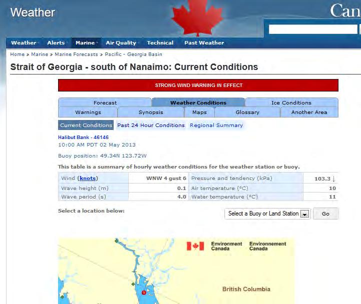
35 Peak Winds!!! Douglas Channel Buoy = Nanakwa Shoal Sustained 34KT 48KT 64KT Strait of Georgia Buoys = Sentry Shoal = Halibut Bank 20KT 34KT 48KT 64KT


36 Qualicum Winds High-resolution models may capture

37 Synthetic Aperture Radar Winds (SAR Winds) High-resolution satellite image of ocean surface winds

38 Waves Peaks and Periods
39 Wave Height
40 Buoys Significant wave heights, maximum wave, wave period

41 Wave terms Hsignificant, Hpeak For any sufficient sample of waves Wave Forecast

42 A Wave Forecast
43 Peak Wave Frequency How often to expect the Peak Wave? Given Hsig = 5m 1 wave in 10 may be ~ 5m 1 wave in 1000 may be ~ 10m
44 Wave Period
45 Significant Wave Period If a buoy measures a Wave Period of 6 seconds, Then on the water: - 10 waves pass every minute waves pass every hour (1200 in 2 hours) If a Peak Wave occurs every 1000 waves, then given a wave period of 6 seconds, you may encounter one about every 2 hours.

46 WIND WARNINGS

47 Poll for Marine Wind Warnings

48 Poll for Marine Wind Warnings


49 Strong Wind Warning Previously known as Small Craft Advisory Sustained Winds of: knots US: ONLY ISSUED March 20 th to Remembrance Day


50 Gale Force Wind Warning Sustained Winds of: knots

51 Storm Force Wind Warning Sustained Winds of: knots

52 Hurricane Force Wind Warning Sustained Winds of: 64+ knots
53 Know your Wind Warnings!! Warning Level Wind Strength (knots) Strong Gale Storm Hurricane 64+
54 INTERPRETING THE FORECAST Where will the strongest winds be observed and can I avoid them?

55 Marginal Gales:

56 Marginal Gales.
57 Interpreting the Forecast Getting the most out of: Use both public & marine forecasts!
58

59

60

61

62

63
64

65
66 66 Forecast Time References
67 Weather information by telephone Speak with marine forecaster anytime <FREE & 24/7> o Speak with a public forecaster (6am to 9pm weekdays, 10am to 6pm weekends & holidays) <FREE * 3am 9pm> o Recorded marine weather o o Howe Sound, Strait of Georgia/Juan De Fuca 67

68 Weather Rules of Thumb How to forecast your own weather

69 Weather Forecasting Hints Deteriorating weather : Barometer is falling Temperature change & humidity increase Cirrus clouds increasing Clouds darken and develop multiple layers Strong winds in morning with a shift to SE Red sky at morning

70 Weather Forecasting Hints Improving weather : Barometer is rising Winds steady or shifting to W or NW Steady temperature Early morning clouds or fog burn off Shallow cumulus or thin high clouds Red sky at night

71 Avalanche Blog Created daily, 365 days a year Synopsis Day 1-7 Forecast /weather/forecast

72 PSPC Alerts Dissemination /warnings EC Alert Me ECCC Weather BC
73 Free Online Resources Guide to marine weather forecasts canada.ca

74 For further information Cindy Yu
Inflow and Outflow through the Sea-to-Sky Corridor in February 2010: Lessons Learned from SNOW-V10 *
 Inflow and Outflow through the Sea-to-Sky Corridor in February 2010: Lessons Learned from SNOW-V10 * Ruping Mo National Laboratory for Coastal and Mountain Meteorology, Environment Canada, Vancouver, BC,
P9.17 USING SAR WINDS TO EVALUATE SYNOPTIC AND MESOSCALE FEATURES IN FORECAST OPERATIONS
 P9.17 USING SAR WINDS TO EVALUATE SYNOPTIC AND MESOSCALE FEATURES IN FORECAST OPERATIONS Kenneth Chan, Brad Snyder, Laurie Neil Meteorological Service of Canada,, B.C., Canada 1. INTRODUCTION A national
Exercise Brunswick ALPHA 2018
 ALPHA Exercise Brunswick ALPHA 2018 Who we are (our structure) What we do (our forecasts) How you can access the information Tropical cyclone information (basic) Overview of the products used for Exercise
WEATHER FORECASTING Acquisition of Weather Information WFO Regions Weather Forecasting Tools Weather Forecasting Tools Weather Forecasting Methods
 1 2 3 4 5 6 7 8 WEATHER FORECASTING Chapter 13 Acquisition of Weather Information 10,000 land-based stations, hundreds of ships and buoys; four times a day, airports hourly Upper level: radiosonde, aircraft,
CHAPTER 13 WEATHER ANALYSIS AND FORECASTING MULTIPLE CHOICE QUESTIONS
 CHAPTER 13 WEATHER ANALYSIS AND FORECASTING MULTIPLE CHOICE QUESTIONS 1. The atmosphere is a continuous fluid that envelops the globe, so that weather observation, analysis, and forecasting require international
MASTERY ASSIGNMENT 2015
 Climate & Meteorology MASTERY ASSIGNMENT 2015 Directions: You must submit this document via Google Docs to lzimmerman@wcpss.net. The document must include the questions and pictures must be hand drawn
National Maritime Center
 National Maritime Center Providing Credentials to Mariners (Sample Examination) Page 1 of 5 Choose the best answer to the following Multiple Choice Questions. 1. In a weather report, the term "visibility"
Chapter 12: Meteorology
 Chapter 12: Meteorology Section 1: The Causes of Weather 1. Compare and contrast weather and climate. 2. Analyze how imbalances in the heating of Earth s surface create weather. 3. Describe how and where
The next page shows the six airports where Wolf examined the data loggers to come up with his conclusions.
 This image is from Wolf Reid, described as the foremost expert on Pacific Northwest storms. He is a climatologist and is currently at UBC. He has studied every storm that has hit since 1940. The image
Mr. P s Science Test!
 WEATHER- 2017 Mr. P s Science Test! # Name Date 1. Draw and label a weather station model. (10 pts) 2. The is the layer of the atmosphere with our weather. 3. Meteorologists classify clouds in about different
Setting a Straight Course RCA Weather Protocol
 Setting a Straight Course Saturday, February 25, 2006 Presenter: Andrew Cartwright, Rowing Canada Umpire Facilitator: Wayne Van Osterhout 1 2 3 WIND WAVES WEATHER & WOWING 4 written by Rob Millikin approved
National Maritime Center
 National Maritime Center Providing Credentials to Mariners (Sample Examination) Page 1 of 5 Choose the best answer to the following Multiple Choice Questions. 1. Fog is formed when which condition exists?
Unit: Weather Study Guide
 Name: Period: Unit: Weather Study Guide Define each vocabulary word on a separate piece of paper or index card. Weather Climate Temperature Wind chill Heat index Sky conditions UV index Visibility Wind
Presentation on RSMC Nadi-TCC Activities
 6 th TC RSMC Technical Coordination Meeting, Brisbane, Australia, 2 5 Nov 2009 Presentation on RSMC Nadi-TCC Activities R. Prasad Director RSMC Nadi-TCC NADI TROPICAL CYCLONE CENTRE RSMC NADI - TCC Approved
Use the terms from the following list to complete the sentences below. Each term may be used only once.
 Skills Worksheet Directed Reading Section: Air Masses Use the terms from the following list to complete the sentences below. Each term may be used only once. high pressure poles low pressure equator wind
Weather Forecasting. March 26, 2009
 Weather Forecasting Chapter 13 March 26, 2009 Forecasting The process of inferring weather from a blend of data, understanding, climatology, and solutions of the governing equations Requires an analysis
Direct Readout at the Meteorological Service of Canada
 Direct Readout at the Meteorological Service of Canada CSPP Users Meeting 2015 Darmstadt, Germany April 14-16, 2015 David Bradley Manager, Earth Observation and Geomatics Meteorological Service of Canada
Severe Weather Potential for Southeast Texas
 Severe Weather Potential for Southeast Texas Dan Reilly, Kent Prochazka, Scott Overpeck National Weather Service Houston/Galveston 10 am Synopsis Storm to likely bring severe weather to Southeast Texas
Severe Weather Objectives
 Severe Weather Objectives Describe how lightning forms. Describe the formation of thunderstorms, tornadoes, and hurricanes. Describe the characteristics of thunderstorms, tornadoes, and hurricanes. Explain
Coastal Storm Potential
 Coastal Storm Potential Event Date/Time: 11/12/2009-11/14/2009 Today through Saturday National Weather Service Newport/Morehead City, NC Date: 11/12/2009 1000 am Coastal Storm Remnants of Ida, coupled
2. What causes these weather changes?
 Weather Table of Contents Essential Questions... 1 Vocabulary... 2 Weather Symbols... 5 Bringing the Rain to Kapiti Plain... 7 Weather Instruments... 8 Weather Forecasting... 13 Essential Questions 1.
Evaporation - Water evaporates (changes from a liquid to a gas) into water vapor due to heat from the Sun.
 into water vapor due to heat from the Sun.") Erin Kathryn 2016 Weather is the conditions of Earth s atmosphere at a certain time and place. For example, sunshine, rain, hurricanes, and storms are all examples of weather. Weather is different at different
Erin Kathryn 2016 Weather is the conditions of Earth s atmosphere at a certain time and place. For example, sunshine, rain, hurricanes, and storms are all examples of weather. Weather is different at different
ATMOSPHERIC CIRCULATION AND WIND
 ATMOSPHERIC CIRCULATION AND WIND The source of water for precipitation is the moisture laden air masses that circulate through the atmosphere. Atmospheric circulation is affected by the location on the
May 17, earthsciencechapter24.notebook. Apr 8 10:54 AM Review. Grade:9th. Subject:Earth Science. Date:4/8.
 Apr 8 10:54 AM 24.1 Review Grade:9th Subject:Earth Science Date:4/8 Apr 8 9:29 AM 1 1 As lower layers of air are warmed... A the air rises B winds form C the air dries D the air sinks Apr 8 9:49 AM 2 What
NWS Operational Marine and Ocean Forecasting. Overview. Ming Ji. Ocean Prediction Center National Weather Service/NCEP. CIOSS/CoRP
 NWS Operational Marine and Ocean Forecasting Overview Ming Ji Ocean Prediction Center National Weather Service/NCEP CIOSS/CoRP CoRP Symposium Corvallis, OR Aug. 12-13, 13, 2008 Titanic Telegram Marine
The Mid Latitude Low trends Check the clouds: Check the barometer: Check the wind: Check the temperature:
 The Mid Latitude Low Mid Latitude lows tend to develop along stationary fronts. In particular, they tend to develop along a boundary between a cold, polar air mass and a warm, tropical air mass. As they
4 Forecasting Weather
 CHAPTER 2 4 Forecasting Weather SECTION Understanding Weather BEFORE YOU READ After you read this section, you should be able to answer these questions: What instruments are used to forecast weather? How
E.T. - A LOCAL WAY OF LEARNING E-56
 E.T. - A LOCAL WAY OF LEARNING E-56 Title: Author: Jane Ducey Grade Level: 4-6 Eulalie R. Rivera Elementary School- Concepts: Disciplines: 1. The Sun 1.Earth Science 6. Natural Resources Objective: With
1. What influence does the Coriolis force have on pressure gradient wind direction in the Northern Hemisphere?
 1. What influence does the Coriolis force have on pressure gradient wind direction in the Northern Hemisphere? A. Pushes wind to the left B. Pushes wind to the right C. Pushes wind up D. Pushes wind backwards
Marine Weather Primer
 1 of 73 Marine Weather Primer Mark A. Thornton LakeErieWX: Marine Weather Education and Forecasting Resources Mark@LakeErieWX.com 2 of 73 3 of 73 Marine Weather Seminars & Workshops Learn a little meteorology
Module 11: Meteorology Topic 5 Content: Weather Maps Notes
 Introduction A variety of weather maps are produced by the National Weather Service and National Oceanographic Atmospheric Administration. These maps are used to help meteorologists accurately predict
July 24, 2017 Annapolis, MD Bryan A. Jackson NWS Sterling, VA Marine Program Leader
 When Wicked Weather Strikes Insights into Chesapeake Bay Weather July 24, 2017 Annapolis, MD Bryan A. Jackson NWS Sterling, VA Marine Program Leader Mission of the National Weather Service Provide climate,
Tuesday, September 13, 16
 Weather Weather State Objectives 4.c, 4.d, 4.h. Discussion What are some ways in which weather affects your everyday life? Discussion What are some ways in which weather affects your everyday life? What
Tropical Storm Colin Briefing Last Briefing on this System
 Tropical Storm Colin Briefing Last Briefing on this System NWS WFO Jacksonville, Florida Tuesday, June 07, 2016 6:00 a.m. EDT Tropical Storm Colin s Impacts SE Georgia & North Florida Local Watches & Warnings:
4 Forecasting Weather
 CHAPTER 16 4 Forecasting Weather SECTION Understanding Weather BEFORE YOU READ After you read this section, you should be able to answer these questions: What instruments are used to forecast weather?
icast: A Severe Thunderstorm Forecasting, Nowcasting and Alerting Prototype Focused on Optimization of the Human-Machine Mix
 icast: A Severe Thunderstorm Forecasting, Nowcasting and Alerting Prototype Focused on Optimization of the Human-Machine Mix 1Cloud Physics and Severe Weather Research Section, Toronto, ON 2Meteorological
DEPARTMENT OF EARTH & CLIMATE SCIENCES SAN FRANCISCO STATE UNIVERSITY. Metr Fall 2014 Test #1 September 30, 2014
 DEPARTMENT OF EARTH & CLIMATE SCIENCES SAN FRANCISCO STATE UNIVERSITY NAME Metr 302.02 Fall 2014 Test #1 September 30, 2014 200 pts (4 pts each answer) Part I. Surface Chart Interpretation. Questions 1
Hurricane Matthew Threats and Impacts Briefing for Eastern NC
 Hurricane Matthew Threats and Impacts Briefing for Eastern NC October 6 th, 2016 Date/Time Created: 10/6/2016, Noon EDT National Weather Service Newport/Morehead City, NC Hurricane Matthew Key Points Changes
SAWS: Met-Ocean Data & Infrastructure in Support of Industry, Research & Public Good. South Africa-Norway Science Week, 2016
 SAWS: Met-Ocean Data & Infrastructure in Support of Industry, Research & Public Good South Africa-Norway Science Week, 2016 Marc de Vos, November 2016 South Africa: Context http://learn.mindset.co.za/sites/default/files/resourcelib/e
Chapter 5: Weather. Only Section 1: What is Weather?
 Chapter 5: Weather Only Section 1: What is Weather? Find the definitions of: Meteorology, meteorologist, weather, climate Not in book? Use the dictionaries **Meteorology - Meteorology is the study of the
Predicting Weather Conditions. Do you have a career as a meteorologist?
 Predicting Weather Conditions Do you have a career as a meteorologist? It is essential for students for know 1. Weather conditions and patterns can be based on weather data collected from various sources.
Unit Three Worksheet Meteorology/Oceanography 2 WS GE U3 2
 Unit Three Worksheet Meteorology/Oceanography 2 WS GE U3 2 Name Period Section 17.3 1. 2. 3. 4. 5. 6. 7. 8. Of the following, which is NOT a factor that controls temperature? (C) latitude (D) longitude
The benefits and developments in ensemble wind forecasting
 The benefits and developments in ensemble wind forecasting Erik Andersson Slide 1 ECMWF European Centre for Medium-Range Weather Forecasts Slide 1 ECMWF s global forecasting system High resolution forecast
Chapter Introduction. Weather. Patterns. Forecasts Chapter Wrap-Up
 Chapter Introduction Lesson 1 Lesson 2 Lesson 3 Describing Weather Weather Patterns Weather Forecasts Chapter Wrap-Up How do scientists describe and predict weather? What do you think? Before you begin,
Guided Reading Chapter 18: Weather Patterns
 Name Number Date Guided Reading Chapter 18: Weather Patterns 18-1: Air Masses and Fronts 1. What is an air mass? 2. Scientists classify air masses according to and 3. Is the following sentence true or
FORMATION OF AIR MASSES
 Chapter 24: Weather (air mass, fronts, Weather instruments, and forecasting the weather) Name: Period: Due Date: Air Mass Use the terms from the following list to complete the sentences below. Each term
25.1 Air Masses. Section 25.1 Objectives
 Section 25.1 Objectives Explain how an air mass forms. List the four main types of air masses. Describe how air masses affect the weather of North America. Air Masses 25.1 Air Masses Differences in air
Unit 5 Lesson 3 How is Weather Predicted? Copyright Houghton Mifflin Harcourt Publishing Company
 Tracking the Weather Warm up 1 Why is it important to watch the weather forecast before traveling to another country? Tracking the Weather A meteorologist is a scientist who studies weather. Meteorologists
Coastal Storm. Wednesday through Friday, 3/6-8/2013 Weather Briefing
 Coastal Storm Wednesday through Friday, 3/6-8/2013 Weather Briefing Prepared 2:00 PM EST Wednesday, March 6, 2013 National Weather Service New York, NY Purpose of Briefing Promote Situational Awareness
4. Which map best represents the type of fronts and direction of movement of these fronts in relation to the low-pressure center?
 1. Adjacent water and landmasses are heated by the morning Sun on a clear, calm day. After a few hours, a surface wind develops. Which map best represents this wind's direction? 2. An air pressure of 29.47
2) What general circulation wind belt is the place of origin for hurricanes? A) westerlies B) trade winds C) doldrums D) horse latitudes
 What general circulation wind belt is the place of origin for hurricanes? A) westerlies B) trade winds C) doldrums D) horse latitudes") Meteo 1010 Homework 6 1) What is the difference between a typhoon and a hurricane? A) A hurricane is a true tropical cyclone, but a typhoon is not. B) A hurricane is stronger than a typhoon. C) They represent
Meteo 1010 Homework 6 1) What is the difference between a typhoon and a hurricane? A) A hurricane is a true tropical cyclone, but a typhoon is not. B) A hurricane is stronger than a typhoon. C) They represent
PREDICTING THE WEATHER
 NAME DATE PARTNER(S) PREDICTING THE WEATHER How well does your local weatherman do in predicting the weather? Is he or she more accurate for the next day or for a week in the future? Why do you think that
Weather and Climate Basics
 Aims of this presentation Weather and Climate Basics To describe what I do as a forecaster at the Bureau of Meteorology Laura Boekel Forecaster at Bureau of Meteorology To provide an interesting introduction
The Causes of Weather
 Meteorology The Causes of Weather Where does the weather in our country come from? * Which air masses determine the weather in our country? * Weather or Climate? *The current state of the atmosphere *
THE FORECASTING AND VERIFICATION OF PRECIPITATION AMOUNTS IN THE MOUNTAINS OF BRITISH COLUMBIA. Vello Puss Pacific Weather Centre, Vancouver,
 46 THE FORECASTING AND VERIFICATION OF PRECIPITATION AMOUNTS IN THE MOUNTAINS OF BRITISH COLUMBIA Vello Puss Pacific Weather Centre, Vancouver, B.C. Introduction The problem of successfully predicting
Weather and Climate Basics
 Weather and Climate Basics Laura Boekel Forecaster at Bureau of Meteorology Aims of this presentation To describe what I do as a forecaster at the Bureau of Meteorology To provide an interesting introduction
Elements of the National Weather Service Fire Weather Forecast By Casey Sullivan, National Weather Service, Chicago
 Elements of the National Weather Service Fire Weather Forecast By Casey Sullivan, National Weather Service, Chicago Today s Presentation Begins at 12 pm CST, 1 pm EST Please Take Our One Question Survey
2. What are the four most common gasses in the atmosphere and their percentages?
 Meteorology Review Directions: Answer the following open ended review questions. Utilize a diagram where appropriate and do make sure that you label and describe the drawing. Atmospheric Composition 1.
Issued by: National Weather Service San Joaquin Valley - Hanford CA. Issue time: 409 AM PST Wed Jan
 Forecast Information Location: New_Exchequer_Dam Updated: January 16, 2019, 11:45 am NWS Weather Discussion: Issued by: National Weather Service San Joaquin Valley - Hanford CA Issue time: 409 AM PST Wed
Hurricanes. Hurricanes are large, tropical storm systems that form and develop over the warm waters near the equator.
 Hurricanes Hurricanes are large, tropical storm systems that form and develop over the warm waters near the equator. They are responsible for weather that can devastate entire communities: Heavy rain --
Analyzing/Forecasting Weather
 Analyzing/Forecasting Weather Focus Question Dude Its wind. It blows everywhere. Meteorologist to Nicholas Cage in The Weatherman VA SOL SOL 3 The student will investigate and understand how to read and
Hurricane Glossary. Southeast Coastal Ocean Observing Regional Association. Definitions selected & adapted from weather.com
 Hurricane Glossary Southeast Coastal Ocean Observing Regional Association Definitions selected & adapted from weather.com Atmospheric Pressure: The pressure exerted by the atmosphere at a given point.
WEATHER, CLIMATE, & NATURAL HAZARDS (3.ES.NGSS)
") TM WEATHER, CLIMATE, & NATURAL HAZARDS (3.ES.NGSS) UNIT AT A GLANCE ACTIVITY 1 - Weather Trackers QUESTIONS: How can two different areas have different weather conditions? How can we collect weather data
TM WEATHER, CLIMATE, & NATURAL HAZARDS (3.ES.NGSS) UNIT AT A GLANCE ACTIVITY 1 - Weather Trackers QUESTIONS: How can two different areas have different weather conditions? How can we collect weather data
The known requirements for Arctic climate services
 The known requirements for Arctic climate services based on findings described in STT White paper 8/2015 Johanna Ekman / EC PHORS STT Regional drivers The Arctic region is home to almost four million people
WEATHER. rain. thunder. The explosive sound of air as it is heated by lightning.
 WEATHER rain thunder The explosive sound of air as it is heated by lightning. rainbow lightning hurricane They are intense storms with swirling winds up to 150 miles per hour. tornado cold front warm front
Atmosphere and Weather Revision Notes
 Atmosphere and Weather Revision Notes Atmosphere The blanket of gases that surrounds the Earth is called the atmosphere. The main gases are nitrogen (78 %), oxygen (21 %), water vapour, ozone and carbon
Frank Revitte National Weather Service. Weather Forecast Office New Orleans/Baton Rouge
 Frank Revitte National Weather Service Weather Forecast Office New Orleans/Baton Rouge Above normal activity 17 Total Named Storms 7 Tropical Storms 4 Hurricanes 6 Major Hurricanes Not the most active,
Major Winter Storm to impact Western Washington. 17 January 2012 National Weather Service Seattle/Tacoma
 Major Winter Storm to impact Western Washington 17 January 2012 National Weather Service Seattle/Tacoma Current Warnings Winter Storm Warning for all of Western Washington, except: Northwest interior Extreme
Tropical Update. 5 PM EDT Thursday, August 27, 2015 Tropical Storm Erika
 Tropical Update 5 PM EDT Thursday, August 27, 2015 Tropical Storm Erika This update is intended for government and emergency response officials, and is provided for informational and situational awareness
Precipitation and Wind AOSC 200 Tim Canty. Current Weather
 Precipitation and Wind AOSC 200 Tim Canty Class Web Site: http://www.atmos.umd.edu/~tcanty/aosc200 Topics for today: Precipitation cont. RADAR Pressure Coriolis force Lecture 12 Oct 5 2017 1 Current Weather
Ch. 3: Weather Patterns. Sect. 1: Air Mass & Fronts Sect. 2: Storms Sect. 3: Predicting the Weather
 Ch. 3: Weather Patterns Sect. 1: Air Mass & Fronts Sect. 2: Storms Sect. 3: Predicting the Weather Sect. 1: Air Masses & Fronts An air mass is a huge body of air that has similar temperature, humidity,
Wind, Water, Weather and Seasons Test Review
 Name: Wind, Water, Weather and Seasons Test Review Period: Please complete the following review to prepare for your exam over wind and ocean currents, weather, and the Earth- Moon- Sun systems. Your test
WEEKLY WEATHER OUTLOOK BELIZE, CENTRAL AMERICA
 WEEKLY WEATHER OUTLOOK BELIZE, CENTRAL AMERICA PERIOD: Sunday, July 1 until Monday, July 9, 2012 DATE ISSUED: Sunday, July 1, 2012 3:00 pm RFrutos EcoSolutions & Services SYNOPSIS: The features of interest
Major Hurricane Earl
 Major Hurricane Earl Advisory 32 North Carolina Threat Assessment Prepared at: 8 AM Thursday September 2, 2010 Hurricane and Tropical Storm Warnings in effect for the North Carolina Coast and Sounds. NWS
also known as barometric pressure; weight of the air above the surface of the earth; measured by a barometer air pressure, high
 Weather Vocabulary Vocabulary Term Meaning/Definition air mass * large bodies of air that have the similar properties throughout such as temperature, humidity, and air pressure; causes most of the weather
(April 7, 2010, Wednesday) Tropical Storms & Hurricanes Part 2
 Tropical Storms & Hurricanes Part 2") Lecture #17 (April 7, 2010, Wednesday) Tropical Storms & Hurricanes Part 2 Hurricane Katrina August 2005 All tropical cyclone tracks (1945-2006). Hurricane Formation While moving westward, tropical disturbances
Lecture #17 (April 7, 2010, Wednesday) Tropical Storms & Hurricanes Part 2 Hurricane Katrina August 2005 All tropical cyclone tracks (1945-2006). Hurricane Formation While moving westward, tropical disturbances
Topic 1 The Atmosphere and Atmospheric Variables
 Name Notes: Topic 1 The Atmosphere Regents Earth Science Topic 1 The Atmosphere and Atmospheric Variables What is the atmosphere? Meteorology is the study of A. Structure of the Atmosphere: What two gases
SPEARFISH FIRE DEPARTMENT POLICIES AND PROCEDURES
 SPEARFISH FIRE DEPARTMENT POLICIES AND PROCEDURES Page 1 of 5 Volume: Operation Section: 20.00 Number: 20.09 Subject: Weather Watches, Warnings, Advisory s and Spotter Activation Date Issued: 28 March
Objectives. Vocabulary
 The Causes of Weather Objectives Compare and contrast weather and climate. Analyze how imbalances in the heating of Earth s surface create weather. Describe how and where air masses form. Vocabulary meteorology
Science Olympiad Meteorology Quiz #2 Page 1 of 8
 1) The prevailing general direction of the jet stream is from west to east in the northern hemisphere: 2) Advection is the vertical movement of an air mass from one location to another: 3) Thunderstorms
Government of Sultanate of Oman Public Authority of Civil Aviation Directorate General of Meteorology. National Report To
 Government of Sultanate of Oman Public Authority of Civil Aviation Directorate General of Meteorology National Report To Panel on Tropical Cyclones in the Bay of Bengal And Arabian Sea 43rd Session, India
Tropical Weather Briefing
 Tropical Weather Briefing August 28, 2012 700 AM CDT National Weather Service Weather Forecast Office Slidell, LA Current Satellite Tropical Storm Isaac Watches/Warnings Tropical Storm Isaac Track Guidance
Chapter 4 The Weatherwise Mariner
 Chapter 4 The Weatherwise Mariner A man who is not afraid of the sea will soon be drowned, for he ll be going out on a day he shouldn t. But we do be afraid of the sea, and we do only be drowned now and
LECTURE #18: Hurricane Damage, Monitoring & Case Study
 GEOL 0820 Ramsey Natural Disasters Spring, 2018 LECTURE #18: Hurricane Damage, Monitoring & Case Study Date: 27 March 2018 I. Exam II grades now posted online o high: 98, low: 46, average: 80 (~3 points
Canadian Hurricane Center: How NHC Products are used to issue Warnings and Communicate Hazards
 Canadian Hurricane Center: How NHC Products are used to issue Warnings and Communicate Hazards Bob Robichaud Warning Preparedness Meteorologist Canadian Hurricane Centre Contents Brief background on the
MIDTERM 1: APPROXIMATE GRADES TOTAL POINTS = 45 AVERAGE = 33 HIGH SCORE = = A = B = C < 20.0 NP
 MIDTERM 1: TOTAL POINTS = 45 AVERAGE = 33 HIGH SCORE = 43 APPROXIMATE GRADES 38.0 45.0 = A 30.0 37.5 = B 20.0 29.5 = C < 20.0 NP Forces to consider: 1) Pressure Gradient Force 2) Coriolis Force 3) Centripetal
11/19/14. Chapter 11: Hurricanes. The Atmosphere: An Introduction to Meteorology, 12 th. Lutgens Tarbuck
 Chapter 11: Hurricanes The Atmosphere: An Introduction to Meteorology, 12 th Lutgens Tarbuck Lectures by: Heather Gallacher, Cleveland State University! Hurricanes: " Hurricanes are intense centers of
EFFECTIVE TROPICAL CYCLONE WARNING IN BANGLADESH
 Country Report of Bangladesh On EFFECTIVE TROPICAL CYCLONE WARNING IN BANGLADESH Presented At JMA/WMO WORKSHOP ON EFFECTIVE TROPICAL CYCLONE WARNING IN SOUTHEAST ASIA Tokyo, Japan,11-14 March 2014 By Sayeed
Quiz 2 Review Questions
 Quiz 2 Review Questions Chapter 7 Lectures: Winds and Global Winds and Global Winds cont 1) What is the thermal circulation (thermal wind) and how does it form? When we have this type of circulation, how
SCOTIA WEATHER SERVICES INC.
 SCOTIA WEATHER SERVICES INC. Mission To provide high quality, reliable valued-added environmental information services based on measured and modeled atmospheric, land and/or oceanographic physical parameters
Chapter 13: Weather Forecasting
 Chapter 13: Weather Forecasting Forecasting is like driving a car down the road where you are only allowed to look out the back window. - Source unknown Utility of weather forecasts Weather observations
Topic Page: meteorology
 Topic Page: meteorology Definition: meteorology from Philip's Encyclopedia Study of weather conditions, a branch of climatology. Meteorologists study and analyse data from a network of weather ships, aircraft
vis = 74 visibility = vis - 50, for 56 vis 80
 ATSC 201 Fall 2018 Assignment 11 Answer Key Total marks out of 69 Chapter 9: A1h, A7a, A8h, A10all Chapter 12: A1h, A7h, A8h, A11g, E21, E23 Chapter 9 A1h) Find the pressure "reduced to sea level" using
Hurricane Matthew Life Threatening Flash Flooding Likely
 Hurricane Matthew Life Threatening Flash Flooding Likely Threat Assessment for northeast South Carolina & southeast North Carolina National Weather Service Wilmington NC 12 AM EDT Saturday October 8, 2016
Weather and the Atmosphere. RAP Short Course
 Weather and the Atmosphere RAP Short Course Syllabus 1) Vertical structure and composition of the atmosphere, basic weather variables 2) Warming Earth and its atmosphere the diurnal and seasonal cycles
Weather Studies Introduction to Atmospheric Science
 Weather Studies Introduction to Atmospheric Science American Meteorological Society Chapter 1 Monitoring The Weather Credit: This presentation was prepared for AMS by Michael Leach, Professor of Geography
MPCA Forecasting Summary 2010
 MPCA Forecasting Summary 2010 Jessica Johnson, Patrick Zahn, Natalie Shell Sonoma Technology, Inc. Petaluma, CA Presented to Minnesota Pollution Control Agency St. Paul, MN June 3, 2010 aq-ppt2-01 907021-3880
MARINE WEATHER HINDCAST REPORT
 MARINE WEATHER HINDCAST REPORT PREPARED FOR US SAILING INVESTIGATIVE PANEL VESSEL : Aegean INCIDENT LOCATION : APPROX 32.45N 117.30W INCIDENT TIME : APPROX 1:30AM Apr. 28 2012 PREPARED BY SAM WILSON M.S.
Reducing Risk When Coastal or Blue Water Cruising. Lee S Chesneau Lee Chesneau s Marine Weather
 Reducing Risk When Coastal or Blue Water Cruising Lee S Chesneau Lee Chesneau s Marine Weather www.weatherbylee.com lee@chesneaumarineweather.com Expect the Unexpected When anyone asks me how I can best
Ch. 3: Weather Patterns
 Ch. 3: Weather Patterns Sect. 1: Air Mass & Fronts Sect. 2: Storms Sect. 3: Predicting the Weather Sect. 4: Weather forecasters use advanced technologies Ch. 3 Weather Fronts and Storms Objective(s) 7.E.1.3