The next page shows the six airports where Wolf examined the data loggers to come up with his conclusions.
|
|
|
- Charla White
- 6 years ago
- Views:
Transcription

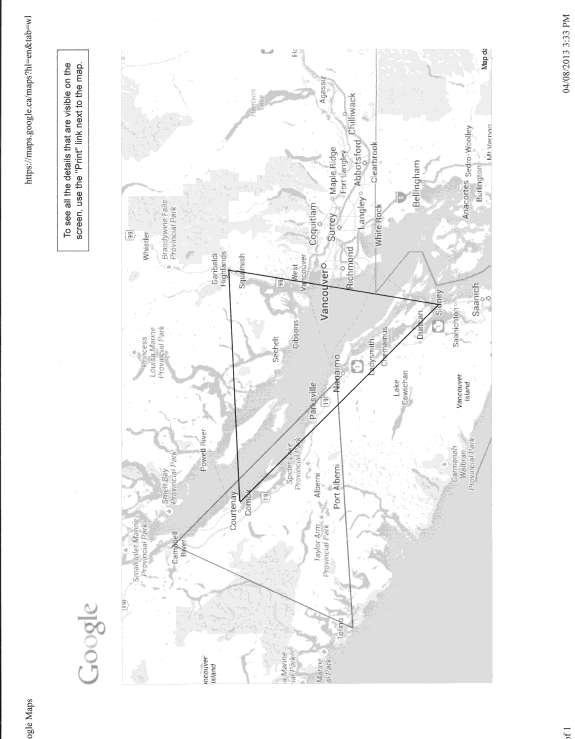
1 This image is from Wolf Reid, described as the foremost expert on Pacific Northwest storms. He is a climatologist and is currently at UBC. He has studied every storm that has hit since The image shows the classic path. These weather bombs hit the west coast of Vancouver Island then gain access to Baynes sound via the Alberni Valley and low lying areas around Cameron Lake. The next page shows the six airports where Wolf examined the data loggers to come up with his conclusions. The page after that is Wolf s conclusions. Pictures that are referred to are on the homepage of this site.
2
3

4
5 Here are some of Wolf s initial comments: 1) The anemometers they used are a good model (R. M. Young). It is interesting that they had problems with the instruments getting stuck. I wonder if they were old units or were installed improperly. They might have needed a calibration check. Thus, all the data may be invalidated. 2) They used a non-standard 6-minute averaging period for wind. Longer averaging periods typically result in a lower wind speed report. In other words, for a given run of wind, a 2-minute average speed will almost certainly be higher than the 6-minute average speed, perhaps by 5-10%. This explains in part the rather low numbers yielded by the study. I wonder why they did not just do a 2-min average to match what is reported at places like Comox? 3) Their 100-year storm magnitude of 16.5 m/s, or 32 knots, does seem low. Accounting for the 6-min vs. 2-min difference (or 6-min vs the 1-min that was employed before the automated 78D anemometers were put into operation), this could be bumped up to around 35 knots, which is still kind of low. From my experience with winds just south of Denman Island, say at Victoria, Vancouver and Abbotsford, stations that have a solid wind record going back over a half-century, computing the 100-year storm results in an estimate of about km/h. Call it 50 knots. The key historic event that approached this magnitude is the Columbus Day Storm (AKA Typhoon Freda). 4) Their choice of Comox over the lighthouse station for regression analysis of the Denman Island wind data seems fine to me. However, and I repeat, it would have made more sense to have recorded 2-minute observations that are comparable to the Comox data. Also, even when factoring in the 6-min averaging period, the Denman numbers do seem low, and again I question the validity of the entire dataset based on their having anemometer problems. And, such a regression analysis, especially for extreme winds, is fraught with peril. There is much randomness to surface wind, mainly due to turbulence near the ground, making an estimate from regression rough at best. This is especially true during an extreme storm, where surface winds can vary considerably over small spatial scales. Based on my analysis, for the Georgia Strait region as a whole, the 12 Mar 2012 windstorm had more punch than the 11 Dec 2006 event. The 2012 extratropical cyclone landed near Solander Island with 962 hpa (mb) central pressure vs. about 980 hpa for the 2006 storm. Also, the 2012 storm landed at near peak intensity, while the 2006 storm had begun to degrade as it slowly drifted ashore. Peak gusts at official (public) Georgia Strait stations were generally higher during the 2012 storm than the 2006 event. That being said, each storm tends to bring its own local effects and certain areas can be slammed while others do not receive as significant a gale. In the case of the 11 Dec 2006 storm, the region around Abbotsford received one of the strongest windstorms in recent memory, with a peak gust far in excess of the 12 Mar 2012 storm
6 (59 kt vs. 34 kt), and also above the infamous Dec 2006 "Hanukkah Eve" tempest, which is one of the reasons why I have chosen to study the event in detail. Another example is the New Year's Day storm in 1997, a fairly strong gale in many areas that brought a focused extreme wind event to the Cathedral Grove area, causing much destruction to the forest. It appears that Denman Island may have received special treatment during the 11 Dec 2006 storm much as did Abbotsford. This shows the level of detail Wolf Reid went into to examine the December 11 th storm of The 0 hour UTC time corresponds to our 4 PM storm that day. The merging of the upper level gradient and the surface gradients created the waterspouts reported off Chrome Island. Just to remind you, Ferries consultants say the wind was 21 knots at this hour.
7 Next is Canada s top weather stories of 2006 from Environment Canada with a report by BC Hydro. The storm of December 11 th lacked the rains of November, but its bluster crippled an already fragile power grid. Wind gusts were 96 km/hr strong, enough to blow over 2 planes at the Victoria airport. Anything not fixed or tied down became airborne. On December 13 th, another powerful storm with hurricane force winds once again walloped the SouthWest. It brought down more trees and power lines some repaired only a day before. Bc Hydro called for reinforcements from Alberta and Yukon to relieve workers who had been putting in 16 hour days non stop for three and a half weeks. August 2013
Weather Forecast Interpretation for Boaters. Cindy Yu Feb 14 th, 2018 Meteorological Service of Canada
 Weather Forecast Interpretation for Boaters Cindy Yu Feb 14 th, 2018 Meteorological Service of Canada Environment Canada s Forecast Regions & Offices PSPC CMC NFSPC PASPC (Edmonton) & CMAC-W PASPC (Winnipeg)
A Climatology of Windstorms in the Western Pacific Northwest,
 A Climatology of Windstorms in the Western Pacific Northwest, 1948-2004 Wolf Read Oregon Climate Service College of Oceanic and Atmospheric Sciences Oregon State University Research Goals Compile data
Storm report: The most damaging storm in BC Hydro s history. Report
 Storm report: The most damaging storm in BC Hydro s history Report January 2019 The windstorm that hit B.C. s South Coast on December 20 resulted in more than 750,000 customers without power and thousands
Inflow and Outflow through the Sea-to-Sky Corridor in February 2010: Lessons Learned from SNOW-V10 *
 Inflow and Outflow through the Sea-to-Sky Corridor in February 2010: Lessons Learned from SNOW-V10 * Ruping Mo National Laboratory for Coastal and Mountain Meteorology, Environment Canada, Vancouver, BC,
WOLF READ 1. Forest and Conservation Sciences, University of British Columbia, Vancouver, BC
 JUNE 2016 R E A D 1 Did Antecedent Hot and Dry Weather Contribute to An Unusual Level of Tree Damage During the 29 August 2015 Windstorm in the Lower Mainland of British Columbia? WOLF READ 1 Forest and
Hurricane Wilma Post Storm Data Acquisition Estimated Peak Wind Analysis and Storm Tide Data. December 27, 2005
 Hurricane Wilma Post Storm Data Acquisition Estimated Peak Wind Analysis and Storm Tide Data December 27, 2005 Hurricane Wilma was the sixth major hurricane of the record-breaking 2005 Atlantic hurricane
Weather forecasts and warnings: Support for Impact based decision making
 Weather forecasts and warnings: Support for Impact based decision making Gerry Murphy, Met Éireann www.met.ie An Era of Change Climate and weather is changing Societal vulnerability is increasing The nature
P9.17 USING SAR WINDS TO EVALUATE SYNOPTIC AND MESOSCALE FEATURES IN FORECAST OPERATIONS
 P9.17 USING SAR WINDS TO EVALUATE SYNOPTIC AND MESOSCALE FEATURES IN FORECAST OPERATIONS Kenneth Chan, Brad Snyder, Laurie Neil Meteorological Service of Canada,, B.C., Canada 1. INTRODUCTION A national
Weather and Climate Basics
 Weather and Climate Basics Laura Boekel Forecaster at Bureau of Meteorology Aims of this presentation To describe what I do as a forecaster at the Bureau of Meteorology To provide an interesting introduction
Weather and Climate Basics
 Aims of this presentation Weather and Climate Basics To describe what I do as a forecaster at the Bureau of Meteorology Laura Boekel Forecaster at Bureau of Meteorology To provide an interesting introduction
Features of the wind fields associated with Typhoon 0418 (Songda) compared with those of Typhoon 9119 (Mireille)
 compared with those of Typhoon 9119 (Mireille)") Features of the wind fields associated with Typhoon 0418 (Songda) compared with those of Typhoon 9119 (Mireille) by Fumiaki Fujibe 1, Naoko Kitabatake 2, Kotaro Bessho 2 and Shunsuke Hoshino 3 ABSTRACT
Features of the wind fields associated with Typhoon 0418 (Songda) compared with those of Typhoon 9119 (Mireille) by Fumiaki Fujibe 1, Naoko Kitabatake 2, Kotaro Bessho 2 and Shunsuke Hoshino 3 ABSTRACT
Colorado CoCoRaHS. Colorado CoCoRaHS. Because Every Drop Counts! November 2014 Volume 2, Issue 11
 U.S. PRECIPITATION (% OF AVERAGE) LOOKING BACK AT OCTOBER 2014 October was a fairly dry month for much of the nation with the exception of the Pacific Northwest, portions of New England and the Tennessee
ARUBA CLIMATOLOGICAL SUMMARY 2014 PRECIPITATION
 ARUBA CLIMATOLOGICAL SUMMARY 2014 PRECIPITATION The total amount of rainfall recorded at Reina Beatrix International Airport for the year 2014 was 309.2 mm. This is 34.4 % below normal ( Figure 1 ). During
The Winter Storm of January 4 and 5, 2018
 The Winter Storm of January 4 and 5, 2018 A winter storm hit the Maritime Provinces on January 4 th and 5 th, 2018. Environment Canada forecasts for the storm predicted high winds from the east, south,
GC Briefing. Weather Sentinel Hurricane Florence. Status at 5 PM EDT (21 UTC) Today (NHC) Discussion. September 13, 2018
 Today (NHC) Discussion. September 13, 2018") GC Briefing September 13, 2018 Weather Sentinel Hurricane Florence Tropical storm conditions have been reported for areas of North Carolina and will continue to spread inland to the west and south. Hurricane
GC Briefing September 13, 2018 Weather Sentinel Hurricane Florence Tropical storm conditions have been reported for areas of North Carolina and will continue to spread inland to the west and south. Hurricane
Go With the Flow From High to Low Investigating Isobars
 Go With the Flow From High to Low Investigating Isobars Science 10 Mrs. Purba Air Masses The air over a warm surface can be heated, causing it to rise above more dense air. The result is the formation
Reven ue Req u i remen t Ap pl icat ion 2004/05 and 2005/06. BC hydro m W. Volume 2. Appendix L. System Performance Indicators
 Reven ue Req u i remen t Ap pl icat ion 00/0 and 00/0 BC hydro m W Volume Appendix L. System Performance Indicators BChydro m ui Table of Contents LIST OF FIGURES... I LIST OF TABLES... I LIST OF SCHEDULES...
Hurricane Irma Page 1 HURRTRAK RM/Pro 2017 Summary Report for Tampa, FL 09/10/ EDT, Adv. # 46
 Hurricane Irma Page 1 Description of impact to Tampa, FL, Tampa, FL, is expected to receive a major impact from Hurricane Irma. The forecast maximum wind for this location has increased since the last
The Impact of Climate Change on the Intensity and Frequency of Windstorms in Canada
 The Impact of Climate Change on the Intensity and Frequency of Windstorms in Canada Lou Ranahan, Meteorologist March 27, 219 mase889/ Twitter 1 P a g e Table of Contents List of Figures... 2 List of Tables...
ARUBA CLIMATOLOGICAL SUMMARY 2017 PRECIPITATION
 ARUBA CLIMATOLOGICAL SUMMARY 2017 PRECIPITATION The total amount of rainfall recorded at Reina Beatrix International Airport for the year 2017 was 391.0 mm. This is 17.1 % below normal ( Figure 1 ). During
Module 9 Weather Systems
 Module 9 Weather Systems In this module the theory of atmospheric dynamics is applied to different weather phenomena. The first section deals with extratropical cyclones, low and high pressure areas of
TROPICAL CYCLONE TC 03A FOR THE PERIOD 3 RD JUNE TO 10 TH JUNE, 1998
 TROPICAL CYCLONE TC 03A FOR THE PERIOD 3 RD JUNE TO 10 TH JUNE, 1998 Hazrat Mir, Abdul Rashid, Waqarul Wheed Khan. Introduction: This report gives the review of cyclonic storm formed over the East Arabian
2A.5 A Climatology of Catastrophic Flooding in Texas From Tropical Cyclones Derek Ortt and Cameron Self StormGeo Inc, Houston, Texas
 2A.5 A Climatology of Catastrophic Flooding in Texas From Tropical Cyclones Derek Ortt and Cameron Self StormGeo Inc, Houston, Texas 1. INTRODUCTION In August 2017, Hurricane Harvey produced catastrophic
Hurricane Florence: Rain this heavy comes along once every 1,000 years
 Hurricane Florence: Rain this heavy comes along once every 1,000 years By Associated Press, adapted by Newsela staff on 09.17.18 Word Count 786 Level 810L Image 1. This satellite image provided by the
SIGNIFICANT EVENTS Severe Storms November 1994 January 1996 August 1998 and May 2000 March 2002 May 2002 Champaign County
 SIGNIFICANT EVENTS Severe Storms November 1994 On Nov. 1, 1994, high winds gusted over 60 mph at times across the northwest third of Ohio. The highest measured wind gust was 63 mph at Columbus Grove (Putnam).
Monthly Long Range Weather Commentary Issued: SEPTEMBER 19, 2015 Steven A. Root, CCM, Chief Analytics Officer, Sr. VP, sales
 Monthly Long Range Weather Commentary Issued: SEPTEMBER 19, 2015 Steven A. Root, CCM, Chief Analytics Officer, Sr. VP, sales sroot@weatherbank.com AUGUST 2015 Climate Highlights The Month in Review The
Hurricane Irma Page 1 HURRTRAK RM/Pro 2017 Summary Report for Tampa, FL 09/09/ EDT, Adv. # 43
 Hurricane Irma Page 1 Description of impact to Tampa, FL, Tampa, FL, is expected to receive a major impact from Hurricane Irma. The forecast maximum wind for this location has decreased since the last
Ch. 11: Hurricanes. Be able to. Define what hurricane is. Identify the life and death of a hurricane. Identify the ways we track hurricanes.
 Ch. 11: Hurricanes Be able to Define what hurricane is. Identify the life and death of a hurricane. Identify the ways we track hurricanes. What are Hurricanes? Smaller than mid-latitude cyclones. Don t
WIND DATA REPORT FOR THE YAKUTAT JULY 2004 APRIL 2005
 WIND DATA REPORT FOR THE YAKUTAT JULY 2004 APRIL 2005 Prepared on July 12, 2005 For Bob Lynette 212 Jamestown Beach Lane Sequim WA 98382 By John Wade Wind Consultant LLC 2575 NE 32 nd Ave Portland OR 97212
Adjusting Peak 5-Second Wind to Better Fit with Past Instant Gust Measures. compiled by Wolf Read. Introduction
 Adjusting Peak 5-Second Wind to Better Fit with Past Instant Gust Measures compiled by Wolf Read Introduction By the end of 1996, Automated Surface Observing System (ASOS) stations had been commissioned
CASE STUDY: Tropical Cyclone Monica, April 2006
 CASE STUDY: Tropical Cyclone Monica, April 2006 By Mr Jeff Callaghan Retired Senior Severe Weather Forecaster, Bureau of Meteorology, Brisbane The track of tropical cyclone Monica (Figure 1) took it from
Weather Practice Test
 Name: Weather Practice Test 1. The diagram below shows weather instruments A and B. Which table correctly indicates the name of the weather instrument and the weather variable that it measures? A) B) C)
Chapter 24 Tropical Cyclones
 Chapter 24 Tropical Cyclones Tropical Weather Systems Tropical disturbance a cluster of thunderstorms about 250 to 600 km in diameter, originating in the tropics or sub-tropics Tropical depression a cluster
Nerushev A.F., Barkhatov A.E. Research and Production Association "Typhoon" 4 Pobedy Street, , Obninsk, Kaluga Region, Russia.
 DETERMINATION OF ATMOSPHERIC CHARACTERISTICS IN THE ZONE OF ACTION OF EXTRA-TROPICAL CYCLONE XYNTHIA (FEBRUARY 2010) INFERRED FROM SATELLITE MEASUREMENT DATA Nerushev A.F., Barkhatov A.E. Research and
Development of Tropical Storm Falcon (Meari) over the Philippines
 over the Philippines") Development of Tropical Storm Falcon (Meari) over the Philippines June 20-27, 2011 At the end of June, 2011, the Philippines were struck again by Tropical storm Falcon (Meari). After gaining strength over
Development of Tropical Storm Falcon (Meari) over the Philippines June 20-27, 2011 At the end of June, 2011, the Philippines were struck again by Tropical storm Falcon (Meari). After gaining strength over
April Forecast Update for Atlantic Hurricane Activity in 2016
 April Forecast Update for Atlantic Hurricane Activity in 2016 Issued: 5 th April 2016 by Professor Mark Saunders and Dr Adam Lea Dept. of Space and Climate Physics, UCL (University College London), UK
Tropical Storms & Hurricanes Part 1. August 1992
 Lecture #16 (April 5, 2010, Monday) Tropical Storms & Hurricanes Part 1 August 1992 Tracks of rain accumulation & clouds from Hurricane Rita September 2005 Tropical Cyclones Around the Globe Why none here?
Hurricanes form over warm ocean water.
 KEY CONCEPT Low-pressure systems can become storms. BEFORE, you learned Moving air masses cause changes in weather A low-pressure system brings stormy weather NOW, you will learn How hurricanes develop
Unit 5 Part 2 Test PPT
 Unit 5 Part 2 Test PPT Standard 1: Air Masses Air Mass An air mass is an immense body of air that is characterized by similar temperatures and amounts of moisture at any given altitude When an air mass
Chapter 5: Weather Systems
 Chapter 5: Weather Systems Norwegian Cyclone Model: Polar Front Theory Mid Latitude Cyclones: extratropical cyclones, Nor easters Hurricanes Storm Surge Mid-latitude Cyclone: -primary weather producers
Storm Summary for Hurricane Jose
 Storm Summary for Hurricane Jose Tuesday, September 19, 2017 at 11 AM EDT (Output from Hurrevac, based on National Hurricane Center Forecast Advisory #57) Jose is currently a Category 1 hurricane on the
Analysis of Fall Transition Season (Sept-Early Dec) Why has the weather been so violent?
 Why has the weather been so violent?") WEATHER TOPICS Analysis of Fall Transition Season (Sept-Early Dec) 2009 Why has the weather been so violent? As can be seen by the following forecast map, the Fall Transition and early Winter Season of
WEATHER TOPICS Analysis of Fall Transition Season (Sept-Early Dec) 2009 Why has the weather been so violent? As can be seen by the following forecast map, the Fall Transition and early Winter Season of
1 What Is Climate? TAKE A LOOK 2. Explain Why do areas near the equator tend to have high temperatures?
 CHAPTER 17 1 What Is Climate? SECTION Climate BEFORE YOU READ After you read this section, you should be able to answer these questions: What is climate? What factors affect climate? How do climates differ
The benefits and developments in ensemble wind forecasting
 The benefits and developments in ensemble wind forecasting Erik Andersson Slide 1 ECMWF European Centre for Medium-Range Weather Forecasts Slide 1 ECMWF s global forecasting system High resolution forecast
Synoptic Meteorology II: Frontogenesis Examples Figure 1
 Synoptic Meteorology II: Frontogenesis Examples The below images, taken from the 1200 UTC 17 January 2019 GFS forecast run, provide examples of the contributions of deformation and divergence to frontogenesis.
Goal: Understand the classification and basic structure of tropical cyclones
 Tropical cyclone background Saffir-Simpson scale Overview of structure Hurricane Isidore, 09/19/02 from a NOAA Orion P-3 Hurricane Hunter Goal: Understand the classification and basic structure of tropical
Arizona Climate Summary February 2012
 Arizona Climate Summary February 2012 Summary of conditions for January 2012 January 2012 Temperature and Precipitation Summary January 1 st 20 th : The New Year has started on a very dry note. The La
Hurricane Recipe. Hurricanes
 Hurricanes A hurricane is a powerful, rotating storm that forms over warm oceans near the Equator. Hurricanes have strong, rotating winds (at least 74 miles per hour), a huge amount of rain, low air pressure,
3 Severe Weather. Critical Thinking
 CHAPTER 2 3 Severe Weather SECTION Understanding Weather BEFORE YOU READ After you read this section, you should be able to answer these questions: What are some types of severe weather? How can you stay
Champaign-Urbana 1999 Annual Weather Summary
 Champaign-Urbana 1999 Annual Weather Summary ILLINOIS STATE WATER SURVEY 2204 Griffith Dr. Champaign, IL 61820 wxobsrvr@sws.uiuc.edu Maria Peters, Weather Observer A major snowstorm kicked off the new
Hurricanes. Hurricanes are large, tropical storm systems that form and develop over the warm waters near the equator.
 Hurricanes Hurricanes are large, tropical storm systems that form and develop over the warm waters near the equator. They are responsible for weather that can devastate entire communities: Heavy rain --
UPDATE OF REGIONAL WEATHER AND SMOKE HAZE (December 2017)
") UPDATE OF REGIONAL WEATHER AND SMOKE HAZE (December 2017) 1. Review of Regional Weather Conditions for November 2017 1.1 In November 2017, Southeast Asia experienced inter-monsoon conditions in the first
UPDATE OF REGIONAL WEATHER AND SMOKE HAZE (December 2017) 1. Review of Regional Weather Conditions for November 2017 1.1 In November 2017, Southeast Asia experienced inter-monsoon conditions in the first
WEATHER FORECASTING Acquisition of Weather Information WFO Regions Weather Forecasting Tools Weather Forecasting Tools Weather Forecasting Methods
 1 2 3 4 5 6 7 8 WEATHER FORECASTING Chapter 13 Acquisition of Weather Information 10,000 land-based stations, hundreds of ships and buoys; four times a day, airports hourly Upper level: radiosonde, aircraft,
Storm Summary for Hurricane Joaquin
 Storm Summary for Hurricane Joaquin Wednesday, September 30, 2015 at 5 PM EDT (Output from Hurrevac, based on National Hurricane Center Forecast Advisory #12) Joaquin is currently a Category 1 hurricane
CASE STUDY OF THE NOVEMBER WINDSTORM IN SOUTH CENTRAL COLORADO
 32 CASE STUDY OF THE 12-13 NOVEMBER WINDSTORM IN SOUTH CENTRAL COLORADO Paul Wolyn * NOAA/NWS Pueblo, CO 1. INTRODUCTION During the evening and early morning of 12-13 November 2011, a damaging downslope
Boston Extremes. Lodovica Illari - EAPS mit.edu. 8/30/2011 Hurricane Irene slams East Coast. 8/23/2011 Earthquake shakes Boston area
 Boston Extremes 8/23/2011 Earthquake shakes Boston area 8/30/2011 Hurricane Irene slams East Coast 10/30/2011 Bizarre Blizzard hits Boston area Lodovica Illari - EAPS illari@ mit.edu Not Christmas but
A Tropical Cyclone with a Very Large Eye
 JANUARY 1999 PICTURES OF THE MONTH 137 A Tropical Cyclone with a Very Large Eye MARK A. LANDER University of Guam, Mangilao, Guam 9 September 1997 and 2 March 1998 1. Introduction The well-defined eye
Guided Notes Weather. Part 2: Meteorology Air Masses Fronts Weather Maps Storms Storm Preparation
 Guided Notes Weather Part 2: Meteorology Air Masses Fronts Weather Maps Storms Storm Preparation The map below shows North America and its surrounding bodies of water. Country borders are shown. On the
Tropical-Extratropical Transition
 Tropical-Extratropical Transition Extratropical Transition A significant number of tropical cyclones move into the midlatitudes and transform into extratropical cyclones. This process is generally referred
Thunderstorms. Ordinary Cell Thunderstorms. Ordinary Cell Thunderstorms. Ordinary Cell Thunderstorms 5/2/11
 A storm containing lightning and thunder; convective storms Chapter 14 Severe thunderstorms: At least one: large hail wind gusts greater than or equal to 50 kt Tornado 1 2 Ordinary Cell Ordinary Cell AKA
QA/QC of Aleutian Buoy and Airport Observation Data
 QA/QC of Aleutian Buoy and Airport Observation Data Background Document prepared by Uwe Gramann, P.Met. Mountain Weather Services Smithers, BC October 212 Airport Data Comments: Dataset includes hourly
Predicting tsunami waves and currents on the West Coast of Canada: A case study for Ucluelet, BC
 Predicting tsunami waves and currents on the West Coast of Canada: A case study for Ucluelet, BC Josef Cherniawsky, Kelin Wang and Roy Walters Institute of Ocean Sciences, Fisheries & Oceans Canada Pacific
CASE STUDY: Severe Thunder Storms and Bucca Tornado, 29 th November 1992
 CASE STUDY: Severe Thunder Storms and Bucca Tornado, 29 th November 1992 By Mr Jeff Callaghan Retired Senior Severe Weather Forecaster, Bureau of Meteorology, Brisbane This was a notable severe thunderstorm
2015: A YEAR IN REVIEW F.S. ANSLOW
 2015: A YEAR IN REVIEW F.S. ANSLOW 1 INTRODUCTION Recently, three of the major centres for global climate monitoring determined with high confidence that 2015 was the warmest year on record, globally.
Revisiting predictability of the strongest storms that have hit France over the past 32 years.
 Revisiting predictability of the strongest storms that have hit France over the past 32 years. Marie Boisserie L. Descamps, P. Arbogast GMAP/RECYF 20 August 2014 Introduction Improving early detection
The Impact of 2007 Atlantic Hurricane Season on Dominica
 The Impact of 2007 Atlantic Hurricane Season on Dominica DOMINICA November 2007 Main Activities Freak Twister on June 21st 2007. Hurricane Dean on August 16th to 17th 2007 Active Tropical Wave on September
Champaign-Urbana 2000 Annual Weather Summary
 Champaign-Urbana 2000 Annual Weather Summary ILLINOIS STATE WATER SURVEY 2204 Griffith Dr. Champaign, IL 61820 wxobsrvr@sws.uiuc.edu Maria Peters, Weather Observer January: January started on a mild note,
Motivation. Lost at Sea: Hurricane Force Wind Fields and the North Pacific Ocean Environment
 Lost at Sea: Hurricane Force Wind Fields and the North Pacific Ocean Environment Lost at Sea: Hurricane Force Wind Fields and the North Pacific Ocean Environment Unidata Policy Committee Meeting 5/15/2012
Monthly Long Range Weather Commentary Issued: February 15, 2015 Steven A. Root, CCM, President/CEO
 Monthly Long Range Weather Commentary Issued: February 15, 2015 Steven A. Root, CCM, President/CEO sroot@weatherbank.com JANUARY 2015 Climate Highlights The Month in Review During January, the average
Collision of a Pineapple Express with an Arctic Outbreak over Complex Terrains of British Columbia, Canada Forecast Challenges and Lessons Learned
 1 10B.2 Collision of a Pineapple Express with an Arctic Outbreak over Complex Terrains of British Columbia, Canada Forecast Challenges and Lessons Learned Ruping Mo *, Quanzhen Geng, Mindy Brugman, Greg
Predicting Weather Conditions. Do you have a career as a meteorologist?
 Predicting Weather Conditions Do you have a career as a meteorologist? It is essential for students for know 1. Weather conditions and patterns can be based on weather data collected from various sources.
20.1 Air Masses. Weather Patterns and Severe Storms. Four Types of Source Regions. Weather in North America Fronts
 20.1 Air Masses Weather Patterns and Severe Storms Chapter 20 A huge body of air that has a uniform temperature and humidity. They move slowly, and take on the properties of their source regions. Four
Government of Sultanate of Oman Public Authority of Civil Aviation Directorate General of Meteorology. National Report To
 Government of Sultanate of Oman Public Authority of Civil Aviation Directorate General of Meteorology National Report To Panel on Tropical Cyclones in the Bay of Bengal And Arabian Sea 43rd Session, India
Table of Contents. Annual Report
 Blackout Tracker Table of Contents Introduction... 3 Productivity and Monetary Loss... 3 Significant Outages in Canada... 4 Provinces ranked by Outage... 5 What You Can Do to Protect Your Business... 5
WYANDOTTE MUNICIPAL SERVICES COMMUNITY WIND ENERGY PROJECT WIND RESOUCE SUMMARY
 WYANDOTTE MUNICIPAL SERVICES COMMUNITY WIND ENERGY PROJECT WIND RESOUCE SUMMARY MONTHLY REPORT October 15, 2007 Black & Veatch Project: 144374 Prepared by: Black & Veatch Corporation 6300 S. Syracuse Way
The Use of GPS Radio Occultation Data for Tropical Cyclone Prediction. Bill Kuo and Hui Liu UCAR
 The Use of GPS Radio Occultation Data for Tropical Cyclone Prediction Bill Kuo and Hui Liu UCAR Current capability of the National Hurricane Center Good track forecast improvements. Errors cut in half
Monthly Long Range Weather Commentary Issued: SEPTEMBER 19, 2016 Steven A. Root, CCM, Chief Analytics Officer, Sr. VP,
 Monthly Long Range Weather Commentary Issued: SEPTEMBER 19, 2016 Steven A. Root, CCM, Chief Analytics Officer, Sr. VP, sroot@weatherbank.com SEPTEMBER 2016 Climate Highlights The Month in Review The contiguous
August Forecast Update for Atlantic Hurricane Activity in 2015
 August Forecast Update for Atlantic Hurricane Activity in 2015 Issued: 5 th August 2015 by Professor Mark Saunders and Dr Adam Lea Dept. of Space and Climate Physics, UCL (University College London), UK
OPALCO Outage Analysis. December 2017 Board Meeting
 OPALCO Outage Analysis December 217 Board Meeting What causes power outages in the islands? Wind Rain Major outages happen most often during wind storms - when winds are blowing above 3 miles per hour.
EOSC114 spring summary of PRS responses
 EOSC114 Clicker questions spring 2008 1 of 20 EOSC114 spring 2008 - summary of PRS responses Introduction This page contains all questions generated in Spring term 2008 for use as in-class clicker questions.
Satellites, Weather and Climate Module??: Polar Vortex
 Satellites, Weather and Climate Module??: Polar Vortex SWAC Jan 2014 AKA Circumpolar Vortex Science or Hype? Will there be one this year? Today s objectives Pre and Post exams What is the Polar Vortex
Unmanned Aircraft Hurricane Reconnaissance. Pat Fitzpatrick GeoSystems Research Institute Mississippi State University Stennis Space Center branch
 Unmanned Aircraft Hurricane Reconnaissance Pat Fitzpatrick GeoSystems Research Institute Mississippi State University Stennis Space Center branch Outline Motivation Unmanned Aircraft Systems (UAS) [also
ESCI 1010 Lab 7 Hurricanes (AKA: Typhoons, Cyclones)
") ESCI 1010 Lab 7 Hurricanes (AKA: Typhoons, Cyclones) Before Lab: Review pages 328-361 in your Weather and Climate textbook. Please pay special attention to the sections entitled: Hurricanes around the
ESCI 1010 Lab 7 Hurricanes (AKA: Typhoons, Cyclones) Before Lab: Review pages 328-361 in your Weather and Climate textbook. Please pay special attention to the sections entitled: Hurricanes around the
Tropical Cyclone Forecasting Applications of the GOES WMSI
 1. Introduction Tropical Cyclone Forecasting Applications of the GOES WMSI Kenneth L. Pryor Center for Satellite Applications and Research (NOAA/NESDIS) Camp Springs, MD The Geostationary Operational Environmental
 Page 1 of 5 Home research global climate enso effects Research Effects of El Niño on world weather Precipitation Temperature Tropical Cyclones El Niño affects the weather in large parts of the world. The
What a Hurricane Needs to Develop
 Weather Weather is the current atmospheric conditions, such as air temperature, wind speed, wind direction, cloud cover, precipitation, relative humidity, air pressure, etc. 8.10B: global patterns of atmospheric
ovember 2008 Antigua and Barbuda Meteorological Service
 ovember 2008 Antigua and Barbuda Meteorological Service The Atlantic Hurricane Season Summary 2008 Special Focus on Antigua and Barbuda The Season in Brief Sixteen (16) named storms formed in the Atlantic
April Forecast Update for Atlantic Hurricane Activity in 2018
 April Forecast Update for Atlantic Hurricane Activity in 2018 Issued: 5 th April 2018 by Professor Mark Saunders and Dr Adam Lea Dept. of Space and Climate Physics, UCL (University College London), UK
Module 11: Meteorology Topic 6 Content: Severe Weather Notes
 Severe weather can pose a risk to you and your property. Meteorologists monitor extreme weather to inform the public about dangerous atmospheric conditions. Thunderstorms, hurricanes, and tornadoes are
Significant Rainfall and Peak Sustained Wind Estimates For Downtown San Francisco
 Significant Rainfall and Peak Sustained Wind Estimates For Downtown San Francisco Report Prepared by John P. Monteverdi, PhD, CCM July 30, 1998 Mayacamas Weather Consultants 1. Impact of Location The location
Arizona Climate Summary May 2012
 Arizona Climate Summary May 2012 Summary of conditions for April 2012 April 2012 Temperature and Precipitation Summary April 1 st 16 th : Although April began with another low pressure system sweeping
Ocean in Motion 7: El Nino and Hurricanes!
 Ocean in Motion 7: El Nino and Hurricanes! A. Overview 1. Ocean in Motion -- El Nino and hurricanes We will look at the ocean-atmosphere interactions that cause El Nino and hurricanes. Using vocabulary
How strong does wind have to be to topple a garbage can?
 How strong does wind have to be to topple a garbage can? Imagine winds powerful enough to pick up a truck and toss it the length of a football field. Winds of this extreme sometimes happen in a tornado.
The hydrologic service area (HSA) for this office covers Central Kentucky and South Central Indiana.
 for this office covers Central Kentucky and South Central Indiana.") January 2012 February 13, 2012 An X inside this box indicates that no flooding occurred within this hydrologic service area. January 2012 continued the string of wet months this winter. Rainfall was generally
January 2012 February 13, 2012 An X inside this box indicates that no flooding occurred within this hydrologic service area. January 2012 continued the string of wet months this winter. Rainfall was generally
A HIGH-RESOLUTION RAPIDLY-UPDATED METEOROLOGICAL DATA ANALYSIS SYSTEM FOR AVIATION APPLICATIONS
 A HIGH-RESOLUTION RAPIDLY-UPDATED METEOROLOGICAL DATA ANALYSIS SYSTEM FOR AVIATION APPLICATIONS C. S. Lau *, J. T. K. Wan and M. C. Chu Department of Physics, The Chinese University of Hong Kong, Hong
Arizona Climate Summary November 2018 Summary of conditions for October 2018
 Arizona Climate Summary November 2018 Summary of conditions for October 2018 October 2018 Temperature and Precipitation Summary October 1 st 15 th : The 2018 water year ending September 30 th was exceptionally
Custom Weather Forecast
 1 of 23 Custom Weather Forecast 2018 Chicago Yacht Club s Race To Mackinac- Cruising Division Disclaimer: The user assumes all risk related to the use of this Custom Weather Forecast. The crew of the participating
Application of microwave radiometer and wind profiler data in the estimation of wind gust associated with intense convective weather
 Application of microwave radiometer and wind profiler data in the estimation of wind gust associated with intense convective weather P W Chan 1 and K H Wong 2 1 Hong Kong Observatory, 134A Nathan Road,
Guided Reading Chapter 18: Weather Patterns
 Name Number Date Guided Reading Chapter 18: Weather Patterns 18-1: Air Masses and Fronts 1. What is an air mass? 2. Scientists classify air masses according to and 3. Is the following sentence true or
Chapter 3: Weather Fronts & Storms
 Chapter 3: Weather Fronts & Storms An AIR MASS is a large body of air that has similar characteristics (temperature, humidity) throughout. Air masses can be massively large. Air masses are classified by