B KMD 550/850 Multi-Function Display Quick Reference For Software Version 01/14 or Later
|
|
|
- Nelson Simpson
- 5 years ago
- Views:
Transcription
 9. Power Labels 10. Soft Labels 11. Joystick 12. Power Keys 13.")
1 F N B KMD 550/850 Multi-Function Display Quick Reference For Software Version 01/14 or Later Brightness Control 2. Data Card 3. Display 4. Available Functions Legend 5. On/Off Control 6. Selected Function Indicators 7. Function Select Keys FUNCTION SELECT KEYS 8. Control Knobs (Inner and Outer Knob) 9. Power Labels 10. Soft Labels 11. Joystick 12. Power Keys 13. Fault Indicator 8 Topo On Map WX Radar* TAS/TCAS EGPWS Setup Pages Topo Off Map Stormscope External NTSC Video FIS Graphical Products FIS Textual Products 1

2 AVAILABLE FUNCTIONS ICONS 2
3 INTERACTION OF CONTROLS 3

4 MAP FUNCTION Display Range - RNG:####nm 2 Current Track - TRK:### 3 Current Ground Speed - GS:###kt 4 Distance to Pointer - PDIS: ###.#nm 5 Position Readout - Current aircraft position 6 Control Knob Label - Indicates Control Knob is active for data entry 7 Bearing to Pointer - PBRG: ### 8 MORE INFO Soft Label 9 Range Rings - Outer ring radius is selected range, inner ring radius is one half the selected range 10 RESET STICK Soft Label 11 Joystick Label 12 Lightning Overlay 13 GPS Flight Plan Overlay - Current GPS flight plan 14 Aircraft Symbol - Indicates present position. Stylized airplane when heading input is present, a plus symbol with no heading. 15 Distance to Waypoint - DIS:###.#nm 16 North Pointer 17 Available Functions - Displays icons representing data available (black) and displayed (color)

5 MAP ICONS 5
6 OVERLAYING DATA OVERLAY TYPE DISPLAY FLIGHT PLAN STORMSCOPE TRAFFIC FIS METAR MAP - TOPO ON Yes Yes 1 Yes 2 Yes MAP - TOPO OFF Yes Yes 1 Yes 2 Yes WX - Weather Radar Yes 1 Yes Yes 3 No WX - Stormscope Yes 1 N/A No No WX - NEXRAD Yes Yes 1 No No WX - Graphical METARs Yes No No N/A WX - Graphical AIRMETs Yes Yes 1 No No WX - Graphical SIGMETs Yes Yes 1 No No WX - Graphical Conv SIGMETs Yes Yes 1 No No WX - Graphical Wx Watches Yes Yes 1 No No TERR Yes Yes 1 Yes 2 No TRFC Yes 1 No N/A No 1 Requires remote heading input 2 TCAS/TAS requires remote heading input 3 TIS requires remote heading input 6
 or down (D). 5 Joystick Function Label - Moving the joystick up and down adjusts the radar tilt.")
 9 Available Functions - Displays icons")
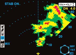
7 WEATHER RADAR Aircraft Symbol 2 Knob Function Label - Rotating the outer knob selects between Standby (SBY), Test (TST), ON and SET modes. 3 Display Range Indications 4 Tilt Angle - XX.X Degrees up (U) or down (D). 5 Joystick Function Label - Moving the joystick up and down adjusts the radar tilt. Moving the joystick left and right adjusts the location of the yellow track line. 6 Stabilization Indication 7 Track Angle 8 WX Radar Mode Indication - TEST, WX, WX/ARL (Auto Range Limiting or MAP (Ground Mapping Mode) 9 Available Functions - Displays icons representing data available (black) and displayed (color) 10 Fault Message Window - See Error and Fault Messages AVAILABLE WEATHER RADAR FUNCTION ICONS 7


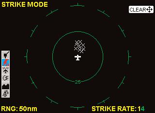
8 STORMSCOPE AVAILABLE STORMSCOPE FUNCTION ICONS LIGHTNING ICONS WX-500 WX-1000E 8
9 FLIGHT INFORMATION SERVICES DATALINK WEATHER 9
10 SUBSCRIBING TO FIS SERVICES Get Display ID from unit in airplane Go to Bendixking.com or call to subscribe to FIS Services Enter Display ID during registration (This is only required first time you subscribe) Select the desired services Receive Subscription Code(s) and print them out Take printed out code(s) to the airplane and enter code(s) on the FIS Subscription Status Page Update Data Card if needed. Update at least once per year to ensure continued FIS Services Enjoy flying with FIS Services! SETTING UP A FIS SUBSCRIPTION 10

11 Note the FIS Display ID and contact Wingman Services at or call This ID is used to obtain the Subscription Code. After obtaining the Subscription Code press the ADD SUBSCR Key. 11
12 Use the inner knob to enter characters and the outer knob to move to the next field. After the last character is entered, press the ENTER Key. After the subscription is accepted it will be displayed. 12


13 CHECKING FIS SUBSCRIPTIONS NOTE: Only the validity period for subscriptions is shown on the display. To determine which products are available with each subscription, access the account on Wingman Services at 13
 and displayed (color). 3 North Pointer - Indicates north.")

14 AVAILABLE FIS FUNCTION ICONS NEXRAD PAGE Range Scale - Indicated selected range. 2 Available Functions - Displays icons representing data available (black) and displayed (color). 3 North Pointer - Indicates north. 4 Range Rings - Outer ring radius is selected range and inner ring radius is one half the selected range. 5 MODE - Indicates the weather product being displayed. 6 Control Knob Icon - Displayed when the Control Knobs are available for cycling through the graphical weather products. 7 Joystick Label - Indicates joystick is active and can be used to pan map. 8 No Coverage Area - Crosshatch pattern indicates area of no coverage. 9 Precipitation - NEXRAD precipitation returns. 10 Aircraft Symbol - Indicates present aircraft position and heading (if available) or track. 11 Age of Data - Age of the data based on current time minus NEXRAD issue time. 12 Age Status Bar - Indicates percentage of age versus elapsed time before expiration. The bar will be green the first 50% then turn yellow. 14
 and displayed (color).")

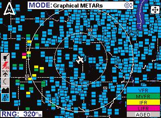
15 NEXRAD INTENSITY Precipitation intensity is depicted using colors as follows: Green Light Level dbz Yellow Moderate Level dbz Red Heavy Level dbz Magenta Intense Level dbz GRAPHICAL METAR PAGE Range Scale - Indicated selected range. 2 Available Functions - Displays icons representing data available (black) and displayed (color). 3 Graphical METAR Icon - Ceiling indicated in top box, visibility in the bottom box and ICAO identifier of issuing airport. Note that ICAO identifiers are not displayed on all range settings. 4 North Pointer - Indicates north. 5 MODE - Indicates the weather product being displayed. 6 Control Knob Icon - Displayed when the Control Knobs are available for cycling through the graphical weather products. 7 Joystick Label - Indicates joystick is active and can be used to pan map. 8 Range Rings - Outer ring radius is selected range and inner ring radius is one half the selected range. 9 Aircraft Symbol - Indicates present aircraft position and heading (if available) or track. 10 METAR Color Key - Colors indicating flight rules pertaining to ceiling and visibility. GRAPHICAL METAR COLOR CODING 15
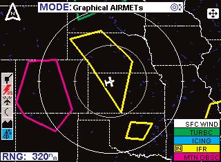
16 GRAPHICAL AIRMET PAGE Range Scale - Indicated selected range. 2 Available Functions - Displays icons representing data available (black) and displayed (color). 3 North Pointer - Indicates north. 4 MODE - Indicates the weather product being displayed. 5 Control Knob Icon - Displayed when the Control Knobs are available for cycling through the graphical weather products. 6 Joystick Label - Indicates joystick is active and can be used to pan map. 7 Range Rings - Outer ring radius is selected range and inner ring radius is one half the selected range. 8 Aircraft Symbol - Indicates present aircraft position and heading (if available) or track. 9 AIRMET Boundary - Color coded line indicating the boundaries of an AIRMET. 10 AIRMET Color Key - Colors indicating AIRMET type. 11 IN - Indicates the current aircraft position is IN an IFR AIRMET
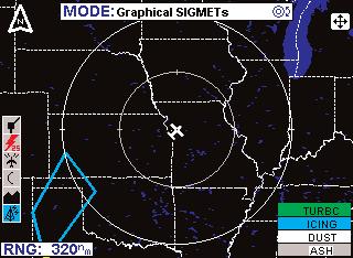
17 GRAPHICAL SIGMET PAGE Range Scale - Indicated selected range. 2 Available Functions - Displays icons representing data available (black) and displayed (color). 3 North Pointer - Indicates north. 4 MODE - Indicates the weather product being displayed. 5 Control Knob Icon - Displayed when the Control Knobs are available for cycling through the graphical weather products. 6 Joystick Label - Indicates joystick is active and can be used to pan map. 7 Range Rings - Outer ring radius is selected range and inner ring radius is one half the selected range. 8 Aircraft Symbol - Indicates present aircraft position and heading (if available) or track. 9 SIGMET Boundary - Color coded line indicating the boundaries of a SIGMET. 10 SIGMET Color Key - Colors indicating SIGMET type. 17
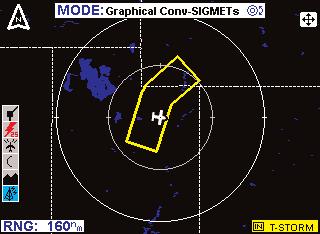
18 GRAPHICAL CONVECTIVE SIGMET PAGE Range Scale - Indicated selected range. 2 Available Functions - Displays icons representing data available (black) and displayed (color). 3 North Pointer - Indicates north. 4 MODE - Indicates the weather product being displayed. 5 Control Knob Icon - Displayed when the Control Knobs are available for cycling through the graphical weather products. 6 Joystick Label - Indicates joystick is active and can be used to pan map. 7 Range Rings - Outer ring radius is selected range and inner ring radius is one half the selected range. 8 Aircraft Symbol - Indicates present aircraft position and heading (if available) or track. 9 Convective SIGMET Boundary - Color coded line indicating the boundaries of a Convective SIGMET. 10 IN - Indicates the current aircraft position is IN a thunderstorm Convective SIGMET. 11 Convective SIGMET Color Key - Colors indicating Convective SIGMET type
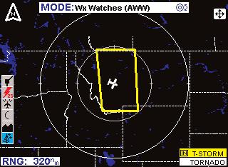
19 GRAPHICAL WEATHER WATCHES PAGE Range Scale - Indicated selected range. 2 Available Functions - Displays icons representing data available (black) and displayed (color). 3 North Pointer - Indicates north. 4 MODE - Indicates the weather product being displayed. 5 Control Knob Icon - Displayed when the Control Knobs are available for cycling through the graphical weather products. 6 Joystick Label - Indicates joystick is active and can be used to pan map. 7 Range Rings - Outer ring radius is selected range and inner ring radius is one half the selected range. 8 Aircraft Symbol - Indicates present aircraft position and heading (if available) or track. 9 Weather Watch Boundary - Color coded line indicating the boundaries of an Alert Weather Watch. 10 IN - Indicates the current aircraft position is IN a severe thunderstorm watch area. 11 Weather Watch Color Key - Colors indicating Alert Weather Watch type

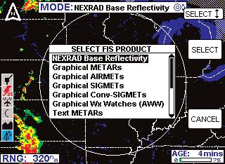
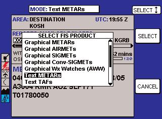
20 FIS TEXT PAGE Text Field - The encoded weather report is displayed in this field. 2 Available Functions - Displays icons representing data available (black) and displayed (color). 3 Selected Report Info - Displays name, city and state of selected report. 4 Selected Area Identifier - Displays the identifier of the area selection. 5 Area Selection - Pressing the CHANGE AREA soft key cycles between Destination, Flightplan WPT, Nearest and User Defined. 6 Mode - Pressing the MODE key will display the SELECT FIS PRODUCT Menu. 7 UTC - Current UTC time. 8 Report - Each horizontal movement of the joystick will move the cursor over the next report in the AVAILABLE REPORTS field. 9 Available Reports - Shows available reports based on the selection in the AREA field. Special, urgent or amended reports are highlighted in yellow. 10 Scroll Bar - Indicates there are more available reports than can be displayed on the screen. Move the joystick to cycle through the reports. 11 Change Area Soft Key - Cycles the AREA field between Destination, Flightplan Waypoint (FLPN WPT), Nearest and User Defined. 12 METAR Map Soft Key - When this key is pressed the graphical METAR page is displayed with the map centered on the selected METAR. This is only available when valid data for graphical METARs is being received. 13 Age of Report- Age of report based on UTC time minus time of report. The bar indicates percentage of age versus elapsed time before expiration. The bar will be green the first 50% then turn yellow. 14 Knob Function Label - Indicates the knob function is set to DATA input (USER DEFINED) or SCAN data (FLPN WPT)

21 METARs TAFs Selected Area PIREPs & Area Products Radius in Nautical Miles of Selected Area 21
 RESOLUTION ADVISORY (RA) NO-BEARING")
22 TRAFFIC AVOIDANCE AVAILABLE TRAFFIC FUNCTION ICONS TCAS/TAS SYMBOLOGY NON-THREAT TRAFFIC PROXIMITY INTRUDER TRAFFIC TRAFFIC ADVISORY (TA) RESOLUTION ADVISORY (RA) NO-BEARING TRAFFIC 22
23 Display Range - RNG:##nm 2 TAS (TCAS) Operating Mode - TAS (TCAS) TST, TAS (TCAS) SBY, TA Only, TA/RA or TAS (TCAS) Fail 3 Available Functions - Displays icons representing data available (black) and displayed (color) 4 Current Flight Level - FL:### 5 Altitude Volume - NORMAL, ABOVE, BELOW or UNRESTRICTED (not available in all configurations) 6 Traffic Intruder Symbols - Indicates type of traffic, altitude of traffic and vertical trend of traffic. 7 No Bearing Intruder Dispay Area - AA #.#NM ±XX (Where AA is TA or RA) 8 Range Rings - Outer ring radius is selected range, inner ring radius is always two nautical miles 9 Outer Knob Icon - Shows current knob selection 10 Aircraft Symbol - Stylized airplane indicating aircraft position 23
24 TIS SYMBOLOGY PROXIMITY INTRUDER TRAFFIC PROXIMITY INTRUDER NON-ALTITUDE REPORTING (NAR) TRAFFIC TRAFFIC ADVISORY (TA) TRAFFIC ADVISORY NON-ALTITUDE REPORTING (NAR) TIS Capable Mode S Radar Sensor Sites 24
25 Display Range - RNG:##nm 2 TIS Operating Mode - TIS ON, TIS OFF or TIS FAIL 3 Available Functions - Displays icons representing data available (black) and displayed (color). 4 Current Flight Level - FL:### 5 Display Orientation - When in magnetic heading-up orientation, Mag### Hdg; when in magnetic track-up orientation, Mag### Trk; when heading or track is not available from the system, No Hdg or Trk. The received traffic bearing and ground track is corrected when the system has heading or track. 6 Traffic Intruder Symbols - Indicates type of traffic, altitude of traffic, vertical trend of traffic and ground track of traffic. 7 Range Rings - Outer ring radius is selected range, inner ring radius is always two nautical miles. 8 Knob Icon - Outer knob selects TIS ON or OFF. Inner knob selects MUTE ON or MUTE OFF for muting of TIS Unavailable audio message. 9 Aircraft Symbol - Stylized airplane indicating aircraft position. 25
 and TERR INHBT when Terrain Awareness Warnings have been manually inhibited.")

26 TERRAIN AVOIDANCE AVAILABLE TERRAIN FUNCTION ICON Display Range - RNG:###nm 2 Terrain Awareness State - Displays EGPWS TEST when self-test is active, TERR FAIL when terrain is INOP due to a fault, TERR N/A when terrain is not available (no fault) and TERR INHBT when Terrain Awareness Warnings have been manually inhibited. The terrain picture will be blacked out if the state is TERR FAIL or TERR N/A (Some installations will also be blacked out for TERR INHBT). 3 Aircraft Symbol - Stylized airplane except in north-up mode when it is a plus symbol. Indicates present position. 4 Outer Rotary Knob (not present for all installations) - Allows selection of Normal (NRM), Test (TST) or Settings (SET) mode. Default is Normal. 5 Range Rings - Outer ring radius is selected range, inner ring radius is one half the selected range. Value of inner ring displayed at bottom of inner ring in 360 views and at the left edge of the inner ring in 120 views. 6 EGPWS Peaks Elevation (not present for all installations) - Maximum peaks elevation displayed over Minimum peaks elevation, ##### 7 GPS Flight Plan Overlay - Current GPS flight plan. 8 Display Orientation - When in magnetic heading-up orientation, Mag### Hdg; when in true heading-up orientation, Tru### Hdg; when in magnetic track-up orientation, Mag### Trk; when in true track-up orientation, Tru### Trk; when in north- up orientation, NORTH 9 EGPWS Geometric Altitude (not present for all installations) - ##### MSL (Mean Sea Level) or ##### GSL (Geodetic Sea Level) depending on system configuration. 10 Check Altitude Flag Window - CHECK ALT 11 Icon Bar - Icons representing data available (black) and displayed (color)
27
28 Honeywell International Inc. One Technology Center West 105th Street Olathe, KS Telephone (913) FAX Copyright Honeywell International Inc. All rights reserved Printed in U.S.A. Revision 5 Nov/2004 N
KMD 550/850 Multi-Function Display Quick Reference For Software Version 01/11 or Later
 F B KMD 550/850 Multi-Function Display Quick Reference For Software Version 01/11 or Later 12 1 11 N 2 3 4 10 13 9 6 5 7 1. Brightness Control 2. Data Card 3. Display 4. Available Functions Legend 5. On/Off
B KMD 550/850 Multi-Function Display Quick Reference For Software Version 01/14 or Later
 F N B KMD 550/850 Multi-Function Display Quick Reference For Software Version 01/14 or Later 12 1 11 2 3 4 10 13 9 6 5 7 1. Brightness Control 2. Data Card 3. Display 4. Available Functions Legend 5. On/Off
B KMD 550/850 Multi-Function Display Quick Reference For Software Version 02/01 or Later
 F N B KMD 550/850 Multi-Function Display Quick Reference For Software Version 02/01 or Later 12 1 11 2 3 4 10 13 9 6 5 7 1. Brightness Control 2. Data Card 3. Display 4. Available Functions Legend 5. On/Off
KMD 550/850. Flight Information Services (FIS) Pilot s Guide Addendum. Multi-Function Display. For Software Version 01/11 or later
 Pilot s Guide Addendum. Multi-Function Display. For Software Version 01/11 or later") N B KMD 550/850 Multi-Function Display Flight Information Services (FIS) Pilot s Guide Addendum For Software Version 01/11 or later Revision 2 November/2002 006-18237-0000 The information contained in
N B KMD 550/850 Multi-Function Display Flight Information Services (FIS) Pilot s Guide Addendum For Software Version 01/11 or later Revision 2 November/2002 006-18237-0000 The information contained in
Section 7: Hazard Avoidance
 7.1 In-Flight Hazard Awareness Section 7: Hazard Avoidance As technology improves, pilots have more and more real-time information within reach in all phases of flight. Terrain proximity, real-time weather
KMD 550/850. Flight Information Services (FIS) Pilot s Guide Addendum. Multi-Function Display. For Software Version 02/02 and later
 Pilot s Guide Addendum. Multi-Function Display. For Software Version 02/02 and later") N B KMD 550/850 Multi-Function Display Flight Information Services (FIS) Pilot s Guide Addendum For Software Version 02/02 and later 006-18237-0000 The information contained in this manual is for reference
N B KMD 550/850 Multi-Function Display Flight Information Services (FIS) Pilot s Guide Addendum For Software Version 02/02 and later 006-18237-0000 The information contained in this manual is for reference
GNS 400W/500W Series SW Version 5.10 Upgrade Supplement
 GNS 400W/500W Series SW Version 5.10 Upgrade Supplement This supplement provides information regarding new features that have been added with software version 5.10 for 400W/500W Series units. You may download
GNS 400W/500W Series SW V5.00 Upgrade Supplement
 GNS 400W/500W Series SW V5.00 Upgrade Supplement This supplement provides information regarding new features of software version 5.00 for 400W/500W Series units. The Pilot s Guide and Garmin Displays Addendum
Multi-Function Display Pilot s Guide Addendum
 Multi-Function Display Pilot s Guide Addendum Software Release 4.2 or Later 600-00344-000 Rev: 01-1- EX500/EX600 Document Revision History Date Revision Description February 21, 2018 00 Initial Release
ENSTROM 480B OPERATOR S MANUAL AND FAA APPROVED ROTORCRAFT FLIGHT MANUAL SUPPLEMENT GARMIN GDL 69AH XM WX SATELLITE WEATHER/RADIO RECEIVER
 ENSTROM 480B OPERATOR S MANUAL AND FAA APPROVED ROTORCRAFT FLIGHT MANUAL SUPPLEMENT GARMIN GDL 69AH XM WX SATELLITE WEATHER/RADIO RECEIVER * * * * * REPORT NO. 28-AC-062 HELICOPTER SERIAL NO. HELICOPTER
400W / 500W Series. Garmin Optional Displays Pilot s Guide Addendum For:
 400W / 500W Series Garmin Optional Displays Pilot s Guide Addendum For: GDL 69/69A XM Satellite Datalink GDL 88 ADS-B Transceiver GTX 330/330D TIS GTX 335/345 Garmin TAWS (GPS 500W & GNS 530W) Garmin HTAWS
Columbia 350, 400 Multi-Function Display Pilot s Guide
 600-00102-000 Rev. 09 Columbia 350, 400 Multi-Function Display Pilot s Guide Document Revision History Date Revision Description Jul 22, 2003 00 Released per ECO-03-188 Sept 11, 2003 01 Updated per ECO-03-225
G1000TM. hazard avoidance pilot s guide for the Cessna Citation Mustang. Preliminary
 G1000TM hazard avoidance pilot s guide for the Cessna Citation Mustang 190-00498-00_0A.indd 1 3/1/2005 10:33:38 AM Record of Revisions Revision Date of Revision Revision Page Range Description Draft 03/01/05
400W / 500W Series. Garmin Optional Displays Pilot s Guide Addendum For:
 400W / 500W Series Garmin Optional Displays Pilot s Guide Addendum For: GDL 69/69A XM Satellite Datalink GTX 330/330D TIS Garmin TAWS (GPS 500W & GNS 530W) Garmin HTAWS (Helicopter Installations) Terrain
LANDMARK TM. Class B TAWS
 LANDMARK TM Class B TAWS WAAS-GPS Accurate - 320 Mile Range - Easily Integrated Introducing the LandMark Model 8100 LandMark is the first stand-alone Class B TAWS to offer an optional WAAS-GPS sensor.
Safety in Numbers SKYWATCH 497. The affordable original.
 SKYWATCH 497 Safety in Numbers The affordable original. For over 10 years, pilots have trusted SkyWatch Collision Avoidance Systems to help them fly safely. SkyWatch was the first Active Collision Avoidance
Rev 07. Cirrus SR20 and SR22 Multi-Function Display Pilot s Guide
 600-00108-000 Rev 07 Cirrus SR20 and SR22 Multi-Function Display Pilot s Guide Document Revision History Date Revision Description Mar. 09, 2004 00 Initial Release Mar. 23, 2004 01 Updated per ECO 04-049
GMX 200 TM. Pilot s Guide Addendum for WSI Weather
 GMX 200 TM Pilot s Guide Addendum for WSI Weather 2006-2007 Garmin Ltd. or its subsidiaries Garmin International, Inc. Garmin AT 1200 East 151 st Street, Olathe, Kansas 66062, U.S.A. 2345 Turner Rd., SE
TRAFFIC,TRAFFIC - 5 O CLOCK LOW - 2 MILES
 SPOT THE PROBLEM. For more than a decade, pilots have trusted SkyWatch Collision Avoidance Systems to enhance safety by helping them spot traffic. SkyWatch was the first Active Collision Avoidance System
L-3 Avionics Systems SkyWatch Traffic Advisory System
 Cirrus Design Section 9 Pilot s Operating Handbook and FAA Approved Airplane Flight Manual Supplement for L-3 Avionics Systems SkyWatch Traffic Advisory System When the L-3 Avionics Systems SkyWatch 497
Abbildung 7.1: Info-Screen with status indicators and UTC time
 Tra c Display 7 No tra c received If there is no tra c in range / received, Butter y Displays show a special information screen with an UTC Clock and information about GPS and FLARM system status of the
ForeFlight Mobile Legends
 ForeFlight Mobile Legends ForeFlight, LLC 11th Edition - Covers ForeFlight Mobile v8.1 and later RADAR LEGENDS (WHEN FROM INTERNET) Snowy/Icy Precipitation Mixed Precipitation Rain Echo top (in 100 s of
SPOT THE PROBLEM. TRAFFIC, TRAFFIC - 5 O CLOCK LOW - 2 MILES
 SPOT THE PROBLEM. For nearly 15 years, pilots have trusted SkyWatch Collision Avoidance Systems to enhance safety by helping them spot traffic. SkyWatch was the first Active Collision Avoidance System
Multi-Function Display Pilot s Guide Addendum
 Multi-Function Display Pilot s Guide Addendum Software Release 8.1 600-00248-000 Rev: 01 600-00248-000 Rev: 01-1- Entegra EX5000 Document Revision History Date Revision Description Nov. 13, 2009 00 Initial
Weather Legends in FOREFLIGHT MOBILE
 Weather Legends in FOREFLIGHT MOBILE 14th Edition Covers ForeFlight Mobile v9.4 on ipad Radar Legends (when from Internet) Snowy/Icy Precipitation Mixed Precipitation Rain Echo top (in 100 s of feet) ex:
2 November WSI Hubcast VERSION 3.5 USER GUIDE
 2 November 2016 WSI Hubcast VERSION 3.5 USER GUIDE THE WEATHER COMPANY WSI Hubcast 2 COPYRIGHT All Rights Reserved; Confidential Material. The Weather Company 400 Minuteman Road Andover, MA 01810 EXAMPLES
STORMSCOPE MODEL WX-950 SKYWATCH COLLISION AVOIDANCE SYSTEMS SYSTEM SPECIFICATIONS
 LIGHTNING FAST Stormscope Brochure 2011_SS Brochure 2005 Layout.qxd 12/1/2011 1:37 PM Page 1 STORMSCOPE MODEL WX-500 Displaying lightning information at ranges of 25-200 nm, the The WX-500 lets you choose
Friends & Partners in Aviation Weather: Part 135
 Friends & Partners in Aviation Weather: Part 135 Thursday, October 12, 2017 Jason E. Herman, CAM Chairman, NBAA Part 135 Subcommittee Part 135 On-Demand Operations A mix of many different operational environments
AOPA. Mitigating Turbulence Impacts in Aviation Operations. General Aviation Perspective
 AOPA Mitigating Turbulence Impacts in Aviation Operations General Aviation Perspective Rune Duke Senior Director, Airspace & Air Traffic Services Aircraft Owners & Pilots Association AOPA Air Safety Institute
08-Nov METARs and TAFs are shown in coded and decoded text format under the Airfield information where weather data is available.
 EasyWeather provides a direct weather interface from SA Weather Services to EasyPlan as overlays on your EasyPlan map. This service is available in South Africa only, at this stage. By using your internet
Your Source for Global Aviation Forecasts
 Your Source for Global Aviation Forecasts (831) 238-5054 100 Sky Park Drive Monterey, CA 93940 Weather4Cast.com Live Weather Data Feeds Weather4Cast.com provides Live Aviation Weather Data Feeds formatted
Weather Technology in the Cockpit (WTIC) Shortfall Analysis of Weather Information in Remote Airspace Friends and Partners of Aviation Weather Summer
 Shortfall Analysis of Weather Information in Remote Airspace Friends and Partners of Aviation Weather Summer") Weather Technology in the Cockpit (WTIC) Shortfall Analysis of Weather Information in Remote Airspace Friends and Partners of Aviation Weather Summer Meeting Tim Myers Metron Aviation August 26, 2015 2
Weather Technology in the Cockpit (WTIC) Shortfall Analysis of Weather Information in Remote Airspace Friends and Partners of Aviation Weather Summer Meeting Tim Myers Metron Aviation August 26, 2015 2
Weather Legends in FOREFLIGHT MOBILE
 Weather Legends in FOREFLIGHT MOBILE 15th Edition Covers ForeFlight Mobile v9.6 on ipad Radar Legends (when from Internet) Snowy/Icy Precipitation Mixed Precipitation Rain Echo top (in 100 s of feet) ex:
STUDY UNIT SEVENTEEN GRAPHICAL AIRMAN S METEOROLOGICAL ADVISORY (G-AIRMET)
") STUDY UNIT SEVENTEEN GRAPHICAL AIRMAN S METEOROLOGICAL ADVISORY (G-AIRMET) 341 (10 pages of outline) 17.1 Product Description....................................................... 341 17.2 Issuance...............................................................
STUDY UNIT SEVENTEEN GRAPHICAL AIRMAN S METEOROLOGICAL ADVISORY (G-AIRMET) 341 (10 pages of outline) 17.1 Product Description....................................................... 341 17.2 Issuance...............................................................
The next generation in weather radar software.
 The next generation in weather radar software. PUBLISHED BY Vaisala Oyj Phone (int.): +358 9 8949 1 P.O. Box 26 Fax: +358 9 8949 2227 FI-00421 Helsinki Finland Try IRIS Focus at iris.vaisala.com. Vaisala
Use of lightning data to improve observations for aeronautical activities
 Use of lightning data to improve observations for aeronautical activities Françoise Honoré Jean-Marc Yvagnes Patrick Thomas Météo_France Toulouse France I Introduction Aeronautical activities are very
Answer Key. Page 1 of 5
 Answer Key Name: Score: [1] When telephoning a weather briefing facility for preflight weather information, pilots should state A. whether they intend to fly VFR only. B. the full name and address of the
Gleim Private Pilot FAA Knowledge Test 2015 Edition, 1st Printing Updates July 2015
 Page 1 of 6 Gleim Private Pilot FAA Knowledge Test 2015 Edition, 1st Printing Updates July 2015 NOTE: Deleted text is displayed with a line through it. New text is shown with a blue background. If you
Pilot s Guide. for the. Stormscope. Series II Weather Mapping System. Model WX-950 BRT OFF CELL MENU CLR. 200nm
 Pilot s Guide for the Stormscope Series II Weather Mapping System Model WX-950 Rate: 20 CELL 25 200nm Important Notices This data is provided at no charge, or at cost, to the public and is considered publicly
Introducing AOPA FlyQ EFB
 Hi, just a reminder that you're receiving this email because you activated AOPA FlyQ EFB. Don't forget to add FlyQEFBSupport@seattleavionics.com to your address book so we'll be sure to land in your inbox!
MK V and MK VII Enhanced Ground Proximity Warning System Pilot's Guide Rev. D - March 2000 MK V & MK VII EGPWS Pilot Guide 1
 MK V and MK VII Enhanced Ground Proximity Warning System Pilot's Guide MK V & MK VII EGPWS Pilot Guide 1 This document is an unpublished work Copyright 2001 Honeywell International Inc. All rights reserved
and good his flight and take impact on Moderate Icing
 Learning Goals Weather Report Flying has always been about safety and good planning. A good pilot is the one who takes the time to plan his flight and take into account all of the variables. One of the
Pilot s Guide. for the. Stormscope. Series II Weather Mapping System. Model WX-1000
 Pilot s Guide for the Stormscope Series II Weather Mapping System Model WX-1000 Stormscope System Advantages Welcome L-3 Avionics Systems, one of the world s most experienced companies in airborne thunderstorm
Turbulence Avoidance Technologies
 Turbulence Avoidance Technologies The information contained herein is advisory only in nature. Modification Date: 01NOV2016 Revision: 0.0 Operations Scope: ALL AIRCRACT Briefing Owners: Tenille Cromwell
COLLINS WXR-2100 MULTISCAN RADAR FULLY AUTOMATIC WEATHER RADAR. Presented by: Rockwell Collins Cedar Rapids, Iowa 52498
 COLLINS WXR-2100 MULTISCAN RADAR FULLY AUTOMATIC WEATHER RADAR Presented by: Rockwell Collins Cedar Rapids, Iowa 52498 TABLE OF CONTENTS MultiScan Overview....................................................................................1
$12.00 U.S. Pilot s Guide. for the. Stormscope. Series II Weather Mapping System. Model WX-1000
 $12.00 U.S. Pilot s Guide for the Stormscope Series II Weather Mapping System Model WX-1000 Stormscope System Advantages Welcome The Original BFGoodrich Avionics Systems, one of the world s most experienced
Automated Thunderstorm Alert Service (ATSAS) User Guide
 User Guide") Automated Thunderstorm Alert Service (ATSAS) User Guide November 2016 Table of Contents 1 ATSAS System...2 1.1.1 Background Map... 3 1.1.2 Thunderstorm Cell and Trac k... 3 1.1.3 Legend... 4 1.1.4 ATSAS
Automated Thunderstorm Alert Service (ATSAS) User Guide November 2016 Table of Contents 1 ATSAS System...2 1.1.1 Background Map... 3 1.1.2 Thunderstorm Cell and Trac k... 3 1.1.3 Legend... 4 1.1.4 ATSAS
The next generation in weather radar software.
 The next generation in weather radar software. PUBLISHED BY Vaisala Oyj Phone (int.): +358 9 8949 1 P.O. Box 26 Fax: +358 9 8949 2227 FI-00421 Helsinki Finland Try IRIS Focus at iris.vaisala.com. Vaisala
M o d u l e k A i r c r a f t A e r o d y n a m i c s, S t r u c t u r e s a n d S y s t e m s
 Category A B1 B2 B3 08 Instrument systems (ATA 31) Level 1 2 3 M o d u l e 1 3-0 8 k A i r c r a f t A e r o d y n a m i c s, S t r u c t u r e s a n d S y s t e m s I n s t r u m e n t S y s t e m s -
SIRIUS SATELLITE WEATHER REFERENCE MANUAL
 SIRIUS SATELLITE WEATHER REFERENCE MANUAL The purpose of this manual is to provide operating procedures for NavNet VX2 s Sirius Satellite Weather capability. An optional Sirius Weather Receiver BB2 and
SuperCELL Data Programmer and ACTiSys IR Programmer User s Guide
 SuperCELL Data Programmer and ACTiSys IR Programmer User s Guide This page is intentionally left blank. SuperCELL Data Programmer and ACTiSys IR Programmer User s Guide The ACTiSys IR Programmer and SuperCELL
Nobeltec TimeZero V2.0.2
 Nobeltec TimeZero V2.0.2 New Features: Windows 8 Compatibility Nobeltec TimeZero v2 is now compatible with Windows 8 for Intel Compatible PC and will work as a Windows desktop app. IMPORTANT NOTICE: Nobeltec
Utilising Radar and Satellite Based Nowcasting Tools for Aviation Purposes in South Africa. Erik Becker
 Utilising Radar and Satellite Based Nowcasting Tools for Aviation Purposes in South Africa Erik Becker Morné Gijben, Mary-Jane Bopape, Stephanie Landman South African Weather Service: Nowcasting and Very
TECDIS and TELchart ECS Weather Overlay Guide
 1 of 24 TECDIS and TELchart ECS provides a very advanced weather overlay feature, using top quality commercial maritime weather forecast data available as a subscription service from Jeppesen Marine. The
Which instrument will become inoperative if the pitot tube becomes clogged?
 Gleim FAA Test Prep: Private Pilot (12 questions) Study Unit 2a [Airplane Instruments, Engines, and Systems] Name: Date: [1] Gleim #: 2.3.23 -- Source: PHAK Chap 7 (Refer to Figure 4.) Which color identifies
Lightning Safety in a Flash / VAISALA AIRPORT LIGHTNING INFORMATION SYSTEM (ALIS)
") Lightning Safety in a Flash / VAISALA AIRPORT LIGHTNING INFORMATION SYSTEM (ALIS) Global Threat to Airports Proven. Global. The Vaisala Airport Lightning Information System (ALIS) opens a new era of universal
Lightning Safety in a Flash / VAISALA AIRPORT LIGHTNING INFORMATION SYSTEM (ALIS) Global Threat to Airports Proven. Global. The Vaisala Airport Lightning Information System (ALIS) opens a new era of universal
Lightcloud Application
 Controlling Your Lightcloud System Lightcloud Application Lightcloud Application Navigating the Application Devices Device Settings Organize Control Energy Scenes Schedules Demand Response Power Up State
AOG Add On Gauges FSWXR-2100 Users Manual Rev. 1.0 FSWXR Users Manual Rev. 1.0
 FSWXR 2100 Users Manual Rev. 1.0 Realistic simulation of the real Collins WXR2100 for Microsoft Flightsimulator 9 AOG FSWXR2100 Page 1 1. Introduction Weather is the one of uncontrollable factors in aviation.
Graphical Weather Information System Evaluation: Usability, Perceived Utility, and Preferences from General Aviation Pilots
 Paper Number 2002-01-1521 Graphical Weather Information System Evaluation: Usability, Perceived Utility, and Preferences from General Aviation Pilots Kara A. Latorella Crew/Vehicle Integration Branch,
Sunday, 13 June 1999
 Sunday, 13 June 1999 Julian Day 164 Meteorological Summary A cold front moved in over night, cooling the air at low levels. Warming aloft occurred and stabilized the air in mid-levels, suppressing convective
SERVICE BULLETIN TITLE NAVIGATION - GARMIN G1000 SYSTEM SOFTWARE UPGRADE TO VERSION (WAAS-ENABLED INSTALLATIONS ONLY)
") TITLE NAVIGATION - GARMIN G1000 SYSTEM SOFTWARE UPGRADE TO VERSION 0534.21 (WAAS-ENABLED INSTALLATIONS ONLY) EFFECTIVITY Group A airplanes The airplanes that follow that are equipped with the Garmin G1000
TITLE NAVIGATION - GARMIN G1000 SYSTEM SOFTWARE UPGRADE TO VERSION 0534.21 (WAAS-ENABLED INSTALLATIONS ONLY) EFFECTIVITY Group A airplanes The airplanes that follow that are equipped with the Garmin G1000
Studying Topography, Orographic Rainfall, and Ecosystems (STORE)
") Introduction Studying Topography, Orographic Rainfall, and Ecosystems (STORE) Lesson: Using ArcGIS Explorer to Analyze the Connection between Topography, Tectonics, and Rainfall GIS-intensive Lesson This
Introduction Studying Topography, Orographic Rainfall, and Ecosystems (STORE) Lesson: Using ArcGIS Explorer to Analyze the Connection between Topography, Tectonics, and Rainfall GIS-intensive Lesson This
Demo Scenario Jumpstart
 Demo Scenario Jumpstart Document history Version Date Status Author Changes 0.0 27/03/2015 Draft Tim Initial version Contents Introduction... 2 Starting Jumpstart... 2 The Jumpstart Window... 2 The scenario...
Quick Start Guide New Mountain Visit our Website to Register Your Copy (weatherview32.com)
") Quick Start Guide New Mountain Visit our Website to Register Your Copy (weatherview32.com) Page 1 For the best results follow all of the instructions on the following pages to quickly access real-time
Quick Start Guide New Mountain Visit our Website to Register Your Copy (weatherview32.com) Page 1 For the best results follow all of the instructions on the following pages to quickly access real-time
Thor Guard Data Reference Guide SUPPORT DOCUMENT
 1 THOR GUARD DATA REFERENCE GUIDE Background: A THOR GUARD Lightning Prediction System looks at the electrostatic charge of the atmosphere to determine when conditions are favorable for lightning to occur.
Deputy Director for Science NCAR Aviation Applications Program
 Icing: Ad Astra Per Aspera Marcia K. Politovich Deputy Director for Science NCAR Aviation Applications Program For ATC Workshop, Washington, DC 18 November 2014 NATIONAL CENTER FOR ATMOSPHERIC RESEARCH
ISIS/Draw "Quick Start"
 ISIS/Draw "Quick Start" Click to print, or click Drawing Molecules * Basic Strategy 5.1 * Drawing Structures with Template tools and template pages 5.2 * Drawing bonds and chains 5.3 * Drawing atoms 5.4
Calculates CAT and MWT diagnostics. Paired down choice of diagnostics (reduce diagnostic redundancy) Statically weighted for all forecast hours
 Statically weighted for all forecast hours") 1 Major Upgrades All diagnostics mapped to Eddy Dissipation Rate ADDS now displays EDR values CAT diagnostic extended down to 1000 feet MSL & forecast hours 15 and 18 New Mountain Wave diagnostic CAT diagnostics
1 Major Upgrades All diagnostics mapped to Eddy Dissipation Rate ADDS now displays EDR values CAT diagnostic extended down to 1000 feet MSL & forecast hours 15 and 18 New Mountain Wave diagnostic CAT diagnostics
PILOT S GUIDE. Meet. MD302 Standby Attitude Module. REV. G January 6, 2017 Manual Number
 PILOT S GUIDE Meet MD302 Standby Attitude Module REV. G January 6, 2017 Manual Number 9017846 FORWARD This manual contains information regarding the use and interpretation of information presented to the
Information Note on the Webpage for Significant Convection Monitoring and Forecast
 Information Note on the Webpage for Significant Convection Monitoring and Forecast The webpage displays both the real-time products for monitoring of significant convection and forecast products for significant
2010 Autodesk, Inc. All rights reserved. NOT FOR DISTRIBUTION.
 Wastewater Profiles 2010 Autodesk, Inc. All rights reserved. NOT FOR DISTRIBUTION. The contents of this guide were created for Autodesk Topobase 2011. The contents of this guide are not intended for other
Deutscher Wetterdienst
 WakeNet3-Greenwake Workshop Wake Vortex & Wind Monitoring Sensors in all weather conditions DWD s new Remote Wind Sensing Equipment for an Integrated Terminal Weather System (ITWS) Frank Lehrnickel Project
Flight Utilities Metar Reader version 3.1 by Umberto Degli Esposti
 Flight Utilities http://www.flightutilities.com Metar Reader version 3.1 by Umberto Degli Esposti 1 Description The program allows inserting a Metar, to load it from a disk or from internet and to show
NOTE. WeatherPRO, and WSI. Weather When It Really Matters. are service marks of WSI.
 NOTE This equipment has been tested and found to comply with the limits for a Class A digital service pursuant to part 15 of the FCC Rules. These limits are designed to provide reasonable protection against
IMS4 AWOS. Automated Weather Observation System. Integrates all airport weather data
 Integrates all airport weather data IMS4 AWOS FEATURES: Integrates all airport weather data Scalable up to ICAO category CAT III Conforms to the ICAO and WMO regulations and recommendations AWOS data on
HURREVAC REFERENCE IMPORTANT INFORMATION TO KNOW WHEN A STORM IS APPROACHING
 HURREVAC REFERENCE IMPORTANT INFORMATION TO KNOW WHEN A STORM IS APPROACHING PART 1: Workspace Layout Program Header (1 Red) Includes tools that allow the user to manage program setup, update forecast
SOFTWARE. Control of the AMS SYSTEM CONTROL AND MONITORING OF AIRFIELD GROUND LIGHTING EQUIPMENT
 Control of the AMS SYSTEM SOFTWARE CONTROL AND MONITORING OF AIRFIELD GROUND LIGHTING EQUIPMENT Description of function airfield ground lighting equipment are shown on the screen representing the airport
FAA-NWS Aviation Weather Weather Policy and Product Transition Panel. Friends and Partners in Aviation Weather October 22, 2014 NOAA NOAA
 FAA-NWS Aviation Weather Weather Policy and Product Transition Panel Friends and Partners in Aviation Weather October 22, 2014 Airplanes have changed. Lockheed Constellation Airbus A380 Aviation weather
Flight Instruments: Clocks, Tops & Toys
 Page E1 Chapter Five Flight Instruments: Clocks, Tops & Toys 1. [E1/Figure 1] Label the six main flight instruments: 3. [E3/3/2] Atmospheric pressure with a gain in altitude. A. decreases B. increases
Explosive volcanic eruptions in the North Pacific: Interactions between the Alaska Volcano Observatory and Volcanic Ash Advisory Centers
 Explosive volcanic eruptions in the North Pacific: Interactions between the Alaska Volcano Observatory and Volcanic Ash Advisory Centers David Schneider U.S. Geological Survey Alaska Volcano Observatory
Student Activity Sheet- Denali Topo Map
 Student Activity Sheet- Denali Topo Map Directions: Follow the steps in order and answer the associated questions as you proceed through the activity. The first part of the activity will be guided by your
TRINIDAD AND TOBAGO. Meeting to Enhance State Coordination. MET, AIM, and ATM Fields PRESENTED BY. Between. (Mexico City, Mexico, July 2016)
") TRINIDAD AND TOBAGO Meeting to Enhance State Coordination Between MET, AIM, and ATM Fields (Mexico City, Mexico, 26 28 July 2016) PRESENTED BY Robert Rooplal, ATM Officer Ricky Bissessar, AIM Officer PIARCO
TRINIDAD AND TOBAGO Meeting to Enhance State Coordination Between MET, AIM, and ATM Fields (Mexico City, Mexico, 26 28 July 2016) PRESENTED BY Robert Rooplal, ATM Officer Ricky Bissessar, AIM Officer PIARCO
Applying GIS Data to Radar Video Maps Air Traffic Control Towers
 Applying GIS Data to Radar Video Maps Air Traffic Control Towers National Aeronautical Charting Group (NACG) Silver Spring, MD Introduction Background Functions, History, Facts/Stats Mapping Environment
Mini Environmental Quality Meter
 Mini Environmental Quality Meter 850027 Mini Environmental Quality Meter 850027 Copyright 2012 by Sper Scientific ALL RIGHTS RESERVED Printed in the USA The contents of this manual may not be reproduced
Photoelectric Photometry of the Pleiades
 Photoelectric Photometry of the Pleiades Student Manual A Manual to Accompany Software for the Introductory Astronomy Lab Exercise Document SM 2: Version 0.96lab Department of Physics Gettysburg College
O P E R A T I N G M A N U A L
 OPERATING MANUAL WeatherJack OPERATING MANUAL 1-800-645-1061 The baud rate is 2400 ( 8 bits, 1 stop bit, no parity. Flow control = none) To make sure the unit is on line, send an X. the machine will respond
Learning. Goals. of pressure. aircraft. Altimeter knob. Page 1 of 8. Document : V1.1
 LEVELS AND ALTITUDES Learning Goals LEVELS AND ALTITUDES In aviation it is of the utmost importance that a pilot knows his height above ground level for safe landing and obstacle avoidance. For air traffic
AWOS Level Descriptions
 AWOS Level Descriptions AWOS System Configurations. The AWOS is a modular system utilizing a central processor which may receive input from several sensors. Eight standard groups of sensors are defined
MaxSea TimeZero Navigator and Explorer Version 2 release
 MaxSea TimeZero Navigator and Explorer Version 2 release We are pleased to announce the release of MaxSea TimeZero Navigator and Explorer version 2. For more than 30 years, our main goal has always remained
Magnetic Fields. Experiment 1. Magnetic Field of a Straight Current-Carrying Conductor
 General Physics Lab Department of PHYSICS YONSEI University Lab Manual (Lite) Magnetic Fields Ver.20181029 NOTICE This LITE version of manual includes only experimental procedures for easier reading on
Aviation Maps: Aviation Maps: Chapter Ten. Chapter Ten. The Art of the Chart. The Art of the Chart. Page J1. The Lambert Conformal Conic Projection
 Page J1 Chapter Ten Chapter Ten viation Maps: viation Maps: The rt of the Chart The rt of the Chart The Lambert Conformal Conic Projection 1. [J2/Figure 1] When drawing lines on a Lambert Conformal Conic
Quick Reference Manual. Ver. 1.3
 Quick Reference Manual Ver. 1.3 1 EXASITE Voyage EXSITE Voyage is a web-based communication tool designed to support the following users; Ship operators who utilize Optimum Ship Routing (OSR) service in
Unique Vaisala Global Lightning Dataset GLD360 TM
 Unique Vaisala Global Lightning Dataset GLD360 TM / THE ONLY LIGHTNING DETECTION NETWORK CAPABLE OF DELIVERING SUCH HIGH-QUALITY DATA ANYWHERE IN THE WORLD GLD360 provides high-quality lightning data anywhere
Weather Radar The Next 10 Years NBAA 2012, Orlando Florida
 Copyright 2010 Rockwell Collins, Inc. All rights reserved. Weather Radar The Next 10 Years NBAA 2012, Orlando Florida Craig Peterson Director of Avionics Marketing Rockwell Collins Radar (Historical Perspective)
A SMART SYSTEM FRAMEWORK ENABLING AN INNOVATIVE WEATHER AWARENESS SYSTEM FOR AIRPORTS AND BEYOND
 A SMART SYSTEM FRAMEWORK ENABLING AN INNOVATIVE WEATHER AWARENESS SYSTEM FOR AIRPORTS AND BEYOND Christian Schiefer, Sebastian Kauczok, Andre Weipert WSN16 WMO WWRP 4th International Symposium on Nowcasting
WSI InFlight for the Pocket PC User Guide
 WSI InFlight for the Pocket PC User Guide Software Version: 3.0, Release 1.0 Documentation Release: 3.1 Print Date: March 2004 Document: 970-INFLI-PPC-31 Part Number: 305424-02-IR For handhelds and other
FAA-NWS Aviation Weather Requirements Working Group (ARWG)
") FAA-NWS Aviation Weather Requirements Working Group (ARWG) Friends and Partners in Aviation Weather October 23, 2013 Airplanes have changed. Lockheed Constellation Airbus A380 Aviation weather products
FAA-NWS Aviation Weather Requirements Working Group (ARWG) Friends and Partners in Aviation Weather October 23, 2013 Airplanes have changed. Lockheed Constellation Airbus A380 Aviation weather products
Verification and performance measures of Meteorological Services to Air Traffic Management (MSTA)
") Verification and performance measures of Meteorological Services to Air Traffic Management (MSTA) Background Information on the accuracy, reliability and relevance of products is provided in terms of verification
Verification and performance measures of Meteorological Services to Air Traffic Management (MSTA) Background Information on the accuracy, reliability and relevance of products is provided in terms of verification
Weather Considerations for UAS Integration
 Weather Considerations for UAS Integration Scot Campbell 8 December 2016 Sponsor: Steve Abelman, ANG-C6 DISTRIBUTION STATEMENT A. Approved for public release: distribution unlimited. Legal Notices This
DYNAMICS ACT-AM-1. Students will identify the climate and seasonal changes of the earth s atmosphere.
 PROGRAM CONCENTRATION: CAREER PATHWAY: COURSE TITLE: Architecture, Construction, Communications & Transportation Flight Operations Aviation Meteorology Atmospheric dynamics and concepts are addressed to