STORMSCOPE MODEL WX-950 SKYWATCH COLLISION AVOIDANCE SYSTEMS SYSTEM SPECIFICATIONS
|
|
|
- Magnus Davis
- 5 years ago
- Views:
Transcription


1 LIGHTNING FAST


2 Stormscope Brochure 2011_SS Brochure 2005 Layout.qxd 12/1/2011 1:37 PM Page 1 STORMSCOPE MODEL WX-500 Displaying lightning information at ranges of nm, the The WX-500 lets you choose between strike and cell mode, Stormscope WX-500 is designed to interface with the most depending on your preference. By adding the Stormscope popular, new generation of multi-function displays. With the WX-500 to SkyWatch or SkyWatch HP systems, traffic and WX-500, you can view lightning information directly on your lightning information can be superimposed over datalink MFD either on a dedicated page or overlaid on the moving weather or radar returns (display dependent). The operating map. Even if your MFD already has datalink weather, nothing modes of Stormscope WX-500 and SkyWatch are controlled provides the accuracy and timeliness of a Stormscope system directly through your MFD or radar indicator (with RGC350), for mapping ALL lightning activity. eliminating the space and cost of an extra controller. With more than 60,000 systems sold over the past 35 years, Stormscope is the fastest and most reliable instrument for plotting lightning in real time. > Up to 200 nm range > Pilot selectable strike and cell modes > Display of airspace in 120 forward and 360 surrounding views > Heading stabilized when configured with compatible heading system > Stores lightning data on all ranges simultaneously > Strike rate indicator Stormscope model WX-500 integrated onto typical MFD > View lightning on multiple displays at the same time > View on dedicated page or overlaid on moving map DISPLAY OPTIONS Garmin G1000, G900, GTN Series, GNS400/500 Series, GMX-200 Select Radar Indicators (most Radar Indicators using the RGC-350) Avidyne FlightMax, Entegra, EX500/600, EX5000, MHD300 Apollo MX-20, UPSAT MX-20, Goodrich i-linc Cobham (Chelton) 3D Synthetic Vision EFIS OP Technologies Moving (Map) Terrain MFD CUMULUS STAGE MATURE STAGE DISSIPATING STAGE As the thunderstorm builds, (+) and (-) ions are separated by convective airflow. Lightning is the electrical discharge between these oppositely charged areas of the thunderstorm and is instantly mapped by Stormscope. Datalink weather displays radar images showing areas of precipitation. The cloud-to-ground lightning service available through datalink accounts for only 20% of all lightning activity and is presented in a delayed snapshot. Datalink and radar show the onset of heavy precipitation. Radar and datalink weather show precipitation only. There is no radar image yet as the storm is usually precipitation-free at this early stage. Stormscope plots real-time lightning - within the cloud, between clouds and cloud to ground. Datalink + Stormscope = The whole weather picture. -Heavy Rainfall Bendix King KMD-850, 550 Sandel ST3400, 3500, 4500 Aspen Avionics Evolution Series If you have questions about your display, please call an L-3 Avionics representative for an updated interface listing - Windshear - Turbulence - Hail Low Ceilings Low Visibility Icing Conditions - Microbursts - Squall Lines - Tornadoes - Cloud-to-Ground Lightning - Low Ceilings Stormscope aids in identifying a lightning-free route around precipitation. - Light Precipitation -Minimal Lightning Activity
3 Stormscope Brochure 2011_SS Brochure 2005 Layout.qxd 12/1/2011 1:37 PM Page 1 STORMSCOPE MODEL WX-500 Displaying lightning information at ranges of nm, the The WX-500 lets you choose between strike and cell mode, Stormscope WX-500 is designed to interface with the most depending on your preference. By adding the Stormscope popular, new generation of multi-function displays. With the WX-500 to SkyWatch or SkyWatch HP systems, traffic and WX-500, you can view lightning information directly on your lightning information can be superimposed over datalink MFD either on a dedicated page or overlaid on the moving weather or radar returns (display dependent). The operating map. Even if your MFD already has datalink weather, nothing modes of Stormscope WX-500 and SkyWatch are controlled provides the accuracy and timeliness of a Stormscope system directly through your MFD or radar indicator (with RGC350), for mapping ALL lightning activity. eliminating the space and cost of an extra controller. With more than 60,000 systems sold over the past 35 years, Stormscope is the fastest and most reliable instrument for plotting lightning in real time. > Up to 200 nm range > Pilot selectable strike and cell modes > Display of airspace in 120 forward and 360 surrounding views > Heading stabilized when configured with compatible heading system > Stores lightning data on all ranges simultaneously > Strike rate indicator Stormscope model WX-500 integrated onto typical MFD > View lightning on multiple displays at the same time > View on dedicated page or overlaid on moving map DISPLAY OPTIONS Garmin G1000, G900, GTN Series, GNS400/500 Series, GMX-200 Select Radar Indicators (most Radar Indicators using the RGC-350) Avidyne FlightMax, Entegra, EX500/600, EX5000, MHD300 Apollo MX-20, UPSAT MX-20, Goodrich i-linc Cobham (Chelton) 3D Synthetic Vision EFIS OP Technologies Moving (Map) Terrain MFD CUMULUS STAGE MATURE STAGE DISSIPATING STAGE As the thunderstorm builds, (+) and (-) ions are separated by convective airflow. Lightning is the electrical discharge between these oppositely charged areas of the thunderstorm and is instantly mapped by Stormscope. Datalink weather displays radar images showing areas of precipitation. The cloud-to-ground lightning service available through datalink accounts for only 20% of all lightning activity and is presented in a delayed snapshot. Datalink and radar show the onset of heavy precipitation. Radar and datalink weather show precipitation only. There is no radar image yet as the storm is usually precipitation-free at this early stage. Stormscope plots real-time lightning - within the cloud, between clouds and cloud to ground. Datalink + Stormscope = The whole weather picture. -Heavy Rainfall Bendix King KMD-850, 550 Sandel ST3400, 3500, 4500 Aspen Avionics Evolution Series If you have questions about your display, please call an L-3 Avionics representative for an updated interface listing - Windshear - Turbulence - Hail Low Ceilings Low Visibility Icing Conditions - Microbursts - Squall Lines - Tornadoes - Cloud-to-Ground Lightning - Low Ceilings Stormscope aids in identifying a lightning-free route around precipitation. - Light Precipitation -Minimal Lightning Activity
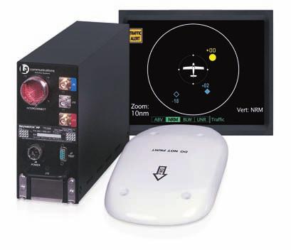
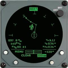
4 STORMSCOPE MODEL WX-950 If you like a dedicated, always on display, the WX-950 is the Stormscope system for you. The WX-950 provides two modes of operation cell mode and strike mode. In cell mode, it detects lightning up to 200 nautical miles out and displays storm cell areas of greatest intensity. During periods of heavy electrical activity, cell mode clearly indicates if there is a path to safely avoid thunderstorms. In strike mode, the WX-950 detects and maps individual strikes, allowing you to monitor sporadic electrical activity that may indicate the beginnings of a storm. Ranges of 25, 50, 100 and 200 nm are available in 360 view or 120 forward looking view. > Operates in 25, 50, 100 and 200 nm ranges > Features pilot selectable strike and cell modes > Displays multiple views: 360 view of electrical activity in all directions forward looking 120 view > Uses a high resolution, 3-inch ATI display/processor for optimum image precision > Heading stabilized when configured with a compatible heading system STORMSCOPE MODEL WX-1000 SERIES Now you don t have to be a meteorologist to forecast the weather. Like all Stormscope systems, the WX-1000 Series provides early detection of storm cells, and displays lightning at ranges up to 200 nautical miles. Simply turn your system on and monitor thunderstorm activity even before you leave the ground. Pick four selectable ranges, two separate views, a built-in checklist, and a timer to keep track of your elapsed time on approach. The WX-1000E Series can be configured to display lightning on an EFIS or radar indicator. > 360 or 120 selectable view out to 200 nm range > Interfaces with the L-3 SkyWatch and SkyWatch HP Traffic Advisory Systems > Electrical discharge information acquired and stored on all ranges simultaneously > CLEAR function aids in determining whether storm cells are building or dissipating > Optional dedicated high resolution CRT display with adjustable brightness control > Six installer-programmable checklists > Recognized by the military as the AN/AMS-2 and carries national stock numbers (1,2) > Heading stabilized when configured with a compatible heading system (1,2) > Uses an RS232 or RS422 input from a compatible Loran/GPS (2) > Available with ARINC 429 EFIS output (2) > Creates Loran/GPS-generated Course Deviation Indicator (CDI) (2) (1) Model WX features (2) Model WX-1000E features Stormscope WX-1000E with optional 429 EFIS output
5 SKYWATCH COLLISION AVOIDANCE SYSTEMS When you combine the SkyWatch or SkyWatch HP collision avoidance systems with your Stormscope system, you can monitor both thunderstorm activity and traffic threats that surround your aircraft all on the same display. Designed to meet the needs of today's cockpits and those of the future, SkyWatch and SkyWatch HP are the ideal match for Stormscope to give you a clear view ahead. SKYWATCH WITH STORMSCOPE WX When combining the SkyWatch or SkyWatch HP Traffic Avoidance Systems with a Stormscope WX-1000+, pilots have the ability to monitor both thunderstorm activity and traffic threats, all on the same bright and compact 3" CRT display. The WX automatically displays SkyWatch information when a Traffic Advisory (TA) is present, reverting back to Stormscope mode when the TA is no longer a threat. Pilots can also toggle between lightning and traffic information through the use of a panel mounted switch. Additionally, the WX-1000E 429 EFIS matched with the SkyWatch HP system allows pilots to view lightning and traffic information on select ARINC 429 EFIS displays. SkyWatch HP displayed on the WX-1000 Display SKYWATCH WITH STORMSCOPE WX-500 SkyWatch and Stormscope WX-500 information overlaid on typical MFD Using your Stormscope WX-500 to display lightning on an MFD or Radar Indicator? Adding SkyWatch or SkyWatch HP to your system enables traffic to be displayed simultaneously on these displays. The range and operating modes of the SkyWatch and Stormscope WX-500 systems are controlled directly through the MFD or radar indicator controller (using the RGC350). View traffic and lightning overlaid on the MFD s moving map or on a dedicated page. Both SkyWatch and Stormscope information can be superimposed over the precipitation returns displayed on your compatible weather radar indicator.
6 SYSTEM SPECIFICATIONS DIMENSIONS DISPLAY WX-500 WX-950 (a standard 3ATI instrument) 3.37" (8.6 cm) high 3.37" (8.6 cm) wide 11.46" (29.11 cm) deep including connector backshell WX-1000 Series II 3.37" (8.6 cm) high 3.37" (8.6 cm) wide 8.25" (21 cm) deep ANTENNA 1.00" (2.54 cm) high 3.5" (8.76 cm) wide 6.9" (17.40 cm) long 1.00" (2.54 cm) high 3.5" (8.76 cm) wide 6.9" (17.40 cm) long 1.13" (2.9 cm) high 4.49" (11.4 cm) wide 10.06" (25.6 cm) long PROCESSOR 5.6" (14.22 cm) high 2.2" (5.59 cm) wide 12" (30.48 cm) deep (including mounting tray and pull handle) 3.38" (8.6 cm) high 4.88" (12.4 cm) wide 12.67" (32.2 cm) long WEIGHT PROCESSOR DISPLAY 2.5 lbs (1.13 kg) (including mounting tray) 2.9 lbs (1.3 kg) 6.67 lbs (3.02 kg) (including mounting tray) 2.28 lbs (1.03 kg) ANTENNA 0.84 lbs (0.38 kg) (without doubler) 0.84 lbs (0.38 kg) (without doubler) 2.00 lbs (.91 kg) (with doubler) ELECTRICAL CHARACTERISTICS Input Voltage: 11 to 32 VDC Current: 0.82 A 12 VDC 0.38 A 28 VDC Input Voltage: 11 to 32 VDC Current: 2.0 A ± VDC 0.8 A ± VDC Input Voltage: 10.5 to 32 VDC Power Consumption: 28 WATTS Gyro excitation (400 Hz): 5-50 VOLTS-pk SPECIFICATION COMPLIANCE Complies with FAA TSO C110A JTSO Approved Complies with FAA TSO C110A Various foreign approvals Complies with FAA TSO C110A Various foreign approvals ENVIRONMENTAL CHARACTERISTICS Remote Processor: -55 to +70 C (-67 to +158 F) Display/Processor: -20 to +55 C (-4 to +131 F) 35,000 feet MSL maximum Processor: -55 C (min), +70 C (max) Display: -20 C (min), +55 C (max) Antenna: -55 to +70 C (-67 to +158 F) Antenna: -55 to +70 C (-67 to +158 F) Antenna: -55 C (min), +70 C (max) Operational Altitude: nd Street, S.E. Grand Rapids, MI Telephone: FAX: This brochure consists of L-3 Avionics Systems Inc., general capabilities information that does not contain controlled technical data as defined within the International Traffic in Arms (ITAR) Part or Export Administration Regulations (EAR) Part
SPOT THE PROBLEM. TRAFFIC, TRAFFIC - 5 O CLOCK LOW - 2 MILES
 SPOT THE PROBLEM. For nearly 15 years, pilots have trusted SkyWatch Collision Avoidance Systems to enhance safety by helping them spot traffic. SkyWatch was the first Active Collision Avoidance System
Safety in Numbers SKYWATCH 497. The affordable original.
 SKYWATCH 497 Safety in Numbers The affordable original. For over 10 years, pilots have trusted SkyWatch Collision Avoidance Systems to help them fly safely. SkyWatch was the first Active Collision Avoidance
LANDMARK TM. Class B TAWS
 LANDMARK TM Class B TAWS WAAS-GPS Accurate - 320 Mile Range - Easily Integrated Introducing the LandMark Model 8100 LandMark is the first stand-alone Class B TAWS to offer an optional WAAS-GPS sensor.
TRAFFIC,TRAFFIC - 5 O CLOCK LOW - 2 MILES
 SPOT THE PROBLEM. For more than a decade, pilots have trusted SkyWatch Collision Avoidance Systems to enhance safety by helping them spot traffic. SkyWatch was the first Active Collision Avoidance System
User s Guide. for the. Stormscope. Series II Weather Mapping Sensor. Model WX-500
 User s Guide for the Stormscope Series II Weather Mapping Sensor Model WX-500 Stormscope System Advantages Welcome L-3 Avionics Systems, one of the world s most experienced companies in airborne thunderstorm
L-3 Avionics Systems SkyWatch Traffic Advisory System
 Cirrus Design Section 9 Pilot s Operating Handbook and FAA Approved Airplane Flight Manual Supplement for L-3 Avionics Systems SkyWatch Traffic Advisory System When the L-3 Avionics Systems SkyWatch 497
Pilot s Guide. for the. Stormscope. Series II Weather Mapping System. Model WX-950 BRT OFF CELL MENU CLR. 200nm
 Pilot s Guide for the Stormscope Series II Weather Mapping System Model WX-950 Rate: 20 CELL 25 200nm Important Notices This data is provided at no charge, or at cost, to the public and is considered publicly
$12.00 U.S. Pilot s Guide. for the. Stormscope. Series II Weather Mapping System. Model WX-1000
 $12.00 U.S. Pilot s Guide for the Stormscope Series II Weather Mapping System Model WX-1000 Stormscope System Advantages Welcome The Original BFGoodrich Avionics Systems, one of the world s most experienced
Pilot s Guide. for the. Stormscope. Series II Weather Mapping System. Model WX-1000
 Pilot s Guide for the Stormscope Series II Weather Mapping System Model WX-1000 Stormscope System Advantages Welcome L-3 Avionics Systems, one of the world s most experienced companies in airborne thunderstorm
Section 7: Hazard Avoidance
 7.1 In-Flight Hazard Awareness Section 7: Hazard Avoidance As technology improves, pilots have more and more real-time information within reach in all phases of flight. Terrain proximity, real-time weather
Columbia 350, 400 Multi-Function Display Pilot s Guide
 600-00102-000 Rev. 09 Columbia 350, 400 Multi-Function Display Pilot s Guide Document Revision History Date Revision Description Jul 22, 2003 00 Released per ECO-03-188 Sept 11, 2003 01 Updated per ECO-03-225
B KMD 550/850 Multi-Function Display Quick Reference For Software Version 01/14 or Later
 F N B KMD 550/850 Multi-Function Display Quick Reference For Software Version 01/14 or Later 12 1 11 2 3 4 10 13 9 6 5 7 1. Brightness Control 2. Data Card 3. Display 4. Available Functions Legend 5. On/Off
KMD 550/850 Multi-Function Display Quick Reference For Software Version 01/11 or Later
 F B KMD 550/850 Multi-Function Display Quick Reference For Software Version 01/11 or Later 12 1 11 N 2 3 4 10 13 9 6 5 7 1. Brightness Control 2. Data Card 3. Display 4. Available Functions Legend 5. On/Off
ENSTROM 480B OPERATOR S MANUAL AND FAA APPROVED ROTORCRAFT FLIGHT MANUAL SUPPLEMENT GARMIN GDL 69AH XM WX SATELLITE WEATHER/RADIO RECEIVER
 ENSTROM 480B OPERATOR S MANUAL AND FAA APPROVED ROTORCRAFT FLIGHT MANUAL SUPPLEMENT GARMIN GDL 69AH XM WX SATELLITE WEATHER/RADIO RECEIVER * * * * * REPORT NO. 28-AC-062 HELICOPTER SERIAL NO. HELICOPTER
United Airlines Vision for Weather Decision Making
 United Airlines Vision for Weather Decision Making Captain Joe Burns Managing Director Technology and Flight Test FPAW - Oct. 24, 2013 Overview What are the potential WDM datalinks? EFB programs Flight
Weather Radar The Next 10 Years NBAA 2012, Orlando Florida
 Copyright 2010 Rockwell Collins, Inc. All rights reserved. Weather Radar The Next 10 Years NBAA 2012, Orlando Florida Craig Peterson Director of Avionics Marketing Rockwell Collins Radar (Historical Perspective)
Meteorology. Review Extreme Weather a. cold front. b. warm front. What type of weather is associated with a:
 Meteorology 5.08 Extreme Weather References: FTGU pages 132, 144, 145, 148-155 Air Command Weather Manual Chapters 9 and 15 Review What type of weather is associated with a: a. cold front b. warm front
Accident Prevention Program
 Thunderstorm Accident Prevention Program Thunderstorms - Don't Flirt...Skirt'Em Pilot's Beware! Within the route you intend to fly may lie a summer hazard in wait for the unwary--the Thunderstorm. The
TOPICS: What are Thunderstorms? Ingredients Stages Types Lightning Downburst and Microburst
 THUNDERSTORMS TOPICS: What are Thunderstorms? Ingredients Stages Types Lightning Downburst and Microburst What are Thunderstorms? A storm produced by a cumulonimbus cloud that contains lightning and thunder
Weather Technology in the Cockpit (WTIC) Shortfall Analysis of Weather Information in Remote Airspace Friends and Partners of Aviation Weather Summer
 Shortfall Analysis of Weather Information in Remote Airspace Friends and Partners of Aviation Weather Summer") Weather Technology in the Cockpit (WTIC) Shortfall Analysis of Weather Information in Remote Airspace Friends and Partners of Aviation Weather Summer Meeting Tim Myers Metron Aviation August 26, 2015 2
Weather Technology in the Cockpit (WTIC) Shortfall Analysis of Weather Information in Remote Airspace Friends and Partners of Aviation Weather Summer Meeting Tim Myers Metron Aviation August 26, 2015 2
COLLINS WXR-2100 MULTISCAN RADAR FULLY AUTOMATIC WEATHER RADAR. Presented by: Rockwell Collins Cedar Rapids, Iowa 52498
 COLLINS WXR-2100 MULTISCAN RADAR FULLY AUTOMATIC WEATHER RADAR Presented by: Rockwell Collins Cedar Rapids, Iowa 52498 TABLE OF CONTENTS MultiScan Overview....................................................................................1
Multi-Function Display Pilot s Guide Addendum
 Multi-Function Display Pilot s Guide Addendum Software Release 4.2 or Later 600-00344-000 Rev: 01-1- EX500/EX600 Document Revision History Date Revision Description February 21, 2018 00 Initial Release
Reprint 797. Development of a Thunderstorm. P.W. Li
 Reprint 797 Development of a Thunderstorm Nowcasting System in Support of Air Traffic Management P.W. Li AMS Aviation, Range, Aerospace Meteorology Special Symposium on Weather-Air Traffic Management Integration,
Multi-Function Display Pilot s Guide Addendum
 Multi-Function Display Pilot s Guide Addendum Software Release 8.1 600-00248-000 Rev: 01 600-00248-000 Rev: 01-1- Entegra EX5000 Document Revision History Date Revision Description Nov. 13, 2009 00 Initial
Gleim Private Pilot FAA Knowledge Test 2015 Edition, 1st Printing Updates July 2015
 Page 1 of 6 Gleim Private Pilot FAA Knowledge Test 2015 Edition, 1st Printing Updates July 2015 NOTE: Deleted text is displayed with a line through it. New text is shown with a blue background. If you
Use of radar to detect weather
 2 April 2007 Welcome to the RAP Advisory Panel Meeting Use of radar to detect weather G. Brant Foote Brant Director Foote Rita Roberts Roelof Bruintjes Research Applications Program Radar principles Radio
Rev 07. Cirrus SR20 and SR22 Multi-Function Display Pilot s Guide
 600-00108-000 Rev 07 Cirrus SR20 and SR22 Multi-Function Display Pilot s Guide Document Revision History Date Revision Description Mar. 09, 2004 00 Initial Release Mar. 23, 2004 01 Updated per ECO 04-049
Weather Legends in FOREFLIGHT MOBILE
 Weather Legends in FOREFLIGHT MOBILE 14th Edition Covers ForeFlight Mobile v9.4 on ipad Radar Legends (when from Internet) Snowy/Icy Precipitation Mixed Precipitation Rain Echo top (in 100 s of feet) ex:
Marine Corps Installations East Regional METOC Center MCAS Cherry Point, NC Standardized Weather Warnings Definitions
 Marine Corps Installations East Regional METOC Center MCAS Cherry Point, NC Standardized Weather Warnings Definitions Updated: 25 June 2012 MCIE Standardized Weather Warnings Warning Local Wind Warning
AWOS Level Descriptions
 AWOS Level Descriptions AWOS System Configurations. The AWOS is a modular system utilizing a central processor which may receive input from several sensors. Eight standard groups of sensors are defined
THUNDERSTORMS. Convective heavy rain accompanied by lightning and thunder. Ahrens
 THUNDERSTORMS Convective heavy rain accompanied by lightning and thunder Ahrens Thunderstorms About 1,800 T-storms occur around the world at any instant Where do they occur the most? National Lightning
Turbulence Avoidance Technologies
 Turbulence Avoidance Technologies The information contained herein is advisory only in nature. Modification Date: 01NOV2016 Revision: 0.0 Operations Scope: ALL AIRCRACT Briefing Owners: Tenille Cromwell
Complete Weather Intelligence for Public Safety from DTN
 Complete Weather Intelligence for Public Safety from DTN September 2017 White Paper www.dtn.com / 1.800.610.0777 From flooding to tornados to severe winter storms, the threats to public safety from weather-related
ForeFlight Mobile Legends
 ForeFlight Mobile Legends ForeFlight, LLC 11th Edition - Covers ForeFlight Mobile v8.1 and later RADAR LEGENDS (WHEN FROM INTERNET) Snowy/Icy Precipitation Mixed Precipitation Rain Echo top (in 100 s of
Meteorology. Chapter 10 Worksheet 2
 Chapter 10 Worksheet 2 Meteorology Name: Circle the letter that corresponds to the correct answer 1) Downdrafts totally dominate the in the development of a thunderstorm. a) dissipating stage b) mature
GNS 400W/500W Series SW V5.00 Upgrade Supplement
 GNS 400W/500W Series SW V5.00 Upgrade Supplement This supplement provides information regarding new features of software version 5.00 for 400W/500W Series units. The Pilot s Guide and Garmin Displays Addendum
INDUSTRY. Bullies. Lightning & Turbulence
 INDUSTRY Avoiding the Bullies Lightning & Turbulence 28 avionics news november 2010 S T O R Y B Y D A V E H I G D O N Fly enough hours and chances grow for a pilot to face weather conditions preferably
ADL110B ADL120 ADL130 ADL140 How to use radar and strike images. Version
 ADL110B ADL120 ADL130 ADL140 How to use radar and strike images Version 1.00 22.08.2016 How to use radar and strike images 1 / 12 Revision 1.00-22.08.2016 WARNING: Like any information of the ADL in flight
TWX670 Tactical Weather Detection System Pilot s Operating Handbook
 TWX670 Tactical Weather Detection System Pilot s Operating Handbook P/N 600-00164-000 Rev 010 1 This handbook contains basic operating instructions for the TWX670 system. The TWX670 processor interfaces
AOG Add On Gauges FSWXR-2100 Users Manual Rev. 1.0 FSWXR Users Manual Rev. 1.0
 FSWXR 2100 Users Manual Rev. 1.0 Realistic simulation of the real Collins WXR2100 for Microsoft Flightsimulator 9 AOG FSWXR2100 Page 1 1. Introduction Weather is the one of uncontrollable factors in aviation.
Complementary Use of Airborne Wx Radar & Datalink Graphical Wx
 Complementary Use of Airborne Wx Radar & Datalink Graphical Wx What if to What next? Cheri Haynes XCELAR Friends/Partners in Aviation Weather Forum October 31, 2012 What if to What next? Today there are
Weather Legends in FOREFLIGHT MOBILE
 Weather Legends in FOREFLIGHT MOBILE 15th Edition Covers ForeFlight Mobile v9.6 on ipad Radar Legends (when from Internet) Snowy/Icy Precipitation Mixed Precipitation Rain Echo top (in 100 s of feet) ex:
Recap: Electric Field Lines Positive Charge: field lines outwards direction Negative Charge: converge F + In both cases density
 Recap: Electric Field Lines Concept of electric field lines initially used by Michael Faraday (19 th century) to aid visualizing electric (and magnetic) forces and their effects. James Clerk Maxwell (19
SAMPLE. SITE SPECIFIC WEATHER ANALYSIS Rainfall Report. Bevins Engineering, Inc. Susan M. Benedict. July 1, 2017 REFERENCE:
 SAMPLE SITE SPECIFIC WEATHER ANALYSIS Rainfall Report PREPARED FOR: Bevins Engineering, Inc. Susan M. Benedict July 1, 2017 REFERENCE: DUBOWSKI RESIDENCE / FILE# 11511033 1500 Water Street, Pensacola,
Federal Aviation Administration
 High Ice Water Content Research International Collaboration and Field Campaign Presented to: FPAW By: Tom Bond Date: Statement of Need Over the past 10+ years, it has been recognized that jet engine powerloss
Pilot s Guide. for the. Class B Terrain Awareness & Warning System. Model TAWS8000
 Pilot s Guide for the Class B Terrain Awareness & Warning System Model TAWS8000 Forward Looking Technology The FAA Mandate Studies of Controlled Flight Into Terrain (CFIT) accidents ultimately led to the
The Ice Crystal Weather Threat to Engines
 Jeanne Mason Boeing Commercial Airplanes The Ice Crystal Weather Threat to Engines BOEING is a trademark of Boeing Management Company. Filename.ppt 1 Agenda Introduction Recognition of engine power-loss
SAMPLE. SITE SPECIFIC WEATHER ANALYSIS Wind Report. Robinson, Smith & Walsh. John Smith. July 1, 2017 REFERENCE: 1 Maple Street, Houston, TX 77034
 SAMPLE SITE SPECIFIC WEATHER ANALYSIS Wind Report PREPARED FOR: Robinson, Smith & Walsh John Smith July 1, 2017 REFERENCE: JACK HIGGINS / 4151559-01 1 Maple Street, Houston, TX 77034 CompuWeather Sample
WSI Pilotbrief Optima - for ipad
 WSI Pilotbrief Optima - for ipad Anticipate, Visualize & Avoid Hazardous Weather In A Whole New Way The Weather Company, an IBM Business, delivers an ipad-based version of WSI Pilotbrief Optima. This ipad
Thunderstorm. Thunderstorms result from the rapid upward movement of warm, moist air.
 Severe Weather Thunderstorm A thunderstorm (aka an electrical storm, a lightning storm, or a thundershower) is a type of storm characterized by the presence of lightning and its acoustic effect, thunder.
Advances in Weather Technology
 Advances in Weather Technology Dr. G. Brant Foote National Center for Atmospheric Research 16 May 2001 NCAR Research Results in Aviation Weather Built on the foundation of the nation s long-standing investment
6 WHY USE A STORMSCOPE? With that nifty NEXRAD downlink, is your Stormscope a paperweight? Not at all.
 Volume 21 Number 8 August 2005 The Magazine for the Accomplished Pilot 6 WHY USE A STORMSCOPE? With that nifty NEXRAD downlink, is your Stormscope a paperweight? Not at all. 9 MIXING WITH THE HEAVIES Sometimes
STUDY UNIT SEVENTEEN GRAPHICAL AIRMAN S METEOROLOGICAL ADVISORY (G-AIRMET)
") STUDY UNIT SEVENTEEN GRAPHICAL AIRMAN S METEOROLOGICAL ADVISORY (G-AIRMET) 341 (10 pages of outline) 17.1 Product Description....................................................... 341 17.2 Issuance...............................................................
STUDY UNIT SEVENTEEN GRAPHICAL AIRMAN S METEOROLOGICAL ADVISORY (G-AIRMET) 341 (10 pages of outline) 17.1 Product Description....................................................... 341 17.2 Issuance...............................................................
Aircraft Icing FAR/CS-25, Appendix O and P charts
 Aircraft Icing FAR/CS-25, Appendix O and P charts Prof. Dr. Serkan ÖZGEN Dept. Aerospace Engineering, METU Fall 2015 Outline Appendix O and P - Background Existing CS-25 certification specifications for
ATS 351, Spring 2010 Lab #11 Severe Weather 54 points
 ATS 351, Spring 2010 Lab #11 Severe Weather 54 points Question 1 (10 points): Thunderstorm development a) Sketch and describe the stages of development of a single cell thunderstorm. About how long does
P1.1 THE NATIONAL AVIATION WEATHER PROGRAM: AN UPDATE ON IMPLEMENTATION
 P1.1 THE NATIONAL AVIATION WEATHER PROGRAM: AN UPDATE ON IMPLEMENTATION Thomas S. Fraim* 1, Mary M. Cairns 1, and Anthony R. Ramirez 2 1 NOAA/OFCM, Silver Spring, MD 2 Science and Technology Corporation,
B KMD 550/850 Multi-Function Display Quick Reference For Software Version 02/01 or Later
 F N B KMD 550/850 Multi-Function Display Quick Reference For Software Version 02/01 or Later 12 1 11 2 3 4 10 13 9 6 5 7 1. Brightness Control 2. Data Card 3. Display 4. Available Functions Legend 5. On/Off
SAMPLE. SITE SPECIFIC WEATHER ANALYSIS Rainfall Report. Bevens Engineering, Inc. Susan M. Benedict REFERENCE:
 SAMPLE SITE SPECIFIC WEATHER ANALYSIS Rainfall Report PREPARED FOR: Bevens Engineering, Inc. Susan M. Benedict REFERENCE: DUBOWSKI RESIDENCE / FILE# 11511033 CompuWeather Sample Report Please note that
A Description of Convective Weather Containing Ice Crystals Associated with Engine Powerloss and Damage
 A Description of Convective Weather Containing Ice Crystals Associated with Engine Powerloss and Damage The Boeing Company 1 Photo: courtesy of Ian McPherson The Boeing Company acknowledges the contributions
DESIGNED FOR EASY INTEGRATION HOW TO GET STARTED. Global Data Products
 DESIGNED FOR EASY INTEGRATION The easy-to-implement Baron Weather API allows precision aviation weather information to be added to any of your websites, apps or software. Backed by extensive documentation
Network Severe Weather Programme
 Network Severe Weather Programme David White Network Severe Weather programme Severe Weather is an EVENT with associated Uncertainty which requires Managing to protect the ATC environment & the integrity
Effectively Using ADS-B. How to best utilize cockpit weather and traffic
 Effectively Using ADS-B How to best utilize cockpit weather and traffic Presentation Outline ADS-B Overview Traffic (TIS-B) Weather (FIS-B) Coverage Maps Spherics Overview Operating Modes Datalink Traffic
B KMD 550/850 Multi-Function Display Quick Reference For Software Version 01/14 or Later
 F N B KMD 550/850 Multi-Function Display Quick Reference For Software Version 01/14 or Later 12 1 11 2 3 4 10 13 9 6 5 7 1. Brightness Control 2. Data Card 3. Display 4. Available Functions Legend 5. On/Off
WMO/ICAO AMF Competencies
 WMO/ICAO AMF Competencies Workshop on Aeronautical Competencies and SIGMETs August 26 st, 2015 Karine Dumas Meteorological Service of Canada Montreal Competency Hierarchy Top-level Competencies WMO 49
The next generation in weather radar software.
 The next generation in weather radar software. PUBLISHED BY Vaisala Oyj Phone (int.): +358 9 8949 1 P.O. Box 26 Fax: +358 9 8949 2227 FI-00421 Helsinki Finland Try IRIS Focus at iris.vaisala.com. Vaisala
AOPA. Mitigating Turbulence Impacts in Aviation Operations. General Aviation Perspective
 AOPA Mitigating Turbulence Impacts in Aviation Operations General Aviation Perspective Rune Duke Senior Director, Airspace & Air Traffic Services Aircraft Owners & Pilots Association AOPA Air Safety Institute
SAMPLE. SITE SPECIFIC WEATHER ANALYSIS Wind Report. Robinson, Smith & Walsh. John Smith REFERENCE:
 SAMPLE SITE SPECIFIC WEATHER ANALYSIS Wind Report PREPARED FOR: Robinson, Smith & Walsh John Smith REFERENCE: JACK HIGGINS / 4151559-01 CompuWeather Sample Report Please note that this report contains
Doppler Weather Radars and Weather Decision Support for DP Vessels
 Author s Name Name of the Paper Session DYNAMIC POSITIONING CONFERENCE October 14-15, 2014 RISK SESSION Doppler Weather Radars and By Michael D. Eilts and Mike Arellano Weather Decision Technologies, Inc.
Pilots watch the clouds, because clouds can indicate the kind of weather in store for a flight.
 Low stratus Cumulonimbus Pilots watch the clouds, because clouds can indicate the kind of weather in store for a flight. FILL IN THE BLANKS OR CIRCLE ONE: A. Stratus means flat or on one level. Low stratus
Severe Weather Watches, Advisories & Warnings
 Severe Weather Watches, Advisories & Warnings Tornado Watch Issued by the Storm Prediction Center when conditions are favorable for the development of severe thunderstorms and tornadoes over a larger-scale
ON LINE ARCHIVE OF STORM PENETRATING DATA
 ON LINE ARCHIVE OF STORM PENETRATING DATA Matthew Beals, Donna V. Kliche, and Andrew G. Detwiler Institute of Atmospheric Sciences, South Dakota School of Mines and Technology, Rapid City, SD Steve Williams
Chapter 14 Thunderstorm Fundamentals
 Chapter overview: Thunderstorm appearance Thunderstorm cells and evolution Thunderstorm types and organization o Single cell thunderstorms o Multicell thunderstorms o Orographic thunderstorms o Severe
473 Dew Point Hygrometer
 gh Performance Chilled Hygrometer With Cable Mounted Measuring Heads ghly precise chilled mirror dew point technology Cable mounted dew point and temperature measurement Aspirated and direct insertion
Use of lightning data to improve observations for aeronautical activities
 Use of lightning data to improve observations for aeronautical activities Françoise Honoré Jean-Marc Yvagnes Patrick Thomas Météo_France Toulouse France I Introduction Aeronautical activities are very
Advanced Weather Technology
 Advanced Weather Technology Tuesday, October 16, 2018, 1:00 PM 2:00 PM PRESENTED BY: Gary Pokodner, FAA WTIC Program Manager Agenda Overview Augmented reality mobile application Crowd Sourcing Visibility
The Montague Doppler Radar, An Overview
 ISSUE PAPER SERIES The Montague Doppler Radar, An Overview June 2018 NEW YORK STATE TUG HILL COMMISSION DULLES STATE OFFICE BUILDING 317 WASHINGTON STREET WATERTOWN, NY 13601 (315) 785-2380 WWW.TUGHILL.ORG
FPAW October Pat Murphy & David Bright NWS Aviation Weather Center
 FPAW October 2014 Pat Murphy & David Bright NWS Aviation Weather Center Overview Ensemble & Probabilistic Forecasts What AWC Is Doing Now Ensemble Processor What s In Development (NOAA Aviation Weather
Unique Vaisala Global Lightning Dataset GLD360 TM
 Unique Vaisala Global Lightning Dataset GLD360 TM / THE ONLY LIGHTNING DETECTION NETWORK CAPABLE OF DELIVERING HIGH-QUALITY DATA ANYWHERE IN THE WORLD GLD360 provides high-quality lightning data anywhere
Weather in the Connected Cockpit
 Weather in the Connected Cockpit What if the Cockpit is on the Ground? The Weather Story for UAS Friends and Partners of Aviation Weather November 2, 2016 Chris Brinton brinton@mosaicatm.com Outline Mosaic
M o d u l e k A i r c r a f t A e r o d y n a m i c s, S t r u c t u r e s a n d S y s t e m s
 Category A B1 B2 B3 08 Instrument systems (ATA 31) Level 1 2 3 M o d u l e 1 3-0 8 k A i r c r a f t A e r o d y n a m i c s, S t r u c t u r e s a n d S y s t e m s I n s t r u m e n t S y s t e m s -
FLYSAFE meteorological hazard nowcasting driven by the needs of the pilot
 FLYSAFE meteorological hazard nowcasting driven by the needs of the pilot R. W. Lunnon, Met Office, Exeter, EX1 3PB, United Kingdom., Thomas Hauf, Thomas Gerz, and Patrick Josse. 1. Introduction The FLYSAFE
Guidance to Instructors on Subject Delivery PILOT NAVIGATION. This is a suggested programme for the delivery of this subject.
 Programme of learning: Guidance to Instructors on Subject Delivery This is a suggested programme for the delivery of this subject. The main headings are the Learning Outcomes (LO1, LO2, etc), with sub
Remote Oceanic Meteorology Information Operational (ROMIO) Demonstration
 Demonstration") Remote Oceanic Meteorology Information Operational (ROMIO) Demonstration Federal Aviation Administration Provided to: Turbulence Impact Mitigation Workshop 3 By: Eldridge Frazier, WTIC Program, ROMIO Demo
Remote Oceanic Meteorology Information Operational (ROMIO) Demonstration Federal Aviation Administration Provided to: Turbulence Impact Mitigation Workshop 3 By: Eldridge Frazier, WTIC Program, ROMIO Demo
NextGen Update. Cecilia Miner May, 2017
 NextGen Update Cecilia Miner May, 2017 Agenda What s changed? NextGen Background FAA NextGen Weather Architecture NextGen Weather Processor Aviation Weather Display Common Support Services - Weather NWS
The Avian Hazard Advisory System
 101 The Avian Hazard Advisory System T. Adam Kelly a, Ronald Merritt a, Maj Thomas J. Donalds b and Ronald L. White a a 3160 Airport Rd, Suite 22-A, Panama City, FL, 32405 b 4th Wing, Seymour Johnson AFB,
473 Dew Point Hygrometer
 High Performance Chilled Mirror Hygrometer With Cable Mounted Measuring Heads Highly precise chilled mirror dew point technology Cable mounted dew point and temperature measurement Aspirated and direct
Enhanced Weather Radar (EWxR) System
 System") NASA/CR-2003-212406 Enhanced Weather Radar (EWxR) System Kevin M. Kronfeld Rockwell Collins, Cedar Rapids, Iowa June 2003 The NASA STI Program Office... in Profile Since its founding, NASA has been dedicated
NASA/CR-2003-212406 Enhanced Weather Radar (EWxR) System Kevin M. Kronfeld Rockwell Collins, Cedar Rapids, Iowa June 2003 The NASA STI Program Office... in Profile Since its founding, NASA has been dedicated
CHAPTER 11 THUNDERSTORMS AND TORNADOES MULTIPLE CHOICE QUESTIONS
 CHAPTER 11 THUNDERSTORMS AND TORNADOES MULTIPLE CHOICE QUESTIONS 1. A thunderstorm is considered to be a weather system. a. synoptic-scale b. micro-scale c. meso-scale 2. By convention, the mature stage
SAMPLE. SITE SPECIFIC WEATHER ANALYSIS Slip and Fall on Snow/Ice. Robinson, Smith & Walsh. John Smith. July 1, 2017 REFERENCE:
 SAMPLE SITE SPECIFIC WEATHER ANALYSIS Slip and Fall on Snow/Ice PREPARED FOR: Robinson, Smith & Walsh John Smith July 1, 2017 REFERENCE: MARIE DAVIDSON / 202301 1 Jackson Drive, Hicksville, NY 11801 CompuWeather
Severe Weather Potential for Southeast Texas
 Severe Weather Potential for Southeast Texas Dan Reilly, Kent Prochazka, Scott Overpeck National Weather Service Houston/Galveston 10 am Synopsis Storm to likely bring severe weather to Southeast Texas
3 Severe Weather. Critical Thinking
 CHAPTER 2 3 Severe Weather SECTION Understanding Weather BEFORE YOU READ After you read this section, you should be able to answer these questions: What are some types of severe weather? How can you stay
Issue of SIGMET/AIRMET warning
 Issue of SIGMET/AIRMET warning 1 Presentation Objectives After this presentation session you will be able to: Warn for Hazardous weather phenomena using the correct ICAO coding with regards to SIGMET/AIRMET
May 17, earthsciencechapter24.notebook. Apr 8 10:54 AM Review. Grade:9th. Subject:Earth Science. Date:4/8.
 Apr 8 10:54 AM 24.1 Review Grade:9th Subject:Earth Science Date:4/8 Apr 8 9:29 AM 1 1 As lower layers of air are warmed... A the air rises B winds form C the air dries D the air sinks Apr 8 9:49 AM 2 What
Answer Key. Page 1 of 5
 Answer Key Name: Score: [1] When telephoning a weather briefing facility for preflight weather information, pilots should state A. whether they intend to fly VFR only. B. the full name and address of the
Aviation Hazards: Thunderstorms and Deep Convection
 Aviation Hazards: Thunderstorms and Deep Convection TREND Diagnosis of thunderstorm hazards using imagery Contents Satellite imagery Visible, infrared, water vapour Basic cloud identification Identifying
HAZARDOUS WEATHER 1. Dr. Julie Laity Geography 266
 HAZARDOUS WEATHER 1 Dr. Julie Laity Geography 266 Violent Weather Thunderstorms Atmospheric turbulence Lightning and thunder Hail Derechos Tornadoes Tornado measurement and science Tropical Cyclones Hurricanes
4A.1 RESULTS OF THE NATIONAL AVIATION WEATHER PROGRAM S 10-YEAR GOAL TO REDUCE WEATHER-RELATED ACCIDENTS BY 80 PERCENT
 4A.1 RESULTS OF THE NATIONAL AVIATION WEATHER PROGRAM S 10-YEAR GOAL TO REDUCE WEATHER-RELATED ACCIDENTS BY 80 PERCENT Samuel P. Williamson, Judson E. Stailey*, and Mark J. Welshinger Office of the Federal
ACTIVITY. Weather Radar Investigation. Additional Activities
 ACTIVITY Introduction Approach Activity Weather Radar Investigation Radar is an important weather observing tool 1. Construct a Radar Screen slide chart by used to locate areas of precipitation and to
Vaisala Blitzdetektion. Michael Kalkum
 Vaisala Blitzdetektion Michael Kalkum 12.11.2013 What Is Lightning? Lightning is a transient, high-current electrical discharge Lightning stroke is typically 30.000 C Lightning takes the path of least
Montréal, 7 to 18 July 2014
 INTERNATIONAL CIVIL AVIATION ORGANIZATION WORLD METEOROLOGICAL ORGANIZATION 6/5/14 Meteorology (MET) Divisional Meeting (2014) Commission for Aeronautical Meteorology Fifteenth Session Montréal, 7 to 18