Selected Presentation from the INSTAAR Monday Noon Seminar Series.
|
|
|
- Rhoda Stevenson
- 5 years ago
- Views:
Transcription
1 Selected Presentation from the INSTAAR Monday Noon Seminar Series. Institute of Arctic and Alpine Research, University of Colorado at Boulder. This seminar presentation has been posted to the internet to foster communication with the science community and the public. Most of the INSTAAR presentations were originally given in PowerPoint format; they were converted to Adobe PDF for posting. You may need to install the free Adobe Acrobat Reader to view these files. These presentations are "works in progress". They are not peer reviewed. They should not be referenced for any kind of publication. Contact the author for proper references and additional information before any use, even for unpublished works such as your own presentations. LICENSING AGREEMENT. Free use of these presentations is limited to a nonprofit educational or private non-commercial context and requires that you contact the author, give credit to the author, and display the copyright notice. All rights to reproduce these presentations are retained by the copyright owner. Images remain the property of the copyright holder. By accessing these presentations, you are consenting to our licensing agreement. 01 Nov Steve Goodbred, State Univ. of New York, Stony Brook, sgoodbred@notes.cc.sunysb.edu "The Ganges-Brahmaputra sediment dispersal system: Controls, responses, and stratigraphy during the Late Quaternary". Seminar given at INSTAAR, University of Colorado. Copyright 2002 Steve Goodbred. All Rights Reserved. Goodbred presentation (3.6 Mb PDF).
2 Selected Presentation from the INSTAAR Monday Noon Seminar Series. Institute of Arctic and Alpine Research, University of Colorado at Boulder Nov Steve Goodbred, State Univ. of New York, Stony Brook, "The Ganges-Brahmaputra sediment dispersal system: Controls, responses, and stratigraphy during the Late Quaternary". Seminar given at INSTAAR, University of Colorado. Copyright 2002 Steve Goodbred. All Rights Reserved. Goodbred presentation (3.6 Mb PDF). Abstract Rivers are the main source of terrigenous sediment delivered to continental margins and thus exert a major control on coastal evolution and sequence development. However, little is known about past changes in fluvial sediment loads despite the recognition of significant variation under changing climatic regimes. In this study we present the first quantified estimate of sediment discharge for a major river system under conditions of an intensified early Holocene monsoon. Development of the Ganges-Brahmaputra River delta began ca yr B.P., when rising sea level flooded the Bengal basin, thereby trapping most of the river s discharge on the inner margin. Chronostratigraphic data from these deltaic deposits are used to calculate the rates of sediment storage on the margin, which provide a minimum estimate of the river s past sediment load. Results reveal that ~5 Å~ 1012m3 of sediment was stored in the Bengal basin from ca to 7000 yr B.P., which corresponds to a mean load of 2.3 Å~ 109 t/yr. In comparison, modern sediment load of the Ganges-Brahmaputra is ~1 Å~ 109 t/yr, ranking it first among the world s rivers and underscoring the significance of a two-fold increase sustained over 4 k.y. Furthermore, the timing of immense discharge in the early Holocene strongly suggests its relation to a stronger than present southwest monsoon in South Asia. Similar patterns of high monsoonrelated sediment discharge have been noted throughout the tropics and subtropics, suggesting a widespread fluviosedimentary response, the potential magnitude of which is showcased by the Ganges-Brahmaputra system.

3 The Ganges-Brahmaputra River Delta: Controls, Response, and Development in the Late Quaternary Steven L. Goodbred, Jr. Marine Sciences Research Center, University at Stony Brook INSTAAR, University of Colorado November 1, 2002

4 Major Rivers of the Himalayan Uplift Annual Sediment Discharge (10 6 t/yr) Indus - 59 (250) Ganges Brahmaputra Irrawaddy Mekong Changjiang Huanghe - (1100)

5 G-B Delta Physiography ~100,000 km 2 of lower floodplain & delta plain Ganges and Brahmaputra Rivers Uplifted sedimentary blocks 2-10 m in Madhupur and Barind multiple Brahmaputra avulsions eastward shift of Ganges Shillong Massif overthrusting Sylhet basin... downthrown block subsiding at 2-4 mm/yr Active shortening at IndoBurman fold belt... Holocene neotectonics Sundarbans world s largest mangrove forest 100 km

6 Swatch of No Ground Canyon

7 Elevation not much height above sea level dark green < 5 m light green < 3 m pale green < 1m 100 km
8 Sediment Dispersal Patterns
9 Sedimentation and Radioisotope Geochronology CHANNEL BRAIDBELT PROXIMAL FLOODPLAIN Fluvial Input Atmospheric Deposition DISTAL FLOODPLAIN BILS (bottomland) Activity (dpm/g) Depth (cm) Pb xs 137 Cs
 7(?) 75 7 10 40(?")
10 Floodplain Sediment Trapping ~30% of annual discharge stored in delta old coastal plain and delta lobes largely inactive most deposition occurring in landward tectonic basins and floodplains 50(?) 7(?) (?) 86 x 10 6 t/yr
")
11 Ganges-Brahmaputra Shelf and Subaqueous Delta Three main offshore depocenters: inner shelf clinoform deltafront/ foreset region canyon/off-shelf advection (after Kuehl et al., 1997)

12 Historical Progradation of the Shoreface growth and coalescing of channel-margin bars development of inner shelf sand sheet net of ~7 km 2 new land formed each year` Depth Land 0-2 m 2-4 m 4-6 m 6-8 m 8-15 m (Allison, 1998, JCR)


13 Prograding Shelf Clinoform 5 km 15 m/yr
14 Compound delta: strong coastal shear large sediment load mixed grain-size modern examples: Ganges, Huanghe, Changjiang

15 Offshelf transport: mass wasting into canyon feeder gullies (after Kuehl et al., 1997)

16 Canyon Sedimentation Patterns comprised of turbidite sequence events possibly triggered by cyclones sed. rates >10 cm/yr... up to 50 cm/yr (Michels et al, in press)
17 Ganges-Brahmaputra Sediment Budgets (megatons / yr) Floodplain / Delta Plain Marine Delta Topset Foreset Canyon / Off-shelf Total Discharge t Modern: ? 1000 Mid Holocene: ? 1000? (7-3 ka) data sources: 1 Goodbred and Kuehl, 1998; 2 Allison, 1998; 3 Michels et al., 1998; 4 Goodbred and Kuehl, 1999; 5 Kuehl et al., 1997; 6 Goodbred and Kuehl, 2000.
18 Delta and sequence formation
19 Bengal Basin Borehole Data Goodbred and Kuehl Umitsu study Indian studies misc. unpublished data filled symbols indicate 14 C dating 10 m 50 m 100 m
20 Coastal Plain Stratigraphy depth (m) Umitsu (1993) ,004 Pleistocene Laterite clay silt fine sand medium sand 9876 = calibrated 14 C age Coarse alluvial valley fill Thick, trangressive-phase coastal-plain sequence formed during early Holocene

21 Bengal Basin Borehole Data Goodbred and Kuehl Umitsu study Indian studies misc. unpublished data filled symbols indicate 14 C dating 10 m 50 m 100 m
22 Sylhet Basin Stratigraphy 0 10 Basin Rim 3810 Basin Edge Basin Interior Basin Rim depth (m) Pleistocene Laterite , clay silt fine sand medium sand coarse sand - 10, = calibrated radiocarbon date

23 G-B Delta Margin Sequence sed.. accumulation and thickened sequence in landward tectonic basins very thick TST and alluvial HST Holocene sequence controlled by tectonics, sed supply, and eustacy
24 Late Quaternary Climate: Responses in the Ganges-Brahmaputra

25 Late Quaternary Monsoon Precipitation Last Glacial Maximum Drier than present 18ka 18ka Climatic Optimum Wetter than present 9ka 9ka Present Conditions Arid regions present present (COHMAP, 1988, Science)

26 Ganges-Brahmaputra Shelf at the LGM (18 ka) Oolitic ridges Formation of ooids at G-B rivermouth during lowstand 130 m 140 m Suggests very low river discharge and sediment flux at LGM (Weidicke et al., 1999, Marine Geology)
 fan sedimentation and sea level 14 C yr BP (x 10 3 ) 0 4 8 12 16 0 Sed. Rate (cm/yr) 0.")
27 Activation of Bengal Fan with onset of SW monsoon Seismic cross-section of fan channel (Weber et al., 1997, Geology) fan sedimentation and sea level 14 C yr BP (x 10 3 ) Sed. Rate (cm/yr) Rapid sedimentation on delta plain Sea Level (m)
28 25 N 24 Barind Tract Madhupur Terrace Sylhet Basin Tripura Fold Belt Sediment Isopach of Late Quaternary Deltaic Deposits m HIGHSTAND VOLUME: 3.5 x m 3 TRANSGRESSIVE VOLUME: 5.0 x m 3 SEDIMENT LOADS: E 89 Swatch of No Ground 90 Bay of Bengal 0 km ,000 BP 2.3 x 10 9 t/y post-7000 BP 1.0 x 10 9 t/y
29 Ganges-Brahmaputra Sediment Budgets Floodplain / Delta Plain Marine Canyon / Total Delta Off-shelf Discharge Topset Foreset. Modern: ? 1000 Mid Holocene: ? 1000? (7-3 ka) Early Holocene: ? 2600 (11-7 ka) Last Glacial Max: 50? 100? 150? (18-11 ka) data sources: 1 Goodbred and Kuehl, 1998; 2 Allison, 1998; 3 Michels et al., 1998; 4 Goodbred and Kuehl, 1999; 5 Kuehl et al., 1997; 6 Goodbred and Kuehl, 2000.

30 Sources of Immense Sediment Load? From ~ 9 kyr until ~ 5 kyr,, the two [Ganges tributaries] incised m into their former floodplains towards 4.5 kyr until ~ 3 kyr,, the Son and Belan [rivers] aggraded once more, but only to ~ +12 m (Williams and Clarke, 1984, Nature)

 (Pratt et al, in press,")
31 Bedrock exposure ages ( 10 Be and 26 Al) for Marysandi River valley, Nepal Exposure ages group at 6-8 ka and suggest rapid exhumation of valley sediment fill (~80m) (Pratt et al, in press, Geology)
32 Immense G-B sediment load synchronous with strong monsoon and rapid sea level rise (A. and B. Prins and Postma,, 2000 C. Goodbred and Kuehl, 2000)
33 Tectonic Influences: Ganges-Brahmaputra example
34 Radiocarbon Ages vs.. Sea Level Pleistocene surface 10 Goodbred, Kuehl, 2000 Umitsu, 1987; 1993 Banerjee and Sen, 1986 sidereal years x eustatic sea level sea level mm/yr of subsidence depth below msl (m) 70

35 3-D Stratigraphy of Bengal Basin Dominant Control: fluvial processes tectonics eustacy
 effect of 1950 Assam")
36 Brahmaputra channel morphology ( ) effect of 1950 Assam earthquake?
37 Arsenic a mass human poisoning in Bengal

38

39 Araihazar township a case study of 6000 wells Lex van Geen, Yan Zheng, et al., LDEO

40


41 Contrasting Seasons of the Monsoon
42 A Few Slides


43 Delta Plain Vibracore X-radiographs (tidalites) 10 cm 1 meter TOP BOTTOM


44 Sediment Thin-Sections Tidalites and Burrow Cross-bedding Rip-up Clast 1 cm

45 the Ganges Brahmaputra confluence

46 Indo-Himalayan Geologic Subdivisions (after Yokoyama et al., 1990)
47 River Sediment Mineralogy Coarse-grained minerals Fine-grained minerals other (chlorite, mixed layer I/S) kaolinite Epidote:Garnet 2 1 Relative abundance (%) 50 smectite illite 0 Ganges Brahmaputra 0 Ganges Brahmaputra (Heroy, Kuehl, and Goodbred, 2002)
48 (after Derry and France-Lanord, 1997)
Selected Presentation from the INSTAAR Monday Noon Seminar Series.
 Selected Presentation from the INSTAAR Monday Noon Seminar Series. Institute of Arctic and Alpine Research, University of Colorado at Boulder. http://instaar.colorado.edu http://instaar.colorado.edu/other/seminar_mon_presentations
Sedimentation Patterns in the Ganges- Brahmaputra Delta System
 Sedimentation Patterns in the Ganges- Brahmaputra Delta System SRTM-topography >10 m Irina Overeem, CSDMS, University of Colorado at Boulder K. Rogers, S. Goodbred, S. Higgins, K. Matin, Z. Kahn, S. Cohen,
MISSISSIPPI RIVER DELTA OVERVIEW
 MISSISSIPPI RIVER DELTA OVERVIEW Science and Engineering Special Team Conference Louisiana State University October 9, 2012 Introduction Basics of the Mississippi Delta Natural and Human-Induced Land Loss
Selected Presentation from the INSTAAR Monday Noon Seminar Series.
 Selected Presentation from the INSTAAR Monday Noon Seminar Series. Institute of Arctic and Alpine Research, University of Colorado at Boulder. http://instaar.colorado.edu http://instaar.colorado.edu/other/seminar_mon_presentations
Resilient deltas. Dr. Irina Overeem 1,2)
") Resilient deltas a case-study report on the Volga and Ganges delta systems Dr. Irina Overeem 1,2) 1) CSDMS, INSTAAR, University of Colorado, CO, Boulder, USA 2) Delft University of Technology, The Netherlands
Resilient deltas a case-study report on the Volga and Ganges delta systems Dr. Irina Overeem 1,2) 1) CSDMS, INSTAAR, University of Colorado, CO, Boulder, USA 2) Delft University of Technology, The Netherlands
Sequence Stratigraphy. Historical Perspective
 Sequence Stratigraphy Historical Perspective Sequence Stratigraphy Sequence Stratigraphy is the subdivision of sedimentary basin fills into genetic packages bounded by unconformities and their correlative
Holocene Lower Mississippi River Avulsions: Autogenic Versus Allogenic Forcing*
 Holocene Lower Mississippi River Avulsions: Autogenic Versus Allogenic Forcing* Eric Prokocki 1,2 Search and Discovery Article #50330 (2010) Posted October 14, 2010 *Adapted from oral presentation at AAPG
Global Population Density
 THE IMPORTANCE OF SCALE IN DEFINING VULNERABILITY OF THE GANGES-BRAHMAPUTRA RIVER DELTA TO ENVIRONMENTAL CHANGE Carol A. Wilson 1, Steven L. Goodbred, Jr. 1, Irina Overeem 2 1 Dept. of Earth and Environmental
Beckenanalyse 2. Genetische stratigraphische Konzepte
 Beckenanalyse 2. Genetische stratigraphische Konzepte Einsele 2000 CYCLIC BEDDING Einsele 2000 1 Sequenzstratigraphie Das Konzept der Sequenzstratigraphie beruht auf dem Zusammenspiel von Sedimentzufuhr
Lab 7: Sedimentary Structures
 Name: Lab 7: Sedimentary Structures Sedimentary rocks account for a negligibly small fraction of Earth s mass, yet they are commonly encountered because the processes that form them are ubiquitous in the
Seasonal Changes in the Mekong River Delta's Distributary Channels and Nearshore Sedimentary Environments
 DISTRIBUTION STATEMENT A. Approved for public release; distribution is unlimited. Seasonal Changes in the Mekong River Delta's Distributary Channels and Nearshore Sedimentary Environments Paul Liu & David
UNIT 11 SOUTH ASIA SG 1 - PHYSICAL GEOGRAPHY & THE ENVIRONMENT
 UNIT 11 SOUTH ASIA SG 1 - PHYSICAL GEOGRAPHY & THE ENVIRONMENT I. PHYSICAL GEOGRAPHY TAKE OUT YOUR PHYSICAL MAP OF SOUTH ASIA A. The Himalayan Mountains form the northern boundary of the region (color
Effects of Tides on Deltaic Deposition: Causes and Responses*
 Effects of Tides on Deltaic Deposition: Causes and Responses* Piret Plink-Bjorklund 1 Search and Discovery Article #50626 (2012)** Posted June 25, 2012 *Adapted from oral presentation at AAPG Annual Convention
Introduction to sequence stratigraphy and its application to reservoir geology
 Introduction to sequence stratigraphy and its application to reservoir geology Massimo Zecchin Istituto Nazionale di Oceanografia e di Geofisica Sperimentale - OGS Historical development Definitions Systems
Sedimentary Basins. Gerhard Einsele. Springer-Verlag Berlin Heidelberg New York London Paris Tokyo Hong Kong Barcelona Budapest
 Gerhard Einsele Sedimentary Basins Evolution, Facies, and Sediment Budget With 269 Figures Springer-Verlag Berlin Heidelberg New York London Paris Tokyo Hong Kong Barcelona Budapest Contents Part I Types
Bulletin of Earth Sciences of Thailand
 Depositional Environments and Stratigraphic Development of the Grand Taman Sari Circuit Outcrop: an Analogue for Transgressive Mahakam Delta Successions Ridha Santika Riadi Petroleum Geoscience Program,
Selected Presentation from the INSTAAR Science Advisory Committee visit 2003.
 Selected Presentation from the INSTAAR Science Advisory Committee visit 2003. Institute of Arctic and Alpine Research, University of Colorado at Boulder. http://instaar.colorado.edu http://instaar.colorado.edu/other/seminar_mon_presentations
CHAPTER 6 Changes of depositional environment in the Indus Fan during Late Quaternary
 CHAPTER 6 Changes of depositional environment in the Indus Fan during Late Quaternary 6.1 Introduction: The initiation of Indus Fan deposition is thought to have begun in Oligocene to early Miocene times,
Determination of uplift rates of fluvial terraces across the Siwaliks Hills, Himalayas of central Nepal
 Determination of uplift rates of fluvial terraces across the Siwaliks Hills, Himalayas of central Nepal Martina Böhme Institute of Geology, University of Mining and Technology, Freiberg, Germany Abstract.
Arthur Saller 1. Search and Discovery Article #51393 (2017)** Posted June 26, Abstract
** Posted June 26, Abstract") PS Mixed Carbonates and Siliciclastics North of the Mahakam Delta, Offshore East Kalimantan, Indonesia* Arthur Saller 1 Search and Discovery Article #51393 (2017)** Posted June 26, 2017 *Adapted from poster
PS Mixed Carbonates and Siliciclastics North of the Mahakam Delta, Offshore East Kalimantan, Indonesia* Arthur Saller 1 Search and Discovery Article #51393 (2017)** Posted June 26, 2017 *Adapted from poster
Continental-margin response to sea level: Theory and Experiment
 Continental-margin response to sea level: Theory and Experiment John B. Swenson Department of Geological Sciences and Large Lakes Observatory, University of Minnesota Duluth Chris Paola, Wonsuck Kim, Ben
Lake Levels and Climate Change in Maine and Eastern North America during the last 12,000 years
 Maine Geologic Facts and Localities December, 2000 Lake Levels and Climate Change in Maine and Eastern North America during the last 12,000 years Text by Robert A. Johnston, Department of Agriculture,
Selected Presentation from the INSTAAR Monday Noon Seminar Series.
 Selected Presentation from the INSTAAR Monday Noon Seminar Series. Institute of Arctic and Alpine Research, University of Colorado at Boulder. http://instaar.colorado.edu http://instaar.colorado.edu/other/seminar_mon_presentations
Accommodation- vs. supply-dominated systems for sediment partitioning to deep water. Supplementary documents
 GSA Data Repository 2019145 1 2 Accommodation- vs. supply-dominated systems for sediment partitioning to deep water Supplementary documents 3 4 5 6 Jinyu Zhang 1, Wonsuck Kim 1, Cornel Olariu 1,2, Ronald
Moosehead Lake and the Tale of Two Rivers
 Maine Geologic Facts and Localities June, 2005 45 o 53 5.09 N, 69 o 42 14.54 W Text by Kelley, A.R.; Kelley, J.T.; Belknap, D.F.; and Gontz, A.M. Department of Earth Sciences, University of Maine, Orono,
mountain rivers fixed channel boundaries (bedrock banks and bed) high transport capacity low storage input output
 high transport capacity low storage input output") mountain rivers fixed channel boundaries (bedrock banks and bed) high transport capacity low storage input output strong interaction between streams & hillslopes Sediment Budgets for Mountain Rivers Little
mountain rivers fixed channel boundaries (bedrock banks and bed) high transport capacity low storage input output strong interaction between streams & hillslopes Sediment Budgets for Mountain Rivers Little
Sequence Stratigraphy as a tool for water resources management in alluvial coastal aquifers: application to the Llobregat delta (Barcelona, Spain)
") Sequence Stratigraphy as a tool for water resources management in alluvial coastal aquifers: application to the Llobregat delta (Barcelona, Spain) Desiré Gàmez Torrent December 2007 CHAPTER 1: Introduction
Sequence Stratigraphy as a tool for water resources management in alluvial coastal aquifers: application to the Llobregat delta (Barcelona, Spain) Desiré Gàmez Torrent December 2007 CHAPTER 1: Introduction
GY 402: Sedimentary Petrology
 UNIVERSITY OF SOUTH ALABAMA GY 402: Sedimentary Petrology Lecture 28: Student Choice Lecture 1: Sequence Stratigraphy Instructor: Dr. Douglas W. Haywick Today Sequence Stratigraphy The basic concept (systems
Reading Material. See class website. Sediments, from Oceanography M.G. Gross, Prentice-Hall
 Reading Material See class website Sediments, from Oceanography M.G. Gross, Prentice-Hall Materials filling ocean basins Dissolved chemicals especially from rivers and mid-ocean ridges (volcanic eruptions)
Chapter 3 Sedimentation of clay minerals
 Chapter 3 Sedimentation of clay minerals 3.1 Clay sedimentation on land 3.2 From land to sea 3.3 Clay sedimentation in the sea 1 3.1 Clay sedimentation on land Deserts Glaciers Rivers Lacustrine 2 University
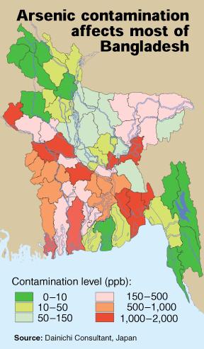
ARSENIC. 12 Arsenic contamination of groundwater in Bangladesh
 12 Arsenic contamination of groundwater in Bangladesh ARSENIC The point-source maps for arsenic show the distributions based on both rounded quartiles and on health criteria, including the WHO guideline
UNRAVELING THE HISTORY OF A LANDSCAPE: Using geomorphology, tephrochronology, and stratigraphy. Photo by: Josh Roering
 UNRAVELING THE HISTORY OF A LANDSCAPE: Using geomorphology, tephrochronology, and stratigraphy Photo by: Josh Roering Photo: Eric Bilderback Photo by: Josh Roering Goal 1. Reconstruct the paleo-landscape
Clastic Sedimentary Rocks
 Clastic Sedimentary Rocks Alessandro Grippo, Ph.D. Alternating sandstones and mudstones in Miocene turbidites Camaggiore di Firenzuola, Firenze, Italy Alessandro Grippo review Mechanical weathering creates
ES120 Sedimentology/Stratigraphy
 Midterm Exam 5/05/08 NAME: 1. List or describe 3 physical processes that contribute to the weathering of rocks (3pts). exfoliation frost wedging many others. roots, thermal expansion/contraction also credit
QUATERNARY GEOLOGICAL MAP OF THE CONTINENTAL SHELF OF VIETNAM AT THE SCALE OF 1:1,000,000
 VNU. JOURNAL OF SCIENCE, Earth sciences, T.xxIII, N 0 1, 2007 QUATERNARY GEOLOGICAL MAP OF THE CONTINENTAL SHELF OF VIETNAM AT THE SCALE OF 1:1,000,000 Tran Nghi, Dinh Xuan Thanh, Nguyen Thanh Lan, Tran
PLATEAU UPLIFT, EPEIROGENEY AND CLIMATE CHANGES The KALAHARI PLATEAU, a world class laboratory
 PLATEAU UPLIFT, EPEIROGENEY AND CLIMATE CHANGES The KALAHARI PLATEAU, a world class laboratory F. Guillocheau M. De Wit G. Dubois B. Linol F. Eckardt W. Cotterill D. Rouby C. Robin Géosciences-Rennes Université
Depositional Sequences Sequences
 Depositional Sequences Transgressive and Regressive packages can be bound by unconformities Because sediment can only be preserved during net aggradation and progradation All other times there is either
The Impact of Changing Winds on Estuarine Evolution, Copano Bay, TX
 The Impact of Changing Winds on Estuarine Evolution, Copano Bay, TX Purpose: The fulfillment of partial requirements for the Degree of Master of Science in Geology Oklahoma State University, Stillwater
Facies Reconstruction of a Late Pleistocene Cypress Forest Discovered on the Northern Gulf of Mexico Continental Shelf
 Facies Reconstruction of a Late Pleistocene Cypress Forest Discovered on the Northern Gulf of Mexico Continental Shelf Suyapa Gonzalez 1, Samuel J. Bentley, Sr. 1, Kristine L. DeLong 3, Kehui Xu 2, Jeffrey
RESULTS FROM THE TEXAS COASTAL SEDIMENT SOURCES: A GENERAL EVALUATION STUDY
 RESULTS FROM THE TEXAS COASTAL SEDIMENT SOURCES: A GENERAL EVALUATION STUDY JUAN MOYA KELSEY CALVEZ CRIS WEBER ANTHONY RISKO *KEVIN FRENZEL FREESE AND NICHOLS, INC. COASTAL AND WATERWAYS GROUP OBJECTIVES
Accommodation. Tectonics (local to regional) Subsidence Uplift
 Subsidence Uplift") Accommodation Accommodation varies over time; it is the distance between a reference horizon and the sea surface (i.e. relative sea level). The space to be filled in with sediments or water What are the
Accommodation Accommodation varies over time; it is the distance between a reference horizon and the sea surface (i.e. relative sea level). The space to be filled in with sediments or water What are the
Stratigraphic Architecture and Key Stratigraphic Surfaces Formed by Punctuated Flow Events - An Experiment on Fluviodeltaic Responses*
 Click to view movie-steady State Click to view movie-high Flow 1 Click to view movie- Low Flow 1 Click to view movie-high Flow Click to view movie-low Flow Note: If video clips do not function properly,
FLUVIAL LANDFORMS. Floodplains
 FLUVIAL LANDFORMS Floodplains fairly flat & continuous surface occupying much of a valley bottom normally underlain by unconsolidated sediments subject to periodic flooding (usually once every year or
Forward Modeling of Stratigraphic Sequences at Continental Margins
 Forward Modeling of Stratigraphic Sequences at Continental Margins Michael S. Steckler Lamont-Doherty Earth Observatory of Columbia University Palisades, NY 10964-8000 phone: (914) 365-8479 fax: (914)
4.1 Sediment accommodation space principles and controls
 58 The sedimentary record of sea-level change 4. Sediment accommodation space principles and controls Sequence stratigraphy emphasizes the importance of the space that is made available within a basin
Sediment and Sedimentary rock
 Sediment and Sedimentary rock Sediment: An accumulation of loose mineral grains, such as boulders, pebbles, sand, silt or mud, which are not cemented together. Mechanical and chemical weathering produces
Sedimentary Processes and Stratigraphic Responses in a Tectonically Driven Basin: Northern California Continental Shelf and Upper Slope
 Sedimentary Processes and Stratigraphic Responses in a Tectonically Driven Basin: Northern California Continental Shelf and Upper Slope LONG-TERM GOALS Craig S. Fulthorpe and James A. Austin, Jr. This
Final Report on Development of Deep Aquifer Database and Preliminary Deep Aquifer Map
 4 CHAPTER Final Report on Development of Deep Aquifer Database and Preliminary Deep Aquifer Map 31 Chronostragraphic Mapping 4.1 Introduction The analysis of geological logs was conducted during the project
East Asia & Southeast Asia region
 Deltas at Risk Dynamics and vulnerability of river delta system East Asia & Southeast Asia region Yoshiki Saito Geological Survey of Japan Huanghe (Yellow River) Plateau Tibetan Himalayas Old Huanghe (500
Figure EA-1: Water level of the Ganga at Harding Bridge and the Brahmaputra at Sirajgang (Bangladesh) during the 2004 monsoon. The actual dates of
 during the 2004 monsoon. The actual dates of") Figure EA-1: Water level of the Ganga at Harding Bridge and the Brahmaputra at Sirajgang (Bangladesh) during the 2004 monsoon. The actual dates of sampling are indicated by grey bars. Both rivers have
Figure EA-1: Water level of the Ganga at Harding Bridge and the Brahmaputra at Sirajgang (Bangladesh) during the 2004 monsoon. The actual dates of sampling are indicated by grey bars. Both rivers have
EARTH SURFACE PROCESSES AND SEDIMENTATION!
 Sed and Strat EARTH SURFACE PROCESSES AND SEDIMENTATION! 2/27 Lecture 7- Exposure: Weathering and the Sediment Factory 3/04 Lecture 8 - Rivers and Landscapes 3/06 Lecture 9 - Waves (not Tides) 3/11 Lecture
STRATIGRAPHIC EVOLUTION OF THE GANGES-BRAHMAPUTRA LOWER DELTA PLAIN AND ITS RELATION TO GROUNDWATER ARSENIC DISTRIBUTIONS By. Meagan G.
 STRATIGRAPHIC EVOLUTION OF THE GANGES-BRAHMAPUTRA LOWER DELTA PLAIN AND ITS RELATION TO GROUNDWATER ARSENIC DISTRIBUTIONS By Meagan G. Patrick Thesis Submitted to the Faculty of the Graduate School of
Evidence for distribution and thickness of Athens Sub-episode and older sediments in Ottawa County, Michigan
 Evidence for distribution and thickness of Athens Sub-episode and older sediments in Ottawa County, Michigan Patrick M. Colgan Department of Geology Grand Valley State University With thanks to Al Kehew
Mudanças paleo-hidrológicas, cronologia de eventos e dinâmica sedimentar no Quaternário da Bacia do Pantanal
 UNIVERSIDADE ESTADUAL PAULISTA INSTITUTO DE GEOCIÊNCIAS E CIÊNCIAS EXATAS CAMPUS DE RIO CLARO FAPESP 2014/06889-2 Mudanças paleo-hidrológicas, cronologia de eventos e dinâmica sedimentar no Quaternário
ON THE EVOLUTION OF A HOLOCENE BARRIER COAST
 ON THE EVOLUTION OF A HOLOCENE BARRIER COAST Response to sea-level change and sediment supply DANCORE Seminar 2014 COADAPT - Danish Coasts and Climate Adaptation Flooding Risk and Coastal Protection Mikkel
Character and History of the Yangtze Mud Wedge, Fujian Province
 Character and History of the Yangtze Mud Wedge, Fujian Province John D. Milliman Virginia Institute of Marine Science, College of William and Mary, Gloucester Pt, VA 23062 phone: (804) 684-7112 fax: (804)
Geography Class XI Fundamentals of Physical Geography Section A Total Periods : 140 Total Marks : 70. Periods Topic Subject Matter Geographical Skills
 Geography Class XI Fundamentals of Physical Geography Section A Total Periods : 140 Total Marks : 70 Sr. No. 01 Periods Topic Subject Matter Geographical Skills Nature and Scope Definition, nature, i)
The Palmer Hill Glacial-Marine Delta, Whitefield, Maine
 Maine Geologic Facts and Localities December, 2010, Maine 44 o 10 12.16 N, 69 o 37 18.93 W Text by Woodrow Thompson, Department of Agriculture, Conservation & Forestry 1 Introduction The most recent continental
Depositional Environment
 Depositional Environment Sedimentary depositional environment describes the combination of physical, chemical and biological processes associated with the deposition of a particular type of sediment. Types
Lecture Outlines PowerPoint. Chapter 6 Earth Science 11e Tarbuck/Lutgens
 Lecture Outlines PowerPoint Chapter 6 Earth Science 11e Tarbuck/Lutgens 2006 Pearson Prentice Hall This work is protected by United States copyright laws and is provided solely for the use of instructors
Seismic interpretation of carbonate turbidites in Central Luconia
 GeoL. Soc. MaLayaia, BuLLetin 47, December 2005; pp. 77-85 Seismic interpretation of carbonate turbidites in Central Luconia FRANcis Ho, GUENTER JAEGER AND PmT LAMBREGTS Sarawak Shell Berhad SMEP Exploration
Influence of the Major Drainages to the Mississippi River and Implications for System Level Management
 Influence of the Major Drainages to the Mississippi River and Implications for System Level Management Brian M. Vosburg Geologist Louisiana Coastal Protection and Restoration Authority brian.vosburg@la.gov
Source- to- Sink in the Stra/graphic Record
 Source- to- Sink in the Stra/graphic Record Capturing the Long-Term, Deep-Time Evolution of Sedimentary Systems Stephan A. Graham Stanford University Brian W. Romans Chevron Energy Technology Co. Jacob
Laboratory Exercise #4 Geologic Surface Processes in Dry Lands
 Page - 1 Laboratory Exercise #4 Geologic Surface Processes in Dry Lands Section A Overview of Lands with Dry Climates The definition of a dry climate is tied to an understanding of the hydrologic cycle
Decoupling Allogenic Forcing from Autogenic Processes: Experimental Stratigraphy. Wonsuck Kim
 Decoupling Allogenic Forcing from Autogenic Processes: Experimental Stratigraphy Wonsuck Kim Department of Geological Sciences and Institute for Geophysics, Jackson School of Geosciences, University of
Extra Credit Assignment (Chapters 4, 5, 6, and 10)
") GEOLOGY 306 Laboratory Instructor: TERRY J. BOROUGHS NAME: Extra Credit Assignment (Chapters 4, 5, 6, and 10) For this assignment you will require: a calculator and metric ruler. Chapter 4 Objectives:
GEOLOGY 306 Laboratory Instructor: TERRY J. BOROUGHS NAME: Extra Credit Assignment (Chapters 4, 5, 6, and 10) For this assignment you will require: a calculator and metric ruler. Chapter 4 Objectives:
Facies Analysis Of The Reservoir Rocks In The. Sylhet Trough, Bangladesh. Abstract
 Facies Analysis Of The Reservoir Rocks In The Sylhet Trough, Bangladesh Joyanta Dutta Petroleum Geoscience Program, Department of Geology, Faculty of Science, Chulalongkorn University, Bangkok 10330, Thailand
Journal of Earth Sciences and Geotechnical Engineering, vol. 4, no. 1, 2014, ISSN: (print), (online) Scienpress Ltd, 2014
, (online) Scienpress Ltd, 2014") Journal of Earth Sciences and Geotechnical Engineering, vol. 4, no. 1, 2014, 17-24 ISSN: 1792-9040 (print), 1792-9660 (online) Scienpress Ltd, 2014 Reconstruction of Relative Tectonic Movements Using Transgressive
Journal of Earth Sciences and Geotechnical Engineering, vol. 4, no. 1, 2014, 17-24 ISSN: 1792-9040 (print), 1792-9660 (online) Scienpress Ltd, 2014 Reconstruction of Relative Tectonic Movements Using Transgressive
Sediment and sedimentary rocks Sediment
 Sediment and sedimentary rocks Sediment From sediments to sedimentary rocks (transportation, deposition, preservation and lithification) Types of sedimentary rocks (clastic, chemical and organic) Sedimentary
Paper presented in the Annual Meeting of Association of American Geographers, Las Vegas, USA, March 2009 ABSTRACT
 Paper presented in the Annual Meeting of Association of American Geographers, Las Vegas, USA, March 2009 ABSTRACT CHANGING GEOMORPHOLOGY OF THE KOSI RIVER SYSTEM IN THE INDIAN SUBCONTINENT Nupur Bose,
STREAM SYSTEMS and FLOODS
 STREAM SYSTEMS and FLOODS The Hydrologic Cycle Precipitation Evaporation Infiltration Runoff Transpiration Earth s Water and the Hydrologic Cycle The Hydrologic Cycle The Hydrologic Cycle Oceans not filling
Precipitation Evaporation Infiltration Earth s Water and the Hydrologic Cycle. Runoff Transpiration
 STREAM SYSTEMS and FLOODS The Hydrologic Cycle Precipitation Evaporation Infiltration Earth s Water and the Hydrologic Cycle Runoff Transpiration The Hydrologic Cycle The Hydrologic Cycle Oceans not filling
Dynamics and Evolution of Tributary Alluvial Fans in the Grand Canyon below Glen Canyon Dam Alex Morelan
 Dynamics and Evolution of Tributary Alluvial Fans in the Grand Canyon below Glen Canyon Dam Alex Morelan Abstract/ Introduction: Tributary alluvial fans along the Grand Canyon are key to both natural and
Rockall Plateau. OCN 201: Shelf Sediments
 Rockall Plateau OCN 201: Shelf Sediments Classification by Size Classification by Mode of Formation Detrital sediments Transported and deposited as particles Derived from weathering of pre-existing rocks
2013 SCEC Annual Report
 2013 SCEC Annual Report Collaborative research: Documentation of Tsunami Deposits in the Carpinteria Estuary: A signal of Great Earthquakes on the Pitas Point Thrust L. Reynolds, A. Simms, T.K. Rockwell,
Controls on clastic systems in the Angoche basin, Mozambique: tectonics, contourites and petroleum systems
 P2-2-13 Controls on clastic systems in the Angoche basin, Mozambique: tectonics, contourites and petroleum systems Eva Hollebeek, Olivia Osicki, Duplo Kornpihl Schlumberger, London, UK Introduction Offshore
QUATERNARY AND GLACIAL GEOLOGY
 QUATERNARY AND GLACIAL GEOLOGY JURGEN EHLERS Geologisches Landesamt, Germany Translated from Allgemeine und historische Quartdrgeologie English version by Philip L. Gibbard JOHN WILEY & SONS Chichester
The Building of the NYC Region
 The Building of the NYC Region Definitions Fall Line marks the area where an upland region (continental bedrock) and a coastal plain meet Piedmont the plateau region of the eastern United States which
Lecture 19: Fluvial Facies
 GEOL 440 Sedimentology and stratigraphy: processes, environments and deposits Lecture 19: Fluvial Facies Aims Examine controls on alluvial channel pattern List the types of channel pattern Examine meandering
Main issues of Deltas
 Global sediment supply to coastal seas and oceans; location of major river deltas RIVER DELTAS Depositional processes - Course Coastal Morphodynamics GEO3-436; lecture 4 Nile Delta, Egypt Solo Delta, Java,
Diagnostic Geomorphic Methods for Understanding Future Behavior of Lake Superior Streams What Have We Learned in Two Decades?
 Diagnostic Geomorphic Methods for Understanding Future Behavior of Lake Superior Streams What Have We Learned in Two Decades? Faith Fitzpatrick USGS WI Water Science Center, Middleton, WI fafitzpa@usgs.gov
The Late Quaternary Rio Grande Delta A Distinctive, Underappreciated Geologic System
 The Late Quaternary Rio Grande Delta A Distinctive, Underappreciated Geologic System Thomas E. Ewing 1 and Juan L. Gonzalez 2 1 Frontera Exploration Consultants, 19240 Redland Rd., Ste. 250, San Antonio,
Geophysics the use of geology, laboratory & field experiments, mathematics, and instruments to study: Earthquakes and Volcanoes seismometers,
 Geophysics the use of geology, laboratory & field experiments, mathematics, and instruments to study: Earthquakes and Volcanoes seismometers, tiltmeters, EDM, remote sensing, Energy: oil, gas, hydrothermal
Persistent effects of the Yellow River on the Chinese marginal seas began at least. ~880 ka ago
 Persistent effects of the Yellow River on the Chinese marginal seas began at least ~880 ka ago Zhengquan Yao, Xuefa Shi, Shuqing Qiao, Qingsong Liu, Selvaraj Kandasamy, Jianxing Liu, Yanguang Liu, Jihua
Erlangga Septama 1 and Samuel J. Bentley 1. Search and Discovery Article #50283 (2010) Posted August 10, 2010
 Posted August 10, 2010") Late Quaternary Deepwater Fan Depositional Cycles in the Gulf of Papua: Linking Sources, Dynamic Sedimentation Processes, and Depositional Architecture* Erlangga Septama 1 and Samuel J. Bentley 1 Search
Late Quaternary Deepwater Fan Depositional Cycles in the Gulf of Papua: Linking Sources, Dynamic Sedimentation Processes, and Depositional Architecture* Erlangga Septama 1 and Samuel J. Bentley 1 Search
Fluid-Mud Deposits of the Lower Jurassic Tilje Formation, Offshore Mid-Norway By Aitor A. Ichaso and Robert W. Dalrymple 1
 Fluid-Mud Deposits of the Lower Jurassic Tilje Formation, Offshore Mid-Norway By Aitor A. Ichaso and Robert W. Dalrymple 1 Search and Discovery Article #50107 (2008) Posted August 10, 2008 *Adapted from
The Ocean Floor Chapter 14. Essentials of Geology, 8e. Stan Hatfield and Ken Pinzke Southwestern Illinois College
 The Ocean Floor Chapter 14 Essentials of Geology, 8e Stan Hatfield and Ken Pinzke Southwestern Illinois College The vast world ocean Earth is often referred to as the water planet 71% of Earth s surface
Chapter 4 Implications of paleoceanography and paleoclimate
 Age ka / Chapter 4 Implications of paleoceanography and paleoclimate 4.1 Paleoclimate expression 4.2 Implications of paleocirculation and tectonics 4.3 Paleoenvironmental reconstruction MD05-2901 (Liu
Stratigraphic modelling using CHILD
 5 Stratigraphic modelling using CHILD 5.1 Triangular irregular network Surface process models are widely used in geomorphology and geology, and the developments in the field follow each other rapidly.
Final Exam. Running Water Erosion and Deposition. Willamette Discharge. Running Water
 Final Exam Running Water Erosion and Deposition Earth Science Chapter 5 Pages 120-135 Scheduled for 8 AM, March 21, 2006 Bring A scantron form A calculator Your 3 x 5 paper card of formulas Review questions
Holocene Carbonate-Siliciclastic Shoreline and Ravinement Stratigraphy of the Belize Lagoon: a Mixed-System Model
 Holocene CarbonateSiliciclastic Shoreline and Ravinement Stratigraphy of the Belize Lagoon: a MixedSystem Model DONALD F. MCNEILL AND CLINTON A. COWAN Key findings o Mixedsystem facies heterogeneity during
Offshore Evidence for Uplift Rate Boundaries. Hans AbramsonWard Diablo Canyon SSHAC SSC Workshop 2 November 7, 2012
 Offshore Evidence for Uplift Rate Boundaries Hans AbramsonWard Diablo Canyon SSHAC SSC Workshop 2 November 7, 2012 Questions asked by the TI team Discuss your ability to distinguish and correlate offshore
Lecture Outlines PowerPoint. Chapter 13 Earth Science 11e Tarbuck/Lutgens
 Lecture Outlines PowerPoint Chapter 13 Earth Science 11e Tarbuck/Lutgens 2006 Pearson Prentice Hall This work is protected by United States copyright laws and is provided solely for the use of instructors
Landscape Development
 Landscape Development Slopes Dominate Natural Landscapes Created by the interplay of tectonic and igneous activity and gradation Deformation and uplift Volcanic activity Agents of gradation Mass wasting
GEOL 440 Sedimentology and stratigraphy: processes, environments and deposits Lectures 16 & 17: Deltaic Facies
 GEOL 440 Sedimentology and stratigraphy: processes, environments and deposits Lectures 16 & 17: Deltaic Facies What controls morphology and facies of the Nile Delta? Basic processes Classification Facies
Application of Predictive Modeling to the Lower Cretaceous Sedimentary Sequences of the Central Scotian Basin
 Application of Predictive Modeling to the Lower Cretaceous Sedimentary Sequences of the Central Scotian Basin Christopher R. Sangster 1, Nicolas Hawie 2, Georgia Pe-Piper 1, Francky Saint-Ange 2, David
Overview of fluvial and geotechnical processes for TMDL assessment
 Overview of fluvial and geotechnical processes for TMDL assessment Christian F Lenhart, Assistant Prof, MSU Research Assoc., U of M Biosystems Engineering Fluvial processes in a glaciated landscape Martin
Paradoxes of Fluvial Evolution in Young Orogenic Systems
 Journal of Indian Geomorphology Volume 5, 2017 ISSN 2320-0731 Indian Institute of Geomorphologists (IGI) Paradoxes of Fluvial Evolution in Young Orogenic Systems Leszek Starkel Department of Geoenvironmental
Land subsidence due to groundwater withdrawal in Hanoi, Vietnam
 Land Subsidence (Proceedings of the Fifth International Symposium on Land Subsidence, The Hague, October 1995). 1AHS Publ. no. 234, 1995. 55 Land subsidence due to groundwater withdrawal in Hanoi, Vietnam
L7/ Historical Perspec=ve, Deltas
 Colin Woodroffe (2002) Coasts: Form, Process and Evolu=on, Outline of Chapter 7: L7/1 L7/2 7.1. Historical Perspec=ve, 7.1.1. Deltas Herodotus (450, B.C.) delta = Shape of Nile River Delta = Δ Gilbert