Facies Reconstruction of a Late Pleistocene Cypress Forest Discovered on the Northern Gulf of Mexico Continental Shelf
|
|
|
- Mercy Park
- 5 years ago
- Views:
Transcription
1 Facies Reconstruction of a Late Pleistocene Cypress Forest Discovered on the Northern Gulf of Mexico Continental Shelf Suyapa Gonzalez 1, Samuel J. Bentley, Sr. 1, Kristine L. DeLong 3, Kehui Xu 2, Jeffrey Obelcz 2, Jonathan Truong 1, Grant L. Harley 4, Carl A. Reese 4, and Alicia Caporaso 5 1 Coastal Studies Institute and Department of Geology and Geophysics, Louisiana State University, 331 & E235 Howe-Russell Geoscience Complex, Baton Rouge, Louisiana Coastal Studies Institute and Department of Oceanography and Coastal Sciences, Louisiana State University, 2165 Energy, Coast & Environment Bldg., Baton Rouge, Louisiana Department of Geography and Anthropology, Louisiana State University, 227 Howe-Russell Geoscience Complex, Baton Rouge, Louisiana Department of Geography and Geology, University of Southern Mississippi, 118 College Dr., Box 5051, Hattiesburg, Mississippi Bureau of Ocean Energy Management, 1201 Elmwood Park Blvd., New Orleans, Louisiana GCAGS Explore & Discover Article #00196 * Posted October 30, * Article based on a full paper published in the GCAGS Transactions (see footnote reference below), which is available as part of the entire 2017 GCAGS Transactions volume via the GCAGS Bookstore at the Bureau of Economic Geology ( or as an individual document via AAPG Datapages, Inc. ( and delivered as an oral presentation at the 67th Annual GCAGS Convention and 64th Annual GCSSEPM Meeting in San Antonio, Texas, November 1 3, ABSTRACT A previously buried bald cypress forest (Taxodium distichum) was discovered on the continental shelf seafloor, offshore of Orange Beach, Alabama, USA, in ~20 m water depth. The forest was likely buried in the late Pleistocene, possibly exhumed by Hurricane Ivan in 2004, and is now exposed as stumps in life position. In August 2015 and July 2016, submersible vibracores and geophysical data were collected to investigate local stratigraphy and mode of forest preservation. This study focuses on analysis of the longest and most stratigraphically complete vibracore, DF 1 (4.78 m). This core revealed, from top to bottom, a surface of Holocene transgressive sands, underlain by interbedded sand and mud (potentially Holocene or Pleistocene), overlying a swamp or delta plain facies (likely Pleistocene) containing woody debris and mud that has been provisionally dated using radiocarbon to ca ka. One core collected in 2016 revealed a Pleistocene paleosol beneath Holocene sands in a nearby trough. We hypothesize that floodplain aggradation in the area was a key factor that might have allowed forest preservation. A sea-level rise pulse of m occurred ca. 40 ka that could have produced widespread floodplain aggradation, likely burying the swamp and forest sediments. During the subsequent glacial lowstand, sediments that comprise the floodplain were eroded and paleosols were formed in other nearby areas. It is hypothesized that some swamp sediments located in paleo-topographic lows might have Originally published as: Gonzalez, S., S. J. Bentley, Sr., K. L. DeLong, K. Xu, J. Obelcz, J. Truong, G. L. Harley, C. A. Reese, and A. Caporaso, 2017, Facies reconstruction of a late Pleistocene cypress forest discovered on the northern Gulf of Mexico continental shelf: Gulf Coast Association of Geological Societies Transactions, v. 67, p
2 Gonzalez et al. been preserved and buried due to the deep coverage of the eastern-trending channel infill sediments. Coastal wave erosion during transgression likely eroded high ground but enough sediment remained to keep the cypress forest blanketed and therefore allowed preservation of stumps and woody debris. 2
3 1
4 2


5 3
6 The forest was likely buried in the late Pleistocene and possibly exhumed by Hurricane Ivan in
")
.")
7 Map of study area showing approximate location of the ancient forest (blue box) within the context of the northern Gulf of Mexico coast. Study Area: Northeastern Gulf of Mexico ~15 km south of Gulf Shores, Alabama meters below sea level Seabed: MAFLA (Mississippi-Alabama-Florida) sand sheet Subdivided into two subprovinces: the Mobile and the Apalachicola Northwest-southeast trending ridges and troughs From recent geophysical surveys and seafloor mapping, various locations of drowned cypress trees have been identified (this study). Low microtidal range and a low sediment-supply regime 5

8 They are not found in brackish or saline waters. Like any other type of wetlands in the region, bald cypress forests are also subject to the effects of regional sea level rise and increase in flooding and salinity. During the past decade or so, numerous examples of tree stumps in life position have been identified exposed on the continental shelf seabed, south of the Alabama shoreline. Their depth and location initially suggested their ages to be late Pleistocene to early Holocene saline waters of up to 0.89% salinity (Hook reference) 6
9 The location of these pristine tree stumps, approximately 15 km offshore the Gulf Shores, Alabama, and 20 meters below present day sea level, can give valuable insight to paleoenvironmental conditions, such as sea level variations, climate, and position of ancient shoreline. 1. A detailed description of the different sedimentary facies found in the study site will provide better insight to how, when, and why the tree stumps were preserved. 2. This will contribute greatly to the reconstruction of the geological history of the area. 3. This time frame is not well documented in the region, because many of the sedimentary records have been eroded and in many cases drowned under rising seas. 7


10 Photographs of bald cypress stumps at the study site. Images by: Kristine DeLong 8


11 Cypress woods samples recovered from the study site. Images by: Kristine DeLong 9
12 1. Sea level rise in the area is directly associated with changes in global eustatic sea level. Consequently, this results in changes in shoreline position and therefore regional stratigraphy 4. This slowdown in rate of sea level rise during this time period allowed for the development of coastal landforms in the area. Furthermore, shoreline position has been relatively stable (Donoghue, 2011). 10
13 11

14 Submersible vibracorer used for this study to collect cores up to 5 meters in length. Image by: Kristine DeLong 12
15 13


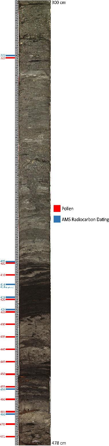
16 DF-1 Sediment Samples Radiocarbon Results Sample Type Sample Name 14 C age ± Cal BP age Cal BP range Sediment 322 cm DF1-322 ड़ज़ज़ Sediment 405 cm DF ढ़ढ़ ज़ Sediment 414 cm DF Sediment 414 cm DF ड़ज़ज़ Sediment 419 cm DF1-419 ड़ज़ज़ Sediment 424 cm DF1-424 ड़ज़ज़ Sediment 456 cm DF1-456 ड़ज़ज़ Sediment 466 cm DF1-466 ड़ज़ज़ Plant material that was 14 C dated Because these radiocarbon ages are near the upper bounds of reliable detection, ca. 40 ky BP, other absolute dating methods are currently under way, such as optically stimulated luminescence OSL). 14

17 Bathymetric map of study site showing DF-1 core location, collected in August,

18 DF-1 comprehensive graph showing % organic content, mean grain size, and gamma density vs. depth profile. 16

19 Int. Sand and Mud Int. Mud and Peat Comprehensive figure of core DF-1 showing gamma density, facies classification and radiocarbon date. 17
20 Global sea level variations since 60,000 years ago. Modified from Waelbroeck et al., (2002). Sea level near that time was in the range of -50 to -90 m below present sea level and regional topographic relief was relatively low. However, this relationship indicates that the forest grew at an elevation above and possibly distant from sea level and the shoreline, respectively. Based on this assumption, we can identify approximate time frames when the forest may have grown, by studying sea-level curves in Figure above. Age constraints on the mud and peat unit in core DF-1, and the likelihood that this unit immediately overlies the buried stumps, suggests that the forest was buried by aggrading swamp and floodplain in deposits before ka. These deposits were buried and protected from erosion during a period of perhaps 30,000 years of regression, transgression, and likely extensive subaerial exposure. For this to happen, it is likely that these deposits were originally buried by a substantial thickness of sediments, which were mostly, but not entirely eroded during Pleistocene exposure and Holocene transgression. One potential process that could have produced such sediment burial is floodplain aggradation. 18
21 may have produced local floodplain aggradation, burying the forest and inland floodplain. Global sea level variations since 60,000 years ago. Modified from Waelbroeck et al., (2002). We hypothesize that floodplain aggradation in the area is a key factor that might have allowed for forest preservation A temporary sea-level rise of m occurred ca. 40 ka, which may have produced local floodplain aggradation that might have buried the swamp and forest sediments. Such rapid aggradation has been observed many km inland in other coastal-plain alluvial valleys (other studies) During lowstands, sea level falls and the sediments that comprise the floodplain are eroded. Subsequently, paleosols were formed in other nearby areas. 19

22 Time structure map of MIS (Marine Isotope Stage) 2 sequence boundary. Redbox shows approximate location of study site. Modified from Bartek et al., (2004). With bifurcation of the Mobile-Tensaw River system during the MIS 2, two incised valleys were reoccupied south of Mobile Bay. One eastern trending incised valley and one western trending incised valley were identified by Bartek et al., (2004). Sea-level-rise patterns in the area during the Holocene are interpreted to have led to transgression of the depositional environments associated with the incised valleys, therefore changing the position of the coastline. We propose that swamp sediments such as in DF-1, located in topographic lows, might have been preserved and buried by fluvial/floodplain sediment accumulation. Finally, as sea level rose and transgression occurred, sediments within the incised valleys were first eroded by transgression of the coastline and associated wave energy, and later covered by Holocene shelf sands as sea level rose, thus causing the coastline position to retreat. Coastal wave erosion during transgression likely eroded high ground but enough sediment remained to keep the cypress forest blanketed, therefore fortuitously favoring preservation. 20

23 If hypothesis is CORRECT: because the depth range of such forest preservation would be caused by the regional impact of sea-level rise and associated flood plain transgression, similar to our study area, forming a sort of bathtub ring around the Gulf of Mexico at common age and depth Also, these sites should be concentrated offshore of modern river systems that would have incised the shelf at lower sea levels, and deposited sediments during the phase of floodplain aggradation around 40 ky ago that likely preserved our drowned forest. 21
24 microfossil assemblage will help characterize changes in depositional environment and ravinement surfaces between facies. 22


25 23
26 24
27 25


28 0 cm 263 cm 262 cm 478 cm 26
Sedimentation Dynamics and Stratigraphy of the Middle Breton Sound Estuary, Southeastern Louisiana: Spatiotemporal Evidence for Subdeltaic Evolution
 Sedimentation Dynamics and Stratigraphy of the Middle Breton Sound Estuary, Southeastern Louisiana: Spatiotemporal Evidence for Subdeltaic Evolution Edwin J. Bomer IV 1, Samuel J. Bentley 1,2, Kehui Xu
Holocene Lower Mississippi River Avulsions: Autogenic Versus Allogenic Forcing*
 Holocene Lower Mississippi River Avulsions: Autogenic Versus Allogenic Forcing* Eric Prokocki 1,2 Search and Discovery Article #50330 (2010) Posted October 14, 2010 *Adapted from oral presentation at AAPG
Developed in Consultation with Florida Educators
 Developed in Consultation with Florida Educators Table of Contents Next Generation Sunshine State Standards Correlation Chart... 7 Benchmarks Chapter 1 The Practice of Science...................... 11
The Late Quaternary Rio Grande Delta A Distinctive, Underappreciated Geologic System
 The Late Quaternary Rio Grande Delta A Distinctive, Underappreciated Geologic System Thomas E. Ewing 1 and Juan L. Gonzalez 2 1 Frontera Exploration Consultants, 19240 Redland Rd., Ste. 250, San Antonio,
ON THE EVOLUTION OF A HOLOCENE BARRIER COAST
 ON THE EVOLUTION OF A HOLOCENE BARRIER COAST Response to sea-level change and sediment supply DANCORE Seminar 2014 COADAPT - Danish Coasts and Climate Adaptation Flooding Risk and Coastal Protection Mikkel
Sedimentology, Petrography, and Mineralogy of the Tallahatta Formation near the City of Meridian, Mississippi
 Sedimentology, Petrography, and Mineralogy of the Tallahatta Formation near the City of Meridian, Mississippi Kiana McFadden and Ezat Heydari Department of Physics, Atmospheric Sciences, and Geoscience,
Last Time. Submarine Canyons and Fans. Turbidites. MAS 603: Geological Oceanography. Lecture 16: Greenhouse vs. Icehouse Earths
 UNIVERSITY OF SOUTH ALABAMA Last Time MAS 603: Geological Oceanography Lecture 16: Greenhouse vs. Icehouse Earths Submarine Fans Definition and morphology Transport mechanisms (density currents) Submarine
Structural Styles and Geotectonic Elements in Northwestern Mississippi: Interpreted from Gravity, Magnetic, and Proprietary 2D Seismic Data
 Structural Styles and Geotectonic Elements in Northwestern Mississippi: Interpreted from Gravity, Magnetic, and Proprietary 2D Seismic Data Nick Loundagin 1 and Gary L. Kinsland 2 1 6573 W. Euclid Pl.,
Moosehead Lake and the Tale of Two Rivers
 Maine Geologic Facts and Localities June, 2005 45 o 53 5.09 N, 69 o 42 14.54 W Text by Kelley, A.R.; Kelley, J.T.; Belknap, D.F.; and Gontz, A.M. Department of Earth Sciences, University of Maine, Orono,
EARTH SURFACE PROCESSES AND SEDIMENTATION!
 Sed and Strat EARTH SURFACE PROCESSES AND SEDIMENTATION! 2/27 Lecture 7- Exposure: Weathering and the Sediment Factory 3/04 Lecture 8 - Rivers and Landscapes 3/06 Lecture 9 - Waves (not Tides) 3/11 Lecture
Lab 12 Coastal Geology
 Lab 12 Coastal Geology I. Fluvial Systems Hydrologic Cycle Runoff that flows into rivers = precipitation (rain and snowmelt) [infiltration (loss to groundwater) + evaporation (loss to atmosphere) + transpiration
MISSISSIPPI RIVER DELTA OVERVIEW
 MISSISSIPPI RIVER DELTA OVERVIEW Science and Engineering Special Team Conference Louisiana State University October 9, 2012 Introduction Basics of the Mississippi Delta Natural and Human-Induced Land Loss
Paleo Lab #4 - Sedimentary Environments
 Paleo Lab #4 - Sedimentary Environments page - 1. CHARACTERISTICS OF SEDIMENT Grain size and grain shape: The sizes and shapes of sedimentary particles (grains) are modified considerably during their transportation
The Impact of Changing Winds on Estuarine Evolution, Copano Bay, TX
 The Impact of Changing Winds on Estuarine Evolution, Copano Bay, TX Purpose: The fulfillment of partial requirements for the Degree of Master of Science in Geology Oklahoma State University, Stillwater
Name: Date: Class: Louisiana: Our History, Our Home Chapter 1: Louisiana s Geography - Section 2: Natural Regions Guided Reading
 Instructions: Read the section and complete each item with words from the passages in this section. 1. The diversity of Louisiana s can surprise residents and visitors alike. 2. Physical geography is concerned
UNRAVELING THE HISTORY OF A LANDSCAPE: Using geomorphology, tephrochronology, and stratigraphy. Photo by: Josh Roering
 UNRAVELING THE HISTORY OF A LANDSCAPE: Using geomorphology, tephrochronology, and stratigraphy Photo by: Josh Roering Photo: Eric Bilderback Photo by: Josh Roering Goal 1. Reconstruct the paleo-landscape
The Coast: Beaches and Shoreline Processes
 1 2 3 4 5 6 7 8 9 The Coast: es and Shoreline Processes Trujillo & Thurman, Chapter 10 Oceanography 101 Chapter Objectives Recognize the various landforms characteristic of beaches and coastal regions.
South Texas Holocene climate reconstructed from O18 measurements of ostracods and
 Daniel Livsey received his undergraduate degree from Oklahoma State University and is now working on his dissertation at the University of California, Santa Barbara. South Texas Holocene climate reconstructed
Kristy Milliken, Rice University
 2005 GCSSEPM Foundation Ed Picou Fellowship Grant for Graduate Studies in the Earth Sciences Recipient Kristy Milliken, Rice University Controls on the Transgressive facies of coastal plain incised valley
CHAPTER 1 INTRODUCTION
 1 CHAPTER 1 INTRODUCTION 1.1 GENERAL Washover sandsheets are often found in low-lying coastal embayment s (Sedgwick and Davis 2003). Washover deposition of marine sand is usually attributed to storm activity
The Coast: Beaches and Shoreline Processes Trujillo & Thurman, Chapter 10
 The Coast: es and Shoreline Processes Trujillo & Thurman, Chapter 10 Oceanography 101 Chapter Objectives Recognize the various landforms characteristic of beaches and coastal regions. Identify seasonal
Reading Material. See class website. Sediments, from Oceanography M.G. Gross, Prentice-Hall
 Reading Material See class website Sediments, from Oceanography M.G. Gross, Prentice-Hall Materials filling ocean basins Dissolved chemicals especially from rivers and mid-ocean ridges (volcanic eruptions)
Name: Which rock layers appear to be most resistant to weathering? A) A, C, and E B) B and D
 A, C, and E B) B and D") Name: 1) The formation of soil is primarily the result of A) stream deposition and runoff B) precipitation and wind erosion C) stream erosion and mass movement D) weathering and biological activity 2)
Name: 1) The formation of soil is primarily the result of A) stream deposition and runoff B) precipitation and wind erosion C) stream erosion and mass movement D) weathering and biological activity 2)
Bulletin of Earth Sciences of Thailand
 Depositional Environments and Stratigraphic Development of the Grand Taman Sari Circuit Outcrop: an Analogue for Transgressive Mahakam Delta Successions Ridha Santika Riadi Petroleum Geoscience Program,
The 1700/01/26 Cascadia subduction zone Earthquake and Tsunami
 Jason R. Patton GEO 142 1/13/15 Abstract: Cascadia subduction zone earthquakes (CSZ) can generate strong ground shaking and deadly tsunamis. Geologists used sediment cores and stream bank exposures to
Rockall Plateau. OCN 201: Shelf Sediments
 Rockall Plateau OCN 201: Shelf Sediments Classification by Size Classification by Mode of Formation Detrital sediments Transported and deposited as particles Derived from weathering of pre-existing rocks
Accommodation. Tectonics (local to regional) Subsidence Uplift
 Subsidence Uplift") Accommodation Accommodation varies over time; it is the distance between a reference horizon and the sea surface (i.e. relative sea level). The space to be filled in with sediments or water What are the
Accommodation Accommodation varies over time; it is the distance between a reference horizon and the sea surface (i.e. relative sea level). The space to be filled in with sediments or water What are the
2.2.7 Backbarrier flats
 FIGURE 24. VERTICAL PHOTOGRAPH SHOWING THE DEVELOPMENT OF SMALL PARABOLIC DUNES FROM BLOWOUTS IN A LARGE RELICT FOREDUNE NORTHWEST OF HUNTER'S CREEK. PHOTOGRAPH COURTESY OF CAR'T'ER HOLT HARVEY FORESTS
Long-Term Patterns of Coastal Response to Changing Land Use and Climate: Examples from the Atlantic and Gulf Coastal Plains
 Long-Term Patterns of Coastal Response to Changing Land Use and Climate: Examples from the Atlantic and Gulf Coastal Plains Debra Willard, Christopher Bernhardt, and Miriam Jones U.S. Geological Survey,
Holocene evolution of Dahab coastline Gulf of Aqaba, Sinai Peninsula, Egypt 1
 Holocene evolution of Dahab coastline Gulf of Aqaba, Sinai Peninsula, Egypt 1 Magdy Torab* 2 * Prof. of Geomorphology, Department of Geography, Damanhour University, Egypt 3 E-mail: magdytorab@hotmail.com.
Monitoring Hurricane Rita Inland Storm Surge
 Monitoring Hurricane Rita Inland Storm Surge By Benton D. McGee, Roland W. Tollett, and Burl B. Goree Pressure transducers (sensors) are accurate, reliable, and cost-effective tools to measure and record
Regional-scale understanding of the geologic character and sand resources of the Atlantic inner continental shelf, Maine to Virginia
 Regional-scale understanding of the geologic character and sand resources of the Atlantic inner continental shelf, Maine to Virginia Workshop on Dredging, Beach Nourishment and Bird Conservation Atlantic
The Overall Objectives of Proposed Study
 Eric Prokocki is currently working on a Ph.D. degree at The University of Illinois. His advisor is Dr. Gary Proctor. His research project is related to Holocene evolution and avulsion dynamics of the lower
PROMISED LAND STATE PARK PIKE COUNTY ANCIENT RIVERS AND AGES OF ICE
 PENNSYLVANIA TRAIL OF GEOLOGY PARK GUIDE 18 PROMISED LAND STATE PARK PIKE COUNTY ANCIENT RIVERS AND AGES OF ICE Promised Land State Park is located on a broad upland surface known as the Pocono Plateau.
2 Georgia: Its Heritage and Its Promise
 TERMS region, erosion, fault, elevation, Fall Line, aquifer, marsh, climate, weather, precipitation, drought, tornado, hurricane, wetland, estuary, barrier island, swamp PLACES Appalachian Mountains, Appalachian
Unchain the River and Allow it to Build a Delta
 Unchain the River and Allow it to Build a Delta Harley S. Winer Atkins Harley.Winer@atkinsglobal.com Mississippi River Drainage Basin Basin Facts Drains 41% of continental U.S. Includes 31 states & 2 Canadian
Shallow marine facies. Outline 13: The Paleozoic World. Shallow marine and terrestrial facies
 Outline 13: The Paleozoic World Shallow marine and terrestrial facies Shallow marine facies Sea level was much higher than today during much of the Paleozoic. Shallow epicontinental seas flooded continental
II Why study coastal landforms?
 COASTAL LANDFORMS (32) I Main topics A Why study coastal landforms? B Sediment budget and system response C Coastal landforms 3/26/15 GG454 1 II Why study coastal landforms? A Dynamic systems B Reflect
Case Study of the Structural and Depositional-Evolution Interpretation from Seismic Data*
 Case Study of the Structural and Depositional-Evolution Interpretation from Seismic Data* Yun Ling 1, Xiangyu Guo 1, Jixiang Lin 1, and Desheng Sun 1 Search and Discovery Article #20143 (2012) Posted April
Sequence Stratigraphy as a tool for water resources management in alluvial coastal aquifers: application to the Llobregat delta (Barcelona, Spain)
") Sequence Stratigraphy as a tool for water resources management in alluvial coastal aquifers: application to the Llobregat delta (Barcelona, Spain) Desiré Gàmez Torrent December 2007 CHAPTER 1: Introduction
Sequence Stratigraphy as a tool for water resources management in alluvial coastal aquifers: application to the Llobregat delta (Barcelona, Spain) Desiré Gàmez Torrent December 2007 CHAPTER 1: Introduction
Lake Levels and Climate Change in Maine and Eastern North America during the last 12,000 years
 Maine Geologic Facts and Localities December, 2000 Lake Levels and Climate Change in Maine and Eastern North America during the last 12,000 years Text by Robert A. Johnston, Department of Agriculture,
Holocene Carbonate-Siliciclastic Shoreline and Ravinement Stratigraphy of the Belize Lagoon: a Mixed-System Model
 Holocene CarbonateSiliciclastic Shoreline and Ravinement Stratigraphy of the Belize Lagoon: a MixedSystem Model DONALD F. MCNEILL AND CLINTON A. COWAN Key findings o Mixedsystem facies heterogeneity during
Search and Discovery Article #40536 (2010) Posted June 21, 2010
 Posted June 21, 2010") Modern Examples of Mass Transport Complexes, Debrite and Turbidite Associations: Geometry, Stratigraphic Relationships and Implications for Hydrocarbon Trap Development* Fabiano Gamberi 1, Marzia Rovere
Modern Examples of Mass Transport Complexes, Debrite and Turbidite Associations: Geometry, Stratigraphic Relationships and Implications for Hydrocarbon Trap Development* Fabiano Gamberi 1, Marzia Rovere
4. The map below shows a meandering stream. Points A, B, C, and D represent locations along the stream bottom.
 1. Sediment is deposited as a river enters a lake because the A) velocity of the river decreases B) force of gravity decreases C) volume of water increases D) slope of the river increases 2. Which diagram
Objectives: Define Relative Age, Absolute Age
 S6E5. Students will investigate the scientific view of how the earth s surface is formed. c. Classify rocks by their process of formation. g. Describe how fossils show evidence of the changing surface
LATE QUATERNARY STRATIGRAPHIC EVOLUTION OF THE ALABAMA AND WEST FLORIDA OUTER CONTINENTAL SHELF
 LATE QUATERNARY STRATIGRAPHIC EVOLUTION, ALABAMA AND WEST FLORIDA OUTER CONTINENTAL SHELF Copyright 2012, Society for Sedimentary Geology (SEPM) LATE QUATERNARY STRATIGRAPHIC EVOLUTION OF THE ALABAMA AND
DATA REPOSITORY MATERIAL: PALEOCHANNEL GROUP MAPPING DESCRIPTIONS
 Data Repository item 2695 DATA REPOSITORY MATERIAL: PALEOCHANNEL GROUP MAPPING DESCRIPTIONS Groups 1 (North Myrtle Beach) and 2 (Atlantic Beach) Channel Groups 1 (North Myrtle Beach) and 2 (Atlantic Beach)
Hurricanes and Storm Surge : Before coming to lab, visit the following web site:
 Geol 108 Lab #7 Week of October 15-19, 2012 Coastal Studies Hurricanes and Storm Surge : Before coming to lab, visit the following web site: http://www.usatoday.com/graphics/weather/gra/gsurge/flash.htm
RESULTS FROM THE TEXAS COASTAL SEDIMENT SOURCES: A GENERAL EVALUATION STUDY
 RESULTS FROM THE TEXAS COASTAL SEDIMENT SOURCES: A GENERAL EVALUATION STUDY JUAN MOYA KELSEY CALVEZ CRIS WEBER ANTHONY RISKO *KEVIN FRENZEL FREESE AND NICHOLS, INC. COASTAL AND WATERWAYS GROUP OBJECTIVES
Mammoth Cave National Park, Kentucky
 Mammoth Cave National Park, Kentucky Objectives of Today s Lecture Refresher on Sedimentary Depositional Systems and Rock Classifications Transgressive and Regressive Marine Environments Carbonate Depositional
Forecast of Nearshore Wave Parameters Using MIKE-21 Spectral Wave Model
 Forecast of Nearshore Wave Parameters Using MIKE-21 Spectral Wave Model Felix Jose 1 and Gregory W. Stone 2 1 Coastal Studies Institute, Louisiana State University, Baton Rouge, LA 70803 2 Coastal Studies
Landscape evolution. An Anthropic landscape is the landscape modified by humans for their activities and life
 Landforms Landscape evolution A Natural landscape is the original landscape that exists before it is acted upon by human culture. An Anthropic landscape is the landscape modified by humans for their activities
Cattaraugus Creek: A Story of Flowing Water and the Geology of the Channel It Flows Through Presentation to West Valley Citizen Task Force 4/27/16
 Cattaraugus Creek: A Story of Flowing Water and the Geology of the Channel It Flows Through Presentation to West Valley Citizen Task Force 4/27/16 Raymond C. Vaughan, Ph.D. What happens if you drop a
COASTAL QUATERNARY GEOLOGY MAPPING FOR NSW: EXAMPLES AND APPLICATIONS
 COASTAL QUATERNARY GEOLOGY MAPPING FOR NSW: EXAMPLES AND APPLICATIONS A Troedson Geological Survey of New South Wales Abstract Detailed geological mapping of the coastal plains of regional NSW was undertaken
Osareni C. Ogiesoba and Angela K. Eluwa. Bureau of Economic Geology, University of Texas at Austin, Burnet Rd., Austin Texas 78759
 Structural Styles of Eocene Jackson and Oligocene Vicksburg Formations within the Rio Grande and Houston Embayments near the San Marcos Arch, Refugio and Calhoun Counties, South Texas Gulf Coast Osareni
Importance of Understanding Coastal Landforms
 Importance of Understanding Coastal Landforms Costa Concordia Shipwreck, Isola del Giglio, Italy Depositional Coastal Landforms Can interpret landforms in light of geomorphic processes, both terrestrial
The Geology of Sebago Lake State Park
 Maine Geologic Facts and Localities September, 2002 43 55 17.46 N, 70 34 13.07 W Text by Robert Johnston, Department of Agriculture, Conservation & Forestry 1 Map by Robert Johnston Introduction Sebago
Sediment and Sedimentary rock
 Sediment and Sedimentary rock Sediment: An accumulation of loose mineral grains, such as boulders, pebbles, sand, silt or mud, which are not cemented together. Mechanical and chemical weathering produces
Depositional Sequences Sequences
 Depositional Sequences Transgressive and Regressive packages can be bound by unconformities Because sediment can only be preserved during net aggradation and progradation All other times there is either
Stratigraphic Architecture and Key Stratigraphic Surfaces Formed by Punctuated Flow Events - An Experiment on Fluviodeltaic Responses*
 Click to view movie-steady State Click to view movie-high Flow 1 Click to view movie- Low Flow 1 Click to view movie-high Flow Click to view movie-low Flow Note: If video clips do not function properly,
Unbioturbated Marine Mudstones: Environmental Stress or Rapid Deposition? A Worked Example from the Ordovician Beach Formation, Newfoundland, Canada*
 Unbioturbated Marine Mudstones: Environmental Stress or Rapid Deposition? A Worked Example from the Ordovician Beach Formation, Newfoundland, Canada* Dario Harazim 1, Duncan McIlroy 1, Joe Macquaker 1,
Diagnostic Characteristics of Extreme Events in South East Coast of India
 Diagnostic Characteristics of Extreme Events in South East Coast of India Rajesh R.Nair 1, Ilya Buynevich 2, Ron J Goble 3, P.Srinivasan 4, S.G.N.Murthy 4, C.S.Vijayalekshmi 1, Deshraj Trivedi 1 and S.C.Kandpal
QUATERNARY GEOLOGICAL MAP OF THE CONTINENTAL SHELF OF VIETNAM AT THE SCALE OF 1:1,000,000
 VNU. JOURNAL OF SCIENCE, Earth sciences, T.xxIII, N 0 1, 2007 QUATERNARY GEOLOGICAL MAP OF THE CONTINENTAL SHELF OF VIETNAM AT THE SCALE OF 1:1,000,000 Tran Nghi, Dinh Xuan Thanh, Nguyen Thanh Lan, Tran
 Page 1 of 9 Name: Base your answer to the question on the diagram below. The arrows show the direction in which sediment is being transported along the shoreline. A barrier beach has formed, creating a
Journal of Earth Sciences and Geotechnical Engineering, vol. 4, no. 1, 2014, ISSN: (print), (online) Scienpress Ltd, 2014
, (online) Scienpress Ltd, 2014") Journal of Earth Sciences and Geotechnical Engineering, vol. 4, no. 1, 2014, 17-24 ISSN: 1792-9040 (print), 1792-9660 (online) Scienpress Ltd, 2014 Reconstruction of Relative Tectonic Movements Using Transgressive
Journal of Earth Sciences and Geotechnical Engineering, vol. 4, no. 1, 2014, 17-24 ISSN: 1792-9040 (print), 1792-9660 (online) Scienpress Ltd, 2014 Reconstruction of Relative Tectonic Movements Using Transgressive
Final Report on Development of Deep Aquifer Database and Preliminary Deep Aquifer Map
 4 CHAPTER Final Report on Development of Deep Aquifer Database and Preliminary Deep Aquifer Map 31 Chronostragraphic Mapping 4.1 Introduction The analysis of geological logs was conducted during the project
Erlangga Septama 1 and Samuel J. Bentley 1. Search and Discovery Article #50283 (2010) Posted August 10, 2010
 Posted August 10, 2010") Late Quaternary Deepwater Fan Depositional Cycles in the Gulf of Papua: Linking Sources, Dynamic Sedimentation Processes, and Depositional Architecture* Erlangga Septama 1 and Samuel J. Bentley 1 Search
Late Quaternary Deepwater Fan Depositional Cycles in the Gulf of Papua: Linking Sources, Dynamic Sedimentation Processes, and Depositional Architecture* Erlangga Septama 1 and Samuel J. Bentley 1 Search
Changes in Ecosystems - Natural Events
 Changes in Ecosystems - Natural Events 8A predict and describe how different types of catastrophic events impact ecosystems such as floods, hurricanes, or tornadoes Textbook pages: 396-406 How can ecosystems
The development of palaeotsunami research
 The development of palaeotsunami research Sahra Skripsky, Undergraduate Student, Dalhousie University Abstract Over the last thirty years, the study of palaeotsunamis has received increasing attention.
2013 SCEC Annual Report
 2013 SCEC Annual Report Collaborative research: Documentation of Tsunami Deposits in the Carpinteria Estuary: A signal of Great Earthquakes on the Pitas Point Thrust L. Reynolds, A. Simms, T.K. Rockwell,
Why is it called the "Inland Basins" Region?
 Learning Series: Rocks of the Southeastern U. S. The BIG Picture Why is it called the "Inland Basins" Region? Inland from the mountains, the Earth s crust was buckled (downwarped) into a series of depressions
Arthur Saller 1. Search and Discovery Article #51393 (2017)** Posted June 26, Abstract
** Posted June 26, Abstract") PS Mixed Carbonates and Siliciclastics North of the Mahakam Delta, Offshore East Kalimantan, Indonesia* Arthur Saller 1 Search and Discovery Article #51393 (2017)** Posted June 26, 2017 *Adapted from poster
PS Mixed Carbonates and Siliciclastics North of the Mahakam Delta, Offshore East Kalimantan, Indonesia* Arthur Saller 1 Search and Discovery Article #51393 (2017)** Posted June 26, 2017 *Adapted from poster
The Marine Environment
 The Marine Environment SECTION 16.1 Shoreline Features In your textbook, read about erosional landforms, beaches, estuaries, longshore currents, and rip currents. For each statement below, write or. 1.
Bulletin of Earth Sciences of Thailand
 Quantitative Seismic Geomorphology of Early Miocene to Pleistocene Fluvial System of Northern Songkhla Basin, Gulf of Thailand Oanh Thi Tran Petroleum Geoscience Program, Department of Geology, Faculty
Permafrost-influenced Geomorphic Processes
 Section 4 Permafrost-influenced Geomorphic Processes Geomorphic processes vary greatly among ecoregions in northern Alaska, extending from the Beaufort Sea coast to the Brooks Range (Figure 4.1). Regional
The Montauk Peninsula: Data and Preliminary Interpretations of the Ditch Plains Area Introduction
 The Montauk Peninsula: Data and Preliminary Interpretations of the Ditch Plains Area John A. Black GSI Patchogue, New York R.S. Welch Suffolk Community College Selden, New York Introduction Sirkin, (1982)
Geologic Trips San Francisco and the Bay Area
 Excerpt from Geologic Trips San Francisco and the Bay Area by Ted Konigsmark ISBN 0-9661316-4-9 GeoPress All rights reserved. No part of this book may be reproduced without written permission in writing,
Introduction to sequence stratigraphy and its application to reservoir geology
 Introduction to sequence stratigraphy and its application to reservoir geology Massimo Zecchin Istituto Nazionale di Oceanografia e di Geofisica Sperimentale - OGS Historical development Definitions Systems
The Marine Environment
 The Marine Environment SECTION 16.1 Shoreline Features In your textbook, read about erosional landforms, beaches, estuaries, longshore currents, and rip currents. For each statement below, write true or
Clastic Sedimentary Rocks
 Clastic Sedimentary Rocks Alessandro Grippo, Ph.D. Alternating sandstones and mudstones in Miocene turbidites Camaggiore di Firenzuola, Firenze, Italy Alessandro Grippo review Mechanical weathering creates
Sediment and sedimentary rocks Sediment
 Sediment and sedimentary rocks Sediment From sediments to sedimentary rocks (transportation, deposition, preservation and lithification) Types of sedimentary rocks (clastic, chemical and organic) Sedimentary
Geol 117 Lecture 18 Beaches & Coastlines. I. Types of Coastlines A. Definition:
 I. Types of Coastlines A. Definition: 1. Shore = narrow zone where ocean meets land (e.g. beach) 2. Coast is a broad area where both ocean and land processes act a. Includes onshore marshes, dunes, sea
Optimal Design of Sediment Diversions for Delta Restoration: lessons learned from examples
 Optimal Design of Sediment Diversions for Delta Restoration: lessons learned from examples Samuel Bentley 1, Angelina Freeman 2, Clinton S. Willson 1, Liviu Giosan 3, Jaye Cable 4 1 LSU 2 EDF 3 WHOI 4
Australian Coastal Councils Conference
 Australian Coastal Councils Conference 11 March 2015 Estimating Future Coastal Inundation and Erosion Hazards Dr Andrew McCowan Dr Christine Lauchlan-Arrowsmith Warwick Bishop Background Victorian Future
The Building of the NYC Region
 The Building of the NYC Region Definitions Fall Line marks the area where an upland region (continental bedrock) and a coastal plain meet Piedmont the plateau region of the eastern United States which
Chapter 6, Part Colonizers arriving in North America found extremely landscapes. It looked different to region showing great.
 Social Studies 9 Unit 1 Worksheet Chapter 6, Part 1. 1. Colonizers arriving in North America found extremely landscapes. It looked different to region showing great. 2. The Earth is years old and is composed
Lab 7: Sedimentary Structures
 Name: Lab 7: Sedimentary Structures Sedimentary rocks account for a negligibly small fraction of Earth s mass, yet they are commonly encountered because the processes that form them are ubiquitous in the
Viking Lowstand Deposits in West Central Saskatchewan: Depositional Model for the Reservoir Units in Dodsland-Hoosier Area, Saskatchewan, Canada
 Viking Lowstand Deposits in West Central Saskatchewan: Depositional Model for the Reservoir Units in Dodsland-Hoosier Area, Saskatchewan, Canada Hasan Ferdous* PetroSed Geoconsulting Resources, Calgary,
The Ocean Floor Chapter 14. Essentials of Geology, 8e. Stan Hatfield and Ken Pinzke Southwestern Illinois College
 The Ocean Floor Chapter 14 Essentials of Geology, 8e Stan Hatfield and Ken Pinzke Southwestern Illinois College The vast world ocean Earth is often referred to as the water planet 71% of Earth s surface
Module 10: Resources and Virginia Geology Topic 4 Content: Virginia Geology Notes
 Virginia is composed of a very diverse landscape that extends from the beaches and barrier islands all of the way to the highly elevated Appalachian Plateau. Geologists have discovered ancient shallow
Continental shelf records of climate change
 Continental shelf records of climate change Wyss W.-S. Yim Guy Carpenter Asia-Pacific Climate Impact Centre, City University of Hong Kong / Department of Earth Sciences, The University of Hong Kong Hong
LONG-TERM GOALS: OBJECTIVES
 Statistical, Seismic Stratigraphic, and Facies Analyses and Synthesis of Data and Results From Cruises 331293, 221196, and 221296 on the Western Pacific Margin Louis R. Bartek University of Alabama Department
Tony Pratt, DNREC to The Center for the Inland Bays Scientific and Technical Advisory Committee. August 21, 2009
 Sea Level Rise in Delaware Presented by Tony Pratt, DNREC to The Center for the Inland Bays Scientific and Technical Advisory Committee August 21, 2009 Sea level has been fluctuating ever since there have
Supplemental Slides. Shore: Junction of Land & Water. Junction of Land & Water. Sea Level Variations. Shore vs. Coast. Sea Level Variations
 Shore: Junction of Land & Water Supplemental Slides Sediments come off land Most get dumped at the beach Sediment interacts with ocean waves and currents Junction of Land & Water Features: Breaking waves,
Shore: Junction of Land & Water. Sediments come off land Most get dumped at the beach Sediment interacts with ocean waves and currents
 Shore: Junction of Land & Water Supplemental Slides Sediments come off land Most get dumped at the beach Sediment interacts with ocean waves and currents Junction of Land & Water Features: Breaking waves,
ANALYSIS OF SEISMIC PROFILES AND SIDE-SCAN SONAR RECORDS FROM LOWER NEW YORK HARBOR, A PROGRESS REPORT. Roger D. Flood Vicki Lynn Ferrini
 45 ANALYSIS OF SISMIC PROFILS AND SID-SCAN SONAR RCORDS FROM LOWR NW YORK HARBOR, A PROGRSS RPORT Roger D. Flood Vicki Lynn Ferrini Marine Sciences Research Center State University of New York, Stony Brook,
A Detailed First Pass coastal hazard assessment for a long complex coast: Kingborough LGA, Tasmania
 A Detailed First Pass coastal hazard assessment for a long complex coast: Kingborough LGA, Tasmania Chris Sharples & Paul Donaldson University of Tasmania September 2012 Kingborough LGA, south-eastern
WP4: COASTAL PROCESSES
 WP4: COASTAL PROCESSES Coordinator: G. EBERHARDS Faculty of Geography and Earth Sciences, University of Latvia Daugavpils, 2008 Goal: The objective of this study is analysis of coastal changes and forecast
In 1990, 50% of the U.S. population lived within 75 km of a coast. By 2010, 75% of the U.S. population will live within 75 km of a coast.
 In 1990, 50% of the U.S. population lived within 75 km of a coast. By 2010, 75% of the U.S. population will live within 75 km of a coast. High Tech Methods for Surveying the Deep Sea Floor Fig. 20.18 1
Glacial Geology of Moose Point State Park, ME
 Geologic Site of the Month May, 2013 Glacial Geology of Moose Point State Park, Maine 44 o 25 59.18"N, 68 o 56 37.11"W Text and photos by Woodrow B. Thompson, Department of Agriculture, Conservation &