Unraveling the Mysteries of Seismicity in Oklahoma. A Story Map
|
|
|
- Helena Brooks
- 5 years ago
- Views:
Transcription


1 Unraveling the Mysteries of Seismicity in Oklahoma A Story Map
2 Background Why create a story map? Visualization of various types of data (graphics, text, symbols, etc.) within a geographical context to enhance story telling Allows for easier comprehension and conceptualization of complex problems Useful for identifying key patters in natural and human systems Example: Sea level rise and storm surge effects on energy assets ArcGIS Online provides web application templates to create story maps
3 As of 7/22/2015, now over 19,000 Background Over 17,000 earthquakes recorded in Oklahoma since Source: (USGS 2015) Over 15,000 of these earthquakes were recorded after the beginning of 2008 Seismicity rate is now 600 times greater than the background seismicity rate Most, but not all of these earthquakes are occurring as swarms (Andrews & Holland 2015) Suggests the increase in seismicity is unlikely due to natural forces alone

4 Background Source: (Walsh & Zoback 2015) Research suggests this is mainly caused by the increase in the amount of wastewater injected into the subsurface, but does not account for all earthquake events What are these other earthquake factors that are present within Oklahoma?
5 Objectives The goal of this project is to create a story map through ArcGIS Online to provide a better understanding of the recent increase in seismicity in Oklahoma. This will be accomplished by reviewing literature, exploring, and performing analyses on key datasets to explain: 1. The onset of the increase of seismic activity after Earthquake history (before 2008) 3. The risk to the population 4. How earthquakes happen 5. What natural and anthropogenic earthquake factors have been known to cause earthquakes within and outside of Oklahoma 6. If any of the earthquake factors have any spatial correlation with the earthquake data, individually or cumulatively
6 Key Datasets Natural Earthquake Factors Geology Hydrologic conditions Earthquake triggering Regional stress field Solid earth tides Relevant dataset(s) and sources Surficial geology (United States Geological Survey) Faults (Oklahoma Geological Survey) Aquifers (Oklahoma Water Resources Board) Rivers and Streams (Oklahoma Water Resources Board) Lakes (Oklahoma Water Resources Board) Heavy rain events (National Oceanic Atmospheric Administration) Remote earthquakes- layer covering state that represents uniform spatial influence (US Census Bureau) Local earthquakes- Oklahoma earthquakes before 2008 (Oklahoma Geological Survey) layer covering state representing uniform spatial influence (US Census Bureau) layer covering the state representing uniform spatial influence (US Census Bureau)
7 Key Datasets Earthquake Factors Relevant datasets and sources Anthropogenic Fluid injection Hydraulic Fracturing Groundwater extraction Mineral resource operations Oil and gas production Reservoir impoundment Urban areas Class II injection wells (Oklahoma Corporation Commission) Hydraulic fracturing wells (IHS Inc.) Groundwater wells (Oklahoma Water Resources Board) Coal Mines (Energy Information Administration) Mines and mineral plants (United States Geological Survey) Data Catalog All oil and gas production wells (minus injection and hydraulic fracturing) (IHS Inc.) Dams (Oklahoma Water Resources Board) Urban areas (US Census Bureau
8 Application Structure Overall framework (yellow box): Tabbed story map series Tabs representing story elements in order (green arrows) Application templates embedded within tab (light blue) Pages or Sections within application (light pink) Earthquake factors that have data overlaid with earthquake density and a hotspot analysis for earthquake magnitude are outlined in red. Sections explaining the natural (dark blue boxes) and anthropogenic (orange boxes) factors


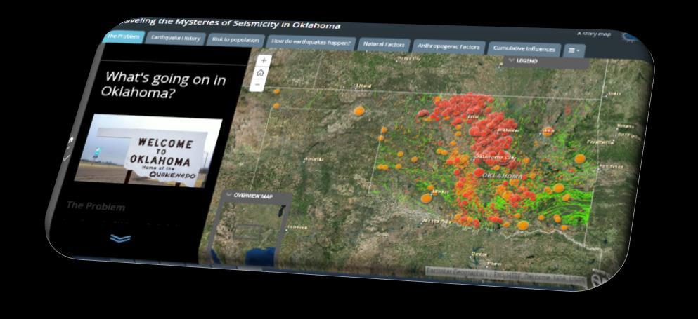
9 Implementation Results The Problem Landing page for application, discusses the recent seismicity the problem with current research
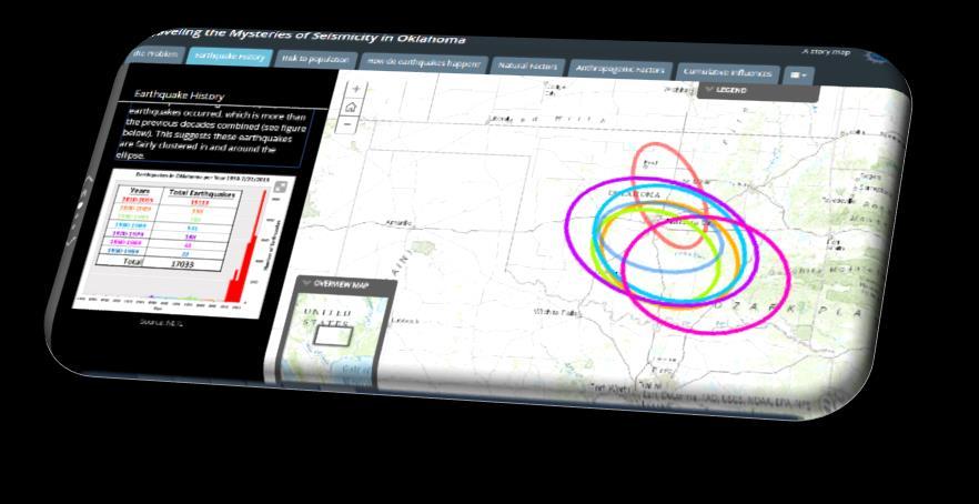
 Figure shows table shows table displaying number of earthquakes per decade and a plot displaying earthquake per year (colors correspond")
10 Implementation Results Earthquake History Discusses earthquake history through analysis: Directional distribution tool applied on each decade of earthquake occurrences (1950 7/22/2015) Figure shows table shows table displaying number of earthquakes per decade and a plot displaying earthquake per year (colors correspond to ellipses)
 by:")

11 Implementation Results Earthquake History Before and After heat maps for earthquake location density Plot displays annual earthquake data ( ) by: cumulative count earthquake count average magnitude maximum magnitude for entire earthquake catalog heat maps for earthquake location density and same plot for:

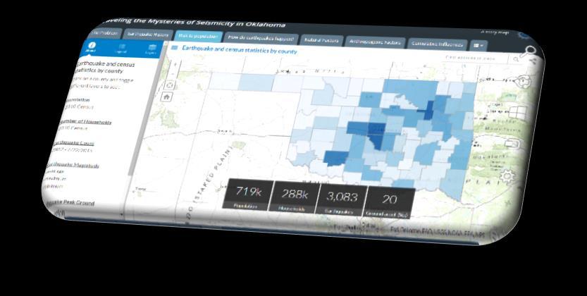
12 Implementation Results Risk to Population Used impact summary application template to: Display interactive map where users can obtain earthquake and population statistics by county on a dashboard (bottom of the screen)

13 Implementation Results How do earthquakes happen? Discusses physics and triggering mechanisms earthquakes

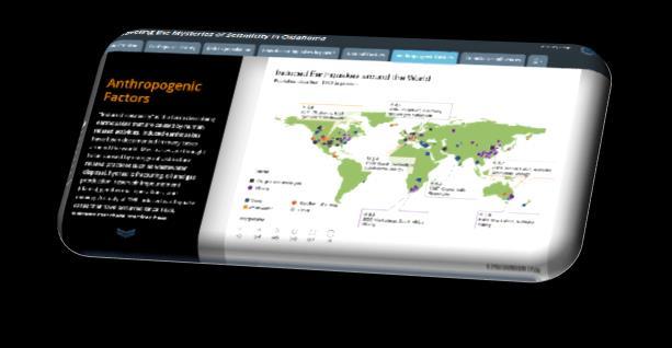
14 Implementation Results Natural Factors Anthropogenic Factors Natural and anthropogenic earthquake factors are examined in their respective tabs by exploring their background, datasets, and case studies through maps and analysis.
")


15 Implementation Results- case study example Natural Factors Case study (Van der Elst 2013) for remote earthquake triggering in Earthquake Triggering section Colored text are links to maps Three large remote earthquakes are thought to have triggered seismicity near Prague, OK Maps zoomed into area around Prague, OK. Resulting seismicity up to two weeks after 3 large remote earthquakes

16 Implementation Results- analysis example Anthropogenic Factors Four maps displaying well density in the oil and gas production section using Compare Analysis application template
, developed at the National Energy Technology Laboratories (NETL), was")

17 Cumulative Analysis The CSIL (Cumulative Spatial Impact Layers) tool (Bauer et al. 2015), developed at the National Energy Technology Laboratories (NETL), was used to examine the cumulative spatial extents for key data sets related to: Natural earthquake factors Anthropogenic earthquake factors All earthquake factors

 8 key datasets relating to 7 anthropogenic")

18 Implementation and Cumulative Analysis Results Natural Vs. Anthropogenic Natural and Anthropogenic Influences Cumulative Influences Map shows cumulative spatial sum of the 10 key datasets relating to 5 natural earthquake factors (left in blue) 8 key datasets relating to 7 anthropogenic earthquake factors (right in orange) Map shows cumulative spatial sum of All 18 key datasets related to natural and anthropogenic earthquake factors For every 100 square mile grid cell

19 Cumulative Analysis Results continued To examine the relationship between the number of earthquakes and the number of earthquake influences (datasets per grid cell) correlation coefficients were determined. Earthquake count per grid cell was calculated by spatially joining earthquakes from /22/2015 to each influence grid layer Natural Influences Anthropogenic Influences Natural and Anthropogenic Influences


20 Cumulative Results Cluster Analysis Natural Influences Examines how sum of influences accumulate spatially: Cluster of higher sums of influences in red Clusters of lower sums of influences in blue Anthropogenic Influences High value outlier surrounded by cluster of low values in orange Low value outlier surrounded by cluster of high values in green Natural and Anthropogenic Influences


21 Data overlay To visually examine any spatial correlations on individual natural and anthropogenic factors and the three spatial cumulative results, the two following layers were created:


22 Data overlay example Example showing heavy rainfall events from 1997 to June 2015

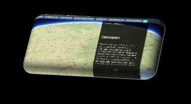
23 Implementation Results Conclusion and Bibliography Discusses conclusions and lists references for project
24 Discussion and Conclusion The final application presents an interactive story map providing information related to the probable factors related to the recent increase in seismicity in Oklahoma. Natural and human systems can act together and independently to increase the likelihood of seismic activity (Klose 2013). The difficulty lies in determining which factors have the greatest influence on seismicity, in a given area. Based on this examination via story map, further analyses and investigation are needed to help root out the risks and causes of the recent increase in seismicity in Oklahoma. Link to complete story map application
25 Key References Andrews, Richard D., Holland, A. (2015). Statement on Oklahoma and Seismicity: April, Oklahoma Geological Survey. Bauer, J. R. et al (2015). A Spatio-Temporal Approach to Analyze Broad Risks Potential Impacts Associated with Uncontrolled Hydrocarbon Release Events in the Offshore Gulf of Mexico; NETL-TRS ; EPAct Technical Report Series; U.S. Department of Energy, National Energy Technology Laboratory: Morgantown, WV, 2015; p 60. Klose, C. D. (2013). Mechanical and statistical evidence of the causality of human-made mass shifts on the Earth s upper crust and the occurrence of earthquakes. Journal of Seismology, 17(1), Nicks, Denver. (2014, June 17). Earthquake Insurance Becomes Boom Industry in Oklahoma. Time. United States Geological Survey (USGS). (2015). Graph of the Number of Oklahoma Earthquakes 1978 to Present. Walsh, F. R., & Zoback, M. D. (2015). Oklahoma s recent earthquakes and saltwater disposal. Science Advances, 1(5), e Wertz, Joe. (2014, January 14). Oklahoma Earthquake Rate is High, But Holding Steady. StateImpact.
Enhanced remote earthquake triggering at fluid injection sites in the Midwestern US
 Enhanced remote earthquake triggering at fluid injection sites in the Midwestern US Nicholas van der Elst 1 Heather Savage 1 Katie Keranen 2 Geoff Abers 1 1 Lamont-Doherty Earth Observatory 2 Cornell University
Recent Earthquakes in Oklahoma. and Potential for Induced Seismicity Austin Holland Oklahoma State Seismologist
 Recent Earthquakes in Oklahoma and the Mid-Continent: Significance and Potential for Induced Seismicity Austin Holland Oklahoma State Seismologist Outline Seismicity Rates in Mid-continent and Oklahoma
Impact Assessment Modeling:
 Impact Assessment Modeling: robust multivariate spatial analysis tools Lucy Romeo Jen Bauer, Jake Nelson, Dori Dick, Kelly Rose ORISE Fellow & Geospatial Researcher National Energy Technology Laboratory,
What We Know (and don t know)
") What We Know (and don t know) about the M5.1 La Habra Earthquake Dr. Robert Graves U.S. Geological Survey In collaboration with: Dr. Egill Hauksson and Dr. Thomas Göbel Caltech Dr. Elizabeth Cochran U.S.
What We Know (and don t know) about the M5.1 La Habra Earthquake Dr. Robert Graves U.S. Geological Survey In collaboration with: Dr. Egill Hauksson and Dr. Thomas Göbel Caltech Dr. Elizabeth Cochran U.S.
Rall Walsh and Mark Zoback
 Update to Oklahoma s Recent Earthquakes and Saltwater Disposal with 2014 Injection Data 1 Rall Walsh and Mark Zoback Fig. 1. Earthquakes and injection wells in Oklahoma. The map shows the locations of
1 of 5 12/10/2018, 2:38 PM
 1 of 5 12/10/2018, 2:38 PM The depth of the rock layer that serves as the disposal site for wastewater produced during unconventional oil extraction plays a significant role in whether that disposal triggers
Julie Shemeta, MEQ Geo Inc., WCEE Webinar 1/13/2016 1/14/2016
 1/14/16 1 Julie Shemeta, MEQ Geo Inc., WCEE Webinar 1/13/2016 1/14/2016 WSJ, Nov 16, 2015 Women s Council on Energy and the Environment (WCEE) January 13, 2016 http://www.cpr.org 1/7/2016 http://stateimpact.npr.org/texas/tag/earthquake/
Surface Processes Focus on Mass Wasting (Chapter 10)
") Surface Processes Focus on Mass Wasting (Chapter 10) 1. What is the distinction between weathering, mass wasting, and erosion? 2. What is the controlling force in mass wasting? What force provides resistance?
Surface Processes Focus on Mass Wasting (Chapter 10) 1. What is the distinction between weathering, mass wasting, and erosion? 2. What is the controlling force in mass wasting? What force provides resistance?
Kansas Underground Injection Control Program & Induced Seismicity. By: Benjamin Busboom Stinson Leonard Street
 Kansas Underground Injection Control Program & Induced Seismicity By: Benjamin Busboom Stinson Leonard Street What is underground injection? Unground injection is used to place fluid underground into porous
Concerns About the Poten/al for Induced Seismicity Associated with the Mississippian Play: Perceived or Real?
 Concerns About the Poten/al for Induced Seismicity Associated with the Mississippian Play: Perceived or Real? Aus/n Holland and Dr. G. Randy Keller Oklahoma Geological Survey University of Oklahoma 10/31/12
Analysis of Seismicity Coincident with Hydraulic Fracturing of a Well in South Central Oklahoma Amberlee Darold, Research Seismologist Austin
 Analysis of Seismicity Coincident with Hydraulic Fracturing of a Well in South Central Oklahoma Amberlee Darold, Research Seismologist Austin Holland, State Seismologist Oklahoma Geological Survey adarold@ou.edu
Oklahoma Earthquakes: Trends and Underlying Causes. Jeremy Boak, Oklahoma Geological Survey October 21, 2016
 Oklahoma Earthquakes: Trends and Underlying Causes Jeremy Boak, Oklahoma Geological Survey jboak@ou.edu October 21, 2016 1 The Oklahoma Geological Survey is a state agency for research and public service
From an earthquake perspective, 2011 was. Managing the Seismic Risk Posed by Wastewater Disposal. 38 EARTH April
 Liquid carbon dioxide has been injected into the Sleipner gas- and oilfield in the North Sea for 15 years without triggering any seismicity. It serves as a good example of how fluid injection can be done
Spatial Data Approaches to Improve Production and Reduce Risks of Impacts
 Spatial Data Approaches to Improve Production and Reduce Risks of Impacts Geospatial & Geostatistical Analyses to Improve Science-Based Decision Making Kelly Rose, Geology & Geospatial Research Lead Jennifer
Current Ph.D. College of Public Service and Community Solutions School of Public Affairs, Arizona State University, Expected Graduation-2019
 Jake R. Nelson October 2017 Arizona State University College of Public Service and Community Solutions 411 N Central Ave, Phoenix, AZ 85004. email:jakenels@gmail.com, jrnels20@asu.edu, nelsonjr@netl.doe.gov
FAQs - Earthquakes Induced by Fluid Injection
 of 1 http://earthquake.usgs.gov/learn/faq/?categoryid=46&faqid=357 4/23/2012 9:26 PM Q: Does the production of natural gas from shales cause earthquakes? If so, how are the earthquakes related to these
Potential Injection-Induced Seismicity Associated With Oil & Gas Development
 Potential Injection-Induced Seismicity Associated With Oil & Gas Development A primer on technical & regulatory considerations informing risk management & mitigation Second Edition September, 2017 www.statesfirstinitiative.org
Induced Seismicity: Can it Happen in Kentucky Too?
 Induced Seismicity: Can it Happen in Kentucky Too? Seth Carpenter Seismologist Geologic Hazards Section 2015 KGS Annual Seminar Outline - What s the problem? - Earthquake magnitude - Types of induced seismic
Are earthquakes triggered by hydraulic fracturing more common than previously recognized? Aus$n Holland and Amberlee Darold GSA South- Central Sec$on
 Are earthquakes triggered by hydraulic fracturing more common than previously recognized? Aus$n Holland and Amberlee Darold GSA South- Central Sec$on 2015 Earthquakes Triggered by Hydraulic Fracturing
Louisiana Transportation Engineering Conference. Monday, February 12, 2007
 Louisiana Transportation Engineering Conference Monday, February 12, 2007 Agenda Project Background Goal of EIS Why Use GIS? What is GIS? How used on this Project Other site selection tools I-69 Corridor
Risk Treatment. Todd Shipman PhD, Alberta Geological Survey/Alberta Energy Regulator November 17 th,2017 Induced Seismicity Workshop, Yellowknife NWT
 Risk Treatment Todd Shipman PhD, Alberta Geological Survey/Alberta Energy Regulator November 17 th,2017 Induced Seismicity Workshop, Yellowknife NWT Risk Management Approach to Induced Seismicity Establishing
Coastal Emergency Risks Assessment - CERA Real-Time Storm Surge and Wave Visualization Tool
 Coastal Emergency Risks Assessment - CERA Real-Time Storm Surge and Wave Visualization Tool Introduction This document provides guidance for using the Coastal Emergency Risks Assessment (CERA) visualization
Geoscience 106 syllabus (fall offering)
") Geoscience 106 syllabus (fall offering) Environmental Geology Class meetings: Three 50-minute meetings per week, typically MWF 9:55-10:45 A.M. Classroom: AB20 Weeks Hall Textbook: Environmental Geology
Geoscience 106 syllabus (fall offering) Environmental Geology Class meetings: Three 50-minute meetings per week, typically MWF 9:55-10:45 A.M. Classroom: AB20 Weeks Hall Textbook: Environmental Geology
DATA MINING THE KNOWN UNKNOWNS OF OKLAHOMA S CLASS II UIC DATA TO IMPROVE INJECTION INDUCED SEISMICITY STUDIES
 Groundwater Protection Council (GWPC) Underground Injection Control Conference Tulsa, OK Feb 13, 2018 DATA MINING THE KNOWN UNKNOWNS OF OKLAHOMA S CLASS II UIC DATA TO IMPROVE INJECTION INDUCED SEISMICITY
Risk Evaluation. Todd Shipman PhD, Alberta Geological Survey/Alberta Energy Regulator November 17 th,2017 Induced Seismicity Workshop, Yellowknife NWT
 Risk Evaluation Todd Shipman PhD, Alberta Geological Survey/Alberta Energy Regulator November 17 th,2017 Induced Seismicity Workshop, Yellowknife NWT Risk Management Approach to Induced Seismicity Establishing
GROUND-WATER LEVEL CHANGES IN U.S. AQUIFERS AS POTENTIAL TRIGGERS FOR EARTHQUAKES JUNE Jean Antonides
 GROUND-WATER LEVEL CHANGES IN U.S. AQUIFERS AS POTENTIAL TRIGGERS FOR EARTHQUAKES JUNE 2013 Jean Antonides NOTE: Outside sources of information cited or shown in this material will be referenced and given
A comparison of seismicity rates and fluid injection operations in Oklahoma and California: Implications for crustal stresses
 A comparison of seismicity rates and fluid injection operations in Oklahoma and California: Implications for crustal stresses Thomas Goebel California Institute of Technology Seismological Laboratory,
Using the Stock Hydrology Tools in ArcGIS
 Using the Stock Hydrology Tools in ArcGIS This lab exercise contains a homework assignment, detailed at the bottom, which is due Wednesday, October 6th. Several hydrology tools are part of the basic ArcGIS
What can I do with a major in Earth Information Science?
 Lewis-Clark State College offers a Bachelor of Arts or Science Degree in Earth Information Science through the Natural Sciences and Mathematics Division. You can learn more about the Natural Sciences and
Seismicity and the SWD-C4A well: An ongoing UIC case study in the Denver Basin, Colorado
 Seismicity and the SWD-C4A well: An ongoing UIC case study in the Denver Basin, Colorado Ground Water Protection Council Annual Forum October 6, 2014 Chris Eisinger Stuart Ellsworth Bob Koehler I. Colorado
Texas researchers dig into quake data Nathanial Gronewold, E&E News reporter Published: Thursday, January 18, 2018
 OIL Texas researchers dig into quake data Nathanial Gronewold, E&E News reporter Published: Thursday, January 18, 2018 Data published on the Bureau of Economic Geology's public TexNet portal show one year's
Oklahoma Corporation Commission
 Oklahoma Corporation Commission Oil and Gas Conservation Division Jim Marlatt, Oil and Gas Specialist Induced Seismicity Master of Science in Geology Spatial Information Systems Certification OCC and Seismicity
Using transient stresses to monitor poroelastic and stress conditions in CO 2 reservoirs
 Using transient stresses to monitor poroelastic and stress conditions in CO 2 reservoirs Andrew A. Delorey and Paul A. Johnson July 6, 2016 1 Stress, Pore Pressure, and Poroelastic Behavior Induced seismicity
A GEOGRAPHIC ASSESSMENT OF MAJOR DISASTER DECLARATIONS ACROSS THE LOWER 48 STATES
 A GEOGRAPHIC ASSESSMENT OF MAJOR DISASTER DECLARATIONS ACROSS THE LOWER 48 STATES A summary report produced by the Southern Climate Impacts Planning Program (SCIPP) Author: James Hocker Southern Climate
Geothermal Systems: Geologic Origins of a Vast Energy Resource
 Geothermal Systems: Geologic Origins of a Vast Energy Resource Energy From the Earth Energy-Land-Water Connections Speaker Series James E. Faulds, PhD Nevada State Geologist and Professor Nevada Bureau
New USGS Maps Identify Potential Ground- Shaking Hazards in 2017
 New USGS Maps Identify Potential Ground- Shaking Hazards in 2017 New USGS Maps Identify Potential Ground-Shaking Hazards in 2017 The central U.S. faces continued hazards from human-induced earthquakes
Leveraging Cross-Disciplinary Science for Induced Seismicity Risk Management
 Transatlantic Knowledge Sharing Conference on Unconventional Hydrocarbons: Resources, Risks, Impact and Research Needs Session 1 Induced Seismicity Amsterdam June 20, 2017 Leveraging Cross-Disciplinary
Leon Creek Watershed October 17-18, 1998 Rainfall Analysis Examination of USGS Gauge Helotes Creek at Helotes, Texas
 Leon Creek Watershed October 17-18, 1998 Rainfall Analysis Examination of USGS Gauge 8181400 Helotes Creek at Helotes, Texas Terrance Jackson MSCE Candidate University of Texas San Antonio Abstract The
Finite element modelling of fault stress triggering due to hydraulic fracturing
 Finite element modelling of fault stress triggering due to hydraulic fracturing Arsalan, Sattari and David, Eaton University of Calgary, Geoscience Department Summary In this study we aim to model fault
NUCLEAR POWER PLANT SITE SELECTION
 NUCLEAR POWER PLANT SITE SELECTION ABDELATY B. SALMAN Ex-Chairman Nuclear Materials Authority, Cairo, Egypt I. Introduction The aim of this article is to present the requirements and characteristics for
Are There Links Between Earthquakes and Oil & Gas Activity in Oklahoma?
 Are There Links Between Earthquakes and Oil & Gas Activity in Oklahoma? Randy Keller, Director Austin Holland, Research Seismologist Oklahoma Geological Survey Collaborators: Kyle Murray, Ken Luza, and
Induced Seismicity Potential in Energy Technologies
 Induced Seismicity Potential in Energy Technologies Conducted by the National Research Council s Committee on Induced Seismicity Potential in Energy Technologies Sponsor Department of Energy Overseen by
An Investigation on the Effects of Different Stress Regimes on the Magnitude Distribution of Induced Seismic Events
 An Investigation on the Effects of Different Stress Regimes on the Magnitude Distribution of Induced Seismic Events Afshin Amini, Erik Eberhardt Geological Engineering, University of British Columbia,
Figure 1. Carbon dioxide time series in the North Pacific Ocean (
 Evidence #1: Since 1950, Earth s atmosphere and oceans have changed. The amount of carbon released to the atmosphere has risen. Dissolved carbon in the ocean has also risen. More carbon has increased ocean
Outline Brief Overview MapPlace Website Data Delivery & Map Themes Digital Geology
 BRITISH COLUMBIA GEOLOGICAL SURVEY Kirk Hancock Pat Desjardins Nick Massey BRITISH COLUMBIA Ministry of Energy and Mines Ward Kilby acknowledged developer of MapPlace Outline Brief Overview MapPlace Website
What s Shaking in the Barnett Shale? STEP Dallas, August 11, 2015
 What s Shaking in the Barnett Shale? STEP Dallas, August 11, 2015 BSEEC.org @BSEEC Barnett Shale Facts The Barnett Shale was the first energy shale to be developed and therefore is the birthplace of the
Design Storms for Hydrologic Analysis
 Design Storms for Hydrologic Analysis Course Description This course is designed to fulfill two hours of continuing education credit for Professional Engineers. Its objective is to provide students with
Regulatory Considerations for Evaluating the Potential for Induced Seismicity of a Class I Non-Hazardous Disposal Well
 Regulatory Considerations for Evaluating the Potential for Induced Seismicity of a Class I Non-Hazardous Disposal Well Chad Milligan, P.G.-SCS Engineers Craig Pangburn, P.G.-T&C Consulting Many Options
Environmental Groups Warn Oklahoma Fracking Operators of Potential Legal Action
 Environmental Groups Warn Oklahoma Fracking Operators of Potential Legal Action Sierra Club & Public Justice Say Industry is Responsible for Increased Seismic Activity The following is the press release
How will induced seismicity in Oklahoma respond to decreased saltwater injection rates?
 SEISMOLOGY How will induced seismicity in Oklahoma respond to decreased saltwater injection rates? Cornelius Langenbruch* and Mark D. Zoback In response to the marked number of injection-induced earthquakes
#13 Earthquake Prediction
 #13 Earthquake Prediction Obvious importance Earthquake Prediction Save lives, reduce damage Earthquake Prediction - Types Long-range prediction - involves EQ probability over long time period (years to
Major Points in Introduction
 Near- Surface Processes and Resources John Louie - louie@seismo.unr.edu eismo. unr.edu Thomas Pratt tpratt@ocean.washington.edu ashington.edu Here is a Laundry List- With it, we can prioritize Major Points
B.2 Sources for Hazard Identification, Profiling, and Ranking (Section 3) Overview of Sussex County s History of Hazards
 Overview of Sussex County s History of Hazards") Appendix B Sources B.1 Sources for Planning Process (Section 2) FEMA. Mitigation Planning Guidance (386 Series). Available on the web at: http://www.fema.gov/plan/mitplanning/planning_resources.shtm FEMA
Appendix B Sources B.1 Sources for Planning Process (Section 2) FEMA. Mitigation Planning Guidance (386 Series). Available on the web at: http://www.fema.gov/plan/mitplanning/planning_resources.shtm FEMA
New Paltz Central School District Earth Science
 UNIT 1: MEASUREMENT AND DENSITY Measure volume, length, weight, and rate of Practicum during exam How do you accurately measure length, weight, change. Full lab write-up of density determination of and
You are Building Your Organization s Geographic Knowledge
 You are Building Your Organization s Geographic Knowledge And Increasingly Making it Available Sharing Data Publishing Maps and Geo-Apps Developing Collaborative Approaches Citizens Knowledge Workers Analysts
Unconventional Reservoir Development: The Role of Geoscience from a State Regulator s Perspective
 Unconventional Reservoir Development: The Role of Geoscience from a State Regulator s Perspective Nick Tew Alabama State Geologist and Oil and Gas Supervisor President, American Geosciences Institute Geological
StreamStats: Delivering Streamflow Information to the Public. By Kernell Ries
 StreamStats: Delivering Streamflow Information to the Public By Kernell Ries U.S. Department of the Interior U.S. Geological Survey MD-DE-DC District 410-238-4317 kries@usgs.gov StreamStats Web Application
Appendix 1: UK climate projections
 Appendix 1: UK climate projections The UK Climate Projections 2009 provide the most up-to-date estimates of how the climate may change over the next 100 years. They are an invaluable source of information
A Comparative Study of the National Water Model Forecast to Observed Streamflow Data
 A Comparative Study of the National Water Model Forecast to Observed Streamflow Data CE394K GIS in Water Resources Term Project Report Fall 2018 Leah Huling Introduction As global temperatures increase,
1 Complementary Access Tools
 ENERGY IHS AccuMap Shaped by industry and powered by IHS Markit information, AccuMap is a powerful and intuitive interpretation solution for the Canadian Energy Industry. 1 Complementary Access Tools AccuLogs
Outline 16: The Mesozoic World: Formation of Oil Deposits (with a side trip to the Devonian Marcellus Shale)
") Outline 16: The Mesozoic World: Formation of Oil Deposits (with a side trip to the Devonian Marcellus Shale) The first commercial oil well was drilled by Colonel Edwin Drake in Titusville, Pennsylvania,
Outline 16: The Mesozoic World: Formation of Oil Deposits (with a side trip to the Devonian Marcellus Shale) The first commercial oil well was drilled by Colonel Edwin Drake in Titusville, Pennsylvania,
Distribution of Regional Pressure in the Onshore and Offshore Gulf of Mexico Basin, USA
 Distribution of Regional Pressure in the Onshore and Offshore Gulf of Mexico Basin, USA Lauri A. Burke, Scott A. Kinney, Russell F. Dubiel, and Janet K. Pitman U.S. Geological Survey MS 939, Box 25046,
Potential Injection-Induced Seismicity Associated with Oil & Gas Development:
 2015 Potential Injection-Induced Seismicity Associated with Oil & Gas Development: A Primer on Technical and Regulatory Considerations Informing Risk Management and Mitigation Potential Injection-Induced
A comparison of seismicity rates and fluid-injection operations in Oklahoma and California: Implications for crustal stresses
 A comparison of seismicity rates and fluid-injection operations in Oklahoma and California: Implications for crustal stresses Thomas Göbel 1 Downloaded 06/03/15 to 130.118.44.150. Redistribution subject
Is It Safe to Frack Beneath Lake Lewisville?
 Is It Safe to Frack Beneath Lake Lewisville? Jerry Bartz, 2016 Data in this presentation are provisional and subject to revision and released on the condition that the author shall not be held liable for
Software requirements * :
 Title: Product Type: Developer: Target audience: Format: Software requirements * : Using GRACE to evaluate change in Greenland s ice sheet Part I: Download, import and map GRACE data Part II: View and
Topographic Maps and Landforms Geology Lab
 Topographic Maps and Landforms Geology Lab Ray Rector: Instructor Today s Lab Activities 1) Discussion of Last Week s Lab 2) Lecture on Topo Maps and Elevation Contours 3) Construct Topographic Maps and
Research in Induced Seismicity
 Research in Induced Seismicity Grant Bromhal, NETL GWPC Annual UIC Meeting January 22-24. 2013 1 NAS Study on Induced Seismicity Three major findings emerged from the study: hydraulic fracturing does not
Using Earthscope and B4 LiDAR data to analyze Southern California s active faults
 Using Earthscope and B4 LiDAR data to analyze Southern California s active faults Exercise 8: Simple landscape morphometry and stream network delineation Introduction This exercise covers sample activities
Stream Discharge and the Water Budget
 Regents Earth Science Unit 6: Water Cycle & Climate Name: Lab # Stream Discharge and the Water Budget Introduction: The United States Geological Survey (USGS) measures and publishes values for the daily
Management and Sharing of Hydrologic Information of Cache County
 Geographic Information System in Water Resources CEE6440 Fall Semester 2012 Management and Sharing of Hydrologic Information of Cache County To: Dr. David Tarboton Instructor By: Tian Gan Dec.7, 2012 I.
DOWNLOAD OR READ : UNITED STATES GEOLOGICAL SURVEY PROFESSIONAL PAPER PDF EBOOK EPUB MOBI
 DOWNLOAD OR READ : UNITED STATES GEOLOGICAL SURVEY PROFESSIONAL PAPER PDF EBOOK EPUB MOBI Page 1 Page 2 united states geological survey professional paper united states geological survey pdf united states
Exposure Disaggregation: Introduction. By Alissa Le Mon
 Exposure Disaggregation: Building Better Loss Estimates 10.2010 Editor s note: In this article, Alissa Le Mon, an analyst in AIR s exposures group, discusses how AIR s innovative disaggregation techniques
Internal microseismic event pattern revealed by waveform cross-correlation analysis
 Internal microseismic event pattern revealed by waveform cross-correlation analysis Bettina P. Goertz-Allmann, Volker Oye, Steven J. Gibbons, Robert Bauer, and Robert Will MGSC annual meeting September
Seismicity in Texas in Relation to Active Class I Underground Injection Control Wells: Preliminary Observations
 Seismicity in Texas in Relation to Active Class I Underground Injection Control Wells: Preliminary Observations David Murry Groundwater Protection Council UIC Conference Austin, Texas February 22, 2017
KENTUCKY HAZARD MITIGATION PLAN RISK ASSESSMENT
 KENTUCKY HAZARD MITIGATION PLAN RISK ASSESSMENT Presentation Outline Development of the 2013 State Hazard Mitigation Plan Risk Assessment Determining risk assessment scale Census Data Aggregation Levels
Induced Seismicity Potential in Energy Technologies
 Induced Seismicity Potential in Energy Technologies Robin K. McGuire Lettis Consultants International, Inc. Boulder, Colorado Committee on Induced Seismicity Potential in Energy Technologies, National
Earthquakes in Ohio? Teacher Directions and Lesson
 Earthquakes in Ohio? Teacher Directions and Lesson If I say, earthquake what state do you think of? Answers will vary, but California is a likely answer. What if I asked you, Where could you live in the
IMPERIAL COUNTY PLANNING AND DEVELOPMENT
 IMPERIAL COUNTY PLANNING AND DEVELOPMENT GEODATABASE USER MANUAL FOR COUNTY BUSINESS DEVELOPMENT GIS June 2010 Prepared for: Prepared by: County of Imperial Planning and Development 801 Main Street El
Toward interpretation of intermediate microseismic b-values
 Toward interpretation of intermediate microseismic b-values Abdolnaser Yousefzadeh, Qi Li, Schulich School of Engineering, University of Calgary, Claudio Virues, CNOOC- Nexen, and Roberto Aguilera, Schulich
Copernicus Overview. Major Emergency Management Conference Athlone 2017
 Copernicus Overview Major Emergency Management Conference Athlone 2017 Copernicus is a European programme implemented by the European Commission. The services address six thematic areas: land, marine,
5.2 IDENTIFICATION OF HAZARDS OF CONCERN
 5.2 IDENTIFICATION OF HAZARDS OF CONCERN 2015 HMP Update Changes The 2010 HMP hazard identification was presented in Section 6. For the 2015 HMP update, the hazard identification is presented in subsection
2013 FLOODS: MAPPING HYDROLOGY AND IMPACTS IN LARIMER COUNTY, COLORADO
 2013 FLOODS: MAPPING HYDROLOGY AND IMPACTS IN LARIMER COUNTY, COLORADO CE 394K GIS in Water Resources Fall 2018 Whitney Benson The University of Texas at Austin Introduction From September 11 th to September
DEP Office of Oil and Gas Management
 DEP Office of Oil and Gas Management Bureau of Oil and Gas Planning and Program Management Well Plugging and Subsurface Activities Division Production Waste Trends and Management May 19, 2017 2017 Shale
5.2. IDENTIFICATION OF NATURAL HAZARDS OF CONCERN
 5.2. IDENTIFICATION OF NATURAL HAZARDS OF CONCERN To provide a strong foundation for mitigation strategies considered in Sections 6 and 9, County considered a full range of natural hazards that could impact
Ivan Wong Seismic Hazards Group AECOM Oakland, CA. IEAGHG Monitoring Network Meeting. 10 June 2015
 Protocol and Best Practices for Addressing Induced Seismicity Associated With Enhanced Geothermal Systems (EGS) Ernie Majer Lawrence Berkeley National Laboratory Berkeley, CA and Ivan Wong Seismic Hazards
IDENTIFICATION OF HAZARDS OF CONCERN
 IDENTIFICATION OF HAZARDS OF CONCERN To provide a strong foundation for mitigation strategies considered in Section 6, the Village considered a full range of hazards that could impact the area and then
Challenges and Strategies for Monitoring Induced Seismic Activity
 Challenges and Strategies for Monitoring Induced Seismic Activity Designing and operating induced seismic monitoring networks to meet regulations Dario Baturan Geophysical Society of Tulsa 2015 Introduction
ambiguity in earth sciences IESO Geophysics Section Eddy hartantyo, Lab Geofisika FMIPA UGM
 ambiguity in earth sciences IESO Geophysics Section Eddy hartantyo, Lab Geofisika FMIPA UGM Pelatihan Tahap II IESO Teknik Geologi UGM Februari 2009 1 Introduction Photos from http://www.eegs.org/whatis/
Comparative Analysis of Hurricane Vulnerability in New Orleans and Baton Rouge. Dr. Marc Levitan LSU Hurricane Center. April 2003
 Comparative Analysis of Hurricane Vulnerability in New Orleans and Baton Rouge Dr. Marc Levitan LSU Hurricane Center April 2003 In order to compare hurricane vulnerability of facilities located in different
HEC & GIS Modeling of the Brushy Creek HEC & GIS Watershed Modeling of the
 HEC & GIS Modeling of the Brushy Creek HEC & GIS Watershed Modeling of the By Cassandra Fagan 5, December 2014 http://ubcwatershedstudy.ursokr.com/images/ Contents Introduction... 3 Figure 1: 24-hour rainfall
Towards Interactive QI Workflows Laurie Weston Bellman*
 Laurie Weston Bellman* Summary Quantitative interpretation (QI) is an analysis approach that is widely applied (Aki and Richards, 1980, Verm and Hilterman, 1995, Avseth et al., 2005, Weston Bellman and
Mapping Earth. How are Earth s surface features measured and modeled?
 Name Mapping Earth How are Earth s surface features measured and modeled? Before You Read Before you read the chapter, think about what you know about maps Record your thoughts in the first column Pair
Moore County Schools. High School Level
 Moore County Schools High School Level EARTH AND ENVIRONMENTAL SCIENCE Science, by nature, is an inquiry-based discipline whereby students gain knowledge through observation and experimentation. Scientific
Assessment and Mitigation of Ground Motion Hazards from Induced Seismicity. Gail M. Atkinson
 Assessment and Mitigation of Ground Motion Hazards from Induced Seismicity Gail M. Atkinson (with acknowledgement to many collaborators, especially Ghofrani and Assatourians) NSERC/TransAlta/Nanometrics
Core Curriculum Supplement
 Core Curriculum Supplement Academic Unit / Office EAS Catalog Year of Implementation 2018-2019 Course (Prefix / Number) GEOL / 1370 Core Proposal Request Add to Core Curriculum Course Title Natural Disasters
Miami-Dade College. The student will demonstrate a basic knowledge of the origin and evolution of the Earth and its planetary environment.
 Miami-Dade College Common Course Number: GLY 3884 Course Title: Environmental Geology Catalog Course Description: This course focuses on the study of the application of geology to the interactions between
Finding Fault Geologic History from a Road Cut
 Finding Fault Geologic History from a Road Cut Elisabeth M. Price, DD LaPointe, and Jonathan G. Price 4 July 2005 Introduction Earth science is an important science to present to students because it directly
Physical Geography: Patterns, Processes, and Interactions, Grade 11, University/College Expectations
 Geographic Foundations: Space and Systems SSV.01 explain major theories of the origin and internal structure of the earth; Page 1 SSV.02 demonstrate an understanding of the principal features of the earth