1974 GEOLOGICAL h GEOCHEMICfiL
|
|
|
- Clifton Wiggins
- 5 years ago
- Views:
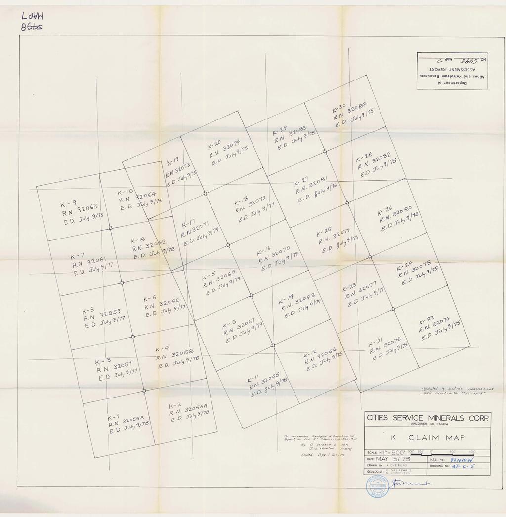
Transcription
1 1974 GEOLOGICAL h GEOCHEMICfiL ASSESSMENT R.EPORT ON THE
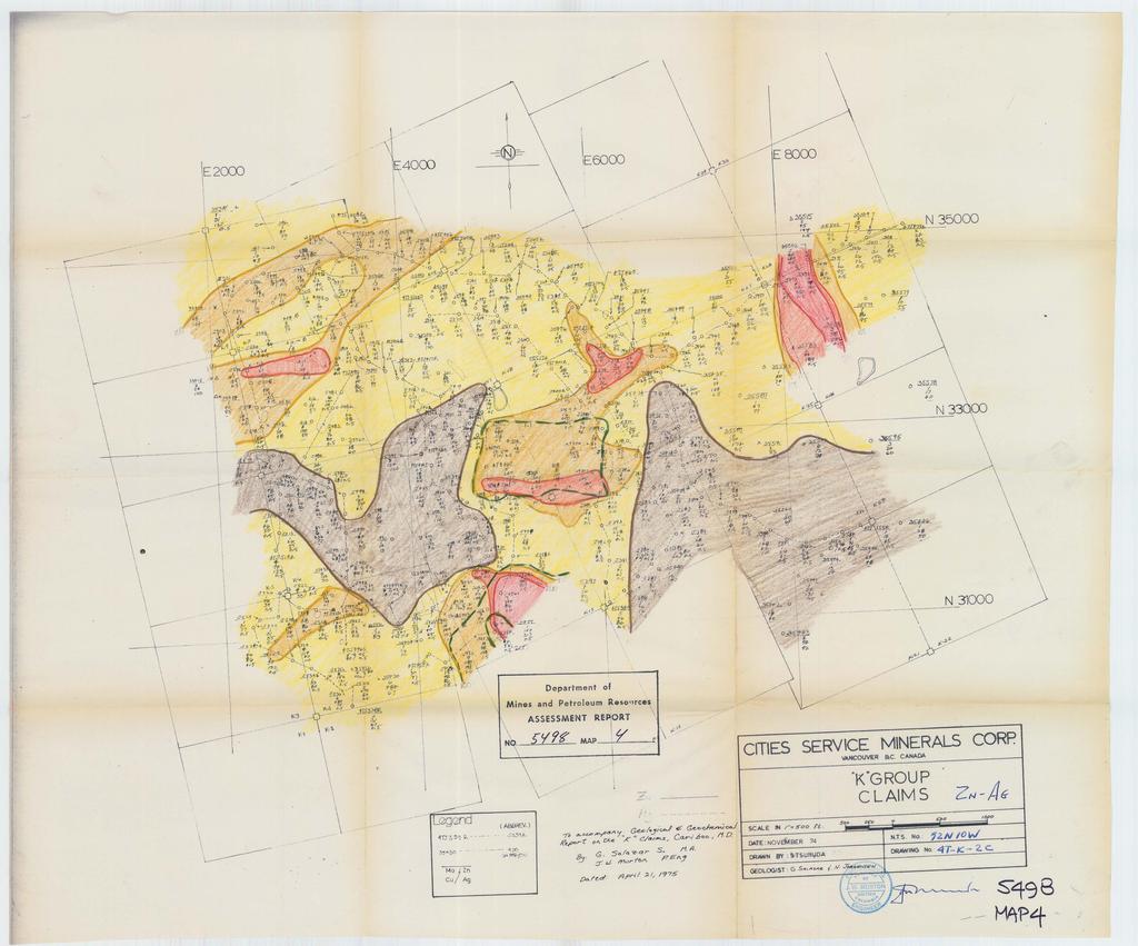
2 6. TABLE OF CONTENTS B Page CONCLUSIONS & RECOMMENnATIONS *.*I LOCATION & ACCESS CLAIM STATUS SllMlfMtY OF WORK DONE IN 1374 PIPS TORY REGIONAL GEOLOGY *4 LOCAL GEOLOGY A) Petrology B) Structure C) Geochemistry D) Hydrothermal Alteration 0 E) Geophysics STATEMENT QF EXPENDITURES (1974) CERTIFICATIONS: J. We Murton, Po Eng, G. Salazar So, &A. APPENDIX A - ANALYTICAL PROCEDURES I 1) LOCATION MAP /& Cio/n? c ~ A P 2) GEOCHEMICAL MAPS /' 2 2,) Copper 3 2B) Molybdenum 26) Zinc & Silver 5 3) CEM.OCTCAT. GEOLOGICAL MAP k 4) IP SECTION "1) CLAIM MAP
3 CONCLUSIONS & ESXOMMENDATIONS A coincident Cu-Mo rock geochemical anomaly about 1800 feet in diameter centered about 400' north of the Initial Posthr claims K-15 and K-16 with values greater than 300 ppm Cu and 10 ppm Mo and very weak silver values was found in an environment of suspected strong leaching of copper sulphides. This anomaly is located in the northwest edge of a hornblende quartz monzonite stock of complex tectonic history and is partly surrounded by a hook-like plug of granodiorite porphyry that grades into the former phase of the stock to the east, The granodiorite porphyry also grades into a texture destructive quartz eyed-sericite porphry rock as one gets closer to the anomalous area, 0 Two major fault systems, one trending N oo-20 W and dipping '~ and the second trending ~ 7 and 0 dipping ~ ~ 65 N join at the head of the main valley. These fault systems are expressed in the field as either dacitic dykes or indurated gouge zones of large but variable widths. 0 The N70 W fault system may be younger and have a right lateral displacement if the dyke near sample site 4TJ0361R proves to be the 0 0 continuation of the N 0-20 W fault system, C A broad zone of secodary biotite appears to be related to the N 0-20"~ fault system. An iron sulphide zone composed.-of pyrite and/or pyrrhotite covers the north eastern half of the "main anomaly". Three the "main anomaly".

4

5
6 * LOCATION & ACCESS 0 This claim group is located 20 miles S58 W from Tatla Lake 0 Post Office and 3.2 miles N57 W from the north end of Middle Lake, as the crow flies, Access to the area was by helicopter (Bell 47 G3B1) from Tatla Lake, but there is a road from Tatla Lake to Middle and Twist Lakes that could be used to shorten the distances somewhat, This road is privately owned from the north end of Middle Lake southwards, and the ranchers at Twist and Middle Lakes would have to be contacted
7 Rental & Claim Tag Staking Record Recording Assessment No. No. Date No, Date Due Date Remarks 0 -! K M July 1/ July 9/74 July 9/78 1 I I! I1 11 I1 2 52M 56A 11 I M 57 9/77 t 1 I1 S l 4 54M " 58 9/78 I1 If II 5 55M " 59 9/ II 6 56M 60 9/78 I I I1 It 7 57M 6 P " 9/77 If 11 II 8 58M " 62 9/78 I I M " 63 " 9/75) No. 2Post I I 91 II II II 10 60M " 64 ) was witnessed, I1 I1 11 6PM Jun 10/ / II 12 62M " 66 9/ It 13 63M " 67 " 9/ M " I1 II I1 If 15 65M I' I1 69 If ti 11 I M " I1 70 I1 I1 II II II II 11 t 17 67M II M 72 '# 9/77 I I II II 19 69M " 73. " 9/75 ) No, 2 Post 20 70M ".I I I1 II If ) was witnessed. I 21 71M July 1/74 75 II II I I 11 I M " 76 II II M II 77 II 11 9/ M " /75 It 1I It 25 75M " 79 9/16 11 If I1 i 26 76M " 80! 9/75 I I I1 II 27 77M I' 81 9/76 I1 I1 I M " 82 9/75 11 I1 I N " 83 " 9/75 11 It I M 84 II II - C Note: Assessment and rental due dates are those in effect after filing and acceptance of t& report. \ 1 0 \
8 SUMMARY OF WORK DONE IN ) Detail geological mapping and geochemical sampling was done by our Crew No, 1 (Neil Jorgensen and Tim Osterstock), 2) 195 samples (151 rock, 22 soil, 21 talus and 1 stream) were collected, Serial numbers are: 4TJ0360R to 4TJ0555R, excluding 4TJ0368R. 3) Crew was moved into the area on June 29, 1994 and left it on August 3, 1974, for a total of 31 working days, of which 10 were lost due to bad weather, 4) A total of 31,2 hours of helicopter times was used, 5) One line of IP down the main valley bottom was run in August 16-18/74, The line was 2800' long and the results proved to be unreliable due to lack of good contacts in the very heavy bouldery talus covering the valley bottom, HISTORY This area is underlain by one of the larger gossans found in the Tatla Lake area, The area was explored during the 1973 field season and reported under Drawing (15), b Last year's results indicated an area with coincident anomalous \ values in copper and molybdenum surrounded by a weak zinc anomaly, Strongly silicified, sericitized and pyritized andesitic and dacitic vol- canic~ and tuffs were reported, Most striking of all was rock sample 35303, located in the center of the anomalous area, that assayed 48 ppm Mo, and 1040 ppm (8,104%) Cu, Staking of the area as soon as possible was recommended based on this data if a cursory examination of the area corroborated the results. Snow and weather conditions did not allow us
9 to investigate the main anomalous area prior to staking, but a couple of short visits and helicopter hops to the ridges on the east side of the main area of interest revealed the presence of quartz eyed-sericite porphyry rocks, increasing our interest. I REGIONAL GEOLOGY The staked area is underlain by Hauterivian and younger andesitic and basaltic agglomerates ad tuffs intruded by Cretaceous to Tertiary granodioritic to quartz monzonitic plugs of the Coast Crystal- line Belt, The "main anomaly" is located in the northwestern corner of a complex granodioritic stock of about ' in diameter with quartz and feldspar phenocrysts and cut by numerous quartz and/or epidote veins and veinlets, The area does not appear to be directly related to any of the I I major fault systems that traverse the region, LOCAL GEOLOGY This section is restricted to the ''main anomalous area" and its immediate vicinity. C A) Petrology The oldest rocks in the area are tuffs and agglomerates of andesitic to dacitic compositiono Fragments are usually 0,2 to 0,5 inches in diameter, although blocks of up to a foot are repcrted, Grain size of the matrix varies from fine to coarse, and color of the rocks vary from black to green or white depending on the intensity of hydro- thermal alteration and/or secondary leaching, These rocks are generally well fractured, and probably contain a certain amount of syngenetic pyrite and/or pyrrhotite,
10 A small area of very impure quartzites and greywackes out- crops to the east of the "main anomaly", It is described megascopically as,.,"fine to medium grained gray to green impure quartzite, " but cauld be an ashy or sandy volcanic horizon or pocket, As mentioned above, these vokanics are intruded by a granodioritic stock with an apparent complex plutonic history in its northwestern corner, which is where our "main anomaly" is, The stock in this area is formed by two plugs that may join at depth and that appear to form a hook around the ''main anomaly" underneath the glacial debris co- vering the 'hain valley". The plug to the east of the ''main valley" appears to be older, larger, more complex and not as altered as the one to the west, Also, the youngest (?) phase of the complex stock seems to be equivalent in age, composition and texture to the plug located J to the west of the "main valley", The older (?) phase of the plug in the east side is a hornblende quartz monzonite, described megascopically as a medium to fine grained, granular, grey to green rock with strong magnetite content in the ground- mass and numerous quartz and/or epidote veinlets, The younger (?) phase is a quartz feldspar granodiorite porphyry, with quartz and/or feldspar phenocrysts to about 0,5", a medium to fine grained groundmass and, locally, I with strong magnetite as well, This rock grades into a quartz eyed por- phyry rock with texture destructive sericite and secondary clay alteration narer the "main anomaly". Some magnetite phenocrysts and magnetite crystals with pyrite cores are reporrted in this quartz eyed-sericite porphyry, The plug to the west of the "main anomaly" is identical to this younger phase (megascopically).
11 Numerous dacitic and andesitic dykes, both fresh and altered, cut through the area and appear to be controlled by the major structural systems present in the area, B) Structure Two major systems, one trendi ng N 0' W and dipping W 0 0 and theother trending N70 W and dipping 65 N appear to intersect just north of the "main anomaly", and are expressed as dacite dykes of up to 100' (true) width and/or highly indurated gouge zones of up to 20' l 0 (true) width, The system trending N70 W seems to be younger and may have a right lateral displacement if the dyke mapped just west of sample 4TJ0361R proves to be the continuation of the dyke zone just west of I the 'hain anomaly", Fracturing elsewhere is very intense, randomly oriented, and most of the leached out zones recognized are coincident with area where I fracturing is most intense, A zone of very intense quartz-magnetite- I biotite-feox-pyrite stockwork veining is Geen adjacent to the "main anomaly ", C) Geochemistry A total of 195 samples (151 rocks, 22 sails, 21 talus and 1 stream) were collected as part of this year's work in the area, Tkse I samples were assayed geochemically for molybdenum, copper, zinc and silver by Chemex Labs of Vancouver, B,C,, using standard atomic absorp-... tion methods, This year's values corroborated last year's survey, and stressed the importance of the ''main valle! axea, although no values as high as the ones encountered in last yearus survey were found this year.
12 The ruggedness of the terrain did not allow us to treat this area in the usual manner of either cutting or flagging a grid of lines over the area and then taking samples at constant intervals, Instead, we had our crews tow a 200P chain collecting samples every feet while mapping, As a result of this apprcach, all our time was spent where there was rock in outcrop, and very few samples were collected from the valley bottom, Also, a somewhat different method of outlining anomalies was used in this area because of the amount of rock samples taken, In this case, only groups of samples that appear to outline an area or zone of similar or higher range of values was countoured regardless of the presence of a few erratic anomalous values (either high or f low) within the area. As an example, Sample 35304, in the middle of the 'hain anomaly" is disregarded because all the other samples defining it have greater than 150 ppmes of copper; by the same token, sample is not of much interest to us because the molybdenum assays of the surrounding rocks are much smaller, making it a one sample anomaly, The greater than 100 ppm Cu contour outlines an area about 2000' wide trending ~35'~ that is open, but very broken up, to the south- west, and that is closed off to the northeast at the westsern contact between the older (?) hornblende quartz monzonite and the other rocks on the west side of the east wall of the 'hain valley", Tk ""main ano- maly'' is located in the northern third of this area, is about 1700 x 1000 elongated ~ 5 5 ' and ~ ~ both the 150 ppm and the 200 ppm Cu contours cover the same area, The 300 ppm Cu contour is similar to the other two but shows a narrow break in the southern third thatt*could be due to the fact that the samples in the valley bottom have been tken into con- sideration, although they may not reflect,bedrock. The open end to the southwest is of less immediate importance because of the size of the
13 anomalies found to date. Molybdenum appears to be more erratic than copper, and one or two sample anomalies are more common and their significance is more difficult to evaluate. The 6 ppm Mo contour outlines an area abmt 1500' wide trending ~15'~ that is open but very broken to the south, and closed off to the north, in the same area that the copper anomaly is closed off, The 10 ppm Mo contour is concentric with the 150 ppm Cu contour but somewhat larger to the north (where it also coveres the quartz stockwork area) and to the east and southeast. The 15 ppm Mo contour outlines very small areas on the edge of the 300 ppm Cu contour, and one of them is directly related to the quartz stockwork area, The 100 ppm Zn contours portray coincident and peripheral relationships to the "main anomaly", but appears to be peripheral to the main intrusive body, although it seems to cut through the older (?) plug. The contours peripheral to the '"main anomaly1' are also peripheral to the hook of intrusive rocks proposed above, and the area coincident with the 'hain anomalylbppears to extend to the northeast beyond the high Cu-Mo contour so The significance of this Cu-Mo anomalous area is enhanced by I I I the fact that leaching of at least copper is expected to be highly ef- ficient because of the abundance of pyrite and the presence of strongly leached out. rocks in the vicinity of the 'hain anomaly", D) Hydrothermal A1 teration - *.. appear to show some zoning characteristics in t and are as follows :
14 Epidote is widespread on the foot wall side of the N 0 ~ ~ ~ fault system and almost non existant to the west of it. There appears to be a higher concentration of epidote near the junction of the two fault systems and to the northeast of the "sin anomalys' but no sug- gestion of an epidote zone is recognized at the present, The area in between the ~70'~ fault system and the 'hain anomaly" going as far west as the fault systems junction at the head of the valley carries more than the average amount of pyrite (greater than 5%) as well as significant amounts of pyrrhotite, Another smaller area with high pyrite content is coincident with the southeastern edge of the anomaly, giving the distribution of the areas with a higher than average amount of iron sulphides, a cane shape with its handle wrapped around the eastern side of the "main anomaly", Two areas with moderate to strong magnetite were also re- cognized. One of them coincides with the stockwork of quartz-mag- netite-biotite-sulphides veinlets just west of the main anomaly, The second zone is much larger in size and corresponds closely with the outline of the older (?) hornblende quartz monzonite plug, Most of the magnetite in this plug is associated with chlorite, hnd both appear to be replacing hornblende and other mafics, Secondary biotite was recognized megascopically along the footwall of the N 0-200w fault system in a zone that appears to narrow down from 1200' to 500' wide as one goes southward, Most of this biotite occurs as fracture filling and is strongest in the stockwork area, A *.h.o zone of no or little secondary biotite within this zone and just west of the stockwork was also recognized, U

15

16
17
18
19

20

21
22

23

24
25
The Cobalt Rainbow. Airborne geophysical maps show that a north trending aeromagnetic high suggests further undiscovered mineralisation.
 The Cobalt Rainbow The property is located on Greenstone Creek, approximately 4.8 kilometres south west of the creek mouth. The property is located about 24 km due west of Campbell River, in the east-central
lat ' N Long ' W
 305 7 ec1;, REPORT ON THE JERY CLAIMS OF POLA RESOURCES LTD. NTS 93L/16 0 0 lat. 54 45' N Long. 126 22' W BABIXE LAKE AREA OMINECA MINING DIVISION, B.C. PAUL PLICKA CONSULTING GEOLOGIST DECEMBER 30, 1981
Drill locations for the 2015 program are highlighted in the geology map below.
 2015 Exploration Program The exploration program plan at KSM for 2015 was designed to improve the understanding of block cave targets and support engineering/environmental aspects of development scenarios.
LINGIG PORPHYRY COPPER DISCOVERY
 MEDUSA MINING LIMITED ABN: 60 099 377 849 Unit 7, 11 Preston Street Como WA 6152 PO Box 860 Canning Bridge WA 6153 Telephone: 618-9367 0601 Facsimile: 618-9367 0602 Email: admin@medusamining.com.au Internet:
FIRST YEAR ASSESSMENT REPORT PROSPECTING LICENCE 16512M MARYSTOWN AREA, BURIN PENINSULA NTS 1M/3
 FIRST YEAR ASSESSMENT REPORT OF PROSPECTING ON LICENCE 16512M MARYSTOWN AREA, BURIN PENINSULA NTS 1M/3 BY NATHANIEL NOEL MSc. FOR E. MICHELE NOEL MINERAL LICENCES: 16512 M WORK CONDUCTED: MID-SEPTEMBER
Introducti on. Land Survey. Geomagnetic Survey. Geomagnetic Results and Interpretati ons - Conclusions and Recommendations C
 m M 42A86SW8281 63.42 PRICE 010 C O H T E H l 42A86SW828I 63.42 PRICE 010C Introducti on Land Survey Geomagnetic Survey Geomagnetic Results and Interpretati ons - Conclusions and Recommendations - - -
BCGold Corp. Discovery Driven
 BCGold Corp. Discovery Driven Sickle-Sofia Property Copper-Gold Porphyry Discovery in the Toodoggone Camp! Cautionary Statement This presentation does not constitute an offer to sell or solicitation of
W. 1.NELSON Jr. P. ENG.
 GEOCHEMICAL AND GEOPHYSICAL SURVEY SNO GROUP CLAIMS W. 1.NELSON Jr. P. ENG. NORANDA EXPLORATION COMPANY, LIMITED OMINECA MINING DIVISION AUG. 17, 1971 - AUG. 29, 1971 TABLE OF CONTENTS - Page INTRODUCTION
 ..m,"f.k*"--v- A tot,al of 18 line miles of magnetometer surveying was completed on the "B" and "J" claim groups during August of 197. Approximately two-thirds of the area covered by the survey is glaciated,
Paupong; a new gold-silver-copper field in the SE Lachlan. BJ Barron H Degeling RJ Fountain and T Klein. Alt Resources Ltd.
 Paupong; a new gold-silver-copper field in the SE Lachlan BJ Barron H Degeling RJ Fountain T Klein Alt Resources Ltd Abstact The Paupong project is a new discovery of outcropping gold-silver-base metal
COPPERSTONE RESOURCES AB INTERCEPTS ZONE OF CHALCOPYRITE-ARSENOPYRITE- BORNITE MINERALIZATION AT SVARTLIDEN IN FIRST DEEP DRILLHOLE FROM 720m-810m
 COPPERSTONE RESOURCES AB INTERCEPTS ZONE OF CHALCOPYRITE-ARSENOPYRITE- BORNITE MINERALIZATION AT SVARTLIDEN IN FIRST DEEP DRILLHOLE FROM 720m-810m In mid-january 2017 Copperstone Resource published a geological
ARGENTINE FRONTIER RESOURCES INC (AFRI) SALTA EXPLORACIONES SA (SESA)
 SALTA EXPLORACIONES SA (SESA)") ARGENTINE FRONTIER RESOURCES INC (AFRI) SALTA EXPLORACIONES SA (SESA) LA SARITA IOCG-Porphyry Copper-Gold August 2006 La Sarita Cateo 2 La Sarita - bleached center is Taca Taca Arriba. The hematite zone
ARGENTINE FRONTIER RESOURCES INC (AFRI) SALTA EXPLORACIONES SA (SESA) LA SARITA IOCG-Porphyry Copper-Gold August 2006 La Sarita Cateo 2 La Sarita - bleached center is Taca Taca Arriba. The hematite zone
GEOLOGY OF THE NICOLA GROUP BETWEEN MISSEZULA LAKE AND ALLISON LAKE
 GEOLOGY OF THE NICOLA GROUP BETWEEN MISSEZULA LAKE AND ALLISON LAKE (92H/15E. 10E1 By V. A. Preto INTRODUCTION Mapping was continued southward from the area covered in 1973 and an additional 55 square
GEOLOGY AND LITHOGEOCHEMISTRY OF THE CHILKO-TASEKO LAKES AREA* BY G.
 B Ministry of Energy, Mines and Petroleum Resources GEOLOGICAL BRANCH MINERAL RESOURCES DIVISION NOTES TO ACCOMPANY OPEN FILE - GEOLOGY AND LITHOGEOCHEMISTRY OF THE CHILKO-TASEKO LAKES AREA* BY G. P. McLAREN
 >
> DISCOVERY OF MINERALISED PORPHYRY & MAGNETITE-COPPER-GOLD AT KAMARANGAN
 MEDUSA MINING LIMITED ABN: 60 099 377 849 Unit 7, 11 Preston Street Como WA 6152 PO Box 860 Canning Bridge WA 6153 Telephone: +618-9367 0601 Facsimile: +618-9367 0602 Email: admin@medusamining.com.au Internet:
ASSESSMENT REPORT. Geochemical and Geological Surveys. on the. Gooch#1-4. Mineral Claims. Omenica Mining District NTS 93L/7W
 f- GEOLOGICAL BRANCH ASSESSMENT REPORT ASSESSMENT REPORT Geochemical and Geological Surveys on the Gooch#1-4 Mineral Claims Omenica Mining District NTS 93L/7W LAT: 54O25'W LONG: 126O26'W Operator: SMD
The MAPLE BAY PROJECT Copper Silver - Gold
 The MAPLE BAY PROJECT Copper Silver - Gold Good grade and tonnage potential within close proximity to Tidewater The Maple Bay Copper Silver Gold Project covers highly favourable geological host rocks of
3. GEOLOGY. 3.1 Introduction. 3.2 Results and Discussion Regional Geology Surficial Geology Mine Study Area
 3. GEOLOGY 3.1 Introduction This chapter discusses the baseline study of the geology and mineralization characteristics of the mine study area. The study consolidates existing geological data and exploration
PROSPECTING REPORT. Medallion Property. EVENT # TENURE # Tenure Name: GPEX CLVIII Medallion
 2006-2007 PROSPECTING REPORT Medallion Property EVENT # 4167980 TENURE # 540362 Tenure Name: GPEX CLVIII Medallion Watson Bar Region Clinton Mining Division Map 092O Central Coordinate Reference Long.
=%REPORT RECONNAISSANCE OF CHISHOLM LAKE PROSPECT. October 25, 1977
 =%REPORT ON FIELD RECONNAISSANCE OF CHISHOLM LAKE PROSPECT October 25, 1977 Bruce D. Vincent Imperial Oil Limited, Minerals - Coal, CALGARY, ALBERTA CHISHOLM LAKE PROSPECT Introduction The Chisholm Lake
Serengeti Resources Inc GEOCHEMICAL REPORT ON THE SHADOW PROPERTY a.
 Serengeti Resources Inc. 2004 GEOCHEMICAL REPORT ON THE SHADOW PROPERTY a. Located in the Johanson Lake Area Omenica Mining Division NTS 94D/9 6 degrees and 32 minutes North Latitude 126 degrees and 2
SECOND and THIRD YEAR ASSESSMENT REPORT PROSPECTING LICENCE M, ROCK CUT PROPERTY, NTS 1N/12, NEWFOUNDLAND. ROY FRENCH (licence holder )
") SECOND and THIRD YEAR ASSESSMENT REPORT Of PROSPECTING On LICENCE 013704M, ROCK CUT PROPERTY, NTS 1N/12, NEWFOUNDLAND. By ROY FRENCH (licence holder ) Work Conducted: Sept. 17, 2008 Nov. 03, 2009 Total
SECOND and THIRD YEAR ASSESSMENT REPORT Of PROSPECTING On LICENCE 013704M, ROCK CUT PROPERTY, NTS 1N/12, NEWFOUNDLAND. By ROY FRENCH (licence holder ) Work Conducted: Sept. 17, 2008 Nov. 03, 2009 Total
ASSESSMENT REPORT GEOLOGICAL BRANCH. 50' 23 'North. GEOLOGICAL and GEOCHEMICAL SURVEYS ON THE. PUTNAM PROPERTY (Putnam Mineral Claim)
") GEOLOGICAL and GEOCHEMICAL SURVEYS ON THE PUTNAM PROPERTY (Putnam Mineral Claim) VERNON MINING DIVISION, B.C. GEOLOGICAL BRANCH ASSESSMENT REPORT NTS : Latitude: 82L17W 50' 23 'North LOCATION, ACCESS,
GEOLOGICAL and GEOCHEMICAL SURVEYS ON THE PUTNAM PROPERTY (Putnam Mineral Claim) VERNON MINING DIVISION, B.C. GEOLOGICAL BRANCH ASSESSMENT REPORT NTS : Latitude: 82L17W 50' 23 'North LOCATION, ACCESS,
on the SALAL CREEK MOLYBDENUM PROPERTY, SALAL CREEK, B.C. LILLOOET MINING DIVISION, BRITISH COLUMBIA
 on the J PLUG 9-12, PLUG 19-24, BAT 10-14, BAT 15 Fr., BAT 16 Fr. MINERAL CLAIMS, SALAL CREEK MOLYBDENUM PROPERTY, SALAL CREEK, B.C. LILLOOET MINING DIVISION, BRITISH COLUMBIA N.T.S. 92 J 14 LATITUDE 50
Revelo Defines Porphyry Copper Targets at its Calvario Project
 www.reveloresources.com NEWS RELEASE #01/2015 Revelo Defines Porphyry Copper Targets at its Calvario Project Vancouver - February 03, 2015 - Revelo Resources Corp. ( Revelo or the Company ) (TSX-V: RVL)
NEW HAZELTON, OMINECA M.D.,
 PROSPECTING REPORT JUDI 1 TO 6 MINERAL CLAIMS NEW HAZELTON, OMINECA M.D., B.C. MAP 93M/4E, LAT. SS014'N, LONG. 127'33'W OWNED BY: A. L'ORSA ANTHONY L'ORSA Smithers, B.C. 21 February, 1981 TABLE OF CONTENTS
DONUT CLAIM (Tenure # )
") ASSESSMENT REPORT (Event #5409561) describing PROSPECTING on the DONUT CLAIM (Tenure # 848582) Kamloops Mining Division NTS: 104M/14 & 104M/13 UTM: 8 V 472483 6648727 (NAD 83) Claim owner: Bradley S. Wilson
ASSESSMENT REPORT (Event #5409561) describing PROSPECTING on the DONUT CLAIM (Tenure # 848582) Kamloops Mining Division NTS: 104M/14 & 104M/13 UTM: 8 V 472483 6648727 (NAD 83) Claim owner: Bradley S. Wilson
Pacific Empire Minerals Provides Copper King RC Drilling Results
 Pacific Empire Minerals Provides Copper King RC Drilling Results November 1, 2018 - Vancouver, BC, Canada - Pacific Empire Minerals Corp. (TSXV: PEMC) ( Pacific Empire, PEMC or the Company ), a hybrid
EXISTING GEOLOGICAL INFORMATION
 CHAPER 3 EXISTING GEOLOGICAL INFORMATION 3-1 General Geology of the Surrounding Area (1) General geology and ore deposits in Mongolia Geographically, Mongolia is a country located between Russia to the
GEOLOGIC REPORT. on the. NTS- 92 L/ 12 co-ords 50~37.5'~ 127~32'~ Owned by UTAH MINES LTD. GORDON MILBOURNE. Operator UTAH MINES LTD.
 GEOLOGIC REPORT on the " - SUNSET GROUP OF CLAIMS NTS- 92 L/ 12 co-ords 50~37.5'~ 127~32'~ Owned by UTAH MINES LTD. & GORDON MILBOURNE Operator UTAH MINES LTD. BY G.L. Holland Geol ogi st June 15, 1983
GS-17. Summary. Previous work. Regional setting. Introduction. Geology
 GS-17 Geology, structure and mineralization of the Ore Fault property, Bird River greenstone belt, southeastern Manitoba (parts of NTS 52L5NE and 52L6NW) by L.A. Murphy 1 and P. Theyer Murphy, L.A. and
ON THE GEOLOGICAL AND MAGNETOMETER SURVEYS ON THE FANG NO. 1 TO 9 AND NO. 10 FRACTION MINERAL CLAIMS PROJECT 6051 N.T.S.
 AN INTERIM REPORT ON THE GEOLOGICAL AND MAGNETOMETER SURVEYS ON THE FANG NO. 1 TO 9 AND NO. 10 FRACTION MINERAL CLAIMS PROJECT 6051 LAT.~o'~~' LONG. 127'33' 8 MILES SOUTHWEST OF PORT ALICE, B.C. N.T.S.
Summary of Rover Metals Geologic Mapping Program at the Up Town Gold Project, Northwest Territories
 October 13, 2017 Summary of Rover Metals Geologic Mapping Program at the Up Town Gold Project, Northwest Territories Vancouver, British Columbia, Canada - Rover Metals Corp., Rover, is pleased to provide
GEOCHEMICAL REPORT ON THE YEP CLAIMS, Clinton Mining Division. P.E. Fox, PhD. P.Eng.
 CLNTON 1 MNNG RECORDER GEOCHEMCAL REPORT ON THE YEP CLAMS, Clinton Mining Division P.E. Fox, PhD. P.Eng. Fox Geological Consultants Ltd 204-635 Victoria St. Kamloops, B. C. August 5, 1974 Work done: Juge
REPORT. on the. Omineca Mining Division, British Columbia. Latitude N., Longitude W. NTS map sheet 93F/7E. James W. McLeod, P.Geo.
 REPORT on the CHU MOLYBDENUM PROPERTY Omineca Mining Division, British Columbia Latitude 53 21 N., Longitude 124 37 W. NTS map sheet 93F/7E James W. McLeod, P.Geo. on behalf of Mr. Chris Delorme TABLE
PROSPECTORS ASSISTANCE PROGRAM MINISTRY OF ENERGY AND MINES
 BRITISH COLUMBIA PROSPECTORS ASSISTANCE PROGRAM MINISTRY OF ENERGY AND MINES GEOLOGICAL SURVEY BRANCH PROGRAM YEAR: 1999/2000 REPORT #: PAP 99-l 6 NAME: KIM ANSCHETZ PROSPECTORS TlEPORT on the 99 LOUIS
Figure 1: Location of principal shallow conductors at Alpala (anomalies C0-C10; 5 Ohm/m surfaces, red) and shallow zones of electrical chargeability
 and shallow zones of electrical chargeability") Figure 1: Location of principal shallow conductors at Alpala (anomalies C0-C10; 5 Ohm/m surfaces, red) and shallow zones of electrical chargeability (85 msecs, yellow-green) shown on iso-surfaces of MVI
Figure 1: Location of principal shallow conductors at Alpala (anomalies C0-C10; 5 Ohm/m surfaces, red) and shallow zones of electrical chargeability (85 msecs, yellow-green) shown on iso-surfaces of MVI
BLURTON CREEK NICKEL PROPERTY. (Minfile # 082LNW-039)
") 5489153 BLURTON CREEK NICKEL PROPERTY (Minfile # 082LNW-039) Mara Lake Area / Salmon Arm B.C NTS - 82L-11 (UTM 83/Z10, 357690E, 5614220N) Prepared by: Jim Cuttle, B.Sc., P.Geo. 86 Cloudburst Road Whistler,
5489153 BLURTON CREEK NICKEL PROPERTY (Minfile # 082LNW-039) Mara Lake Area / Salmon Arm B.C NTS - 82L-11 (UTM 83/Z10, 357690E, 5614220N) Prepared by: Jim Cuttle, B.Sc., P.Geo. 86 Cloudburst Road Whistler,
Notes: Note. Township of GODSON Report NQ: 12. Diamond Dniiing. Hole NQ Footage Date. July/56. July/56. Aug/56. Aug/56. Claim NQ 487' K ' l-a
 Diamond Dniiing S2F«4NW«194 12 GODSON 010 Township of GODSON Report NQ: 12 Work performed by: KENNCO EXPLORATIONS (CANADA) LTD. Claim NQ Hole NQ Footage Date Note K 25434 l 487' July/56 l-a 48' July/56
NTS 93L/9W GEOCHEMICAL AND GEOPHYSICAL REPORT MONA CLAIM OMINICA MINING DIVISION. Lati tude 54036'N; Longitude 'W
 GEOCHEMICAL AND GEOPHYSICAL REPORT ON MONA CLAIM OMINICA MINING DIVISION Lati tude 54036'N; Longitude 126018'W NTS 93L/9W April 1981 Paul Plicka Consulting Geologist LOCATION MAP INTRODUCTION TABLE OF
UNION MINIERE EXPLORATIONS AND MINING CORPORATION LIMITED ASSESSMENT REPORT ON FITINAT MINERAL CLAIM. Alberni Mining Division Record No.
 M F )( UNION MINIERE EXPLORATIONS AND MINING CORPORATION LIMITED Suite 200, 4299 Canada Way, Burnaby, B.C. V5G 1 H4 Telephone (604) 437-9491 ASSESSMENT REPORT ON GEOCHEMICAL SOIL SURVEYS AND ROCKSAMPLING
JOSH LEIGH Project Exploration Geologist June ASX Code AIV
 COALSTOUN AND BOOUBYJAN Porphyry Copper-Gold Complexes, their structural setting, geology and geochemistry Joshua Leigh 1, Doug Young 2, Jose Veracruz 3, Paul Ashley 3 - ( 1 ActivEX Limited, 2 Consultant,
GEOPHYSICAL REPORT THE CAVZ CLAIMS
 GEOPHYSICAL REPORT Magnetometer Survey on THE CAVZ CLAIMS CAVZ M.C.'s 1 to 12, 15 to 26, 29 to 40, 45 to 54 Trail Peak, Omineca M.D. 13 miles northeast of Fort Babine 550 ) 126 S.E. by G.Podolsky J.Russell
IVANHOE DISCOVERS IMPORTANT NEW GOLD-COPPER PORPHYRY DISTRICT IN SOUTHERN MONGOLIA NEW PORPHYRY DISTRICT NOW NAMED BRONZE FOX
 November 29, 2004 IVANHOE DISCOVERS IMPORTANT NEW GOLD-COPPER PORPHYRY DISTRICT IN SOUTHERN MONGOLIA NEW PORPHYRY DISTRICT NOW NAMED BRONZE FOX ULAANBAATAR, MONGOLIA Ivanhoe Mines Chairman Robert Friedland
Wind Mountain Project Summary Memo Feeder Program
 A Manex Resource Group Company Wind Mountain Project Summary Memo Feeder Program J.A. Kizis, Jr., February 07, 2018 Assays have been received for both holes drilled at Wind Mountain during late 2017 and
HOWE COPPER MINE PROJECT HIGH GRADE Cu-Ag with Au
 HOWE COPPER MINE PROJECT HIGH GRADE Cu-Ag with Au The Howe Copper Mine property is located approximately 55 kilometres northwest of Vancouver, BC. It is situated at 1431 metres elevation on the eastern
DÉCOUVERTE Positioned for Discovery in James Bay, Quebec. Investor Presentation, January 2018 by Danae Voormeij, MSc, PGeo
 DÉCOUVERTE Positioned for Discovery in James Bay, Quebec Investor Presentation, January 2018 by Danae Voormeij, MSc, PGeo Location Maps and Infrastructure Location: Durango Resources 100% owned Découverte
CREATING VALUE THROUGH DISCOVERY IN SOUTH AMERICA. Lara Copper Project. Lara 45%-Owned Property in Southern Peru
 CREATING VALUE THROUGH DISCOVERY IN SOUTH AMERICA Lara Copper Project Lara 45%-Owned Property in Southern Peru 1 Forward Looking Statements Except for statements of historical fact relating to the Company,
sq N & %%.& GEOPHYSICAL CONSULTING rr SERVICES LTD. $%& Long. 118o3OtW N.T.S. 82 E/15 -I- AUTROR: Glen E. Whi*e, B.Sc., P. %g.
 -\ GEOCHEMICAL EXPORT.,~.,~..'.. AMORE MINERALS 1NCORPOR;ITZC,' ~. 3rd fl5 Geo 3. and 2 mineral claims, Vernon- ~ $lining Division, B. C. Lat. 49 47'T?,,/ Long. 118o3OtW N.T.S. 82 E/15 -I- AUTROR: Glen
NOA ASSESSMENT HARRIS QUARRY MENDOCINO COUNTY, CALIFORNIA TABLE OF CONTENTS
 NOA ASSESSMENT HARRIS QUARRY MENDOCINO COUNTY, CALIFORNIA TABLE OF CONTENTS Introduction... 1 Scope of Services... 1 Project Location and Description... 1 Geologic Setting... 1 Regional Geology... 1 Site
Copperstone Technical Report Update on 2018 Drilling Campaign
 2018 Copperstone Technical Report Update on 2018 Drilling Campaign Chris McKnight Copperstone Resources AB 5/16/2018 Highlights Mineralisation consisting of interspersed chalcopyrite veins (assay results
Alteration and Mineralization at Daralu Porphyry Copper Deposit, South of Kerman, Southeast Iran
 Alteration and Mineralization at Daralu Porphyry Copper Deposit, South of Kerman, Southeast Iran Mosayeb Salehian* and Majid Ghaderi Department of Geology, Tarbiat Modares University, Tehran, Iran *Email
ASX Announcement. 28 January Drill results indicate large Porphyry Copper Gold System at Peenam
 ASX Announcement 28 January 2010 Drill results indicate large Porphyry Copper Gold System at Peenam Highlights: 270 metres of visible copper (gold) mineralisation in first diamond core hole at Peenam Prospect
* **
 MT. BULGA REVISITED Bob Whiteley* and Tak Ming Leung** * rjwhiteley@optusnet.com.au ** tak-ming_leung@rta.nsw.gov.au Mt Bulga is located near Orange, New South Wales some 260 km west of Sydney. The first
Mishi Lake Gold Property Mishibishu Lake Area, Wawa
 Mishi Lake Gold Property Mishibishu Lake Area, Wawa Location, Accessibility, Infrastructure and Local Resources The property is located 40 km west of Wawa, Ontario, in the Mishibishu Lake Area, Sault Ste.
CONSULTING GEOLOGICAL & MINING ENGINEERS 1000 GUINNESS TOWER VANCOUVER I, B.C. GEOCHEMICAL AND GEOLOGICAL RE PORT
 DOLMAGE CAMPBELL & ASSOCIATES LTD. CONSULTING GEOLOGICAL & MINING ENGINEERS 1000 GUINNESS TOWER VANCOUVER I, B.C. GEOCHEMICAL AND GEOLOGICAL RE PORT on RAVEN MINERAL CLAIMS Nos. 1-10 and 17-21 Claim Sheet
Rich Saddle North Au-Cu-Ag Porphyry Expands by 275m Along Strike and 250m Down-Dip
 GT Gold Drills 281 Metres of 0.65 g/t Au, 0.38% Cu, 1.38 g/t Ag (1.24 g/t AuEq 1 ) Within 685 Metres 2 of 0.40 g/t Au, 0.26% Cu, 1.03 g/t Ag (0.81 g/t AuEq) in Step-out Hole TTD098 Rich Saddle North Au-Cu-Ag
GEOCSZNICAL - SURVEY. ICAMLOOPS Kl.D. 2'' 6;kr. HY "'f. Alfred R. Allen,P.Eng. 1 NO.%=...,... 6"- 'I.
 t i.i GEOCSZNICAL - SURVEY i p' ICAMLOOPS Kl.D. 2'' 6;kr HY 50-64 +."'f 121-51 NE 5-10-70 : 19-10-70 Alfred R. Allen,P.Eng. I) ' 1 6"- 'I. 1 NO.%=...,..... Q.C. EXPLORATIONS LTD. 2Cl- 535 Kowe Street Vancouver
First Year assessment Report on Prospecting and Rock sampling, King George property, License M NTS 12A/05 Newfoundland and Labrador.
 First Year assessment Report on Prospecting and Rock sampling, King George property, License 016679M NTS 12A/05 Newfoundland and Labrador. Submitted by Shawn Rose For Shawn Rose January 2011 Work year
CSA Mine Observations Applied to the Development of Regional Exploration Models
 CSA Mine Observations Applied to the Development of Regional Exploration Models 1 Introduction Recent work completed by the geology team has resulted in an improved understanding of the CSA mine system
ASSESSMENT REPORT PROSPECTING PROGRAM ION/DIRTY JACK PROPERTY NELSON MINING DIVISION N.T.S. MAP SHEET 82F.023 UTM COORDINATES N E
 ASSESSMENT REPORT PROSPECTING PROGRAM ION/DIRTY JACK PROPERTY NELSON MINING DIVISION N.T.S. MAP SHEET 82F.023 UTM COORDINATES 5454800N - 0455235E Work Performed Summer 2007 OWNER >* ' Tom Kennedy >8 404-22
NEWS RELEASE. Empire Mining Corporation 1090 Hamilton Street Vancouver, B.C. V6B 2R9
 Empire Mining Corporation 1090 Hamilton Street Vancouver, B.C. V6B 2R9 Phone: (604) 634-0970 Fax: (604) 634-0971 Toll Free: 1 888 818-1364 info@empireminingcorp.com www.empireminingcorp.com NEWS RELEASE
MEMORANDUM. Interpretation of Magnetic and Volterra-3DIP survey MC Claims
 11966 95A Avenue, Delta, BC V4C 3W2 Canada Tel +1 (604) 582-1100 www.sjgeophysics.com MEMORANDUM Date: September 13, 2017 From: To: SUBJECT: E. Trent Pezzot Bonanza Mining Corporation Interpretation of
I PRELIMINARY MAGNETOMETER SURVEY
 .REPORT O N I PRELIMINARY MAGNETOMETER SURVEY and GEOLOGICAL RECONNAISSANCE L AND K GROUP OF CLAIMS Located 8 Miles East of Princeton, B. C. Similkameen Mining Division Lat. 49' 27' N. Long. 120' 16' W
KENNCO EXPLORATIONS, (WESTERN) LIMITED REPORT GEOLOGICAL & GEOCHEMICAL SURVEYS SEAN CLAIMS
 LIMITED REPORT GEOLOGICAL & GEOCHEMICAL SURVEYS SEAN CLAIMS") KENNCO EXPLORATIONS, (WESTERN) LIMITED REPORT GEOLOGICAL & GEOCHEMICAL SURVEYS SEAN CLAIMS Situated 24 mi. S20 E of Houston, Omineca Mining Division, British Columbia 54'05'N, 126'27'W Matti Tavela Under
KENNCO EXPLORATIONS, (WESTERN) LIMITED REPORT GEOLOGICAL & GEOCHEMICAL SURVEYS SEAN CLAIMS Situated 24 mi. S20 E of Houston, Omineca Mining Division, British Columbia 54'05'N, 126'27'W Matti Tavela Under
R.A. COMINCO LTD. EXPLORATION NTS: 92H/16. WESTERN DISTRICT January 6, 1982 ASSESSMENT REPORT 1981 SOIL GEOCHEMISTRY ON THE TROUT PROPERTY
 COMINCO LTD. EXPLORATION NTS: 92H/16 WESTERN DISTRICT January 6, 1982 ASSESSMENT REPORT 1981 SOIL GEOCHEMISTRY ON THE TROUT PROPERTY (Trout 1 and 6 Claims) SIWASH LAKE AREA, SIMILKAMEEN M.D., B.C. (Work
The Cerattepe Massive Sulphide Property, Northeastern Turkey
 Integrated Exploration Case Histories Paper 139 Explor97 Master Page Explor97 Contents Previous Paper G O T O Author Index Section Contents The Cerattepe Massive Sulphide Property, Northeastern Turkey
Focus Acquires Porphyry Copper-Molybdenum Project, Peru; Historical Drilling includes 0.57% Cu and 0.7% Cu
 Focus Acquires Porphyry Copper-Molybdenum Project, Peru; Historical Drilling includes 190m @ 0.57% Cu and 71.7m @ 0.7% Cu July 11, 2012; Vancouver, Canada: Focus Ventures Ltd. (TSX-V: FCV) is pleased to
A FIELD EVALUATION OF THE BAROI PROSPECT, CENTRAL KALIMANTAN PREPARED FOR TERRY LEACH SEPTEMBER 2003
 Terry Leach & Co Exploration Geologists, Petrologists and Consultants A FIELD EVALUATION OF THE BAROI PROSPECT, CENTRAL KALIMANTAN PREPARED FOR P. T. K ALIMANTAN SURYA KENCANA BY TERRY LEACH IN SEPTEMBER
RECENT RESULTS FROM THE COMPANY S EXPLORATION PROGRAMME AT PROSPERO (PAMPAMALI NORTH) PROSPERO HIGHLIGHTS
 PROSPERO HIGHLIGHTS") 7 October 2015 Hunter Resources plc ( Hunter or the Company ) (AIM: HUN) RECENT RESULTS FROM THE COMPANY S EXPLORATION PROGRAMME AT PROSPERO (PAMPAMALI NORTH) The Company is pleased to announce the results
7 October 2015 Hunter Resources plc ( Hunter or the Company ) (AIM: HUN) RECENT RESULTS FROM THE COMPANY S EXPLORATION PROGRAMME AT PROSPERO (PAMPAMALI NORTH) The Company is pleased to announce the results
BALFOUR MINING LTD. (N.P.L.) HAM GROUP 92-P-6, CLINTON M. D.8 B. C. Lat 51 17'N, GEOCHEMICAL REPORT. V. CUKOR, P. Eng.
 HAM GROUP 92-P-6, CLINTON M. D.8 B. C. Lat 51 17'N, GEOCHEMICAL REPORT. V. CUKOR, P. Eng.") 34q '7 BALFOUR MINING LTD. (N.P.L.) HAM GROUP 92-P-6, CLINTON M. D.8 B. C. Lat 51 17'N, Long 12lo14'W GEOCHEMICAL REPORT, V. CUKOR, P. Eng. January 31, 1972 TABLE OF CONTENTS 1. INTRODUCTION 2. PROPERTY,
34q '7 BALFOUR MINING LTD. (N.P.L.) HAM GROUP 92-P-6, CLINTON M. D.8 B. C. Lat 51 17'N, Long 12lo14'W GEOCHEMICAL REPORT, V. CUKOR, P. Eng. January 31, 1972 TABLE OF CONTENTS 1. INTRODUCTION 2. PROPERTY,
MEMO. TO: Dennis Lapoint CC: FROM: Eriaan Wirosono DATE: April, 20 th 2014 SUBJECT: Exploration activity report March-April 2014_EW
 TO: Dennis Lapoint CC: FROM: Eriaan Wirosono DATE: April, 20 th 2014 SUBJECT: Exploration activity report March-April 2014_EW MEMO 1. Highlights and Productivity Overview pan sampling on target Areas 1
The McPhillamys Gold Deposit, Discovery History & Geology. Presenter: Tara French
 The McPhillamys Gold Deposit, Discovery History & Geology. Presenter: Tara French Forward-Looking Statements This presentation contains forward-looking statements. without limitation: Estimates of future
Beekeeper Property The Geology South of Mint Lake. Cariboo Mining Division
 Beekeeper Property The Geology South of Mint Lake NTS: 93A/6 Cariboo Mining Division Claims: Beekeeper 1 #I2055 Beekeeper 2 #3892 Beekeeper 3 #7895 Beekeeper 4 #8503 Latitude: Longitude: 52 degrees 24
Petrogenesis of Andesitic Rocks In Sumalata, North Gorontalo
 International Journal Engineering Science Applications Petrogenesis Andesitic Rocks In Sumalata, North Gorontalo Muhammad Kasim1, Ahmad Zainuri2, Nurfaika1 1 Geographical Education Study Program, Gorontalo
_ JUL RM. Durfeld, B.Sc., P.Geo. REPORT ON TEIE GAMBIER PROPERTY VANCOUVER MINING DIVISION, BRITISH COLUMBIA NTS 92G/11
 GEOLOGICAL ASSESSMENT REPORTS DATE RF
GEOLOGICAL MAPPING OF SKARNS ON THE SHEEP AND EWE CLAIMS, TURNAGAIN RIVER, B.C. DURING THE 1979 SUMMER SEASON
 GEOLOGICAL MAPPING OF SKARNS ON THE SHEEP AND EWE CLAIMS, TURNAGAIN RIVER, B.C. DURING THE 1979 SUMMER SEASON CLAIMS: Sheep 1 to 4 Ewe 1, 3, 4 to 8 Lamb 12 Fraction Liard Mining Division, B.C. NTS 104
Exploring the Mande Batholith. November 15, 2017
 Exploring the Mande Batholith November 15, 2017 Minera Cobre de Colombia (MCC) MCC controls a highly prospective porphyry Cu portfolio covering 3,300 km 2 in 145 mineral concessions within 200 km strike
ANTLER GOLD DRILLS GRAMS PER TONNE GOLD OVER 5.35 METRES AT THE WILDING LAKE GOLD PROJECT, NEWFOUNDLAND
 ANTLER GOLD DRILLS 10.01 GRAMS PER TONNE GOLD OVER 5.35 METRES AT THE WILDING LAKE GOLD PROJECT, NEWFOUNDLAND HALIFAX, NOVA SCOTIA (CNW December 13 th, 2017) Antler Gold Inc. ( Antler ) (TSX- V:ANTL) is
VECTORING VOLCANOGENIC MASSIVE SULPHIDE MINERALIZATION AT THE RAINDROP ZONE, SNOW LAKE (NTS 63K16), MANITOBA by G.H. Gale
, MANITOBA by G.H. Gale") GS-8 VECTORING VOLCANOGENIC MASSIVE SULPHIDE MINERALIZATION AT THE RAINDROP ZONE, SNOW LAKE (NTS 63K16), MANITOBA by G.H. Gale Gale, G.H. 2002: Vectoring volcanogenic massive sulphide mineralization at
GS-8 VECTORING VOLCANOGENIC MASSIVE SULPHIDE MINERALIZATION AT THE RAINDROP ZONE, SNOW LAKE (NTS 63K16), MANITOBA by G.H. Gale Gale, G.H. 2002: Vectoring volcanogenic massive sulphide mineralization at
Marshall Shore Town Park, Liberty, Maine
 Maine Geologic Facts and Localities August, 2005 Marshall Shore Town Park, Liberty, Maine 44 22 33.04 N, 69 21 9.19 W Text by Henry N. Berry IV, Department of Agriculture, Conservation & Forestry 1 Introduction
Compilation Report Hawke Hill South. Licence No M NTS 01N/06. Newfoundland and Labrador. Submitted by Gordon E. Cooper and Kevin P.
 Compilation Report 2010 Hawke Hill South Licence No. 017282M NTS 01N/06 Newfoundland and Labrador Submitted by Gordon E. Cooper and Kevin P. Ryan For Kevin P. Ryan (Licence holder) January, 2011 Work Year:
OEOMAQNETIC SURVEI QUIBORD TOWNSHIP GROUP #2 HOLLINGER CONSOLIDATED GOLD MINES, LTD.
 OEOMAQNETIC SURVEI QUIBORD TOWNSHIP GROUP #2 HOLLINGER CONSOLIDATED GOLD MINES, LTD. 42Ae9SE0268 63.1502 GUIBORD (711(71 Introduction During the period January 5 - February 26, 1965, a magnetometer survey
compietea since tnat date, and wnicn comprisea btage I ot tne recommended
 compietea since tnat date, and wnicn comprisea btage I ot tne recommended four-stage program. GEOLOGY & MINERALIZATION The property situate6 on the southeast slope of Nickel Plate Mtn., and within the
Golden Cross Resources
 Golden Cross Resources Labrador Uranium Joint Venture with Altius Resources Update - November 2007 Labrador Uranium - Canada LABRADOR URANIUM PROPERTIES Golden Cross Resources signed an agreement with
News Release No GOLD AND COPPER MINERALIZATION DISCOVERED DURING PHASE 2 EXPLORATION AT THE MCBRIDE PROPERTY
 November 19, 2018 TSX Venture Exchange Listed Frankfurt Exchange Listed News Release No. 303-2018 GOLD AND COPPER MINERALIZATION DISCOVERED DURING PHASE 2 EXPLORATION AT THE MCBRIDE PROPERTY Vancouver,
DRILLING EXPANDS SIGNIFICANT COPPER-GOLD PORPHYRY SYSTEM AT IVANHOE S KHARMAGTAI PROJECT IN MONGOLIA
 For immediate release November 26, 2002 DRILLING EXPANDS SIGNIFICANT COPPER-GOLD PORPHYRY SYSTEM AT IVANHOE S KHARMAGTAI PROJECT IN MONGOLIA ULAANBAATAR, MONGOLIA Ivanhoe Mines Chairman Robert Friedland
New gold discovery in the Paleoproterozoic Mauken greenstone belt
 New gold discovery in the Paleoproterozoic Mauken greenstone belt Mauken greenstone belt The Paleoproterozoic Mauken greenstone belt is situated in an unexplored and untested terrain in Northern Norway.
The survey covered claims, in part or in full, DUCKLING 3, 4, 5, 4 fraction, and 5 fraction.
 514 687-6671 XXX- 602 West Hastin~a StroeP, Vata;sn@ouver, BritlsA fhlum~b~a, Garaadsa B81apphgtaa DISCUSS ION OF MAGNETOMETER SURVEY ON DUCKLING CLAIMS FOR DONNA MINES LTD. (N0P.L.) Submitted to: DONNA
Kalimantan Gold Corporation Limited
 Kalimantan Gold Corporation Limited BAROI PROSPECT Far Eastern Zone High-Grade Copper Silver Gold October 2003 Baroi Prospect Far Eastern Zone High-Grade Copper Silver Gold Introduction Today KGC have
M.U.T. CLAIMS GROUP C, SALMO AREA, B.C. WORK PERFORMED DURING MARCH, APRIL,. AUGUST, SEPTEMBER, NOVEMBER AND DECEMBER, 1977.
 REPORT ON GEOLOGICAL, PHYSICAL AND DRILLING WORK, M.U.T. CLAIMS GROUP C, SALMO AREA, B.C. WORK PERFORMED DURING MARCH, APRIL,. AUGUST, SEPTEMBER, NOVEMBER AND DECEMBER, 1977. V.M. RAMALINGASWAMY MARCH
Structural Geology Lab. The Objectives are to gain experience
 Geology 2 Structural Geology Lab The Objectives are to gain experience 1. Drawing cross sections from information given on geologic maps. 2. Recognizing folds and naming their parts on stereoscopic air
Mountain Maid Gold System Displays Major Size Potential
 29 July 2008 The Manager, Companies Australian Securities Exchange Ltd Electronic Announcement System Dear Sir, AXIOM MINING LIMITED (ASX CODE: AVQ) ASX Announcement Mountain Maid Gold System Displays
003Y30RN W
 W ENGINEER CLAIMS REPORT ON PRELIMINARY GEOLOGICAL MAPPING AND GEOCHEMICAL SAMPLING ENGINEER 1,2,3, dt 4 CLAIMS LILLOOET MINING DIVISION NTS MAP SHEET 92511 E - ; 003Y30RN 123001 15 W I AND PETROLEUM RESOURCES
SQUARE POST PROJECT CHARTERS TOWERS NORTH QUEENSLAND AUSTRALIA
 SQUARE POST PROJECT CHARTERS TOWERS NORTH QUEENSLAND AUSTRALIA Square Post - Summary PROJECT DETAILS - SQUARE POST The Square Post exploration permit (EPM 18510) contains two styles of mineralisation:
Petrology and Alteration of Lari Mountain in Arinem Area, West Java, Indonesia
 Petrology and Alteration of Lari Mountain in Arinem Area, West Java, Indonesia Fatoni Adyahya 1 *, Euis T. Yuningsih 1, Ildrem Syafrie 1, H. Matsueda 2, A. Hardiyono 1 1 Faculty of Geology, University
Lat. 52' 43' N Long ' W
 &A exploration ltd MINING ENGINEERING GEOLOGY- GEOPHYSICS 4570 HOSKINS ROAD, NORTH VANCOUVER, 6. C. TELEPHONE (804) 985,7921 V7K 2R1 GEOLOGICAL AND GEOCHEMICAL REPORT on the BLUE CLAIMS Cariboo Mining
UMEX UNION MlNlERE EXPLORATIONS. AND MINING CORPORATION LIMITED
 UMEX UNION MlNlERE EXPLORATIONS. AND MINING CORPORATION LIMITED SUITE 200 I 4299 CANADA WAY BURNABY. RC. vso in4 TELEPHONE 437-949 i GEOCHEMICAL SOIL SURVEY CLAW -20 MINEFULL CLAIlW (Record Numbers 70095-7002,
Report. Mining Claim SO Butt Township. District of Nipissing. Southern Ontario Mining District. Richard Keevil ~ Geologist. August 29,2006.
 Report On Mining Claim SO 1077365 Butt Township District of Nipissing Southern Ontario Mining District ~ "'_I ""'..1 D I..:"'.U&O... ~u ~]. Richard Keevil ~ Geologist August 29,2006. Richard R. Keevil,