HyGEM - a new Strategic Research Council project for linking geophysical models to hydrological models
|
|
|
- Isabella Carr
- 5 years ago
- Views:
Transcription

1 HyGEM - a new Strategic Research Council project for linking geophysical models to hydrological models Anders Vest Christiansen, GEUS Esben Auken, Dept. of Geoscience, Aarhus University
2 HyGEM Integrating geophysics, geology and Hydrology for improved Groundwater and Environmental Management
3 Today the integration of geophysical and geological/hydrological data is Subjective Largely un-documented Manual Motivation Large information loss when combining different data sets through a chain of processes and persons Information loss by changes of model space layout


4 Geophysical data Objectives Geological data Hydrological data HyGEM Hydrological/Geological model
5 Create tools for direct and (semi-) automatic integration of geophysical and geological data into geological and hydrological models Better water resources and environmental management Results are Reproducible Documented Objective Objectives Uncertainties described
6 Partners, national Department of Geoscience, Aarhus University The Geological Survey of Denmark and Greenland Department of Environmental Engineering, Technical University of Denmark Aarhus Vand A/S Alectia A/S SkyTEM Surveys ApS Aarhus Geophysics ApS
7 Partners, international The U.S. Geological Survey (USGS) Commonwealth Scientific and Industrial Research Organisation (CSIRO), Australia. Geological Survey of Holland (TNO)

8 Example #1 Dense geophysical airborne data
9 Example #1 Dense geophysical airborne data Processed by a geophysicist to a resistivity model

10 Example #1 Dense geophysical airborne data Processed by a geophysicist to a resistivity model
11 Example #1 Dense geophysical airborne data Processed by a geophysicist to a resistivity model Interpreted by a geologist to a geological model
")
12 Example #1 Dense geophysical airborne data Processed by a geophysicist to a resistivity model Interpreted by a geologist to a geological model Translated into a hydrological model by a hydrogeologist (model reduction)
13 Example #2 Example from Steen Christensen Synthetic Heterogeneous geology with buried valley Impermeable basis
14 Studied volume: 5 km 7 km 200 m Grid: m
15
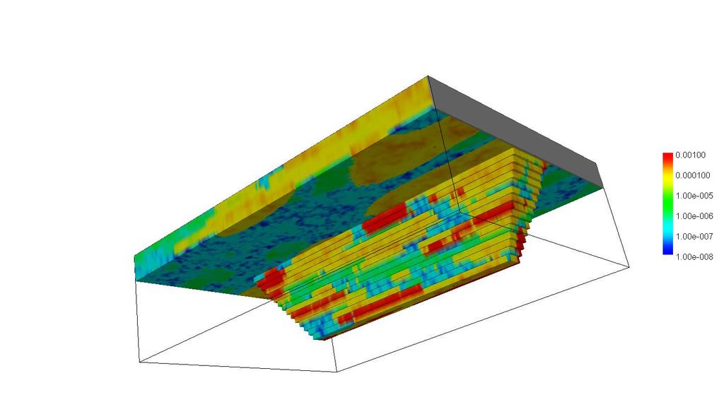
16 In practice: Build simplified model from available date e.g. borehole information Calibrate the model to fit hydrological data e.g. hydraulic head in wells Make prediction with the calibrated simplified model
17 Simple model parameters, calibration data, head and drawdown predictions Grid: 100 m 100 m 4 layers
 (Confining bed leakances not")
18 Real K field versus simple model perfectly calibrated K field (realisation 1) (Confining bed leakances not visualised)

19 Real drawdown versus simple model predicted drawdown (realisation 1)
20 Real pathline versus simple model predicted pathline (realisation 1)
21 HyGEM developments Coupled inversion Geometry: Layer interfaces and thicknesses in groundwater model and geophysical model must be identical Petrophysical: Correlation of electrical and hydraulic conductivity Sequential inversion Invert geophysical data then invert for hydrological/geological parameters Geostatistical approach Statistical links between e.g. lithology and resistivity used to build probable models
22 Coupled inversion: Geometric Groundwater model TEM model d 1,h d 1,g d 2,g d 2,h d 3,g 1 2 c ( ) 2 PCC = d - d - d s h 1, g 2, g
23 Coupled inversion: Petrophysical Groundwater model TEM model K K 2 3 PC=1/S(C+ln(K 2 )-ln( 3 )) 2
24 Clay weight Sequential inversion: SSV 1 clay transition Resistivity [ohmm] not clay

25 Sequential inversion: SSV

26 Geostatistical approach Describe relationship between lithology and resistivity GERDA and Jupiter!

27 Geostatistical links Gunnik, 2007
28 Geostatistical links
29 Geophysical data Objectives Geological data Hydrological data HyGEM Hydrological/Geological model Field scale testing!
30 HyGEM - a new Strategic Research Council project for linking geophysical models to hydrological models Anders Vest Christiansen, GEUS Esben Auken, Dept. of Geoscience, Aarhus University
INTEGRATION OF BOREHOLE INFORMATION AND RESISTIVITY DATA FOR AQUIFER VULNERABILITY
 INTEGRATION OF BOREHOLE INFORMATION AND RESISTIVITY DATA FOR AQUIFER VULNERABILITY ANDERS V. CHRISTIANSEN 1, ESBEN AUKEN 1 AND KURT SØRENSEN 1 1 HydroGeophysics Group, Aarhus University, Finlandsgade 8,
HydroGeophysics Group. HydroGeophysics Group Institute for Geoscience, Aarhus University, Denmark
 HydroGeophysics Group HydroGeophysics Group Institute for Geoscience, Aarhus University, Denmark www.hgg.au.dk www.hygem.org People in HyGEM Esben Auken, PI Jesper Pedersen, HGG, administrative services
Mini-SkyTEM: a new airborne transient EM system for near-surface aquifer mapping Cyril Schamper*, Esben Auken HydroGeophysics Group (Aarhus
 Mini-SkyTEM: a new airborne transient EM system for near-surface aquifer mapping Cyril Schamper*, Esben Auken HydroGeophysics Group (Aarhus University, Denmark) Outline I. The new Mini-SkyTEM system: AEM
Rethink GroundWater Mapping and Management Strategies for Unconventional Uydrocarbons using Airborne EM
 Rethink GroundWater Mapping and Management Strategies for Unconventional Uydrocarbons using Airborne EM Andrea Viezzoli Aarhus Geophysics Aps, Andrea.viezzoli@aarhusgeo.com Summary The need to map, extract,
GEOLOGICAL SURVEY OF DENMARK AND GREENLAND: EARLY SKETCHES FOR A DETAILED NATIONWIDE 3D GEOLOGICAL MODEL BASED ON GEOPHYSICAL DATA AND BOREHOLES
 GEOLOGICAL SURVEY OF DENMARK AND GREENLAND: EARLY SKETCHES FOR A DETAILED NATIONWIDE 3D GEOLOGICAL MODEL BASED ON GEOPHYSICAL DATA AND BOREHOLES Flemming Jørgensen, Richard Thomsen, Peter.B.E. Sandersen
Summary. Introduction. Theory and/or Method
 Case studies from Fort Mc Murray, Horn River basin and Manitoba displaying advances in technology, new approach and updated interpretation of AEM data for unconventional hydrocarbons and groundwater mapping
Mo 23P1 11 Groundbased TEM Survey in the Subsiding Mekong Delta
 Mo 23P1 11 Groundbased TEM Survey in the Subsiding Mekong Delta T. Bording* (Aarhus University), A.V. Christiansen (Aarhus University), E. Auken (Aarhus University), J.L. Gunnink (TNO), G.H.P. Oude Essink
FloaTEM mapping Sunds lake - HydroGeophysics Group - Aarhus University
 FloaTEM mapping Sunds lake - HydroGeophysics Group - Aarhus University FloaTEM Mapping Sunds lake Report number 06-11-2018, November 2018 TABLE OF CONTENTS 1. Introduction... 2 2. Data Collection... 4
Advanced processing and inversion of two AEM datasets for 3D geological modelling: the case study of Spiritwood Valley Aquifer
 Advanced processing and inversion of two AEM datasets for 3D geological modelling: the case study of Spiritwood Valley Aquifer Vincenzo Sapia, INGV, Rome, Italy Vincenzo.sapia@ingv.it Andrea Viezzoli,
Mapping the fresh-saltwater interface in the coastal zone using high-resolution airborne electromagnetics
 Mapping the fresh-saltwater interface in the coastal zone using high-resolution airborne electromagnetics Jesper B. Pedersen 1*, Frans W. Schaars 2, Anders V. Christiansen 1, Nikolaj Foged 1, Cyril Schamper
Tu Olym 01 Quantitative Depth to Bedrock Extraction from AEM Data
 Tu Olym 01 Quantitative Depth to Bedrock Extraction from AEM Data H. Anschütz (NGI), C. Christensen (Queen's University) & A.A. Pfaffhuber* (NGI) SUMMARY A new road segment is being planned northeast of
Saltwater intrusions in the low-lying coastal areas of South-Western Jutland
 Saltwater intrusions in the low-lying coastal areas of South-Western Jutland Rena Meyer* Peter Engesgaard*, Torben O. Sonnenborg^ *University of Copenhagen, Denmark ^Geological Survey of Denmark and Greenland,
Airborne Geophysics to Map Groundwater. Bill Brown
 Airborne Geophysics to Map Groundwater Bill Brown bb@skytem.com A 6 borehole represents 1 millionth of an acre Aquifer Materials An aquifer is an underground layer of water bearing permeable rock, rock
DK 1 Sunds WP 5. SUNDS - Groundwater flooding and 3D geological modelling
 SUNDS - Groundwater flooding and 3D geological modelling Sunds overview Timeline and activities 2017 2018 Workshop case at the TopSoil partner meeting i Brügge in september 2017 The Challenges + High groundwater
AIRBORNE ELECTROMAGNETIC SURVEYS FOR 3D GEOLOGICAL MAPPING
 AIRBORNE ELECTROMAGNETIC SURVEYS FOR 3D GEOLOGICAL MAPPING Jared D. Abraham 1 and James C. Cannia 2 1 United States Geological Survey, Crustal Geophysics and Geochemistry Science Center, United States
Combining airborne electromagnetics with geotechnical data for automated depth to bedrock tracking
 Combining airborne electromagnetics with geotechnical data for automated depth to bedrock tracking Craig W Christensen a,b,1, Andreas A Pfaffhuber a, Helgard Anschütz a and Tone F Smaavik a a Norwegian
Outline. Why do we need a new geophysical method? Some of the technical details. Examples
 ttem - Et nyt instrument til ekstrem detaljeret kortlægning af den overfladenære geologi til geotekniske undersøgelser, grundvandsbeskyttelse og landbrug Esben Auken, Jesper B. Pedersen, Anders V. Christiansen,
4.11 Groundwater model
 4.11 Groundwater model 4.11 Groundwater model 4.11.1 Introduction and objectives Groundwater models have the potential to make important contributions in the mapping and characterisation of buried valleys.
Redox interfaces and reduced compounds at the Lillebæk and Norsminde study areas
 Redox interfaces and reduced compounds at the Lillebæk and Norsminde study areas NiCA Technical Note October 2013 Vibeke Ernstsen Geological Survey of Denmark and Greenland G E U S Referencing this report:
WATERSHED SCALE CHARACTERIZATION OF GLACIAL AND BEDROCK AQUIFERS IN EASTERN NEBRASKA
 WATERSHED SCALE CHARACTERIZATION OF GLACIAL AND BEDROCK AQUIFERS IN EASTERN NEBRASKA Lawrence, KS May 21, 2015 Jared D. Abraham, MSc., Senior Research Geophysicist, XRI James C. Cannia, P.G., Senior Geologist,
RESISTIVITY IMAGING AND BOREHOLE INVESTIGATION OF THE BANTING AREA AQUIFER, SELANGOR, MALAYSIA. A.N. Ibrahim Z.Z.T. Harith M.N.M.
 JOURNAL OF ENVIRONMENTAL HYDROLOGY The Electronic Journal of the International Association for Environmental Hydrology On the World Wide Web at http://www.hydroweb.com VOLUME 11 2003 RESISTIVITY IMAGING
Inverting hydraulic heads in an alluvial aquifer constrained with ERT data through MPS and PPM: a case study
 Inverting hydraulic heads in an alluvial aquifer constrained with ERT data through MPS and PPM: a case study Hermans T. 1, Scheidt C. 2, Caers J. 2, Nguyen F. 1 1 University of Liege, Applied Geophysics
Accurate quasi 3D versus practical full 3D inversion of AEM data the Bookpurnong case study
 Accurate quasi 3D versus practical full 3D inversion of AEM data the Bookpurnong case study Andrea Viezzoli Andrea Viezzoli 1,5, Tim Munday 2, Esben Auken 3 and Anders V. Christiansen 4 1 Aarhus Geophysics
Istituto Nazionale di Geofisica e Vulcanologia, Rome,Italy 2. Geological Survey of Canada, Ottawa, Canada 3. Aarhus Geophysics Aps, Aarhus, Denmark
 INCORPORATING A-PRIORI INFORMATION INTO AEM INVERSION FOR GEOLOGICAL AND HYDROGEOLOGICAL MAPPING OF THE SPIRITWOOD VALLEY AQUIFER, MANITOBA, CANADA V. Sapia 1, G. Oldenborger 2 and A. Viezzoli 3 1 Istituto
Finding Large Capacity Groundwater Supplies for Irrigation
 Finding Large Capacity Groundwater Supplies for Irrigation December 14, 2012 Presented by: Michael L. Chapman, Jr., PG Irrigation Well Site Evaluation Background Investigation Identify Hydrogeologic Conditions
A NOVEL APPROACH TO GROUNDWATER MODEL DEVELOPMENT. Thomas D. Krom 1 and Richard Lane 2
 A NOVEL APPROACH TO GROUNDWATER MODEL DEVELOPMENT Thomas D. Krom 1 and Richard Lane 2 1 Touch Water Ltd., P.O. Box 143, Lincoln, Christchurch, New Zealand; email: touchwater@gmail.com 2 Applied Research
Groundwater Geophysics
 Groundwater Geophysics A Tool for Hydrogeology Bearbeitet von 2nd ed. 2008. Buch. xx, 548 S. Hardcover ISBN 978 3 540 88404 0 Format (B x L): 15,5 x 23,5 cm Gewicht: 1094 g Weitere Fachgebiete > Physik,
PETROLEUM GEOSCIENCES GEOLOGY OR GEOPHYSICS MAJOR
 PETROLEUM GEOSCIENCES GEOLOGY OR GEOPHYSICS MAJOR APPLIED GRADUATE STUDIES Geology Geophysics GEO1 Introduction to the petroleum geosciences GEO2 Seismic methods GEO3 Multi-scale geological analysis GEO4
Jesse Crews, P.G. 1 Ahmad A. Behroozmand 2 Rosemary Knight 3. Senior Geophysicist, GEM Center*, Stanford University
 Jesse Crews, P.G. 1 Ahmad A. Behroozmand 2 Rosemary Knight 3 1 Senior Geophysicist, GEM Center*, Stanford University 2 Posdoctoral Researcher, Stanford University 3 Professor of Geophysics & Director of
Analyzing the effects of geological and parameter uncertainty on prediction of groundwater head and travel time
 Model Development ess doi:10.5194/hess-17-3245-2013 Author(s) 2013. CC Attribution 3.0 License. Hydrology and Earth System Sciences Open Access Ocean Science Analyzing the effects of geological and parameter
2. REGIS II: PARAMETERIZATION OF A LAYER-BASED HYDROGEOLOGICAL MODEL
 HYDRAULIC PARAMETERIZATION OF 3D SUBSURFACE MODELS: FROM MEASUREMENT-SCALE TO MODEL-SCALE Jan L. Gunnink, Jan Stafleu, Denise Maljers and Jan Hummelman TNO Geological Survey of the Netherlands, P.O. Box
Challenges in conditioning a stochastic geological model of a heterogeneous glacial aquifer to a comprehensive soft data set
 doi:10.5194/hess-18-2907-2014 Author(s) 2014. CC Attribution 3.0 License. Challenges in conditioning a stochastic geological model of a heterogeneous glacial aquifer to a comprehensive soft data set J.
Iterative modelling of AEM data based on a priori information from seismic and borehole data
 Near Surface Geophysics, 2014, 12, xxx-xxx doi:10.3997/1873-0604.2014024 Iterative modelling of AEM data based on a priori information from seismic and borehole data Anne-Sophie Høyer 1,2, Flemming Jørgensen
Inversion of SkyTEM data over an ultramafic hosted Ni-Cu deposit in Greenland
 Inversion of SkyTEM data over an ultramafic hosted Ni-Cu deposit in Greenland John Joseph 1 and Per Gisseloe 2 1 Geophysical Consultancy Services, WA 2 SkyTEM Aps, Denmark Why Greenland Example? Survey
Large-scale TEM investigation for groundwater
 Exploration Geophysics (2003) 34, 188 194 Large-scale TEM investigation for groundwater Esben Auken 1 Flemming Jørgensen 2 Kurt I. Sørensen 3 Key Words: TEM, transient electromagnetic, buried valleys,
PRELIMINARY. Select Geophysical Methods and Groundwater Modeling: Examples from USGS studies. Claudia Faunt and a cast of others
 Select Geophysical Methods and Groundwater Modeling: Examples from USGS studies Claudia Faunt and a cast of others Current Preliminary Studies Stanford Water in the West Groundwater Data Workshop Series:
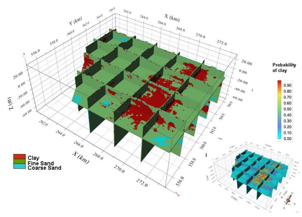
Multi-point Modeling of Clay Lenses and its Impact on Aquifer Vulnerability
 Multi-point Modeling of Clay Lenses and its Impact on Aquifer Vulnerability Whitney Trainor and Jef Caers Earth, Energy, and Environmental Sciences Stanford Center for Reservoir Forecasting April 30 &
Mutually and laterally constrained inversion of CVES and TEM data: a case study
 Near Surface Geophysics, 2007, 115-123 Mutually and laterally constrained inversion of CVES and TEM data: a case study Anders V. Christiansen *, Esben Auken, Nikolai Foged and Kurt I. Sørensen The Hydrogeophysics
Journal of Applied Geophysics
 Journal of Applied Geophysics 65 (2008) 10 20 Contents lists available at ScienceDirect Journal of Applied Geophysics journal homepage: www.elsevier.com/locate/jappgeo A resolution study of buried valleys
Training Venue and Dates Ref # Reservoir Geophysics October, 2019 $ 6,500 London
 Training Title RESERVOIR GEOPHYSICS Training Duration 5 days Training Venue and Dates Ref # Reservoir Geophysics DE035 5 07 11 October, 2019 $ 6,500 London In any of the 5 star hotels. The exact venue
Stretching AEM near-surface resolution limits related to low- and very high resistivity contrasts
 Stretching AEM near-surface resolution limits related to low- and very high resistivity contrasts 1 st G. H. Skurdal* 2 nd A. A. Pfaffhuber 3 rd A. Davis NGI NGI CSIRO Sognsv. 72, NO-8 Oslo Sognsv. 72,
Next Generation 3D Modelling & Inversion:
 Next Generation 3D Modelling & Inversion: what you don't know can help you Mark Jessell CET UWA Laurent Aillères (Monash Uni) Eric de Kemp (Geol. Survey Canada) Roland Martin (CNRS Toulouse) Mark Lindsay,
Reservoir connectivity uncertainty from stochastic seismic inversion Rémi Moyen* and Philippe M. Doyen (CGGVeritas)
") Rémi Moyen* and Philippe M. Doyen (CGGVeritas) Summary Static reservoir connectivity analysis is sometimes based on 3D facies or geobody models defined by combining well data and inverted seismic impedances.
Rémi Moyen* and Philippe M. Doyen (CGGVeritas) Summary Static reservoir connectivity analysis is sometimes based on 3D facies or geobody models defined by combining well data and inverted seismic impedances.
Recent developments in object modelling opens new era for characterization of fluvial reservoirs
 Recent developments in object modelling opens new era for characterization of fluvial reservoirs Markus L. Vevle 1*, Arne Skorstad 1 and Julie Vonnet 1 present and discuss different techniques applied
Combination of ID laterally constrained inversion and smooth inversion of resistivity data with a priori data from boreholes
 Combination of ID laterally constrained inversion and smooth inversion of resistivity data with a priori data from boreholes Wisén, Roger; Auken, E; Dahlin, Torleif Published in: Near Surface Geophysics
SEG Houston 2009 International Exposition and Annual Meeting
 The role of EM rock physics and seismic data in integrated 3D CSEM data analysis I. Brevik*, StatoilHydro, Pål T. Gabrielsen, Vestfonna and Jan Petter Morten, EMGS Summary An extensive 3D CSEM dataset
Geophysical Surveys for Groundwater Modelling of Coastal Golf Courses
 1 Geophysical Surveys for Groundwater Modelling of Coastal Golf Courses C. RICHARD BATES and RUTH ROBINSON Sedimentary Systems Research Group, University of St. Andrews, St. Andrews, Scotland Abstract
The Future of AEM. Peter Fullagar. Fullagar Geophysics Pty Ltd & Mira Geoscience. Brisbane. (Stettler, 2009)
") The Future of AEM Peter Fullagar Fullagar Geophysics Pty Ltd & Mira Geoscience Brisbane (Stettler, 2009) Acknowledgements Contributors Anglo American Exploration Niels Christensen (Aarhus University) Andrew
The Future of AEM Peter Fullagar Fullagar Geophysics Pty Ltd & Mira Geoscience Brisbane (Stettler, 2009) Acknowledgements Contributors Anglo American Exploration Niels Christensen (Aarhus University) Andrew
Tu 23P1 06 Mapping Possible Flowpaths of Contaminants through Surface and Cross-borehole Spectral Timedomain Induced Polarization
 Tu 23P1 06 Mapping Possible Flowpaths of Contaminants through Surface and Cross-borehole Spectral Timedomain Induced Polarization T. Bording* (Aarhus University), G. Fiandaca (Aarhus University), P.K.
Inverse Modelling for Flow and Transport in Porous Media
 Inverse Modelling for Flow and Transport in Porous Media Mauro Giudici 1 Dipartimento di Scienze della Terra, Sezione di Geofisica, Università degli Studi di Milano, Milano, Italy Lecture given at the
Stochastic methods for aquifer protection and management
 Stochastic methods for aquifer protection and management Dr Adrian Butler Department of Civil & Environmental Engineering G-WADI 07 International Workshop on Groundwater Modeling for Arid and Semi-arid
White Paper - SkyTEM Multi Geophysical Airborne Surveys
 White Paper - SkyTEM Multi Geophysical Airborne Surveys (TDEM / Magnetic and Gamma-Ray Spectrometry) Tomas Grand Han Limburg Bill Brown SkyTEM Surveys Medusa BV SkyTEM Surveys Denmark The Netherlands Denmark
Simultaneous use of hydrogeological and geophysical data for groundwater protection zone delineation by co-conditional stochastic simulations
 Simultaneous use of hydrogeological and geophysical data for groundwater protection zone delineation by co-conditional stochastic simulations C. Rentier,, A. Dassargues Hydrogeology Group, Departement
The mountain is permeable and fractured: Hydrological Connectivity in the Laramie Range
 WyCHEG Interest Group Meeting, Oct 30, 2017, Laramie, WY The mountain is permeable and fractured: Hydrological Connectivity in the Laramie Range Ye Zhang 1, Brad Carr 1, Shuangpo Ren 2, Andy Parsekian
ASK Network Partnership
 ASK Network Partnership Hugh Barron & Diarmad Campbell, BGS NERC All rights reserved Scottish Water, Shieldhall, 30 August 2013 What is ASK? Accessing Subsurface Knowledge..a knowledge exchange network
Geostatistics for Seismic Data Integration in Earth Models
 2003 Distinguished Instructor Short Course Distinguished Instructor Series, No. 6 sponsored by the Society of Exploration Geophysicists European Association of Geoscientists & Engineers SUB Gottingen 7
Slopes of an airborne electromagnetic resistivity model interpolated jointly with borehole data for 3D geological modelling
 Slopes of an airborne electromagnetic resistivity model interpolated jointly with borehole data for 3D geological modelling P.-A. Reninger 1, G. Martelet 1, J. Perrin 1, J. Deparis 1 and Y. Chen 2 1 Bureau
1.72, Groundwater Hydrology Prof. Charles Harvey Lecture Packet #5: Groundwater Flow Patterns. Local Flow System. Intermediate Flow System
 1.72, Groundwater Hydrology Prof. Charles Harvey Lecture Packet #5: Groundwater Flow Patterns c Local Flow System 10,000 feet Intermediate Flow System Regional Flow System 20,000 feet Hydrologic section
2017 Fowler Domain & Western Gawler Craton SkyTEM 312 AEM Survey, South Australia
 2017 Fowler Domain & Western Gawler Craton SkyTEM 312 AEM Survey, South Australia Geoscience Australia & the Geological Survey of South Australia D.J McInnes Geoscience Australia ecat ID 121550 Department
11/22/2010. Groundwater in Unconsolidated Deposits. Alluvial (fluvial) deposits. - consist of gravel, sand, silt and clay
 deposits. - consist of gravel, sand, silt and clay") Groundwater in Unconsolidated Deposits Alluvial (fluvial) deposits - consist of gravel, sand, silt and clay - laid down by physical processes in rivers and flood plains - major sources for water supplies
Groundwater in Unconsolidated Deposits Alluvial (fluvial) deposits - consist of gravel, sand, silt and clay - laid down by physical processes in rivers and flood plains - major sources for water supplies
Assessment of Hydraulic Conductivity Upscaling Techniques and. Associated Uncertainty
 CMWRXVI Assessment of Hydraulic Conductivity Upscaling Techniques and Associated Uncertainty FARAG BOTROS,, 4, AHMED HASSAN 3, 4, AND GREG POHLL Division of Hydrologic Sciences, University of Nevada, Reno
Electrical imaging techniques for hydrological and risk assessment studies
 Séminaire IPG le 9 mars 2006 Strasbourg Institute of Geophysics ETH Hoenggerberg CH-8093 Zurich Electrical imaging techniques for hydrological and risk assessment studies Laurent Marescot laurent@aug.ig.erdw.ethz.ch
Ensemble Kalman filter assimilation of transient groundwater flow data via stochastic moment equations
 Ensemble Kalman filter assimilation of transient groundwater flow data via stochastic moment equations Alberto Guadagnini (1,), Marco Panzeri (1), Monica Riva (1,), Shlomo P. Neuman () (1) Department of
Geophysical Characterization and Monitoring of Groundwater/Surface-Water Interaction in the Hyporheic Corridor at the Hanford 300 Area
 Geophysical Characterization and Monitoring of Groundwater/Surface-Water Interaction in the Hyporheic Corridor at the Hanford 300 Area L. Slater 1, F. Day-Lewis 2, R. Versteeg 3, A. Ward 4, J. Lane 2,
Quantitative Seismic Interpretation An Earth Modeling Perspective
 Quantitative Seismic Interpretation An Earth Modeling Perspective Damien Thenin*, RPS, Calgary, AB, Canada TheninD@rpsgroup.com Ron Larson, RPS, Calgary, AB, Canada LarsonR@rpsgroup.com Summary Earth models
The Transient Electromagnetic (TEM) Method, sometimes referred to as Time domain EM (TDEM)
 Method, sometimes referred to as Time domain EM (TDEM)") The Transient Electromagnetic (TEM) Method, sometimes referred to as Time domain EM (TDEM) From diffusion to wave E z, 100 ohm-m, K=30 Induction (EM, MT) Wave (GPR) The basics Primary field Secondary field
The Transient Electromagnetic (TEM) Method, sometimes referred to as Time domain EM (TDEM) From diffusion to wave E z, 100 ohm-m, K=30 Induction (EM, MT) Wave (GPR) The basics Primary field Secondary field
Downloaded 10/25/16 to Redistribution subject to SEG license or copyright; see Terms of Use at
 Facies modeling in unconventional reservoirs using seismic derived facies probabilities Reinaldo J. Michelena*, Omar G. Angola, and Kevin S. Godbey, ireservoir.com, Inc. Summary We present in this paper
ractical Geomechanics for Oil & Gas Industry
 P ractical Geomechanics for Oil & Gas Industry Practical Geomechanics for Oil and Gas Industry The integrity of the wellbore plays an important role in petroleum operations including drilling, completion
- Cased-hole geophysical well logs - Airborne geophysics - Seismic data - LiDAR. GeoConvention 2015: New Horizons 1
 Thermal Effects and Quaternary Hydrogeology: Making Good Decisions in a Complex Geologic Setting Timothy Johnsen, Phd, Quaternary Specialist (tjohnsen@matrix-solutions.com) Alex Haluszka, MSc, P.Geol.,
Case Study: University of Connecticut (UConn) Landfill
 Landfill") Case Study: University of Connecticut (UConn) Landfill Problem Statement:» Locate disposal trenches» Identify geologic features and distinguish them from leachate and locate preferential pathways in fractured
Case Study: University of Connecticut (UConn) Landfill Problem Statement:» Locate disposal trenches» Identify geologic features and distinguish them from leachate and locate preferential pathways in fractured
Seismic Reservoir Characterization of the Low Porosity and Permeability Reservoir
 Seismic Reservoir Characterization of the Low Porosity and Permeability Reservoir A Case Study outside Daqing Oilfield, China Qi Xu 1, Yonggui Guo 1, Yujin Zhang 2 *, Sihan Li 1, FeiFei Zhang 1, Junxia
Delineation of Zones at Risk from Groundwater Inflows at an Underground Platinum Mine in South Africa
 Delineation of Zones at Risk from Groundwater Inflows at an Underground Platinum Mine in South Africa Mr Andreas Stoll andreas.stoll@erm.com Environmental Resources Management Swiss GmbH (ERM), Switzerland
Technical Requirements of Geothermal Exploration in the RSM DADI THORBJORNSON, RSM CONSULTANT WORKSHOP SWISS HOTEL IZMIR 5 JULY 2018
 Technical Requirements of Geothermal Exploration in the RSM DADI THORBJORNSON, RSM CONSULTANT WORKSHOP SWISS HOTEL IZMIR 5 JULY 2018 JV Partners Engineering firm with hundred twenty years of experience
Geophysics and Geothermal Energy. Joseph Capriotti Meghan Helper Kendra Johnson Patricia Littman Gordon Osterman
 Geophysics and Geothermal Energy Joseph Capriotti Meghan Helper Kendra Johnson Patricia Littman Gordon Osterman Colorado School of Mines End of students junior year 4 week field camp Learning experience
Quantitative Interpretation
 Quantitative Interpretation The aim of quantitative interpretation (QI) is, through the use of amplitude analysis, to predict lithology and fluid content away from the well bore. This process should make
Groundwater Sustainability at Wadi Al Bih Dam, Ras El Khaimah, United Arab Emirates (UAE) using Geophysical methods
 using Geophysical methods") Groundwater Sustainability at Wadi Al Bih Dam, Ras El Khaimah, United Arab Emirates (UAE) using Geophysical methods Ahmed Murad, Amir Gabr, Saber Mahmoud, Hasan Arman & Abdulla Al Dhuhoori Geology Department
Groundwater Sustainability at Wadi Al Bih Dam, Ras El Khaimah, United Arab Emirates (UAE) using Geophysical methods Ahmed Murad, Amir Gabr, Saber Mahmoud, Hasan Arman & Abdulla Al Dhuhoori Geology Department
Geophysics and Mapping. presented by: Stephen Brown
 Geophysics and Mapping presented by: Stephen Brown Recommended book for INIGEMM Geophysics for the mineral exploration geoscientist, by Michael Dentith and Stephen Mudge, Cambridge University Press, 2014.
Log Interpretation in Non-Hydrocarbon Environments - Methods and Applications -
 ICDP International Continental Drilling Program Log Interpretation in Non-Hydrocarbon Environments - Methods and Applications - Dr. Renate Pechnig Aachen University of Technology Log data for lithology
Hannover
 BURVAL 3 FINAL CONFERENCE AND WORKSHOP F E at GEOZENTRUM 4 Hannover 2006.11.29-30 2 D 7 5 A B C 9 Office of Partner 6 1 8 1 (LP)GGA-Institut 2 Vejle Amt 3 Ringkjøbing Amt 4 Sønderjyllands Amt 5 GEUS 6
Comparison of Fixed-Wing Airborne Electromagnetic 1D inversion methods
 Geophysical Inversion and Modeling Paper 96 Comparison of Fixed-Wing Airborne Electromagnetic 1D inversion methods Vallée, M. A. [1], Smith, R. S. [1] 1. Fugro Airborne Surveys Corp., 2191 Thurston Drive,
Lithium Brines: What can we learn from established brine production regions?
 Lithium Brines: What can we learn from established brine production regions? An Overview Of Lithium Brine Exploration for Resource Estimation Camilo de los Hoyos Ph.D, Senior Consultant (Geochemistry &
FUNDAMENTALS OF SEISMIC EXPLORATION FOR HYDROCARBON
 FUNDAMENTALS OF SEISMIC EXPLORATION FOR HYDROCARBON Instructor : Kumar Ramachandran 10 14 July 2017 Jakarta The course is aimed at teaching the physical concepts involved in the application of seismic
Using groundwater-flow model results to evaluate a useful 3-D GFM mapping scale
 Topography Geology Hydrology Using groundwater-flow model results to evaluate a useful 3-D GFM mapping scale Sally L. Letsinger, Ph.D., LPG, GISP IU Center for Geospatial Data Analysis, Indiana Geological
DATA ACQUISITION METHODS FOR GROUNDWATER INVESTIGATION AND THE SITING OF WATER SUPPLY WELLS
 DATA ACQUISITION METHODS FOR GROUNDWATER INVESTIGATION AND THE SITING OF WATER SUPPLY WELLS M.B.J. Foster Tetra Tech EM Inc., San Francisco, CA, USA Keywords: Groundwater, water wells, drilled wells, geophysical
Integration of Rock Physics Models in a Geostatistical Seismic Inversion for Reservoir Rock Properties
 Integration of Rock Physics Models in a Geostatistical Seismic Inversion for Reservoir Rock Properties Amaro C. 1 Abstract: The main goal of reservoir modeling and characterization is the inference of
Resolution analyses for selecting an appropriate airborne electromagnetic (AEM) system
 system") CSIRO PUBLISHING Exploration Geophysics, 12, 43, 213 227 http://dx.doi.org/1.171/eg15 Resolution analyses for selecting an appropriate airborne electromagnetic (AEM) system Niels B. Christensen 1,3 Ken
CSIRO PUBLISHING Exploration Geophysics, 12, 43, 213 227 http://dx.doi.org/1.171/eg15 Resolution analyses for selecting an appropriate airborne electromagnetic (AEM) system Niels B. Christensen 1,3 Ken
23855 Rock Physics Constraints on Seismic Inversion
 23855 Rock Physics Constraints on Seismic Inversion M. Sams* (Ikon Science Ltd) & D. Saussus (Ikon Science) SUMMARY Seismic data are bandlimited, offset limited and noisy. Consequently interpretation of
Oak Ridge IFRC. Quantification of Plume-Scale Flow Architecture and Recharge Processes
 Oak Ridge IFRC Quantification of Plume-Scale Flow Architecture and Recharge Processes S. Hubbard *1, G.S. Baker *2, D. Watson *3, D. Gaines *3, J. Chen *1, M. Kowalsky *1, E. Gasperikova *1, B. Spalding
Hydraulic tomography: Development of a new aquifer test method
 WATER RESOURCES RESEARCH, VOL. 36, NO. 8, PAGES 2095 2105, AUGUST 2000 Hydraulic tomography: Development of a new aquifer test method T.-C. Jim Yeh and Shuyun Liu Department of Hydrology and Water Resources,
Visualising time-series data with the Australian Hydrological Geospatial Fabric & the Geofabric Sample Toolbox
 Visualising time-series data with the Australian Hydrological Geospatial Fabric & the Geofabric Sample Toolbox Darren G Smith #Locate15, Thursday 12 th of March 2015 Presentation outline Quick background
Applying Stimulation Technology to Improve Production in Mature Assets. Society of Petroleum Engineers
 Applying Stimulation Technology to Improve Production in Mature Assets Alexandr Mocanu Well Production Services, Schlumberger Visegrád, 19 November 2015 Society of Petroleum Engineers 1 Agenda Formation
Mathematical model of Baltic artesian basin
 Mathematical model of Baltic artesian basin Juris Sennikovs, Janis Virbulis, and Uldis Bethers Laboratory for Mathematical Modelling of Environmental and Technological Processes UNIVERSITY OF LATVIA Contents
RESISTIVITY IMAGING IN EASTERN NEVADA USING THE AUDIOMAGNETOTELLURIC METHOD FOR HYDROGEOLOGIC FRAMEWORK STUDIES. Abstract.
 RESISTIVITY IMAGING IN EASTERN NEVADA USING THE AUDIOMAGNETOTELLURIC METHOD FOR HYDROGEOLOGIC FRAMEWORK STUDIES Darcy K. McPhee, U.S. Geological Survey, Menlo Park, CA Louise Pellerin, Green Engineering,
Integrated inversion of TEM and seismic data facilitated by high penetration depths of a segmented receiver setup
 Near Surface Geophysics, 2010, 8, 467-473 doi:10.3997/1873-0604.2010026 Integrated inversion of TEM and seismic data facilitated by high penetration depths of a segmented receiver setup Nicklas S. Nyboe
Underground nuclear waste storage
 Underground nuclear waste storage Groundwater flow and radionuclide transport Jan-Olof Selroos Cargese Summer School, July 5, 2018 Contents: Concept for geological disposal of nuclear waste A few words
Field Geologists' Manual. AuslfTlfT) Monograph 9 FIFTH EDITION THG MINERALS INSTITUTE. Published by:
 Monograph 9 FIFTH EDITION THG MINERALS INSTITUTE. Published by:") Field Geologists' Manual FIFTH EDITION Monograph 9 AuslfTlfT) THG MINERALS INSTITUTE Published by: THE AUSTRALASIAN INSTITUTE OF MINING AND METALLURGY Ground Floor, 204 Lygon Street, Carlton Victoria 3053
Field Geologists' Manual FIFTH EDITION Monograph 9 AuslfTlfT) THG MINERALS INSTITUTE Published by: THE AUSTRALASIAN INSTITUTE OF MINING AND METALLURGY Ground Floor, 204 Lygon Street, Carlton Victoria 3053
Geotechnical modelling based on geophysical logging data
 University of Wollongong Research Online Coal Operators' Conference Faculty of Engineering and Information Sciences 2013 Geotechnical modelling based on geophysical logging data Peter Hatherly Coalbed
A. Baiocchi 1, W. Dragoni 2, F. Lotti 1, S.M. Piacentini 2, V. Piscopo 1
 A. Baiocchi 1, W. Dragoni 2, F. Lotti 1, S.M. Piacentini 2, V. Piscopo 1 (1) Department of Ecological and Biological Sciences, University of Tuscia, Viterbo, Italy (2) Department of Physics and Geology,
Man, Machine and Data: A Mineral Exploration Perspective
 Man, Machine and Data: A Mineral Exploration Perspective Eun-Jung Holden, Geodata Algorithms Team The Centre for Exploration Targeting, School of Earth Sciences The University of Western Australia Team
HampsonRussell. A comprehensive suite of reservoir characterization tools. cgg.com/geosoftware
 HampsonRussell A comprehensive suite of reservoir characterization tools cgg.com/geosoftware HampsonRussell Software World-class geophysical interpretation HampsonRussell Software is a comprehensive suite