Saltwater intrusions in the low-lying coastal areas of South-Western Jutland
|
|
|
- Coleen Fitzgerald
- 5 years ago
- Views:
Transcription

1 Saltwater intrusions in the low-lying coastal areas of South-Western Jutland Rena Meyer* Peter Engesgaard*, Torben O. Sonnenborg^ *University of Copenhagen, Denmark ^Geological Survey of Denmark and Greenland, Denmark Danish Water Forum 30 th January 2017

2 Introduction SWI Processes Werner et al. (2013)

3 Introduction Challenges Is the system in steady state? How will it develop in the future? Initial salt content Coastal geology, topography?? DWI 30 th January 2017 Rena Meyer modified after Fergusson & Gleeson (2012)

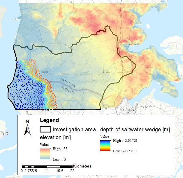
4 Study Area

) DWI 30 th January 2017 Rena Meyer reme@ign.ku.")
5 Features of the study area: Geology Characteristics: Low lying coastal area, even below sea level Heterogeneous geology + buried valleys Geological model spanning Miocene to postglacial deposits Conceptual model of the geological setting (Jørgensen et al. (2014)) DWI 30 th January 2017 Rena Meyer reme@ign.ku.dk DWI 30 th January 2017 Rena Meyer reme@ign.ku.dk
6 Modelling approach 1300km2 Heterogeneous Voxel 100x100x5m Geology MODLFOW MODPATH Steady state 1.2 mio cells Multiple objective Regularizatio n Pest calibration of 51 parameters 3D SEAWAT Salt concentration Stage 1 Stage 2 Stage 3 Validation Geophysical (AEM)


7 Flow & Transport model Geological sections through model domain with interpolated geology Grid specifications: 1.2 mio cells Δx, Δy= m, Δz=5-10m 46 hydrofacies -95m to -100 Postglacial Quarternary Miocene DWI 30 th January 2017 Rena Meyer


8 Flow & Transport model Boundary conditions RCH m/d Boundary conditions: River, drain, recharge, abstraction wells Density-corrected constant head & conc. at the Western coast No flow to the East Quarternary sand & clay W: Coast Density-corrected constant head Constant concentration 35 kg/m 3 W Recharge: Constant concentration 0.1kg/m 3 E: Water divide No flow E Miocene sand & clay No flow = top of Palaeogene

9 Flow & Transport model Observations Heads: 1100 Discharge: 3 stations C-14 ages : 18 samples, 6 locations, different depth, Quarternary & Miocene aquifers Corrected for dissolution and diffusion Wide range of groundwater ages (hundreds to almost years)
![Simulated discharge 10 3 [m 3 /d] Simulated Modpath ages [years] Simulated head [m] Flow model Results GEUS seminar 25 th January 2017 45 35 25 15 5-5 700 600 500 400 300 200 100 0-5 5 15 25](/docs-images/82/87019493/images/10-1.jpg "35 45 Observed head [m] RMS=70m 3 /d 0 100 200 300 400 500 600 700 Observed discharge 10 3 [m 3 /d] 10000 1000 100 RMS=1.55m RMS=2.")
10 Simulated discharge 10 3 [m 3 /d] Simulated Modpath ages [years] Simulated head [m] Flow model Results GEUS seminar 25 th January Observed head [m] RMS=70m 3 /d Observed discharge 10 3 [m 3 /d] RMS=1.55m RMS=2.5ka Rena Meyer Corrected 14 C ages [years]


 200-0a BP:")

11 SEAWAT model Results Saltwater intrusion for 3 stages: a BP: sea level 0m a BP: temporary transgression (sea level +2m) 200-0a BP: dyke protecting areas below sea level (sea level 0m) Salt kg/m 3


12 Validation Comparison to AEM Simulated saltwater wedge compared to saltwater/freshwater interface delineated from AEM
13 Conclusion Regional saltwater intrusion model: high resolution, complex heterogeneous geology Flow model fits the observed data well 3 stages simulations: Importance of coastal geology Freshening is still going on steady state is not yet reached Simulated saltwater intrusion fits with observed saltwater/freshwater interface (AEM) Model could be used as a tool to investigate changing conditions on a regional scale DWI 30 th January 2017 Rena Meyer reme@ign.ku.dk

14 Thank you for your attention GEUS seminar 25 th January 2017 Rena Meyer
4.11 Groundwater model
 4.11 Groundwater model 4.11 Groundwater model 4.11.1 Introduction and objectives Groundwater models have the potential to make important contributions in the mapping and characterisation of buried valleys.
Impact of the Danube River on the groundwater dynamics in the Kozloduy Lowland
 GEOLOGICA BALCANICA, 46 (2), Sofia, Nov. 2017, pp. 33 39. Impact of the Danube River on the groundwater dynamics in the Kozloduy Lowland Peter Gerginov Geological Institute, Bulgarian Academy of Sciences,
A NOVEL APPROACH TO GROUNDWATER MODEL DEVELOPMENT. Thomas D. Krom 1 and Richard Lane 2
 A NOVEL APPROACH TO GROUNDWATER MODEL DEVELOPMENT Thomas D. Krom 1 and Richard Lane 2 1 Touch Water Ltd., P.O. Box 143, Lincoln, Christchurch, New Zealand; email: touchwater@gmail.com 2 Applied Research
GEOLOGICAL SURVEY OF DENMARK AND GREENLAND: EARLY SKETCHES FOR A DETAILED NATIONWIDE 3D GEOLOGICAL MODEL BASED ON GEOPHYSICAL DATA AND BOREHOLES
 GEOLOGICAL SURVEY OF DENMARK AND GREENLAND: EARLY SKETCHES FOR A DETAILED NATIONWIDE 3D GEOLOGICAL MODEL BASED ON GEOPHYSICAL DATA AND BOREHOLES Flemming Jørgensen, Richard Thomsen, Peter.B.E. Sandersen
Advanced processing and inversion of two AEM datasets for 3D geological modelling: the case study of Spiritwood Valley Aquifer
 Advanced processing and inversion of two AEM datasets for 3D geological modelling: the case study of Spiritwood Valley Aquifer Vincenzo Sapia, INGV, Rome, Italy Vincenzo.sapia@ingv.it Andrea Viezzoli,
Mini-SkyTEM: a new airborne transient EM system for near-surface aquifer mapping Cyril Schamper*, Esben Auken HydroGeophysics Group (Aarhus
 Mini-SkyTEM: a new airborne transient EM system for near-surface aquifer mapping Cyril Schamper*, Esben Auken HydroGeophysics Group (Aarhus University, Denmark) Outline I. The new Mini-SkyTEM system: AEM
HyGEM - a new Strategic Research Council project for linking geophysical models to hydrological models
 HyGEM - a new Strategic Research Council project for linking geophysical models to hydrological models Anders Vest Christiansen, GEUS Esben Auken, Dept. of Geoscience, Aarhus University HyGEM Integrating
Chapter 8 Fetter, Applied Hydrology 4 th Edition, Geology of Groundwater Occurrence
 Chapter 8 Fetter, Applied Hydrology 4 th Edition, 2001 Geology of Groundwater Occurrence Figure 8.42. Alluvial Valleys ground-water region. Fetter, Applied Hydrology 4 th Edition, 2001 Fetter, Applied
Analyzing the effects of geological and parameter uncertainty on prediction of groundwater head and travel time
 Model Development ess doi:10.5194/hess-17-3245-2013 Author(s) 2013. CC Attribution 3.0 License. Hydrology and Earth System Sciences Open Access Ocean Science Analyzing the effects of geological and parameter
MODELING THE SALTWATER INTRUSION PHENOMENON IN COASTAL AQUIFERS - A CASE STUDY IN THE INDUSTRIAL ZONE OF HERAKLEIO IN CRETE
 Global NEST Journal, Vol. 7, No 2, pp 197-203, 2005 Copyright 2005 Global NEST Printed in Greece. All rights reserved MODELING THE SALTWATER INTRUSION PHENOMENON IN COASTAL AQUIFERS - A CASE STUDY IN THE
Mapping the fresh-saltwater interface in the coastal zone using high-resolution airborne electromagnetics
 Mapping the fresh-saltwater interface in the coastal zone using high-resolution airborne electromagnetics Jesper B. Pedersen 1*, Frans W. Schaars 2, Anders V. Christiansen 1, Nikolaj Foged 1, Cyril Schamper
1.72, Groundwater Hydrology Prof. Charles Harvey Lecture Packet #5: Groundwater Flow Patterns. Local Flow System. Intermediate Flow System
 1.72, Groundwater Hydrology Prof. Charles Harvey Lecture Packet #5: Groundwater Flow Patterns c Local Flow System 10,000 feet Intermediate Flow System Regional Flow System 20,000 feet Hydrologic section
The Saltwater Intrusion Problem: Concepts, Challenges, Modeling, Experiments and Case Studies
 The Saltwater Intrusion Problem: Concepts, Challenges, Modeling, Experiments and Case Studies Manfred Koch Department of Geohydraulics and Engineering Hydrology, University of Kassel, Germany Email: kochm@uni-kassel.de
Geophysical Surveys for Groundwater Modelling of Coastal Golf Courses
 1 Geophysical Surveys for Groundwater Modelling of Coastal Golf Courses C. RICHARD BATES and RUTH ROBINSON Sedimentary Systems Research Group, University of St. Andrews, St. Andrews, Scotland Abstract
Summary. Introduction. Theory and/or Method
 Case studies from Fort Mc Murray, Horn River basin and Manitoba displaying advances in technology, new approach and updated interpretation of AEM data for unconventional hydrocarbons and groundwater mapping
11/22/2010. Groundwater in Unconsolidated Deposits. Alluvial (fluvial) deposits. - consist of gravel, sand, silt and clay
 deposits. - consist of gravel, sand, silt and clay") Groundwater in Unconsolidated Deposits Alluvial (fluvial) deposits - consist of gravel, sand, silt and clay - laid down by physical processes in rivers and flood plains - major sources for water supplies
Groundwater in Unconsolidated Deposits Alluvial (fluvial) deposits - consist of gravel, sand, silt and clay - laid down by physical processes in rivers and flood plains - major sources for water supplies
Mark S. Nordberg Geology and Groundwater Investigations Section North Central Region Office California Department of Water Resources
 Mark S. Nordberg Geology and Groundwater Investigations Section North Central Region Office California Department of Water Resources Ukiah Drought Workshop July 29, 2009 Groundwater 101 Groundwater is
Soils, Hydrogeology, and Aquifer Properties. Philip B. Bedient 2006 Rice University
 Soils, Hydrogeology, and Aquifer Properties Philip B. Bedient 2006 Rice University Charbeneau, 2000. Basin Hydrologic Cycle Global Water Supply Distribution 3% of earth s water is fresh - 97% oceans 1%
Groundwater Sequence Stratigraphy:
 Groundwater Sequence Stratigraphy: A Geology-based Approach for Developing Accurate and Representative Hydrogeologic Conceptual Models for Successful Groundwater Sustainability Plans Rick Cramer, Burns
PRELIMINARY. Select Geophysical Methods and Groundwater Modeling: Examples from USGS studies. Claudia Faunt and a cast of others
 Select Geophysical Methods and Groundwater Modeling: Examples from USGS studies Claudia Faunt and a cast of others Current Preliminary Studies Stanford Water in the West Groundwater Data Workshop Series:
Major groundwater reservoir nr 112 in the coast of Gdańsk Bay
 Major groundwater reservoir nr 112 in the coast of Gdańsk Bay Zbigniew Kordalski 1, Andrzej Sadurski 2 Marine Branch of Polish Geological Institute NRI, 5 Kościerska str., 80-328 Gdańsk, Poland ABSTRACT
G. Barrocu G. Ranieri Faculty of Engineering, University of Cagliari, Italy. In the region of Muravera, south-east coast of Sardinia, the trend of
 HYDROGEOLOGICAL AND GEOPHYSICAL INVESTIGATIONS FOR EVALUATING SALT INTRUSION PHENOMENA IN SARDINIA G. Barbieri G. Barrocu G. Ranieri Faculty of Engineering, University of Cagliari, Italy Abstract In the
Shallow Karst Aquifer System of the Lake Belt Study Area, Miami-Dade County, Florida, USA EXTENDED ABSTRACT
 Second International Conference on Saltwater Intrusion and Coastal Aquifers Monitoring, Modeling, and Management. Merida, Mexico, March 30 April 2, 2003 Shallow Karst Aquifer System of the Lake Belt Study
Assessment of climate change impacts on salinity intrusion in Hong-Thai Binh and Dong Nai river basins
 VNU Journal of Science, Earth Sciences 27 (2011) 54-61 Assessment of climate change impacts on salinity intrusion in Hong-Thai Binh and Dong Nai river basins Tran Hong Thai, Tran Thi Van* Vietnam Institute
Electrical Resistivity Survey for Delineating Seawater Intrusion in a Coastal Aquifer
 Electrical Resistivity Survey for Delineating Seawater Intrusion in a Coastal Aquifer Sung-Ho Song*, Gyu-Sang Lee*, Jin-Sung Kim*, Baekuk Seong*, Young-gyu Kim*, Myung-Ha Woo* and Namsik Park** Abstract
Mo 23P1 11 Groundbased TEM Survey in the Subsiding Mekong Delta
 Mo 23P1 11 Groundbased TEM Survey in the Subsiding Mekong Delta T. Bording* (Aarhus University), A.V. Christiansen (Aarhus University), E. Auken (Aarhus University), J.L. Gunnink (TNO), G.H.P. Oude Essink
IPMO2-1. Groundwater Modelling of Chiang Rai Basin, Northern Thailand. Sattaya Intanum* Dr.Schradh Saenton**
 IPMO2-1 Groundwater Modelling of Chiang Rai Basin, Northern Thailand Sattaya Intanum* Dr.Schradh Saenton** ABSTRACT Chiang Rai basin, situated in Chiang Rai and Phayao provinces covering an area of 11,000
Evaluation of the hydraulic gradient at an island for low-level nuclear waste disposal
 A New Focus on Groundwater Seawater Interactions (Proceedings of Symposium HS1001 at IUGG2007, Perugia, July 2007). IAHS Publ. 312, 2007. 237 Evaluation of the hydraulic gradient at an island for low-level
DK 1 Sunds WP 5. SUNDS - Groundwater flooding and 3D geological modelling
 SUNDS - Groundwater flooding and 3D geological modelling Sunds overview Timeline and activities 2017 2018 Workshop case at the TopSoil partner meeting i Brügge in september 2017 The Challenges + High groundwater
The Detection of Sea Water Intrusion Based on Resistivity Data in the Northern City of Semarang
 International Journal of Innovative Research in Advanced Engineering (IJIRAE) ISSN: 349-163 The Detection of Sea Water Intrusion Based on Resistivity Data in the Northern City of Semarang Muhammad Ulin
Characterization of freshwater lenses for construction of groundwater flow models on two sandy barrier islands, Florida, USA
 First International Conference on Saltwater Intrusion and Coastal Aquifers Monitoring, Modeling, and Management. Essaouira, Morocco, April 23 25, 2001 Characterization of freshwater lenses for construction
A. Baiocchi 1, W. Dragoni 2, F. Lotti 1, S.M. Piacentini 2, V. Piscopo 1
 A. Baiocchi 1, W. Dragoni 2, F. Lotti 1, S.M. Piacentini 2, V. Piscopo 1 (1) Department of Ecological and Biological Sciences, University of Tuscia, Viterbo, Italy (2) Department of Physics and Geology,
Hydrogeology of Karst NE Wisconsin. Dr. Maureen A. Muldoon UW-Oshkosh Geology Department
 Hydrogeology of Karst NE Wisconsin Dr. Maureen A. Muldoon UW-Oshkosh Geology Department WI Bedrock Outline Karst Landscapes Existing WQ Data Flow in Karst Aquifers Overview of Silurian Aquifer Water Level
Application of multiple-point geostatistics on modelling groundwater flow and transport in the Brussels Sands
 Application of multiple-point geostatistics on modelling groundwater flow and transport in the Brussels Sands Marijke Huysmans (1) and Alain Dassargues (1,2) (1) Earth and Environmental Sciences, K.U.Leuven,
Springshed Springshed Management Training Curriculum
 Springshed Springshed Management Training Curriculum Management Training Curriculum Draft Version 2 January 2016 The Springs Initiative 2016 The Springs Initiative SESSION TITLE: Section Mapping SECTION:
Saltwater injection into a fractured aquifer: A density-coupled mass-transport model
 Saltwater injection into a fractured aquifer: A density-coupled mass-transport model Junfeng Luo 1, Martina aus der Beek 2, Joachim Plümacher 2, Sven Seifert 1, Bertram Monninkhoff 1 1 DHI-WASY GmbH, Volmerstr.
Mathematical model of Baltic artesian basin
 Mathematical model of Baltic artesian basin Juris Sennikovs, Janis Virbulis, and Uldis Bethers Laboratory for Mathematical Modelling of Environmental and Technological Processes UNIVERSITY OF LATVIA Contents
CHAPTER 9 SUMMARY AND CONCLUSIONS
 CHAPTER 9 SUMMARY AND CONCLUSIONS The following are the important conclusions and salient features of the present study. 1. The evaluation of groundwater potential is a prerequisite for any kind of planning
Hydrogeology and Simulated Effects of Future Water Use and Drought in the North Fork Red River Alluvial Aquifer: Progress Report
 Hydrogeology and Simulated Effects of Future Water Use and Drought in the North Fork Red River Alluvial Aquifer: Progress Report Developed in partnership with the Oklahoma Water Resources Board S. Jerrod
HYDROGEOLOGIC FRAMEWORK OF LONG ISLAND'S NORTH FORK, SUFFOLK COUNTY, NEW YORK
 HYDROGEOLOGIC FRAMEWORK OF LONG ISLAND'S NORTH FORK, SUFFOLK COUNTY, NEW YORK Christopher E. Schubert 1, Richard E. Bova 2, and Paul E. Misut 1 1 U.S. Geological Survey, 2045 Route 112, Building 4, Coram,
HOW DOES AQUIFER CONNECTIVITY IMPACT GROUNDWATER FLOW TO THE SEA AND SUBSURFACE PATTERNS OF SALINITY? Kaileigh C. Calhoun
 HOW DOES AQUIFER CONNECTIVITY IMPACT GROUNDWATER FLOW TO THE SEA AND SUBSURFACE PATTERNS OF SALINITY? by Kaileigh C. Calhoun A thesis submitted to the Faculty of the University of Delaware in partial fulfillment
A national 3D geological model of Denmark: Condensing more than 125 years of geological mapping
 A national 3D geological model of Denmark: Condensing more than 125 years of geological mapping Peter B.E. Sandersen Thomas Vangkilde-Pedersen Geological Survey of Denmark and Greenland Flemming Jørgensen
Buried-valley Aquifers: Delineation and Characterization from Reflection Seismic and Core Data at Caledon East, Ontario
 Buried-valley Aquifers: Delineation and Characterization from Reflection Seismic and Core Data at Caledon East, Ontario Russell, H.A.J. 1, S.E. Pullan 1, J.A. Hunter 1, D.R. Sharpe 1, and S. Holysh 2 1
Senior Thesis. BY Calliope A. Voiklis 2000
 Senior Thesis MODFLOW Model of The Ohio State University, Columbus Campus BY Calliope A. Voiklis 2000 Submitted as partial fulfillment of The requirements of the degree of Bachelor of Science in Geological
ambiguity in earth sciences IESO Geophysics Section Eddy hartantyo, Lab Geofisika FMIPA UGM
 ambiguity in earth sciences IESO Geophysics Section Eddy hartantyo, Lab Geofisika FMIPA UGM Pelatihan Tahap II IESO Teknik Geologi UGM Februari 2009 1 Introduction Photos from http://www.eegs.org/whatis/
Journal of Coastal Development ISSN : GEOELECTRICAL RESISTIVITY METHOD FOR SALT/BRACKISH WATER MAPPING
 Original Paper GEOELECTRICAL RESISTIVITY METHOD FOR SALT/BRACKISH WATER MAPPING Nur Islami Physic Study Program, FKIP, Riau University, Jalan Bina Widya, Panam, Pekanbaru Riau, Indonesia Received : February,
EVALUATION OF THE DOWNWARD MIGRATION OF SALTWATER TO THE UPPER FLORIDAN AQUIFER IN THE SAVANNAH, GEORGIA, AND HILTON HEAD ISLAND, SOUTH CAROLINA, AREA
 EVALUATION OF THE DOWNWARD MIGRATION OF SALTWATER TO THE UPPER FLORIDAN AQUIFER IN THE SAVANNAH, GEORGIA, AND HILTON HEAD ISLAND, SOUTH CAROLINA, AREA Camille Ransom, III 1, James E. Landmeyer 2, W. Robert
Multi-scale evaluations of submarine groundwater discharge
 doi:10.5194/piahs-365-66-2015 66 Complex Interfaces Under Change: Sea River Groundwater Lake Proceedings of HP2/HP3, IAHS-IAPSO-IASPEI Assembly, Gothenburg, Sweden, July 2013 (IAHS Publ. 365, 2014). Multi-scale
A~3000 years-old sequence of extreme revealed by marine and shore deposits east of Taiwan Serge Lallemand, Remi Lehu, Fabien Retif, Shu-Kun Hsu,
 A~3000 years-old sequence of extreme revealed by marine and shore deposits east of Taiwan Serge Lallemand, Remi Lehu, Fabien Retif, Shu-Kun Hsu, Nathalie Babonneau, Gueorgui Ratzov, Maria-Angella Basseti,
ON THE EVOLUTION OF A HOLOCENE BARRIER COAST
 ON THE EVOLUTION OF A HOLOCENE BARRIER COAST Response to sea-level change and sediment supply DANCORE Seminar 2014 COADAPT - Danish Coasts and Climate Adaptation Flooding Risk and Coastal Protection Mikkel
DENSITY DEPENDENT GROUNDWATER FLOW MODEL OF THE SHORE AND DUNE AREA OF THE WESTHOEK NATURE RESERVE (BELGIUM)
") 18 SWIM. Cartagena 2004, Spain. (Ed. Araguás, Custodio and Manzano). IGME DENSITY DEPENDENT GROUNDWATER FLOW MODEL OF THE SHORE AND DUNE AREA OF THE WESTHOEK NATURE RESERVE (BELGIUM) A. VANDENBOHEDE and
18 SWIM. Cartagena 2004, Spain. (Ed. Araguás, Custodio and Manzano). IGME DENSITY DEPENDENT GROUNDWATER FLOW MODEL OF THE SHORE AND DUNE AREA OF THE WESTHOEK NATURE RESERVE (BELGIUM) A. VANDENBOHEDE and
Chapter 14: Groundwater. Fig 14.5b
 Chapter 14: Groundwater Fig 14.5b OBJECTIVES Recognize that groundwater is a vital source of accessible freshwater. Describe how groundwater forms below the water table. Explain the origin of aquifers,
DELINEATION OF FRESH-BRACKISH WATER AND BRACKISH-SALINE WATER INTERFACES USING VES SOUNDINGS IN SHANI, BORNO STATE, NIGERIA
 JOURNAL OF ENVIRONMENTAL HYDROLOGY The Electronic Journal of the International Association for Environmental Hydrology On the World Wide Web at http://www.hydroweb.com VOLUME 19 2011 DELINEATION OF FRESH-BRACKISH
Redox interfaces and reduced compounds at the Lillebæk and Norsminde study areas
 Redox interfaces and reduced compounds at the Lillebæk and Norsminde study areas NiCA Technical Note October 2013 Vibeke Ernstsen Geological Survey of Denmark and Greenland G E U S Referencing this report:
Long-term Saltwater Intrusion Modelling Case Studies from North Africa, Mexico and Halle
 Long-term Saltwater Intrusion Modelling Case Studies from North Africa, Mexico and Halle Wolfgang Gossel, Reiner Stollberg, Eduardo C. Graniel, and Thomas R. Ruede Introduction Coastal saltwater intrusions
Econfina Creek Springs
 Econfina Creek Springs Kris Barrios, NWFWMD FDEP IWRM Q-Meeting October 11, 2005 There are two Econfinas Econfina Creek: in my humble opinion, the finer of the two Econfina River: rhymes with bean Definition
Springshed Springshed Management Training Curriculum
 Springshed Springshed Management Training Curriculum Management Training Curriculum Draft Version 2 January 2016 The Springs Initiative 2016 The Springs Initiative SESSION TITLE: Mapping Springs in Crystalline
Rethink GroundWater Mapping and Management Strategies for Unconventional Uydrocarbons using Airborne EM
 Rethink GroundWater Mapping and Management Strategies for Unconventional Uydrocarbons using Airborne EM Andrea Viezzoli Aarhus Geophysics Aps, Andrea.viezzoli@aarhusgeo.com Summary The need to map, extract,
Groundwater Level Monitoring of the Quaternary Aquifer at Al Ain City, United Arab Emirates (UAE) using Geophysical Methods
 using Geophysical Methods") Groundwater Level Monitoring of the Quaternary Aquifer at Al Ain City, United Arab Emirates (UAE) using Geophysical Methods Ahmed Murad & Amir Gabr Geology Department UAE University Outlines Introduction
Groundwater Level Monitoring of the Quaternary Aquifer at Al Ain City, United Arab Emirates (UAE) using Geophysical Methods Ahmed Murad & Amir Gabr Geology Department UAE University Outlines Introduction
Computer Modeling and Surface Geophysics Unravel the Mystery of Salt Water Intrusion on Long Island
 First International Conference on Saltwater Intrusion and Coastal Aquifers Monitoring, Modeling, and Management. Essaouira, Morocco, April 23 25, 2001 Computer Modeling and Surface Geophysics Unravel the
Differentiation of chloride source using stable chlorine isotopes
 Differentiation of chloride source using stable chlorine isotopes RemTech 2009 Banff, Alberta October 14-16 2009 Dr. Alec Blyth and Tom Anthony 1 1 currently City of Calgary Background: DOW Chemical Canada
TAMPA BAY TRIBUTARIES BASIN. Hydrogeological Setting
 TAMPA BAY TRIBUTARIES BASIN Hydrogeological Setting Aquifers within the Tampa Bay Tributaries Basins ground water flow system include the Floridan aquifer system, the intermediate aquifer system, and the
Enhanced Characterization of the Mississippi River Valley Alluvial Aquifer Using Surface Geophysical Methods
 Photo by Shane Stocks, U.S. Geological Survey Enhanced Characterization of the Mississippi River Valley Alluvial Aquifer Using Surface Geophysical Methods Presented by Ryan F. Adams US Geological Survey
Geology 228/378 Applied and Environmental Geophysics Lecture 6. DC resistivity Surveys
 Geology 228/378 Applied and Environmental Geophysics Lecture 6 DC resistivity Surveys Direct current (DC) Resistivity. Introduction 2. Current flow in the ground 3. Schlumberger, Wenner, dipole-dipole,
Appendix D. Sediment Texture and Other Soil Data
 5 6 7 8 Appendix D. Sediment Texture and Other Soil Data This appendix describes the sediment texture of the aquifer system in the Restoration Area. The contents of this appendix describe the: Importance
Hydrogeologic Conceptual Models for Regional Flow Systems
 Hydrogeologic Conceptual Models for Regional Flow Systems R.T. Hanson, U.S. Geological Survey One Water Hydrologic Flow Model USGS MODFLOW-OWHM Session 4 Groundwater Subbasin Baseline Historic and Current
Simulating the groundwater discharge to wetlands. Mukwonago Basin Example and Potential Application in Dane County
 Simulating the groundwater discharge to wetlands Mukwonago Basin Example and Potential Application in Dane County Conceptual Model Topography is major control on flow to wetlands Land Surface Water Table
Chapter 13. Groundwater
 Chapter 13 Groundwater Introduction Groundwater is all subsurface water that completely fills the pores and other open spaces in rocks, sediments, and soil. Groundwater is responsible for forming beautiful
Airborne Geophysics to Map Groundwater. Bill Brown
 Airborne Geophysics to Map Groundwater Bill Brown bb@skytem.com A 6 borehole represents 1 millionth of an acre Aquifer Materials An aquifer is an underground layer of water bearing permeable rock, rock
Chapter 14. Groundwater
 Chapter 14 Groundwater Importance of groundwater! Groundwater is water found in the pores of soil and sediment, plus narrow fractures in bedrock! Groundwater is the largest reservoir of fresh water that
Forecast of Nearshore Wave Parameters Using MIKE-21 Spectral Wave Model
 Forecast of Nearshore Wave Parameters Using MIKE-21 Spectral Wave Model Felix Jose 1 and Gregory W. Stone 2 1 Coastal Studies Institute, Louisiana State University, Baton Rouge, LA 70803 2 Coastal Studies
Natural U-Th series radio-nuclides reveal important estuarine biogeochemical processes in the Delaware and Chesapeake Bays, USA
 Presentation to the 10th IEBC Meeting Xiamen, CHINA, 21 May 2008 Natural U-Th series radio-nuclides reveal important estuarine biogeochemical processes in the Delaware and Chesapeake Bays, USA Thomas M.
Delineation of Zones at Risk from Groundwater Inflows at an Underground Platinum Mine in South Africa
 Delineation of Zones at Risk from Groundwater Inflows at an Underground Platinum Mine in South Africa Mr Andreas Stoll andreas.stoll@erm.com Environmental Resources Management Swiss GmbH (ERM), Switzerland
' International Institute for Land Reclamation and Improvement. 2 Groundwater Investigations. N.A. de Ridder'? 2.1 Introduction. 2.
 2 Groundwater Investigations N.A. de Ridder'? 2.1 Introduction Successful drainage depends largely on a proper diagnosis of the causes of the excess water. For this diagnosis, one must consider: climate,
Development of geophysical investigation for verifying treatment efficiency of underground cavities
 Development of geophysical investigation for verifying treatment efficiency of underground cavities Hasan A. Kamal* Kuwait Institute for Scientific Research, Infrastructure Risk and Reliability Program,
Ground Penetration Radar Survey at Yallah s Lower Basin, St. Thomas May , and June
 Ground Penetration Radar Survey at Yallah s Lower Basin, St. Thomas May 28-29., and June 01.-03. 2004 Faisal Butt and Nils-Otto Kitterød University of the West Indies, Mona Campus, Kingston, June 2004
Suhua Fu Torben O. Sonnenborg Karsten H. Jensen* Xin He
 Special Section: HOBE Suhua Fu Torben O. Sonnenborg Karsten H. Jensen* Xin He The impact of spatial resolution of precipitation input on the hydrological response predicted by a distributed model is analyzed.
GDR December Lolland and Fehmarn, land connection areas Ground Water Conditions
 GDR 01.5-001 December 2011 Lolland and Fehmarn, land connection areas Ground Water Conditions Lolland and Fehmarn, land connection areas. Ground water conditions December 2011 GDR 01.5-001 Femern A/S Vester
STUDY GUIDE FOR CONTENT MASTERY. Movement and Storage of Groundwater
 Groundwater SECTION 10.1 Movement and Storage of Groundwater In your textbook, read about the hydrosphere, precipitation and groundwater, and groundwater storage. Use the following terms to complete the
A Preliminary Geophysical Reconnaissance Mapping of Emirau Ground Water Resource, Emirau Island, New Ireland Province, PNG
 A Preliminary Geophysical Reconnaissance Mapping of Emirau Ground Water Resource, Emirau Island, New Ireland Province, PNG Geological Survey Division of Mineral Resources Authority (MRA) Papua New Guinea
Land subsidence due to groundwater withdrawal in Hanoi, Vietnam
 Land Subsidence (Proceedings of the Fifth International Symposium on Land Subsidence, The Hague, October 1995). 1AHS Publ. no. 234, 1995. 55 Land subsidence due to groundwater withdrawal in Hanoi, Vietnam
METOC at Defence Center for Operational Oceanography (FCOO)
") METOC at Defence Center for Operational Oceanography (FCOO) Forsvarets Center for Operativ Oceanografi Dr. Johan Söderqvist Oceanographer jos@fcoo.dk FCOO Staff (13 pos.) Geophysical expertise: oceanography,
METOC at Defence Center for Operational Oceanography (FCOO) Forsvarets Center for Operativ Oceanografi Dr. Johan Söderqvist Oceanographer jos@fcoo.dk FCOO Staff (13 pos.) Geophysical expertise: oceanography,
Geologic History. Earth is very, very old
 Geologic History Earth is very, very old Earth s History The history of Earth and the ages of rocks can be investigated and understood by studying rocks and fossils. Evidence of ancient, often extinct
Development of a Conceptual Site Model for Evaluating Seawater Intrusion under Sea Level Rise Scenarios Using Analytical Methods.
 Development of a Conceptual Site Model for Evaluating Seawater Intrusion under Sea Level Rise Scenarios Using Analytical Methods Chelsea Jefferson A report prepared in partial fulfillment of the requirements
Solute transport in a heterogeneous aquifer: a search for nonlinear deterministic dynamics
 Nonlinear Processes in Geophysics (2005) 12: 211 218 SRef-ID: 1607-7946/npg/2005-12-211 European Geosciences Union 2005 Author(s). This work is licensed under a Creative Commons License. Nonlinear Processes
AMBER Annual Meeting. Identification and Quantification of Submarine Groundwater Discharge (SGD) in the Puck Bay/ Poland (WP B.4 and B.
 in the Puck Bay/ Poland (WP B.4 and B.") Susann Vogler 21.03.2011 AMBER Annual Meeting Identification and Quantification of Submarine Groundwater Discharge (SGD) in the Puck Bay/ Poland (WP B.4 and B.5) S. Vogler 1, O. Dellwig 1, P. Escher1,
Susann Vogler 21.03.2011 AMBER Annual Meeting Identification and Quantification of Submarine Groundwater Discharge (SGD) in the Puck Bay/ Poland (WP B.4 and B.5) S. Vogler 1, O. Dellwig 1, P. Escher1,
ENVIRONMENTAL EFFECTS OF GROUNDWATER WITHDRAWAL IN SOUTH NYÍRSÉG
 PhD thesis ENVIRONMENTAL EFFECTS OF GROUNDWATER WITHDRAWAL IN SOUTH NYÍRSÉG János Szanyi Szeged, 2004 ENVIRONMENTAL EFFECTS OF GROUNDWATER WITHDRAWAL IN SOUTH NYÍRSÉG Preliminaries, the aims of the dissertation
Comment on: Cenozoic evolution of the eastern Danish North Sea by M. Huuse, H. Lykke-Andersen and O. Michelsen, [Marine Geology 177, 243^269]
![Comment on: Cenozoic evolution of the eastern Danish North Sea by M. Huuse, H. Lykke-Andersen and O. Michelsen, [Marine Geology 177, 243^269]](/thumbs/93/112023617.jpg "Comment on: Cenozoic evolution of the eastern Danish North Sea by M. Huuse, H. Lykke-Andersen and O. Michelsen, [Marine Geology 177, 243^269]") Marine Geology 186 (2002) 571^575 Discussion Comment on: Cenozoic evolution of the eastern Danish North Sea by M. Huuse, H. Lykke-Andersen and O. Michelsen, [Marine Geology 177, 243^269] P. Japsen, T.
Marine Geology 186 (2002) 571^575 Discussion Comment on: Cenozoic evolution of the eastern Danish North Sea by M. Huuse, H. Lykke-Andersen and O. Michelsen, [Marine Geology 177, 243^269] P. Japsen, T.
DANCORE-Day. Master s Thesis
 DANCORE-Day Master s Thesis Interpretation of Shallow Seismic and Sediment Cores from the Area stretching from the Southern Part of Kattegat to the Great Belt in the Period Late-Weichselian to Early Holocene.
RESISTIVITY IMAGING AND BOREHOLE INVESTIGATION OF THE BANTING AREA AQUIFER, SELANGOR, MALAYSIA. A.N. Ibrahim Z.Z.T. Harith M.N.M.
 JOURNAL OF ENVIRONMENTAL HYDROLOGY The Electronic Journal of the International Association for Environmental Hydrology On the World Wide Web at http://www.hydroweb.com VOLUME 11 2003 RESISTIVITY IMAGING
Tu Olym 01 Quantitative Depth to Bedrock Extraction from AEM Data
 Tu Olym 01 Quantitative Depth to Bedrock Extraction from AEM Data H. Anschütz (NGI), C. Christensen (Queen's University) & A.A. Pfaffhuber* (NGI) SUMMARY A new road segment is being planned northeast of
Module 10: Resources and Virginia Geology Topic 4 Content: Virginia Geology Notes
 Virginia is composed of a very diverse landscape that extends from the beaches and barrier islands all of the way to the highly elevated Appalachian Plateau. Geologists have discovered ancient shallow
Lecture 26: Marine Geology Read: Chapter 21 Homework due December 3
 Learning Objectives (LO) Lecture 26: Marine Geology Read: Chapter 21 Homework due December 3 What we ll learn today:! 1. Describe the world s five oceans! 2. Understand patterns of ocean circulation! 3.
FORMATION OF GROUNDWATER IN SEDIMENTARY BASINS: TRADITIONAL AND ALTERNATIVE MODELS
 FORMATION OF GROUNDWATER IN SEDIMENTARY BASINS: TRADITIONAL AND ALTERNATIVE MODELS Albertas Bitinas Klaipėda University, Coastal Research and Planning Institute, H. Manto St. 84, Klaipėda, Lithuania, albertas.bitinas@corpi.ku.lt
Using groundwater-flow model results to evaluate a useful 3-D GFM mapping scale
 Topography Geology Hydrology Using groundwater-flow model results to evaluate a useful 3-D GFM mapping scale Sally L. Letsinger, Ph.D., LPG, GISP IU Center for Geospatial Data Analysis, Indiana Geological
The Nubian Sandstone Aquifer System. Martina Müller Claudia Dengler Felix Leicht
 The Nubian Sandstone Aquifer System Martina Müller Claudia Dengler Felix Leicht Geography Transboundary groundwater system beneath the north-eastern Sahara total extension of over 2.2 Mio km² Shared between
Iterative modelling of AEM data based on a priori information from seismic and borehole data
 Near Surface Geophysics, 2014, 12, xxx-xxx doi:10.3997/1873-0604.2014024 Iterative modelling of AEM data based on a priori information from seismic and borehole data Anne-Sophie Høyer 1,2, Flemming Jørgensen
Monday 2 June 2014 Morning
 Monday 2 June 2014 Morning A2 GCE GEOLOGY F794/01 Environmental Geology *3076922876* Candidates answer on the Question Paper. OCR supplied materials: None Other materials required: Electronic calculator
Large-scale TEM investigation for groundwater
 Exploration Geophysics (2003) 34, 188 194 Large-scale TEM investigation for groundwater Esben Auken 1 Flemming Jørgensen 2 Kurt I. Sørensen 3 Key Words: TEM, transient electromagnetic, buried valleys,
STREAM SYSTEMS and FLOODS
 STREAM SYSTEMS and FLOODS The Hydrologic Cycle Precipitation Evaporation Infiltration Runoff Transpiration Earth s Water and the Hydrologic Cycle The Hydrologic Cycle The Hydrologic Cycle Oceans not filling