Econfina Creek Springs
|
|
|
- Patience Baker
- 5 years ago
- Views:
Transcription


1 Econfina Creek Springs Kris Barrios, NWFWMD FDEP IWRM Q-Meeting October 11, 2005

2 There are two Econfinas Econfina Creek: in my humble opinion, the finer of the two Econfina River: rhymes with bean
3 Definition of Spring Florida Springs Classification System and Spring Glossary, FGS SP52 A point where underground water emerges onto the earth s surface Includes both vents and seeps

4 Spring Vent An opening that concentrates ground water discharge at the Earth s surface. Usually discharging from the Floridan Aquifer through an opening in limestone. Williford Spring, Washington County


5 Spring Seep One or more small openings in which water discharges diffusely from the pore space of the matrix material. Commonly seen in steep heads and other areas of Surficial Aquifer discharge. Common, but seldom very large Deep Springs, Bay County

6 Econfina Creek Spring Inventory In 2003 the District began a survey of Floridan Aquifer Springs discharging to Econfina Creek. The study concluded with the identification of over thirty-nine springs and seeps located along a six mile stretch of the creek. You can find the springs inventories of Econfina Creek, the Chipola River, and Choctawhatchee River online at:


7 Evolution of a Spring To understand how Econfina Creek came to be blessed with such beautiful springs, it helps to know a little of the geology of the area and the physiographic changes that have occurred over the last.250 million years.


8 Important Geologic Events Break-up of the supercontinent Pangea MYA From USGS Infill of resulting basin with eroded continental sediments From USGS


9 Geology Continued.. Transition from a terrestrial sediments to shifting marine and marine margin sediments Jurassic Period, 200 MYA Formation of Florida Shelf by reef building Rudists Guinea Corn Formation, Jamaica


10 Yet more geology MYA Succession of sea level transgressions and regressions lead to deposition of the limestone units comprising the Floridan Aquifer. In the Central Panhandle these are the Ocala Group, Marianna/Suwannee Limestone, Chattahoochee Formation, and Bruce Creek Limestone. Ocala Limestone ~ 40 MYA Suwannee Limestone ~ 30 MYA St. Marks Limestone ~ 20 MYA Grades into similar but younger Bruce Creek Limestone


11 Mid-Miocene (15 MYA) general trend of decreasing sea level leads to the deposition of the confining sand, clay, and shell beds of the Alum Bluff Group and gravels, sands, and clays of the Citronelle Formation. Citronelle sediments form dramatic bluffs like this along Upper Econfina Creek

12 From Schmidt, FGS B58
13 Karst Topography Formation Karst - An area of irregular limestone in which erosion has produced fissures, sinkholes, underground streams, and caverns. Creates plumbing required for springs formation. Gainer Springs Group: Alkalinity ~ 50 mg /L Discharge ~ 4730 L /s = 21,000 kg /day or 10 m 3

14 Distribution of Karst Terrain

15 Dougherty Karst Plain


16 Springs are likely to be present in karst areas where the potentiometric surface of the Floridan Aquifer is higher than the land elevation. Recharge through leaky confinement of Citronelle and Alum Bluff Spring Discharge Discharge to Gulf Conceptual Model of Econfina Springs Recharge Definitely Not To Scale!

17 Econfina Creek is currently eroding through the Alum Bluff Group and uncovering the Bruce Creek Limestone. Where this overburden has been removed, ground water travels through the karstic limestone, emerging from conduits such as this one Gainer Spring #2. Contact between Alum Bluff Group and Bruce Creek Limestone


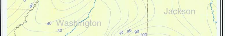


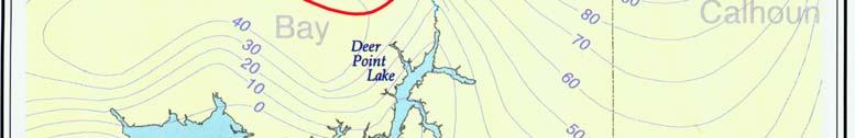
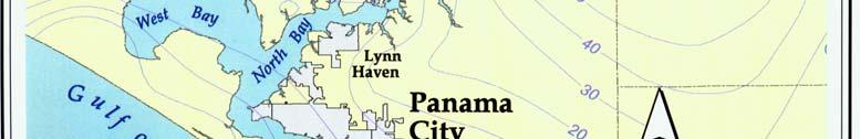


18 Floridan Aquifer Potentiometric Surface Data

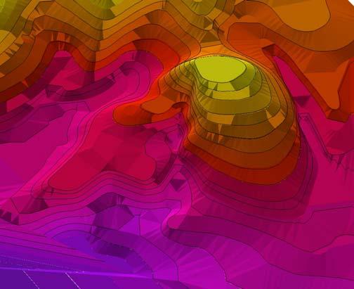
19 3D view of springs locations and FA discharge prediction


20 Econfina Springs Contribution Area Trace #2, 2.6 miles: first recovery 21 days after introduction, continued recovery for 33 days Trace #1, 1.8 miles: first recovery three days after introduction, continued recovery for 44 days


21 Land Use The NWFWMD has purchased approximately a quarter of the springs recharge basin The NWFWMD has purchased approximately a quarter of the springs recharge basin 3% 2% 1% 1% 0% 1% Coniferous Plantations Mixed Coniferous/Hardwood Forest Open Land (Urban) 29% Lakes, Streams, & Wetlands 63% Cropland and Pastureland Residential, low density Residential, medium density Everything Else

22 Econfina Creek Springs

23 Springs Discharge Econfina Creek Springs Discharge Gainer Springs discharge (cfs) LEGEND Econfina Below Springs Econfina Above Gainer Group Gainer Group Discharge Bluff Spring Fenceline Spring Barking Spring Bathtub Spring Livery Springs Pitts Spring Williford Springs Blue Springs Sylvan Springs Tupelo Spring Palm Spring Glowing Spring Net Devils Hole Net 100 Gainer Group Median Discharge = 168cfs 10 Inventory Discharge (cfs) /5/01 5/24/02 12/10/02 6/28/03 1/14/04 8/1/04 2/17/05 9/5/05 Date One first-magnitude (100 cfs and up) spring Gainer Springs Group Four second-magnitude (10 to 100 cfs) springs Glowing, Devils Hole, Williford and Sylvan Springs Six third-magnitude Springs and a plethora of fourth-magnitude and smaller springs

24 Water Quality Nitrate Data Springs Initiative Nitrate+Nitrite, Total (mg/l) Jackson Blue Spring Gainer Spring #1C Gainer Spring #2 Gainer Spring #3 Spring Creek Rise #2 Wakulla Spring Cypress Spring Morrison Spring /28/2001 2/13/2002 9/1/2002 3/20/ /6/2003 4/23/ /9/2004 Date


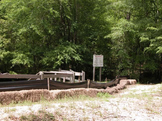
25 Litter and Erosion

26 Sylvan Spring #1

27 Devil s Hole

28 Gainer Spring #1B

29 River Frog Tadpole Rana heckscheri
Florida s Karst Geology
 Florida s Karst Geology Orange Creek Basin Interagency Working Group Public Workshop, November 5 th, 2015 Harley Means, P.G. Assistant State Geologist Florida Geological Survey Karst Karst a type of topography
TAMPA BAY TRIBUTARIES BASIN. Hydrogeological Setting
 TAMPA BAY TRIBUTARIES BASIN Hydrogeological Setting Aquifers within the Tampa Bay Tributaries Basins ground water flow system include the Floridan aquifer system, the intermediate aquifer system, and the
Mammoth Cave National Park, Kentucky
 Mammoth Cave National Park, Kentucky Objectives of Today s Lecture Refresher on Sedimentary Depositional Systems and Rock Classifications Transgressive and Regressive Marine Environments Carbonate Depositional
Soils, Hydrogeology, and Aquifer Properties. Philip B. Bedient 2006 Rice University
 Soils, Hydrogeology, and Aquifer Properties Philip B. Bedient 2006 Rice University Charbeneau, 2000. Basin Hydrologic Cycle Global Water Supply Distribution 3% of earth s water is fresh - 97% oceans 1%
The Favorability of Florida s Geology to Sinkhole Formation
 Florida Geological Survey The Favorability of Florida s Geology to Sinkhole Formation Clint Kromhout Alan Baker October 24, 2017 Subsidence Report Database Map of Subsidence Incident Reports taken from
Chapter 3 Erosion in the Las Vegas Wash
 Chapter 3 Erosion in the Las Vegas Wash Introduction As described in Chapter 1, the Las Vegas Wash (Wash) has experienced considerable change as a result of development of the Las Vegas Valley (Valley).
Simulating the groundwater discharge to wetlands. Mukwonago Basin Example and Potential Application in Dane County
 Simulating the groundwater discharge to wetlands Mukwonago Basin Example and Potential Application in Dane County Conceptual Model Topography is major control on flow to wetlands Land Surface Water Table
MARINE GEOLOGY & GEOGRAPHY
 MARINE GEOLOGY & GEOGRAPHY Bathymetry BATHYMETRY BATHYMETRY THE UNDERWATER EQUIVALENT TO TOPOGRAPHY THE STUDY OF WATER DEPTH A BATHYMETRIC MAP SHOWS FLOOR RELIEF OR TERRAIN AS CONTOUR LINES Bathymetry
LBJWC - Sinkhole Lesson
 LBJWC - Sinkhole Lesson Concept Caves and sinkholes are major openings in the ground that recharge water to the Edwards Aquifer. Objective - Students will: 1) identify a sinkhole, cave, fracture, fault,
MARINE GEOLOGY & GEOGRAPHY
 MARINE GEOLOGY MARINE GEOLOGY & GEOGRAPHY Marine Geology 4 LAYERS OF THE EARTH CRUST THICKNESS: VARIES BETWEEN OCEAN & CONTINENTS 5-40 KM STATE: SOLID ELEMENTS: SILICON, ALUMINUM, CALCIUM, SODIUM, POTASSIUM
WATER ON AND UNDER GROUND. Objectives. The Hydrologic Cycle
 WATER ON AND UNDER GROUND Objectives Define and describe the hydrologic cycle. Identify the basic characteristics of streams. Define drainage basin. Describe how floods occur and what factors may make
11/22/2010. Groundwater in Unconsolidated Deposits. Alluvial (fluvial) deposits. - consist of gravel, sand, silt and clay
 deposits. - consist of gravel, sand, silt and clay") Groundwater in Unconsolidated Deposits Alluvial (fluvial) deposits - consist of gravel, sand, silt and clay - laid down by physical processes in rivers and flood plains - major sources for water supplies
Groundwater in Unconsolidated Deposits Alluvial (fluvial) deposits - consist of gravel, sand, silt and clay - laid down by physical processes in rivers and flood plains - major sources for water supplies
Hydrogeology of Karst NE Wisconsin. Dr. Maureen A. Muldoon UW-Oshkosh Geology Department
 Hydrogeology of Karst NE Wisconsin Dr. Maureen A. Muldoon UW-Oshkosh Geology Department WI Bedrock Outline Karst Landscapes Existing WQ Data Flow in Karst Aquifers Overview of Silurian Aquifer Water Level
The Niagara Escarpment extends from western New York, through the GTA all the way up to Manitoulin Island and into Michigan and Wisconsin.
 is southern Ontario s most prominent topographic feature, extending more than 500 kilometres from western New York, through Niagara Falls and the western part of the Greater Toronto Area (GTA), and north
Prof. Stephen A. Nelson EENS 111. Groundwater
 Page 1 of 8 Prof. Stephen A. Nelson EENS 111 Tulane University Physical Geology This page last updated on 20-Oct-2003 is water that exists in the pore spaces and fractures in rock and sediment beneath
IDENTIFYING GROUNDWATER/STREAM INTERACTION IN THE LOWER FLINT RIVER BASIN USING MULTIPLE STREAM PARAMETERS AND REMOTE SENSING DATA SETS
 IDENTIFYING GROUNDWATER/STREAM INTERACTION IN THE LOWER FLINT RIVER BASIN USING MULTIPLE STREAM PARAMETERS AND REMOTE SENSING DATA SETS Kathleen Rugel 1,2, Stephen W. Golladay 2, C. Rhett Jackson 3 AUTHORS:
RIVERS, GROUNDWATER, AND GLACIERS
 RIVERS, GROUNDWATER, AND GLACIERS Delta A fan-shaped deposit that forms when a river flows into a quiet or large body of water, such as a lake, an ocean, or an inland sea. Alluvial Fan A sloping triangle
Geology and Soils. Technical Memorandum
 Geology and Soils Technical Memorandum TO: FDOT FROM: HDR, Inc. DATE: February 2013 PROJECT: St Johns River Crossing FPID No: 208225-3-21-01 Clay, Duval, and St. Johns Counties; Florida Geology and soils
Reading Material. See class website. Sediments, from Oceanography M.G. Gross, Prentice-Hall
 Reading Material See class website Sediments, from Oceanography M.G. Gross, Prentice-Hall Materials filling ocean basins Dissolved chemicals especially from rivers and mid-ocean ridges (volcanic eruptions)
 12 10 8 6 4 2 0 40-50 50-60 60-70 70-80 80-90 90-100 Fresh Water What we will cover The Hydrologic Cycle River systems Floods Groundwater Caves and Karst Topography Hot springs Distribution of water in
6.1 Water. The Water Cycle
 6.1 Water The Water Cycle Water constantly moves among the oceans, the atmosphere, the solid Earth, and the biosphere. This unending circulation of Earth s water supply is the water cycle. The Water Cycle
W he natural resources of Adams
 Above: Houghton Rock, Town of Adams. Following Page: "The Hole in the Rock" on Rattlesnake Mound--both remnants of rock formed by ancient seas hundreds of millions of year5 ago. (Courtesy, H.H. Bennett
Prentice Hall EARTH SCIENCE
 Prentice Hall EARTH SCIENCE Tarbuck Lutgens Running Water and Groundwater Running Water The Water Cycle Water constantly moves among the oceans, the atmosphere, the solid Earth, and the biosphere. This
Understanding Earth Fifth Edition
 Understanding Earth Fifth Edition Grotzinger Jordan Press Siever Chapter 5: SEDIMENTATION: Rocks Formed by Surface Processes Lecturer: H Mohammadzadeh Assistant professors, Department of Geology, FUM Copyright
Ms. A. Mormando's Class *
 8 th Grade Science Essential Standard: 8.E.1.1 Explain the structure of the hydrosphere including: Water distribution on Earth; Local river basin and water availability Stream - A stream is a body of water
Groundwater Sensitivity Regions of Kentucky
 Groundwater Sensitivity Regions of Kentucky by Kentucky Department for Environmental Protection Division of Water Groundwater Branch 1994 Interpreted by Joseph A. Ray James S. Webb Phillip W. O'dell Scale
This material is part of the collection of the Philadelphia Water Department and was downloaded from the website Please contact the
 This material is part of the collection of the Philadelphia Water Department and was downloaded from the website www.phillyh2o.org Please contact the PhillyH2O webmaster for more information about this
Mesozoic Earth History
 Mesozoic Earth History The Mesozoic Era 251-66 MYA Breakup of Pangea Changes in air and oceanic currents Evolution of new terrestrial and marine life Opening of the Atlantic Ocean Basin Rocky Mountains
FLORIDA GEOLOGICAL SURVEY Walter Schmidt, State Geologist. Frank R. Rupert. FLORIDA GEOLOGICAL SURVEY Tallahassee, Florida 1990
 STATE OF FLORIDA DEPARTMENT OF NATURAL RESOURCES Tom Gardner, Executive Director DIVISION OF RESOURCE MANAGEMENT Jeremy A. Craft, Director FLORIDA GEOLOGICAL SURVEY Walter Schmidt, State Geologist OPEN
Module 10: Resources and Virginia Geology Topic 4 Content: Virginia Geology Notes
 Virginia is composed of a very diverse landscape that extends from the beaches and barrier islands all of the way to the highly elevated Appalachian Plateau. Geologists have discovered ancient shallow
Wisconsin s Hydrogeology: an overview
 2012 Soil and Water Conservation Society Conference Stevens Point, WI Feb 9, 2012 Wisconsin s Hydrogeology: an overview Ken Bradbury Wisconsin Geological and Natural History Survey University of Wisconsin-Extension
Groundwater in Bayfield County
 Groundwater in Bayfield County Presented to Bayfield County Large Scale Livestoc Study Committee April 23, 2015 Madeline Gotowitz Hydrogeologist Groundwater in Bayfield County Groundwater basics Hydrogeology
Sediment and sedimentary rocks Sediment
 Sediment and sedimentary rocks Sediment From sediments to sedimentary rocks (transportation, deposition, preservation and lithification) Types of sedimentary rocks (clastic, chemical and organic) Sedimentary
Ocean Basins, Bathymetry and Sea Levels
 Ocean Basins, Bathymetry and Sea Levels Chapter 4 Please read chapter 5: sediments for next class and start chapter 6 on seawater for Thursday Basic concepts in Chapter 4 Bathymetry the measurement of
EVALUATION OF THE DOWNWARD MIGRATION OF SALTWATER TO THE UPPER FLORIDAN AQUIFER IN THE SAVANNAH, GEORGIA, AND HILTON HEAD ISLAND, SOUTH CAROLINA, AREA
 EVALUATION OF THE DOWNWARD MIGRATION OF SALTWATER TO THE UPPER FLORIDAN AQUIFER IN THE SAVANNAH, GEORGIA, AND HILTON HEAD ISLAND, SOUTH CAROLINA, AREA Camille Ransom, III 1, James E. Landmeyer 2, W. Robert
STUDY GUIDE FOR CONTENT MASTERY. Surface Water Movement
 Surface Water SECTION 9.1 Surface Water Movement In your textbook, read about surface water and the way in which it moves sediment. Complete each statement. 1. An excessive amount of water flowing downslope
Developed in Consultation with Florida Educators
 Developed in Consultation with Florida Educators Table of Contents Next Generation Sunshine State Standards Correlation Chart... 7 Benchmarks Chapter 1 The Practice of Science...................... 11
Earth s Layers. Earth s Surface
 CHAPTER 1 LESSON 3 Earth s Layers Earth s Surface Key Concepts What are Earth s major landforms and how do they compare? What are the major landform regions of the United States? What do you think? Read
Sediment and nutrient transport and storage along the urban stream corridor
 Sediment and nutrient transport and storage along the urban stream corridor Greg Noe, Cliff Hupp, Ed Schenk, Jackie Batson, Nancy Rybicki, Allen Gellis What is the role of floodplains everywhere? Noe 2013,
Virginia Walsh, PhD, P.G. Ed Rectenwald, P.G. April 5, 2016
 Miami-Dade Water & Sewer Department Cenozoic and Late Mesozoic Geology and Hydrogeology Of a 10,000 foot Exploratory Well Virginia Key, Florida Virginia Walsh, PhD, P.G. Ed Rectenwald, P.G. April 5, 2016
1.72, Groundwater Hydrology Prof. Charles Harvey Lecture Packet #5: Groundwater Flow Patterns. Local Flow System. Intermediate Flow System
 1.72, Groundwater Hydrology Prof. Charles Harvey Lecture Packet #5: Groundwater Flow Patterns c Local Flow System 10,000 feet Intermediate Flow System Regional Flow System 20,000 feet Hydrologic section
Chapter 8 Fetter, Applied Hydrology 4 th Edition, Geology of Groundwater Occurrence
 Chapter 8 Fetter, Applied Hydrology 4 th Edition, 2001 Geology of Groundwater Occurrence Figure 8.42. Alluvial Valleys ground-water region. Fetter, Applied Hydrology 4 th Edition, 2001 Fetter, Applied
10/27/2014. Surface Processes. Surface Processes. Surface Processes. Surface Processes. Surface Processes
 Hewitt/Lyons/Suchocki/Yeh Conceptual Integrated Science Chapter 25 Surface or surficial processes originate at Earth's surface and reshape its contours. Surface processes include: Weathering Erosion Deposition
The Geology of Sebago Lake State Park
 Maine Geologic Facts and Localities September, 2002 43 55 17.46 N, 70 34 13.07 W Text by Robert Johnston, Department of Agriculture, Conservation & Forestry 1 Map by Robert Johnston Introduction Sebago
Hydraulic Impacts of Limestone Quarries and Gravel Pits. Jeff Green Minnesota DNR-Division of Ecological & Water Resources
 Hydraulic Impacts of Limestone Quarries and Gravel Pits Jeff Green Minnesota DNR-Division of Ecological & Water Resources The Hydraulic Impacts of Limestone Quarries and Gravel Pits Study was funded by
Depositional Environment
 Depositional Environment Sedimentary depositional environment describes the combination of physical, chemical and biological processes associated with the deposition of a particular type of sediment. Types
Upper Truckee River Restoration Lake Tahoe, California Presented by Brendan Belby Sacramento, California
 Upper Truckee River Restoration Lake Tahoe, California Presented by Brendan Belby Sacramento, California Mike Rudd (Project Manager), Charley Miller & Chad Krofta Declines in Tahoe s Water Clarity The
mountain rivers fixed channel boundaries (bedrock banks and bed) high transport capacity low storage input output
 high transport capacity low storage input output") mountain rivers fixed channel boundaries (bedrock banks and bed) high transport capacity low storage input output strong interaction between streams & hillslopes Sediment Budgets for Mountain Rivers Little
mountain rivers fixed channel boundaries (bedrock banks and bed) high transport capacity low storage input output strong interaction between streams & hillslopes Sediment Budgets for Mountain Rivers Little
Implementing a Project with 319 Funds: The Spring Brook Meander Project. Leslie A. Berns
 Implementing a Project with 319 Funds: The Spring Brook Meander Project Leslie A. Berns "...to acquire... and hold lands... for the purpose of protecting and preserving the flora, fauna and scenic beauties...
EMERGENCY INVESTIGATION OF EXTREMELY LARGE SINKHOLES, MAOHE, GUANGXI, CHINA
 EMERGENCY INVESTIGATION OF EXTREMELY LARGE SINKHOLES, MAOHE, GUANGXI, CHINA Mingtang Lei, Xiaozhen Jiang, Zhende Guan Institute of Karst Geology, CAGS, Guilin, China, mingtanglei@hotmail.com Yongli Gao
What is a water table? What is an aquifer? What is the difference between a spring and a well?
 CHAPTER 11 3 Water Underground SECTION The Flow of Fresh Water BEFORE YOU READ After you read this section, you should be able to answer these questions: What is a water table? What is an aquifer? What
Riparian Assessment. Steps in the right direction... Drainage Basin/Watershed: Start by Thinking Big. Riparian Assessment vs.
 Riparian Assessment vs. Monitoring Riparian Assessment What is a healthy stream? Determine stream/riparian health Determine change or trend, especially in response to mgmt Classification = designation
Chapter 14: Groundwater. Fig 14.5b
 Chapter 14: Groundwater Fig 14.5b OBJECTIVES Recognize that groundwater is a vital source of accessible freshwater. Describe how groundwater forms below the water table. Explain the origin of aquifers,
Karst found mostly in limestone (rock with at least 50% carbonate minerals), depends on 1) permeability & porosity
, depends on 1) permeability & porosity") KARST LANDFORMS produced by weathering & erosion in regions of carbonate rocks and evaporites processes called karstification mainly below ground surface predominantly underground drainage poorly-developed
KARST LANDFORMS produced by weathering & erosion in regions of carbonate rocks and evaporites processes called karstification mainly below ground surface predominantly underground drainage poorly-developed
Evolution of the conceptual hydrogeologic and ground-water flow model for Las Vegas Valley, Clark County, Nevada
 Evolution of the conceptual hydrogeologic and ground-water flow model for Las Vegas Valley, Clark County, Nevada Geological Society of America Annual Meeting November 14, 2 David J. Donovan Southern Nevada
Earth / Environmental Science. Ch. 14 THE OCEAN FLOOR
 Earth / Environmental Science Ch. 14 THE OCEAN FLOOR The Blue Planet Nearly 70% of the Earth s surface is covered by the global ocean It was not until the 1800s that the ocean became an important focus
GEOL Introductory Geology: Exploring Planet Earth Fall 2010 Test #2 October 18, 2010
 GEOL 101 - Introductory Geology: Exploring Planet Earth Fall 2010 Test #2 October 18, 2010 Name KEY ID# KEY Multiple choice questions (2 points each). 1. What type of metamorphic rock is formed over large
Surface Processes Focus on Mass Wasting (Chapter 10)
") Surface Processes Focus on Mass Wasting (Chapter 10) 1. What is the distinction between weathering, mass wasting, and erosion? 2. What is the controlling force in mass wasting? What force provides resistance?
Surface Processes Focus on Mass Wasting (Chapter 10) 1. What is the distinction between weathering, mass wasting, and erosion? 2. What is the controlling force in mass wasting? What force provides resistance?
The Ocean Floor Chapter 14. Essentials of Geology, 8e. Stan Hatfield and Ken Pinzke Southwestern Illinois College
 The Ocean Floor Chapter 14 Essentials of Geology, 8e Stan Hatfield and Ken Pinzke Southwestern Illinois College The vast world ocean Earth is often referred to as the water planet 71% of Earth s surface
A view of the Gregory-Houe from the River-'Note the floodpiain surface andithe tree roots eiposed by erosion of the rivei bank.
 Leaflet No. i On the front cdver: A view of the Gregory-Houe from the River-'Note the floodpiain surface andithe tree roots eiposed by erosion of the rivei bank. Inside-thelbackcoveari Map of Torre4 a
Groundwater Hydrology
 EXERCISE 12 Groundwater Hydrology INTRODUCTION Groundwater is an important component of the hydrologic cycle. It feeds lakes, rivers, wetlands, and reservoirs; it supplies water for domestic, municipal,
Biostratigraphic and Lithostratigraphic Correlation of Sedimentary Strata in the Atlantic Coastal Plain
 Biostratigraphic and Lithostratigraphic Correlation of Sedimentary Strata in the Atlantic Coastal Plain Introduction to the Atlantic Coastal Plain (Please read this page prior to doing the lab) The Atlantic
Earth s Structure and Surface
 Earth s Structure and Surface Structure of the Earth The earth is thought have originated about 4.5 billion years ago from a cloud or clouds of dust. The dust was the remains of a huge cosmic explosion
Lecture 15: Subsidence
 Lecture 15: Subsidence Key Questions 1. How does removal of groundwater cause subsidence on a regional scale? 2. Under what conditions does a building sink into sediment? 3. Why do clays consolidate more
Rockall Plateau. OCN 201: Shelf Sediments
 Rockall Plateau OCN 201: Shelf Sediments Classification by Size Classification by Mode of Formation Detrital sediments Transported and deposited as particles Derived from weathering of pre-existing rocks
Enhanced Characterization of the Mississippi River Valley Alluvial Aquifer Using Surface Geophysical Methods
 Photo by Shane Stocks, U.S. Geological Survey Enhanced Characterization of the Mississippi River Valley Alluvial Aquifer Using Surface Geophysical Methods Presented by Ryan F. Adams US Geological Survey
Chapter 6 Mapping and Online Tools
 Chapter 6 Mapping and Online Tools The stream site you monitor is just part of a much larger system. When analyzing stream health, it is important to take a holistic view by considering the entire watershed.
The Building of the NYC Region
 The Building of the NYC Region Definitions Fall Line marks the area where an upland region (continental bedrock) and a coastal plain meet Piedmont the plateau region of the eastern United States which
P.R. SPRING AND HILL CREEK TAR SAND AREAS A RESOURCE ASSESSMENT (IN PROGRESS)
") P.R. SPRING AND HILL CREEK TAR SAND AREAS A RESOURCE ASSESSMENT (IN PROGRESS) presented by WALLY GWYNN - Utah Geological Survey at the Western U.S. Oil Sands Technology Transfer Meeting February 22, 2008
P.R. SPRING AND HILL CREEK TAR SAND AREAS A RESOURCE ASSESSMENT (IN PROGRESS) presented by WALLY GWYNN - Utah Geological Survey at the Western U.S. Oil Sands Technology Transfer Meeting February 22, 2008
Cretaceous, Dakota Formation, Terra Cotta Member South Side of I-70, Salina County, Kansas
 Cretaceous, Dakota Formation, Terra Cotta Member South Side of I-70, Salina County, Kansas Written By: Steven D.J. Baumann G-102010-1A Outcrop looking southeast Photo taken by: Steven Baumann on 10-20-2010
Geotechnical Aspects of the Ohio River Bridges Project
 Geotechnical Aspects of the Ohio River Bridges Project Mark A. Litkenhus, PE Sr. Geotechnical Engineer Stephen H. Bickel, PE Sr. Geotechnical Engineer STGEC Ohio River Bridges at Louisville Geotechnical
Fossils and Geology of Litzsinger Road Ecology Center
 Fossils and Geology of Litzsinger Road Ecology Center Table of Content Key Terms 1 Key Terms 2 What you need to know Geologic Map of Missouri Geologic Time Chart More of what you need to know Digital map
QUANTITY, MARCH 1962
 BASE-FLOW STUDIES, GUADALUPE RIVER COMAL COUNTY, TEXAS QUANTITY, MARCH 1962 TEXAS WATER COMMISSION BULLETIN 6503 MARCH 1965 TEXAS WATER COMMISSION Joe William D E 0. F. Dent Carter, Chairman Berger, Commissioner
Map shows 3 main features of ocean floor
 Map shows 3 main features of ocean floor 2017 Pearson Education, Inc. Chapter 3 Marine Provinces 2017 Pearson Education, Inc. 1 Chapter 3 Overview The study of bathymetry determines ocean depths and ocean
Appendix F4.11 Geologic Unit Summaries, Hazard Areas, and Boring Locations
 Appendix F4.11 Geologic Unit Summaries, Hazard Areas, and Boring Locations Appendix F4.11 Geologic Unit Summaries and Hazard Areas TABLE F4.11-1 Summary of Geologic Units and their Engineering Properties
Today I will describe the groundwater/surface water interaction in the CRB in Mosier basin.
 Today I will describe the groundwater/surface water interaction in the CRB in Mosier basin. 1 Ken Lite, studying groundwater resource in Mosier basin since 1980 s (photo by A. Bouchier) 2012 with Jonathan
Potential short answer questions: What is Pangea? Describe at least 4 pieces of evidence that led Wegener to suggest the theory of Continental Drift.
 6th Grade Earth Science Fall Semester Mid-Term Study Guide The mid-term may include: 4 short answer questions,1-2 sketches to draw and/or label, 4 partially filled charts which you should complete, 30
Natural hazards in Glenorchy Summary Report May 2010
 Natural hazards in Glenorchy Summary Report May 2010 Contents Glenorchy s hazardscape Environment setting Flood hazard Earthquakes and seismic hazards Hazards Mass movement Summary Glossary Introduction
Geoscience 001 Fall Rock Identification and Contextual Interpretation
 Geoscience 00 Fall 2005 Rock Identification and Contextual Interpretation The purpose of this week s lab is to gain some more experience and practice in identifying rocks and then interpreting the geologic
Shallow Karst Aquifer System of the Lake Belt Study Area, Miami-Dade County, Florida, USA EXTENDED ABSTRACT
 Second International Conference on Saltwater Intrusion and Coastal Aquifers Monitoring, Modeling, and Management. Merida, Mexico, March 30 April 2, 2003 Shallow Karst Aquifer System of the Lake Belt Study
Rivers T. Perron
 1 Rivers T. Perron 12.001 After our discussions of large-scale topography, how we represent topography in maps, and how topography interacts with geologic structures, you should be frothing at the mouth
INVESTIGATIONS OF LARGE SCALE SINKHOLE COLLAPSES, LAIBIN, GUANGXI, CHINA
 INVESTIGATIONS OF LARGE SCALE SINKHOLE COLLAPSES, LAIBIN, GUANGXI, CHINA Yongli Gao Department of Geological Sciences, Center for Water Research, University of Texas at San Antonio, TX 78249, USA, yongli.gao@utsa.edu
Chapter 13. Groundwater
 Chapter 13 Groundwater Introduction Groundwater is all subsurface water that completely fills the pores and other open spaces in rocks, sediments, and soil. Groundwater is responsible for forming beautiful
State of Florida Department of Natural Resources Virginia B. Wetherell, Executive Director. Division of Resource Management Jeremy A.
 State of Florida Department of Natural Resources Virginia B. Wetherell, Executive Director Division of Resource Management Jeremy A. Craft, Director Florida Geological Survey Walter Schmidt, State Geologist
Chapter 14. Groundwater
 Chapter 14 Groundwater Importance of groundwater! Groundwater is water found in the pores of soil and sediment, plus narrow fractures in bedrock! Groundwater is the largest reservoir of fresh water that
STUDY GUIDE FOR CONTENT MASTERY. Movement and Storage of Groundwater
 Groundwater SECTION 10.1 Movement and Storage of Groundwater In your textbook, read about the hydrosphere, precipitation and groundwater, and groundwater storage. Use the following terms to complete the
Kaibab Limestone Toroweap Formation Coconino Sandstone. Hermit Shale. Redwall Limestone. Muav Limestone. Bright Angel Shale.
 ITHOSTRATIGRAPHY Kaibab imestone Toroweap Formation Coconino Sandstone Hermit Shale Redwall imestone Muav imestone Bright Angel Shale Tapeats imestone Brahma Schist These are the Paleogene rocks that occur
Land subsidence due to groundwater withdrawal in Hanoi, Vietnam
 Land Subsidence (Proceedings of the Fifth International Symposium on Land Subsidence, The Hague, October 1995). 1AHS Publ. no. 234, 1995. 55 Land subsidence due to groundwater withdrawal in Hanoi, Vietnam
Moosehead Lake and the Tale of Two Rivers
 Maine Geologic Facts and Localities June, 2005 45 o 53 5.09 N, 69 o 42 14.54 W Text by Kelley, A.R.; Kelley, J.T.; Belknap, D.F.; and Gontz, A.M. Department of Earth Sciences, University of Maine, Orono,
What we will cover. The Hydrologic Cycle. River systems. Floods. Groundwater. Caves and Karst Topography. Hot springs
 Fresh Water What we will cover The Hydrologic Cycle River systems Floods Groundwater Caves and Karst Topography Hot springs On a piece of paper, put these reservoirs of water in to order from largest to
b. Why is the area affected by each earthquake circular or nearly circular? Where is the epicenter of each quake located?
 Name: Skill Sheet 29-A Interpreting Geologic Hazard Maps Plate tectonics and the weather are often the cause of geologic hazards such as earthquakes, volcanic eruptions, and flooding. Geologic hazard events
Rivers and Streams. Streams. Hydrologic Cycle. Drainage Basins and Divides. Colorado River Drainage Basin. Colorado Drainage Basins.
 Chapter 14 Hydrologic Cycle Rivers and Streams Streams A stream is a body of water that is confined in a channel and moves downhill under the influence of gravity. This definition includes all sizes of
Ecoregions Glossary. 7.8B: Changes To Texas Land Earth and Space
 Ecoregions Glossary Ecoregions The term ecoregions was developed by combining the terms ecology and region. Ecology is the study of the interrelationship of organisms and their environments. The term,
WHAT IS THE EARTH MADE OF? LITHOSPHERE AND HYDROSPHERE
 UNIT 8 WHAT IS THE EARTH MADE OF? LITHOSPHERE AND HYDROSPHERE TABLE OF CONTENTS 1 THE STRUCTURE OF THE EARTH... 2 2 THE FORMATION OF THE RELIEF: INTERNAL AND EXTERNAL FORCES.... 2 2.1 Internal forces:
Lecture Outlines PowerPoint. Chapter 5 Earth Science 11e Tarbuck/Lutgens
 Lecture Outlines PowerPoint Chapter 5 Earth Science 11e Tarbuck/Lutgens 2006 Pearson Prentice Hall This work is protected by United States copyright laws and is provided solely for the use of instructors
Hydrogeological Assessment for Part of Lots 2 and 3, Concession 5, Township of Thurlow, County of Hastings 1.0 INTRODUCTION. 1.
 February 10,2017 25506400 Ontario Ltd. Foxboro, ON Attention: Brad Newbatt Re: Hydrogeological Assessment for Part of Lots 2 and 3, Concession 5, Township of Thurlow, County of Hastings 1.0 INTRODUCTION
Sediment and Sedimentary rock
 Sediment and Sedimentary rock Sediment: An accumulation of loose mineral grains, such as boulders, pebbles, sand, silt or mud, which are not cemented together. Mechanical and chemical weathering produces
Bathymetry Measures the vertical distance from the ocean surface to mountains, valleys, plains, and other sea floor features
 1 2 3 4 5 6 7 8 9 10 11 CHAPTER 3 Marine Provinces Chapter Overview The study of bathymetry determines ocean depths and ocean floor topography. Echo sounding and satellites are efficient bathymetric tools.
Fluvial Systems Lab Environmental Geology Lab Dr. Johnson
 Fluvial Systems Lab Environmental Geology Lab Dr. Johnson *Introductory sections of this lab were adapted from Pidwirny, M. (2006). "Streamflow and Fluvial Processes". Fundamentals of Physical Geography,
Students will be able to identify vocabulary related to Florida water and wetlands
 Pre Visit 1 What s in your Water 6-8 Vocabulary Purpose/Objective Students will be able to identify vocabulary related to Florida water and wetlands Materials Word search copies Pencils Dictionaries Procedure