DANCORE-Day. Master s Thesis
|
|
|
- Cynthia Brittney Allen
- 6 years ago
- Views:
Transcription


1 DANCORE-Day Master s Thesis Interpretation of Shallow Seismic and Sediment Cores from the Area stretching from the Southern Part of Kattegat to the Great Belt in the Period Late-Weichselian to Early Holocene. Carina Bendixen Dias 1
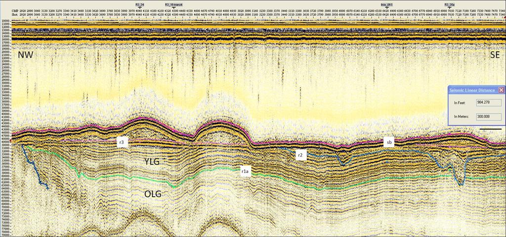
2 Content - Aim of project - Regional geology - Results - Processing of seismic data - Vibrocores - Late Glacial sediments - Channel infill - Barrier islands - Discussion - Late Glacial sediments - Channel infill and faulting - Bathymetric map - Conclusion Dias 2
3 AIM OF THE PROJECT Aim of the project Outline the development of the study area from Late-Weichselian to Early Holocene - Interpreting shallow seismic 5 Boomer profiles 71 Sparker profiles - 10 Sediment cores Dias 3
 Fjord-like estuary Lowstand Holocene Rising sea level (transgression) Coastal barrier islands are flodded Dias 4")
4 REGIONAL GEOLOGY Regional Geology Jensen et al BP to BP Deglaciation of the southwestern Kattegat High sea level 60 m Younger Dryas AD to AD Lowest sea level m (b.s.l) Fjord-like estuary Lowstand Holocene Rising sea level (transgression) Coastal barrier islands are flodded Dias 4
5 RESULTS PROCESSING OF DATA Results Processing of data using ProMAX Boomer profiles - Navigation errors. Removal of traces - Frequency filtering - Bandpass filter Sparker profiles - Migration using the velocity 1480 m/s (Kirchhoff time migration with RMS Velocity) - Extended migration (three profiles) (Kirchhoff time migration with varying velocities) - Water: 1480 m/s - Sediment: 1600 m/s Dias 5

6 RESULTS PROCESSING OF DATA Boomer profile Dias 6

7 RESULTS PROCESSING OF DATA Sparker profile R3_019a Sted og dato Dias 7

8 RESULTS - VIBROCORES Sediment core - Vibrocores 4.14m 8.65m 3.82m 5.18m Dias 8
9 Results Results Late Glacial Dias 9 YLG Youngest Late Glacial OLD Oldest Late Glacial
10 Late Glacial Distribution of the Late Glacial sediments OLG YLG Sted og dato

11 Results Results Sted og dato Dias 11
12 Results Results infill Dias 12

13 Results/Discussion Results/Discussion Barrier Islands Dias 13

14 Discussion Discussion Late Glacial sediments - Sediments deposited during a high sea level (highstand) - The faulting that limits the distribution of the sediments occured before 15 cal. ka BP (Jensen et al., 2002A) Profil R3_006 Sted og dato Dias 14
15 CHANNEL INFILL Discussion Channel infill and faulting - Two types of sediment infill Different infill directions Change in environment Boundary between the two units represent a hiatus - Strike-slip faulting Possible event which caused gas migration Sted og dato Dias 15
16 Discussion Regression, Lowstand and Transgression Discussion Unit 2 r2 - Two erosional surfaces identified Lower boundary of unit 2 and unit 3 Possible tectonic offset causing a local transgression (deposition of unit 2) Limited distribution of unit 2 due to erosion - Reflector r2 is at a lowstand level Limited distribution of the reflector - Can be due to erosion during the transgression Unit 3 r3 - Both units have a connection with the interpreted palaeo-great Belt channel Dias 16

17 DISCUSSION Discussion - Palaeo coastline - Palaeo-Great Belts canals - Sediment progradation - Back-stepping of barrier islands with rise in sea level Dias 17
18 CONCLUSION Conclusion - The processing of the seismic data have resulted in better data quality hence better interpretation - Interpretation of the bathymetric map has resulted in the identification of a former coastline. This has resulted in the construction of a palaeogeographical map - The Late Glacial sediments were deposited during high sea level (highstand) - The fualts that bounds the Late Glacial sediments occured before 15 cal. ka BP Dias 18
19 CONCLUSION Conclusion - During the regression a local transgression occurred where unit 2 were deposited - The Lowstand occurred before 9 cal. ka. BP - Two types of canal infill Change in infill direction Change in environment - Barrier islands are back-stepper with rising sea level and eventually drowned Dias 19
20 DANCORE-DAY Article Bendixen, C., Jensen, J.B., Bennike, O., & Boldreel, L.O. 2013: Late Glacial to Early Holocene development of southern Kattegat, Geological Survey of Denmark and Greenland Bulletin, accepted for publication Thanks My supervisors Lars Ole Boldreel (IGN) and Jørn Bo Jensen (GEUS) GEUS and Danish Nature Agency for providing the data Dias 20
21 Thank you for listening Any questions?
Late glacial to early Holocene development of southern Kattegat Bendixen, Carina; Jensen, Jørn Bo; Bennike, Ole; Boldreel, Lars Ole
 university of copenhagen Københavns Universitet Late glacial to early Holocene development of southern Kattegat Bendixen, Carina; Jensen, Jørn Bo; Bennike, Ole; Boldreel, Lars Ole Published in: Geological
Aspects of the Tertiary Development of the Wyville-Thomson Ridge Complex, SW Faroe Islands based on 2D digital seismic data
 Aspects of the Tertiary Development of the Wyville-Thomson Ridge Complex, SW Faroe Islands based on 2D digital seismic data Highlights of my Master Project at Institute of Geography and Geology, KU By
ON THE EVOLUTION OF A HOLOCENE BARRIER COAST
 ON THE EVOLUTION OF A HOLOCENE BARRIER COAST Response to sea-level change and sediment supply DANCORE Seminar 2014 COADAPT - Danish Coasts and Climate Adaptation Flooding Risk and Coastal Protection Mikkel
Vindmøller nord for Als i Lillebælt
 D A N M A R K S O G G R Ø N L A N D S G E O L O G I S K E U N D E R S Ø G E L S E R A P P O R T 2 0 1 6 / 29 Vindmøller nord for Als i Lillebælt Bathymetrisk og geologisk kortlægning af område til opstilling
Erosion and Accretion Patterns along the Danish Shores
 Department of Geosciences and Natural Resource Management rosion and Accretion Patterns along the Danish Shores Aart Kroon Danish Coasts and Climate Adaptation (COADAPT) Climate Change and Coastal Adaptation
Seismic stratigraphy, some examples from Indian Ocean, interpretation of reflection data in interactive mode
 Seismic stratigraphy, some examples from Indian Ocean, interpretation of reflection data in interactive mode K. S. Krishna National Institute of Oceanography, Dona Paula, Goa-403 004. krishna@nio.org Seismic
Comment on: Cenozoic evolution of the eastern Danish North Sea by M. Huuse, H. Lykke-Andersen and O. Michelsen, [Marine Geology 177, 243^269]
![Comment on: Cenozoic evolution of the eastern Danish North Sea by M. Huuse, H. Lykke-Andersen and O. Michelsen, [Marine Geology 177, 243^269]](/thumbs/93/112023617.jpg "Comment on: Cenozoic evolution of the eastern Danish North Sea by M. Huuse, H. Lykke-Andersen and O. Michelsen, [Marine Geology 177, 243^269]") Marine Geology 186 (2002) 571^575 Discussion Comment on: Cenozoic evolution of the eastern Danish North Sea by M. Huuse, H. Lykke-Andersen and O. Michelsen, [Marine Geology 177, 243^269] P. Japsen, T.
Marine Geology 186 (2002) 571^575 Discussion Comment on: Cenozoic evolution of the eastern Danish North Sea by M. Huuse, H. Lykke-Andersen and O. Michelsen, [Marine Geology 177, 243^269] P. Japsen, T.
Introduction to sequence stratigraphy and its application to reservoir geology
 Introduction to sequence stratigraphy and its application to reservoir geology Massimo Zecchin Istituto Nazionale di Oceanografia e di Geofisica Sperimentale - OGS Historical development Definitions Systems
II Why study coastal landforms?
 COASTAL LANDFORMS (32) I Main topics A Why study coastal landforms? B Sediment budget and system response C Coastal landforms 3/26/15 GG454 1 II Why study coastal landforms? A Dynamic systems B Reflect
Seismic interpretation. Principles of seismic stratigraphic interpretation
 Seismic interpretation Principles of seismic stratigraphic interpretation Seismic interpretation Seismic stratigraphy is a technical for interpreting stratigraphic information from seismic data. The resolution
Relative sea level in inner Nordfjord at 8150 cal. a BP
 Relative sea level in inner Nordfjord at 8150 cal. a BP Supporting information to Vasskog et al. Introduction The most precise way of determining past relative sea level in Scandinavia is considered to
Case Study of the Structural and Depositional-Evolution Interpretation from Seismic Data*
 Case Study of the Structural and Depositional-Evolution Interpretation from Seismic Data* Yun Ling 1, Xiangyu Guo 1, Jixiang Lin 1, and Desheng Sun 1 Search and Discovery Article #20143 (2012) Posted April
(1) Identify 5 major principles of relative dating? For each principle, describe how you tell what is younger and what is older.
 Identify 5 major principles of relative dating? For each principle, describe how you tell what is younger and what is older.") Things to Know - Third GLG101Exam Page 1 Important Note: This is not everything you need to know or study. However, it provides you with a relatively comprehensive list of questions to help you study.
Things to Know - Third GLG101Exam Page 1 Important Note: This is not everything you need to know or study. However, it provides you with a relatively comprehensive list of questions to help you study.
Depositional Sequences Sequences
 Depositional Sequences Transgressive and Regressive packages can be bound by unconformities Because sediment can only be preserved during net aggradation and progradation All other times there is either
Course Outline. TERM EFFECTIVE: Fall 2016 CURRICULUM APPROVAL DATE: 04/25/2016
 5055 Santa Teresa Blvd Gilroy, CA 95023 Course Outline COURSE: GEOL 1 DIVISION: 10 ALSO LISTED AS: TERM EFFECTIVE: Fall 2016 CURRICULUM APPROVAL DATE: 04/25/2016 SHORT TITLE: INTRO GEOLOGY L/L LONG TITLE:
Initial observations of the shallow geology in Tannis Bugt, Skagerrak, Denmark
 Initial observations of the shallow geology in Tannis Bugt, Skagerrak, Denmark Matthew J. Owen, Nicky H. Witt, Zyad Al-Hamdani, Niels Nørgaard-Pedersen, Katrine J. Andresen and Jørgen O. Leth During August
Figure 1: Dataset of 2008 Eglacom Cruise with R/V Explora ~1070 km of multichannel seismic reflection data reprocessed and interpreted for this
 Figure 1: Dataset of 2008 Eglacom Cruise with R/V Explora ~1070 km of multichannel seismic reflection data reprocessed and interpreted for this study. ODP Leg 986 used for calibration. MAGE data from Safronova
Ocean Basins, Bathymetry and Sea Levels
 Ocean Basins, Bathymetry and Sea Levels Chapter 4 Please read chapter 5: sediments for next class and start chapter 6 on seawater for Thursday Basic concepts in Chapter 4 Bathymetry the measurement of
Resilient deltas. Dr. Irina Overeem 1,2)
") Resilient deltas a case-study report on the Volga and Ganges delta systems Dr. Irina Overeem 1,2) 1) CSDMS, INSTAAR, University of Colorado, CO, Boulder, USA 2) Delft University of Technology, The Netherlands
Resilient deltas a case-study report on the Volga and Ganges delta systems Dr. Irina Overeem 1,2) 1) CSDMS, INSTAAR, University of Colorado, CO, Boulder, USA 2) Delft University of Technology, The Netherlands
Supplemental Slides. Shore: Junction of Land & Water. Junction of Land & Water. Sea Level Variations. Shore vs. Coast. Sea Level Variations
 Shore: Junction of Land & Water Supplemental Slides Sediments come off land Most get dumped at the beach Sediment interacts with ocean waves and currents Junction of Land & Water Features: Breaking waves,
Shore: Junction of Land & Water. Sediments come off land Most get dumped at the beach Sediment interacts with ocean waves and currents
 Shore: Junction of Land & Water Supplemental Slides Sediments come off land Most get dumped at the beach Sediment interacts with ocean waves and currents Junction of Land & Water Features: Breaking waves,
Lab 12 Coastal Geology
 Lab 12 Coastal Geology I. Fluvial Systems Hydrologic Cycle Runoff that flows into rivers = precipitation (rain and snowmelt) [infiltration (loss to groundwater) + evaporation (loss to atmosphere) + transpiration
Coastal Evolution in Sedimentary Areas in Greenland
 Coastal Evolution in Sedimentary Areas in Greenland Mette Bendixen P h D s t u d e n t DANCORE Young Professionals Day Dias 1 Outline Motivation State of the art on Arctic coasts Purpose of my Phd Presentation
Geoscience 001 Fall Rock Identification and Contextual Interpretation
 Geoscience 00 Fall 2005 Rock Identification and Contextual Interpretation The purpose of this week s lab is to gain some more experience and practice in identifying rocks and then interpreting the geologic
Meandering Miocene Deep Sea Channel Systems Offshore Congo, West Africa
 Meandering Miocene Deep Sea Channel Systems Offshore Congo, West Africa S. Baer* (PGS), J. E. Comstock (PGS), K. Vrålstad (PGS), R. Borsato (PGS), M. Martin (PGS), J.P. Saba (SNPC), B. Débi-Obambé (SNPC)
Relationship between gas-bearing (?) sediments and biogenic mounds in the Kalloni Gulf, Lesvos Island, Greece
 sediments and biogenic mounds in the Kalloni Gulf, Lesvos Island, Greece") 6 th Workshop Seabed Acoustics, Rostock, November 14/15, 2013 P13-1 Relationship between gas-bearing (?) sediments and biogenic mounds in the Kalloni Gulf, Lesvos Island, Greece Alexandros Chronis, Dr.
6 th Workshop Seabed Acoustics, Rostock, November 14/15, 2013 P13-1 Relationship between gas-bearing (?) sediments and biogenic mounds in the Kalloni Gulf, Lesvos Island, Greece Alexandros Chronis, Dr.
Depositional Environments and Hydrocarbon Potential of Northern Ionian Sea
 Depositional Environments and Hydrocarbon Potential of Northern Ionian Sea Vasiliki Kosmidou George Makrodimitras Nick Papatheodorou Contents Area of Interest Studied Dataset Workflow SWIT and Paleolatitude
Sedimentary Processes and Stratigraphic Responses in a Tectonically Driven Basin: Northern California Continental Shelf and Upper Slope
 Sedimentary Processes and Stratigraphic Responses in a Tectonically Driven Basin: Northern California Continental Shelf and Upper Slope LONG-TERM GOALS Craig S. Fulthorpe and James A. Austin, Jr. This
Mo Myce 06 Comparative Seismic Source Study for Buried Palaeolandscape Investigations in the Southern North Sea
 Mo Myce 06 Comparative Seismic Source Study for Buried Palaeolandscape Investigations in the Southern North Sea O.J. Zurita Hurtado* (Renard Centre of Marine Geology - Ghent University), T. Missiaen (Renard
Final Report on Development of Deep Aquifer Database and Preliminary Deep Aquifer Map
 4 CHAPTER Final Report on Development of Deep Aquifer Database and Preliminary Deep Aquifer Map 31 Chronostragraphic Mapping 4.1 Introduction The analysis of geological logs was conducted during the project
COASTAL QUATERNARY GEOLOGY MAPPING FOR NSW: EXAMPLES AND APPLICATIONS
 COASTAL QUATERNARY GEOLOGY MAPPING FOR NSW: EXAMPLES AND APPLICATIONS A Troedson Geological Survey of New South Wales Abstract Detailed geological mapping of the coastal plains of regional NSW was undertaken
Abstract. Introduction. Regional Setting. GCSSEPM to be published December 2003
 Shelf Margin Deltas and Associated Deepwater Deposits: Implications on Reservoir Distribution and Hydrocarbon Entrapment, Block VI-1, Ulleung Basin, East Sea, South Korea Sneider, John S. Sneider Exploration,
High-resolution Geophysical Mapping of Submarine Glacial Landforms
 High-resolution Geophysical Mapping of Submarine Glacial Landforms M. Jakobsson 1, J.A. Dowdeswell 2, M. Canals 3, B.J. Todd 4, E.K. Dowdeswell 2, K.A. Hogan 5 L.A. Mayer 6 1 Stockholm University, Sweden
Sequence Stratigraphy: An Applied Workshop
 Sequence Stratigraphy: An Applied Workshop Instructor: Prof. Octavian Catuneanu Level: Intermediate Duration: 5 days Course Description and Objectives This workshop presents the concepts and practical
GY 402: Sedimentary Petrology
 UNIVERSITY OF SOUTH ALABAMA GY 402: Sedimentary Petrology Lecture 28: Student Choice Lecture 1: Sequence Stratigraphy Instructor: Dr. Douglas W. Haywick Today Sequence Stratigraphy The basic concept (systems
Before Plate Tectonics: Theory of Continental Drift
 Before Plate Tectonics: Theory of Continental Drift Predecessor to modern plate tectonics Shape and fit of the continents was the initial evidence Snider-Pelligrini (1858) Taylor (1908) Wegner (1915) Fig.
Geologic Mapping Regional Tournament Trial Event
 Geologic Mapping Regional Tournament Trial Event A TEAM OF UP TO: 2 Team Name AVAILABLE TIME: 50 min Required Materials: Each team MUST have a protractor, ruler, non-programmable calculator, colored pencils,
Offshore Evidence for Uplift Rate Boundaries. Hans AbramsonWard Diablo Canyon SSHAC SSC Workshop 2 November 7, 2012
 Offshore Evidence for Uplift Rate Boundaries Hans AbramsonWard Diablo Canyon SSHAC SSC Workshop 2 November 7, 2012 Questions asked by the TI team Discuss your ability to distinguish and correlate offshore
MISSISSIPPI RIVER DELTA OVERVIEW
 MISSISSIPPI RIVER DELTA OVERVIEW Science and Engineering Special Team Conference Louisiana State University October 9, 2012 Introduction Basics of the Mississippi Delta Natural and Human-Induced Land Loss
Abstract. *Modified from extended abstract prepared for presentation at AAPG Annual Convention, Calgary, Alberta, June 19-22, 2005
 The Jurassic-Cretaceous North Sea Rift Dome and Associated Basin Evolution* By Ole Graversen 1 Search and Discovery Article #30040 (2006) Posted February 19, 2006 *Modified from extended abstract prepared
Seismic Geomorphology in the Late Cenozoic Depositional Evolution of the Gulf of Thailand
 Research article Seismic Geomorphology in the Late Cenozoic Depositional Evolution of the Gulf of Thailand Worawat Maharernthong, Piyaphong Chenrai* and Montri Choowong Department of Geology, Faculty of
Journal of Earth Sciences and Geotechnical Engineering, vol. 4, no. 1, 2014, ISSN: (print), (online) Scienpress Ltd, 2014
, (online) Scienpress Ltd, 2014") Journal of Earth Sciences and Geotechnical Engineering, vol. 4, no. 1, 2014, 17-24 ISSN: 1792-9040 (print), 1792-9660 (online) Scienpress Ltd, 2014 Reconstruction of Relative Tectonic Movements Using Transgressive
Journal of Earth Sciences and Geotechnical Engineering, vol. 4, no. 1, 2014, 17-24 ISSN: 1792-9040 (print), 1792-9660 (online) Scienpress Ltd, 2014 Reconstruction of Relative Tectonic Movements Using Transgressive
Hosgri-San Simeon Fault Zone Geologic Slip Rate
 Hosgri-San Simeon Fault Zone Geologic Slip Rate Insert picture(s) here Kathryn Hanson AMEC E&I Diablo Canyon SSHAC Project SSC Workshop 2 November 7, 2012 What insights have your geologic investigations
GLY 155 Introduction to Physical Geology, W. Altermann. Press & Siever, compressive forces. Compressive forces cause folding and faulting.
 Press & Siever, 1995 compressive forces Compressive forces cause folding and faulting. faults 1 Uplift is followed by erosion, which creates new horizontal surface. lava flows Volcanic eruptions cover
Rockall Plateau. OCN 201: Shelf Sediments
 Rockall Plateau OCN 201: Shelf Sediments Classification by Size Classification by Mode of Formation Detrital sediments Transported and deposited as particles Derived from weathering of pre-existing rocks
Sequence Stratigraphy as a tool for water resources management in alluvial coastal aquifers: application to the Llobregat delta (Barcelona, Spain)
") Sequence Stratigraphy as a tool for water resources management in alluvial coastal aquifers: application to the Llobregat delta (Barcelona, Spain) Desiré Gàmez Torrent December 2007 CHAPTER 1: Introduction
Sequence Stratigraphy as a tool for water resources management in alluvial coastal aquifers: application to the Llobregat delta (Barcelona, Spain) Desiré Gàmez Torrent December 2007 CHAPTER 1: Introduction
Lecture 9 faults, folds and mountain building
 Lecture 9 faults, folds and mountain building Rock deformation Deformation = all changes in size, shape, orientation, or position of a rock mass Structural geology is the study of rock deformation Deformation
Answers: Internal Processes and Structures (Isostasy)
") Answers: Internal Processes and Structures (Isostasy) 1. Analyse the adjustment of the crust to changes in loads associated with volcanism, mountain building, erosion, and glaciation by using the concept
Answers: Internal Processes and Structures (Isostasy) 1. Analyse the adjustment of the crust to changes in loads associated with volcanism, mountain building, erosion, and glaciation by using the concept
GEOLOGICAL SURVEY OF DENMARK AND GREENLAND: EARLY SKETCHES FOR A DETAILED NATIONWIDE 3D GEOLOGICAL MODEL BASED ON GEOPHYSICAL DATA AND BOREHOLES
 GEOLOGICAL SURVEY OF DENMARK AND GREENLAND: EARLY SKETCHES FOR A DETAILED NATIONWIDE 3D GEOLOGICAL MODEL BASED ON GEOPHYSICAL DATA AND BOREHOLES Flemming Jørgensen, Richard Thomsen, Peter.B.E. Sandersen
Bulletin of Earth Sciences of Thailand
 Quantitative Seismic Geomorphology of Early Miocene to Pleistocene Fluvial System of Northern Songkhla Basin, Gulf of Thailand Oanh Thi Tran Petroleum Geoscience Program, Department of Geology, Faculty
VHR seismic imaging of displacement along an active off-shore fault system of the Adriatic foreland
 VHR seismic imaging of displacement along an active off-shore fault system of the Adriatic foreland Daniela Di Bucci 1, Domenico Ridente 2, 3, Umberto Fracassi 4, Fabio Trincardi 2, Gianluca Valensise
PALEOGEOGRAPHY of NYS. Definitions GEOLOGIC PROCESSES. Faulting. Folding 9/6/2012. TOPOGRAPHIC RELIEF MAP of NYS GRADATIONAL TECTONIC
 TOPOGRAPHIC RELIEF MAP of NYS PALEOGEOGRAPHY of NYS Prof. Anthony Grande AFG 2012 Definitions GEOLOGIC PROCESSES Geography: study of people living on the surface of the earth. Geology: the scientific study
Facies Reconstruction of a Late Pleistocene Cypress Forest Discovered on the Northern Gulf of Mexico Continental Shelf
 Facies Reconstruction of a Late Pleistocene Cypress Forest Discovered on the Northern Gulf of Mexico Continental Shelf Suyapa Gonzalez 1, Samuel J. Bentley, Sr. 1, Kristine L. DeLong 3, Kehui Xu 2, Jeffrey
DATA REPOSITORY MATERIAL: PALEOCHANNEL GROUP MAPPING DESCRIPTIONS
 Data Repository item 2695 DATA REPOSITORY MATERIAL: PALEOCHANNEL GROUP MAPPING DESCRIPTIONS Groups 1 (North Myrtle Beach) and 2 (Atlantic Beach) Channel Groups 1 (North Myrtle Beach) and 2 (Atlantic Beach)
caribbean basins, tectonics and hydrocarbons university of texas institute for geophysics
 Copyright by Trevor John Aitken 2005 CENOZOIC STRATIGRAPHIC AND TECTONIC HISTORY OF THE GRENADA AND TOBAGO BASINS AS DETERMINED FROM MARINE SEISMIC DATA, WELLS, AND ONLAND GEOLOGY by Trevor John Aitken,
Tony Pratt, DNREC to The Center for the Inland Bays Scientific and Technical Advisory Committee. August 21, 2009
 Sea Level Rise in Delaware Presented by Tony Pratt, DNREC to The Center for the Inland Bays Scientific and Technical Advisory Committee August 21, 2009 Sea level has been fluctuating ever since there have
Sequence Stratigraphy. Historical Perspective
 Sequence Stratigraphy Historical Perspective Sequence Stratigraphy Sequence Stratigraphy is the subdivision of sedimentary basin fills into genetic packages bounded by unconformities and their correlative
Stratigraphy. Stratigraphy deals with the study of any layered (stratified) rock, but primarily with sedimentary rocks and their
 rock, but primarily with sedimentary rocks and their") Stratigraphy Stratigraphy deals with the study of any layered (stratified) rock, but primarily with sedimentary rocks and their composition origin age relationships geographic extent Stratified Sedimentary
Stratigraphy Stratigraphy deals with the study of any layered (stratified) rock, but primarily with sedimentary rocks and their composition origin age relationships geographic extent Stratified Sedimentary
EARTH SURFACE PROCESSES AND SEDIMENTATION!
 Sed and Strat EARTH SURFACE PROCESSES AND SEDIMENTATION! 2/27 Lecture 7- Exposure: Weathering and the Sediment Factory 3/04 Lecture 8 - Rivers and Landscapes 3/06 Lecture 9 - Waves (not Tides) 3/11 Lecture
2.2.7 Backbarrier flats
 FIGURE 24. VERTICAL PHOTOGRAPH SHOWING THE DEVELOPMENT OF SMALL PARABOLIC DUNES FROM BLOWOUTS IN A LARGE RELICT FOREDUNE NORTHWEST OF HUNTER'S CREEK. PHOTOGRAPH COURTESY OF CAR'T'ER HOLT HARVEY FORESTS
AHC-800 (Active Heave Compensation to 800 m) Drilling on the New Jersey Shelf
 Drilling on the New Jersey Shelf") AHC-800 (Active Heave Compensation to 800 m) Drilling on the New Jersey Shelf John A. Goff Institute for Geophysics, Jackson School of Geosciences, University of Texas at Austin 4412 Spicewood Springs
AHC-800 (Active Heave Compensation to 800 m) Drilling on the New Jersey Shelf John A. Goff Institute for Geophysics, Jackson School of Geosciences, University of Texas at Austin 4412 Spicewood Springs
Advanced processing and inversion of two AEM datasets for 3D geological modelling: the case study of Spiritwood Valley Aquifer
 Advanced processing and inversion of two AEM datasets for 3D geological modelling: the case study of Spiritwood Valley Aquifer Vincenzo Sapia, INGV, Rome, Italy Vincenzo.sapia@ingv.it Andrea Viezzoli,
Geol 755: Basin Analysis Geophysics Week 4.5. Seismic Stratigraphy Basics. Seismic Sequence Analysis. Seismic Sequence Analysis
 Geol 755: Basin Analysis Geophysics Week 4.5 John N. Louie, Presenter Seismic Stratigraphy Basics Reflector Terminations Sequence Boundary Identification Procedure Example Objective: Define the genetic
Example Quiz on Earthquakes
 Example Quizzes, Tests, and Review Information A Example Quiz on Earthquakes Quizzes such as this one are given at the beginning of each lab. 1. The point beneath the Earth s surface at which an earthquake
CHAPTER 28. PHYSIOGRAPHY Cook Inlet Drainages
 PEBBLE PROJECT ENVIRONMENTAL BASELINE DOCUMENT 2004 through 2008 CHAPTER 28. PHYSIOGRAPHY Cook Inlet Drainages PREPARED BY: Knight Piésold Ltd. PHYSIOGRAPHY COOK INLET DRAINAGES TABLE OF CONTENTS TABLE
Holocene Lower Mississippi River Avulsions: Autogenic Versus Allogenic Forcing*
 Holocene Lower Mississippi River Avulsions: Autogenic Versus Allogenic Forcing* Eric Prokocki 1,2 Search and Discovery Article #50330 (2010) Posted October 14, 2010 *Adapted from oral presentation at AAPG
The 3-D Seismic Geomorphology of Deep-Water Slope Channel Systems A Case Study from the Deep Water Nile Delta
 Geological Society of Trinidad & Tobago The 3-D Seismic Geomorphology of Deep-Water Slope Channel Systems A Case Study from the Deep Water Nile Delta Nigel E. Cross Presentation Outline Introduction Deep
depression above scarp scarp
 1 LAB 1: FIELD TRIP TO McKINLEYVILLE AND MOUTH OF THE MAD RIVER OBJECTIVES: a. to look at geomorphic and geologic evidence for large scale thrust-faulting of young sediments in the Humboldt Bay region
Beckenanalyse 2. Genetische stratigraphische Konzepte
 Beckenanalyse 2. Genetische stratigraphische Konzepte Einsele 2000 CYCLIC BEDDING Einsele 2000 1 Sequenzstratigraphie Das Konzept der Sequenzstratigraphie beruht auf dem Zusammenspiel von Sedimentzufuhr
PLEASE DO NOT WRITE ON THIS QUIZ! Relative Dating and Stratigraphic Principles Quiz
 PLEASE DO NOT WRITE ON THIS QUIZ! Relative Dating and Stratigraphic Principles Quiz TEST NO A Multiple Choice Identify the letter of the choice that best completes the statement or answers the question.
Examining the Terrestrial Planets (Chapter 20)
") GEOLOGY 306 Laboratory Instructor: TERRY J. BOROUGHS NAME: Examining the Terrestrial Planets (Chapter 20) For this assignment you will require: a calculator, colored pencils, a metric ruler, and your geology
GEOLOGY 306 Laboratory Instructor: TERRY J. BOROUGHS NAME: Examining the Terrestrial Planets (Chapter 20) For this assignment you will require: a calculator, colored pencils, a metric ruler, and your geology
Determining Earth's History Rocks and Ice Cores
 Earths History Reu2.notebook November 14, 2013 Determining Earth's History Rocks and Ice Cores One goal of geology is to develop a timeline of Earth's past, including both geological and biological events.
Southern Songkhla Basin, Gulf of Thailand
 Architecture and Depositional Environment of Fluvial Systems of Southern Songkhla Basin, Gulf of Thailand Toan Manh Do Petroleum Geoscience Program, Department of Geology, Faculty of Science, Chulalongkorn
Fluid flow features in fjord-fill deposits, Ullsfjorden, North Norway
 NORWEGIAN JOURNAL OF GEOLOGY Fluid flow features in fjord-fill deposits, Ullsfjorden 37 Fluid flow features in fjord-fill deposits, Ullsfjorden, North Norway Liv Plassen & Tore O. Vorren Plassen, L. &
WESTERN STATES SEISMIC POLICY COUNCIL POLICY RECOMMENDATION Definitions of Recency of Surface Faulting for the Basin and Range Province
 WESTERN STATES SEISMIC POLICY COUNCIL POLICY RECOMMENDATION 15-3 Definitions of Recency of Surface Faulting for the Basin and Range Province Policy Recommendation 15-3 WSSPC recommends that each state
SEQUENCE STRATIGRAPHY
 SEQUENCE STRATIGRAPHY Course of Stratigraphy G301 Second semester (February-June2014) Department of Geology College of Science/University of Basrah Instructor:Dr. Nawrast S. Abd Alwahab Lecture 4 & 5 1
Aptian/Albian Reservoir Development in the Jeanne d Arc Basin, Offshore Eastern Canada
 Aptian/Albian Reservoir Development in the Jeanne d Arc Basin, Offshore Eastern Canada Jonathan Marshall, Statoil Canada Ltd. Calgary, Alberta, Canada. jomars@statoil.com Introduction: The Jeanne d Arc
GY 112L Earth History
 GY 112L Earth History Lab 2 Vertical Successions and Sequences of Events GY 112L Instructors: Douglas Haywick, James Connors, Mary Anne Connors Department of Earth Sciences, University of South Alabama
Bulletin of Earth Sciences of Thailand
 Depositional Environments and Stratigraphic Development of the Grand Taman Sari Circuit Outcrop: an Analogue for Transgressive Mahakam Delta Successions Ridha Santika Riadi Petroleum Geoscience Program,
Lake Levels and Climate Change in Maine and Eastern North America during the last 12,000 years
 Maine Geologic Facts and Localities December, 2000 Lake Levels and Climate Change in Maine and Eastern North America during the last 12,000 years Text by Robert A. Johnston, Department of Agriculture,
Structural Geology Lab. The Objectives are to gain experience
 Geology 2 Structural Geology Lab The Objectives are to gain experience 1. Drawing cross sections from information given on geologic maps. 2. Recognizing folds and naming their parts on stereoscopic air
MARINE GEOLOGY & GEOGRAPHY
 MARINE GEOLOGY & GEOGRAPHY Bathymetry BATHYMETRY BATHYMETRY THE UNDERWATER EQUIVALENT TO TOPOGRAPHY THE STUDY OF WATER DEPTH A BATHYMETRIC MAP SHOWS FLOOR RELIEF OR TERRAIN AS CONTOUR LINES Bathymetry
Kristy Milliken, Rice University
 2005 GCSSEPM Foundation Ed Picou Fellowship Grant for Graduate Studies in the Earth Sciences Recipient Kristy Milliken, Rice University Controls on the Transgressive facies of coastal plain incised valley
Lecture Outline Friday March 2 thru Wednesday March 7, 2018
 Lecture Outline Friday March 2 thru Wednesday March 7, 2018 Questions? Lecture Exam Friday March 9, 2018 Same time, Same room Bring Pencils and WSU ID 50 question Multiple Choice, Computer Graded Interlude
A 3D illumination study to investigate fault shadow effects over the Hoop Fault Complex Anthony Hardwick* and Litty Rajesh, TGS
 A 3D illumination study to investigate fault shadow effects over the Hoop Fault Complex Anthony Hardwick* and Litty Rajesh, TGS Summary Fault shadows represent zones of unreliable seismic imaging in the
Should I Sell My Shore House? NJ As a Natural Laboratory for Sea-level Change Ken Miller, Chair of Geological Sciences (FAS)
") Should I Sell My Shore House? NJ As a Natural Laboratory for Sea-level Change Ken Miller, Chair of Geological Sciences (FAS) Hurricane Isabelle, Avalon, NJ 9/18/2003 December Nor easter, LBI, 12/1993 Ash
Should I Sell My Shore House? NJ As a Natural Laboratory for Sea-level Change Ken Miller, Chair of Geological Sciences (FAS) Hurricane Isabelle, Avalon, NJ 9/18/2003 December Nor easter, LBI, 12/1993 Ash
Evidence for distribution and thickness of Athens Sub-episode and older sediments in Ottawa County, Michigan
 Evidence for distribution and thickness of Athens Sub-episode and older sediments in Ottawa County, Michigan Patrick M. Colgan Department of Geology Grand Valley State University With thanks to Al Kehew
Erlangga Septama 1 and Samuel J. Bentley 1. Search and Discovery Article #50283 (2010) Posted August 10, 2010
 Posted August 10, 2010") Late Quaternary Deepwater Fan Depositional Cycles in the Gulf of Papua: Linking Sources, Dynamic Sedimentation Processes, and Depositional Architecture* Erlangga Septama 1 and Samuel J. Bentley 1 Search
Late Quaternary Deepwater Fan Depositional Cycles in the Gulf of Papua: Linking Sources, Dynamic Sedimentation Processes, and Depositional Architecture* Erlangga Septama 1 and Samuel J. Bentley 1 Search
FUTURE MEANDER BEND MIGRATION AND FLOODPLAIN DEVELOPMENT PATTERNS NEAR RIVER MILES 241 TO 235, SACRAMENTO RIVER
 FUTURE MEANDER BEND MIGRATION AND FLOODPLAIN DEVELOPMENT PATTERNS NEAR RIVER MILES 241 TO 235, SACRAMENTO RIVER Eric W. Larsen University of California, Davis With the assistance of Evan Girvetz REPORT
Seismic interpretation of carbonate turbidites in Central Luconia
 GeoL. Soc. MaLayaia, BuLLetin 47, December 2005; pp. 77-85 Seismic interpretation of carbonate turbidites in Central Luconia FRANcis Ho, GUENTER JAEGER AND PmT LAMBREGTS Sarawak Shell Berhad SMEP Exploration
Geologic Trips San Francisco and the Bay Area
 Excerpt from Geologic Trips San Francisco and the Bay Area by Ted Konigsmark ISBN 0-9661316-4-9 GeoPress All rights reserved. No part of this book may be reproduced without written permission in writing,
Ice Sheets and Late Quaternary Environmental Change
 Ice Sheets and Late Quaternary Environmental Change Martin J. Siegert Bristol Glaciology Centre, School of Geographical Sciences University of Bristol JOHN WILEY & SONS, LTD Chichester New York Weinheim
Arthur Saller 1. Search and Discovery Article #51393 (2017)** Posted June 26, Abstract
** Posted June 26, Abstract") PS Mixed Carbonates and Siliciclastics North of the Mahakam Delta, Offshore East Kalimantan, Indonesia* Arthur Saller 1 Search and Discovery Article #51393 (2017)** Posted June 26, 2017 *Adapted from poster
PS Mixed Carbonates and Siliciclastics North of the Mahakam Delta, Offshore East Kalimantan, Indonesia* Arthur Saller 1 Search and Discovery Article #51393 (2017)** Posted June 26, 2017 *Adapted from poster
Terrain Units PALEOGEOGRAPHY: LANDFORM CREATION. Present Geology of NYS. Detailed Geologic Map of NYS
 NYS TOPOGRAPHY Why so? PALEOGEOGRAPHY: LANDFORM CREATION Prof. Anthony Grande AFG 014 Present Geology of NYS Detailed Geologic Map of NYS Generalized Geology Detailed Geology Hot links to the fold out
Full file at CHAPTER 2 The Way the Earth Works: Plate Tectonics
 CHAPTER 2 The Way the Earth Works: Plate Tectonics MULTIPLE CHOICE 1. Wegener proposed continental drift after he observed evidence from fossils, glacial deposits, and the fit of the continents that suggested
THE QUATERNARY GEOLOGY OF NEWARK BAY AND KILL VAN KULL CHANNEL, NEW YORK AND NEW JERSEY. and
 THE QUATERNARY GEOLOGY OF NEWARK BAY AND KILL VAN KULL CHANNEL, NEW YORK AND NEW JERSEY Stephanie Beda, W. Bruce Ward, William Murphy, Robert Fleming, Gary Fleming, Beckett Boyd Earthworks LLC 27 Glen
Geologic Mapping Invitational Trial Event
 Geologic Mapping Invitational Trial Event A TEAM OF UP TO: 2 Team Name AVAILABLE TIME: 50 min Required Materials: Each team MUST have a protractor, ruler, non-programmable calculator, colored pencils,
Fractal dimensions of selected coastal water bodies in Kerala, SW coast of India - A case study
 Indian Journal of Marine Sciences Vol. 36(2), June 2007, pp. 162-166 Fractal dimensions of selected coastal water bodies in Kerala, SW coast of India - A case study *Srikumar Chattopadhyay & S. Suresh
River and Plume Deposition Ocean Storm Reworking
 River and Plume Deposition Ocean Storm Reworking Irina Overeem Community Surface Dynamics Modeling System University of Colorado at Boulder September 2008 1 Course outline 1 Lectures by Irina Overeem:
Referee Comments by M. Strasser, MARUM, Univ. Bremen, June 2010
 Referee Comments by M. Strasser, MARUM, Univ. Bremen, June 2010 of Discussion Paper entitled: Stratigraphic analysis of lake level fluctuations in Lake Ohrid: an integration of high resolution hydro-acoustic