Geophysics and Geothermal Energy. Joseph Capriotti Meghan Helper Kendra Johnson Patricia Littman Gordon Osterman
|
|
|
- Anissa George
- 5 years ago
- Views:
Transcription

1 Geophysics and Geothermal Energy Joseph Capriotti Meghan Helper Kendra Johnson Patricia Littman Gordon Osterman

2 Colorado School of Mines End of students junior year 4 week field camp Learning experience for undergraduates
3 Acknowledgments Ben Northcutt All the students of Summer Field Camp Richard Krahebuhl Advisor / Research Professor Mike Batzle - Field Camp Head Terry Young - Geophysics Department Head Andre Revil Associate Professor Robert Raynolds - Field Camp Head Geologist Rachel Vest Woolf


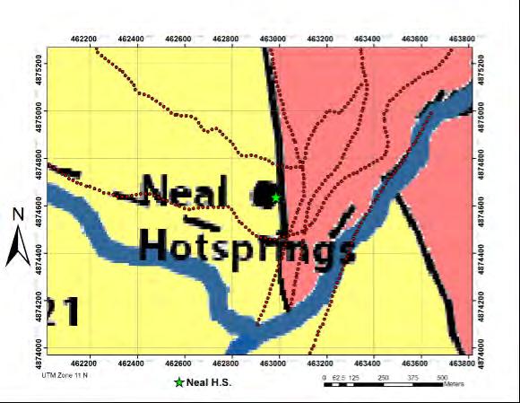
4 Locations Neal Hot Springs Upper Arkansas Valley
5 Finding Geothermal Resources Geophysics: Variety of properties to characterize resource Basic physical properties Imaging the subsurface structure Imaging fluids

6 Physical Properties Property Density Magnetic Susceptibility Conductivity Velocity Method Gravity, Seismic Magnetics DC Resistivity, Self Potential, Electromagnetic Seismic
7 General Surveying Tactics/Commentary Run lines perpendicular to (supposed) anomaly 3D vs. 2D Non-unique solutions = many methods Surface clues
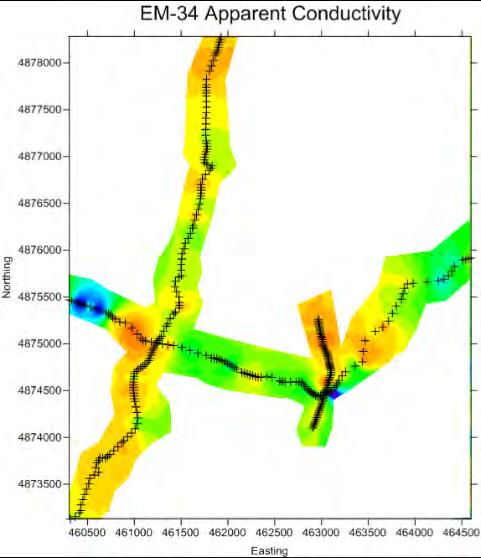
8 Neal Hot Springs Survey Lines Raynolds, 2011

9 Geophysics and Geothermal Systems Where is the hot water? How can it flow to the surface?
10 Figure: The set up and theory behind DC resistivity (Northwest Geophysical Associates Inc.) Where is the water? Inject current into ground Measure potential difference Calculate apparent resistivity Invert for resistivity/conductivity model Water = conductive! DC Resistivity
11 Self Potential Theory Revil, 2011


12 Self Potential Positive self potential anomaly Negative self potential anomaly

 current")
13 Frequency Domain Electromagnetics Transmitter coil (Tx) Receiver coil (Rx) current Primary field Secondary field


14 Time Domain Electromagnetics TEM acquisition setup from North Carolina Division of Water Resources Station 2 Central Sounding
15 Gravity Gravity: local subsurface density changes

16 Magnetics Magnetics: subsurface composition, magnetic susceptibility changes


17 Seismic Reflections from velocity contrast between beds


18 Upper Arkansas Valley Investigations Poncha Springs Courtesy of Dr. Andre Revil

19 Aeromagnetics V.J.S. Grauch & Benjamin Drenth, Airborne Geophysical Results, USGS, April 2009


20 Aeromagnetics N Poncha Springs Survey Area Aeromagnetic Map V.J.S. Grauch & Benjamin Drenth, Airborne Geophysical Results, USGS, April 2009
21 Aeromagnetics N Gradient Window Residual Analysis V.J.S. Grauch & Benjamin Drenth, Airborne Geophysical Results, USGS, April 2009

22 Aeromagnetics N Fault Interpretation V.J.S. Grauch & Benjamin Drenth, Airborne Geophysical Results, USGS, April 2009
23 Aeromagnetics N V.J.S. Grauch & Benjamin Drenth, Airborne Geophysical Results, USGS, April 2009

24 Joint Gravity, Magnetic and Seismic Interpretation N Survey Line Poncha Springs Google Earth Courtesy of Dr. Andre Revil

25 2009 Field Camp Deep Seismic Line
26 Grav, Mag, Seismic integration with GM-SYS under academic license for course use only

27 2009 Field Camp Gravity, Magnetics, and Seismic Joint Interpretation Grav, Mag, Seismic integration with GM-SYS under academic license for course use only

28 DC Resitivity and Self Potential Joint Interpretation N Chalk Cliffs Survey Line Google Earth
29 Temperature Data Self-Potential Data Resistivity Model Courtesy of Dr. Andre Revil

30 4±1 x10 3 m 3 /day of thermal water upwelling Courtesy of Dr. Andre Revil

31 Neal Hot Springs Investigation Raynolds, 2011
; Algorithm Teaching License")
32 Gravity 3D inversion of 2007 gravity data (Geothermal, Inc.). Inverted with Gzinv3d, created at UBC-GIF based on (Li and Oldenburg, 1998); Algorithm Teaching License provided to CSM-CGEM for academic use only.
; Algorithm Teaching License")
33 Gravity Raynolds, D inversion of 2007 gravity data (Geothermal, Inc.). Inverted with Gzinv3d, created at UBC-GIF based on (Li and Oldenburg, 1998); Algorithm Teaching License provided to CSM-CGEM for academic use only.
34 Gravity and Seismic Data Gravity

35 Neal Hot Spring EM Results

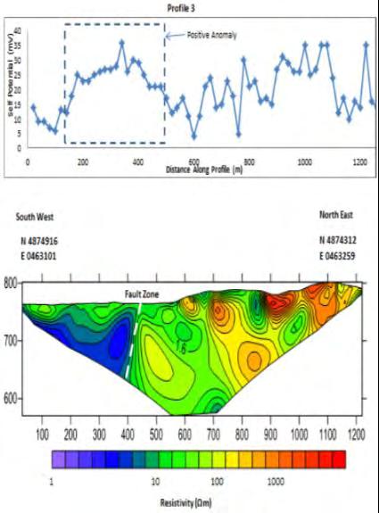
36 Resistivity: Profile 3 Results


37 Resistivity: Profile 3 Results SP Time-domain EM Resistivity Distance along profile (m)
38 Resistivity: Profile 4 Results SP Resistivity
39 What are we looking for? It s the fluids that count Mike Batzle M. Batzle. Fracturing and sealing in geothermal systems. PhD thesis, MIT, Cambridge, MA, 1978.
40 Using data to find Geothermal sources Courtesy of Andre Revil Grav, Mag, Seismic integration with GM-SYS under academic license for course use only

41 Correlation: Geology, Gravity, DC
42 Correlation is Confidence
Preliminary results for a near surface 3D seismic survey of a geothermal system in Colorado
 Preliminary results for a near surface 3D seismic survey of a geothermal system in Colorado Andrew Lamb 1, Kasper van Wijk 1, Lee Liberty 1, Mike Batzle 2, André Revil 2, Kyle Richards 2 and Chuck Diggins
GM 1.4. SEG/Houston 2005 Annual Meeting 639
 storage recovery project in Leyden, Colorado Kristofer Davis *, Yaoguo Li, Michael Batzle, and Bob Raynolds** Center for Gravity, Electrical, and Magnetic Studies, Department of Geophysics, Colorado School
2-D potential field modeling across the Hawtmi and Wiahatya faults in search of geothermal resources within the Umatilla Indian Reservation
 2-D potential field modeling across the Hawtmi and Wiahatya faults in search of geothermal resources within the Umatilla Indian Reservation Grober, Benjamin L. 1 & Palmer, Zachary A. 1 1 U.S. Geological
Integrated Geophysical Model for Suswa Geothermal Prospect using Resistivity, Seismics and Gravity Survey Data in Kenya
 Proceedings World Geothermal Congress 2015 Melbourne, Australia, 19-25 April 2015 Integrated Geophysical Model for Suswa Geothermal Prospect using Resistivity, Seismics and Gravity Survey Data in Kenya
TIME DOMAIN ELECTROMAGNETICS IN MARS ANALOG ENVIRONMENTS: COMPARING TWO FIELD STUDIES. Joern A. Jernsletten 1
 AAS 06-256 TIME DOMAIN ELECTROMAGNETICS IN MARS ANALOG ENVIRONMENTS: COMPARING TWO FIELD STUDIES Joern A. Jernsletten 1 The purpose of this study is to evaluate the use of (diffusive) Time Domain Electromagnetics
Geophysics for Geothermal Exploration
 Geophysics for Geothermal Exploration Dr. Hendra Grandis Geofisika - ITB Agenda Basic concept of Geophysics: : Review Geophysical signatures of a geothermal system Geophysical methods for geotermal exploration
National Geophysical Survey Science Opportunities
 National Geophysical Survey Science Opportunities Anton Ziolkowski Professor of Petroleum Geoscience University of Edinburgh BGS Keyworth 4 April 2016 Outline Brief biography Science opportunities High
3D Modeling for exploration
 3D Modeling for exploration Tero Niiranen Acting Division Manager Bedrock and Resources, GTK Rovaniemi office 02.05.2014 1 3D modeling supporting exploration in GTK Visualizing data in 3D world 3D geophysical
Overview of geophysical methods used in geophysical exploration
 Overview of geophysical methods used in geophysical exploration Lúdvík S. Georgsson United Nations University Geothermal Training Programme Orkustofnun Reykjavík ICELAND The role of the geophysicist Measuring
Geophysics Course Introduction to DC Resistivity
 NORAD supported project in MRRD covering Capacity Building and Institutional Cooperation in the field of Hydrogeology for Faryab Province Afghanistan Geophysics Course Introduction to DC Resistivity By
EOSC350 Environmental, Geotechnical and Exploration Geophysics I
 EOSC350 Environmental, Geotechnical and Exploration Geophysics I Geophysics for geoscience students & professionals. Slide 1 Introductions Geologists? Engineers? Other EOS? Other? Professionals? Instructor:
High Resolution Geophysics: A Better View of the Subsurface. By John Jansen, P.G., Ph.D., Aquifer Science and Technology
 High Resolution Geophysics: A Better View of the Subsurface By John Jansen, P.G., Ph.D., Aquifer Science and Technology Geologist Use Only Part of the Information Available To Them Most Geologist rely
Geophysics and Mapping. presented by: Stephen Brown
 Geophysics and Mapping presented by: Stephen Brown Recommended book for INIGEMM Geophysics for the mineral exploration geoscientist, by Michael Dentith and Stephen Mudge, Cambridge University Press, 2014.
Department of Geophysics Faculty of Earth Sciences King Abdulaziz University
 Department of Geophysics Faculty of Earth Sciences King Abdulaziz University Dr. Mansour A. Al-Garni Office: room 233/Buld. 27 OR Dept. chair office/buld. 55 Introduction to Geophysics EGP 211 Time: 10-10:55
ERDC/GSL TN-14-1 August 2014 Electromagnetic Induction Survey of the Mississippi River in Cleveland, Mississippi
 Electromagnetic Induction Survey of the Mississippi River in Cleveland, Mississippi By Joseph B. Dunbar and Maureen K. Corcoran PURPOSE: This study was conducted in support of Mississippi State University
USGS: USGS: NEIC NEIC
 Triggered Earthquakes in North-Central Arkansas and their Relationship to Class II UIC Wells Scott M. Ausbrooks, The Arkansas Geological Survey Steve Horton, Ph.D., CERI at University i of Memphis Contributors:
Keywords: geophysics field camp, low to moderate, temperature, geothermal system, Mt Pancar, Indonesia
 Proceedings World Geothermal Congress 2015 Melbourne, Australia, 19-25 April 2015 Geophysics Field Camp (GFC): A Student Project Aimed to Investigate the Low to Moderate Temperature Geothermal System in
Taller de Geotermica en Mexico Geothermal Energy Current Technologies
 Taller de Geotermica en Mexico Geothermal Energy Current Technologies presented by Paul Brophy, President/CEO EGS Inc. Mexico City October 10 th 2011 Presentation Topics General Geothermal Discussion Exploration
M.Sc. Track Petroleum Engineering & Geosciences
 M.Sc. Track Petroleum Engineering & Geosciences 3-9-2017 Delft University of Technology Challenge the future Challenging industry (and study) 2 Geothermal Energy Produce energy (heat) from subsurface for
 http://foundation.aapg.org/students/undergraduate/weeks.cfm Tim Carr - West Virginia University 3 Potential Fields Indirect Visualization Density and Magnetization Gravity and Magnetic Exploration Locate
CHANGES TO THE GEOLOGY & GEOPHYSICS PROGRAMS FOR
 CHANGES TO THE GEOLOGY & GEOPHYSICS PROGRAMS FOR 2018 19 For 2018 19, the changes are: (a) Geology 435 or Geology 441, geology and hydrogeology field courses, respectively, are added as required courses
Seismicity Associated with Geothermal Systems
 Seismicity Associated with Geothermal Systems Randi Walters: McNair Scholar Dr. Kasper van Wijk: Mentor Geosciences Abstract Studying natural and induced seismicity associated with geothermal systems can
Main Menu. Douglas Oldenburg University of British Columbia Vancouver, BC, Canada
 Using ERA low frequency E-field profiling and UBC 3D frequency-domain inversion to delineate and discover a mineralized zone in Porcupine district, Ontario, Canada. Vlad Kaminski* University of British
1D and 2D Inversion of the Magnetotelluric Data for Brine Bearing Structures Investigation
 1D and 2D Inversion of the Magnetotelluric Data for Brine Bearing Structures Investigation Behrooz Oskooi *, Isa Mansoori Kermanshahi * * Institute of Geophysics, University of Tehran, Tehran, Iran. boskooi@ut.ac.ir,
IRVING RESOURCES INC. 999 Canada Place, Suite 404 Vancouver, B.C., Canada V6C 3E2
 IRVING RESOURCES INC. 999 Canada Place, Suite 404 Vancouver, B.C., Canada V6C 3E2 NEWS RELEASE January 22, 2018 Irving Defines Strong Geophysical Anomalies at its Omu Gold-Silver Project, Hokkaido, Japan
RESISTIVITY IMAGING IN EASTERN NEVADA USING THE AUDIOMAGNETOTELLURIC METHOD FOR HYDROGEOLOGIC FRAMEWORK STUDIES. Abstract.
 RESISTIVITY IMAGING IN EASTERN NEVADA USING THE AUDIOMAGNETOTELLURIC METHOD FOR HYDROGEOLOGIC FRAMEWORK STUDIES Darcy K. McPhee, U.S. Geological Survey, Menlo Park, CA Louise Pellerin, Green Engineering,
Principles of Applied Geophysics
 Principles of Applied Geophysics Fifth edition D.S. Parasnis Professor emeritus of Applied Geophysics Department of Applied Geophysics, University ofluled, Lulea, Sweden Fellow of the Royal Swedish Academy
INTRODUCTION TO APPLIED GEOPHYSICS
 INTRODUCTION TO APPLIED GEOPHYSICS EXPLORING THE SHALL0W SUBSURFACE H. Robert Burger Anne F. Sheehan Craig H.Jones VERSITY OF COLORADO VERSITY OF COLORADO W. W. NORTON & COMPANY NEW YORK LONDON Contents
Constrained inversion of gravity and magnetic data: a real time exploration tool?
 Constrained inversion of gravity and magnetic data: a real time exploration tool? Hugh Miller Michael R. sh Michael Wheeler Colin G. Farquharson Department of Earth Sciences Memorial University of ewfoundland,
Application of sensitivity analysis in DC resistivity monitoring of SAGD steam chambers
 The University of British Columbia Geophysical Inversion Facility Application of sensitivity analysis in DC resistivity monitoring of SAGD steam chambers S. G. R. Devriese and D. W. Oldenburg gif.eos.ubc.ca
APPLIED GEOPHYSICS. MS in Petroleum Engineering. Semester 1, 2018/19 COURSE COMMUNICATION FOLDER
 APPLIED GEOPHYSICS MS in Petroleum Engineering Semester 1, 2018/19 COURSE COMMUNICATION FOLDER University of Miskolc Faculty of Earth Science and Engineering Institute of Geophysics and Geoinformatics
Airborne Geophysics to Map Groundwater. Bill Brown
 Airborne Geophysics to Map Groundwater Bill Brown bb@skytem.com A 6 borehole represents 1 millionth of an acre Aquifer Materials An aquifer is an underground layer of water bearing permeable rock, rock
ABSTRACT BACKGROUND ON THE FIELD SITE
 INTEGRATION OF GEOPHYSICAL MEASUREMENT TECHNIQUES IN THE EARLY STAGES OF SUSTAINABLE WATER SYSTEM DESIGN FOR THE DEVELOPING WORLD A Geoscientists Without Borders Project Final Report ABSTRACT We have used
Geothermal Energy Resources Exploration using Gravity and magnetics. By Mariita, N.O. KenGen
 Geothermal Energy Resources Exploration using Gravity and magnetics By Mariita, N.O. KenGen What is Geothermal Energy? Geothermal Energy = heat from the Earth Transmitted by fluids via fractures and pores
Raster Data Enhancement and Tectonic Element Interpretation in ArcMap
 Raster Data Enhancement and Tectonic Element Interpretation in ArcMap Vsevolod Egorov ESRI Petroleum User Group Conference Houston, TX 2005 Abstract ArcMap Spatial Analyst provides quick, but powerful
Geothermal Resource Prospecting in the Qualibou Caldera, Saint Lucia
 Geothermal Resource Prospecting in the Qualibou Caldera, Saint Lucia By Frank Dale Morgan Geo-Caraibes Technical Team & Massachusetts Institute of Technology March 2006 Outline History Summary Brief Review
Magnetic and Gravity Methods for Geothermal Exploration
 Magnetic and Gravity Methods for Geothermal Exploration Dr. Hendra Grandis Geophysics - ITB method and survey procedure Aero- or ground magnetic (covers a large area) Schlumberger resistivity mapping and
Ramping-up Exploration Value from Aeromagnetic Surveys - More Geological Input Needed!
 Ramping-up Exploration Value from Aeromagnetic Surveys - More Geological Input Needed! Dave Isles Southern Geoscience Consultants AIG Geoscientists Symposia Bali May 2013 EAST ASIA: Geology, Exploration
EOSC 350: Environmental, Geotechnical and Exploration Geophysics I
 EOSC 350: Environmental, Geotechnical and Exploration Geophysics I Geophysics for geoscience students & professionals. Slide 1 Introductions Geologists? Engineers? Other EOS? Other? Professionals? Instructor:
DATA ACQUISITION METHODS FOR GROUNDWATER INVESTIGATION AND THE SITING OF WATER SUPPLY WELLS
 DATA ACQUISITION METHODS FOR GROUNDWATER INVESTIGATION AND THE SITING OF WATER SUPPLY WELLS M.B.J. Foster Tetra Tech EM Inc., San Francisco, CA, USA Keywords: Groundwater, water wells, drilled wells, geophysical
Opportunities for Geothermal Development Created by New Technologies S2-1-2
 Opportunities for Geothermal Development Created by New Technologies S2-1-2 Geothermal Academy Masami Nakagawa Director of Geothermal Academy Fulbright Energy Specialist CSM/NREL Joint Appointee Department
Application of Transient Electromagnetics for the Investigation of a Geothermal Site in Tanzania
 Application of Transient Electromagnetics for the Investigation of a Geothermal Site in Tanzania Gerlinde Schaumann, Federal Institute for Geosciences and Natural Resources (BGR), Stilleweg 2, 30655 Hannover,
MT Prospecting. Map Resistivity. Determine Formations. Determine Structure. Targeted Drilling
 MT Prospecting Map Resistivity Determine Formations Determine Structure Targeted Drilling Cross-sectional interpretation before and after an MT survey of a mineral exploration prospect containing volcanic
INTEGRATED GEOPHYSICAL INTERPRETATION METHODS FOR HYDROCARBON EXPLORATION
 INTEGRATED GEOPHYSICAL INTERPRETATION METHODS FOR HYDROCARBON EXPLORATION Instructor : Kumar Ramachandran 31 July 4 August 2017 Jakarta COURSE OUTLINE The course is aimed at imparting working knowledge
Achieving depth resolution with gradient array survey data through transient electromagnetic inversion
 Achieving depth resolution with gradient array survey data through transient electromagnetic inversion Downloaded /1/17 to 128.189.118.. Redistribution subject to SEG license or copyright; see Terms of
The Role of Magnetotellurics in Geothermal Exploration
 The Role of Magnetotellurics in Geothermal Exploration Adele Manzella CNR - Via Moruzzi 1 56124 PISA, Italy manzella@igg.cnr.it Foreword MT is one of the most used geophysical methods for geothermal exploration.
Geothermal Systems: Geologic Origins of a Vast Energy Resource
 Geothermal Systems: Geologic Origins of a Vast Energy Resource Energy From the Earth Energy-Land-Water Connections Speaker Series James E. Faulds, PhD Nevada State Geologist and Professor Nevada Bureau
Exploration of Geothermal High Enthalpy Resources using Magnetotellurics an Example from Chile
 Exploration of Geothermal High Enthalpy Resources using Magnetotellurics an Example from Chile Ulrich Kalberkamp, Federal Institute for Geosciences and Natural Resources (BGR), Stilleweg 2, 30655 Hannover,
Report. On a 3D Magnetic Inversion. For. Cadillac Ventures Ltd. And. Newcastle Minerals Ltd. Pickle Lake Project. Ontario, Canada
 Report On a 3D Magnetic Inversion For Cadillac Ventures Ltd And Newcastle Minerals Ltd. Pickle Lake Project Ontario, Canada SCOTT HOGG & ASSOCIATES LTD October 2010 TABLE OF CONTENTS 1 INTRODUCTION...
Innovations in Airborne Exploration Geophysics. Benedikt Steiner
 Innovations in Airborne Exploration Geophysics Benedikt Steiner What is exploration geophysics? 2 The use of the Earth s physical properties in locating geological features of interest to mining. Magnetics,
Integrating potential field data with seismic, geochemistry and structural geology. Prepared for: Finding Petroleum
 Integrating potential field data with seismic, geochemistry and structural geology Prepared for: Finding Petroleum Contents Historical issues Non-integration Present day, integration Seismic planning Mapping
ENVIRONMENTAL AND ENGINEERING GEOPHYSICS
 ENVIRONMENTAL AND ENGINEERING GEOPHYSICS Environmental Engineering MSc 08/09 nd semester COURSE COMMUNICATION DOCUMENT University of Miskolc Faculty of Earth Science and Engineering Institute of Geophysics
Applications of geophysical inversions in mineral exploration
 Applications of geophysical inversions in mineral exploration I DOUGLAS W. OLDENBURG, YAOGUO LI, and COLIN G. FARQUHARSON, University of British Columbia PETER KOWALCZYK, Placer Dome, Incorporated, Vancouver,
DEPARTMENT OF GEOSCIENCES
 DEPARTMENT OF GEOSCIENCES Office in Natural Resources Building, Room 322 (970) 491-7826 warnercnr.colostate.edu/geosciences-home (http:// warnercnr.colostate.edu/geosciences-home) Richard Aster, Department
Lightning Data: the new EM seismic data
 Lightning Data: the new EM seismic data H. Roice Nelson, Jr. D. James Siebert L. R. Denham 08 November 2012 1 Electromagnetic Data maps the extent of natural resources Yellow: Red Sky 3-D seismic outline
Advances in airborne gravity gradiometry at Fugro Airborne Surveys
 Advances in airborne gravity gradiometry at Fugro Airborne Surveys M. Dransfield ( 1 ) ( 1 ) Fugro Airborne Surveys Summary In the last five years, considerable progress has been made in airborne gravity
Magnetotelluric (MT) Method
 Method") Magnetotelluric (MT) Method Dr. Hendra Grandis Graduate Program in Applied Geophysics Faculty of Mining and Petroleum Engineering ITB Geophysical Methods Techniques applying physical laws (or theory) to
Magnetotelluric (MT) Method Dr. Hendra Grandis Graduate Program in Applied Geophysics Faculty of Mining and Petroleum Engineering ITB Geophysical Methods Techniques applying physical laws (or theory) to
Novel approach to joint 3D inversion of EM and potential field data using Gramian constraints
 first break volume 34, April 2016 special topic Novel approach to joint 3D inversion of EM and potential field data using Gramian constraints Michael S. Zhdanov 1,2, Yue Zhu 2, Masashi Endo 1 and Yuri
BERG-HUGHES CENTER FOR PETROLEUM AND SEDIMENTARY SYSTEMS. Department of Geology and Geophysics College of Geosciences
 BERG-HUGHES CENTER FOR PETROLEUM AND SEDIMENTARY SYSTEMS Department of Geology and Geophysics College of Geosciences MISSION Integrate geoscience, engineering and other disciplines to collaborate with
Geophysical exploration methods at European sites
 Geophysical exploration methods at European sites David Bruhn, GFZ Potsdam, Section 5.2 Geothermics, 14473 Potsdam, Germany Most geophysical exploration methods have been developed for the oil and gas
Jonathan R. Major. BYU Department of Geological Sciences
 The tectonic evolution and regional significance of Kisar island, Indonesia: OR Early Orogeny Exposed Jonathan R. Major BYU Department of Geological Sciences Kisar is an anomaly Why Kisar? Located between
Spring 2018 Drill Program
 VANCOUVER, BC / April 5, 2018 / Margaret Lake Diamonds Inc. (TSX-V: DIA; FSE: M85) ("Margaret Lake" or the "Company") is pleased to report preparations are now underway to commence a diamond drill program
INTERGRATED GEOPHYSICAL METHODS USED TO SITE HIGH PRODUCER GEOTHERMAL WELLS
 Presented at Short Course VII on Exploration for Geothermal Resources, organized by UNU-GTP, GDC and KenGen, at Lake Bogoria and Lake Naivasha, Kenya, Oct. 27 Nov. 18, 2012. GEOTHERMAL TRAINING PROGRAMME
New Developments in Colorado Geothermal Energy Projects
 GRC Transactions, Vol. 36, 2012 New Developments in Colorado Geothermal Energy Projects John Hank Held and Fred Henderson III Mt. Princeton Geothermal LLC Keywords BLM lease sales, Colorado potential,
PUBLISHED VERSION.
 PUBLISHED VERSION S. Thiel, J.R. Peacock, J. MacFarlane and G. Heinson Electromagnetic monitoring of fluid injection - lessons learned Proceedings of the 2012 Australian Geothermal Energy Conference, 2012
Geophysics for Environmental and Geotechnical Applications
 Geophysics for Environmental and Geotechnical Applications Dr. Katherine Grote University of Wisconsin Eau Claire Why Use Geophysics? Improve the quality of site characterization (higher resolution and
CHANGES TO THE GEOLOGY & GEOPHYSICS PROGRAMS FOR March 15, 2017
 CHANGES TO THE GEOLOGY & GEOPHYSICS PROGRAMS FOR 2017 18 March 15, 2017 For 2017 18, the changes are: (a) Students in the Honours programs in Geology will be allowed to take either Geology 509 (Independent
Adam Tarte Holley. Postdoctoral Fellow Graduate Student Research Assistant Teaching Assistant
 Adam Tarte Holley aholley@tntech.edu 1908 Brown Ave. Cookeville, TN 38501 (919) 649-0273 Department of Physics Bruner Hall 222 110 University Drive Cookeville, TN 38501 (931) 372-3145 Academic Positions
Colorado s Underground Injection Control Program: Prevention and Mitigation of Induced Seismicity
 Colorado s Underground Injection Control Program: Prevention and Mitigation of Induced Seismicity Energy & Environment Symposium April 2015 Robert P. Koehler, PhD. UIC Lead OVERVIEW What is a UIC well?
FUNDAMENTALS OF ENGINEERING GEOLOGY
 FUNDAMENTALS OF ENGINEERING GEOLOGY Prof. Dr. HUSSEIN HAMEED KARIM Building and Construction Engineering Department 2012 Preface The impulse to write this book stemmed from a course of geology given by
PE OIL AND GAS EXPLORATION METHODS COURSE STRUCTURE. I. FUNDAMENTAL CONSIDERATIONS (5 Hrs.) III. SEISMIC REFLECTION METHOD
 III. SEISMIC REFLECTION METHOD") PE6050 - OIL AND GAS EXPLORATION METHODS Total Hours: 50 Faculty: Dr. Rajesh R Nair COURSE STRUCTURE I. FUNDAMENTAL CONSIDERATIONS (5 Hrs.) - Stress - Strain Relationship - Elastic Coefficients - Seismic
PE6050 - OIL AND GAS EXPLORATION METHODS Total Hours: 50 Faculty: Dr. Rajesh R Nair COURSE STRUCTURE I. FUNDAMENTAL CONSIDERATIONS (5 Hrs.) - Stress - Strain Relationship - Elastic Coefficients - Seismic
An Introduction to Geophysical Exploration
 An Introduction to Geophysical Exploration Philip Kearey Department of Earth Sciences University of Bristol Michael Brooks Ty Newydd, City Near Cowbridge Vale of Glamorgan Ian Hill Department of Geology
Horizontal gradient and band-pass filter of aeromagnetic data image the subsurface structure; Example from Esh El Mellaha Area, Gulf of Suez, Egypt.
 Horizontal gradient and band-pass filter of aeromagnetic data image the subsurface structure; Example from Esh El Mellaha Area, Gulf of Suez, Egypt. Essam Aboud 1, Serguei Goussev 2, Hassan Hassan 2, Suparno
Status of geothermal energy exploration at Buranga geothermal prospect, Western Uganda
 Status of geothermal energy exploration at Buranga geothermal prospect, Western Uganda ARGeo-C6, Addis Ababa 2016 James Francis Natukunda and Godfrey Bahati Ministry of Energy and Mineral Development Directorate
Use of Non-Invasive Near-Surface Geophysics for Managing Brine Releases
 Use of Non-Invasive Near-Surface Geophysics for Managing Brine Releases Presented by: Brent W. Barker, Staff Geophysicist Remediation Technologies Symposium 2012 Imagine the result Co-Authors Boyce L.
APPLICATION OF GEOPHYSICS TO GEOTHERMAL ENERGY EXPLORATION AND MONITORING OF ITS EXPLOITATION
 Presented at Short Course III on Exploration for Geothermal Resources, organized by UNU-GTP and KenGen, at Lake Naivasha, Kenya, October 24 - November 17, 2008. GEOTHERMAL TRAINING PROGRAMME Kenya Electricity
Towed Streamer EM Integrated interpretation for accurate characterization of the sub-surface. PETEX, Tuesday 15th of November 2016
 Towed Streamer EM Integrated interpretation for accurate characterization of the sub-surface. PETEX, Tuesday 15th of November 2016 Joshua May Sales and Marketing Manager Agenda Introduction to Towed Streamer
PRELIMINARY. Select Geophysical Methods and Groundwater Modeling: Examples from USGS studies. Claudia Faunt and a cast of others
 Select Geophysical Methods and Groundwater Modeling: Examples from USGS studies Claudia Faunt and a cast of others Current Preliminary Studies Stanford Water in the West Groundwater Data Workshop Series:
Mapping Silicification in Gold Exploration
 Mapping Silicification in Gold Exploration with Inductive Source Resistivity James Macnae and Patrick McGowan, Lamontagne Geophysics Ltd. Lamontagne Geophysics Ltd. 115 Grant Timmins Drive Kingston, Ontario
Life after Cal: Adapting to Change and Enjoying your Time in Graduate School
 Life after Cal: Adapting to Change and Enjoying your Time in Graduate School Tyler Seaman Fall 2013 http://eps.berkeley.edu/~brimhall/alumni_student_forum/website_alumni_student_forum.htm Outline! Background!
Applied Geophysics for Environmental Site Characterization and Remediation
 Applied Geophysics for Environmental Site Characterization and Remediation MSECA Webinar September 24, 2015 John Mundell, P.E., L.P.G. Ryan Brumbaugh, L.P.G. MUNDELL & ASSOCIATES, INC. Webinar Objective
Technical Requirements of Geothermal Exploration in the RSM DADI THORBJORNSON, RSM CONSULTANT WORKSHOP SWISS HOTEL IZMIR 5 JULY 2018
 Technical Requirements of Geothermal Exploration in the RSM DADI THORBJORNSON, RSM CONSULTANT WORKSHOP SWISS HOTEL IZMIR 5 JULY 2018 JV Partners Engineering firm with hundred twenty years of experience
Training the Next Generation of Geoscientists to Solve Realworld Environmental Problems using Advanced Techniques: Year Two Report
 Illinois State Geological Survey 615 E. Peabody Dr. Champaign, IL 61820 Training the Next Generation of Geoscientists to Solve Realworld Environmental Problems using Advanced Techniques: Year Two Report
Bachelor of Science in Geology
 Bachelor of Science in Geology 1 Bachelor of Science in Geology Why study geology? In Geology you get to apply techniques and knowledge from chemistry, physics, biology and math to answer important questions
Geophysics foundations: Seeing underground: Introduction
 Introduction Outline This five page article was written for those involved in the earth sciences who have no background in geophysics. It is intended to explain very briefly how applied geophysics can
Geophysical Methods for Screening and Investigating Utility Waste Landfill Sites in Karst Terrain
 Geophysical Methods for Screening and Investigating Utility Waste Landfill Sites in Karst Terrain Gary Pendergrass, PE, RG, F.NSPE Principal Geological Engineer Kansas City Geotechnical Conference 2017
FAQs - Earthquakes Induced by Fluid Injection
 of 1 http://earthquake.usgs.gov/learn/faq/?categoryid=46&faqid=357 4/23/2012 9:26 PM Q: Does the production of natural gas from shales cause earthquakes? If so, how are the earthquakes related to these
Optimizing Geophysical Inversions for Archean Orogenic Gold Settings
 Geophysical Inversion and Modeling Optimizing Geophysical Inversions for Archean Orogenic Gold Settings 1. University of British Columbia Paper 103 Mitchinson, D. E. [1], Phillips, N. D. [1] ABSTRACT Geophysical
UBC-GIF: Capabilities for EM Modelling and Inversion of LSBB data
 The University of British Colubia Geophysical Inversion Facility slide 1 UBC-GIF: Capabilities for EM Modelling and Inversion of LSBB data Douglas W. Oldenburg Departent of Earth and Ocean Sciences June
An investigation of Irish thermal springs: provenance, pathways and potential Sarah Blake
 An investigation of Irish thermal springs: provenance, pathways and potential Sarah Blake IRETHERM Workshop, Dublin 1 st April 2016 Thermal springs in Ireland Thermal springs in Ireland Thermal springs
Some New Developments in Rock Mechanics Research and Application
 Some New Developments in Rock Mechanics Research and Application Jian Zhao Wuhan University, 30 October 014 Developments in Rock Mechanics Research and Application Research Micromechanics and critical
Introducing the Stratagem EH4. Electrical Conductivity Imaging System Hybrid-Source Magnetotellurics
 Introducing the Stratagem EH4 Electrical Conductivity Imaging System Hybrid-Source Magnetotellurics Stratagem EH4 Hybrid-Source Magnetotellurics Frequency range of 10 Hz to 90k Hz Approx. depth of investigation
Seismic tomography with co-located soft data
 Seismic tomography with co-located soft data Mohammad Maysami and Robert G. Clapp ABSTRACT There is a wide range of uncertainties present in seismic data. Limited subsurface illumination is also common,
MESOZOIC BASINS. North Carolina Geological Survey
 MESOZOIC BASINS North Carolina Geological Survey The 1823 organic act which created the North Carolina Geological Survey (NCGS) tasked us to examine, describe and map the geology, geologic hazards, and
THREE DIMENSIONAL MODELING OF GEOELECTRICAL STRUCTURE BASED ON MT AND TDEM DATA IN MORI GEOTHERMAL FIELD, HOKKAIDO, JAPAN
 THREE DIMENSIONAL MODELING OF GEOELECTRICAL STRUCTURE BASED ON MT AND TDEM DATA IN MORI GEOTHERMAL FIELD, HOKKAIDO, JAPAN Tatsuya Kajiwara 1, Tohru Mogi 2, Elena Fomenko 3 and Sachio Ehara 4 1 JMC Geothermal
Enhanced remote earthquake triggering at fluid injection sites in the Midwestern US
 Enhanced remote earthquake triggering at fluid injection sites in the Midwestern US Nicholas van der Elst 1 Heather Savage 1 Katie Keranen 2 Geoff Abers 1 1 Lamont-Doherty Earth Observatory 2 Cornell University
Logistics Report on a BH UTEM 4 Survey in Elliot Lake, Ontario area for International Montoro Resources, Inc.
 Logistics Report on a BH UTEM 4 Survey in Elliot Lake, Ontario area for International Montoro Resources, Inc. Property Elliot Lake Boreholes P-15-22 June 2015 Bruce McMonnies, P.Geo. Christina Demerling,
Field Studies Class Summer 2016 By Maria Richards
 Field Studies Class Summer 2016 By Maria Richards The 2016 Field Studies Class traveled to Colorado, Wyoming, Montana, Idaho, Utah and back through Colorado to Dallas. It was two weeks of learning about
GEOTHERMAL POTENTIAL OF ST. KITTS AND NEVIS ISLANDS
 GEOTHERMAL POTENTIAL OF ST. KITTS AND NEVIS ISLANDS By Gerald W. Huttrer Geothermal Management Company, Inc. For the Eastern Caribbean Geothermal Energy Project ( Geo- Caraibes ; G-C ) Presented Using
VTEM-ZTEM Airborne EM Survey. Results over PGM-Cu-Ni Targets. at East Bull Lake Anorthositic Complex, Massey, ON
 KEGS-PDAC SYMPOSIUM 2011 Meeting Geophysical Challenges: Difficult Environments and Hard to Detect Commodities VTEM-ZTEM Airborne EM Survey Results over PGM-Cu-Ni Targets at East Bull Lake Anorthositic