Geothermal Resource Prospecting in the Qualibou Caldera, Saint Lucia
|
|
|
- Cecily Henderson
- 5 years ago
- Views:
Transcription
1 Geothermal Resource Prospecting in the Qualibou Caldera, Saint Lucia By Frank Dale Morgan Geo-Caraibes Technical Team & Massachusetts Institute of Technology March 2006
2
3 Outline History Summary Brief Review of Four MIT Studies Conclusion Recommendations
4 History Serious geothermal resource exploration began in the mid-70s by the British Geological Survey After dozens of investigations and nine drilled holes, no real geothermal development has resulted to date.
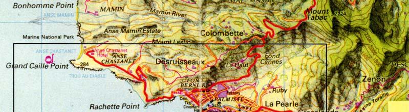
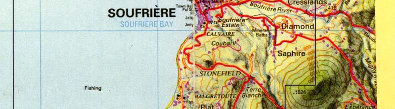
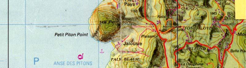
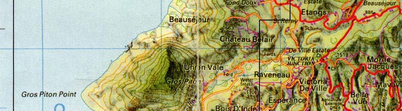
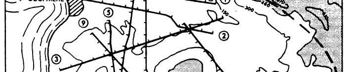
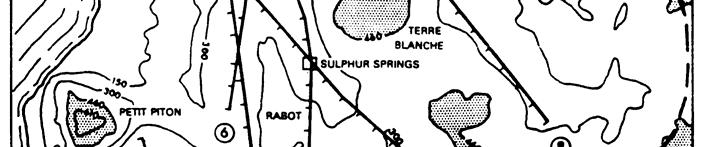
5 Historic Drill Site Recommendations Soufrière Bay Anse Des Pitons Gros Piton Petit Piton Soufrière Cresslands Diamond Terre Blanche Sulphur Springs Rabot Belfond Etangs Ravine Claire Fond St. Jacques Morne Bonin Belle Plaine UNRFNRE USAID DOE & USGS USAID LANL Gov t of St. Lucia GENZL & Aquater British Drilling Programme GENZL Kilometers Time Line 1951 British start formal investigation (Willmore) 1964 Tomblin performs detailed geology survey 1974 Institute of Geological Sciences (IGS) U.K. resistivity survey Seven wells drilled by IGS (Wells 1-7) 1976 Aspinall et al. perform seismic monitoring 1982 Aquater (Italy): Magnetotellurics, gravity, well data evaluation Los Alamos (USA): Geology, geochemistry, geophysics USAID/UN: Drill two deep wells (SL1 & SL2) 1992 Geothermal Energy New Zealand: Gravity, resistivity, audio magnetotelluric resistivity 1998-Pesent 2004-Present M.I.T.: Reinterpretation of British resistivity data, self potential geophysics, decision analysis United Network of the Eastern Caribbean is commissioned to develop geothermal resources.


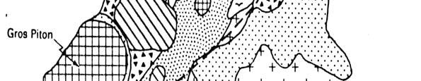

6 Geology
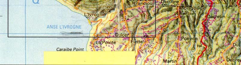
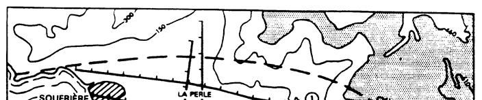
7 Geothermal Wells & Hot Springs Soufriere Bay Petit Piton Gros Piton

8 GENZL, 1992 USAID (Aquater), 1987
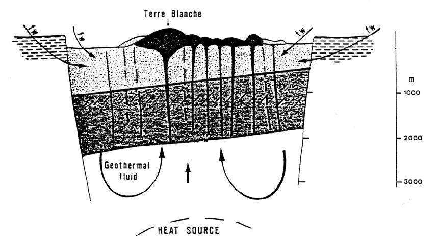
9 Summary Very complex geology and hydrogeology The chemistry of the geothermal waters beneath the Sulphur Springs is quite severe. The geothermal reservoir cap rocks are weak. Exploration is best optimized by exploring for less hot but less corrosive waters away from the Sulphur Springs.
10 Synopsis of Four MIT Studies Reinterpretation of the British Line 9 resistivity data. 3D rendering of 2D resistivity inversions. Self Potential surveying. Geological/Geophysical data integration using a decision analysis method.
11 Reinterpretation of the British Line 9 Resistivity Data. Data collected in 1974 by Lee and Greenwood, British Geological Survey
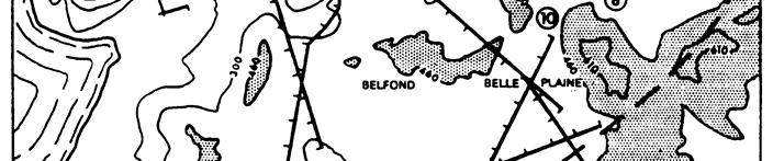
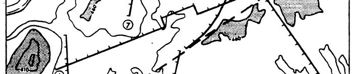
12 9
13 Depth (m) Sulphur Springs (1974) SL Sulphur Springs (2002) SL-2 Depth (m) Log Resistivity (ohm-m)

14 2 Sulphur Springs SL-2 SL ohm-m 150 o C 30 ohm-m 250 o 30 to 1000 ohm-m C
15 3D Rendering of 2D Resistivity Inversions. All the British resistivity lines were inverted into 2D cross-sections and then rendered into 3D.

16 3D Resistivity Tomogram Southeast -to- Northwest

17 3D Resistivity Tomogram Northeast -to- Southwest
18 Self Potential Surveying Small, millivolt electrical potentials were mapped, processed and interpreted throughout the Qualibou Caldera.
19 Fond St. Jacques SP Survey Lines 3 Cressland Diamond. Malgretoute Sulphur Springs Belfond Main
20 Individual SP Lines Self Potential Fond St. Jacques Cresslands Diamond Sulphur Springs Rabot Belfond Malgretoute Distance
21 N Correlation of observed SP anomalies and fault locations.

22 Interpolated SP Data mv Sulphur Springs
23 Geological/Geophysical Data Integration Using a Decision Analysis Method. Eleven disparate data sets were jointly analyzed by a decision analysis methodology to determine possible drilling locations.
 Target Region Discretized Caldera Example Data Map Eleven datasets were used: Seismics, self potentials, fault structure, deep resistivity, shallow resistivity,")
24 Method Re-interpreted British Resistivity 700m BGS 0 km 3 km 6 km Morgan et al., (2002) Target Region Discretized Caldera Example Data Map Eleven datasets were used: Seismics, self potentials, fault structure, deep resistivity, shallow resistivity, geology, topography, wells/springs/geochemistry, shallow AMT, deep AMT, and residual gravity.

25 Group Result X 4 Cresslands Diamond Malgretoute X 6 X 3 X Sulphur 1 Springs X 2 X 5 Etangs
26 Conclusion Geothermal resource exploration in Saint Lucia is a very difficult endeavor because of: Geological complexity Highly corrosive geothermal waters.
27 Recommendations Explore for drilling locations away from the Sulphur Springs to balance improved water chemistry with lower temperatures. The probability of success will increase substantially by doing 3D resistivity/selfpotential geophysics to accurately locate drilling positions and to avoid the faux pas of the past.
Summary of geothermal setting in Geo-Caraïbes target islands
 Summary of geothermal setting in Geo-Caraïbes target islands Dr Simon R Young Consultant to OAS Presentation made at the Guadeloupe workshop, 27 April 2004 St Lucia - overview Only one broad target area
GEOTHERMAL POTENTIAL OF ST. KITTS AND NEVIS ISLANDS
 GEOTHERMAL POTENTIAL OF ST. KITTS AND NEVIS ISLANDS By Gerald W. Huttrer Geothermal Management Company, Inc. For the Eastern Caribbean Geothermal Energy Project ( Geo- Caraibes ; G-C ) Presented Using
Identified a possible new offset location where the customer is currently exploring drill options.
 GroundMetrics was hired to conduct a Full-Field Resistivity Survey for an oil and gas producer that needed to make crucial decisions to drive profitability at the location. The results saved them hundreds
Outcomes of the Workshop on the Geologic and Geothermal Development of the Western Branch of the Greater East African Rift System
 Outcomes of the Workshop on the Geologic and Geothermal Development of the Western Branch of the Greater East African Rift System East Africa Donor Coordination Meeting 14 June 2016 AUC Headquarter Addis
Keywords: geophysics field camp, low to moderate, temperature, geothermal system, Mt Pancar, Indonesia
 Proceedings World Geothermal Congress 2015 Melbourne, Australia, 19-25 April 2015 Geophysics Field Camp (GFC): A Student Project Aimed to Investigate the Low to Moderate Temperature Geothermal System in
National Geophysical Survey Science Opportunities
 National Geophysical Survey Science Opportunities Anton Ziolkowski Professor of Petroleum Geoscience University of Edinburgh BGS Keyworth 4 April 2016 Outline Brief biography Science opportunities High
DÉCOUVERTE Positioned for Discovery in James Bay, Quebec. Investor Presentation, January 2018 by Danae Voormeij, MSc, PGeo
 DÉCOUVERTE Positioned for Discovery in James Bay, Quebec Investor Presentation, January 2018 by Danae Voormeij, MSc, PGeo Location Maps and Infrastructure Location: Durango Resources 100% owned Découverte
Imaging Reservoir Structure of Mt. Pancar Geothermal Prospect Using Audio-Frequency Magnetotelluric (AMT) and Gravity Technology
 and Gravity Technology") PROCEEDINGS, 42nd Workshop on Geothermal Reservoir Engineering Stanford University, Stanford, California, February 13-15, 2017 SGP-TR-212 Imaging Reservoir Structure of Mt. Pancar Geothermal Prospect Using
PROCEEDINGS, 42nd Workshop on Geothermal Reservoir Engineering Stanford University, Stanford, California, February 13-15, 2017 SGP-TR-212 Imaging Reservoir Structure of Mt. Pancar Geothermal Prospect Using
HIGH TEMPERATURE HYDROTHERMAL ALTERATION IN ACTIVE GEOTHERMAL SYSTEMS A CASE STUDY OF OLKARIA DOMES
 Proceedings, 6 th African Rift Geothermal Conference Addis Ababa, Ethiopia, 2 nd 4 th November 2016 HIGH TEMPERATURE HYDROTHERMAL ALTERATION IN ACTIVE GEOTHERMAL SYSTEMS A CASE STUDY OF OLKARIA DOMES James
INTERGRATED GEOPHYSICAL METHODS USED TO SITE HIGH PRODUCER GEOTHERMAL WELLS
 Presented at Short Course VII on Exploration for Geothermal Resources, organized by UNU-GTP, GDC and KenGen, at Lake Bogoria and Lake Naivasha, Kenya, Oct. 27 Nov. 18, 2012. GEOTHERMAL TRAINING PROGRAMME
Outcomes of the Workshop on the Geologic and Geothermal Development of the Western Branch of the Greater East African Rift System
 Outcomes of the Workshop on the Geologic and Geothermal Development of the Western Branch of the Greater East African Rift System Energy Ministerial Meeting 13 June 2016 AUC Headquarter Addis Ababa, Ethiopia
James Francis Natukunda
 James Francis Natukunda Department of Geological Surveys and Mines Ministry of Energy and Mineral Development, Uganda Regional stakeholders workshop for EARS countries and partners Nairobo, Kenya 15-17
Taller de Geotermica en Mexico Geothermal Energy Current Technologies
 Taller de Geotermica en Mexico Geothermal Energy Current Technologies presented by Paul Brophy, President/CEO EGS Inc. Mexico City October 10 th 2011 Presentation Topics General Geothermal Discussion Exploration
APPLICATION OF GEOPHYSICS TO GEOTHERMAL ENERGY EXPLORATION AND MONITORING OF ITS EXPLOITATION
 Presented at Short Course III on Exploration for Geothermal Resources, organized by UNU-GTP and KenGen, at Lake Naivasha, Kenya, October 24 - November 17, 2008. GEOTHERMAL TRAINING PROGRAMME Kenya Electricity
MT Prospecting. Map Resistivity. Determine Formations. Determine Structure. Targeted Drilling
 MT Prospecting Map Resistivity Determine Formations Determine Structure Targeted Drilling Cross-sectional interpretation before and after an MT survey of a mineral exploration prospect containing volcanic
Geothermal Exploration in Eritrea
 Geothermal Exploration in Eritrea Short Course III on Exploration for Geothermal Resources November 2008, Naivasha, Kenya Ermias Yohannes Berhane Ermias_yohannes@yahoo.com Ministry of Energy and Mines
Geophysics for Geothermal Exploration
 Geophysics for Geothermal Exploration Dr. Hendra Grandis Geofisika - ITB Agenda Basic concept of Geophysics: : Review Geophysical signatures of a geothermal system Geophysical methods for geotermal exploration
Belgian Geological data for deep geothermal Energy
 Belgian Geological data for deep geothermal Energy Estelle Petitclerc, Michiel Dusar Geological Survey of Belgium (GSB) Contact: estelle.petitclerc@naturalsciences.be Utrecht, January 24 th, 2012 Available
Geothermal Potential of the Kenya Rift: energy estimates based on new data. Peter Omenda and Silas Simiyu KenGen
 Geothermal Potential of the Kenya Rift: energy estimates based on new data Peter Omenda and Silas Simiyu KenGen 1 Introduction Kenya relies on three major sources of energy in the electricity sub sector:
GEOTHERMAL ENERGY POTENTIAL FOR LONGONOT PROSPECT, KENYA. By Mariita N. O. Kenya Electricity Generating Company
 GEOTHERMAL ENERGY POTENTIAL FOR LONGONOT PROSPECT, KENYA By Mariita N. O. Kenya Electricity Generating Company PRESENTATION OUTLINE INTRODUCTION REGIONAL SETTING GEOLOGY GEOTHERMAL MANIFESTATIONS HYDROGEOLOGY
Integrated interpretation of multimodal geophysical data for exploration of geothermal resources Case study: Yamagawa geothermal field in Japan
 Integrated interpretation of multimodal geophysical data for exploration of geothermal resources Case study: Yamagawa geothermal field in Japan Masashi Endo*(TechnoImaging), Alex Gribenko (TechnoImaging
Geophysical exploration methods at European sites
 Geophysical exploration methods at European sites David Bruhn, GFZ Potsdam, Section 5.2 Geothermics, 14473 Potsdam, Germany Most geophysical exploration methods have been developed for the oil and gas
Geo-scientific Data Integration to Evaluate Geothermal Potential Using GIS (A Case for Korosi-Chepchuk Geothermal Prospects, Kenya)
") Geo-scientific Data Integration to Evaluate Geothermal Potential Using GIS (A Case for Korosi-Chepchuk Geothermal Prospects, Kenya) Levi Shako and Joseph Mutua Geothermal Development Company, P. O. Box
Geo-scientific Data Integration to Evaluate Geothermal Potential Using GIS (A Case for Korosi-Chepchuk Geothermal Prospects, Kenya) Levi Shako and Joseph Mutua Geothermal Development Company, P. O. Box
Geophysics and Geothermal Energy. Joseph Capriotti Meghan Helper Kendra Johnson Patricia Littman Gordon Osterman
 Geophysics and Geothermal Energy Joseph Capriotti Meghan Helper Kendra Johnson Patricia Littman Gordon Osterman Colorado School of Mines End of students junior year 4 week field camp Learning experience
Resistivity structure of Sumikawa geothermal field, northeastern Japan, obtained from magnetotelluric data. Toshihiro Uchida
 Resistivity structure of Sumikawa geothermal field, northeastern Japan, obtained from magnetotelluric data Toshihiro Geological Survey of Japan 1-1-3 Higashi, Tsukuba, Ibaraki 35, Japan ABSTRACT: Resistivity
Determination of Geothermal Gradient in the Eastern Niger Delta Sedimentary Basin from Bottom Hole Temperatures
 Journal of Earth Sciences and Geotechnical Engineering, vol. 4, no. 3, 2014, 109-114 ISSN: 1792-9040 (print), 1792-9660 (online) Scienpress Ltd, 2014 Determination of Geothermal Gradient in the Eastern
MESOZOIC BASINS. North Carolina Geological Survey
 MESOZOIC BASINS North Carolina Geological Survey The 1823 organic act which created the North Carolina Geological Survey (NCGS) tasked us to examine, describe and map the geology, geologic hazards, and
Geothermal Exploration in Eritrea
 Geothermal Exploration in Eritrea Ermias Yohannes, Eritrea Ministry of Energy and Mines, Department of Mines ermias_yohannes@yahoo.com Short Course on Surface Exploration for Geothermal Resources UNU-GTP
RESERVOIR MODELING & CHARACTERIZATION TOOLS: APPLYING METHODS & TOOLS FROM THE OIL AND GAS INDUSTRY TO ENHANCE GEOTHERMAL RESOURCES.
 RESERVOIR MODELING & CHARACTERIZATION TOOLS: APPLYING METHODS & TOOLS FROM THE OIL AND GAS INDUSTRY TO ENHANCE GEOTHERMAL RESOURCES Jacques CHOURAKI 1 NEW TOOLS & METHODS CURRENTLY, GEOSCIENTIFIC STUDIES,
ASSESSMENT OF GEOTHERMAL POTENTIAL AT UNGARAN VOLCANO, INDONESIA DEDUCED FROM NUMERICAL ANALYSIS
 PROCEEDINGS, Thirty-Fourth Workshop on Geothermal Reservoir Engineering Stanford University, Stanford, California, February 9-11, 2009 SGP-TR-187 ASSESSMENT OF GEOTHERMAL POTENTIAL AT UNGARAN VOLCANO,
RESISTIVITY IMAGING IN EASTERN NEVADA USING THE AUDIOMAGNETOTELLURIC METHOD FOR HYDROGEOLOGIC FRAMEWORK STUDIES. Abstract.
 RESISTIVITY IMAGING IN EASTERN NEVADA USING THE AUDIOMAGNETOTELLURIC METHOD FOR HYDROGEOLOGIC FRAMEWORK STUDIES Darcy K. McPhee, U.S. Geological Survey, Menlo Park, CA Louise Pellerin, Green Engineering,
STATE OF KNOWLEDGE OF THE GEOTHERMAL PROVINCES OF REPUBLIC OF DJIBOUTI
 STATE OF KNOWLEDGE OF THE GEOTHERMAL PROVINCES OF REPUBLIC OF DJIBOUTI UNU training KENGEN Naivasha, Kenya, November 2007 JALLUDIN Mohamed Djibouti, CERD GEOTHERMAL EXPLORATIONS IN DJIBOUTI FIRST PHASE
Assessing our untapped energy resources. Derek Reay Geological Survey of Northern Ireland
 Assessing our untapped energy resources Derek Reay Geological Survey of Northern Ireland Talk Outline Northern Ireland energy market Oil and Gas Exploration Description Exploration risks Application of
The Role of Magnetotellurics in Geothermal Exploration
 The Role of Magnetotellurics in Geothermal Exploration Adele Manzella CNR - Via Moruzzi 1 56124 PISA, Italy manzella@igg.cnr.it Foreword MT is one of the most used geophysical methods for geothermal exploration.
NT RESOURCES LIMITED QUARTERLY ACTIVITIES REPORT FOR THE PERIOD ENDED 30 JUNE 2010 ASX CODE: NTR
 NT RESOURCES LIMITED QUARTERLY ACTIVITIES REPORT FOR THE PERIOD ENDED 30 JUNE 2010 ASX CODE: NTR Activities Report Background NT Resources Limited ( NT Resources or the Company ) holds six granted Exploration
1.0 Introduction 1.1 Geographic Location 1.2 Topography 1.3 Climate and Rainfall 1.4 Geology and Hydrogeology 1.5 Water Availability 1.
 1.0 1.1 Geographic Location 1.2 Topography 1.3 Climate and Rainfall 1.4 Geology and Hydrogeology 1.5 Water Availability 1.6 Demography 1.0 1.1 Geographic Location St. Lucia forms part of an archipelago
Integrated Geophysical Model for Suswa Geothermal Prospect using Resistivity, Seismics and Gravity Survey Data in Kenya
 Proceedings World Geothermal Congress 2015 Melbourne, Australia, 19-25 April 2015 Integrated Geophysical Model for Suswa Geothermal Prospect using Resistivity, Seismics and Gravity Survey Data in Kenya
CERD GEOTHERMAL EXPLORATIONS AND RESULTS IN THE REPUBLIC OF DJIBOUTI. Short Course Naivasha, Kenya, November 2006
 GEOTHERMAL EXPLORATIONS AND RESULTS IN THE REPUBLIC OF DJIBOUTI Short Course Naivasha, Kenya, 11-22 November 2006 JALLUDIN Mohamed Djibouti, CERD PRESENTATION PLAN General geological and hydrothermal activity
Application of Transient Electromagnetics for the Investigation of a Geothermal Site in Tanzania
 Application of Transient Electromagnetics for the Investigation of a Geothermal Site in Tanzania Gerlinde Schaumann, Federal Institute for Geosciences and Natural Resources (BGR), Stilleweg 2, 30655 Hannover,
Geophysical Surveys of The Geothermal System of The Lakes District Rift, Ethiopia
 Geophysical Surveys of The Geothermal System of The Lakes District Rift, Ethiopia By: Befekadu Oluma By: Geophysics Department Geological Survey of Ethiopia The formation of the rift was preceded by a
NISYROS GEOTHERMAL ENERGY UTILIZATION PREFEASIBILITY STUDY. A briefing paper By Costas Karytsas CRES
 NISYROS GEO ENERGY UTILIZATION PREFEASIBILITY STUDY A briefing paper By Costas Karytsas CRES Nisyros is a small island with an active volcano in the Eastern edge of the South Aegean volcanic arc. It covers
Mount Spurr geothermal workshop August 27 28, 2007
 Mount Spurr geothermal workshop August 27 28, 2007 Geologic Overview & Review of Geothermal Exploration Christopher Nye geologist / volcanologist DNR/GGS & AVO Alaska Division of Geological and Geophysical
GEOTHERMAL WELL SITING USING GIS: A CASE STUDY OF MENENGAI GEOTHERMAL PROSPECT
 GEOTHERMAL WELL SITING USING GIS: A CASE STUDY OF MENENGAI GEOTHERMAL PROSPECT Levi Shako Geothermal Development Company P. O Box 17700-20100, Nakuru, Kenya. lshako@gdc.co.ke ABSTRACT Geothermal well site
2-D potential field modeling across the Hawtmi and Wiahatya faults in search of geothermal resources within the Umatilla Indian Reservation
 2-D potential field modeling across the Hawtmi and Wiahatya faults in search of geothermal resources within the Umatilla Indian Reservation Grober, Benjamin L. 1 & Palmer, Zachary A. 1 1 U.S. Geological
CERD STATE OF KNOWLEDGE OF THE GEOTHERMAL PROVINCES OF REPUBLIC OF DJIBOUTI. ARGEO-C1 Conference Addis-Ababa, Ethiopia, November 2006
 STATE OF KNOWLEDGE OF THE GEOTHERMAL PROVINCES OF REPUBLIC OF DJIBOUTI ARGEO-C1 Conference Addis-Ababa, Ethiopia, 24-29 November 2006 JALLUDIN Mohamed Djibouti, GEOTHERMAL EXPLORATIONS IN DJIBOUTI FIRST
Relinquishment Report for Licence Number P1356, Block 48/8c March 2008
 Relinquishment Report for Licence Number P1356, Block 48/8c March 2008 Table of Contents 1.0 Header...3 2.0 Synopsis...3 3.0 Exploration Activities...4 4.0 Prospectivity Analysis...11 5.0 Conclusions...12
Groundwater Level Monitoring of the Quaternary Aquifer at Al Ain City, United Arab Emirates (UAE) using Geophysical Methods
 using Geophysical Methods") Groundwater Level Monitoring of the Quaternary Aquifer at Al Ain City, United Arab Emirates (UAE) using Geophysical Methods Ahmed Murad & Amir Gabr Geology Department UAE University Outlines Introduction
Groundwater Level Monitoring of the Quaternary Aquifer at Al Ain City, United Arab Emirates (UAE) using Geophysical Methods Ahmed Murad & Amir Gabr Geology Department UAE University Outlines Introduction
Figure 1: Location of principal shallow conductors at Alpala (anomalies C0-C10; 5 Ohm/m surfaces, red) and shallow zones of electrical chargeability
 and shallow zones of electrical chargeability") Figure 1: Location of principal shallow conductors at Alpala (anomalies C0-C10; 5 Ohm/m surfaces, red) and shallow zones of electrical chargeability (85 msecs, yellow-green) shown on iso-surfaces of MVI
Figure 1: Location of principal shallow conductors at Alpala (anomalies C0-C10; 5 Ohm/m surfaces, red) and shallow zones of electrical chargeability (85 msecs, yellow-green) shown on iso-surfaces of MVI
Exploring for geothermal reservoirs using broadband 2-D MT and gravity in Hungary
 KMS Technologies KJT Enterprises Inc. An EMGS/RXT company Exploring for geothermal reservoirs using broadband 2-D MT and gravity in Hungary Tulinius, H., Adám, L., Halldórsdóttir, H.,Yu, G., Strack, K.
Geophysical Exploration of the Western Saudi Arabian Geothermal Province: First Results from the Al-Lith Area
 Proceedings World Geothermal Congress 2015 Melbourne, Australia, 19-25 April 2015 Geophysical Exploration of the Western Saudi Arabian Geothermal Province: First Results from the Al-Lith Area Aref Lashin
Three-dimensional geophysical modelling of the Alalobeda geothermal field
 Three-dimensional geophysical modelling of the Alalobeda geothermal field Daniele Rizzello 1, Egidio Armadillo 2, Claudio Pasqua 2,3, Massimo Verdoya 2, Solomon Kebede 4, Andarge Mengiste 4, Getenesh H/Giorgis
Geophysical Exploration of High Temperature Geothermal Areas using Resistivity Methods. Case Study: TheistareykirArea, NE Iceland
 Proceedings World Geothermal Congress 2015 Melbourne, Australia, 19-25 April 2015 Geophysical Exploration of High Temperature Geothermal Areas using Resistivity Methods. Case Study: TheistareykirArea,
Does the SDCP need inputs from geology?
 The British Geological Survey s Experience and Expertise in Supporting Projects such as the Sirte Depression Connection Project David Ovadia Director of International Kingsley Dunham Centre Keyworth Nottingham
NOTICE CONCERNING COPYRIGHT RESTRICTIONS
 NOTICE CONCERNING COPYRIGHT RESTRICTIONS This document may contain copyrighted materials. These materials have been made available for use in research, teaching, and private study, but may not be used
Airborne gravity gradiometer surveying of petroleum systems under Lake Tanganyika, Tanzania
 Airborne gravity gradiometer surveying of petroleum systems under Lake Tanganyika, Tanzania D. Roberts Beach Energy P. Roy Chowdhury CGG S. J. Lowe CGG A. N. Christensen CGG Outline Introduction Geology
Geophysical Survey Interpretation Report
 116 Spadina Ave., Suite 400 Toronto, ON, M5V 2K6 Phone (416) 306 1941 Fax (416) 306 1949 Geophysical Survey Interpretation Report Quantec Titan-24 Distributed Acquisition System DC RESISTIVITY & INDUCED
Exploration of Geothermal High Enthalpy Resources using Magnetotellurics an Example from Chile
 Exploration of Geothermal High Enthalpy Resources using Magnetotellurics an Example from Chile Ulrich Kalberkamp, Federal Institute for Geosciences and Natural Resources (BGR), Stilleweg 2, 30655 Hannover,
P1488 DECC Relinquishment Report OMV (U.K.) Ltd.
 Ltd.") 1. Synopsis: P1488 DECC Relinquishment Report OMV (U.K.) Ltd. UK offshore Licence P1488 was awarded to OMV, Dana Petroleum and Rocksource in the 24 th Licence Round on the 24 th of January 2007 as a frontier
1. Synopsis: P1488 DECC Relinquishment Report OMV (U.K.) Ltd. UK offshore Licence P1488 was awarded to OMV, Dana Petroleum and Rocksource in the 24 th Licence Round on the 24 th of January 2007 as a frontier
Geothermal potential Studies Spain
 Geothermal potential Studies Spain Petratherm España s.l. GEOELEC WORKSHOP 10-11-2011 VALENCIA Raúl Hidalgo Global Corporate overview Our company Leading Australian geothermal exploration and development
Accurate reservoir modelling through optimized integration of geostatistical inversion and flow simulation. A North Sea case study.
 Accurate reservoir modelling through optimized integration of geostatistical inversion and flow simulation. A North Sea case study. A. Castoro 1, L de Groot 2, D. Forsyth 3 & R. Maguire 1 1 Fugro-Jason
INTEGRATED GEOPHYSICAL STUDIES OF THE ULUBELU GEOTHERMAL FIELD, SOUTH SUMATERA, INDONESIA
 ITEGATED GEOPHYSICAL STUDIES OF THE ULUBELU GEOTHEMAL FIELD, SOUTH SUMATEA, IDOESIA Yunus Daud 1, Sayogi Sudarman 2, Keisuke Ushijima 1 1 Exploration Geophysics Lab., Fac. of Engineering, Kyushu University,
Technologies and Applications of Geophysical Exploration in Deep Geothermal Resources in China
 Proceedings World Geothermal Congress 2015 Melbourne, Australia, 19-25 April 2015 Technologies and Applications of Geophysical Exploration in Deep Geothermal Resources in China Long Hui, Zhu Qingjun, Tian
Source Body Migration, an Approximate Inversion Method for Full Tensor Gravity Gradiometer Data
 Source Body Migration, an Approximate Inversion Method for Full Tensor Gravity Gradiometer Data James Brewster, Alan Morgan, and John Mims * Bell Geospace Inc., 400 N. Sam Houston Pkwy E., Ste. 325, Houston,
GRAVITY AND MAGNETIC SURVEY NECHAKO BASIN STUDY ACQUISITION AND PROCESSING PHASE
 GRAVITY AND MAGNETIC SURVEY NECHAKO BASIN STUDY ACQUISITION AND PROCESSING PHASE Report prepared for the B.C. Ministry of Energy and Mines Resource Development Division New Ventures Branch by Bemex Consulting
3D MAGNETOTELLURIC SURVEY AT THE YANAIZU-NISHIYAMA GEOTHERMAL FIELD, NORTHERN JAPAN
 3D MAGNETOTELLURIC SURVEY AT THE YANAIZU-NISHIYAMA GEOTHERMAL FIELD, NORTHERN JAPAN Toshihiro Uchida 1, Shinichi Takakura 1, Takumi Ueda 1, Masaho Adachi 2, Hitoshi Ozeki 2, Kunikazu Kamada 3, Tatsuya
Relinquishment Report. Licence P1616. Block 21/12b
 Relinquishment Report Licence P1616 Block 21/12b EOG Resources United Kingdom Limited March 2014 List of Contents 1. Licence information 2. Licence Synopsis 3. Work Programme Summary 4. Database 5. Further
Preliminary results for a near surface 3D seismic survey of a geothermal system in Colorado
 Preliminary results for a near surface 3D seismic survey of a geothermal system in Colorado Andrew Lamb 1, Kasper van Wijk 1, Lee Liberty 1, Mike Batzle 2, André Revil 2, Kyle Richards 2 and Chuck Diggins
UK data for geothermal resource assessments
 UK data for geothermal resource assessments Jon Busby UK data for geothermal resource assessments Outline 1. Data availability 2. Sub-surface temperatures 3. The EGS resource 4. Deep saline aquifers Publicly
THE UNIVERSITY OF HONG KONG LIBRARIES. Hong Kong Collection. gift from Hong Kong (China). Geotechnical Engineering Office.
. Geotechnical Engineering Office.") THE UNIVERSITY OF HONG KONG LIBRARIES Hong Kong Collection gift from Hong Kong (China). Geotechnical Engineering Office. Geotechnical Engineering Office, Civil Engineering Department The Government of
THE UNIVERSITY OF HONG KONG LIBRARIES Hong Kong Collection gift from Hong Kong (China). Geotechnical Engineering Office. Geotechnical Engineering Office, Civil Engineering Department The Government of
NUMERICAL MODELING STUDY OF SIBAYAK GEOTHERMAL RESERVOIR, NORTH SUMATRA, INDONESIA
 PROCEEDINGS, Twenty-Sixth Workshop on Geothermal Reservoir Engineering Stanford University, Stanford, California, January 29-31, 21 SGP-TR-168 NUMERICAL MODELING STUDY OF SIBAYAK GEOTHERMAL RESERVOIR,
Overview of the Seismic Source Characterization for the Palo Verde Nuclear Generating Station
 Overview of the Seismic Source Characterization for the Palo Verde Nuclear Generating Station Scott Lindvall SSC TI Team Lead Palo Verde SSC SSHAC Level 3 Project Tuesday, March 19, 2013 1 Questions from
Geothermal Systems: Geologic Origins of a Vast Energy Resource
 Geothermal Systems: Geologic Origins of a Vast Energy Resource Energy From the Earth Energy-Land-Water Connections Speaker Series James E. Faulds, PhD Nevada State Geologist and Professor Nevada Bureau
The Afar Rift Consortium
 The Afar Rift Consortium University of Bristol University of Oxford University of Cambridge British Geological Survey University of Rochester University of Auckland, NZ Opportunistic programme following
Delineating and Assessing Saline Ground Water Resources
 Delineating and Assessing Saline Ground Water Resources USGS Water Science Centers Arkansas Georgia OklahomA Sulfur water at Chickasaw National Recreation Area Sulphur, Oklahoma Background and Problem
CHAPTER 3 METHODOLOGY
 32 CHAPTER 3 METHODOLOGY 3.1 GENERAL In 1910, the seismological society of America identified the three groups of earthquake problems, the associated ground motions and the effect on structures. Indeed
New Developments in Colorado Geothermal Energy Projects
 GRC Transactions, Vol. 36, 2012 New Developments in Colorado Geothermal Energy Projects John Hank Held and Fred Henderson III Mt. Princeton Geothermal LLC Keywords BLM lease sales, Colorado potential,
TUDOR GOLD CORP. Turning Gold Claims into Gold Mines. November, 2018 TSX-V: TUD Frankfurt: TUC.F
 TUDOR GOLD CORP. Turning Gold Claims into Gold Mines November, 2018 Forward-Looking Statement No stock exchange, securities commission or other regulatory authority has approved or disapproved the information
EXPLORATION UPDATE: BODDINGTON SOUTH GOLD PROJECT AND DOOLGUNNA STATION PROJECT
 The Manager ASX Company Announcements PO Box H224, Australia Square Sydney NSW 2001 20 September 2010 EXPLORATION UPDATE: BODDINGTON SOUTH GOLD PROJECT AND DOOLGUNNA STATION PROJECT Boddington South Gold
Regional Groundwater Availability Study of the Edwards-Trinity Aquifer in parts of Pecos, Brewster, Jeff Davis and Reeves Counties, Texas
 Regional Groundwater Availability Study of the Edwards-Trinity Aquifer in parts of Pecos, Brewster, Jeff Davis and Reeves Counties, Texas Johnathan R. Bumgarner, P.G. Task Leads: Greg Stanton (Project
Contemporary Tectonics and Seismicity of the Teton and Southern Yellowstone Fault Systems- Phase I
 University of Wyoming National Park Service Research Center Annual Report Volume 4 4th Annual Report, 1980 Article 16 1-1-1980 Contemporary Tectonics and Seismicity of the Teton and Southern Yellowstone
TUDOR GOLD CORP. Turning Gold Claims into Gold Mines. November, 2018 TSX-V: TUD Frankfurt: TUC.F
 TUDOR GOLD CORP. Turning Gold Claims into Gold Mines November, 2018 Forward-Looking Statement No stock exchange, securities commission or other regulatory authority has approved or disapproved the information
OZ SEEBASE TM. Datasets. Digital Elevation Model
 Digital Elevation Model 10 Digital Elevation Models (DEM s) often show the youngest structures, and any active geological structures. They are widely used for neotectonic analysis. The composition of eroding
ISOR Iceland GeoSurvey Geothermal exploration and development
 ISOR Iceland GeoSurvey Geothermal exploration and development ISOR - Iceland GeoSurvey Owned by the Icelandic government. Provides specialist services to the Icelandic power industry, the Icelandic government
THE ZUNIL-II GEOTHERMAL FIELD, GUATEMALA, CENTRAL AMERICA
 THE ZUNIL-II GEOTHERMAL FIELD, GUATEMALA, CENTRAL AMERICA Enrique M. Lima Lobato 1 and Julio Palma 2 1 West Japan Engineering Consultants, Inc., 1-82, 2-Chome, Watanabe-dori, Chuo-ku, Fukuoka 810-0004,
Walkaway Seismic Experiments: Stewart Gulch, Boise, Idaho
 Walkaway Seismic Experiments: Stewart Gulch, Boise, Idaho Lee M. Liberty Center for Geophysical Investigation of the Shallow Subsurface Boise State University Boise, Idaho 1. Summary CGISS conducted walkaway
GM 1.4. SEG/Houston 2005 Annual Meeting 639
 storage recovery project in Leyden, Colorado Kristofer Davis *, Yaoguo Li, Michael Batzle, and Bob Raynolds** Center for Gravity, Electrical, and Magnetic Studies, Department of Geophysics, Colorado School
Thermal Modeling of the Mountain Home Geothermal Area
 PROCEEDINGS, 41st Workshop on Geothermal Reservoir Engineering Stanford University, Stanford, California, February 22-24, 2016 SGP-TR-209 Thermal Modeling of the Mountain Home Geothermal Area Sabodh K.
THREE DIMENSIONAL MODELING OF GEOELECTRICAL STRUCTURE BASED ON MT AND TDEM DATA IN MORI GEOTHERMAL FIELD, HOKKAIDO, JAPAN
 THREE DIMENSIONAL MODELING OF GEOELECTRICAL STRUCTURE BASED ON MT AND TDEM DATA IN MORI GEOTHERMAL FIELD, HOKKAIDO, JAPAN Tatsuya Kajiwara 1, Tohru Mogi 2, Elena Fomenko 3 and Sachio Ehara 4 1 JMC Geothermal
SEG Houston 2009 International Exposition and Annual Meeting
 The role of EM rock physics and seismic data in integrated 3D CSEM data analysis I. Brevik*, StatoilHydro, Pål T. Gabrielsen, Vestfonna and Jan Petter Morten, EMGS Summary An extensive 3D CSEM dataset
Magneto-Telluric (MT) Survey in Tendaho Geothermal Prospect, Northeast Ethiopia.
 Survey in Tendaho Geothermal Prospect, Northeast Ethiopia.") Proceedings World Geothermal Congress 2015 Melbourne, Australia, 19-25 April 2015 Magneto-Telluric (MT) Survey in Tendaho Geothermal Prospect, Northeast Ethiopia. Yiheyis Workalemahu Geothermal Resource
Proceedings World Geothermal Congress 2015 Melbourne, Australia, 19-25 April 2015 Magneto-Telluric (MT) Survey in Tendaho Geothermal Prospect, Northeast Ethiopia. Yiheyis Workalemahu Geothermal Resource
Bog Hot Valley. (updated 2012)
") Bog Hot Valley (updated 2012) Geologic setting: Bog Hot Valley is located along a major fault lineament between Soldier Meadows Hot Springs and Oregon (figure; Hose and Taylor, 1974). This lineament can
Bog Hot Valley (updated 2012) Geologic setting: Bog Hot Valley is located along a major fault lineament between Soldier Meadows Hot Springs and Oregon (figure; Hose and Taylor, 1974). This lineament can
June 2014 RELINQUISHMENT REPORT LICENCE P1454
 June 2014 RELINQUISHMENT REPORT LICENCE P1454 Relinquishment Report Licence P1454, Block 208/11 and 214/15 1. Licence Information Licence number P1454 (Figure 1) Licencing Round 24th First Term Awarded
Geoelectrical and IP Imaging Used for Pre-investigation at a Tunnel Project. Danielsen, Berit Ensted; Arver, Henrik; Karlsson, T; Dahlin, Torleif
 Geoelectrical and IP Imaging Used for Pre-investigation at a Tunnel Project Danielsen, Berit Ensted; Arver, Henrik; Karlsson, T; Dahlin, Torleif 2008 Link to publication Citation for published version
UK P2060, Block 29/06b Licence Relinquishment
 ENDEAVOUR ENERGY UK LIMITED UK P2060, Block 29/06b Licence Relinquishment ISSUE RECORD SUMMARY Dec 2015 Final Graham Tegerdine Rev Date Description Document Owner Review Required By Table of Contents 1
For personal use only
 Citadel Project LandTEM Electromagnetic Survey Detailed Update No. 1 Magnum Unlocked Corker Unearthed Highlights The LandTEM electromagnetic survey showed the Magnum Deposit to have a significant electromagnetic
Earthquakes Science & Safety. Ms Joan L. Latchman Seismologist Seismic Research Unit
 Earthquakes Science & Safety Ms Joan L. Latchman Seismologist Seismic Research Unit Summary Trinidad lies in an area of high earthquake activity for the Caribbean. Earthquake safety tips should be practiced
Magnetic and Gravity Methods for Geothermal Exploration
 Magnetic and Gravity Methods for Geothermal Exploration Dr. Hendra Grandis Geophysics - ITB method and survey procedure Aero- or ground magnetic (covers a large area) Schlumberger resistivity mapping and
- 2 - TABLE 1. INDICATED AND INFERRED GOLD AND SILVER RESOURCES. All Indicated
 November 30, 2012 TECHNICAL REPORT TO BE RELEASED THAT PRESENTS FIRST MINERAL RESOURCE ESTIMATE TO NI 43-101 STANDARDS FOR CAHUILLA PROJECT IN IMPERIAL COUNTY, CALIFORNIA BY TERAS RESOURCES. POSITIVE GOLD-SILVER
Atico Mining Provides Exploration Update
 Atico Mining Provides Exploration Update Vancouver, July 11, 2018 -- Atico Mining Corporation (TSX.V: ATY OTC: ATCMF)( Atico or the Company ) is pleased to announce the completion of two IP-DAS surveys
Numerical modeling of Z-TEM (airborne AFMAG) responses to guide exploration strategies Bob Lo*, Geotech Ltd., Michael Zang, Exploration Syndicate Inc.
 responses to guide exploration strategies Bob Lo*, Geotech Ltd., Michael Zang, Exploration Syndicate Inc.") Bob Lo*, Geotech Ltd., Michael Zang, Exploration Syndicate Inc. Summary Mineral exploration using the Z-TEM or Z-Axis Tipper Electromagnetics, an airborne AFMAG system, has been guided by numerical modeling
Bob Lo*, Geotech Ltd., Michael Zang, Exploration Syndicate Inc. Summary Mineral exploration using the Z-TEM or Z-Axis Tipper Electromagnetics, an airborne AFMAG system, has been guided by numerical modeling