WATERSHED SCALE CHARACTERIZATION OF GLACIAL AND BEDROCK AQUIFERS IN EASTERN NEBRASKA
|
|
|
- Corey Powell
- 6 years ago
- Views:
Transcription
 Project Coordinator Theodore H. Asch, PhD, P.Gp.")
1 WATERSHED SCALE CHARACTERIZATION OF GLACIAL AND BEDROCK AQUIFERS IN EASTERN NEBRASKA Lawrence, KS May 21, 2015 Jared D. Abraham, MSc., Senior Research Geophysicist, XRI James C. Cannia, P.G., Senior Geologist, XRI Kathleen Cameron, P.G. Eastern Nebraska Water Resources Assessment (ENWRA) Project Coordinator Theodore H. Asch, PhD, P.Gp., Research Geophysicist, XRI
2 COAUTHORS Clint Carney, MSc., P.G. Geologist Andrew Genco, MSc. Geophysicist Rachel Woolf, MSc. Geophysicist Todd Meglich, BSc. Geophysicist Kristen Pierce, BSc. Geophysicist Trevor Irons, PhD. - Research Geophysicist Greg Steele, MSc., P.G., Senior Hydrologist
, University of Nebraska Lincoln Conservation Survey Division (CSD),")

3 6 Eastern Nebraska Natural Resources Districts (NRD) Formed in 2006 to assess the glaciated area Agency partners: US Geological Survey (USGS), University of Nebraska Lincoln Conservation Survey Division (CSD), Nebraska Department of Natural Resources (NDNR), and Nebraska Department of Environmental Quality (NDEQ) 3 pilot study sites to test toolsets First use of helicopter mapping in 2007 Application of the flight technology evolved over time

 may infiltrate to these aquifers and degrade their")
4 Groundwater resources are more limited in eastern Nebraska Much of the groundwater supply in eastern Nebraska is from aquifers that are within & below glacial deposits They can be laterally discontinuous, have highly variable geometry, and are heterogeneous making them very complex to map Delineation of these aquifers is critical for management purposes The quantity of water may be limited due to the spatially confined nature of the aquifers Natural water quality varies in different aquifers and human induced (example nitrates) may infiltrate to these aquifers and degrade their quality
 Edition Conservation and Survey Division School of Natural Resources Institute of Agriculture and")
5 CROSS SECTION ACROSS NEBRASKA The Groundwater Atlas of Nebraska Resource Atlas No. 4b/2013 Third (revised) Edition Conservation and Survey Division School of Natural Resources Institute of Agriculture and Natural Resources University of Nebraska - Lincoln


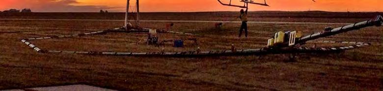
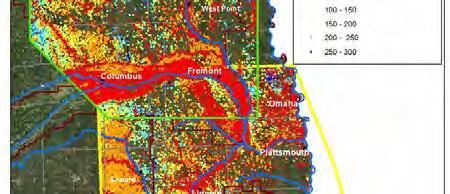
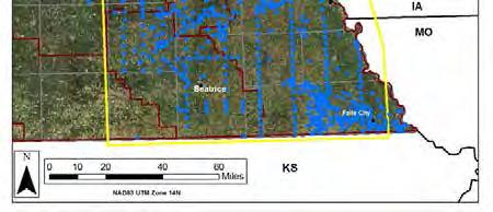
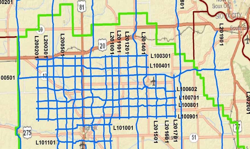
6 RECON FLIGHTS AEM survey AEM data processing incorporates existing data along flight lines Test holes logged by state geologists since 1940 Deep oil and gas well cores Study sites local studies and geologic reports Registered well logs Legend ENWRA Oct 2014 Flight Lines LENRD Grid Fall 2014 Planned Spring 2015 Flights Rivers ENWRA NRDs Existing ENWRA Pilot and Partner Studies Lewis & Clark Lower Elkhorn Lower Platte North Lower Platte South Nemaha Papio-Missouri River


7


8 E. AUKEN, U. OF AARHUS, DENMARK


9 FLIGHT LINE PLANNING Lines Planned along CSD Cross Sections Pipeline data were acquired from Platts ( CSD/ENWRA assisted in acquiring data on public power systems Auburn Board of Public Works, Burt County Power District, Butler County Power District, Cedar-Knox Power District, City of Fremont, Cornhusker Public Power District, Cuming County Power District, Elkhorn Rural Public Power District, Lincoln Electric Systems, Loup Power District, Nebraska Public Power District, Nemaha-Marshall Electric Cooperative, Norris Public Power District, North Central Public Power District, Northeast Nebraska Public Power District, Omaha Public Power District, Polk County Rural Public Power District, Seward County Public Power District, Stanton County Public Power District Flight lines were adjusted to optimize data collection


10 AEM EASTERN NEBRASKA , ,430 line-km 50 km 2,532 line-km 1,100 line-km 50 km October th, days of data collection 1 weather day (wind Oct 17) April th, days of data collection 2 weather day (rain April 18-19)


11 IN FIELD QA/QC AND INVERSION Within 24 hours we invert SkyTEM 508 system-first time gate 12 μsec 3.0 μsec wide and last time gate of 10.0 msec Aarhus Workbench SCI was used with 30 layer smooth inversion. First layer 5 m.


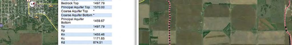
12 BACKGROUND BOREHOLE DATA


13 CSD HISTORICAL CROSS SECTIONS

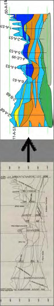
14 CSD CROSS SECTIONS
15 RESISTIVITY VERSUS LITHOLOGY AND AQUIFER MATERIALS Non Aquifer Marginal Aquifer Principal Aquifer Coarse Aquifer 39 CSD boreholes with lithology and resistivity geophysical logs ~209,000 individual measurements


16 LITHOLOGY VERSUS AQUIFER MATERIAL Non Aquifer Marginal Aquifer


17 LITHOLOGY VERSUS AQUIFER MATERIAL 21 to 50 Ohm-m Principal Aquifer Coarse Aquifer


18 CSD 5 GT METERS OFF LINE


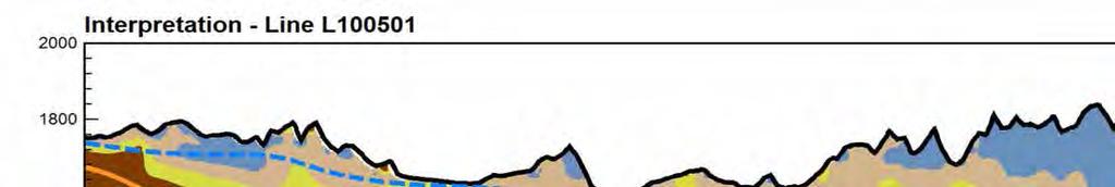
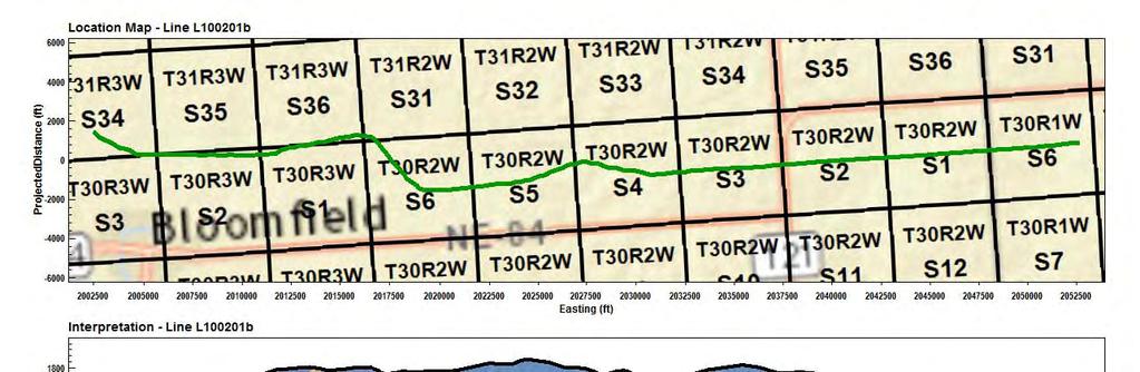
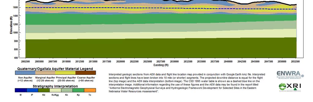
19 EXAMPLE CROSS SECTION


20 300 m 20 km

21 STRUCTURE IN THE PALEOZOIC 400 m 15 km

22 WATER QUALITY CHANGES


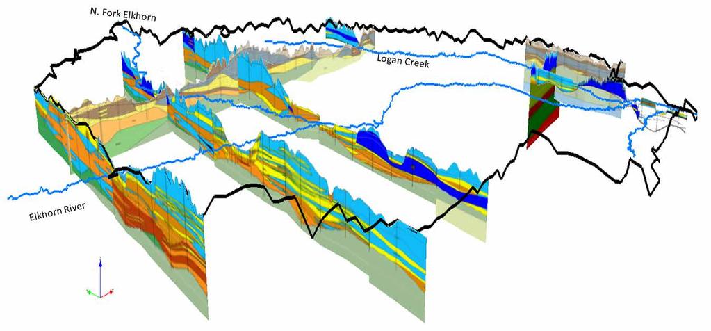
23 3D VIEW OF THE RESITIVITY OF ENWRA
24 300 m 20 km


25
26 AEM VERSUS CSD CROSS SECTION 111 km (69 mile) cross section with 27 test holes totaling 2,057 m(average depth of 76 m(250 ft)) $160,000 AEM cost (Average depth 304 m (1,000 ft)) $44,464 28% of the cost of drilling


27 3D OF THE 2014 AEM IN LENRD North


28 3D OF THE 2014 AEM IN LENRD North


29 3D OF THE 2014 AEM IN LENRD North

30 3D OF THE 2014 AEM IN LENRD North

31 3D OF THE 2014 AEM IN LENRD North


32 GOOGLE EARTH FILES
33


34
35 SURVEY CONCLUSIONS Aquifer resources vary considerably within the Quaternary and Tertiary system. The aquifer material is thicker in the western part of the ENWRA. The Quaternary and Tertiary material act as the principal aquifer in the west. Non-aquifer (aquitard) materials are abundant in the central and eastern portions of the survey area, with till and loess sequences exceeding 60 m. The full sequence of Cretaceous strata present in eastern Nebraska was detected by the AEM system. The full thickness of the Dakota (Kd) is revealed in the AEM survey. The AEM indicated potential areas of development. The structure in the Paleozoic was mappable in southeastern NE The line spacing at 3 miles grids can be used to delineate groundwater management areas. The reconnaissance line spacing for the ENWRA flights shows areas of interest for future work.


")


36 ACKNOWLEDGMENTS Susan Olafsen Lackey- Nebraska Conservation Survey Division (CSD), University of Nebraska Lincoln, School of Natural Sciences Rick Wozniak and Curt Becker Lower Elkhorn Natural Resources District (LENRD) Alan Stack, Pilot Native American Helicopters Jason Marcil, SkyTEM, Project Manager Devbrio Géophysique Inc. B.J. Crocker, Owner - Native American Helicopters Flemming Effersø, CEO SkyTEM Bill Brown, North American Sales SkyTEM Andrea Viezzoli, Aarhus Geophysics
37 CONTACTS Jared D. Abraham, MSc. Senior Research Geophysicist Golden, CO (303) Kathleen Cameron, P.G. ENWRA Project Coordinator Lincoln, NE (402)
Airborne Geophysics to Map Groundwater. Bill Brown
 Airborne Geophysics to Map Groundwater Bill Brown bb@skytem.com A 6 borehole represents 1 millionth of an acre Aquifer Materials An aquifer is an underground layer of water bearing permeable rock, rock
AIRBORNE ELECTROMAGNETIC SURVEYS FOR 3D GEOLOGICAL MAPPING
 AIRBORNE ELECTROMAGNETIC SURVEYS FOR 3D GEOLOGICAL MAPPING Jared D. Abraham 1 and James C. Cannia 2 1 United States Geological Survey, Crustal Geophysics and Geochemistry Science Center, United States
JAMES C. CANNIA, P.G.
 JAMES C. CANNIA, P.G. EXPERIENCE AQUA GEO Frameworks, LLC Principal and Senior Geologist July 2015 Has 35 years of geologic experience with 28 years of development, execution and management of hydrogeologic
Ground-Water Exploration in the Worthington Area of Nobles County: Summary of Seismic Data and Recent Test Drilling Results
 Ground-Water Exploration in the Worthington Area of Nobles County: Summary of Seismic Data and Recent Test Drilling Results Jim Berg and Todd Petersen Geophysicists, DNR Waters January 2000 Table of Contents
Summary. Introduction. Theory and/or Method
 Case studies from Fort Mc Murray, Horn River basin and Manitoba displaying advances in technology, new approach and updated interpretation of AEM data for unconventional hydrocarbons and groundwater mapping
Mini-SkyTEM: a new airborne transient EM system for near-surface aquifer mapping Cyril Schamper*, Esben Auken HydroGeophysics Group (Aarhus
 Mini-SkyTEM: a new airborne transient EM system for near-surface aquifer mapping Cyril Schamper*, Esben Auken HydroGeophysics Group (Aarhus University, Denmark) Outline I. The new Mini-SkyTEM system: AEM
AQUA GEO FRAMEWORKS QUALIFICATION AND EXPERIENCE. Current and Recent Work on Airborne Geophysical Projects
 AQUA GEO FRAMEWORKS Aqua Geo Frameworks is a Nebraska-based Limited Liability Company. The primary goal of Aqua Geo Frameworks LLC is to provide the very best scientific exploration, evaluation, and reporting
Minnesota Ground Water Association
 Fall 2006 Conference November 14, 2006 Ground Water Management The Minnesota Model - Data, Tools, Techniques, and Organization Jim Berg, Minnesota DNR Waters Mapping Hydrologic Systems Recent hydrologic/geologic
HyGEM - a new Strategic Research Council project for linking geophysical models to hydrological models
 HyGEM - a new Strategic Research Council project for linking geophysical models to hydrological models Anders Vest Christiansen, GEUS Esben Auken, Dept. of Geoscience, Aarhus University HyGEM Integrating
Harvey Thorleifson, Director, Minnesota Geological Survey. Status of geological mapping needed for groundwater protection in Minnesota
 Harvey Thorleifson, Director, Minnesota Geological Survey Status of geological mapping needed for groundwater protection in Minnesota Minnesota is located between the Dakotas and Wisconsin, north of Iowa,
Advanced processing and inversion of two AEM datasets for 3D geological modelling: the case study of Spiritwood Valley Aquifer
 Advanced processing and inversion of two AEM datasets for 3D geological modelling: the case study of Spiritwood Valley Aquifer Vincenzo Sapia, INGV, Rome, Italy Vincenzo.sapia@ingv.it Andrea Viezzoli,
Groundwater Resources of Missouri. Cynthia Brookshire, R. G.
 Groundwater Resources of Missouri Cynthia Brookshire, R. G. GROUNDWATER... Water beneath the Earth s surface within a zone of saturation AQUIFER... A geologic formation or group of formations that are
KANSAS GEOLOGICAL SURVEY Open File Report LAND SUBSIDENCE KIOWA COUNTY, KANSAS. May 2, 2007
 KANSAS GEOLOGICAL SURVEY Open File Report 2007-22 LAND SUBSIDENCE KIOWA COUNTY, KANSAS Prepared by Michael T. Dealy L.G., Manager, Wichita Operations SITE LOCATION The site was approximately four miles
A method for three-dimensional mapping, merging geologic interpretation, and GIS computation
 A method for three-dimensional mapping, merging geologic interpretation, and GIS computation Soller, David R., U.S. Geological Survey, 908 National Center, Reston, VA 20192 and Richard C. Berg, Illinois
MESOZOIC BASINS. North Carolina Geological Survey
 MESOZOIC BASINS North Carolina Geological Survey The 1823 organic act which created the North Carolina Geological Survey (NCGS) tasked us to examine, describe and map the geology, geologic hazards, and
Regional Groundwater Availability Study of the Edwards-Trinity Aquifer in parts of Pecos, Brewster, Jeff Davis and Reeves Counties, Texas
 Regional Groundwater Availability Study of the Edwards-Trinity Aquifer in parts of Pecos, Brewster, Jeff Davis and Reeves Counties, Texas Johnathan R. Bumgarner, P.G. Task Leads: Greg Stanton (Project
Rethink GroundWater Mapping and Management Strategies for Unconventional Uydrocarbons using Airborne EM
 Rethink GroundWater Mapping and Management Strategies for Unconventional Uydrocarbons using Airborne EM Andrea Viezzoli Aarhus Geophysics Aps, Andrea.viezzoli@aarhusgeo.com Summary The need to map, extract,
Tu Olym 01 Quantitative Depth to Bedrock Extraction from AEM Data
 Tu Olym 01 Quantitative Depth to Bedrock Extraction from AEM Data H. Anschütz (NGI), C. Christensen (Queen's University) & A.A. Pfaffhuber* (NGI) SUMMARY A new road segment is being planned northeast of
Tylr Naprstek Water Modeling Coordinator
 Tylr Naprstek Water Modeling Coordinator Focus development of Regional GW model for 2 basins: Loup, Elkhorn Niobrara R to Platte R Headwaters of Loup/Elkhorn to Columbus/Norfolk http://snr.unl.edu/data/geographygis/
Use of Non-Invasive Near-Surface Geophysics for Managing Brine Releases
 Use of Non-Invasive Near-Surface Geophysics for Managing Brine Releases Presented by: Brent W. Barker, Staff Geophysicist Remediation Technologies Symposium 2012 Imagine the result Co-Authors Boyce L.
Clay In Loess And Clay Content Of Loessial Soils In Southeastern Nebraska
 University of Nebraska - Lincoln DigitalCommons@University of Nebraska - Lincoln Transactions of the Nebraska Academy of Sciences and Affiliated Societies Nebraska Academy of Sciences 1982 Clay In Loess
Hydrogeology of East-Central Union County, Northeastern New Mexico
 Hydrogeology of East-Central Union County, Northeastern New Mexico Geoffrey Rawling April 2013 New Mexico Bureau of Geology & Mineral Resources 1 What are the important hydrogeologic issues in Union County?
Mapping the fresh-saltwater interface in the coastal zone using high-resolution airborne electromagnetics
 Mapping the fresh-saltwater interface in the coastal zone using high-resolution airborne electromagnetics Jesper B. Pedersen 1*, Frans W. Schaars 2, Anders V. Christiansen 1, Nikolaj Foged 1, Cyril Schamper
CREDENTIALS. HERBERT E. JOHNSTON 185 Manville Hill Rd, Unit 203 Cumberland, Rhode Island (401)
") CREDENTIALS HERBERT E. JOHNSTON 185 Manville Hill Rd, Unit 203 Cumberland, Rhode Island 02864-3617 (401) 658 4747 e-mail: hjohns1931@aol.com OCCUPATION: Hydrogeologist POSITIONS: o Groundwater consultant
CREDENTIALS HERBERT E. JOHNSTON 185 Manville Hill Rd, Unit 203 Cumberland, Rhode Island 02864-3617 (401) 658 4747 e-mail: hjohns1931@aol.com OCCUPATION: Hydrogeologist POSITIONS: o Groundwater consultant
Seismic Reflection Imaging across the Johnson Ranch, Valley County, Idaho
 Seismic Reflection Imaging across the Johnson Ranch, Valley County, Idaho Report Prepared for the Skyline Corporation Lee M. Liberty Center for Geophysical Investigation of the Shallow Subsurface (CGISS)
Description DESCRIPTION
 DESCRIPTION The location of the Upper James Watershed is located in northeastern South Dakota as well as southeastern North Dakota. It includes the following counties located in North Dakota Barnes, Dickey,
Geophysical Exploration in Water Resources Assessment. John Mundell, P.E., L.P.G., P.G. Ryan Brumbaugh, L.P.G. Mundell & Associates, Inc.
 Geophysical Exploration in Water Resources Assessment John Mundell, P.E., L.P.G., P.G. Ryan Brumbaugh, L.P.G. Mundell & Associates, Inc. Presentation Objective Introduce the use of geophysical survey methods
MEMORANDUM. Jerry Conrow, Ojai Basin Groundwater Management Agency
 MEMORANDUM TO: FROM: Jerry Conrow, Ojai Basin Groundwater Management Agency Gregory Schnaar, PhD, Stephen J. Cullen, PhD, PG, DATE: August 6, 2014, 2014 SUBJECT: Ojai Basin Groundwater Model - Extended
J.H. Campbell Generating Facility Pond A - Location Restriction Certification Report
 J.H. Campbell Generating Facility Pond A - Location Restriction Certification Report Pursuant to: 40 CFR 257.60 40 CFR 257.61 40 CFR 257.62 40 CFR 257.63 40 CFR 257.64 Submitted to: Consumers Energy Company
Istituto Nazionale di Geofisica e Vulcanologia, Rome,Italy 2. Geological Survey of Canada, Ottawa, Canada 3. Aarhus Geophysics Aps, Aarhus, Denmark
 INCORPORATING A-PRIORI INFORMATION INTO AEM INVERSION FOR GEOLOGICAL AND HYDROGEOLOGICAL MAPPING OF THE SPIRITWOOD VALLEY AQUIFER, MANITOBA, CANADA V. Sapia 1, G. Oldenborger 2 and A. Viezzoli 3 1 Istituto
R ENW Services - Geophysics & GIS
 Yankton Block 1 Vermillion Block 2 N 2 0 1 Block 3 Elk Point 2 3 4 5 6 MILES Block 4 R20-2002-01 0 1 2 3 4 5 6 7 8 9 10 KILOMETERS Block 5 Figure courtesy of ENW Services - Geophysics & GIS Block 6 Test
Combining airborne electromagnetics with geotechnical data for automated depth to bedrock tracking
 Combining airborne electromagnetics with geotechnical data for automated depth to bedrock tracking Craig W Christensen a,b,1, Andreas A Pfaffhuber a, Helgard Anschütz a and Tone F Smaavik a a Norwegian
Evaluation of Subsurface Formation of Pabna District, Bangladesh
 IOSR Journal of Applied Geology and Geophysics (IOSR-JAGG) e-issn: 2321 0990, p-issn: 2321 0982.Volume 1, Issue 4 (Sep. Oct. 2013), PP 30-36 Evaluation of Subsurface Formation of Pabna District, Bangladesh
Applied Geophysics for Environmental Site Characterization and Remediation
 Applied Geophysics for Environmental Site Characterization and Remediation MSECA Webinar September 24, 2015 John Mundell, P.E., L.P.G. Ryan Brumbaugh, L.P.G. MUNDELL & ASSOCIATES, INC. Webinar Objective
A surficial. P^HiHI waste disposal site, Bureau County, Illinois. east of the Sheffield low-level radioactive. electrical resistivity survey
 ISGS CONTRACT/GRANT REPORT 1981-6 WATER RESOURCES DIVISION/USGS P^HiHI 100240 557.09773 IL6cr 1981-6 A surficial electrical resistivity survey east of the Sheffield low-level radioactive waste disposal
Iterative modelling of AEM data based on a priori information from seismic and borehole data
 Near Surface Geophysics, 2014, 12, xxx-xxx doi:10.3997/1873-0604.2014024 Iterative modelling of AEM data based on a priori information from seismic and borehole data Anne-Sophie Høyer 1,2, Flemming Jørgensen
INTEGRATION OF BOREHOLE INFORMATION AND RESISTIVITY DATA FOR AQUIFER VULNERABILITY
 INTEGRATION OF BOREHOLE INFORMATION AND RESISTIVITY DATA FOR AQUIFER VULNERABILITY ANDERS V. CHRISTIANSEN 1, ESBEN AUKEN 1 AND KURT SØRENSEN 1 1 HydroGeophysics Group, Aarhus University, Finlandsgade 8,
Azimuthal Resistivity to Characterize Fractures in a Glacial Till. Mark Boris, University of Saskatchewan Jim Merriam, University of Saskatchewan
 Azimuthal Resistivity to Characterize Fractures in a Glacial Till Mark Boris, University of Saskatchewan Jim Merriam, University of Saskatchewan Abstract Azimuthal resistivity was used to characterize
The Groundwater Atlas of Lancaster County, Nebraska
 The Groundwater Atlas of Lancaster County, Nebraska Dana P. Divine Cartography by Leslie M. Howard Edited by R.F. Diffendal, Jr. Conservation and Survey Division School of Natural Resources Institute of
The Geology and Hydrogeology of the Spyhill Area
 The Geology and Hydrogeology of the Spyhill Area Clare North (WorleyParsons Komex) and Martin Ortiz (The City of Calgary) 2-Jul-08 Outline Background Site Location Existing Information New Work Geology
Overview of Selected Shale Plays in New Mexico*
 Overview of Selected Shale Plays in New Mexico* Ron Broadhead 1 Search and Discovery Article #10627 (2014)** Posted August 18, 2014 *Adapted from presentation at RMAG luncheon meeting, Denver, Colorado,
Last Updated HYDROLOGIC ATLAS OF THE BLACK HILLS, PENNINGTON COUNTY, SOUTH DAKOTA
 Last Updated 10-29-2015 HYDROLOGIC ATLAS OF THE BLACK HILLS, PENNINGTON COUNTY, SOUTH DAKOTA INTRODUCTION The following is a brief outline of ground water characteristics in Pennington County, South Dakota.
BUFFALO RIVER COALITION PO Box 101, Jasper, AR (870)
") BUFFALO RIVER COALITION PO Box 101, Jasper, AR 72641 (870) 446-5783 buffalowatershed@gmail.com Presentation before Arkansas Pollution Control and Ecology Commission, April 29, 2016 by Richard Mays on behalf
BUFFALO RIVER COALITION PO Box 101, Jasper, AR 72641 (870) 446-5783 buffalowatershed@gmail.com Presentation before Arkansas Pollution Control and Ecology Commission, April 29, 2016 by Richard Mays on behalf
NEW PRODUCTS AND ADVANCEMENTS IN 3-D MODELLING PROTOCOLS BASED ON STUDIES IN THICK DRIFT AREAS IN ONTARIO, CANADA
 NEW PRODUCTS AND ADVANCEMENTS IN 3-D MODELLING PROTOCOLS BASED ON STUDIES IN THICK DRIFT AREAS IN ONTARIO, CANADA Abigail K. Burt and Andrew F. Bajc Ontario Geological Survey, 933 Ramsey Lake Road, Sudbury,
Training the Next Generation of Geoscientists to Solve Realworld Environmental Problems using Advanced Techniques: Year Two Report
 Illinois State Geological Survey 615 E. Peabody Dr. Champaign, IL 61820 Training the Next Generation of Geoscientists to Solve Realworld Environmental Problems using Advanced Techniques: Year Two Report
AWRA PMAS Engineers Club of Philadelphia. A Geologic Perspective on Stormwater
 AWRA PMAS Engineers Club of Philadelphia A Geologic Perspective on Stormwater Toby J. Kessler, P.G. Hydrogeologist Trevor G. Woodward, P.G. Engineering Geologist September 10, 2014 Gilmore & Associates,
RESISTIVITY IMAGING IN EASTERN NEVADA USING THE AUDIOMAGNETOTELLURIC METHOD FOR HYDROGEOLOGIC FRAMEWORK STUDIES. Abstract.
 RESISTIVITY IMAGING IN EASTERN NEVADA USING THE AUDIOMAGNETOTELLURIC METHOD FOR HYDROGEOLOGIC FRAMEWORK STUDIES Darcy K. McPhee, U.S. Geological Survey, Menlo Park, CA Louise Pellerin, Green Engineering,
2017 Fowler Domain & Western Gawler Craton SkyTEM 312 AEM Survey, South Australia
 2017 Fowler Domain & Western Gawler Craton SkyTEM 312 AEM Survey, South Australia Geoscience Australia & the Geological Survey of South Australia D.J McInnes Geoscience Australia ecat ID 121550 Department
Cuyama Basin North Fork Vineyard
 Cuyama Basin North Fork Vineyard Company Background plus Data Insights to Support GSP Development for the Cuyama Basin Presented by Grapevine Capital Partners and Cleath-Harris Geologists April 26th, 2018
THE 4Gs IN PRACTICE: INVESTIGATING HOW THE 4Gs ARE APPLIED IN THE OIL & GAS INDUSTRY
 THE 4Gs IN PRACTICE: INVESTIGATING HOW THE 4Gs ARE APPLIED IN THE OIL & GAS INDUSTRY Society for Underwater Technology, Evening Technical Meeting 14 AUGUST 2013 GEOPHYSICS & PORT DEVELOPMENTS EXPLORING
A Standardized Digital Well-Record Database for the Glaciated U.S.
 A Standardized Digital Well-Record Database for the Glaciated U.S. Randy Bayless and Les Arihood U.S. Geological Survey, Indiana Water Science Center, Indianapolis, IN Howard Reeves U.S. Geological Survey,
Borah Peak Earthquake HAZUS Scenario Project Executive Summary Idaho Bureau of Homeland Security Idaho Geological Survey Western States Seismic
 Borah Peak Earthquake HAZUS Scenario Project Executive Summary Idaho Bureau of Homeland Security Idaho Geological Survey Western States Seismic Policy Council 12/30/2008 The HAZUS-MH analysis of the Borah
Preventing New Groundwater Pollution Problems from Old Oilfield Areas. Oklahoma Corporation Commission
 Preventing New Groundwater Pollution Problems from Old Oilfield Areas Patricia Billingsley, Brownfields Manager, Oklahoma Corporation Commission Last year I presented a case study about subdivision water
Georeferencing the Lackawanna Synclinorium using GIS
 Georeferencing the Lackawanna Synclinorium using GIS Conservation Services, LLC 2/20/2010 Contact: Philip Pass 570.510.1758 Rick Marquardt 570-335-7525 Managing Partners: Conservation Services LLC Author:
Michigan s Geology and Groundwater
 Michigan s Geology and Groundwater Ralph J. Haefner Deputy Director U.S. Geological Survey Michigan-Ohio Water Science Center Lansing, Michigan Outline About the USGS Geology 101 Michigan s geology Bedrock
Ground Water in the Piedmont and Blue Ridge
 engineering earth's development preserving earth's integrity Engineering Earth s Development Preserving Earth s Integrity Ground Water in the Piedmont and Blue Ridge Jim Renner Acknowledgements Contributors:
SEG Houston 2009 International Exposition and Annual Meeting
 The role of EM rock physics and seismic data in integrated 3D CSEM data analysis I. Brevik*, StatoilHydro, Pål T. Gabrielsen, Vestfonna and Jan Petter Morten, EMGS Summary An extensive 3D CSEM dataset
USE OF GEOPHYSICAL SURVEYS FOR FILL CHARACTERIZATION AND QUANTITY ESTIMATION AT BROWNFIELD SITES A CASE HISTORY. Abstract
 USE OF GEOPHYSICAL SURVEYS FOR FILL CHARACTERIZATION AND QUANTITY ESTIMATION AT BROWNFIELD SITES A CASE HISTORY John A. Mundell, Mundell & Associates, Inc., Indianapolis, IN Gregory B. Byer, Mundell &
Kiwanis International
 Page 1 of 11 Nebraska-Iowa 01 Division 1 K016 Cresco IA 22 21 23 24 24 24 9.09 +2 K00357 Mason City IA 23 23 23 23 22 22-4.35-1 K07050 Mason City-River City IA CSN 91 91 92 98 99 102 12.09 +11 K05788 Osage
BIOGEOCHEMISTRY Discovery Using Metal Concentrations in Plants
 1 BIOGEOCHEMISTRY Discovery Using Metal Concentrations in Plants Shea Clark Smith Minerals Exploration & Environmental Geochemistry P.O. Box 18325 Reno, Nevada 89511 Tel: 775-849-2235 Fax: 775-849-2335
FloaTEM mapping Sunds lake - HydroGeophysics Group - Aarhus University
 FloaTEM mapping Sunds lake - HydroGeophysics Group - Aarhus University FloaTEM Mapping Sunds lake Report number 06-11-2018, November 2018 TABLE OF CONTENTS 1. Introduction... 2 2. Data Collection... 4
RESISTIVITY IMAGING AND BOREHOLE INVESTIGATION OF THE BANTING AREA AQUIFER, SELANGOR, MALAYSIA. A.N. Ibrahim Z.Z.T. Harith M.N.M.
 JOURNAL OF ENVIRONMENTAL HYDROLOGY The Electronic Journal of the International Association for Environmental Hydrology On the World Wide Web at http://www.hydroweb.com VOLUME 11 2003 RESISTIVITY IMAGING
Case Study: University of Connecticut (UConn) Landfill
 Landfill") Case Study: University of Connecticut (UConn) Landfill Problem Statement:» Locate disposal trenches» Identify geologic features and distinguish them from leachate and locate preferential pathways in fractured
Case Study: University of Connecticut (UConn) Landfill Problem Statement:» Locate disposal trenches» Identify geologic features and distinguish them from leachate and locate preferential pathways in fractured
STRONG GOLD IN SOIL ANOMALY OUTLINED AT MARY HARRISON PROJECT HIGHLIGHTS
 National Stock Exchange of Australia Company Announcements Level 2, 117 Scott Street Newcastle NSW 2300 25 th January 2013 STRONG GOLD IN SOIL ANOMALY OUTLINED AT MARY HARRISON PROJECT HIGHLIGHTS 100m
GEOLOGICAL SURVEY OF DENMARK AND GREENLAND: EARLY SKETCHES FOR A DETAILED NATIONWIDE 3D GEOLOGICAL MODEL BASED ON GEOPHYSICAL DATA AND BOREHOLES
 GEOLOGICAL SURVEY OF DENMARK AND GREENLAND: EARLY SKETCHES FOR A DETAILED NATIONWIDE 3D GEOLOGICAL MODEL BASED ON GEOPHYSICAL DATA AND BOREHOLES Flemming Jørgensen, Richard Thomsen, Peter.B.E. Sandersen
Figure 1. Status of county-wide investigations in South Dakota.
 Harding Corson Campbell McPherson Marshall Roberts Perkins Walworth Edmunds Brown Day Dewey Grant Potter Faulk Butte Codington Ziebach Sully Spink Clark Hamlin Deuel Meade Hyde Hand Lawrence Haakon Stanley
3-D Geological Modelling at the OGS Products and Applications. I made a model!!! Now what?
 3-D Geological ling at the OGS Products and Applications or. I made a model!!! Now what? Abigail Burt Andy Bajc Riley Mulligan Desmond Rainsford John Dodge Meet the team Abigail Burt Andy Bajc Riley Mulligan
Structure contours on Bone Spring Formation (Lower Permian), Delaware Basin
, Delaware Basin") Structure contours on Bone Spring Formation (Lower Permian), Delaware Basin By Ronald F. Broadhead and Lewis Gillard New Mexico Bureau of Geology and Mineral Resources, a division of New Mexico Tech, Socorro
Structure contours on Bone Spring Formation (Lower Permian), Delaware Basin By Ronald F. Broadhead and Lewis Gillard New Mexico Bureau of Geology and Mineral Resources, a division of New Mexico Tech, Socorro
B. T. Brady, M. S. Bedinger, John Mikels, William H. Langer, and Deborah A. Mulvihill
 DEPARTMENT OF THE INTERIOR UNITED STATES GEOLOGICAL SURVEY TO ACCOMPANY WRI REPORT 83-4121-B MAP SHOWING GROUND-WATER LEVELS, SPRINGS. AND DEPTH TO GROUND WATER, BASIN AND RANGE PROVINCE, TEXAS by B. T.
Wisconsin s Hydrogeology: an overview
 2012 Soil and Water Conservation Society Conference Stevens Point, WI Feb 9, 2012 Wisconsin s Hydrogeology: an overview Ken Bradbury Wisconsin Geological and Natural History Survey University of Wisconsin-Extension
HYDROGEOLOGIC FRAMEWORK OF LONG ISLAND'S NORTH FORK, SUFFOLK COUNTY, NEW YORK
 HYDROGEOLOGIC FRAMEWORK OF LONG ISLAND'S NORTH FORK, SUFFOLK COUNTY, NEW YORK Christopher E. Schubert 1, Richard E. Bova 2, and Paul E. Misut 1 1 U.S. Geological Survey, 2045 Route 112, Building 4, Coram,
C13^COMMONWEALTH OF AUSTRALIA
 tal C13^COMMONWEALTH OF AUSTRALIA DEPARTMENT OF NATIONAL DEVELOPMENT BUREAU OF MINERAL RESOURCES, GEOLOGY AND GEOPHYSICS 44 1 NE/41 RECORD No. 1963/22 l^' it Ril R y#11, 1 zz^g M^ P3 C3 rn 00 GEOPHYSICAL
Delineating and Assessing Saline Ground Water Resources
 Delineating and Assessing Saline Ground Water Resources USGS Water Science Centers Arkansas Georgia OklahomA Sulfur water at Chickasaw National Recreation Area Sulphur, Oklahoma Background and Problem
Metallic Mineral Exploration in Minnesota: Typical Exploration Activities. Division of Lands and Minerals Minnesota Department of Natural Resources
 Metallic Mineral Exploration in Minnesota: Typical Exploration Activities Division of Lands and Minerals Minnesota Department of Natural Resources Metallic minerals can only be mined economically where
An Introduction to Field Explorations for Foundations
 An Introduction to Field Explorations for Foundations J. Paul Guyer, P.E., R.A. Paul Guyer is a registered mechanical engineer, civil engineer, fire protection engineer and architect with over 35 years
Chapter 8 Fetter, Applied Hydrology 4 th Edition, Geology of Groundwater Occurrence
 Chapter 8 Fetter, Applied Hydrology 4 th Edition, 2001 Geology of Groundwater Occurrence Figure 8.42. Alluvial Valleys ground-water region. Fetter, Applied Hydrology 4 th Edition, 2001 Fetter, Applied
- Cased-hole geophysical well logs - Airborne geophysics - Seismic data - LiDAR. GeoConvention 2015: New Horizons 1
 Thermal Effects and Quaternary Hydrogeology: Making Good Decisions in a Complex Geologic Setting Timothy Johnsen, Phd, Quaternary Specialist (tjohnsen@matrix-solutions.com) Alex Haluszka, MSc, P.Geol.,
fregonruleco. 1 U.S.A. 2
 3 5 fregonruleco. 1 U.S.A. 2 557.09773 IL6cr 1985-1 Qojl ^^\ ISGS CONTRACT/GRANT REPORT 1985-1 GEOPHYSICAL STUDIES AT THE SHEFFIELD LOW-LEVEL RADIOACTIVE WASTE DISPOSAL FACILITY TO EVALUATE POTENTIAL PATHWAYS
Jesse Crews, P.G. 1 Ahmad A. Behroozmand 2 Rosemary Knight 3. Senior Geophysicist, GEM Center*, Stanford University
 Jesse Crews, P.G. 1 Ahmad A. Behroozmand 2 Rosemary Knight 3 1 Senior Geophysicist, GEM Center*, Stanford University 2 Posdoctoral Researcher, Stanford University 3 Professor of Geophysics & Director of
Drilling program commences on Cloncurry and Mount Isa projects
 1P P May UASX/Media Announcement st 2009 Drilling program commences on Cloncurry and Mount Isa projects Key Points 1,700 metres reverse circulation drilling program over two prospects on untested geochemical,
Doug Kluck NOAA Kansas City, MO National Center for Environmental Information (NCEI) National Integrated Drought Information System (NIDIS)
 National Integrated Drought Information System (NIDIS)") National Integrated Drought Information System (NIDIS) for the Missouri River Basin Drought Early Warning Information System (DEWS) & Runoff Trends in the Missouri Basin & Latest Flood Outlook Doug Kluck
National Integrated Drought Information System (NIDIS) for the Missouri River Basin Drought Early Warning Information System (DEWS) & Runoff Trends in the Missouri Basin & Latest Flood Outlook Doug Kluck
Data Report for White Point Landslide Boring B-12 W.O. E Task Order Solicitation San Pedro District Los Angeles, California
 Data Report for White Point Landslide Boring B-12 W.O. E1907483 Task Order Solicitation 11-087 San Pedro District Los Angeles, California Submitted To: Mr. Christopher F. Johnson, P.E., G.E. City of Los
Pajaro Valley Hydrologic Model Base-Case Scenario
 Pajaro Valley Hydrologic Model Base-Case Scenario Board of Directors Meeting March 23, 2011 Presented by: Brian Lockwood, P.G., Hydrologist Acknowledgements, Base-Case The concept for the Base-Case scenario
Groundwater Vulnerability Mapping Eastern Newfoundland Executive Summary
 Groundwater Vulnerability Mapping Eastern Newfoundland Executive Summary 123102.00 Executive Summary March 2014 ISO 9001 Registered Company Prepared for: Water Resources Management Division Department
LIDAR: Statutory Compliance Benefits for Nebraska Natural Resources
 LIDAR: Statutory Compliance Benefits for Nebraska Natural Resources 2011 Nebraska GIS Symposium La Vista, NE April 21, 2011 Doug Hallum, P.G. Integrated Water Management Coordinator Nebraska Department
Soils, Hydrogeology, and Aquifer Properties. Philip B. Bedient 2006 Rice University
 Soils, Hydrogeology, and Aquifer Properties Philip B. Bedient 2006 Rice University Charbeneau, 2000. Basin Hydrologic Cycle Global Water Supply Distribution 3% of earth s water is fresh - 97% oceans 1%
Tu 23P1 06 Mapping Possible Flowpaths of Contaminants through Surface and Cross-borehole Spectral Timedomain Induced Polarization
 Tu 23P1 06 Mapping Possible Flowpaths of Contaminants through Surface and Cross-borehole Spectral Timedomain Induced Polarization T. Bording* (Aarhus University), G. Fiandaca (Aarhus University), P.K.
Geological Survey of Alabama Groundwater Assessment Program
 Geological Survey of Alabama Groundwater Assessment Program Hydrogeologic Characterization and Groundwater Source Development Assessment for Area 2, Southwestern Alabama Gheorghe M. Ponta, Marlon R. Cook,
Geophysical Surveys for Groundwater Modelling of Coastal Golf Courses
 1 Geophysical Surveys for Groundwater Modelling of Coastal Golf Courses C. RICHARD BATES and RUTH ROBINSON Sedimentary Systems Research Group, University of St. Andrews, St. Andrews, Scotland Abstract
IN SOUTH DAKOTA PAST, PRESENT, AND FUTURE. GERALD (MACK) McGILLIVRAY OCTOBER 8-9, 2008
 McGILLIVRAY OCTOBER 8-9, 2008") SHALLOW GAS EXPLORATION & PRODUCTION IN SOUTH DAKOTA PAST, PRESENT, AND FUTURE BY GERALD (MACK) McGILLIVRAY 2009 ROCKY MOUNTAIN UNCONVENTIONAL GAS CONFERENCE OCTOBER 8-9, 2008 HISTORY OF SHALLOW GAS IN
SHALLOW GAS EXPLORATION & PRODUCTION IN SOUTH DAKOTA PAST, PRESENT, AND FUTURE BY GERALD (MACK) McGILLIVRAY 2009 ROCKY MOUNTAIN UNCONVENTIONAL GAS CONFERENCE OCTOBER 8-9, 2008 HISTORY OF SHALLOW GAS IN
DESIGN-PHASE GEOLOGIC FRAMEWORK MODELING FOR LARGE CONSTRUCTION PROJECTS
 DESIGN-PHASE GEOLOGIC FRAMEWORK MODELING FOR LARGE CONSTRUCTION PROJECTS Christine Vilardi, P.G., C.G.W.P. (vilardcl@stvinc.com, STV Inc., New York, New York) and Todd Kincaid, Ph.D. (Hazlett-Kincaid,
HydroGeophysics Group. HydroGeophysics Group Institute for Geoscience, Aarhus University, Denmark
 HydroGeophysics Group HydroGeophysics Group Institute for Geoscience, Aarhus University, Denmark www.hgg.au.dk www.hygem.org People in HyGEM Esben Auken, PI Jesper Pedersen, HGG, administrative services
The Future is Under Cover
 The Future is Under Cover TSX.V: NGE OTCQX: NVDEF Disclaimer This Presentation contains certain "forward-looking statements" including, without limitation, expectations, beliefs, plans and objectives regarding
First Technical Report Geophysical experiments near Kajiado town
 First Technical Report Geophysical experiments near Kajiado town Synthesis Report of First case study within the ISGEAG VIA Water project By: Michel Groen *), Harry Rolf **), and Ammon Muiti ***) *) Acacia
APPENDIX F OKANAGAN VALLEY SEISMIC SURVEY
 APPENDIX F OKANAGAN VALLEY SEISMIC SURVEY F.1 INTRODUCTION F.2 DISCUSSION OF RESULTS OF 1970 TEST HOLE PROGRAM F.3 CONCLUSIONS 605 APPENDIX F.2 OKANAGAN VALLEY SEISMIC SURVEY By R.M. Lundberg, P. Eng F.1
KARST MAPPING WITH GEOPHYSICS AT MYSTERY CAVE STATE PARK, MINNESOTA
 KARST MAPPING WITH GEOPHYSICS AT MYSTERY CAVE STATE PARK, MINNESOTA By Todd A. Petersen and James A. Berg Geophysics Program Ground Water and Climatology Section DNR Waters June 2001 1.0 Summary A new
TOWARD A GOAL OF A SUPER THREE-DIMENSIONAL GEOLOGICAL MAP
 TOWARD A GOAL OF A SUPER THREE-DIMENSIONAL GEOLOGICAL MAP Richard C. Berg 1 and David R. Soller 2 1 Illinois State Geological Survey, Champaign, IL, USA, berg@isgs.uiuc.edu 2 U.S. Geological Survey, Reston,
IP 121 ILLINOIS PETROLEUJM Illinois Institute of Natdral Resources STATE GEOWGICA SURVEY DIVISION' Jack A. Simon. Chief
 IP 121 ILLINOIS PETROLEUJM 121 1981 Illinois Institute of Natdral Resources STATE GEOWGICA SURVEY DIVISION' Jack A. Simon. Chief Stevenson, D. L. (David L.) Geologic structure of the base of the New Albany
1978 MSc Geology, South Dakota School of Mines and Technology Introduction to Groundwater Vistas (Groundwater Modeling) Albuquerque, New Mexico
 Albuquerque, New Mexico") Clyde Yancey, BSc, MSc, PGeo Vice President of Exploration Education 1978 MSc Geology, South Dakota School of Mines and Technology 1975 BA Geology Trinity University 1999 Introduction to Groundwater Vistas
Clyde Yancey, BSc, MSc, PGeo Vice President of Exploration Education 1978 MSc Geology, South Dakota School of Mines and Technology 1975 BA Geology Trinity University 1999 Introduction to Groundwater Vistas
SASKATCHEWAN STRATIGRAPHY GLACIAL EXAMPLE BOULDERS IN GLACIAL DEPOSITS
 SASKATCHEWAN STRATIGRAPHY GLACIAL EXAMPLE BOULDERS IN GLACIAL DEPOSITS 51 SASKATCHEWAN STRATIGRAPHY GLACIAL SURFICIAL STRATIFIED DEPOSITS 52 SASKATCHEWAN STRATIGRAPHY GLACIAL EXAMPLE OF SEDIMENT DEPOSITION