Usage of any items from the University of Cumbria Repository Insight must conform to the following fair usage guidelines:
|
|
|
- Rosamond Banks
- 5 years ago
- Views:
Transcription
 Downloaded from: http://insight.cumbria.ac.")
1 van der Velden, Naomi, Brown, Lee, Carrivick, Jonathan and Dickson, Neil (2009) Spatial patterns in alpine flora communities in response to variation in glacial melt-water flow. In: British Ecological Society Annual Meeting 2009, 7-10 September 2009, University of Hertfordshire. (Unpublished) Downloaded from: Usage of any items from the University of Cumbria Repository Insight must conform to the following fair usage guidelines: Any item and its associated metadata held in the University of Cumbria Institutional Repository (unless stated otherwise on the metadata record) may be copied, displayed or performed, and stored in line with the JISC fair dealing guidelines (available at: for educational and not-for-profit activities provided that the authors, title and full bibliographic details of the item are cited clearly when any part of the work is referred to verbally or in the written form a hyperlink/url to the original Repository record of that item is included in any citations of the work the content is not changed in any way all files required for usage of the item are kept together with the main item file. You may not sell any part of an item refer to any part of an item without citation amend any item or contextualise it in a way that will impugn the author/creator/contributor s reputation remove or alter the copyright statement on an item. The full policy can be found at alternatively contact the University of Cumbria Repository Editor by ing insight@cumbria.ac.uk.
2

3 Spatial patterns in alpine flora communities in response to variation in glacial melt-water flow Naomi van der Velden, Lee Brown, Jonathan Carrivick, Neil Dickson BES 2009, Hertfordshire
4 Submitted abstract Alpine glacial retreat alters melt-water flow and impacts streamside flora. We assess spatial patterns in plant communities composition and diversity across a glacial braidplainsubject to extremes of inundation, desiccation, and sediment deposition. Patterns are related to channel stability and plant community age. Implications for this fragile ecosystem are considered.
5 Outline Introduction, issues and current research Aims of this project The study area Method (chronosequence and braidplain) Results (flora community) Conclusions and future
6 Introduction Mountain flora are highly sensitive to climate change (Thuiller et al PNAS 102(23) ) Glacial retreat and snow pack melt will change regimes of melt water runoff (Barnett et al., 2005 Nature ) Flora associated with melt water streams particularly vulnerable rapid changes in melt water flow (seasonal & diurnal) subject to extremes of inundation, sedimentation and desiccation Vegetation may stabilise river channels with impacts on flow rate, sediment levels, chemistry and invertebrate populations
 Water quality and flow Invertebrate communities")

7 Issues and research Impacts of melt-water flow on river system under investigation (Dickson, Brown, Carrivick) Water quality and flow Invertebrate communities Relationship between river channel stability and vegetation may be important River threatens plants Plants stabilize river 19 July 2008 Single channel 30 July 2008 Braided
8 Aims and objectives We aim to investigate (inter)relationship between vegetation and river channel stability Use vegetation community composition to examine long-term glacial melt-water channel disturbance
9 Study area Hohe Tauern National Park, Austria Ödenwinkelkees glacial valley metres elevation

10

11

12
13 Study area Chronosequence Glacial retreat documented in valley from 1850 to 1990 Opportunity to create chronosequence of vegetation succession and thus age vegetation communities Braidplain Braidplain located between 1850 and 1890 moraines Examine vegetation communities in relation to ageknown communities Examine spatial patterns in communities with relation to dynamism of river channels

14 Methods -chronosequence 1 -Chronosequence of flora near and between dated moraines Moraines deposited from glacier 18, 45, 55, 83, 118, and 158 years before this research


15 Methods -braidplain 100m 0 0 m 200 m 300 m 400 m 0


 %")

16 Sediment % cover by size class Vegetation height (x 5) % cover by species Methods
17 Analysis and Results 108 species (or groups) 65 quadrats in chronosequence (18 to 158 years) 92 quadrats across braidplain (83 vegetation) Multivariate ordination (Non-metric multidimensional scaling, NMS) to show species data along axes of greatest change

18 Results -community
19 Results -community nms1 nms2 nms3 vegetation height 0.727*** 0.240*** age 0.591*** * 0.551*** elevation *** 0.222*** 0.230*** slope aspect % fine sediment *** % sediment <1cm * *** *** % sediment 1-5cm *** * *** % sed 5-10cm *** *** *** % sed cm 0.181* % sed >150cm Pearson correlation * p 0.05 ** p 0.01 *** p 0.005
20 Results age of morraine

21 Results -community

22 Categorised NMS score (-1.5 to 1.5)


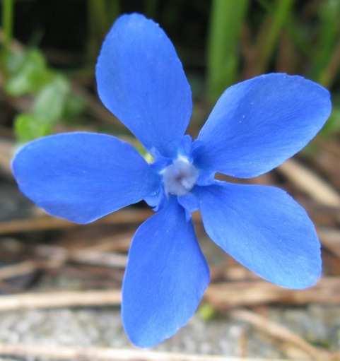
23 Silene vulgaris Linaria alpina Gentiana nivalis Aconitum napellus tauricum Saxifraga aizoides Saxifraga bryoides Oxyria digyna Campanula scheuchzeri Rhododendron ferrugineum Pioneer Established
24 Results Effective use of temporal data to explain spatial patterns Suggests similar change in community composition on the braidplain as along the chronosequence Surprisingly, the full range of communities found: Ages 18 to 158 The 158-year pattern of succession is represented in a much smaller space on the braidplain Works well in categories, looking at statistical models to explain data predicatively
25 Results -biodiversity NMS axis 1 less closely correlated with biodiversity that NMS axis 2 and NMS axis 3 NMS1 NMS2 NMS3 alpha diversity 0.181* 0.351*** 0.473*** Berger-Parker 1-d * *** *** Shannon-Weiner H 0.203* 0.317*** 0.440*** Simpson s 1-D 0.197* 0.284*** 0.381*** Pearson correlation * P <0.05 ** p< *** p< NMS axis 3 used for following visualisation

26 Species richness categories 1 = 1 to 4 2 = 5 to 8 3 = 9 to 12 4 = 13 to 16 5 = 17 to 20 6 = 21 to 24 7 = 25 to 30

27 Species richness categories 1 = 1 to 4 2 = 5 to 8 3 = 9 to 12 4 = 13 to 16 5 = 17 to 20 6 = 21 to 24 7 = 25 to 30
28 Conclusions and future Disturbance at a small scale can mimic patterns of a longer temporal scale and may be important in maintaining populations of early successional species As the glacier is exhausted, glacial melt-water flow will decrease: Less disturbance to vegetation on the braidplain Community successional development unrestricted Likely to see larger, late-successional species develop across the whole area Changes to river channel stability, water flow and chemistry Consequences for in-stream invertebrates, algaes, and other species

29 Thanks to: Dr Andy Evans & River Basins Research Cluster School of Geography, University of Leeds Alpine Rudolfshütte, Zell am See, Austria


30 Achillea moschata Adenostyles alliariae Campanula scheuchzeri Cerastium uniflorum Aconitum napellus tauricum Gentiana Rhododendron ferrugineum Doronicum poss clusii Oxyria digyna Trifolium pratense Saxifraga aizoides Saxifraga bryoides Phyteuma hemisphaericum Silene vulgaris Linaria alpina Homogyne alpina Silene acaulis Geum reptans
Downloaded from:
 Peck, Frank, Jackson, Keith and Mulvey, Gail (0) Regulation and growthoriented small businesses in North-West England. Journal of Small Business and Enterprise Development, (). pp. -. Downloaded from:
Spring break reading. Glacial formation. Surface processes: Glaciers and deserts. The Control of Nature
 suggested Spring break reading The Control of Nature by John McPhee Surface processes: Glaciers and deserts describes our efforts to control three natural hazards: 1. The Mississippi Floods 2. The Heimaey
Catalonia is a small region, managed by an autonomous government (depending from Spain), and placed in NE. Spain, next to Mediterranean sea.
, and placed in NE. Spain, next to Mediterranean sea.") Characterization of the river basin according to the WFD The Catalan Basins, a case of small Mediterranean water district Planning Department c/ Provença, 204-208 08036-Barcelona Introduction to Catalonia
Characterization of the river basin according to the WFD The Catalan Basins, a case of small Mediterranean water district Planning Department c/ Provença, 204-208 08036-Barcelona Introduction to Catalonia
River Response. Sediment Water Wood. Confinement. Bank material. Channel morphology. Valley slope. Riparian vegetation.
 River Response River Response Sediment Water Wood Confinement Valley slope Channel morphology Bank material Flow obstructions Riparian vegetation climate catchment vegetation hydrological regime channel
Fact sheet: Glacial rivers (all Europe)
") Fact sheet: Glacial rivers (all Europe) General description Valleyplanform Hydrology and The valley form varies from a gorge to a V-shaped valley and the single-thread channel is mainly characterized by
Fact sheet: Glacial rivers (all Europe) General description Valleyplanform Hydrology and The valley form varies from a gorge to a V-shaped valley and the single-thread channel is mainly characterized by
GEOG 1010 B. Come to the PASS workshop with your mock exam complete. During the workshop you can work with other students to review your work.
 It is most beneficial to you to write this mock midterm UNDER EXAM CONDITIONS. This means: Complete the midterm in 2 hours. Work on your own. Keep your notes and textbook closed. Attempt every question.
Statewide wetland geospatial inventory update
 Statewide wetland geospatial inventory update Factsheet 1: Outcomes from the statewide wetland geospatial inventory update 1 Introduction In 2011 the Victorian Department of Environment and Primary Industries
Impacts of snowpack accumulation and summer weather on alpine glacier hydrology
 Impacts of snowpack accumulation and summer weather on alpine glacier hydrology Caroline Aubry-Wake, Dhiraj Pradhananga, John W. Pomeroy GEWEX 8 th Open Science Meeting, Canmore AB, May 3-11 2018 Canadian
Use of benthic invertebrate biological indicators in evaluating sediment deposition impairment on the Middle Truckee River, California
 Use of benthic invertebrate biological indicators in evaluating sediment deposition impairment on the Middle Truckee River, California David B. Herbst Sierra Nevada Aquatic Research Laboratory University
Higher National Unit specification. General information for centres. Geology and Geomorphology. Unit title: Unit code: F3SL 34
 Higher National Unit specification General information for centres Unit title: Geology and Geomorphology Unit code: F3SL 34 Unit purpose: This Unit provides an introduction to geology and geomorphology.
Description This type exists as two distinct communities:
 Description This type exists as two distinct communities: A) Bluebunch wheatgrass -- big sage This community is dominated by bluebunch wheatgrass with a low (5-10%) cover of big sage brush. The big sage
Erosion and Deposition
 Erosion and Deposition Chapter Test A Multiple Choice Write the letter of the correct answer on the line at the left. 1. Water erosion begins when runoff from rainfall flows in a thin layer over the land
STUDY GUIDE FOR CONTENT MASTERY. Surface Water Movement
 Surface Water SECTION 9.1 Surface Water Movement In your textbook, read about surface water and the way in which it moves sediment. Complete each statement. 1. An excessive amount of water flowing downslope
How Do Human Impacts and Geomorphological Responses Vary with Spatial Scale in the Streams and Rivers of the Illinois Basin?
 How Do Human Impacts and Geomorphological Responses Vary with Spatial Scale in the Streams and Rivers of the Illinois Basin? Bruce Rhoads Department of Geography University of Illinois at Urbana-Champaign
Landscape. Review Note Cards
 Landscape Review Note Cards Last Ice Age Pleistocene Epoch that occurred about 22,000 Years ago Glacier A large, long lasting mass of ice which forms on land and moves downhill because of gravity. Continental
Earth s Major Terrerstrial Biomes. *Wetlands (found all over Earth)
") Biomes Biome: the major types of terrestrial ecosystems determined primarily by climate 2 main factors: Depends on ; proximity to ocean; and air and ocean circulation patterns Similar traits of plants
Biomes Biome: the major types of terrestrial ecosystems determined primarily by climate 2 main factors: Depends on ; proximity to ocean; and air and ocean circulation patterns Similar traits of plants
Class Notes: Surface Processes
 Name: Date: Period: Surface Processes The Physical Setting: Earth Science Class Notes: Surface Processes I. Weathering and Soils Weathering -! Sediments -! Weathering occurs when rocks are exposed to:
Science EOG Review: Landforms
 Mathematician Science EOG Review: Landforms Vocabulary Definition Term canyon deep, large, V- shaped valley formed by a river over millions of years of erosion; sometimes called gorges (example: Linville
The Cassiar Mountains
 The Cassiar Mountains Introduction Topography Dease Plateau Dease Lake, BC Stikine Ranges Eve Cone Mount Edziza Provincial Park Mount Ash, BC 2 125m Ketchika Ranges Muskwa- Ketchika Management Area Sifton
Climate Change. Unit 3
 Climate Change Unit 3 Aims Is global warming a recent short term phenomenon or should it be seen as part of long term climate change? What evidence is there of long-, medium-, and short- term climate change?
Cambridge International Examinations Cambridge International Advanced Subsidiary and Advanced Level
 Cambridge International Examinations Cambridge International Advanced Subsidiary and Advanced Level *5076877152* GEOGRAPHY 9696/11 Paper 1 Core Geography October/November 2015 No Additional Materials are
Which map shows the stream drainage pattern that most likely formed on the surface of this volcano? A) B)
 B)") 1. When snow cover on the land melts, the water will most likely become surface runoff if the land surface is A) frozen B) porous C) grass covered D) unconsolidated gravel Base your answers to questions
1. When snow cover on the land melts, the water will most likely become surface runoff if the land surface is A) frozen B) porous C) grass covered D) unconsolidated gravel Base your answers to questions
Hydrologic Analysis for Ecosystem Restoration
 Hydrologic Analysis for Ecosystem Restoration Davis, California Objectives: To provide participants with: 1) an understanding of the issues in restoration studies; 2) an overview of Corps policies and
Assessing Climate Change Vulnerability of Cultural Resources
 National Park Service U.S. Department of the Interior Klondike Gold Rush National Historical Park Assessing Climate Change Vulnerability of Cultural Resources Cultural Resources Caitlin Rankin, YLCC Climate
Chapter 3 Erosion and Deposition. The Big Question:
 Chapter 3 Erosion and Deposition The Big Question: 1 Design a way to represent and describe the 4 types of mass movement. You may use pictures, diagrams, list, web, chart, etc 2 Chapter 3: Erosion and
Chapter 2. Wearing Down Landforms: Rivers and Ice. Physical Weathering
 Chapter 2 Wearing Down Landforms: Rivers and Ice Physical Weathering Weathering vs. Erosion Weathering is the breakdown of rock and minerals. Erosion is a two fold process that starts with 1) breakdown
Erosion and Deposition
 Erosion and Deposition Erosion Sediment natural forces move rock/soil from one place to another. gravity, water, wind, glaciers, waves are causes material moved by erosion Deposition when erosion lays
Novel Snotel Data Uses: Detecting Change in Snowpack Development Controls, and Remote Basin Snow Depth Modeling
 Novel Snotel Data Uses: Detecting Change in Snowpack Development Controls, and Remote Basin Snow Depth Modeling OVERVIEW Mark Losleben and Tyler Erickson INSTAAR, University of Colorado Mountain Research
Spatiotemporal variations of alpine climate, snow cover and phenology
 Spatiotemporal variations of alpine climate, snow cover and phenology S. Asam, M. Callegari, M. Matiu, G. Fiore, L. De Gregorio, A. Jacob, A. Menzel, C. Notarnicola, M. Zebisch Asam et al., Spatiotemporal
Opportunities to Improve Ecological Functions of Floodplains and Reduce Flood Risk along Major Rivers in the Puget Sound Basin
 Opportunities to Improve Ecological Functions of Floodplains and Reduce Flood Risk along Major Rivers in the Puget Sound Basin Christopher Konrad, US Geological Survey Tim Beechie, NOAA Fisheries Managing
What is a Glacier? Types of Glaciers
 Alpine & Continental Glaciers Glacial Mass Balance Glacial Ice Formation Glacial Movement & Erosion Erosional and Depositional Landforms The Pleistocene Epoch Geomorphology of SW Manitoba Chapter 17 1
Water Information Portal User Guide. Updated July 2014
 Water Information Portal User Guide Updated July 2014 1. ENTER THE WATER INFORMATION PORTAL Launch the Water Information Portal in your internet browser via http://www.bcogc.ca/public-zone/water-information
Edinburgh Research Explorer
 Edinburgh Research Explorer GEOMORPHOLOGY Rivers split as mountains grow Citation for published version: Attal, M 2009, 'GEOMORPHOLOGY Rivers split as mountains grow' Nature Geoscience, vol. 2, no. 11,
Lower South Fork McKenzie River Floodplain Enhancement Project
 Lower South Fork McKenzie River Floodplain Enhancement Project McKenzie River Ranger District Willamette National Forest Project Location The project is located in the South Fork McKenzie River Watershed,
Chapter 9 Notes: Ice and Glaciers, Wind and Deserts
 Chapter 9 Notes: Ice and Glaciers, Wind and Deserts *Glaciers and Glacial Features glacier is a mass of ice that moves over land under its own weight through the action of gravity Glacier Formation must
Guided Notes Surface Processes. Erosion & Deposition By: Glaciers
 Guided Notes Surface Processes Erosion & Deposition By: Glaciers K. Coder 2015 26) How does moving ice erode and deposit sediments? Glaciers (Movement of Ice): a naturally formed mass of ice and snow that
Climate also has a large influence on how local ecosystems have evolved and how we interact with them.
 The Mississippi River in a Changing Climate By Paul Lehman, P.Eng., General Manager Mississippi Valley Conservation (This article originally appeared in the Mississippi Lakes Association s 212 Mississippi
Classification of Erosion Susceptibility
 GEO327G: GIS & GPS Applications in Earth Sciences Classification of Erosion Susceptibility Denali National Park, Alaska Zehao Xue 12 3 2015 2 TABLE OF CONTENTS 1 Abstract... 3 2 Introduction... 3 2.1 Universal
THE DIGITAL TERRAIN MAP LIBRARY: AN EXPLORATIONIST S RESOURCE
 THE DIGITAL TERRAIN MAP LIBRARY: AN EXPLORATIONIST S RESOURCE By I.C.L. Webster, P.J. Desjardins and W.E. Kilby KEYWORDS: digital terrain maps, digital terrain stability maps, surficial geology, GIS, raster
The SedAlp Project: WP6: INTERACTION WITH STRUCTURES
 The SedAlp Project: WP6: INTERACTION WITH STRUCTURES 6 th International conference Water in the Alps Herrenchiemsee, 12 th of October, 2016 Jošt Sodnik Contents Structure of SedAlp project (www.sedalp.eu)
Water, geology, climate & soils: Sierra Nevada, Merced River & Central Valley connections
 Water, geology, climate & soils: Sierra Nevada, Merced River & Central Valley connections Geography & geology Merced River basin Climate & hydrology Soils & soil formation Roger Bales UC Merced Water,
CHAPTER 1 INTRODUCTION
 CONTENTS Page No. CHAPTER 1 INTRODUCTION 1.1 LOCATION OF THE PROJECT 1-1 1.2 BACKGROUND 1-1 1.2.1 Previous Studies 1-2 1.2.2 NHPC Proposal 1-2 1.2.3 Work after Submission of PFR 1-3 1.3 PROJECT AREA 1-3
Conservation Planning evaluate land management alternatives to reduce soil erosion to acceptable levels. Resource Inventories estimate current and
 Conservation Planning evaluate land management alternatives to reduce soil erosion to acceptable levels. Resource Inventories estimate current and projected erosion levels and their impact on natural resource
2/23/2009. Visualizing Earth Science. Chapter Overview. Deserts and Drylands. Glaciers and Ice Sheets
 Visualizing Earth Science By Z. Merali and B. F. Skinner Chapter 6 Deserts, Glaciers and Ice Sheets Chapter Overview Deserts and Drylands Glaciers and Ice Sheets Deserts Geography Categorization of deserts
BEC Correlation BGxh2 01, 02, 05, 06. Site Characteristics
 Description This type is dominated by bluebunch wheatgrass, Sandberg s bluegrass, and sagebrush with low cover of mixed forbs and moderate cover of biological crusts. Production and total plant cover is
STREAM SYSTEMS and FLOODS
 STREAM SYSTEMS and FLOODS The Hydrologic Cycle Precipitation Evaporation Infiltration Runoff Transpiration Earth s Water and the Hydrologic Cycle The Hydrologic Cycle The Hydrologic Cycle Oceans not filling
Precipitation Evaporation Infiltration Earth s Water and the Hydrologic Cycle. Runoff Transpiration
 STREAM SYSTEMS and FLOODS The Hydrologic Cycle Precipitation Evaporation Infiltration Earth s Water and the Hydrologic Cycle Runoff Transpiration The Hydrologic Cycle The Hydrologic Cycle Oceans not filling
Alaska, USA. Sam Robbins
 Using ArcGIS to determine erosion susceptibility within Denali National Park, Alaska, USA Sam Robbins Introduction Denali National Park is six million acres of wild land with only one road and one road
1. Any process that causes rock to crack or break into pieces is called physical weathering. Initial product = final product
 Weathering 1. Any process that causes rock to crack or break into pieces is called physical weathering. Initial product = final product End Result of physical weathering is increased surface area. 2. Physical
The State of the cryosphere
 The State of the cryosphere Course outline Introduction The cryosphere; what is it? The Earth; a unique planet Cryospheric components Classifications Lecture outlines The State of the cryosphere The State
Chapter 2. Denudation: Rivers and Ice
 Chapter 2. Denudation: Rivers and Ice DENUDATION: process that lowers level of land - caused by rivers, glaciers, waves & wind - involves processes of WEATHERING & EROSION Weathering Def: breakdown of
RELATIVE IMPORTANCE OF GLACIER CONTRIBUTIONS TO STREAMFLOW IN A CHANGING CLIMATE
 Proceedings of the Second IASTED International Conference WATER RESOURCE MANAGEMENT August 20-22, 2007, Honolulu, Hawaii, USA ISGN Hardcopy: 978-0-88986-679-9 CD: 978-0-88-986-680-5 RELATIVE IMPORTANCE
EARTH S CHANGING SURFACE
 EARTH S CHANGING SURFACE Weathering Together, weathering and erosion work continuously to wear down the material on Earth s surface. weathering process that breaks down rock and other substances of Earth
Paper Reference. Paper Reference(s) 6461/01 Edexcel GCE Geography A Advanced Subsidiary Unit 1: Physical Environments
 6461/01 Edexcel GCE Geography A Advanced Subsidiary Unit 1: Physical Environments") Centre No. Candidate No. Paper Reference(s) 6461/01 Edexcel GCE Geography A Advanced Subsidiary Unit 1: Physical Environments Friday 25 May 2007 Afternoon Time: 1 hour 15 minutes Materials required for
Centre No. Candidate No. Paper Reference(s) 6461/01 Edexcel GCE Geography A Advanced Subsidiary Unit 1: Physical Environments Friday 25 May 2007 Afternoon Time: 1 hour 15 minutes Materials required for
Natural hazards in Glenorchy Summary Report May 2010
 Natural hazards in Glenorchy Summary Report May 2010 Contents Glenorchy s hazardscape Environment setting Flood hazard Earthquakes and seismic hazards Hazards Mass movement Summary Glossary Introduction
Sediment Deposition LET THE RIVER RUN T E A C H E R. Activity Overview. Activity at a Glance. Time Required. Level of Complexity.
 Activity at a Glance Grade: 6 9 Subject: Science Category: Physical Science, Earth Science Topic: Deposition, River Systems Time Required Two 45-minute periods Level of Complexity Medium Materials* TI-73
mountain rivers fixed channel boundaries (bedrock banks and bed) high transport capacity low storage input output
 high transport capacity low storage input output") mountain rivers fixed channel boundaries (bedrock banks and bed) high transport capacity low storage input output strong interaction between streams & hillslopes Sediment Budgets for Mountain Rivers Little
mountain rivers fixed channel boundaries (bedrock banks and bed) high transport capacity low storage input output strong interaction between streams & hillslopes Sediment Budgets for Mountain Rivers Little
3 Erosion and Deposition by Ice
 CHAPTER 12 3 Erosion and Deposition by Ice SECTION Agents of Erosion and Deposition BEFORE YOU READ After you read this section, you should be able to answer these questions: What are glaciers? How do
Geomorphology Of The Chilliwack River Watershed Landform Mapping At North Cascades National Park Service Complex, Washington By National Park Service
 Geomorphology Of The Chilliwack River Watershed Landform Mapping At North Cascades National Park Service Complex, Washington By National Park Service READ ONLINE Snowshed contributions to the Nooksack
Biodiversity indicators for UK habitats: a process for determining species-weightings. Ed Rowe
 Biodiversity indicators for UK habitats: a process for determining species-weightings Ed Rowe Outline Progress with UK model chain What can our models predict? Why weight species? Alternative species weightings
Usage of any items from the University of Cumbria s institutional repository Insight must conform to the following fair usage guidelines.
 Loynes, Christopher (2016) Leave more trace. In: Nature Connections 2nd Interdisciplinary Conference: Getting Connected to Nature, 15 June 2016, University of Derby, UK. (Unpublished) Downloaded from:
GEOL 1121 Earth Processes and Environments
 GEOL 1121 Earth Processes and Environments Wondwosen Seyoum Department of Geology University of Georgia e-mail: seyoum@uga.edu G/G Bldg., Rm. No. 122 Seyoum, 2015 Chapter 6 Streams and Flooding Seyoum,
Glaciers form wherever snow and ice can accumulate High latitudes High mountains at low latitudes Ice temperatures vary among glaciers Warm
 The Cryosphere Glaciers form wherever snow and ice can accumulate High latitudes High mountains at low latitudes Ice temperatures vary among glaciers Warm (temperate) glaciers: at pressure melting point,
,Baynes Lake. TO...?&.?...A 2...KO.?'!!&... Sr. *logical Engineer
 > i evernment OF BRITISH COLUMBIA a TO...?&.?...A 2....KO.?'!!&... Sr. *logical Engineer... Grou,,water. Section Hydrology Division Wat.er... In~.~s.tiga.ti.On.s..Branck.... 5 u BJECT...C;.roun.dw.ater...Snve
Biodiversity Classwork Classwork #1
 Biodiversity Classwork Classwork #1 1. What is biodiversity? 2. In the boxes below, create two ecosystems: one with low biodiversity and one with high biodiversity. Explain the difference. Biodiversity
Lowland Glaciation North Wales
 Lowland Glaciation North Wales Background Although there have been many glaciations and advances in ice, the most significant for this are was the Dimlington Stadial which was a period of glacial advance
Mountain Rivers. Gutta cavat lapidem. (Dripping water hollows out a stone) -Ovid, Epistulae Ex Ponto, Book 3, no. 10, 1. 5
 -Ovid, Epistulae Ex Ponto, Book 3, no. 10, 1. 5") Mountain Rivers Gutta cavat lapidem (Dripping water hollows out a stone) -Ovid, Epistulae Ex Ponto, Book 3, no. 10, 1. 5 Mountain Rivers Fixed channel boundaries (bedrock banks and bed) High transport
Mountain Rivers Gutta cavat lapidem (Dripping water hollows out a stone) -Ovid, Epistulae Ex Ponto, Book 3, no. 10, 1. 5 Mountain Rivers Fixed channel boundaries (bedrock banks and bed) High transport
MASS MOVEMENTS, WIND, AND GLACIERS
 Date Period Name MASS MOVEMENTS, WIND, AND GLACIERS SECTION.1 Mass Movements In your textbook, read about mass movements. Use each of the terms below just once to complete the passage. avalanche creep
Terrestrial Snow Cover: Properties, Trends, and Feedbacks. Chris Derksen Climate Research Division, ECCC
 Terrestrial Snow Cover: Properties, Trends, and Feedbacks Chris Derksen Climate Research Division, ECCC Outline Three Snow Lectures: 1. Why you should care about snow: Snow and the cryosphere Classes of
Cambridge International Examinations Cambridge International Advanced Subsidiary and Advanced Level
 Cambridge International Examinations Cambridge International Advanced Subsidiary and Advanced Level *8984944023* GEOGRAPHY 9696/12 Paper 1 Core Geography May/June 2015 No Additional Materials are required.
ANALYSIS OF GLACIER CHANGE IN THE SIERRA NEVADA PORTLAND STATE UNIVERSITY DEPARTMENT OF GEOLOGY BRADLEY BUSELLI
 ANALYSIS OF GLACIER CHANGE IN THE SIERRA NEVADA PORTLAND STATE UNIVERSITY DEPARTMENT OF GEOLOGY BRADLEY BUSELLI Study area: Sierra Nevada (Glaciers, 2015) Closer look (Glaciers, 2015) Primary goal: Research
COURSE SYLLABUS AND INSTRUCTOR PLAN
 WACO, TEXAS COURSE SYLLABUS AND INSTRUCTOR PLAN PRINCIPLES OF GEOGRAPHY GEOG-1300-01 Henry Apperson Course Description: Fall 2013 Introduction to the concepts which provide a foundation for continued study
Interactive comment on The impact of Saharan dust and black carbon on albedo and long-term glacier mass balance by J. Gabbi et al.
 The Cryosphere Discuss., 9, C553 C564, 2015 www.the-cryosphere-discuss.net/9/c553/2015/ Author(s) 2015. This work is distributed under the Creative Commons Attribute 3.0 License. The Cryosphere Discussions
The Hydrologic Cycle STREAM SYSTEMS. Earth s Water and the Hydrologic Cycle. The Hydrologic Cycle. Hydrologic Cycle
 STREAM SYSTEMS Earth Science: Chapter 5 Reading pages 114-124 The Hydrologic Cycle Oceans not filling up Evaporation = precipitation System is balanced Earth s Water and the Hydrologic Cycle Earth s Water
Best Management Practices for Coldwater Fisheries Enhancement and Restoration
 Best Management Practices for Coldwater Fisheries Enhancement and Restoration MACC Annual Environmental Conference 2017 March 3, 2017 Tim Dexter, MassDOT Highway Division 1 Leading the Nation in Transportation
Search for a location using the location search bar:
 Remap () is an online mapping platform for people with little technical background in remote sensing. We developed remap to enable you to quickly map and report the status of ecosystems, contributing to
Edexcel GCSE Geography A
 Edexcel GCSE Comparing the 2012 AQA GCSE specification with the new 2016 Edexcel specification This document is designed to help you compare the existing 2012 AQA GCSE specification (9030) with the new
KEY TERMS. Crevasse Glaciers Gravity Ground Water Iceberg
 10.3 SOURCES OF FRESH WATER P G. 3 7 6 OBJECTIVES Describe why run-off is important for rivers Describe how a small stream becomes a large river What is a drainage basin Describe the important and generation
Missouri Educator Gateway Assessments
 Missouri Educator Gateway Assessments FIELD 019: EARTH SCIENCE June 2014 Content Domain Range of Competencies Approximate Percentage of Test Score I. Science and Engineering Practices 0001 0003 18% II.
The Effect of Weather, Erosion, and Deposition in Texas Ecoregions
 The Effect of Weather, Erosion, and Deposition in Texas Ecoregions 7.8B: I can analyze the effects of weathering, erosion, and deposition on the environment in ecoregions of Texas Weathering The breakdown
GLOBAL WARMING: GLOBAL WARMING. landscape implications. Andrew Goudie St Cross College Oxford
 GLOBAL WARMING: GLOBAL WARMING landscape implications Andrew Goudie St Cross College Oxford THE PROCESS OF CHANGE HAS STARTED IPCC 2007 Increased Glacier retreat since the early 1990s Area of seasonally
Glacial Modification of Terrain
 Glacial Modification Part I Stupendous glaciers and crystal snowflakes -- every form of animate or inanimate existence leaves its impress upon the soul of man. 1 -Orison Swett Marden Glacial Modification
GCSE GEOGRAPHY SPECIFICATION A
 Please write clearly in block capitals. Centre number Candidate number Surname Forename(s) Candidate signature GCSE GEOGRAPHY SPECIFICATION A Higher Tier Unit 1 Physical Geography H Tuesday 24 May 2016
Lecture 10 Glaciers and glaciation
 Lecture 10 Glaciers and glaciation Outline Importance of ice to people! Basics of glaciers formation, classification, mechanisms of movement Glacial landscapes erosion and deposition by glaciers and the
Glacial processes and landforms NGEA01, 2014
 Glacial processes and landforms NGEA01, 2014 Cecilia Akselsson Department of Physical Geography and Ecosystem Science Lund University Geomorphological processes and landforms all over the world Periglacial
Dataset of Classification and Land Use of the Ecological Core Areas of China
 Journal of Global Change Data & Discovery. 2017, 1(4):426-430 DOI:10.3974/geodp.2017.04.07 www.geodoi.ac.cn 2017 GCdataPR Global Change Research Data Publishing & Repository Dataset of Classification and
Defining the Limit of Regulated Areas. C.1 Defining the River or Stream Flood Hazard 138. C.2 Defining the River or Stream Erosion Hazard 139
 C.1 Defining the River or Stream Flood Hazard 138 C.2 Defining the River or Stream Erosion Hazard 139 C.3 Defining Watercourses 141 C.4 Defining the Lake Ontario Shoreline Flood, Erosion and Dynamic Beach
A SURVEY OF HYDROCLIMATE, FLOODING, AND RUNOFF IN THE RED RIVER BASIN PRIOR TO 1870
 A SURVEY OF HYDROCLIMATE, FLOODING, AND RUNOFF IN THE RED RIVER BASIN PRIOR TO 1870 W. F. RANNIE (UNIVERSITY OF WINNIPEG) Prepared for the Geological Survey of Canada September, 1998 TABLE OF CONTENTS
Level 3 Geography, 2016
 91426 914260 3SUPERVISOR S USE ONLY Level 3 Geography, 2016 91426 Demonstrate understanding of how interacting natural processes shape a New Zealand geographic environment 9.30 a.m. Wednesday 16 November
Landscape evolution. An Anthropic landscape is the landscape modified by humans for their activities and life
 Landforms Landscape evolution A Natural landscape is the original landscape that exists before it is acted upon by human culture. An Anthropic landscape is the landscape modified by humans for their activities
Beaver Dam Influence on Wet Meadow Habitat
 Beaver Dam Influence on Wet Meadow Habitat HOPE FISHER WRITER S COMMENT: I ve always been fascinated by the natural world. This deep appreciation for nature and passion for conservation inspired me to
What are the different ways rocks can be weathered?
 Romano - 223 What are the different ways rocks can be weathered? Weathering - the breakdown of rocks and minerals at the Earth s surface 1. 2. PHYSICAL WEATHERING Rock is broken into smaller pieces with
Day 3 Weathering and Erosion.notebook. October 02, Section 7.2. Erosion and Deposition. Objectives
 Objectives Describe the relationship of gravity to all agents of erosion. Contrast the features left from different types of erosion. Analyze the impact of living and nonliving things on the processes
Glaciers. (Shaping Earth s Surface, Part 6) Science 330 Summer 2005
 Science 330 Summer 2005") Glaciers (Shaping Earth s Surface, Part 6) Science 330 Summer 2005 1 Glaciers Glaciers are parts of two basic cycles Hydrologic cycle Rock cycle Glacier a thick mass of ice that originates on land from
Glaciers (Shaping Earth s Surface, Part 6) Science 330 Summer 2005 1 Glaciers Glaciers are parts of two basic cycles Hydrologic cycle Rock cycle Glacier a thick mass of ice that originates on land from
Mass Movements, Wind, and Glaciers
 Mass Movements,, and Glaciers SECTION 8.1 Mass Movement at Earth s Surface In your textbook, read about mass movement. Use each of the terms below just once to complete the passage. avalanche creep landslide
Fundamentals of THE PHYSICAL ENVIRONMENT. David Briggs, Peter Smithson, Kenneth Addison and Ken Atkinson
 Fundamentals of THE PHYSICAL ENVIRONMENT Second Edition David Briggs, Peter Smithson, Kenneth Addison and Ken Atkinson LONDON AND NEW YORK Contents L,ISI Of colour piates List of black and white plates
Stream Geomorphology. Leslie A. Morrissey UVM July 25, 2012
 Stream Geomorphology Leslie A. Morrissey UVM July 25, 2012 What Functions do Healthy Streams Provide? Flood mitigation Water supply Water quality Sediment storage and transport Habitat Recreation Transportation
Weathering, Erosion and Deposition
 Weathering, Erosion and Deposition Shaping the Earth s Surface Weathering the process of breaking down rocks into smaller fragments Erosion the transport of rock fragments from one location to another
10/27/2014. Surface Processes. Surface Processes. Surface Processes. Surface Processes. Surface Processes
 Hewitt/Lyons/Suchocki/Yeh Conceptual Integrated Science Chapter 25 Surface or surficial processes originate at Earth's surface and reshape its contours. Surface processes include: Weathering Erosion Deposition
Day 1 of Global Warming. Copyright 2008 Pearson Education, Inc., publishing as Pearson Benjamin Cummings
 Day 1 of Global Warming Copyright 2008 Pearson Education, Inc., publishing as Pearson Benjamin Cummings The Atmosphere Atmosphere = the thin layer (1/100 th of Earth s diameter) of gases that surrounds