EBA Engineering ConsultCfnts Ltd.
|
|
|
- Joy Cross
- 5 years ago
- Views:
Transcription
1 I EBA Engineering ConsultCfnts Ltd. DETAILED TERRAIN STABILITY MAPPIN WAPCREEK RIVERSIDE FOREST PRODUCTS Lnv.DTE ARl\1STRONG DIVISION EBA Project No #255, 1715 Dickson Avenue, Kelowna, British Colqmbia V1Y9G6 Tel: (250) Fax: (250) Intemet: Icelowna@ebaJca - Web Site: http//
2 I I DETAILED TERRAIN STABILIfV MAPPING Wap Creek Prepared by: I EBA ENGINEERING CONSUL1ANTS LTD. Kelowna, B.C. Submitted to: RIVERSIDES FOREST PRODU01ifS LIMITED Armstrong Division i EBA Project No March, 2002 This project has been fund~d by FOREST RENEWAL BRITISH <COLUMBIA I
3 ! I I TABLE OF CONTENfI'S Page 1.0 INTRODUCTION METHODOLOGY...: Terrain Mapping Mapping Reliability Terrain Stability Interpretation Soil Erosion Potential Class PHySIOGRAPHy Topography and Bedrock Geology Landscape Evolution and Deposition of Surficial Materials SURFICIAL MATERIALS AND ASSOCIATED rlandforms Till (M)... J Glaciofluvial Materials (FG).....! ; 4.3 Colluvium (C) Fluvial Materials (F) Weathered Bedrock (D) Organic (0)... l ACTIVE GEOMORPHOLOGICAL PROCESSES.j Rapid Mass Movement (-R, -R") and Slow ass Movement (-F, -F") Debris Slides (-Rs, -R"s) and DebrisjFlows (-Rd, -R"d) Rockfall (-Rb, -R"b)...: Rockslump (-F"m)... ~ Gully Erosion (-V) Glacial Meltwater Channels (-E)... L Abundant Seepage (-L)... l Snow Avalanche (-A)... l TERRAIN STABILITY AND SOIL EROSION POTENTIAL - DISCUSSION AND MANAGEMENT IMPLICATIONS Terrain Stability Class and Soil Erosion Potential Class - Discussion Terrain Stability and Soil Erosion Potential - Management Implications RECOMMENDATIONS ACKNOWLEDGMENTS REFERENCES I 10.0 CLOSURE I
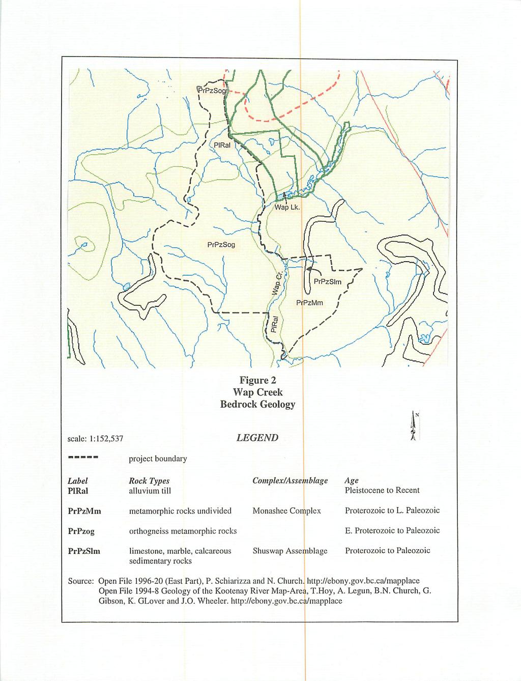
4 TABLES Page Table 2.1 Table 2.2 Terrain Stability Mapping Projects Complet~d Adjacent to the Wap Creek Study Area... J... 2 TRIM Sheets and Air Photographs Table 2.3 Field-Checking Statistics for the Total Area Including Alpine... 4 Table 2.4 Table 2.5 Table 2.6 Table 6.1 Field Checking Statistics for Polygons Mapped as Terrain Stability Classes IVTR, IV and V... ~... 4 I Guidelines for the Assessment of Detailed Tj Stability Classes... 6 Guidelines for the Assessment of Soil Erosir Potential Classes...,... 7 Implications of Detailed Terrain Stability CIftsses Table 6.2 Management Implications of Soil Erosion P&tential Classes FIGURES r... Figure 1... Traverse Map Figure Bedrock Geology Map APPENDICES Appendix A... r... Annotated Photographs! Appendix B... f... Legend I Appendix C... L, I I r i... Field Forms
5 March 21, INTRODUCTION! The objective of this project was to prepare detail~d (TSIL C) terrain stability mapping for Wap Creek, located within the operating area bf Riverside Forest Products Limited, Armstrong Division. This information is presentkd on 1 :20,000 scale terrain stability maps. EBA Engineering Consultants Ltd. (EBA~ completed the project for Riverside Forest Products Limited, with funding provided y Forest Renewal British Columbia (FRBC). The Wap Creek study area (7937 ha) is located b tween Three Valley Lake and Mabel Lake about 28 km east of Sicamous, BC. It streches from near Mount Griffm in the north to the mouth of Derry Creek in the south, i from the headwaters for Cavanaugh Creek in the west to a peak near Joss Mountain in the east (see Figure 1). Terrain mapping and interpretation of terrain sta~i1ity and soil erosion potential were carried out according to the provincial standards (Section 2.0). Terrain mapping was done on approximately l: 17,000 scale, colour rur photos by air photo interpretation followed by limited field checking. This report augments the information that is shown on the accompanying maps completed for this projept. I 2.0 METHODOLOGY 2.1 Terrain Mapping I The terrain mapping methods followed the Be pro~incia1 guidelines and standards set by the Resources Inventory Committee (RIC, 199p) and the Forest Practices Code Guidebook (FPC, 1999). Terrain classification followed the provincial system (Howes and Kenk, 1997). I I The Wap Creek study area boundary has been edg~-matched to existing adjacent terrain stability mapping project areas and the Mount Griffin Ecological Reserve and the Mount I Griffin Protected Area. Terrain Stability Mapping previously completed in nearby areas is listed in Table 2.1.
6
7
8

9
10
11

12
13

14
15
16
17
18
19
20
21
22
23
24
25
26
27

28

29

30

31

32

33
34

35
36
37
38
39
40

41

42
EBA Engineering Consultants Ltd.
 EBA Engineering Consultants Ltd. CHARCOAL CREEK DETAILED TERRAIN STABILITY MAPPING (TSIL C) SALMON ARM FOREST DISTRICT RIVERSIDE FOREST PRODllCTS LIMITED EBA Project No. 0801 99 81086 #255, 1715 Dickson
SCOTCH, KWIKOIT and CORNING CREEKS DETAILED and RECONNAISSANCE TERRAIN STABILITY MAPPING SALMON ARM FOREST DISTRICT. P. oject No.
 SCOTCH, KWIKOIT and CORNING CREEKS DETAILED and RECONNAISSANCE TERRAIN STABILITY MAPPING SALMON ARM FOREST DISTRICT P. oject No. 0808-98-89822 DETAILED and RECONNAISSANCE TERRAIN MAPPING with INTERPRETATIONS
E8A Engineering Consultants Ltd.
 E8A Engineering Consultants Ltd. SILVER CREEK FIRE i DETAILED TERRAIN STABILITY MAPPING SALMON ARM FOREST DISTRICT! Project No. 0808-98-89969 #255,1715 Dickson Ave., Kelowna, B.C. CANADA V1Y9G6 - Telephone
DETAILED TERRAIN MAPPING WITH INTERPRETATIONS FOR SLOPE STABILITY, EROSION POTENTIAL AND SEDIMENT TRANSFER. DILLARD CREEK FRBC Project # TO-96187
 ,, DETALED TERRAN MAPPNG WTH NTERPRETATONS FOR SLOPE STABLTY, EROSON POTENTAL AND SEDMENT TRANSFER DLLARD CREEK FRBC Project # TO-96187 Prepared by Blythe Killam, B.Sc., G..T. For Weyerhaeuser Canada Ltd.
MABEL LAKE RECONNAISSANCE TERRAIN STABILITY REPORT (T.S.I. LEVEL '0') to accompany
 to accompany") MABEL LAKE RECONNAISSANCE TERRAIN STABILITY REPORT (T.S.I. LEVEL '0') to accompany Terrain Stability Maps 82L.046; 047; 056;057;058;067; 068;077; 078; 088 Prepared for Riverside Forest Products Limited
MABEL LAKE RECONNAISSANCE TERRAIN STABILITY REPORT (T.S.I. LEVEL '0') to accompany Terrain Stability Maps 82L.046; 047; 056;057;058;067; 068;077; 078; 088 Prepared for Riverside Forest Products Limited
FL A ADAMS LAKE. KAMLOOPS AND CLEARWATER FOREST DISTRl 'TS TSILD RECONNAISSANCE SLOPE T ABILITY FINALREPOR. Submitted
 FL A18693 - ADAMS LAKE I KAMLOOPS AND CLEARWATER FOREST DISTRl 'TS TSILD RECONNAISSANCE SLOPE T ABILITY FINALREPOR Submitted to INTERNATIONAL FOREST PRODUCTS LTD. Adams Lake Divisibn Terratech Consulting
THE DIGITAL TERRAIN MAP LIBRARY: AN EXPLORATIONIST S RESOURCE
 THE DIGITAL TERRAIN MAP LIBRARY: AN EXPLORATIONIST S RESOURCE By I.C.L. Webster, P.J. Desjardins and W.E. Kilby KEYWORDS: digital terrain maps, digital terrain stability maps, surficial geology, GIS, raster
TEXAS CREEK AR. Prepared by. Jennifer Shypitka, B.Sc, GJ.T. For. B.C. Ministry of For sts Lillooet Forest Dist ict. January 1996
 1 1 TEXAS CREEK AR DETALED TERRAN M PPNG WTH EVALUATONS FOR SL PE STABLTY AND EROSON POTE TAL l Prepared by ennifer Shypitka, B.Sc, G.T. For B.C. Ministry of For sts Lillooet Forest Dist ict anuary 1996.M.
Detailed Terrain Stability Mapping In the Ellis Creek Community Watershed and the Steward Creek Watershed, Penticton Forest District, BC
 Detailed Terrain Stability Mapping In the Ellis Creek Community Watershed and the Steward Creek Watershed, Penticton Forest District, BC Prepared for: Ministry of Forests Penticton Forest District Small
RE: COMMUNITY WATERSHEDS TERRAIN STABILITY MAPPING FRBC PROJECT # T096198a(TOLKO), VERNON FOREST DISTRICT
, VERNON FOREST DISTRICT") Golder Associates Ltd. 100. 388 First Avenue Komloops, British Columbia, Canada V2C 6W3 Telephone 1250) 828 6116 Fax 1250) 828 1215 April 17, 1998 Our ref: 962-3150 Tolko Industries Ltd. c/o Kamloops Region
Golder Associates Ltd. 100. 388 First Avenue Komloops, British Columbia, Canada V2C 6W3 Telephone 1250) 828 6116 Fax 1250) 828 1215 April 17, 1998 Our ref: 962-3150 Tolko Industries Ltd. c/o Kamloops Region
SALMON RIVER TRI~UT ARIES
 SALMON RVER TR~UT ARES TERRAN STABLTY REPORT {T.5.1. LEVEL 'C'}; to accompany : Terrain and Terrain Stability Maps 82L.053, 82L.054, 82L.063, 82L.06~t and 82L.073 Prepared for Riverside Forest Products
MISSION CREEK WATERSHED (2002 Report Year 4)
") Stream Channel Monitoring Program for the MISSION CREEK WATERSHED (2002 Report Year 4) (Penticton Forest District) Prepared for RIVERSIDE FOREST PRODUCTS LTD. Prepared by DOBSON ENGINEERING LTD. #4, 1960
Stream Channel Monitoring Program for the MISSION CREEK WATERSHED (2002 Report Year 4) (Penticton Forest District) Prepared for RIVERSIDE FOREST PRODUCTS LTD. Prepared by DOBSON ENGINEERING LTD. #4, 1960
What is a Glacier? Types of Glaciers
 Alpine & Continental Glaciers Glacial Mass Balance Glacial Ice Formation Glacial Movement & Erosion Erosional and Depositional Landforms The Pleistocene Epoch Geomorphology of SW Manitoba Chapter 17 1
3.12 Geology and Topography Affected Environment
 3 Affected Environment and Environmental Consequences 3.12 Geology and Topography 3.12.1 Affected Environment 3.12.1.1 Earthquakes Sterling Highway MP 45 60 Project Draft SEIS The Kenai Peninsula is predisposed
ENGINEERING EVALUATION OF THE STANLEY MINE ADVENTURE PARK AREA CLEAR CREEK COUNTY, COLORADO. Prepared for:
 braun Braun Consulting Engineers ENGINEERING EVALUATION OF THE STANLEY MINE ADVENTURE PARK AREA CLEAR CREEK COUNTY, COLORADO Prepared for: STANLEY MINES ADENTURE PARK 3375 W. POWERS CIRCLE LITTLETON, COLORADO
Contrasting Behaviour of Two Recent, Large Landslides in Discontinuous Permafrost Little Salmon Lake, Yukon, Canada
 Contrasting Behaviour of Two Recent, Large Landslides in Discontinuous Permafrost Little Salmon Lake, Yukon, Canada Ryan R. Lyle BGC Engineering Inc. Kamloops, British Columbia D. Jean Hutchinson Queen
PHYSICAL GEOGRAPHY. By Brett Lucas
 PHYSICAL GEOGRAPHY By Brett Lucas GLACIAL PROCESSES Glacial Processes The Impact of Glaciers on the Landscape Glaciations Past and Present Types of Glaciers Glacier Formation and Movement The Effects of
Glacial Modification of Terrain
 Glacial Modification Part I Stupendous glaciers and crystal snowflakes -- every form of animate or inanimate existence leaves its impress upon the soul of man. 1 -Orison Swett Marden Glacial Modification
Mass Movements, Wind, and Glaciers
 Mass Movements,, and Glaciers SECTION 8.1 Mass Movement at Earth s Surface In your textbook, read about mass movement. Use each of the terms below just once to complete the passage. avalanche creep landslide
When Creek Meets Valley Wall: Prioritizing Erosion Mitigation alongside the Oshawa Landfill
 1 When Creek Meets Valley Wall: Prioritizing Erosion Mitigation alongside the Oshawa Landfill Robin McKillop 1, Dan McParland 1 & Cassie Scobie 2 TRIECA conference March 22-23, 2017 1 Palmer Environmental
SENSITIVITY ANALYSIS OF THE RAMMS AVALANCHE DYNAMICS MODEL IN A CANADIAN TRANSITIONAL SNOW CLIMATE
 SENSITIVITY ANALYSIS OF THE RAMMS AVALANCHE DYNAMICS MODEL IN A CANADIAN TRANSITIONAL SNOW CLIMATE Ryan Buhler 1 *, Chris Argue 1, Bruce Jamieson 2, and Alan Jones 1 1 Dynamic Avalanche Consulting Ltd.,
The subject paper is being submitted for approval for publication in the annual volume entitled Geological Survey Research.
 Water Resources Division 345 Middlefield Road Menlo Park, California January 12, 1965 Memorandum To: Mr. Frank E. Clark, Chief, General Hydrology Branch Thru: Area Hydrologist PCA From: Valmore C. LaMarche
MASS MOVEMENTS, WIND, AND GLACIERS
 Date Period Name MASS MOVEMENTS, WIND, AND GLACIERS SECTION.1 Mass Movements In your textbook, read about mass movements. Use each of the terms below just once to complete the passage. avalanche creep
PHYSICAL WORK REPORT. the BAY CLAIMS. Omineca Mining Division Smithers, British Columbia N.T.S. 93E 13E/W
 PHYSICAL WORK REPORT the BAY CLAIMS Omineca Mining Division Smithers, British Columbia a N.T.S. 93E 13E/W LATITUDE: 53 57 00 N I LONGITUDE: 127 45 OO W for Home Ventures Ltd. 1201-675 West Hastings Street
EBA Engineering Consultants Ltd. Creating and Delivering Better Solutions
 EBA Engineering Consultants Ltd. Creating and Delivering Better Solutions ENHANCING THE CAPABILITY OF ECOSYSTEM MAPPING TO SUPPORT ADAPTIVE FOREST MANAGEMENT Prepared by: EBA ENGINEERING CONSULTANTS LTD.
ENVIRONMENTAL GEOSCIENCE UNIFORM SYLLABUS
 ENVIRONMENTAL GEOSCIENCE UNIFORM SYLLABUS The Association of Professional Engineers and Geoscientists of the Province of British Columbia Note: 1. This Syllabus May Be Subject To Change 2. These Courses
June 9, R. D. Cook, P.Eng. Soils Engineer Special Services Western Region PUBLIC WORKS CANADA WESTERN REGION REPORT ON
 PUBLIC WORKS CANADA WESTERN REGION REPORT ON GEOTECHNICAL INVESTIGATION PROPOSED MARTIN RIVER BRIDGE MILE 306.7 MACKENZIE HIGHWAY Submitted by : R. D. Cook, P.Eng. Soils Engineer Special Services Western
About the present study
 About the present study This study presents results obtained under the project Models of contemporary Periglacial Morphogenesis a first stage of Bulgarian Periglacial Programme a programme for observation
MINISTRY OF FORESTS, LANDS AND NATURAL RESOURCE OPERATIONS, POST-WILDFIRE RISK ANALYSIS PRELIMINARY REPORT
 MINISTRY OF FORESTS, ANDS AND NATURA RESOURCE OPERATIONS, POST-WIDFIRE RISK ANAYSIS PREIMINARY REPORT NOTE: The results given on this form are preliminary in nature and are intended to be a warning of
TERRAIN STABILITY ASSESSMENT SOIL EROSION ASSESSMENT. Proposed Perry Ridge North (PN) Forest Roads: Mainline Extension; 11000; 11030; and 11040
 Forest Roads: Mainline Extension; 11000; 11030; and 11040") TERRAIN STABILITY ASSESSMENT SOIL EROSION ASSESSMENT Proposed Perry Ridge North (PN) Forest Roads: Mainline Extension; 11000; 11030; and 11040 Selkirk Forest District Prepared for: British Columbia Timber
TERRAIN STABILITY ASSESSMENT SOIL EROSION ASSESSMENT Proposed Perry Ridge North (PN) Forest Roads: Mainline Extension; 11000; 11030; and 11040 Selkirk Forest District Prepared for: British Columbia Timber
CHAPTER 28. PHYSIOGRAPHY Cook Inlet Drainages
 PEBBLE PROJECT ENVIRONMENTAL BASELINE DOCUMENT 2004 through 2008 CHAPTER 28. PHYSIOGRAPHY Cook Inlet Drainages PREPARED BY: Knight Piésold Ltd. PHYSIOGRAPHY COOK INLET DRAINAGES TABLE OF CONTENTS TABLE
Mark Hawley, Piteau Associates Engineering Ltd. John Cunning, Golder Associates Ltd.
 Introducing: GUIDELINES FOR MINE WASTE DUMP AND STOCKPILE DESIGN Editors: Mark Hawley, Piteau Associates Engineering Ltd. John Cunning, Golder Associates Ltd. 8 November 2017 Sponsorship 8 November 2017
Erosion and Deposition
 Erosion and Deposition Erosion Sediment natural forces move rock/soil from one place to another. gravity, water, wind, glaciers, waves are causes material moved by erosion Deposition when erosion lays
patersongroup Mineral Aggregate Assessment 3119 Carp Road Ottawa, Ontario Prepared For Mr. Greg LeBlanc March 7, 2014 Report: PH2223-REP.
 Geotechnical Engineering Environmental Engineering group Hydrogeology Geological Engineering Archaeological Studies Materials Testing 3119 Carp Road Prepared For Mr. Greg LeBlanc March 7, 2014 Paterson
,Baynes Lake. TO...?&.?...A 2...KO.?'!!&... Sr. *logical Engineer
 > i evernment OF BRITISH COLUMBIA a TO...?&.?...A 2....KO.?'!!&... Sr. *logical Engineer... Grou,,water. Section Hydrology Division Wat.er... In~.~s.tiga.ti.On.s..Branck.... 5 u BJECT...C;.roun.dw.ater...Snve
Lower Mainland Surficial Geology From Wisconsin Ice Age to Protocol 21
 Lower Mainland Surficial Geology From Wisconsin Ice Age to Protocol 21 BCEIA BEST Conference 2018 Whistler, BC Kalina Malowany and Virginie Brunetaud Presentation Outline 1. Surficial Geology it s more
Gully Assessment Procedure Guidebook
 of BRITISH COLUMBIA Gully Assessment Procedure Guidebook Fourth edition Version 4.1 February 2001 Ministry of Forests of BRITISH COLUMBIA Gully Assessment Procedure Guidebook Fourth edition Version 4.1
Internet Mapping Framework 1 (IMF) to Common Web Mapping (CWM) Legend Comparison
 to Common Web Mapping (CWM) Legend Comparison") Internet Mapping Framework 1 (IMF) to Common Web Mapping () Legend Comparison IMF Legend Legend Folders Titles (MTO) - Mineral, Placer, Coal Map Viewers.. 3 Coal Grid - Coal Map Viewer. 4 Tenure History
Internet Mapping Framework 1 (IMF) to Common Web Mapping () Legend Comparison IMF Legend Legend Folders Titles (MTO) - Mineral, Placer, Coal Map Viewers.. 3 Coal Grid - Coal Map Viewer. 4 Tenure History
GUIDELINES AND STANDARDS TO TERRAIN MAPPING IN British Columbia
 RESOURCES INVENTORY COMMITTEE APPROVED STANDARD GUIDELINES AND STANDARDS TO TERRAIN MAPPING IN British Columbia by Resources Inventory Committee Surficial Geology Task Group Earth Sciences Task Force British
3.12 Geology and Topography Affected Environment
 3 Affected Environment and Environmental Consequences 3.12 Geology and Topography 3.12.1 Affected Environment 3.12.1.1 Earthquakes Sterling Highway MP 45 60 Project Final EIS The Kenai Peninsula is predisposed
Geomorphology Of The Chilliwack River Watershed Landform Mapping At North Cascades National Park Service Complex, Washington By National Park Service
 Geomorphology Of The Chilliwack River Watershed Landform Mapping At North Cascades National Park Service Complex, Washington By National Park Service READ ONLINE Snowshed contributions to the Nooksack
Maggie Payne Jim Turenne
 Maggie Payne Jim Turenne USDA-NRCS 60 Quaker Lane, Suite 46 Warwick, RI. 02886 401-822-8832 maggie.payne@ri.usda.gov U.S. Department of Agriculture 1935: Soil Conservation Service (SCS) Natural Resources
Groundwater Investigation SOUTHGATE GRAVEL PIT Part of Lot 15, Concession 15 (formerly Township of Proton), Township of Southgate.
, Township of Southgate.") Groundwater Investigation SOUTHGATE GRAVEL PIT Part of Lot 15, Concession 15 (formerly Township of Proton), Township of Southgate County of Grey October, 2014 Prepared for: Drysdale Aggregate Consulting
Groundwater Investigation SOUTHGATE GRAVEL PIT Part of Lot 15, Concession 15 (formerly Township of Proton), Township of Southgate County of Grey October, 2014 Prepared for: Drysdale Aggregate Consulting
PALEOGEOGRAPHY of NYS. Definitions GEOLOGIC PROCESSES. Faulting. Folding 9/6/2012. TOPOGRAPHIC RELIEF MAP of NYS GRADATIONAL TECTONIC
 TOPOGRAPHIC RELIEF MAP of NYS PALEOGEOGRAPHY of NYS Prof. Anthony Grande AFG 2012 Definitions GEOLOGIC PROCESSES Geography: study of people living on the surface of the earth. Geology: the scientific study
Road and Terrain Attributes of Road Fill Landslides in the Kalum Forest District
 T E C H N I C A L R E P O R T 0 2 4 Road and Terrain Attributes of Road Fill Landslides in the Kalum Forest District 2005 Ministry of Forests and Range Forest Science Program Road and Terrain Attributes
Bell Ringer. Are soil and dirt the same material? In your explanation be sure to talk about plants.
 Bell Ringer Are soil and dirt the same material? In your explanation be sure to talk about plants. 5.3 Mass Movements Triggers of Mass Movements The transfer of rock and soil downslope due to gravity is
MANAGEMENT OF LARGE MUDSLIDES
 36 MANAGEMENT OF LARGE MUDSLIDES Three large and active mudslides Poche, 1860?, Super-Sauze, 1960?, La Valette, March 1982, 1 M m 3 900,000 m 3 4-5 M m 3 37 Three large and active mudslides Type of development:
THE ACTION OF GLACIERS
 Surface processes THE ACTION OF GLACIERS Glaciers are enormous masses of ice which are formed due to accumulation, compaction and re-crystallisation of the snow deposited in very cold regions (the majority
GEOLOGICAL MAPPING REPORT ON THE ASH MINERAL CLAIM OSOYOOS MINING DIVISION ASHNOLA RIVER MAP SHEET NTS M092,H019 MCBRIDE CREEK AREA, ASHNOLA RIVER,
 GEOLOGICAL MAPPING REPORT ON THE ASH MINERAL CLAIM OSOYOOS MINING DIVISION ASHNOLA RIVER MAP SHEET NTS M092,H019 LATITUDE 49 o O6, LONGITUDE 120 o 22 MCBRIDE CREEK AREA, ASHNOLA RIVER, KEREMEOS, B.C. CANADA
6.0 GEOHAZARD INVENTORY
 6.0 GEOHAZARD INVENTORY A geohazard (a subset of natural hazards) is an event caused by geological features and processes that present severe threats to humans, property and natural and built environments
The Cassiar Mountains
 The Cassiar Mountains Introduction Topography Dease Plateau Dease Lake, BC Stikine Ranges Eve Cone Mount Edziza Provincial Park Mount Ash, BC 2 125m Ketchika Ranges Muskwa- Ketchika Management Area Sifton
BCTS BC TIMBER SALES STRAIT OF GEORGIA BUSINESS AREA
 Terrain Stability Assessment Additional area added to Cutblock C34M McNab Creek PREPARED FOR: BCTS BC TIMBER SALES STRAIT OF GEORGIA BUSINESS AREA PREPARED BY: COAST OPERATIONS #213-1720 14TH AVE. CAMPBELL
Vermont Stream Geomorphic Assessment. Appendix E. River Corridor Delineation Process. VT Agency of Natural Resources. April, E0 - April, 2004
 Vermont Stream Geomorphic Assessment Appendix E River Corridor Delineation Process Vermont Agency of Natural Resources - E0 - River Corridor Delineation Process Purpose A stream and river corridor delineation
Lecture Outlines PowerPoint. Chapter 6 Earth Science 11e Tarbuck/Lutgens
 Lecture Outlines PowerPoint Chapter 6 Earth Science 11e Tarbuck/Lutgens 2006 Pearson Prentice Hall This work is protected by United States copyright laws and is provided solely for the use of instructors
Taseko Prosperity Gold-Copper Project. Appendix 3-6-Q
 Taseko Prosperity Gold-Copper Project Appendix 3-6-Q KNIGHT & PIESOLD LTD. AND TASEKO MINES LIMITED REPORT ON SEISMIC REFRACTION AND REFLECTION INVESTIGATION PROSPERITY PROJECT, FISH LAKE AREA WILLIAMS
1.0 INTRODUCTION 2.0 OBSERVATIONS EBA FILE: W nd Avenue Whitehorse, YT Y1A 1C2. Attention:
 August 5, 2013 City of Whitehorse 2121 2 nd Avenue Whitehorse, YT Y1A 1C2 ISSUED FOR USE EBA FILE: W14103182-01 Via Email: ben.campbell@whitehorse.ca Attention: Subject: Ben Campbell, Planner II Planning
PHASE 1 STUDIES UPDATE EROSION WORKING GROUP
 PHASE 1 STUDIES UPDATE EROSION WORKING GROUP Presented By MICHAEL WOLFF, PG Erosion Study Area Manager West Valley Demonstration Project Quarterly Public Meeting February 24, 2016 OUTLINE Study 1 Terrain
Mass Wasting: The Work of Gravity
 Chapter 15 Lecture Earth: An Introduction to Physical Geology Twelfth Edition Mass Wasting: The Work of Gravity Tarbuck and Lutgens Chapter 15 Mass Wasting The Importance of Mass Wasting Slopes are the
EXPLORATION and DEVELOPMENT REPORT. Conrad Creek. PLACER and MINERAL CLAIMS SOUTHEAST BRITISH COLUMBIA
 EXPLORATION and DEVELOPMENT REPORT on Conrad Creek PLACER and MINERAL CLAIMS in SOUTHEAST BRITISH COLUMBIA Ed Friesen, BSc.E.E., P. Eng 8 Lake Placid Rise SE Calgary, Alberta T2J 5B5 April 2009 1 P age
Landscapes Prone to Rockfall, Rockslides, Debris Avalanches, Flows, and Torrents
 1) Landform Regional landscape Landscapes are qualitative indicators of unstable terrain that may be obtained from air photos, topographic maps, and limited field reconnaissance. Landscapes Prone to Rockfall,
Fluvial Systems Lab Environmental Geology Lab Dr. Johnson
 Fluvial Systems Lab Environmental Geology Lab Dr. Johnson *Introductory sections of this lab were adapted from Pidwirny, M. (2006). "Streamflow and Fluvial Processes". Fundamentals of Physical Geography,
Using High-Resolution Airphotos for Assessing Landscape Change. Torre Jorgenson
 Using High-Resolution Airphotos for Assessing Landscape Change Torre Jorgenson It s All a Matter of Scale Landsat TM 28-m pixel Ikonos Fused 1-m pixel Digital Camera 0.2-m pixel Examples of Landscape
The syllabus was approved by Study programmes board, Faculty of Science on to be valid from , autumn semester 2016.
 Faculty of Science GEON05, Quaternary Geology: Glacial Sedimentology - Processes, Sediments and Landform Systems, 15 credits Kvartärgeologi: Glacial sedimentologi - processer, sediment och landformssystem,
LAND DEGRADATION IN THE CARIBBEAN: QUATERNARY GEOLOGICAL PROCESSES. RAFI AHMAD
 EXTENDED TASK FORCE MEETING OF PARTICIPATING AGENCIES AND LATIN AMERICAN COUNTRIES FOR ENHANCING SOUTH-SOUTH COOPERATION BETWEEN LAC-CARIBBEAN SIDS PARTNERSHIP INITIATIVE ON LAND DEGRADATION AND SUSTAINABLE
Lecture 10 Glaciers and glaciation
 Lecture 10 Glaciers and glaciation Outline Importance of ice to people! Basics of glaciers formation, classification, mechanisms of movement Glacial landscapes erosion and deposition by glaciers and the
Day 3 Weathering and Erosion.notebook. October 02, Section 7.2. Erosion and Deposition. Objectives
 Objectives Describe the relationship of gravity to all agents of erosion. Contrast the features left from different types of erosion. Analyze the impact of living and nonliving things on the processes
Geologic Management. Contents
 Geologic Management Contents Introduction... GM-3 Definitions... GM-3 Legislation and Other Guidance... GM-3 Policy Management for Representation... GM-5... GM-5 Inventory of Significant Geologic Features
MICHAEL CULLEN GEOTECHNICAL LTD
 2282 Seabank Road Courtenay, B.C. V9J 1Y1 Phone (250) 339-2633 michaelcullen@shaw.ca for Community of Quatsino Prepared for Regional District Mount Waddington PO Box 729, 2044 McNeill Road Port McNeill,
Watershed concepts for community environmental planning
 Purpose and Objectives Watershed concepts for community environmental planning Dale Bruns, Wilkes University USDA Rural GIS Consortium May 2007 Provide background on basic concepts in watershed, stream,
GEOCHEMISTRY UNIFORM SYLLABUS
 GEOCHEMISTRY UNIFORM SYLLABUS The Association of Professional Engineers and Geoscientists of the Province of British Columbia Note: 1. This Syllabus May Be Subject To Change 2. These Courses Are Required
Fluvial Geomorphic Guidelines
 Fluvial Geomorphic Guidelines FACT SHEET I: GEOMORPHOLOGICAL HAZARDS CONFINED AND UNCONFINED WATERCOURSES Channel migration and erosion can create substantial risk to inappropriately located infrastructure
Regional District of Okanagan-Similkameen ISSUED FOR USE DAM SAFETY REVIEW SUMMARY REPORT NARAMATA DAMS K
 Regional District of Okanagan-Similkameen ISSUED FOR USE DAM SAFETY REVIEW SUMMARY REPORT NARAMATA DAMS K13101459.001 December 21, 2010 EBA E n ginee ri ng C ons ultan t s L td. p. 25 0. 8 62.4 83 2 f.
Geomorphology and Landslide Hazard Models
 Geomorphology and Landslide Hazard Models Steve Parry GeoRisk Solutions Key component of interpreting geomorphology and therefore hazard at a site is the use of API The purpose of this talk is not to try
Consulting Services (Pty.) Ltd.
 Ltd.") Wetland Consulting Services (Pty.) Ltd. 98/726/07 P.O. Box 72295 Lynnwood Ridge Pretoria 0040 Consulting Services (Pty.) Ltd. Specialist wetland and riparian consultants Room S 57 Building 33 CSIR Meiring
Wetland Consulting Services (Pty.) Ltd. 98/726/07 P.O. Box 72295 Lynnwood Ridge Pretoria 0040 Consulting Services (Pty.) Ltd. Specialist wetland and riparian consultants Room S 57 Building 33 CSIR Meiring
Diagnostic Geomorphic Methods for Understanding Future Behavior of Lake Superior Streams What Have We Learned in Two Decades?
 Diagnostic Geomorphic Methods for Understanding Future Behavior of Lake Superior Streams What Have We Learned in Two Decades? Faith Fitzpatrick USGS WI Water Science Center, Middleton, WI fafitzpa@usgs.gov
PHASE 1 STREAM GEOMORPHIC ASSESSMENT. Castleton River, Rutland County Vermont. Final Report
 PHASE 1 STREAM GEOMORPHIC ASSESSMENT Castleton River, Rutland County Vermont Final Report September 15, 2005 TABLE OF CONTENTS INTRODUCTION.. 3 STUDY AREA BACKGROUND... 5 METHODOLOGY 5 DATA INPUTS/STUDY
Placer Potential Map. Dawson L and U se P lan. Jeffrey Bond. Yukon Geological Survey
 Placer Potential Map Dawson L and U se P lan By Jeffrey Bond Yukon Geological Survey Dawson Land Use Plan Placer Potential Map 1.0 Introduction Placer mining has been an important economic driver within
EXTERNAL LAND FORMING PROCESSES
 NAME SCHOOL INDEX NUMBER DATE EXTERNAL LAND FORMING PROCESSES WEATHERING 1 1998 Q 7 (a) (i) What is the difference between weathering and mass wasting (ii) List five processes involved in chemical weathering
Guided Notes Surface Processes. Erosion & Deposition By: Glaciers
 Guided Notes Surface Processes Erosion & Deposition By: Glaciers K. Coder 2015 26) How does moving ice erode and deposit sediments? Glaciers (Movement of Ice): a naturally formed mass of ice and snow that
Glacial processes and landforms NGEA01, 2014
 Glacial processes and landforms NGEA01, 2014 Cecilia Akselsson Department of Physical Geography and Ecosystem Science Lund University Geomorphological processes and landforms all over the world Periglacial
GEOPHYSICAL REPORT CHU CHUA PROJECT Green Mountain Group. KAMLOOPS MINING DIVISION NTS 92P/8E, 82M/5W Lat: 51'24' N Long: 120'00' w
 I GEOPHYSICAL REPORT CHU CHUA PROJECT Green Mountain Group KAMLOOPS MINING DIVISION NTS 92P/8E, 82M/5W Lat: 51'24' N Long: 120'00' w I rvm #.,_..._..._._._.- $...-...! 1 VANCOUVER, B.C. 1 G E 0 I, 0.G
Lab Final Review 4/16/18
 Lab Final Review 4/16/18 Overall goals from lab Think about geology on recent timescales, predict the direction change Be able to identify how different landforms or patterns (e.g. drainage patterns, dune
What are the different ways rocks can be weathered?
 Romano - 223 What are the different ways rocks can be weathered? Weathering - the breakdown of rocks and minerals at the Earth s surface 1. 2. PHYSICAL WEATHERING Rock is broken into smaller pieces with
4 Formation of glacial ice 3. 5 Formation of glacial ice (cont.) 3. 6 Glacier economy and general flow structure 4
 3. 6 Glacier economy and general flow structure 4") Contents 1 Glacier Flow 2 2 Definition 2 3 Amount 3 4 Formation of glacial ice 3 5 Formation of glacial ice (cont.) 3 6 Glacier economy and general flow structure 4 7 Example 5 8 Examples 6 9 Ice movement
Contents 1 Glacier Flow 2 2 Definition 2 3 Amount 3 4 Formation of glacial ice 3 5 Formation of glacial ice (cont.) 3 6 Glacier economy and general flow structure 4 7 Example 5 8 Examples 6 9 Ice movement
1. Any process that causes rock to crack or break into pieces is called physical weathering. Initial product = final product
 Weathering 1. Any process that causes rock to crack or break into pieces is called physical weathering. Initial product = final product End Result of physical weathering is increased surface area. 2. Physical
3. GEOLOGY. 3.1 Introduction. 3.2 Results and Discussion Regional Geology Surficial Geology Mine Study Area
 3. GEOLOGY 3.1 Introduction This chapter discusses the baseline study of the geology and mineralization characteristics of the mine study area. The study consolidates existing geological data and exploration
General Disclaimer. Disclaimer of Liability
 General Disclaimer The use of trade, firm, or corporation names in this publication is for the information and convenience of the reader. Such use does not constitute an official endorsement or approval
MEMORANDUM. wa.tsr..-z.n~.e.s-t.i~at.i.o.ns... Branch... Mr. Webster contends that prior to excavation of the gravel
 TO... J. C. Foweraker 2... Head Gr o w a t er S e c t i on... Hyar....og~~~.~.~vis.ion... wa.tsr..-z.n~.e.s-t.i~at.i.o.ns... Branch... eernment OF BRITISH COLUMBIA MEMORANDUM II 0 PROM A. P. Kohut, Geological
Analysis of Road Sediment Accumulation to Monumental Creek using the GRAIP Method
 Analysis of Road Sediment Accumulation to Monumental Creek using the GRAIP Method Introduction (from http://www.neng.usu.edu/cee/faculty/dtarb/graip/#over): The Geomorphologic Road Analysis and Inventory
ANALYSIS OF GLACIER CHANGE IN THE SIERRA NEVADA PORTLAND STATE UNIVERSITY DEPARTMENT OF GEOLOGY BRADLEY BUSELLI
 ANALYSIS OF GLACIER CHANGE IN THE SIERRA NEVADA PORTLAND STATE UNIVERSITY DEPARTMENT OF GEOLOGY BRADLEY BUSELLI Study area: Sierra Nevada (Glaciers, 2015) Closer look (Glaciers, 2015) Primary goal: Research
Chapter 3 Erosion and Deposition. The Big Question:
 Chapter 3 Erosion and Deposition The Big Question: 1 Design a way to represent and describe the 4 types of mass movement. You may use pictures, diagrams, list, web, chart, etc 2 Chapter 3: Erosion and
Re: Steep Slope Assessment for 2465 Waverly Drive, Blind Bay, BC; Legal Address: Lot 39, Section 18, Township 22, Range 10, Plan 25579, W6M, KDYD.
 OEL File 1563-1 May 30, 2017 Doug Wall PO Box 774 Salmon Arm, BC V1E 4N7 Re: Steep Slope Assessment for 2465 Waverly Drive, Blind Bay, BC; Legal Address: Lot 39, Section 18, Township 22, Range 10, Plan
Columbia River Project Water Use Plan. Monitoring Program Terms of Reference HERITAGE MANAGEMENT PLAN
 HERITAGE MANAGEMENT PLAN CLBMON-50 Arrow Lakes Reservoir Heritage Monitoring Wind and Wave Erosion 23 October 2007 1.0 OVERVIEW HERITAGE MANAGEMENT PLAN TERMS OF REFERENCE This document presents Terms
Persistence of Soil Moisture in the Cariboo Mountains, BC
 Persistence of Soil Moisture in the Cariboo Mountains, BC Tullia Leona Upton University of Northern Brithish Columbia M.Sc. Candidate Natural Resources and Environmental Studies upton@unbc.ca Overview
Overview of fluvial and geotechnical processes for TMDL assessment
 Overview of fluvial and geotechnical processes for TMDL assessment Christian F Lenhart, Assistant Prof, MSU Research Assoc., U of M Biosystems Engineering Fluvial processes in a glaciated landscape Martin
Using Weather and Climate Information for Landslide Prevention and Mitigation
 Using Weather and Climate Information for Landslide Prevention and Mitigation Professor Roy C. Sidle Disaster Prevention Research Institute Kyoto University, Japan International Workshop on Climate and
The Importance of Mass Wasting
 Mass Wasting: The Work of Gravity Earth Chapter 15 Chapter 15 Mass Wasting The Importance of Mass Wasting Slopes are the most common elements in our physical landscape Slopes may appear to be stable, but
Channel Morphology in Carnation Creek: 2009 Survey Results
 Research Branch BC Ministry of Forests Channel Morphology in Carnation Creek: submitted to: Dan Hogan BC Ministry of Forests Rm 315 2202 Main Mall Vancouver B.C. V6T 1Z4 prepared by: Stephen Bird White
DRAFT. PRELIMINARY LANDSLIDE MODELING for KRAMER AVENUE LANDSLIDE SITKA, ALASKA. Prepared for: Andrew Friske 210 Kramer Ave. Sitka, Alaska 99835
 PRELIMINARY LANDSLIDE MODELING for KRAMER AVENUE LANDSLIDE SITKA, ALASKA Prepared for: Andrew Friske 210 Kramer Ave. Sitka, Alaska 99835 Prepared by: Northern Geotechnical Engineering, Inc. d.b.a. Terra
(Final revised draft submitted to Environmental and Engineering Geoscience, 20 April 2009.)
") (Final revised draft submitted to Environmental and Engineering Geoscience, 20 April 2009.) Debris flows and floods following the 2003 wildfires in southern British Columbia Peter Jordan 1 and S. Ashley
(Final revised draft submitted to Environmental and Engineering Geoscience, 20 April 2009.) Debris flows and floods following the 2003 wildfires in southern British Columbia Peter Jordan 1 and S. Ashley