E8A Engineering Consultants Ltd.
|
|
|
- Gilbert Dylan Hart
- 5 years ago
- Views:
Transcription
1 E8A Engineering Consultants Ltd. SILVER CREEK FIRE i DETAILED TERRAIN STABILITY MAPPING SALMON ARM FOREST DISTRICT! Project No #255,1715 Dickson Ave., Kelowna, B.C. CANADA V1Y9G6 - Telephone (250) FAX (250) ! Internet: ke/owna@eba.ca
2 DETAILED TERRAIN MAPPING '''lth I~TERPRETATIONS FOR TERRAIN STABILITY, Sl-RFACE EROSION POTENTIAL, LANDSLIDE-INDUCED STREAM SEDI:\IE~TATION, AND SEDIMENT DELIVERY POTENTIAL SAL;\ION ARM FOREST DISTRICT. Submitted to: TOLKO INDUSTRIES LTD., FEDER.-\TED CO-OPERATIVES LTD., AND THE S~l-\LL BCSINESS FORESTRY ENTERPRISE PROGRAM, BRITISH COLU!vlBIA MINISTRY OF FORESTS Prepared by: EBA ENGINEERING CONSULTANTS LTD. Kelown~ B.C. Project No March, 1999 This project has been funded by FOREST RENEWAL BRITISH COLUMBIA
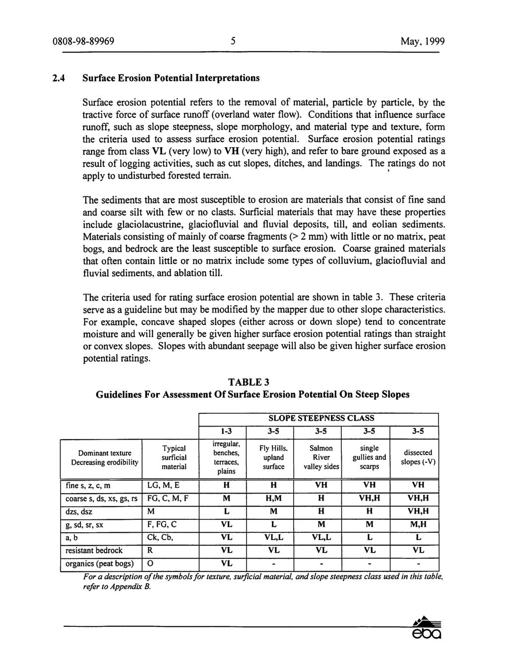
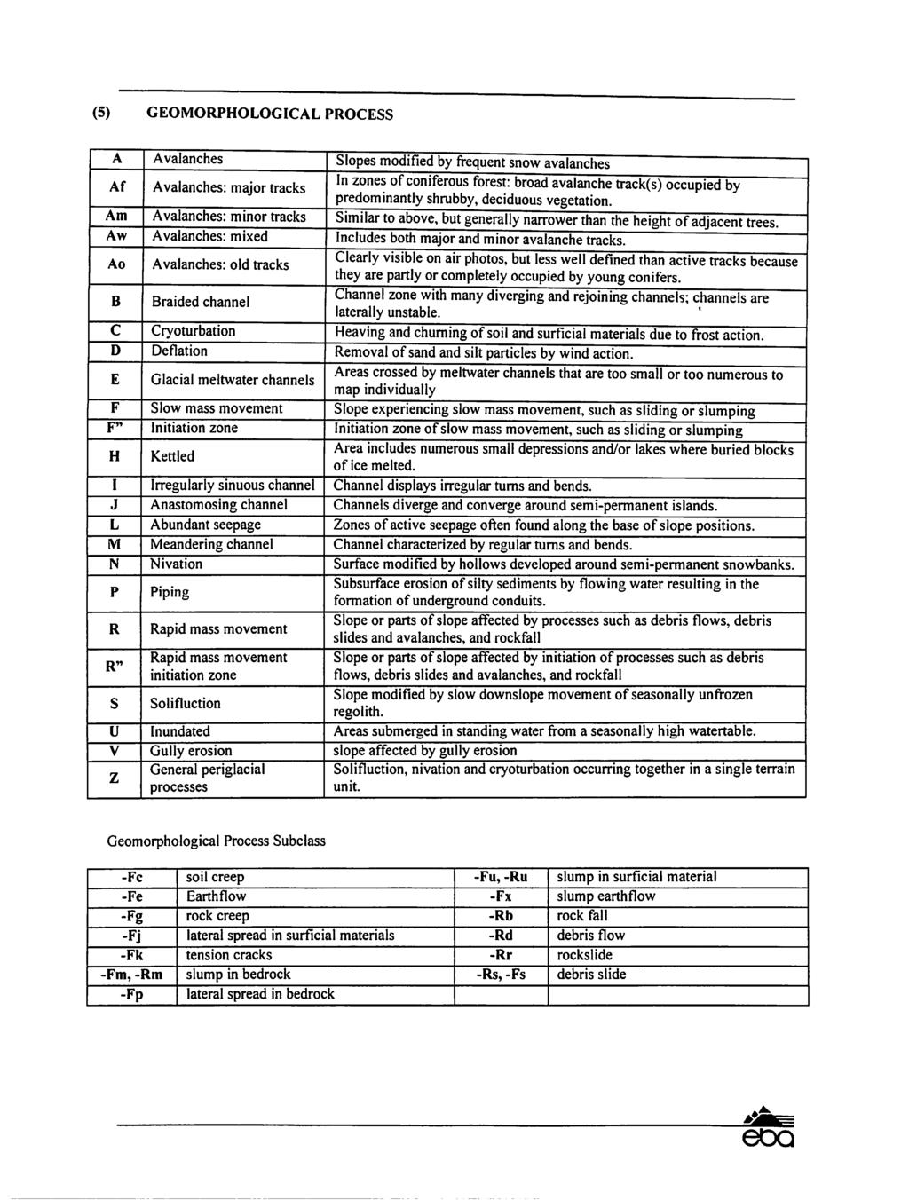
3 I T ABLE OF CONTENa-S I PAGE I 1.0 INTRODUCTION METHODS Terrain Mapping Mapping Reliability....' Terrain Stability Interpretations...: Surface Erosion Potential Interpretations Landslide-Induced Stream Sedimentation Interpretations Sediment Delivery Potential Interpretations PHySIOGRAPHy Topography and Bedrock Geology I Landscape Evolution and Deposition of Surficial Materials... 7 I 4.0 SURFICIAL MATERIALS AND ASSOCIATED LANDFORMS Till (M) Glaciofluvial Materials (FG)... ~ Colluvium (C) Fluvial Materials (F) Glaciolacustrine Materials (LG) Undifferentiated Materials (U)..., Organic Materials (0)... ~ ACTIVE GEOMORPHOLOGICAL PROCESSESl Rapid Mass Movement (-R, -R") and Slow Mass Movement (-F, -F") Debris Slides (-Rs, -R"s) and Debris! Flows (-Rd, -R" d) Rockfall (-Rb, -R"b) Slump in Bedrock (-Fm, -F"m)... l Slump-earthflow in Surficial Materi~ls (-Fx, -F"x) Gully Erosion (-V) Meltwater Channels (-E) TERRAIN STABILITY, SURFACE EROSION POTENTIAL, LANDSLIDE-INDUCED I STREAM SEDIMENTATON, AND SEDIMENT DELIVERY POTENTIAL: I DISCUSSION AND MANAGEMENT IMPLICA1iIONS Terrain Stability- Discussion... ~...: The Effects of Forest Fires on Terr~ Stability Surface Erosion Potential- Discussion... ~ The Effects of Forest Fires on Surface Erosion Potential Terrain Stability and Surface Erosion Potential- Management Implications Landslide-induced Stream Sedimentation arid Sediment Delivery I I
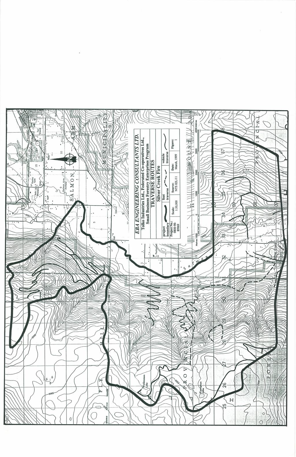
4 I I I 7.0 RECOMMENDATIONS ACKNOWLEDGMENTS...: REFERENCES CLOSURE APPENDICES Appendix A Appendix B Appendix C Appendix D... Annotated Photographs... Legend... Air photo and TRIM sheets used... Field Forms (separate document) FIGURES Figure 1... Traverse Routes Figure 2... Previous Mapping in Adjacent Watersheds Terrain and Interpretive Maps, although not bound with this document, accompany this report.

5 L' I May, INTRODUCTION, The objective of this project was to prepare detaill terrain stability maps for the area burned during the Silver Creek fire, which had not freviously been terrain mapped. This information is presented on 1 :20,000 scale tery-ain and interpretive maps. EBA Engineering Consultants Ltd. (EBA) completed lfe project for Tolko Industries Ltd., Federated Co-operatives Ltd., and the Small Business Forestry Enterprise Program, Salmon Arm Forest District. Forest Renewal BritiSl:h Columbia provided ~e funding for this project. Terrain mapping and interpretations for terrain st~ ility class, surface erosion potential class, landslide-induced stream sedimentation classj and sediment delivery potential class were carried out according to the provincial standkds (Section 2.0). Terrain mapping was done on approximately 1:15,000 scale, black! and white air photos (post-fire) and 1: 17,000 scale, colour air photos (pre-fire) by air photo interpretation, followed by field checking. This report augments the information that is sh~' on the maps completed for this project. It explains the methodology used, guidelines for assessing the interpretations, and mapping reliability (Section 2.0), and provid~1 an overview of the physiography of the study areas (Section 3.0). Additional info I ation about surficial materials and geomorphological processes (Sections 4.0 and 5.0 and a discussion of terrain stability, surface erosion potential, landslide-induced stream I sedimentation, and sediment delivery potential ratings (Section 6.0) are also included. R~commendations for forestry planning and management that arise out of this terrain analysis are discussed in Section METHODS! T. M I errald appldg I The terrain mapping methods followed the guideli~es and standards set by the Resources Inventory Committee (RIC, 1996) and the Forest Practices Code guidebook (FPC, 1995). Terrain classification followed the provincial systei (Howes and Kenk, 1997). The centre of the project area is located 10 km southwest of Salmon Arm, B.C., and includes the following watersheds: Moutell, A, B, p, Wallensteen, Kernaghan, D, Grier, the north fork of Silver Creek, and most of Wall Cr~ek and Harold's Brook totalling 8165 hectares (see Figure 1). The area burned during the fire includes Silver Creek, Gordon I Creek, and Mt. Ida well, but have been excluded from this project as they were mapped during two projects completed in 1997 (see Table ~). The project area boundary of this project edge-matches to the project area boundary ~f the mapping in adjacent watersheds (including Palmer Creek) to provide seamless terr. n mapping coverage for this area of the Salmon Arm Forest District (see Figure 2).
6

7
8
9

10
11
12

13
14

15
16
17
18
19

20
21

22
23

24

25
26
27
28
29

30

31

32
33
34
35
36
37
38
39
40
41
42
43

44
SCOTCH, KWIKOIT and CORNING CREEKS DETAILED and RECONNAISSANCE TERRAIN STABILITY MAPPING SALMON ARM FOREST DISTRICT. P. oject No.
 SCOTCH, KWIKOIT and CORNING CREEKS DETAILED and RECONNAISSANCE TERRAIN STABILITY MAPPING SALMON ARM FOREST DISTRICT P. oject No. 0808-98-89822 DETAILED and RECONNAISSANCE TERRAIN MAPPING with INTERPRETATIONS
EBA Engineering Consultants Ltd.
 EBA Engineering Consultants Ltd. CHARCOAL CREEK DETAILED TERRAIN STABILITY MAPPING (TSIL C) SALMON ARM FOREST DISTRICT RIVERSIDE FOREST PRODllCTS LIMITED EBA Project No. 0801 99 81086 #255, 1715 Dickson
EBA Engineering ConsultCfnts Ltd.
 I EBA Engineering ConsultCfnts Ltd. DETAILED TERRAIN STABILITY MAPPIN WAPCREEK RIVERSIDE FOREST PRODUCTS Lnv.DTE ARl\1STRONG DIVISION EBA Project No. 0801-01-81217 #255, 1715 Dickson Avenue, Kelowna, British
DETAILED TERRAIN MAPPING WITH INTERPRETATIONS FOR SLOPE STABILITY, EROSION POTENTIAL AND SEDIMENT TRANSFER. DILLARD CREEK FRBC Project # TO-96187
 ,, DETALED TERRAN MAPPNG WTH NTERPRETATONS FOR SLOPE STABLTY, EROSON POTENTAL AND SEDMENT TRANSFER DLLARD CREEK FRBC Project # TO-96187 Prepared by Blythe Killam, B.Sc., G..T. For Weyerhaeuser Canada Ltd.
Detailed Terrain Stability Mapping In the Ellis Creek Community Watershed and the Steward Creek Watershed, Penticton Forest District, BC
 Detailed Terrain Stability Mapping In the Ellis Creek Community Watershed and the Steward Creek Watershed, Penticton Forest District, BC Prepared for: Ministry of Forests Penticton Forest District Small
THE DIGITAL TERRAIN MAP LIBRARY: AN EXPLORATIONIST S RESOURCE
 THE DIGITAL TERRAIN MAP LIBRARY: AN EXPLORATIONIST S RESOURCE By I.C.L. Webster, P.J. Desjardins and W.E. Kilby KEYWORDS: digital terrain maps, digital terrain stability maps, surficial geology, GIS, raster
FL A ADAMS LAKE. KAMLOOPS AND CLEARWATER FOREST DISTRl 'TS TSILD RECONNAISSANCE SLOPE T ABILITY FINALREPOR. Submitted
 FL A18693 - ADAMS LAKE I KAMLOOPS AND CLEARWATER FOREST DISTRl 'TS TSILD RECONNAISSANCE SLOPE T ABILITY FINALREPOR Submitted to INTERNATIONAL FOREST PRODUCTS LTD. Adams Lake Divisibn Terratech Consulting
TEXAS CREEK AR. Prepared by. Jennifer Shypitka, B.Sc, GJ.T. For. B.C. Ministry of For sts Lillooet Forest Dist ict. January 1996
 1 1 TEXAS CREEK AR DETALED TERRAN M PPNG WTH EVALUATONS FOR SL PE STABLTY AND EROSON POTE TAL l Prepared by ennifer Shypitka, B.Sc, G.T. For B.C. Ministry of For sts Lillooet Forest Dist ict anuary 1996.M.
SALMON RIVER TRI~UT ARIES
 SALMON RVER TR~UT ARES TERRAN STABLTY REPORT {T.5.1. LEVEL 'C'}; to accompany : Terrain and Terrain Stability Maps 82L.053, 82L.054, 82L.063, 82L.06~t and 82L.073 Prepared for Riverside Forest Products
RE: COMMUNITY WATERSHEDS TERRAIN STABILITY MAPPING FRBC PROJECT # T096198a(TOLKO), VERNON FOREST DISTRICT
, VERNON FOREST DISTRICT") Golder Associates Ltd. 100. 388 First Avenue Komloops, British Columbia, Canada V2C 6W3 Telephone 1250) 828 6116 Fax 1250) 828 1215 April 17, 1998 Our ref: 962-3150 Tolko Industries Ltd. c/o Kamloops Region
Golder Associates Ltd. 100. 388 First Avenue Komloops, British Columbia, Canada V2C 6W3 Telephone 1250) 828 6116 Fax 1250) 828 1215 April 17, 1998 Our ref: 962-3150 Tolko Industries Ltd. c/o Kamloops Region
MABEL LAKE RECONNAISSANCE TERRAIN STABILITY REPORT (T.S.I. LEVEL '0') to accompany
 to accompany") MABEL LAKE RECONNAISSANCE TERRAIN STABILITY REPORT (T.S.I. LEVEL '0') to accompany Terrain Stability Maps 82L.046; 047; 056;057;058;067; 068;077; 078; 088 Prepared for Riverside Forest Products Limited
MABEL LAKE RECONNAISSANCE TERRAIN STABILITY REPORT (T.S.I. LEVEL '0') to accompany Terrain Stability Maps 82L.046; 047; 056;057;058;067; 068;077; 078; 088 Prepared for Riverside Forest Products Limited
Contrasting Behaviour of Two Recent, Large Landslides in Discontinuous Permafrost Little Salmon Lake, Yukon, Canada
 Contrasting Behaviour of Two Recent, Large Landslides in Discontinuous Permafrost Little Salmon Lake, Yukon, Canada Ryan R. Lyle BGC Engineering Inc. Kamloops, British Columbia D. Jean Hutchinson Queen
MISSION CREEK WATERSHED (2002 Report Year 4)
") Stream Channel Monitoring Program for the MISSION CREEK WATERSHED (2002 Report Year 4) (Penticton Forest District) Prepared for RIVERSIDE FOREST PRODUCTS LTD. Prepared by DOBSON ENGINEERING LTD. #4, 1960
Stream Channel Monitoring Program for the MISSION CREEK WATERSHED (2002 Report Year 4) (Penticton Forest District) Prepared for RIVERSIDE FOREST PRODUCTS LTD. Prepared by DOBSON ENGINEERING LTD. #4, 1960
Analysis of Road Sediment Accumulation to Monumental Creek using the GRAIP Method
 Analysis of Road Sediment Accumulation to Monumental Creek using the GRAIP Method Introduction (from http://www.neng.usu.edu/cee/faculty/dtarb/graip/#over): The Geomorphologic Road Analysis and Inventory
MINISTRY OF FORESTS, LANDS AND NATURAL RESOURCE OPERATIONS, POST-WILDFIRE RISK ANALYSIS PRELIMINARY REPORT
 MINISTRY OF FORESTS, ANDS AND NATURA RESOURCE OPERATIONS, POST-WIDFIRE RISK ANAYSIS PREIMINARY REPORT NOTE: The results given on this form are preliminary in nature and are intended to be a warning of
EBA Engineering Consultants Ltd. Creating and Delivering Better Solutions
 EBA Engineering Consultants Ltd. Creating and Delivering Better Solutions ENHANCING THE CAPABILITY OF ECOSYSTEM MAPPING TO SUPPORT ADAPTIVE FOREST MANAGEMENT Prepared by: EBA ENGINEERING CONSULTANTS LTD.
SECTION G SEDIMENT BUDGET
 SECTION G SEDIMENT BUDGET INTRODUCTION A sediment budget has been constructed for the for the time period 1952-2000. The purpose of the sediment budget is to determine the relative importance of different
Practical Uses of LiDAR in NL A Consultants Perspective
 Practical Uses of LiDAR in NL A Consultants Perspective Adam Anderson, R.P.F. President & CEO Presented by: Peter Davison, R.P.F. Photo Interpretation Specialist Introduction Resource Innovations Inc.
When Creek Meets Valley Wall: Prioritizing Erosion Mitigation alongside the Oshawa Landfill
 1 When Creek Meets Valley Wall: Prioritizing Erosion Mitigation alongside the Oshawa Landfill Robin McKillop 1, Dan McParland 1 & Cassie Scobie 2 TRIECA conference March 22-23, 2017 1 Palmer Environmental
POST WILDFIRE HAZARD ASSESSMENTS
 Provincial Emergency Program POST WILDFIRE HAZARD ASSESSMENTS Springer and Sitkum Creek Fires M09468A01 March 21, 2008 PROVINCIAL EMERGENCY PROGRAM Emergency Management British Columbia 455 Boleskine Road
River Nith restoration, cbec UK Ltd, October 2013 APPENDIX A
 APPENDIX A FLUVIAL AUDIT METHOD STATEMENT Fluvial Audit Methodology INTRODUCTION The procedure used to characterize the geomorphic and sedimentary regimes of the River Till is an adaptation of the Fluvial
Using Weather and Climate Information for Landslide Prevention and Mitigation
 Using Weather and Climate Information for Landslide Prevention and Mitigation Professor Roy C. Sidle Disaster Prevention Research Institute Kyoto University, Japan International Workshop on Climate and
Landscapes Prone to Rockfall, Rockslides, Debris Avalanches, Flows, and Torrents
 1) Landform Regional landscape Landscapes are qualitative indicators of unstable terrain that may be obtained from air photos, topographic maps, and limited field reconnaissance. Landscapes Prone to Rockfall,
P. Beaudry and Associates Ltd. Integrated Watershed Management
 P. Beaudry and Associates Ltd. Survey of Small and Large Sediment Sources Within the Watershed Dawson Forest District Prepared for: Chetwynd Forest Industries A Division of West Fraser Mills Ltd. P.O.
Gully Assessment Procedure Guidebook
 of BRITISH COLUMBIA Gully Assessment Procedure Guidebook Fourth edition Version 4.1 February 2001 Ministry of Forests of BRITISH COLUMBIA Gully Assessment Procedure Guidebook Fourth edition Version 4.1
Placer Potential Map. Dawson L and U se P lan. Jeffrey Bond. Yukon Geological Survey
 Placer Potential Map Dawson L and U se P lan By Jeffrey Bond Yukon Geological Survey Dawson Land Use Plan Placer Potential Map 1.0 Introduction Placer mining has been an important economic driver within
General Disclaimer. Disclaimer of Liability
 General Disclaimer The use of trade, firm, or corporation names in this publication is for the information and convenience of the reader. Such use does not constitute an official endorsement or approval
The syllabus was approved by Study programmes board, Faculty of Science on to be valid from , autumn semester 2016.
 Faculty of Science GEON05, Quaternary Geology: Glacial Sedimentology - Processes, Sediments and Landform Systems, 15 credits Kvartärgeologi: Glacial sedimentologi - processer, sediment och landformssystem,
Manitoba s Elevation (LiDAR) & Imagery Datasets. Acquisition Plans & Opportunities for Collaboration
 & Imagery Datasets. Acquisition Plans & Opportunities for Collaboration") Manitoba s Elevation (LiDAR) & Imagery Datasets Acquisition Plans & Opportunities for Collaboration Manitoba Planning Conference May 2017 Presentation Outline Manitoba s Elevation (LiDAR) and Imagery Datasets
Manitoba s Elevation (LiDAR) & Imagery Datasets Acquisition Plans & Opportunities for Collaboration Manitoba Planning Conference May 2017 Presentation Outline Manitoba s Elevation (LiDAR) and Imagery Datasets
Terrain in the LSA. Star - Orion South Diamond Project. Figure. Sas ka tche wan R. Kilometres
 Dominant Surface Material Alluvium (Av) Colluvium (C) Eolian (E) Fluvial-Lacustrine (FL) Sandy Glaciolacustrine Silty Glaciolacustrine Organic (O) Organic Veneer Y:\GIS\Projects\SX\SX03733_Shore-Gold_Diamond_1\Mapping\05_terrain-geology-soils\Baseline\05-100-001_v3.mxd
Operational Stream Channel Monitoring in Real Time
 BC Ministry of Forests Operational Stream Channel Monitoring in Real Time submitted to: Dan Hogan BC Ministry of Forests 224 Main Mall Vancouver, BC, V6T 1Z4 prepared by: : Andre Zimmermanna Sidney Tsangb
Geomorphology and Landslide Hazard Models
 Geomorphology and Landslide Hazard Models Steve Parry GeoRisk Solutions Key component of interpreting geomorphology and therefore hazard at a site is the use of API The purpose of this talk is not to try
Geology 101. Reading Guides for Chapters 5 and 14 Weathering: the Breakdown of Rocks (p. 142)
") Geology 101 Name Reading Guides for Chapters 5 and 14 Weathering: the Breakdown of Rocks (p. 142) Please read the introduction to the chapter. What is the difference between weathering and erosion? Weathering
Geology 101 Name Reading Guides for Chapters 5 and 14 Weathering: the Breakdown of Rocks (p. 142) Please read the introduction to the chapter. What is the difference between weathering and erosion? Weathering
6.0 GEOHAZARD INVENTORY
 6.0 GEOHAZARD INVENTORY A geohazard (a subset of natural hazards) is an event caused by geological features and processes that present severe threats to humans, property and natural and built environments
Bell Ringer. Are soil and dirt the same material? In your explanation be sure to talk about plants.
 Bell Ringer Are soil and dirt the same material? In your explanation be sure to talk about plants. 5.3 Mass Movements Triggers of Mass Movements The transfer of rock and soil downslope due to gravity is
Groundwater Investigation SOUTHGATE GRAVEL PIT Part of Lot 15, Concession 15 (formerly Township of Proton), Township of Southgate.
, Township of Southgate.") Groundwater Investigation SOUTHGATE GRAVEL PIT Part of Lot 15, Concession 15 (formerly Township of Proton), Township of Southgate County of Grey October, 2014 Prepared for: Drysdale Aggregate Consulting
Groundwater Investigation SOUTHGATE GRAVEL PIT Part of Lot 15, Concession 15 (formerly Township of Proton), Township of Southgate County of Grey October, 2014 Prepared for: Drysdale Aggregate Consulting
LAND DEGRADATION IN THE CARIBBEAN: QUATERNARY GEOLOGICAL PROCESSES. RAFI AHMAD
 EXTENDED TASK FORCE MEETING OF PARTICIPATING AGENCIES AND LATIN AMERICAN COUNTRIES FOR ENHANCING SOUTH-SOUTH COOPERATION BETWEEN LAC-CARIBBEAN SIDS PARTNERSHIP INITIATIVE ON LAND DEGRADATION AND SUSTAINABLE
Mass Wasting: The Work of Gravity
 Chapter 15 Lecture Earth: An Introduction to Physical Geology Twelfth Edition Mass Wasting: The Work of Gravity Tarbuck and Lutgens Chapter 15 Mass Wasting The Importance of Mass Wasting Slopes are the
GUIDELINES AND STANDARDS TO TERRAIN MAPPING IN British Columbia
 RESOURCES INVENTORY COMMITTEE APPROVED STANDARD GUIDELINES AND STANDARDS TO TERRAIN MAPPING IN British Columbia by Resources Inventory Committee Surficial Geology Task Group Earth Sciences Task Force British
Watershed Overview. 2.1 Purpose
 Watershed Overview 2.1 Purpose The purpose of this SHIM module is to develop an interim base map on which existing information can be presented, prior to initiating field mapping. This base map should
WATERSHED RESTORATION PLANNING AND PRIORITY SETTING. An Emphasis on Fish Habitat
 WATERSHED RESTORATION PLANNING AND PRIORITY SETTING An Emphasis on Fish Habitat March 2004 This document was modified from Planning and Priority Setting for the Next Five Years, Phase 3 Watershed-Level
The subject paper is being submitted for approval for publication in the annual volume entitled Geological Survey Research.
 Water Resources Division 345 Middlefield Road Menlo Park, California January 12, 1965 Memorandum To: Mr. Frank E. Clark, Chief, General Hydrology Branch Thru: Area Hydrologist PCA From: Valmore C. LaMarche
Archaeological Predictive Modeling within the context of Paleo-river Terraces in the City of Prince George
 Archaeological Predictive Modeling within the context of Paleo-river Terraces in the City of Prince George Background The documented pre-contact archaeological record of the Interior Plateau of B.C. is
Monitoring Program Terms of Reference HERITAGE AND CULTURE INFORMATION PLAN
 Monitoring Program Terms of Reference HERITAGE AND CULTURE INFORMATION PLAN GMSMON-21a Peace - Archaeological Overview Assessment May 2, 2008 1.0 OVERVIEW HERITAGE AND CULTURE INFORMATION PLAN TERMS OF
Fluvial Geomorphic Guidelines
 Fluvial Geomorphic Guidelines FACT SHEET I: GEOMORPHOLOGICAL HAZARDS CONFINED AND UNCONFINED WATERCOURSES Channel migration and erosion can create substantial risk to inappropriately located infrastructure
NEW PRODUCTS AND ADVANCEMENTS IN 3-D MODELLING PROTOCOLS BASED ON STUDIES IN THICK DRIFT AREAS IN ONTARIO, CANADA
 NEW PRODUCTS AND ADVANCEMENTS IN 3-D MODELLING PROTOCOLS BASED ON STUDIES IN THICK DRIFT AREAS IN ONTARIO, CANADA Abigail K. Burt and Andrew F. Bajc Ontario Geological Survey, 933 Ramsey Lake Road, Sudbury,
Our File: 92 F/1, 92 F/8. Numerous licenced springs occur north of the B.C. Hydro right-of-way on. Water Management Branch
 J.C. Foweraker, Head Groundwater Section Water Management Branch Date: May 23, 1986 Our File: 92 F/1, 92 F/8 Re: Groundwater - D.L. 117. Nanoose District As requested by Mr. B. Hollingshead, Regional Water
Channel Morphology in Carnation Creek: 2009 Survey Results
 Research Branch BC Ministry of Forests Channel Morphology in Carnation Creek: submitted to: Dan Hogan BC Ministry of Forests Rm 315 2202 Main Mall Vancouver B.C. V6T 1Z4 prepared by: Stephen Bird White
ENGINEERING EVALUATION OF THE STANLEY MINE ADVENTURE PARK AREA CLEAR CREEK COUNTY, COLORADO. Prepared for:
 braun Braun Consulting Engineers ENGINEERING EVALUATION OF THE STANLEY MINE ADVENTURE PARK AREA CLEAR CREEK COUNTY, COLORADO Prepared for: STANLEY MINES ADENTURE PARK 3375 W. POWERS CIRCLE LITTLETON, COLORADO
Chapter 11 10/30/2013. Mass Wasting. Introduction. Factors That Influence Mass Wasting. Introduction. Factors That Influence Mass Wasting
 Introduction Chapter 11 Mass wasting - The downslope movement of material resulting from the force of gravity. Mass Wasting Mass wasting results when the force of gravity acting on a slope exceeds the
Appendix E Rosgen Classification
 Appendix E Stream Type s Using the morphometric parameters described above, stream reaches are classified into 7 major stream types (Aa+ through G) based on s (1996) criteria. The relevant stream classifications
GOAL 7 AREAS SUBJECT TO NATURAL DISASTERS AND HAZARDS. To protect life and property from natural disasters and hazards.
 GOAL 7 AREAS SUBJECT TO NATURAL DISASTERS AND HAZARDS A. GOALS: To protect life and property from natural disasters and hazards. B. POLICIES: 1. Floodplains shall be maintained as natural drainage-ways.
Columbia River Project Water Use Plan. Monitoring Program Terms of Reference HERITAGE MANAGEMENT PLAN
 HERITAGE MANAGEMENT PLAN CLBMON-50 Arrow Lakes Reservoir Heritage Monitoring Wind and Wave Erosion 23 October 2007 1.0 OVERVIEW HERITAGE MANAGEMENT PLAN TERMS OF REFERENCE This document presents Terms
9/13/2011 CHAPTER 9 AND SUBSIDENCE. Case History: La Conchita Landslide. Introduction
 CHAPTER 9 SLOPE PROCESSES, LANDSLIDES, AND SUBSIDENCE Case History: La Conchita Landslide La Conchita: small coastal community 80 km (50 mi) northwest of Los Angeles Landslide occurred on January 10, 2005
BCTS BC TIMBER SALES STRAIT OF GEORGIA BUSINESS AREA
 Terrain Stability Assessment Additional area added to Cutblock C34M McNab Creek PREPARED FOR: BCTS BC TIMBER SALES STRAIT OF GEORGIA BUSINESS AREA PREPARED BY: COAST OPERATIONS #213-1720 14TH AVE. CAMPBELL
UNRAVELING THE HISTORY OF A LANDSCAPE: Using geomorphology, tephrochronology, and stratigraphy. Photo by: Josh Roering
 UNRAVELING THE HISTORY OF A LANDSCAPE: Using geomorphology, tephrochronology, and stratigraphy Photo by: Josh Roering Photo: Eric Bilderback Photo by: Josh Roering Goal 1. Reconstruct the paleo-landscape
Dan Miller + Kelly Burnett, Kelly Christiansen, Sharon Clarke, Lee Benda. GOAL Predict Channel Characteristics in Space and Time
 Broad-Scale Models Dan Miller + Kelly Burnett, Kelly Christiansen, Sharon Clarke, Lee Benda GOAL Predict Channel Characteristics in Space and Time Assess Potential for Fish Use and Productivity Assess
Swift Creek Sediment Management Action Plan (SCSMAP)
") Swift Creek Sediment Management Action Plan (SCSMAP) PHASE 2 PROJECT PLAN PROPOSAL Whatcom County Public Works Department 322 N. Commercial Street, Suite 210 Bellingham, WA 98225 (360) 676-6692 June 2013
Swift Creek Sediment Management Action Plan (SCSMAP) PHASE 2 PROJECT PLAN PROPOSAL Whatcom County Public Works Department 322 N. Commercial Street, Suite 210 Bellingham, WA 98225 (360) 676-6692 June 2013
Channel Assessments of Selected Watersheds within TFL 52
 Channel Assessments of Selected Watersheds within TFL 52 prepared for: West Fraser Mills Ltd. Quesnel, BC prepared by: John Berry, M.Sc., R.P.F. Victoria, BC Channel Assessments TFL 52 Summary SUMMARY
,Baynes Lake. TO...?&.?...A 2...KO.?'!!&... Sr. *logical Engineer
 > i evernment OF BRITISH COLUMBIA a TO...?&.?...A 2....KO.?'!!&... Sr. *logical Engineer... Grou,,water. Section Hydrology Division Wat.er... In~.~s.tiga.ti.On.s..Branck.... 5 u BJECT...C;.roun.dw.ater...Snve
PHASE 1 STUDIES UPDATE EROSION WORKING GROUP
 PHASE 1 STUDIES UPDATE EROSION WORKING GROUP Presented By MICHAEL WOLFF, PG Erosion Study Area Manager West Valley Demonstration Project Quarterly Public Meeting February 24, 2016 OUTLINE Study 1 Terrain
SECTION A MASS WASTING
 SECTION A MASS WASTING INTRODUCTION This section summarizes the methods and results of a mass wasting assessment conducted on the Mendocino Redwood Company, LLC (MRC) ownership in the Ackerman Creek and
(Final revised draft submitted to Environmental and Engineering Geoscience, 20 April 2009.)
") (Final revised draft submitted to Environmental and Engineering Geoscience, 20 April 2009.) Debris flows and floods following the 2003 wildfires in southern British Columbia Peter Jordan 1 and S. Ashley
(Final revised draft submitted to Environmental and Engineering Geoscience, 20 April 2009.) Debris flows and floods following the 2003 wildfires in southern British Columbia Peter Jordan 1 and S. Ashley
The Importance of Mass Wasting
 Mass Wasting: The Work of Gravity Earth Chapter 15 Chapter 15 Mass Wasting The Importance of Mass Wasting Slopes are the most common elements in our physical landscape Slopes may appear to be stable, but
Re: Steep Slope Assessment for 2465 Waverly Drive, Blind Bay, BC; Legal Address: Lot 39, Section 18, Township 22, Range 10, Plan 25579, W6M, KDYD.
 OEL File 1563-1 May 30, 2017 Doug Wall PO Box 774 Salmon Arm, BC V1E 4N7 Re: Steep Slope Assessment for 2465 Waverly Drive, Blind Bay, BC; Legal Address: Lot 39, Section 18, Township 22, Range 10, Plan
Forest Research. Vancouver Forest Region 2100 Labieux Road, Nanaimo, BC, Canada, V9T 6E9,
 Forest Research Technical Report Vancouver Forest Region 2100 Labieux Road, Nanaimo, BC, Canada, V9T 6E9, 250-751-7001 TR-025 Geomorphology March 2003 Schmidt Creek Sediment Sources and the Johnstone Strait
Geology 101. Reading Guides for Chapters 6 and 12
 Geology 101 Name Chapter 6: Weathering and Soils (p. 160): Reading Guides for Chapters 6 and 12 This chapter is about the processes involved in the disintegration of rock. Weathering is often mistaken
Remote Sensing Technologies For Mountain Pine Beetle Surveys
 Remote Sensing Technologies For Mountain Pine Beetle Surveys Michael Wulder and Caren Dymond Natural Resources Canada, Canadian Forest Service, Pacific Forestry Centre, 506 West Burnside Road, Victoria,
Erosion and Deposition
 Erosion and Deposition Erosion Sediment natural forces move rock/soil from one place to another. gravity, water, wind, glaciers, waves are causes material moved by erosion Deposition when erosion lays
MANAGEMENT OF LARGE MUDSLIDES
 36 MANAGEMENT OF LARGE MUDSLIDES Three large and active mudslides Poche, 1860?, Super-Sauze, 1960?, La Valette, March 1982, 1 M m 3 900,000 m 3 4-5 M m 3 37 Three large and active mudslides Type of development:
April Version 1.0. Prepared by
 British Columbia Archaeological Inventory Guidelines Prepared by Ministry of Small Business, Tourism and Culture Archaeology Branch for the Culture Task Force Resources Inventory Committee April 2000 Version
Mass Wasting. Mass Wasting. Earth s s External Processes
 1 Mass Wasting Presentation Modified from Instructor Resource Center on CD-ROM, Foundations of Earth Science, 4 th Edition, Lutgens & Tarbuck Mass Wasting 2 Down-slope movement of rock, loose material
Association of State Floodplain Managers, Inc.
 Association of State Floodplain Managers, Inc. 2809 Fish Hatchery Road, Suite 204, Madison, WI 53713 Phone: 608-274-0123 Fax: 608-274-0696 Email: asfpm@floods.org Website: www.floods.org Need for Updating
Monitoring Headwater Streams for Landscape Response to
 Monitoring Headwater Streams for Landscape Response to Climate Change Matthew Connor, PhD Connor nvironmental, nc. www.oe-i.com icom Healdsburg, California verview Headwater stream geomorphology Response
Geomorphology Of The Chilliwack River Watershed Landform Mapping At North Cascades National Park Service Complex, Washington By National Park Service
 Geomorphology Of The Chilliwack River Watershed Landform Mapping At North Cascades National Park Service Complex, Washington By National Park Service READ ONLINE Snowshed contributions to the Nooksack
CAUSES FOR CHANGE IN STREAM-CHANNEL MORPHOLOGY
 CAUSES FOR CHANGE IN STREAM-CHANNEL MORPHOLOGY Chad A. Whaley, Department of Earth Sciences, University of South Alabama, MobileAL, 36688. E-MAIL: caw408@jaguar1.usouthal.edu The ultimate goal of this
OBJECTIVES. Fluvial Geomorphology? STREAM CLASSIFICATION & RIVER ASSESSMENT
 STREAM CLASSIFICATION & RIVER ASSESSMENT Greg Babbit Graduate Research Assistant Dept. Forestry, Wildlife & Fisheries Seneca Creek, Monongahela National Forest, West Virginia OBJECTIVES Introduce basic
Geologic Management. Contents
 Geologic Management Contents Introduction... GM-3 Definitions... GM-3 Legislation and Other Guidance... GM-3 Policy Management for Representation... GM-5... GM-5 Inventory of Significant Geologic Features
Prospecting Report Grandpa Claim Group
 2010 2011 Prospecting Report Grandpa Claim Group TENURE NUMBER: 705523 EVENT NUMBER: 4825383 TENURE NAME: GRANDPA Lillooet Mining Division Map 092I Central Coordinate Reference 50 57 30 N Latitude 121
1.0 INTRODUCTION 2.0 OBSERVATIONS EBA FILE: W nd Avenue Whitehorse, YT Y1A 1C2. Attention:
 August 5, 2013 City of Whitehorse 2121 2 nd Avenue Whitehorse, YT Y1A 1C2 ISSUED FOR USE EBA FILE: W14103182-01 Via Email: ben.campbell@whitehorse.ca Attention: Subject: Ben Campbell, Planner II Planning
What is a watershed or landscape perspective?
 What is a watershed or landscape perspective? -remove sediment -add sediment -add wood, riparian manipulation -alter (engineer) channel/floodplain morphology -restore/abandon roads You are here What is
Science Matters. Grade Six Earth Science. Weathering and Erosion
 Science Matters Grade Six Earth Science Weathering and Erosion Written By Kim Castagna Jennifer Foster Meagan Callahan Tracy Schifferns Developed in Conjunction with K-12 Alliance/WestEd Table of Contents
Internet Mapping Framework 1 (IMF) to Common Web Mapping (CWM) Legend Comparison
 to Common Web Mapping (CWM) Legend Comparison") Internet Mapping Framework 1 (IMF) to Common Web Mapping () Legend Comparison IMF Legend Legend Folders Titles (MTO) - Mineral, Placer, Coal Map Viewers.. 3 Coal Grid - Coal Map Viewer. 4 Tenure History
Internet Mapping Framework 1 (IMF) to Common Web Mapping () Legend Comparison IMF Legend Legend Folders Titles (MTO) - Mineral, Placer, Coal Map Viewers.. 3 Coal Grid - Coal Map Viewer. 4 Tenure History
Landslide/Flood Hazard Areas B & C October 13, 2016 Page 2 of 3
 Landslide/Flood Hazard Areas B & C October 13, 2016 Page 2 of 3 explained that she has shared this study with Island Timberlands, Western Forest Products and BC Timber Sales and made it clear that their
Final Report. March
 Inuvik to Tuktoyaktuk Highway - Baseline Data Acquisition Program Final Report Prepared for: Government of the Northwest Territories Department of Transportation Yellowknife, NT Prepared by: KAVIK-STANTEC
ENVIRONMENTAL GEOSCIENCE UNIFORM SYLLABUS
 ENVIRONMENTAL GEOSCIENCE UNIFORM SYLLABUS The Association of Professional Engineers and Geoscientists of the Province of British Columbia Note: 1. This Syllabus May Be Subject To Change 2. These Courses
THE CASPAR CREEK EXPERIMENTAL WATERSHED. Thomas Lisle, Hydrologist Pacific Southwest Forest and Range Experiment Station Arcata, Califorina
 THE CASPAR CREEK EXPERIMENTAL WATERSHED Thomas Lisle, Hydrologist Pacific Southwest Forest and Range Experiment Station Arcata, Califorina The Caspar Creek Experimental Watershed was set up as a traditional
Mark Hawley, Piteau Associates Engineering Ltd. John Cunning, Golder Associates Ltd.
 Introducing: GUIDELINES FOR MINE WASTE DUMP AND STOCKPILE DESIGN Editors: Mark Hawley, Piteau Associates Engineering Ltd. John Cunning, Golder Associates Ltd. 8 November 2017 Sponsorship 8 November 2017
Chapter 1 Overview of Maps
 Chapter 1 Overview of Maps In this chapter you will learn about: Key points when working with maps General types of maps Incident specific maps Map legend and symbols Map sources A map is a navigational
Welcome to NetMap Portal Tutorial
 Welcome to NetMap Portal Tutorial Potential Applications What Can you do with the Portal? At least 25 things! 1) Locate the best potential fish habitats. 2) Identify biological hotspots. 3) Map floodplain
Monitoring Program Terms of Reference HERITAGE AND CULTURE INFORMATION PLAN
 Monitoring Program Terms of Reference HERITAGE AND CULTURE INFORMATION PLAN GMSMON-21b Peace Erosion Monitoring of Archaeological Resources May 2, 2008 1.0 OVERVIEW HERITAGE AND CULTURE INFORMATION PLAN
Mass Movements, Wind, and Glaciers
 Mass Movements,, and Glaciers SECTION 8.1 Mass Movement at Earth s Surface In your textbook, read about mass movement. Use each of the terms below just once to complete the passage. avalanche creep landslide
1 INTRODUCTION AND MAJOR FINDINGS... 1
 Memorandum To: Lindsey Clark, Stillwater Valley Watershed Council Coordinator From: Chad Raisland, Pioneer Technical Services, Inc. and Karin Boyd, Applied Geomorphology, Inc. CC: Tanya Lester, Stillwater
Mass Wasting. Revisit: Erosion, Transportation, and Deposition
 Mass Wasting Revisit: Erosion, Transportation, and Deposition While landslides are a normal part of erosion and surface processes, they can be very destructive to life and property! - Mass wasting: downslope
Clyde River Landslide
 Clyde River Landslide Department of Geology, Perkins Hall, University of Vermont, Burlington, VT 05405 Abstract: This paper investigates a landslide on the Clyde River in Newport, Vermont. The landslide
TERRAIN STABILITY ASSESSMENT SOIL EROSION ASSESSMENT. Proposed Perry Ridge North (PN) Forest Roads: Mainline Extension; 11000; 11030; and 11040
 Forest Roads: Mainline Extension; 11000; 11030; and 11040") TERRAIN STABILITY ASSESSMENT SOIL EROSION ASSESSMENT Proposed Perry Ridge North (PN) Forest Roads: Mainline Extension; 11000; 11030; and 11040 Selkirk Forest District Prepared for: British Columbia Timber
TERRAIN STABILITY ASSESSMENT SOIL EROSION ASSESSMENT Proposed Perry Ridge North (PN) Forest Roads: Mainline Extension; 11000; 11030; and 11040 Selkirk Forest District Prepared for: British Columbia Timber
EFFECTS OF RIPARIAN RETENTION (IN WATERSHEDS) ON ALLUVIAL FANS
 ON ALLUVIAL FANS") EFFECTS OF RIPARIAN RETENTION (IN WATERSHEDS) ON ALLUVIAL FANS TIM GILES GEOMORPHOLOGIST FLNRO EFFECTS OF RIPARIAN RETENTION (IN WATERSHEDS) ON ALLUVIAL FANS Description of alluvial fans Three case studies
EFFECTS OF RIPARIAN RETENTION (IN WATERSHEDS) ON ALLUVIAL FANS TIM GILES GEOMORPHOLOGIST FLNRO EFFECTS OF RIPARIAN RETENTION (IN WATERSHEDS) ON ALLUVIAL FANS Description of alluvial fans Three case studies
Best Management Practices for Coldwater Fisheries Enhancement and Restoration
 Best Management Practices for Coldwater Fisheries Enhancement and Restoration MACC Annual Environmental Conference 2017 March 3, 2017 Tim Dexter, MassDOT Highway Division 1 Leading the Nation in Transportation
Vermont Stream Geomorphic Assessment. Appendix E. River Corridor Delineation Process. VT Agency of Natural Resources. April, E0 - April, 2004
 Vermont Stream Geomorphic Assessment Appendix E River Corridor Delineation Process Vermont Agency of Natural Resources - E0 - River Corridor Delineation Process Purpose A stream and river corridor delineation
General Disclaimer. Disclaimer of Liability
 General Disclaimer The use of trade, firm, or corporation names in this publication is for the information and convenience of the reader. Such use does not constitute an official endorsement or approval