MINISTRY OF FORESTS, LANDS AND NATURAL RESOURCE OPERATIONS, POST-WILDFIRE RISK ANALYSIS PRELIMINARY REPORT
|
|
|
- Moses May
- 5 years ago
- Views:
Transcription
1 MINISTRY OF FORESTS, ANDS AND NATURA RESOURCE OPERATIONS, POST-WIDFIRE RISK ANAYSIS PREIMINARY REPORT NOTE: The results given on this form are preliminary in nature and are intended to be a warning of potential hazards and risks. It is not a final risk analysis and further work may alter the conclusions. Please contact the author for more information. FIRE: N50320 Slocan Park FIRE YEAR: 2014 DATE OF REPORT: 10 Sept AUTHOR: Peter Jordan REPORT PREPARED FOR: Selkirk Resource District (Arrow-Boundary FD), and Southeast Fire Centre FIRE SIZE, OCATION, AND AND STATUS: 90 ha. Fire is on upper part of Slocan Ridge, about 3 km east of Slocan Park. Crown land. VAUES AT RISK: Several houses along Hwy 6 near Radcliffe Creek and unnamed creek to SE, may vulnerable to flooding or possible debris flow hazard. One water intake on Radcliffe Creek. WATERSHEDS AFFECTED: Radcliffe Creek (watershed 1) unnamed creek (watershed 2) TOTA AREA 619 ha 220 ha AREA BURNED 25.4 ha 63.8 ha BURN SEVERITY 12% H, 12% M, 76% 4% H, 20% M, 76% (of area burned) SUMMARY OF HAZARDS AND RISKS: Hazard: There is a pre-existing moderate hazard of debris flows on Radcliffe Creek. There is a low to moderate hazard of debris flows on creek 2. Incremental hazard due to the fire is low on both creeks. (See attached report for details.) Risks: 1. Risk to houses and highway near mouth of Radcliffe Cr consequence is moderate, as debris flows are likely to be deposited on fan on the bench upstream. The preexisting (pre-fire) risk is low; the incremental risk due to the fire is also low. 2. Possible risk to houses and farm buildings near mouth of creek 2, from flooding or debris flow runout. Consequence is probably low, as buildings are on low-gradient land, not close to the creek channel. Pre-existing and incremental risks are low. 3. Moderate pre-existing risk to water intake on Radcliffe Cr, not significantly increased by the fire. HAZARD 1 RISK 2 M 1. Hazard = P(H), the probability of occurrence of a hazardous event 2. Risk = Partial risk P(HA) = P(H) the probability of it reaching or affecting an element at risk FURTHER ACTIONS: none POTENTIA MITIGATION: none COMMENTS: The risk table above gives the incremental hazard and risk due to the fire. There is already a moderate hazard and risk to houses and water intake on Radcliffe Cr, from possible debris flows or flooding. The fire increases the hazard only slightly, because of limited burn area and mostly low burn severity. Debris flow or flood hazard could occur during intense summer thunderstorms, or during spring snowmelt. SIGNATURE: Peter Jordan, P.Geo. ATTACHMENTS: See attached report and map for further details. Southern Interior Forest Region, preliminary report form version 1.0, 22 July 2010
2
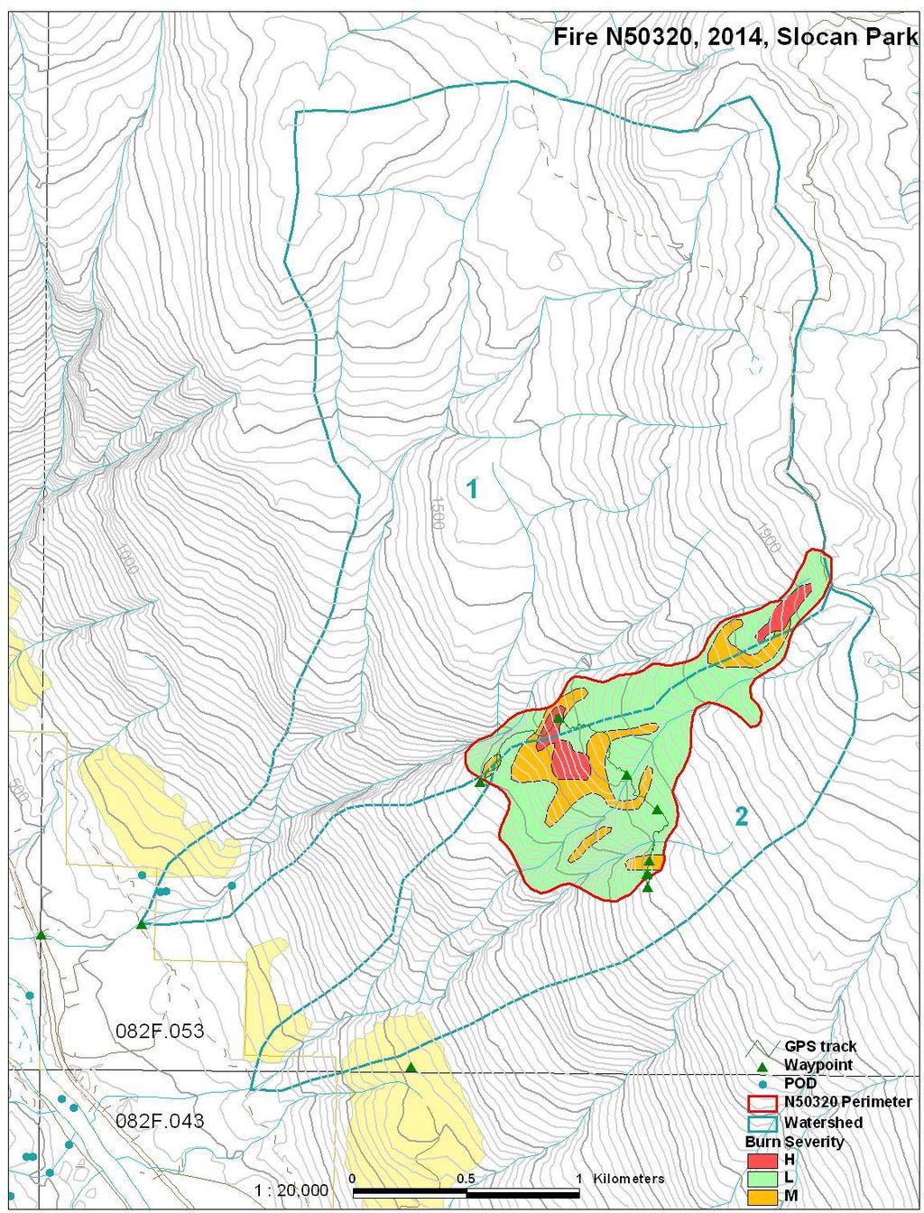
3 Post-Wildfire Risk Analysis, Fire N50320, Slocan Park further details Peter Jordan, P.Geo., MFNRO, Nelson 12 Sept 2014 Introduction and methods This memo gives further information on the Slocan Park fire, and possible debris flow and flood risks on two creeks draining the burned area. A summary of the risk analysis is given on the accompanying form. The Slocan Park fire started on 3 August 2014, and burned until late August. It is located high on the slopes of Slocan Ridge, between about 1300 and 1950 m elevation, above part of the Slocan Park community. At the request of the Southeast Fire Centre, I did a natural hazards risk analysis of the fire. On August 28, I did a field review of the fire. This consisted of taking photographs from the air, and a ground traverse across the burned area. I also inspected the creek channel of Radcliffe Creek in the valley bottom on September 4, and reviewed air photos and 1:5000 floodplain maps of the Slocan Valley in the area below the fire. Burned area observations The attached map (Figure 1) shows the burned area and the two watersheds draining it. Burn severity was mapped from photos taken from the air on August 28, with ground checking of representative sites on the same day. The fire occupies about 4% of the watershed area of Radcliffe Creek, and 29% of the watershed area of creek 2. About 6% of the fire (and only 0.5% and 1.2% of the two watersheds respectively) is burned at high severity. The table below summarizes the burned area and burn severity by watershed. Watershed: Radcliffe Creek (1) unnamed (creek 2) area (ha) elevation range (m) relief ratio* burn area (ha) [% of watershed] 25.4 [4.1%] 63.8 [29.1%] H severity 3.0 [0.5%] 2.6 [1.2%] M severity 3.2 [0.5%] 12.9 [5.9%] severity or unburned 19.2 [3.1%] 48.3 [22.0%] * The Melton relief ratio is the elevation range divided by the square root of area. A relief ratio over 0.6 can indicate a watershed is susceptible to debris flows.
4 Burn severity as noted in the table is vegetation burn severity, or the extent of canopy burn, which is what can be interpreted from the air. Soil burn severity can only be assessed on the ground. Criteria for interpreting burn severity are given in Curran et al (2006). Ground observations of burn severity showed that water repellent soils were present in some high severity burned areas, but they were patchy in nature. It was estimated that strong water repellency occurred over about 20% of high burn severity areas, and rarely in moderate burn severity areas. In some high vegetation burn severity areas, remnants of charred duff (forest floor) remained (i.e. soil burn severity was only moderate). In much of the burned areas, the fire skipped over rocky ground. Compared with other fires that have caused problems with postwildfire debris flows (for example, the 2007 Springer fire and the 2003 Kuskonook fire), soil burn severity in this fire is considerably less. There is a patch, about 2 ha in area, of high severity burn at the top of the fire (a separate fire start), which was not checked in the field. From the air, this patch appeared to have higher soil burn severity than was seen in the lower part of the fire. There is very little soil disturbance due to firefighting activities. On the hose lines, only vegetation was cleared, and the forest floor is mostly undisturbed. The helipads are on rocky ground with minimal soil disturbance. Debris flow and flood hazards and risks Debris flows and floods following wildfires can occur in summer as a result of high-intensity rainfall on water-repellent soils (for example, the 2004 Kuskonook Creek debris flow which followed the 2003 fire). This hazard is greatest in the one to two years after the fire. Debris flows and floods can also occur during spring runoff as a result of rapid snowmelt in burned areas (for example, the debris flows in Van Tuyl and Memphis Creeks which occurred in 2008, 2009, and 2010, following the 2007 Springer fire). This hazard is due to increased snow accumulation, more rapid snowmelt, and higher groundwater levels in burned areas, and can persist for many years until revegetation occurs. Both creeks appear to be subject to debris flows, but these are probably rare, and there is no indication from the channels or valley bottom deposits that any debris flows have occurred in historic time. The fire and adjacent creek channels are on steep (40-70%), mainly rocky, ground. Creek 2 has two branches in the fire (photo 1). Where inspected in the field, the channel bed and banks were in bedrock or coarse colluvium, and there appeared to be little material that could be entrained in a debris flow. Also, the creek channels are bordered by a strip of unburned or lightly burned vegetation and intact soil, probably because of moister soil conditions than on nearly high ground. This makes it unlikely that a debris flow would start in the burned area. The high elevation, high burn severity patch (photo 3), sits on a steep slope above a small, steep tributary of Radcliffe Creek. There is a remote possibility that if a small landslide occurred in this burned patch, it could trigger a small debris flow which could descend Radcliffe Creek.
5 Below the fire, the ground is steep and rocky down to about the 600 m level, where there is an irregular bench of eroded glaciofluvial terraces, followed by the power line. Below this, there is a short slope, above the flat land along the Slocan River, which is densely developed with homes and small farms. I inspected the Radcliffe Creek channel on the bench and at the highway. I was unable to inspect the lower channel of creek 2 due to lack of access through private land along the power line, and its location is not apparent along the highway. Both creeks were dry at the time. For watershed calculations, the point of interest on both creeks is arbitrarily defined at the power line road. On the bench on lower Radcliffe Creek, there is an alluvial fan, which probably consists of both debris flow and flood deposits. It appears to be inactive in recent time, and was probably covered with mature forest (it is now disturbed by logging and gravel pit development). The creek then drops down a narrow confined channel to the highway. Near the highway, the creek has an active, cobble-boulder channel with about a 5 to 7% slope. It appears likely that any debris flow in Radcliffe Creek would deposit most or all of its debris on the upper fan, and carry only flood deposits to the highway. The highway and power line roads both cross the creek with culverts of adequate size (about 1.2 m) to carry flood flows, but they could be blocked by woody debris in the event of a debris flow. The Radcliffe Creek upper fan and lower channel are designated hazard polygons on MOE (now MFNRO) alluvial fan hazard maps. There is at least one house adjacent to the lower creek channel. From viewing air photos and the detailed Slocan River floodplain maps, it appears that creek 2 has a small, gently-sloping (<10%) alluvial fan at the edge of the Slocan River flats. Its course below the fan is not obvious; it is probably diverted in ditches through the farmland. There are no houses on the fan; several houses and farm buildings are located on flat land between the fan and the highway, or on adjacent low terraces. In the event of a debris flow on creek 2, it would probably deposit where the creek crosses the upper bench, and it appears unlikely that flood deposits reaching the lower fan could affect any houses or the highway. There is one water intake on Radcliffe Creek, with four water licenses, located above the fan. It would be at risk in the event of a debris flow or large flood. Conclusions On both Radcliffe Creek and creek 2, there is a pre-existing (before the fire) low to moderate hazard of debris flows reaching the populated valley bottom. The incremental hazard due to the fire is low, because of the small area of the watershed that has been burned, and limited extent of high-severity burn. Nearby houses are unlikely to be impacted by a debris flow on either creek. Therefore, the incremental risk due to the fire to houses, other improvements, and the highway is rated as low. In the unlikely event that a debris flow or flood were to occur in the southernmost tributary of Radcliffe Creek due to the burn, the water intake could be affected.
6 Figures Figure 1. Map of Slocan Park fire and adjacent watersheds. (at end of report) Figure 2. Example of a qualitative risk matrix. From Wise et al (2004). Photos: on following pages References The following are general references or reports for nearby locations. Most are available on the internet at this location: ftp://ftp.for.gov.bc.ca/rsi/external/!publish/wildfire_risk_analysis/ Curran, M.P., Chapman B., Hope G.D., and Scott D arge-scale Erosion and Flooding after Wildfires: Understanding the Soil Conditions. BC Ministry of Forests and Range, Technical Report 030. Jordan, P Post-wildfire landslides in southern British Columbia. Proceedings, 11th International & 2nd North American Symposium on andslides, Banff, Alberta, Canada, 3-8 June, 2012, pp Jordan, P Sediment yields and water quality effects of severe wildfires in southern British Columbia. Wildfire and Water Quality: Processes, Impacts and Challenges. IAHS Publ. 354, pp Jordan, P. and Gluns, D Sitkum Creek Fire, 2007, N70347, Post-Wildfire Risk Analysis. Report prepared for BC Ministry of Forests and Range, Southeast Fire Centre, Southern Interior Forest Region, and Kootenay ake Forest District, 17 September, Nicol, D., Jordan, P., and Deschenes, M Springer Creek Fire Number Post-Wildfire Risk Analysis. Report prepared for BC Ministry of Forests and Range, Southern Interior Forest Region, 14 September, Wise, M.P., Moore, G.D., and VanDine, D.F. (eds.) andslide Risk Case Studies in Forest Development Planning and Operations. BC Ministry of Forests, and Management Handbook 56.


7 Photo 1. Overview of Fire 320, taken on 28 August Radcliffe Creek is on left; the two branches of creek 2 are in lower centre. Photo 2. Patchy burn in rocky terrain in upper part of the fire.

;")


8 Photo 3. Patch of high-severity burn in upper part of the fire, above Radcliffe Creek tributary (right); looking down the slope toward Slocan River. Photo 4. Moderate severity burn in lower part of the fire. Note natural mulching from needle fall, which protects the soil from erosion.
MINISTRY OF FORESTS, LANDS AND NATURAL RESOURCE OPERATIONS, POST-WILDFIRE RISK ANALYSIS PRELIMINARY REPORT
 INISTRY OF FORESTS, ANDS AND NATURA RESOURCE OPERATIONS, POST-WIDFIRE RISK ANAYSIS PREIINARY REPORT NOTE: The results given on this form are preliminary in nature and are intended to be a warning of potential
Post-Wildfire Risk Analysis, Fire N70261, 2015, Sitkum-Duhamel. Peter Jordan, P.Geo., MFLNRO, Nelson 22 Sept 2015
 Post-Wildfire Risk Analysis, Fire N70261, 2015, Sitkum-Duhamel Peter Jordan, P.Geo., MFLNRO, Nelson 22 Sept 2015 Introduction and methods This memo gives further information on post-wildfire natural hazards
Water, Earth, and Fire: Runoff, Erosion and Landslides after Wildfire in Southern British Columbia. Peter Jordan B.C. Forest Service, Nelson, BC
 Water, Earth, and Fire: Runoff, Erosion and Landslides after Wildfire in Southern British Columbia Peter Jordan B.C. Forest Service, Nelson, BC Research Seminar Series, 15 March 2011 Introduction and Background:
BC Ministry of Forests, Lands, and Natural Resource Operations and Rural Development
 Suite #3, 385 Baker Street Nelson, BC, V1L 4H6 250 509 1009 BC Ministry of Forests, Lands, and Natural Resource Operations and Rural Development POST-WILDFIRE NATURAL HAZARDS RISK ANALYSIS ELEPHANT HILL
Natural hazards in Glenorchy Summary Report May 2010
 Natural hazards in Glenorchy Summary Report May 2010 Contents Glenorchy s hazardscape Environment setting Flood hazard Earthquakes and seismic hazards Hazards Mass movement Summary Glossary Introduction
POST WILDFIRE HAZARD ASSESSMENTS
 Provincial Emergency Program POST WILDFIRE HAZARD ASSESSMENTS Springer and Sitkum Creek Fires M09468A01 March 21, 2008 PROVINCIAL EMERGENCY PROGRAM Emergency Management British Columbia 455 Boleskine Road
EFFECTS OF RIPARIAN RETENTION (IN WATERSHEDS) ON ALLUVIAL FANS
 ON ALLUVIAL FANS") EFFECTS OF RIPARIAN RETENTION (IN WATERSHEDS) ON ALLUVIAL FANS TIM GILES GEOMORPHOLOGIST FLNRO EFFECTS OF RIPARIAN RETENTION (IN WATERSHEDS) ON ALLUVIAL FANS Description of alluvial fans Three case studies
EFFECTS OF RIPARIAN RETENTION (IN WATERSHEDS) ON ALLUVIAL FANS TIM GILES GEOMORPHOLOGIST FLNRO EFFECTS OF RIPARIAN RETENTION (IN WATERSHEDS) ON ALLUVIAL FANS Description of alluvial fans Three case studies
Riparian Assessment. Steps in the right direction... Drainage Basin/Watershed: Start by Thinking Big. Riparian Assessment vs.
 Riparian Assessment vs. Monitoring Riparian Assessment What is a healthy stream? Determine stream/riparian health Determine change or trend, especially in response to mgmt Classification = designation
(Final revised draft submitted to Environmental and Engineering Geoscience, 20 April 2009.)
") (Final revised draft submitted to Environmental and Engineering Geoscience, 20 April 2009.) Debris flows and floods following the 2003 wildfires in southern British Columbia Peter Jordan 1 and S. Ashley
(Final revised draft submitted to Environmental and Engineering Geoscience, 20 April 2009.) Debris flows and floods following the 2003 wildfires in southern British Columbia Peter Jordan 1 and S. Ashley
Dan Miller + Kelly Burnett, Kelly Christiansen, Sharon Clarke, Lee Benda. GOAL Predict Channel Characteristics in Space and Time
 Broad-Scale Models Dan Miller + Kelly Burnett, Kelly Christiansen, Sharon Clarke, Lee Benda GOAL Predict Channel Characteristics in Space and Time Assess Potential for Fish Use and Productivity Assess
Why Geomorphology for Fish Passage
 Channel Morphology - Stream Crossing Interactions An Overview Michael Love Michael Love & Associates mlove@h2odesigns.com (707) 476-8938 Why Geomorphology for Fish Passage 1. Understand the Scale of the
Appendix E Rosgen Classification
 Appendix E Stream Type s Using the morphometric parameters described above, stream reaches are classified into 7 major stream types (Aa+ through G) based on s (1996) criteria. The relevant stream classifications
3.12 Geology and Topography Affected Environment
 3 Affected Environment and Environmental Consequences 3.12 Geology and Topography 3.12.1 Affected Environment 3.12.1.1 Earthquakes Sterling Highway MP 45 60 Project Draft SEIS The Kenai Peninsula is predisposed
Channel Assessments of Selected Watersheds within TFL 52
 Channel Assessments of Selected Watersheds within TFL 52 prepared for: West Fraser Mills Ltd. Quesnel, BC prepared by: John Berry, M.Sc., R.P.F. Victoria, BC Channel Assessments TFL 52 Summary SUMMARY
DETAILED DESCRIPTION OF STREAM CONDITIONS AND HABITAT TYPES IN REACH 4, REACH 5 AND REACH 6.
 DETAILED DESCRIPTION OF STREAM CONDITIONS AND HABITAT TYPES IN REACH 4, REACH 5 AND REACH 6. The Eklutna River was divided into study reaches (figure 1) prior to this site visit. Prominent geologic or
Geomorphic Importance of Winter Peak Flows and Annual Snowmelt Hydrographs in a Sierra Nevada Boulder-Bedrock River
 Geomorphic Importance of Winter Peak Flows and Annual Snowmelt Hydrographs in a Sierra Nevada Boulder-Bedrock River Scott McBain and Bill Trush McBain & Trush, Inc. Clavey River and Cherry Creek vicinity
Which map shows the stream drainage pattern that most likely formed on the surface of this volcano? A) B)
 B)") 1. When snow cover on the land melts, the water will most likely become surface runoff if the land surface is A) frozen B) porous C) grass covered D) unconsolidated gravel Base your answers to questions
1. When snow cover on the land melts, the water will most likely become surface runoff if the land surface is A) frozen B) porous C) grass covered D) unconsolidated gravel Base your answers to questions
This report was prepared by Klohn Crippen Consultants Ltd. for Alberta Transportation Central Region under Contract No. CE053/2000.
 Alberta Transportation Central Region #401, 4902 51 Street Red Deer, Alberta T4N 6K8 June 7, 2002 Mr. Melvin Mayfield, P.Eng. Project Engineer Dear Mr. Mayfield: Central Region Landslide Assessment Site
Gateway Trail Project
 Gateway Trail Project Debris Flow Hazard Assessment By: Juan de la Fuente April 30, 2010 Background- On April 22, 2010, the Shasta-Trinity National Forest (Mt. Shasta-McCloud Unit) requested a geologic
Using Weather and Climate Information for Landslide Prevention and Mitigation
 Using Weather and Climate Information for Landslide Prevention and Mitigation Professor Roy C. Sidle Disaster Prevention Research Institute Kyoto University, Japan International Workshop on Climate and
mountain rivers fixed channel boundaries (bedrock banks and bed) high transport capacity low storage input output
 high transport capacity low storage input output") mountain rivers fixed channel boundaries (bedrock banks and bed) high transport capacity low storage input output strong interaction between streams & hillslopes Sediment Budgets for Mountain Rivers Little
mountain rivers fixed channel boundaries (bedrock banks and bed) high transport capacity low storage input output strong interaction between streams & hillslopes Sediment Budgets for Mountain Rivers Little
1 PROJECT BACKGROUND. August 14, Alberta Transportation Central Region #401, Street Red Deer, Alberta T4N 6K8
 August 14, 2013 Alberta Transportation Central Region #401, 4902 51 Street Red Deer, Alberta T4N 6K8 Mr. Dennis Grace, P.Eng. Construction Engineer Dear Mr. Grace: Central Region Geohazard Assessment 2013
August 14, James Bolton 312 Perry Lane Lovingston, VA
 August 14, 2017 James Bolton 312 Perry Lane Lovingston, VA 22949 jrbolton035@gmail.com Department of Environmental Quality Office of Wetlands & Stream Protection P.O. Box 1105 Richmond, VA 23218 comment-acp@deq.virginia.gov
Canadian Consulting Engineering Awards 2017 Southern Alberta Rock Slope Stabilization & Other Work Amec Foster Wheeler
 Southern Alberta Rock Slope Stabilization & Other Work Amec Foster Wheeler To: Mr. Doug Picklyk Editor, Canadian Consulting Engineer magazine Date April 20, 2017 From: Chelsea Johnson, P.Eng. Amec Foster
TERRAIN STABILITY ASSESSMENT SOIL EROSION ASSESSMENT. Proposed Perry Ridge North (PN) Forest Roads: Mainline Extension; 11000; 11030; and 11040
 Forest Roads: Mainline Extension; 11000; 11030; and 11040") TERRAIN STABILITY ASSESSMENT SOIL EROSION ASSESSMENT Proposed Perry Ridge North (PN) Forest Roads: Mainline Extension; 11000; 11030; and 11040 Selkirk Forest District Prepared for: British Columbia Timber
TERRAIN STABILITY ASSESSMENT SOIL EROSION ASSESSMENT Proposed Perry Ridge North (PN) Forest Roads: Mainline Extension; 11000; 11030; and 11040 Selkirk Forest District Prepared for: British Columbia Timber
Rosgen Classification Unnamed Creek South of Dunka Road
 Rosgen Classification Unnamed Creek South of Dunka Road Prepared for Poly Met Mining Inc. September 2013 Rosgen Classification Unnamed Creek South of Dunka Road Prepared for Poly Met Mining Inc. September
Stream Classification
 Stream Classification Why Classify Streams? Communication Tool Describe Existing Conditions & Trends Describe Restoration Goals Research Tool Morphologic Stream Classification Systems Schumm (1977) Alluvial
Conceptual Model of Stream Flow Processes for the Russian River Watershed. Chris Farrar
 Conceptual Model of Stream Flow Processes for the Russian River Watershed Chris Farrar Several features of creeks affect the interactions between surface and groundwater. This conceptual model uses the
Re: Steep Slope Assessment for 2465 Waverly Drive, Blind Bay, BC; Legal Address: Lot 39, Section 18, Township 22, Range 10, Plan 25579, W6M, KDYD.
 OEL File 1563-1 May 30, 2017 Doug Wall PO Box 774 Salmon Arm, BC V1E 4N7 Re: Steep Slope Assessment for 2465 Waverly Drive, Blind Bay, BC; Legal Address: Lot 39, Section 18, Township 22, Range 10, Plan
APPENDIX E. GEOMORPHOLOGICAL MONTORING REPORT Prepared by Steve Vrooman, Keystone Restoration Ecology September 2013
 APPENDIX E GEOMORPHOLOGICAL MONTORING REPORT Prepared by Steve Vrooman, Keystone Restoration Ecology September 2 Introduction Keystone Restoration Ecology (KRE) conducted geomorphological monitoring in
River Response. Sediment Water Wood. Confinement. Bank material. Channel morphology. Valley slope. Riparian vegetation.
 River Response River Response Sediment Water Wood Confinement Valley slope Channel morphology Bank material Flow obstructions Riparian vegetation climate catchment vegetation hydrological regime channel
11/12/2014. Running Water. Introduction. Water on Earth. The Hydrologic Cycle. Fluid Flow
 Introduction Mercury, Venus, Earth and Mars share a similar history, but Earth is the only terrestrial planet with abundant water! Mercury is too small and hot Venus has a runaway green house effect so
Erosion Surface Water. moving, transporting, and depositing sediment.
 + Erosion Surface Water moving, transporting, and depositing sediment. + Surface Water 2 Water from rainfall can hit Earth s surface and do a number of things: Slowly soak into the ground: Infiltration
Why Stabilizing the Stream As-Is is Not Enough
 Why Stabilizing the Stream As-Is is Not Enough Several examples of alternatives to the County s design approach have been suggested. A common theme of these proposals is a less comprehensive effort focusing
PolyMet NorthMet Project
 RS 26 Draft-01 December 8, 2005 RS26 Partridge River Level 1 Rosgen Geomorphic Survey Rosgen Classification Partridge River from Headwaters to Colby Lake Prepared for PolyMet NorthMet Project December
Borrego Springs Alluvial Fan Active and Inactive Area Mapping, County of San Diego, California. Julianne J. Miller Steve N. Bacon Richard H.
 Borrego Springs Alluvial Fan Active and Inactive Area Mapping, County of San Diego, California Julianne J. Miller Steve N. Bacon Richard H. French Outline Where is Borrego Springs, California? History
MISSION CREEK WATERSHED (2002 Report Year 4)
") Stream Channel Monitoring Program for the MISSION CREEK WATERSHED (2002 Report Year 4) (Penticton Forest District) Prepared for RIVERSIDE FOREST PRODUCTS LTD. Prepared by DOBSON ENGINEERING LTD. #4, 1960
Stream Channel Monitoring Program for the MISSION CREEK WATERSHED (2002 Report Year 4) (Penticton Forest District) Prepared for RIVERSIDE FOREST PRODUCTS LTD. Prepared by DOBSON ENGINEERING LTD. #4, 1960
USGS scientists with Venezuelan military liaisons.
 USGS scientists with Venezuelan military liaisons. In December, 1999, heavy rainfall triggered thousands of debris flows and caused numerous flash floods in a 300- kilometer long area of the north coast
Stream Geomorphology. Leslie A. Morrissey UVM July 25, 2012
 Stream Geomorphology Leslie A. Morrissey UVM July 25, 2012 What Functions do Healthy Streams Provide? Flood mitigation Water supply Water quality Sediment storage and transport Habitat Recreation Transportation
The Effects of Hydraulic Structures on Streams Prone to Bank Erosion in an Intense Flood Event: A Case Study from Eastern Hokkaido
 Symposium Proceedings of the INTERPRAENENT 2018 in the Pacific Rim The Effects of Hydraulic Structures on Streams Prone to Bank Erosion in an Intense Flood Event: A Case Study from Eastern Hokkaido Daisuke
Aquifer an underground zone or layer of sand, gravel, or porous rock that is saturated with water.
 Aggradation raising of the streambed by deposition that occurs when the energy of the water flowing through a stream reach is insufficient to transport sediment conveyed from upstream. Alluvium a general
1 INTRODUCTION AND MAJOR FINDINGS... 1
 Memorandum To: Lindsey Clark, Stillwater Valley Watershed Council Coordinator From: Chad Raisland, Pioneer Technical Services, Inc. and Karin Boyd, Applied Geomorphology, Inc. CC: Tanya Lester, Stillwater
Required Documents. Title: Number: AEP Administration 2017 No. 1. Provincial Wetlands and Water Boundaries Section. Effective Date: September 1, 2017
 Title: Number: Program Name: Provincial Wetlands and Water Boundaries Section Effective Date: September 1, 2017 This document was updated on: August 25, 2017 The Provincial Wetlands and Water Boundaries
3/3/2013. The hydro cycle water returns from the sea. All "toilet to tap." Introduction to Environmental Geology, 5e
 Introduction to Environmental Geology, 5e Running Water: summary in haiku form Edward A. Keller Chapter 9 Rivers and Flooding Lecture Presentation prepared by X. Mara Chen, Salisbury University The hydro
Mountain Rivers. Gutta cavat lapidem. (Dripping water hollows out a stone) -Ovid, Epistulae Ex Ponto, Book 3, no. 10, 1. 5
 -Ovid, Epistulae Ex Ponto, Book 3, no. 10, 1. 5") Mountain Rivers Gutta cavat lapidem (Dripping water hollows out a stone) -Ovid, Epistulae Ex Ponto, Book 3, no. 10, 1. 5 Mountain Rivers Fixed channel boundaries (bedrock banks and bed) High transport
Mountain Rivers Gutta cavat lapidem (Dripping water hollows out a stone) -Ovid, Epistulae Ex Ponto, Book 3, no. 10, 1. 5 Mountain Rivers Fixed channel boundaries (bedrock banks and bed) High transport
The results of KCB s site inspection observations and our recommendations for further work are presented herein.
 July 14, 2015 Central Region 401, 4902 51 Street Red Deer, Alberta T4N 6K8 Mr. Tony Penney, P.Eng. Construction Engineer Dear Mr. Penney: June 25, 2015 Site Inspection Report The above site was visited
Template for Sediment and Erosion Control Plan General Instructions
 Template for Sediment and Erosion Control Plan General Instructions Introduction: Soil erosion and sediment deposition from farmlands can contribute to degraded surface water quality. Sediment delivery
BCTS BC TIMBER SALES STRAIT OF GEORGIA BUSINESS AREA
 Terrain Stability Assessment Additional area added to Cutblock C34M McNab Creek PREPARED FOR: BCTS BC TIMBER SALES STRAIT OF GEORGIA BUSINESS AREA PREPARED BY: COAST OPERATIONS #213-1720 14TH AVE. CAMPBELL
NATURE OF RIVERS B-1. Channel Function... ALLUVIAL FEATURES. ... to successfully carry sediment and water from the watershed. ...dissipate energy.
 1 2 Function... Sevier River... to successfully carry sediment and water from the watershed....dissipate energy. 3 ALLUVIAL FEATURES 4 CHANNEL DIMENSION The purpose of a stream is to carry water and sediment
Running Water Earth - Chapter 16 Stan Hatfield Southwestern Illinois College
 Running Water Earth - Chapter 16 Stan Hatfield Southwestern Illinois College Hydrologic Cycle The hydrologic cycle is a summary of the circulation of Earth s water supply. Processes involved in the hydrologic
Surface Water and Stream Development
 Surface Water and Stream Development Surface Water The moment a raindrop falls to earth it begins its return to the sea. Once water reaches Earth s surface it may evaporate back into the atmosphere, soak
Case Study 2: Twenty-mile Creek Rock Fords
 Case Study : Twenty-mile Creek Rock Fords Location Crossing Description Washington. Okanagan National Forest. Methow Valley Ranger District. Chewuch river basin, East Chewuch Road. The Twenty-mile Creek
Template for Sediment and Erosion Control Plan General Instructions. Section Instructions
 Template for Sediment and Erosion Control Plan General Instructions Introduction: Soil erosion and sediment deposition from farmlands can contribute to degraded surface water quality. Sediment delivery
What the. Just happened? THOMPSON WATERSHED DISASTER MITIGATION COMMUNITY FORUM FEBRUARY 14, 2018 Dwayne Meredith, P.Ag.
 What the Just happened? THOMPSON WATERSHED DISASTER MITIGATION COMMUNITY FORUM FEBRUARY 14, 2018 Dwayne Meredith, P.Ag. Agenda Historic context and recent events Policy and scientific information Why this
Fluvial Driven Alluvial Fans
 Fluvial Driven Alluvial Fans Restoration Project Evaluations - Examples from the Russian and Napa River Watersheds Mia Docto Masters Thesis UC Berkeley 1. Basic Fan Description 2. Fluvial Driven Fan Characteristics
SUPPLEMENTAL MATERIAL
 SUPPLEMENTAL MATERIAL DESCRIPTIONS OF OTHER STRATIGRAPHIC SECTIONS Cherry Creek In its middle reaches, Cherry Creek meanders between three paired terraces within a narrow bedrock valley. The highest is
Gully Erosion Part 1 GULLY EROSION AND ITS CAUSES. Introduction. The mechanics of gully erosion
 Gully Erosion Part 1 GULLY EROSION AND ITS CAUSES Gully erosion A complex of processes whereby the removal of soil is characterised by incised channels in the landscape. NSW Soil Conservation Service,
Streams. Stream Water Flow
 CHAPTER 14 OUTLINE Streams: Transport to the Oceans Does not contain complete lecture notes. To be used to help organize lecture notes and home/test studies. Streams Streams are the major geological agents
Vermont Stream Geomorphic Assessment. Appendix E. River Corridor Delineation Process. VT Agency of Natural Resources. April, E0 - April, 2004
 Vermont Stream Geomorphic Assessment Appendix E River Corridor Delineation Process Vermont Agency of Natural Resources - E0 - River Corridor Delineation Process Purpose A stream and river corridor delineation
Debris flow: categories, characteristics, hazard assessment, mitigation measures. Hariklia D. SKILODIMOU, George D. BATHRELLOS
 Debris flow: categories, characteristics, hazard assessment, mitigation measures Hariklia D. SKILODIMOU, George D. BATHRELLOS Natural hazards: physical phenomena, active in geological time capable of producing
3.18 GEOLOGY AND SOILS
 3.18 GEOLOGY AND SOILS This section discusses geologic resource concerns as they relate to the environment, public safety, and project design both during construction and after completion of the project.
Streams. Water. Hydrologic Cycle. Geol 104: Streams
 Streams Why study streams? Running water is the most important geologic agent in erosion, transportation and deposition of sediments. Water The unique physical and chemical properties of water make it
1.0 INSPECTION ANNUAL INSPECTION, JUNE 29, 2011 CARMACKS COPPER PROJECT, CARMACKS, YUKON. Dear Mr. West-Sells,
 Doc. No. 162 Rev. 0 Mr. Paul West-Sells President & Chief Operating Officer Western Copper Corporation 2060-1111 West Georgia Street Vancouver, BC V6E 4M3 ANNUAL INSPECTION, JUNE 29, 2011 CARMACKS COPPER
Upper Truckee River Restoration Lake Tahoe, California Presented by Brendan Belby Sacramento, California
 Upper Truckee River Restoration Lake Tahoe, California Presented by Brendan Belby Sacramento, California Mike Rudd (Project Manager), Charley Miller & Chad Krofta Declines in Tahoe s Water Clarity The
PENNSYLVANIA DEPARTMENT OF TRANSPORTATION ENGINEERING DISTRICT 3-0
 PENNSYLVANIA DEPARTMENT OF TRANSPORTATION ENGINEERING DISTRICT 3-0 LYCOMING COUNTY S.R.15, SECTION C41 FINAL HYDROLOGIC AND HYDRAULIC REPORT STEAM VALLEY RUN STREAM RELOCATION DATE: June, 2006 REVISED:
,Baynes Lake. TO...?&.?...A 2...KO.?'!!&... Sr. *logical Engineer
 > i evernment OF BRITISH COLUMBIA a TO...?&.?...A 2....KO.?'!!&... Sr. *logical Engineer... Grou,,water. Section Hydrology Division Wat.er... In~.~s.tiga.ti.On.s..Branck.... 5 u BJECT...C;.roun.dw.ater...Snve
DETAILED TERRAIN MAPPING WITH INTERPRETATIONS FOR SLOPE STABILITY, EROSION POTENTIAL AND SEDIMENT TRANSFER. DILLARD CREEK FRBC Project # TO-96187
 ,, DETALED TERRAN MAPPNG WTH NTERPRETATONS FOR SLOPE STABLTY, EROSON POTENTAL AND SEDMENT TRANSFER DLLARD CREEK FRBC Project # TO-96187 Prepared by Blythe Killam, B.Sc., G..T. For Weyerhaeuser Canada Ltd.
Analysis of coarse sediment connectivity in semiarid river channels
 Sediment Transfer tlirongh the Fluviai System (Proceedings of a symposium held in Moscow, August 2004). IAHS Publ. 288, 2004 269 Analysis of coarse sediment connectivity in semiarid river channels J. M.
Monitoring of suspended sediment concentration in discharge from regulated lakes in glacial deposits
 Erosion and Sediment Transport Monitoring Programmes in River Basins (Proceedings of the Oslo Symposium, August 1992). IAHS Publ. no. 210, 1992. 269 Monitoring of suspended sediment concentration in discharge
Analysis of Road Sediment Accumulation to Monumental Creek using the GRAIP Method
 Analysis of Road Sediment Accumulation to Monumental Creek using the GRAIP Method Introduction (from http://www.neng.usu.edu/cee/faculty/dtarb/graip/#over): The Geomorphologic Road Analysis and Inventory
The last three sections of the main body of this report consist of:
 Threatened and Endangered Species Geological Hazards Floodplains Cultural Resources Hazardous Materials A Cost Analysis section that provides comparative conceptual-level costs follows the Environmental
How Do Human Impacts and Geomorphological Responses Vary with Spatial Scale in the Streams and Rivers of the Illinois Basin?
 How Do Human Impacts and Geomorphological Responses Vary with Spatial Scale in the Streams and Rivers of the Illinois Basin? Bruce Rhoads Department of Geography University of Illinois at Urbana-Champaign
SCOTCH, KWIKOIT and CORNING CREEKS DETAILED and RECONNAISSANCE TERRAIN STABILITY MAPPING SALMON ARM FOREST DISTRICT. P. oject No.
 SCOTCH, KWIKOIT and CORNING CREEKS DETAILED and RECONNAISSANCE TERRAIN STABILITY MAPPING SALMON ARM FOREST DISTRICT P. oject No. 0808-98-89822 DETAILED and RECONNAISSANCE TERRAIN MAPPING with INTERPRETATIONS
Eagle Creek Post Fire Erosion Hazard Analysis Using the WEPP Model. John Rogers & Lauren McKinney
 Eagle Creek Post Fire Erosion Hazard Analysis Using the WEPP Model John Rogers & Lauren McKinney Columbia River Gorge at Risk: Using LiDAR and GIS-based predictive modeling for regional-scale erosion susceptibility
CR AAO Bridge. Dead River Flood & Natural Channel Design. Mitch Koetje Water Resources Division UP District
 CR AAO Bridge Dead River Flood & Natural Channel Design Mitch Koetje Water Resources Division UP District Old County Road AAO Bridge Map courtesy of Marquette County Silver Lake Basin McClure Basin
Development of a Fluvial Erosion Hazard Mitigation Program for Indiana
 Development of a Fluvial Erosion Hazard Mitigation Program for Indiana Indiana Watersheds Webinar Series October 12,2011 Robert Barr Center for Earth and Environmental Science Department of Earth Sciences
Working with Natural Stream Systems
 Working with Natural Stream Systems Graydon Dutcher Delaware County Soil & Water Conservation District Stream Corridor Management Program Tropical Storm Sandy October 29,2012 What is a Watershed?
Step 5: Channel Bed and Planform Changes
 Step 5: Channel Bed and Planform Changes When disturbed, streams go through a series of adjustments to regain equilibrium with the flow and sediment supply of their watersheds. These adjustments often
TABLE OF CONTENTS LIST OF TABLES. Page
 TABLE OF CONTENTS Page 11.0 EFFECTS OF THE ENVIRONMENT ON THE PROJECT... 11-1 11.1 Weather Conditions... 11-1 11.2 Flooding... 11-2 11.3 Forest Fires... 11-2 11.4 Permafrost and Subsidence Risk... 11-3
The effectiveness of check dams in controlling upstream channel stability in northeastern Taiwan
 Erosion, Debris Mows and Environment in Mountain Regions (Proceedings of the Chengdu Symposium, July 1992). IAHS Publ. no. 209, 1992. 423 The effectiveness of check dams in controlling upstream channel
MEMORANDUM. wa.tsr..-z.n~.e.s-t.i~at.i.o.ns... Branch... Mr. Webster contends that prior to excavation of the gravel
 TO... J. C. Foweraker 2... Head Gr o w a t er S e c t i on... Hyar....og~~~.~.~vis.ion... wa.tsr..-z.n~.e.s-t.i~at.i.o.ns... Branch... eernment OF BRITISH COLUMBIA MEMORANDUM II 0 PROM A. P. Kohut, Geological
Fresh Water: Streams, Lakes Groundwater & Wetlands
 Fresh Water:, Lakes Groundwater & Wetlands Oct 27 Glaciers and Ice Ages Chp 13 Nov 3 Deserts and Wind and EXAM #3 Slope hydrologic cycle P = precip I = precip intercepted by veg ET = evapotranspiration
HW #2 Landscape Travel from A to B 12,
 HW #2 Landscape 2016 Section: Name: ate: 1. ase your answer(s) to the following question(s) on the map below, which represents two bridges that cross the Green River. Letters,, and represent locations
27. Running Water I (p ; )
") 27. Running Water I (p. 424-436; 440-444) Hydrosphere How much of the Earth s surface is covered by water? Earth's water is collectively called the and is stored in a number of so-called as follows: 1.
27. Running Water I (p. 424-436; 440-444) Hydrosphere How much of the Earth s surface is covered by water? Earth's water is collectively called the and is stored in a number of so-called as follows: 1.
Watershed concepts for community environmental planning
 Purpose and Objectives Watershed concepts for community environmental planning Dale Bruns, Wilkes University USDA Rural GIS Consortium May 2007 Provide background on basic concepts in watershed, stream,
Monitoring Headwater Streams for Landscape Response to
 Monitoring Headwater Streams for Landscape Response to Climate Change Matthew Connor, PhD Connor nvironmental, nc. www.oe-i.com icom Healdsburg, California verview Headwater stream geomorphology Response
Assessment. Assessment
 2001 SPRINGBROOK CREEK RESTORATION - THREE YEAR POST-CONSTRUCTION REVIEW - Presented by Bruce Henderson and Andy Harris 2005 River Restoration Northwest Symposium Skamania Lodge, Washington www.hendersonlandservices.com
ODFW AQUATIC INVENTORY PROJECT OREGON PLAN FOR SALMON & WATERSHEDS STREAM RESTORATION HABITAT REPORT
 ODFW AQUATIC INVENTORY PROJECT OREGON PLAN FOR SALMON & WATERSHEDS STREAM RESTORATION HABITAT REPORT STREAM: BASIN: SURVEY TYPE: Munson Creek (NC-342) Tillamook River Post-Tx DATE: February 2, 28 SURVEY
Solutions to Flooding on Pescadero Creek Road
 Hydrology Hydraulics Geomorphology Design Field Services Photo courtesy Half Moon Bay Review Solutions to Flooding on Pescadero Creek Road Prepared for: San Mateo County Resource Conservation District
August 10, 2007 File:
 August 10, 2007 File: 15-85-72 Alberta Infrastructure and Transportation Room 301, Provincial Building 9621-96 Avenue Peace River, AB T8S 1T4 Attention: Mr. Ed Szmata PEACE REGION (PEACE HIGH LEVEL AREA)
HYDROLOGY AND HYDRAULICS MUSKEG RIVER BRIDGE
 PUBLIC WORKS CANADA HYDROLOGY AND HYDRAULICS MUSKEG RIVER BRIDGE KILOMETRE 207.9, LIARD HIGKWAY December 1978 I I f I I I I # Bolter Parish Trimble Ltd. ONLIULTINO Public Works, Canada, 9925-109 Street,
Changes in Texas Ecoregions
 Comment On Lesson Changes in Texas Ecoregions The state of Texas can be divided into 10 distinct areas based on unique combinations of vegetation, topography, landforms, wildlife, soil, rock, climate,
Welcome to NetMap Portal Tutorial
 Welcome to NetMap Portal Tutorial Potential Applications What Can you do with the Portal? At least 25 things! 1) Locate the best potential fish habitats. 2) Identify biological hotspots. 3) Map floodplain
APPENDIX A REACH DECRIPTIONS. Quantico Creek Watershed Assessment April 2011
 APPENDIX A REACH DECRIPTIONS Basin 615, South Fork of Quantico Creek - Project Reach Descriptions Reach Name: 615-A Coordinates (NAD 83, Virginia State Plane North): 11796510.57, 6893938.95 to 11801555.79,
Laboratory Exercise #3 The Hydrologic Cycle and Running Water Processes
 Laboratory Exercise #3 The Hydrologic Cycle and Running Water Processes page - 1 Section A - The Hydrologic Cycle Figure 1 illustrates the hydrologic cycle which quantifies how water is cycled throughout
Catastrophic Events Impact on Ecosystems
 Catastrophic Events Impact on Ecosystems Hurricanes Hurricanes An intense, rotating oceanic weather system with sustained winds of at least 74 mph and a welldefined eye Conditions for formation: Warm water
3.12 Geology and Topography Affected Environment
 3 Affected Environment and Environmental Consequences 3.12 Geology and Topography 3.12.1 Affected Environment 3.12.1.1 Earthquakes Sterling Highway MP 45 60 Project Final EIS The Kenai Peninsula is predisposed
Figure 1. Map of drainages above Beatty s property.
 July 13, 2011, corrected Observations of post-monument Fire flows at, Miller Canyon, Coronado National Forest, July 11 th, 2011 Ann Youberg, AZGS Tom Beatty reported 1.05 of rain at his house on July 10
Overview of fluvial and geotechnical processes for TMDL assessment
 Overview of fluvial and geotechnical processes for TMDL assessment Christian F Lenhart, Assistant Prof, MSU Research Assoc., U of M Biosystems Engineering Fluvial processes in a glaciated landscape Martin
Black Gore Creek 2013 Sediment Source Monitoring and TMDL Sediment Budget
 Black Gore Creek 2013 Sediment Source Monitoring and TMDL Sediment Budget Prepared for: Prepared By: - I. Introduction The Black Gore Creek Total Maximum Daily Load (TMDL) was developed in collaboration