RE: COMMUNITY WATERSHEDS TERRAIN STABILITY MAPPING FRBC PROJECT # T096198a(TOLKO), VERNON FOREST DISTRICT
|
|
|
- Samson Sherman
- 5 years ago
- Views:
Transcription
1 Golder Associates Ltd First Avenue Komloops, British Columbia, Canada V2C 6W3 Telephone 1250) Fax 1250) April 17, 1998 Our ref: Tolko Industries Ltd. c/o Kamloops Region Ministry of Forests 515 Columbia S tree! Kamloops, B.C. V2C2T7 ATTENTION: Mr. Tim Giles. P.Geo. RE: COMMUNITY WATERSHEDS TERRAIN STABILITY MAPPING FRBC PROJECT # T096198a(TOLKO), VERNON FOREST DISTRICT Dear Sirs: Please find enclosed a document package relating to I the above-noted project. Could you please forward the documents to the appropriate agencies, including Mr. Kim Young, R.P.F., of Tolko Industries, Lavington Division. Thd attachments include: One set of typed airphotos for the study area. T e terrain mapping is marked directly onto the photos and includes material type, slope range, drainage class, and interpretations for slope stability, erosion potenti:ll and sediment transfer potential. Five copies of the report (four bound copies and 6ne unbound copy). 1:20,000 scale terrain and derivative maps of the broject area (4 sets). One copy of the field cards and notes taken dj ring our field reconnaissance. The information from these forms is summarized in the attached report and on the maps. The originals will be retained by Golder in our project files. one copy of the polygon database (Excel spreadsheet). Should you have any questions or comments regardl g the above information, please do not hesitate to contact us. Yours truly, GOLDER ASSOCIATES LTD. I OFFICES IN AUSTRALIA. CANADA. GERMANY. HUNGARY, ITALY. SWEDEN, UNITED KINGDOM, UNITED STATES
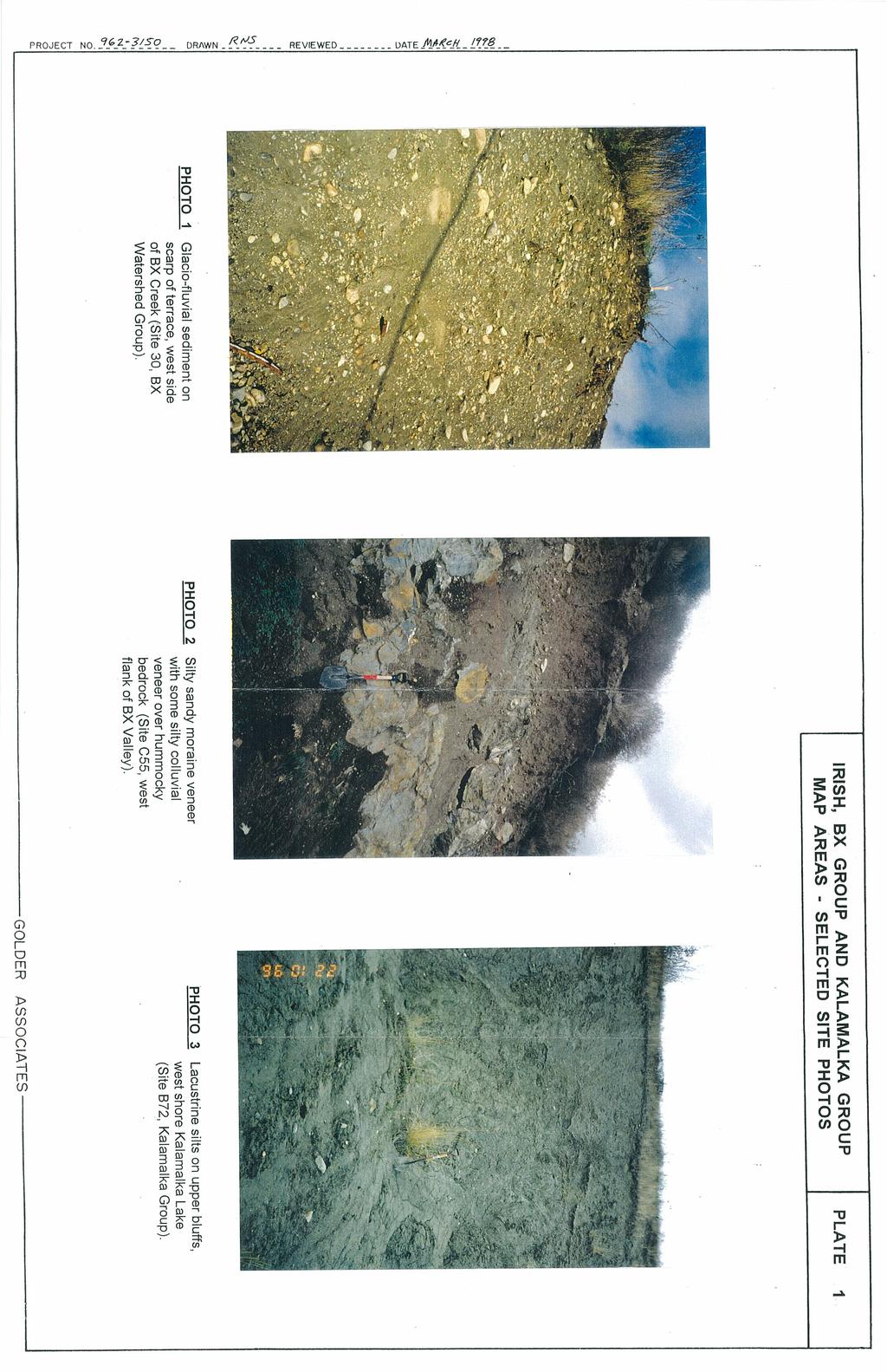
2 I I I Tolko Industries Ltd. Vernon District Terrain Mapping -1- March, INTRODUCTION This report accompanies a set of Terrain Maps IDl:d Derivative Maps produced as a result of detailed terrain stability mapping at terrain :survey intensity level (TSIL) C for 9 community watersheds in the Vernon Forest District. The maps pertain to the following study areas: Irish Creek watershed, (1030 ha) located 17 km northwest of Vernon, BX Group, including BX Creek, Attridge, Klim,i and Dixon watersheds, a 7580 ha cluster of watersheds extending from the municipal boundary to Silverstar Mountain 16 kin northeast of Vernon, Kalamalka Group, including Vernon Creek, Oyama, King Edward Lake, and Kalamalka watersheds (total of 40,020 ha). The locations of the study areas are shown on FigUres 1 and 2, attached. The work was conducted by Golder Associates Ltd. in association with KDW Geographic Solutions Ltd. on behalf of Tolko Industries Ltd. Utvington Division, and funded by FRBC. Terrain mapping and interpretations for slqpe stability, eros ion potential and sediment transfer potential were carried out accor~ing to provincial standards (see Section 2 - Methods). Terrain mapping was carried :out on 1994 series 1: scale colour air photos by a combination of air photo interpretation and field checking. I Original mapped photos and field notes have been retained by the Kamloops Region Ministry of Forests for archiving. This report outlines the mapping methodology followed and criteria developed for slope stability and other interpretations in the project area (Section 2). Comments regarding map reliability and project constraints are also included in Section 2. Section 3 contains a general overview of the study area. Sectiohs 4 and 5 summarize information about surficial materials and processes identified duting the course of mapping. The [mal section contains a brief discussion of the nature and extent of apparent terrain hazards present in the study area. 2.0 METHODS 2.1 Terrain Mapping Terrain mapping followed the standard British Oolumbia procedures for terrain classification (Howes and Kenk, 1997), mapping methods (RIC, 1995) and 5-class stability mapping (Forest Practices Code, 1995). I I Terrain mapping was conducted by Mr. Glen Rutherford, E.I.T. (south half of Kalamalka Group), Ms. Carrie-Lynn Brown, G.I.T. i(north half of Kalamalka Group Golder Associates
, with senior review and. roject management carried out by Mr. Greg Reid, P. Eng.")
3 Tolko Industries Ltd. Vernon District Terrain Mapping -2- March, and final mapping of BX Group) and Ms. Christinl Ouellet, P. Eng. (Irish Creek and pretyping of BX Group), with senior review and. roject management carried out by Mr. Greg Reid, P. Eng. Field checks were perfo med to verify preliminary mapping and, where necessary, revisions to the preliminary I ork. Initial fieldwork was carried out in October 1996 by the three mappers who spent a total of 30 crew days in the various map areas. Supplementary fieldwork was ~equested by the FRBC reviewers as part of the mandatory QA/QC process, which rer,ulted completion of an additional 9 crew days in the summer of 1997 in the BX and IKalamalka project areas. The work involved traversing representative polygons of the "Fious surficial materials and slopes within operable and potentially operable forest areas. In general, road access was adequate in many par~ of all of the project areas, with some exceptions, most notably parts of the Kal1; study area. The map areas were covered in the field by a combination of road quad, and foot traverses, with supplementary visual observations made during a b ief helicopter overflight of parts of the map areas. In general, the traverses were planned to provide representative coverage across all of the map areas while focusing ~n potentially operable regions with steeper slopes and areas of potential instability. Soil pits were dug on occasion where natural exposures, slide scars or tree-throw hollows kere not available for observation t Table 1: Airphotos Project Flight Line Photo numbers Photo Numbers Irish - Nl BCC94051 # Irish - N2 BCC94054 # BX- Nl BCC94048 # I BX-N2 BCC94043 # I BX- N3 BCC94043 # I BX-N4 BCC94048 # I BX- N5 BCC94043 # Kalamalka - N 1 not used I Kalamalka - N2 BCC94052 # Kalamalka - N3 BCC94049 # Kalamalka - N4 BCC94054 # Kalamalka - N5 BCC94089 # I Kalamalka - N6 BCC94099 # I Kalamalka - N7 BCC94052 # I BCC # Kalamalka - N8 BCC94049 # I Kalamalka - N9 BCC94053 # I Kalamalka - N 10 BCC94053 # I Kalamalka - NIl BCC94152 # I Kalamalka - N 12 BCC94058 # I Kalamalka - N 13 BCC94085 # Golder Associates

4
5
6
7
8
9

10

11
12
13
14
15
16
17
18
19
20
21

22

23
DETAILED TERRAIN MAPPING WITH INTERPRETATIONS FOR SLOPE STABILITY, EROSION POTENTIAL AND SEDIMENT TRANSFER. DILLARD CREEK FRBC Project # TO-96187
 ,, DETALED TERRAN MAPPNG WTH NTERPRETATONS FOR SLOPE STABLTY, EROSON POTENTAL AND SEDMENT TRANSFER DLLARD CREEK FRBC Project # TO-96187 Prepared by Blythe Killam, B.Sc., G..T. For Weyerhaeuser Canada Ltd.
MABEL LAKE RECONNAISSANCE TERRAIN STABILITY REPORT (T.S.I. LEVEL '0') to accompany
 to accompany") MABEL LAKE RECONNAISSANCE TERRAIN STABILITY REPORT (T.S.I. LEVEL '0') to accompany Terrain Stability Maps 82L.046; 047; 056;057;058;067; 068;077; 078; 088 Prepared for Riverside Forest Products Limited
MABEL LAKE RECONNAISSANCE TERRAIN STABILITY REPORT (T.S.I. LEVEL '0') to accompany Terrain Stability Maps 82L.046; 047; 056;057;058;067; 068;077; 078; 088 Prepared for Riverside Forest Products Limited
EBA Engineering ConsultCfnts Ltd.
 I EBA Engineering ConsultCfnts Ltd. DETAILED TERRAIN STABILITY MAPPIN WAPCREEK RIVERSIDE FOREST PRODUCTS Lnv.DTE ARl\1STRONG DIVISION EBA Project No. 0801-01-81217 #255, 1715 Dickson Avenue, Kelowna, British
SCOTCH, KWIKOIT and CORNING CREEKS DETAILED and RECONNAISSANCE TERRAIN STABILITY MAPPING SALMON ARM FOREST DISTRICT. P. oject No.
 SCOTCH, KWIKOIT and CORNING CREEKS DETAILED and RECONNAISSANCE TERRAIN STABILITY MAPPING SALMON ARM FOREST DISTRICT P. oject No. 0808-98-89822 DETAILED and RECONNAISSANCE TERRAIN MAPPING with INTERPRETATIONS
EBA Engineering Consultants Ltd.
 EBA Engineering Consultants Ltd. CHARCOAL CREEK DETAILED TERRAIN STABILITY MAPPING (TSIL C) SALMON ARM FOREST DISTRICT RIVERSIDE FOREST PRODllCTS LIMITED EBA Project No. 0801 99 81086 #255, 1715 Dickson
E8A Engineering Consultants Ltd.
 E8A Engineering Consultants Ltd. SILVER CREEK FIRE i DETAILED TERRAIN STABILITY MAPPING SALMON ARM FOREST DISTRICT! Project No. 0808-98-89969 #255,1715 Dickson Ave., Kelowna, B.C. CANADA V1Y9G6 - Telephone
FL A ADAMS LAKE. KAMLOOPS AND CLEARWATER FOREST DISTRl 'TS TSILD RECONNAISSANCE SLOPE T ABILITY FINALREPOR. Submitted
 FL A18693 - ADAMS LAKE I KAMLOOPS AND CLEARWATER FOREST DISTRl 'TS TSILD RECONNAISSANCE SLOPE T ABILITY FINALREPOR Submitted to INTERNATIONAL FOREST PRODUCTS LTD. Adams Lake Divisibn Terratech Consulting
THE DIGITAL TERRAIN MAP LIBRARY: AN EXPLORATIONIST S RESOURCE
 THE DIGITAL TERRAIN MAP LIBRARY: AN EXPLORATIONIST S RESOURCE By I.C.L. Webster, P.J. Desjardins and W.E. Kilby KEYWORDS: digital terrain maps, digital terrain stability maps, surficial geology, GIS, raster
Detailed Terrain Stability Mapping In the Ellis Creek Community Watershed and the Steward Creek Watershed, Penticton Forest District, BC
 Detailed Terrain Stability Mapping In the Ellis Creek Community Watershed and the Steward Creek Watershed, Penticton Forest District, BC Prepared for: Ministry of Forests Penticton Forest District Small
Re: Steep Slope Assessment for 2465 Waverly Drive, Blind Bay, BC; Legal Address: Lot 39, Section 18, Township 22, Range 10, Plan 25579, W6M, KDYD.
 OEL File 1563-1 May 30, 2017 Doug Wall PO Box 774 Salmon Arm, BC V1E 4N7 Re: Steep Slope Assessment for 2465 Waverly Drive, Blind Bay, BC; Legal Address: Lot 39, Section 18, Township 22, Range 10, Plan
TEXAS CREEK AR. Prepared by. Jennifer Shypitka, B.Sc, GJ.T. For. B.C. Ministry of For sts Lillooet Forest Dist ict. January 1996
 1 1 TEXAS CREEK AR DETALED TERRAN M PPNG WTH EVALUATONS FOR SL PE STABLTY AND EROSON POTE TAL l Prepared by ennifer Shypitka, B.Sc, G.T. For B.C. Ministry of For sts Lillooet Forest Dist ict anuary 1996.M.
SALMON RIVER TRI~UT ARIES
 SALMON RVER TR~UT ARES TERRAN STABLTY REPORT {T.5.1. LEVEL 'C'}; to accompany : Terrain and Terrain Stability Maps 82L.053, 82L.054, 82L.063, 82L.06~t and 82L.073 Prepared for Riverside Forest Products
1.0 INSPECTION ANNUAL INSPECTION, JUNE 29, 2011 CARMACKS COPPER PROJECT, CARMACKS, YUKON. Dear Mr. West-Sells,
 Doc. No. 162 Rev. 0 Mr. Paul West-Sells President & Chief Operating Officer Western Copper Corporation 2060-1111 West Georgia Street Vancouver, BC V6E 4M3 ANNUAL INSPECTION, JUNE 29, 2011 CARMACKS COPPER
This report was prepared by Klohn Crippen Consultants Ltd. for Alberta Transportation Central Region under Contract No. CE053/2000.
 Alberta Transportation Central Region #401, 4902 51 Street Red Deer, Alberta T4N 6K8 June 7, 2002 Mr. Melvin Mayfield, P.Eng. Project Engineer Dear Mr. Mayfield: Central Region Landslide Assessment Site
- LONGITUDE : 128'06 'W
 COMINCO LTD. WESTERN DISTRICT MARCH 1977 SOIL GEOCHEMICAL SURVEY SAND 1 and SAND 2 CLAIMS HIDDEN VALLEY AREA LIARD MINING DIVISION LATITUDE : 59'03' - LONGITUDE : 128'06 'W JUNE 20/76-JULY 12/76 REPORT
EBA Engineering Consultants Ltd. Creating and Delivering Better Solutions
 EBA Engineering Consultants Ltd. Creating and Delivering Better Solutions ENHANCING THE CAPABILITY OF ECOSYSTEM MAPPING TO SUPPORT ADAPTIVE FOREST MANAGEMENT Prepared by: EBA ENGINEERING CONSULTANTS LTD.
MINERAL MOUNTAIN RESOURCES LTD. MMV.TSX-V
 MINERAL MOUNTAIN RESOURCES LTD. 201-1416 West 8 th Avenue Vancouver, B.C. V6H 1E1 T: 604-714-0111 F: 604-714-1119 MMV.TSX-V NEWS RELEASE March 3, 2011 No. 2011-04 MINERAL MOUNTAIN DRILLS 3.17 g/t OVER
Licensed Science Officer Benchmark
 POSITION EVALUATION RATIONALE POSITION TITLE Senior Project Geologist MINISTRY AND DIVISION Energy, Mines and Petroleum Resources: Geological Division BRANCH AND SECTION Mineral Resources UNIT OR PROGRAM
..!I AXE CLAIMS ON THE. for RICHCORE EXPLORATIONS LTO. GREENWOOD MINING DIVISION BRITISH COLUMBIA. Latitude 49O 30"; Longitude 118' 30'W NTS 82E/9W
 ON THE AXE CLAIMS for RICHCORE EXPLORATIONS LTO. GREENWOOD MINING DIVISION BRITISH COLUMBIA Latitude 49O 30"; Longitude 118' 30'W NTS 82E/9W... -... ~ i.,...._.'..!i Vancouver, B.C. September, 1980 P.
The subject paper is being submitted for approval for publication in the annual volume entitled Geological Survey Research.
 Water Resources Division 345 Middlefield Road Menlo Park, California January 12, 1965 Memorandum To: Mr. Frank E. Clark, Chief, General Hydrology Branch Thru: Area Hydrologist PCA From: Valmore C. LaMarche
February 18, 2003 File: NORTH CENTRAL REGION LANDSLIDE ASSESSMENT HWY 43:16 WHITECOURT EAST HILL (NC1) 2002 ANNUAL INSPECTION REPORT
 2002 ANNUAL INSPECTION REPORT") February 18, 2003 File: 15-76-11 Alberta Transportation Room 223, Provincial Building 4709 44 Avenue Stony Plain, Alberta T7Z 1N4 Attention: Mr. Rob Lonson, P.Eng. NORTH CENTRAL REGION LANDSLIDE ASSESSMENT
February 18, 2003 File: 15-76-11 Alberta Transportation Room 223, Provincial Building 4709 44 Avenue Stony Plain, Alberta T7Z 1N4 Attention: Mr. Rob Lonson, P.Eng. NORTH CENTRAL REGION LANDSLIDE ASSESSMENT
P. Beaudry and Associates Ltd. Integrated Watershed Management
 P. Beaudry and Associates Ltd. Survey of Small and Large Sediment Sources Within the Watershed Dawson Forest District Prepared for: Chetwynd Forest Industries A Division of West Fraser Mills Ltd. P.O.
1 PROJECT BACKGROUND. August 14, Alberta Transportation Central Region #401, Street Red Deer, Alberta T4N 6K8
 August 14, 2013 Alberta Transportation Central Region #401, 4902 51 Street Red Deer, Alberta T4N 6K8 Mr. Dennis Grace, P.Eng. Construction Engineer Dear Mr. Grace: Central Region Geohazard Assessment 2013
NTS 93L/9W GEOCHEMICAL AND GEOPHYSICAL REPORT MONA CLAIM OMINICA MINING DIVISION. Lati tude 54036'N; Longitude 'W
 GEOCHEMICAL AND GEOPHYSICAL REPORT ON MONA CLAIM OMINICA MINING DIVISION Lati tude 54036'N; Longitude 126018'W NTS 93L/9W April 1981 Paul Plicka Consulting Geologist LOCATION MAP INTRODUCTION TABLE OF
Archaeological Predictive Modeling within the context of Paleo-river Terraces in the City of Prince George
 Archaeological Predictive Modeling within the context of Paleo-river Terraces in the City of Prince George Background The documented pre-contact archaeological record of the Interior Plateau of B.C. is
APPLIED FLUVIAL GEOMORPHOLOGY
 APPLIED FLUVIAL GEOMORPHOLOGY Where have we come from, where do we go? Roger TJ Phillips Mariëtte Pushkar and Peter Ashmore Value of Geomorphologists in River Management Start with Historical Geology and
THE NEW DNR LANDSLIDE HAZARDS PROGRAM
 THE NEW DNR LANDSLIDE HAZARDS PROGRAM Kara Jacobacci, G.I.T. Landslide Hazards Program Washington Geological Survey Washington Department of Natural Resources LEGISLATIVE FUNDING 2015 session DNR requested
PEACE REGION (PEACE RIVER- HIGH LEVEL AREA) GEOHAZARD ASSESSMENT CALL-OUT PH56: EMBANKMENT FAILURE ON HWY 35:08 SOUTHWEST OF MEIKLE RIVER CROSSING
 GEOHAZARD ASSESSMENT CALL-OUT PH56: EMBANKMENT FAILURE ON HWY 35:08 SOUTHWEST OF MEIKLE RIVER CROSSING") ( (/)...,. - (D
( (/)...,. - (D
via via CCTA File /6 Train Avenue West and 70 Yonge Street South, Springwater Natural Hazard Study
 January 16, 217 via via email (vsimpson@ipsconsulting.com) CCTA File 416428 Vanessa Simpson, B.ID, M.PL. Junior Planner/ Planning Technician Innovative Planning Solutions 1 Dunlop Street East, Suite 21
September 17, OGC
 OGC OIL A N D GAS C O M M ISSIO N September 17, 2004 9000-2855-32640-02 OGC - 04269 Natalie Sanders Subsurface Regulatory Application Coordinator Shell Canada Limited 400-4th Avenue SW P.O. Box 100 Station
ASSESSMENT REPORT ON THE PEAVINE PROJECT. DGW & Associates # Alberni Street, Vancouver, British Columbia, V6E 4V2
 ASSESSMENT REPORT ON THE PEAVINE PROJECT KAMLOOPS MINING DIVISION BRITISH COLUMBIA NTS 082M 12 Latitude 51 36' 19.0"North -- Longitude --119 47' 27.0"West UTM Zone 11, NAD 83 5720827N 306744E Prepared
Snow depths and solar radiation before and after partial logging at the Mt. Tom Adaptive Management Trial
 Snow depths and solar radiation before and after partial logging at the Mt. Tom Adaptive Management Trial File Report by Pat Teti, M.Sc. Research Hydrologist B.C. Ministry of Forests and Range Williams
Mark Hawley, Piteau Associates Engineering Ltd. John Cunning, Golder Associates Ltd.
 Introducing: GUIDELINES FOR MINE WASTE DUMP AND STOCKPILE DESIGN Editors: Mark Hawley, Piteau Associates Engineering Ltd. John Cunning, Golder Associates Ltd. 8 November 2017 Sponsorship 8 November 2017
Watershed Overview. 2.1 Purpose
 Watershed Overview 2.1 Purpose The purpose of this SHIM module is to develop an interim base map on which existing information can be presented, prior to initiating field mapping. This base map should
Lat. 52' 43' N Long ' W
 &A exploration ltd MINING ENGINEERING GEOLOGY- GEOPHYSICS 4570 HOSKINS ROAD, NORTH VANCOUVER, 6. C. TELEPHONE (804) 985,7921 V7K 2R1 GEOLOGICAL AND GEOCHEMICAL REPORT on the BLUE CLAIMS Cariboo Mining
patersongroup Mineral Aggregate Assessment 3119 Carp Road Ottawa, Ontario Prepared For Mr. Greg LeBlanc March 7, 2014 Report: PH2223-REP.
 Geotechnical Engineering Environmental Engineering group Hydrogeology Geological Engineering Archaeological Studies Materials Testing 3119 Carp Road Prepared For Mr. Greg LeBlanc March 7, 2014 Paterson
APPENDIX 1. Geotechnical Information and Analysis. Pacific Aggregates Inc. and Pacific Clay Products July 13, 2011 RP112 Reclamation Plan
 Pacific Aggregates Inc. and Pacific Clay Products July 13, 2011 RP112 Reclamation Plan APPENDIX 1 Geotechnical Information and Analysis PA02_RP112-RecPlan-Resub_FNL.docx SESPE Consulting, Inc. June 27,
August 14, James Bolton 312 Perry Lane Lovingston, VA
 August 14, 2017 James Bolton 312 Perry Lane Lovingston, VA 22949 jrbolton035@gmail.com Department of Environmental Quality Office of Wetlands & Stream Protection P.O. Box 1105 Richmond, VA 23218 comment-acp@deq.virginia.gov
1. PROJECT BACKGROUND. July 18, Alberta Infrastructure & Transportation Central Region #401, Street Red Deer, Alberta T4N 6K8
 July 18, 2005 Alberta Infrastructure & Transportation Central Region #401, 4902 51 Street Red Deer, Alberta T4N 6K8 Mr. Alain Momedi, P.Eng. Project Engineer Dear Mr. Momedi: H11:04 km 11.1 Erosion along
NOTICE OF PUBLIC TENDER
 Ministry of Natural Gas Development UPSTREAM DEVELOPMENT DIVISION NOTICE OF PUBLIC TENDER COMPETITION FOR THE RIGHT TO EXPLORE AND DEVELOP CROWN PETROLEUM AND NATURAL GAS RESOURCES JULY 16, 2014 Pursuant
Suitability Analysis on Second Home Areas Selection in Smithers British Columbia
 GEOG 613 Term Project Suitability Analysis on Second Home Areas Selection in Smithers British Columbia Zhengzhe He November 2005 Abstract Introduction / background Data Source Data Manipulation Spatial
2010 Fish Passage Culvert Inspection (FPCI) Fish Presence/Absence Mapping Progress Report (Phases 1 through 3)
 Fish Presence/Absence Mapping Progress Report (Phases 1 through 3)") 2010 Fish Passage Culvert Inspection (FPCI) Fish Presence/Absence Mapping Progress Report (Phases 1 through 3) Prepared for: Kamloops Timber Supply Area 11 (TSA 11) Contributors: Report prepared by: Jenine
2010 Fish Passage Culvert Inspection (FPCI) Fish Presence/Absence Mapping Progress Report (Phases 1 through 3) Prepared for: Kamloops Timber Supply Area 11 (TSA 11) Contributors: Report prepared by: Jenine
MINISTRY OF FORESTS, LANDS AND NATURAL RESOURCE OPERATIONS, POST-WILDFIRE RISK ANALYSIS PRELIMINARY REPORT
 MINISTRY OF FORESTS, ANDS AND NATURA RESOURCE OPERATIONS, POST-WIDFIRE RISK ANAYSIS PREIMINARY REPORT NOTE: The results given on this form are preliminary in nature and are intended to be a warning of
Prospecting Report on the Dynasty Jade Placer Dorthy Creek Claims
 Prospecting Report on the Dynasty Jade Placer Dorthy Creek Claims Claims 550004, 541288, 547670 Mining Division - Liard NTS or BCGS location 104J080 Latitude and longitude of geographic centre of work
The Role of Mapping, GPS, and GIS in Trail Design and Construction
 The Role of Mapping, GPS, and GIS in Trail Design and Construction How do we normally think about MAPS and TRAILS? Idea of map as final product Trail maps Kiosk / trailhead maps Survey plat Map as Product
PROSPECTING REPORT THE WALLACE CLAIM OMENICA MINING DIVISION. 54" x6" 3.d d. for. Reako Exlorat ions Ltd. Wallace Rev. C.G.
 PROSPECTING REPORT ON THE WALLACE CLAIM OMENICA MINING DIVISION 54"44 14 1x6" 3.d d by David A. Howard P.Eng. for Reako Exlorat ions Ltd. Claim Locat ion Wallace Rev. C.G. #1560 Dome Mountain Area 9 3
Prospecting Report on the Dynasty Jade Claims
 Prospecting Report on the Dynasty Jade Claims Claims 519762, 520237, 520336 Mining Division - Liard NTS or BCGS location 104J080 Latitude and longitude of geographic centre of work 58.78 N 130.08 W Owner
PHASE 1 STUDIES UPDATE EROSION WORKING GROUP
 PHASE 1 STUDIES UPDATE EROSION WORKING GROUP Presented By MICHAEL WOLFF, PG Erosion Study Area Manager West Valley Demonstration Project Quarterly Public Meeting February 24, 2016 OUTLINE Study 1 Terrain
September 3, 2009 File: NORTH CENTRAL REGION GEOHAZARD ASSESSMENT HWY 40:28 NORTH OF CADOMIN (NC50) 2009 ANNUAL INSPECTION REPORT
 2009 ANNUAL INSPECTION REPORT") GEOTECHNICAL ENVIRONMENTAL MATERIALS September 3, 2009 File: 15-16-226 Alberta Transportation 2 nd Floor, Provincial Building 111 54 Street Edson, Alberta T7E 1T2 Attention: Mr. Cliff Corner NORTH CENTRAL
GEOTECHNICAL ENVIRONMENTAL MATERIALS September 3, 2009 File: 15-16-226 Alberta Transportation 2 nd Floor, Provincial Building 111 54 Street Edson, Alberta T7E 1T2 Attention: Mr. Cliff Corner NORTH CENTRAL
Groundwater Investigation SOUTHGATE GRAVEL PIT Part of Lot 15, Concession 15 (formerly Township of Proton), Township of Southgate.
, Township of Southgate.") Groundwater Investigation SOUTHGATE GRAVEL PIT Part of Lot 15, Concession 15 (formerly Township of Proton), Township of Southgate County of Grey October, 2014 Prepared for: Drysdale Aggregate Consulting
Groundwater Investigation SOUTHGATE GRAVEL PIT Part of Lot 15, Concession 15 (formerly Township of Proton), Township of Southgate County of Grey October, 2014 Prepared for: Drysdale Aggregate Consulting
MISSION CREEK WATERSHED (2002 Report Year 4)
") Stream Channel Monitoring Program for the MISSION CREEK WATERSHED (2002 Report Year 4) (Penticton Forest District) Prepared for RIVERSIDE FOREST PRODUCTS LTD. Prepared by DOBSON ENGINEERING LTD. #4, 1960
Stream Channel Monitoring Program for the MISSION CREEK WATERSHED (2002 Report Year 4) (Penticton Forest District) Prepared for RIVERSIDE FOREST PRODUCTS LTD. Prepared by DOBSON ENGINEERING LTD. #4, 1960
MRD-160 METADATA DETAIL PAGE
 MRD-160 METADATA DETAIL PAGE The following represents the Basic description of an information holding. To obtain more information about this holding, see the section named Contacts. GENERAL INFORMATION
3 SHORELINE CLASSIFICATION METHODOLOGY
 3 SHORELINE CLASSIFICATION METHODOLOGY Introduction The ESI scale, as described in Section 2, categorizes coastal habitats in terms of their susceptibility to spilled oil, taking into consideration a number
January 16, Re: Soo Line Dump Site 2018 Annual Soil Cover Inspection. Dear Mr. Nichols:
 January 16, 2019 Mr. Andrew Nichols Minnesota Pollution Control Agency Voluntary Investigation and Cleanup Program 520 Lafayette Road Saint Paul, Minnesota 55155 Re: Soo Line Dump Site 2018 Annual Soil
Manitoba s Elevation (LiDAR) & Imagery Datasets. Acquisition Plans & Opportunities for Collaboration
 & Imagery Datasets. Acquisition Plans & Opportunities for Collaboration") Manitoba s Elevation (LiDAR) & Imagery Datasets Acquisition Plans & Opportunities for Collaboration Manitoba Planning Conference May 2017 Presentation Outline Manitoba s Elevation (LiDAR) and Imagery Datasets
Manitoba s Elevation (LiDAR) & Imagery Datasets Acquisition Plans & Opportunities for Collaboration Manitoba Planning Conference May 2017 Presentation Outline Manitoba s Elevation (LiDAR) and Imagery Datasets
MEMORANDUM. wa.tsr..-z.n~.e.s-t.i~at.i.o.ns... Branch... Mr. Webster contends that prior to excavation of the gravel
 TO... J. C. Foweraker 2... Head Gr o w a t er S e c t i on... Hyar....og~~~.~.~vis.ion... wa.tsr..-z.n~.e.s-t.i~at.i.o.ns... Branch... eernment OF BRITISH COLUMBIA MEMORANDUM II 0 PROM A. P. Kohut, Geological
Table 1 - Infiltration Rates
 Stantec Consulting Ltd. 100-300 Hagey Boulevard, Waterloo ON N2L 0A4 November 14, 2017 File: 161413228/10 Attention: Mr. Michael Witmer, BES, MPA, MCIP, RPP City of Guelph 1 Carden Street Guelph ON N1H
Canadian Technical Landslide Guidelines and Best Practices for Landslide Professionals
 Canadian Technical Landslide Guidelines and Best Practices for Landslide Professionals AEG Professional Forum on Landslides Seattle, WA; February 2015 Doug VanDine, PEng/PGeo (BC) VanDine Geological Engineering
Appendix C. Questionnaire Summary of Responses Geographic Information Systems
 Appendix C Questionnaire Summary of Responses Geographic Information Systems 1. Is your agency using or planning use of GIS for: a. general mapping (e.g. highway routes, political boundaries, etc.) b.
TRENCHING AT LAS DOLORES EXTENDS STRIKE LENGTH TO OVER 1,000 METRES, INTERSECTING
 January 31, 2018 NEWS RELEASE - #18-03 TSX- V: GRR Suite 501-595 Howe Street Vancouver, BC V6C 2T5 Tel: (604) 685-4655 Fax: (604) 685-4675 Toll Free: 1-888-685-4655 TRENCHING AT LAS DOLORES EXTENDS STRIKE
August 10, 2007 File:
 August 10, 2007 File: 15-85-72 Alberta Infrastructure and Transportation Room 301, Provincial Building 9621-96 Avenue Peace River, AB T8S 1T4 Attention: Mr. Ed Szmata PEACE REGION (PEACE HIGH LEVEL AREA)
Ronin Placer Ground-penetrating Radar Survey Report
 Ronin Placer Ground-penetrating Radar Survey Report Tenures: 837095, 837097 Mining Division: Greenwood NTS Location: 082E/03 Geographic Center Coordinates: UTM Zone 11, E 345340, N 5438730 Claims Owner:
Analysis of Road Sediment Accumulation to Monumental Creek using the GRAIP Method
 Analysis of Road Sediment Accumulation to Monumental Creek using the GRAIP Method Introduction (from http://www.neng.usu.edu/cee/faculty/dtarb/graip/#over): The Geomorphologic Road Analysis and Inventory
GEOLOGICAL MAPPING REPORT ON THE ASH MINERAL CLAIM OSOYOOS MINING DIVISION ASHNOLA RIVER MAP SHEET NTS M092,H019 MCBRIDE CREEK AREA, ASHNOLA RIVER,
 GEOLOGICAL MAPPING REPORT ON THE ASH MINERAL CLAIM OSOYOOS MINING DIVISION ASHNOLA RIVER MAP SHEET NTS M092,H019 LATITUDE 49 o O6, LONGITUDE 120 o 22 MCBRIDE CREEK AREA, ASHNOLA RIVER, KEREMEOS, B.C. CANADA
Quality Assurance Project Plan (QAPP) - Vegetation Survey of Huron Creek Houghton, MI
 - Vegetation Survey of Huron Creek Houghton, MI") Quality Assurance Project Plan (QAPP) - Vegetation Survey of Huron Creek Houghton, MI Prepared By: Linda D. Kersten, Dr. Alex S. Mayer Michigan Technological University, Center for Water & Society Prepared
Quality Assurance Project Plan (QAPP) - Vegetation Survey of Huron Creek Houghton, MI Prepared By: Linda D. Kersten, Dr. Alex S. Mayer Michigan Technological University, Center for Water & Society Prepared
DROUGHT RISK EVALUATION USING REMOTE SENSING AND GIS : A CASE STUDY IN LOP BURI PROVINCE
 DROUGHT RISK EVALUATION USING REMOTE SENSING AND GIS : A CASE STUDY IN LOP BURI PROVINCE K. Prathumchai, Kiyoshi Honda, Kaew Nualchawee Asian Centre for Research on Remote Sensing STAR Program, Asian Institute
Vergo Placer Claims Ground-penetrating Radar Survey Report
 Vergo Placer Claims Ground-penetrating Radar Survey Report Tenures: 583789, 586819 Mining Division: Greenwood NTS Location: 082E/03 Geographic Center Coordinates: UTM Zone 11, E 346013, N 5440152 Claims
Assignment 1. Measuring River Characteristics- Vernon Creek. Applied Fluvial Geomorphology Field Techniques EESc 435
 Assignment 1 Measuring River Characteristics- Vernon Creek Applied Fluvial Geomorphology Field Techniques EESc 435 Amanda Jardine 30100093 Jaime McDonald 14177083 Erica Massey 50870088 April 28, 2012 Introduction
Karst Inventory Standards and Vulnerability Assessment Procedures for British Columbia
 and Vulnerability Assessment Procedures for British Columbia Prepared by The Karst Task Force for the Resources Inventory Committee January 2001 Version 1.0 2001 The Province of British Columbia Published
HYDROLOGY AND HYDRAULICS MUSKEG RIVER BRIDGE
 PUBLIC WORKS CANADA HYDROLOGY AND HYDRAULICS MUSKEG RIVER BRIDGE KILOMETRE 207.9, LIARD HIGKWAY December 1978 I I f I I I I # Bolter Parish Trimble Ltd. ONLIULTINO Public Works, Canada, 9925-109 Street,
POST WILDFIRE HAZARD ASSESSMENTS
 Provincial Emergency Program POST WILDFIRE HAZARD ASSESSMENTS Springer and Sitkum Creek Fires M09468A01 March 21, 2008 PROVINCIAL EMERGENCY PROGRAM Emergency Management British Columbia 455 Boleskine Road
BIODIVERSITY CONSERVATION HABITAT ANALYSIS
 BIODIVERSITY CONSERVATION HABITAT ANALYSIS A GIS Comparison of Greater Vancouver Regional Habitat Mapping with Township of Langley Local Habitat Mapping Preface This report was made possible through the
PHYSICAL WORK REPORT. the BAY CLAIMS. Omineca Mining Division Smithers, British Columbia N.T.S. 93E 13E/W
 PHYSICAL WORK REPORT the BAY CLAIMS Omineca Mining Division Smithers, British Columbia a N.T.S. 93E 13E/W LATITUDE: 53 57 00 N I LONGITUDE: 127 45 OO W for Home Ventures Ltd. 1201-675 West Hastings Street
December 11, 2006 File:
 December 11, 2006 File: 15-85-38 Alberta Infrastructure and Transportation Room 301, Provincial Building 9621-96 Avenue Peace River, Alberta T8S 1T4 Attention: Mr. Ed Szmata PEACE REGION (SWAN HILLS AREA)
Licensed Science Officer Benchmark
 POSITION EVALUATION RATIONALE POSITION TITLE MINISTRY AND DIVISION Energy, Mines and Petroleum Resources: Geology Division BRANCH AND SECTION Mineral Resources Branch, Applied Geology Section UNIT OR PROGRAM
Large Scale Mapping Policy for the Province of Nova Scotia
 Large Scale Mapping Policy for the Province of Nova Scotia December, 2005 Version 1.0 TABLE OF CONTENTS PAGE BACKGROUND...3 POLICY...5 Policy 1.0 Large Scale Mapping Program...5 Policy 2.0 Service Offering...5
Our File: 92 F/1, 92 F/8. Numerous licenced springs occur north of the B.C. Hydro right-of-way on. Water Management Branch
 J.C. Foweraker, Head Groundwater Section Water Management Branch Date: May 23, 1986 Our File: 92 F/1, 92 F/8 Re: Groundwater - D.L. 117. Nanoose District As requested by Mr. B. Hollingshead, Regional Water
Edward R. Sajecki Commissioner of Planning and Building. Conservation Authority Regulations and Mapping
 Corporate Report Clerk s Files Originator s Files EC.19.CON DATE: TO: FROM: SUBJECT: Chair and Members of Planning and Development Committee Meeting Date: April 3, 2006 Edward R. Sajecki Commissioner of
Little Blackfoot TPA 2009 Sediment and Habitat Assessment QAQC Review March 9, 2010
 Little Blackfoot TPA 2009 Sediment and Habitat Assessment QAQC Review March 9, 2010 1.0 PROJECT OVERVIEW Sediment and habitat monitoring in the Little Blackfoot TPA was conducted in July of 2009 as outlined
Roy Pyle March 24, 2017 Chief Facilities Planner Contra Costa Community College District 500 North Court Street Martinez, CA 94533
 State of California Natural Resources Agency Edmund G. Brown Jr., Governor Department of Conservation John G. Parrish, Ph.D., State Geologist California Geological Survey 801 K Street MS 12-31 Sacramento,
Chapter Five. Synopsis
 Chapter Five Synopsis .0 Proposed Level Assessments. Prioritization of Level Assessments. Recommended Level P Locations.3 Level RAPP Locations 5 & Mosley Creek & RA.0 Proposed Level Assessments Based on
GEOPHYSICAL DATA SET (GDS) 1084B METADATA
 1084B METADATA") GEOPHYSICAL DATA SET (GDS) 1084B METADATA GENERAL INFORMATION Official Name of the Data Set or Information Holding: Ontario Airborne Geophysical Surveys, Magnetic Gradiometer and Gamma-Ray Spectrometric
GEOPHYSICAL DATA SET (GDS) 1084B METADATA GENERAL INFORMATION Official Name of the Data Set or Information Holding: Ontario Airborne Geophysical Surveys, Magnetic Gradiometer and Gamma-Ray Spectrometric
GEOCSZNICAL - SURVEY. ICAMLOOPS Kl.D. 2'' 6;kr. HY "'f. Alfred R. Allen,P.Eng. 1 NO.%=...,... 6"- 'I.
 t i.i GEOCSZNICAL - SURVEY i p' ICAMLOOPS Kl.D. 2'' 6;kr HY 50-64 +."'f 121-51 NE 5-10-70 : 19-10-70 Alfred R. Allen,P.Eng. I) ' 1 6"- 'I. 1 NO.%=...,..... Q.C. EXPLORATIONS LTD. 2Cl- 535 Kowe Street Vancouver
Earth Sciences Report Alberta Kimberlite-Indicator Mineral Geochemical Compilation
 Earth Sciences Report 2001-20 Alberta Kimberlite-Indicator Mineral Geochemical Compilation Alberta Kimberlite-Indicator Mineral Geochemical Compilation D.R. Eccles 1, M. Dufresne 2, D. Copeland 2, W. Csanyi
May 22, Mr. Tim Tyler TRWME Properties, LLC 240 Hwy. 65 N Conway, AR RE: Royal Oaks Vista Subdivision Site. Dear Mr.
 May 22, 2008 Mr. Tim Tyler TRWME Properties, LLC 240 Hwy. 65 N Conway, AR 72032 RE: Royal Oaks Vista Subdivision Site AFIN: 12-00272 NPDES Permit No.: ARR150472 Dear Mr. Tyler: On March 26, 2008, I performed
MEMORANDUM. REVISED Options for Landslide Regulations: Setbacks and Slope Height
 Snohomish County Council Office MS #609 3000 Rockefeller Avenue Everett, WA 98201 (425) 388-3494 MEMORANDUM DATE: May 2, 2014 TO: FROM: RE: Councilmembers Will Hall, Council Staff REVISED Options for Landslide
Serengeti Resources Inc GEOCHEMICAL REPORT ON THE SHADOW PROPERTY a.
 Serengeti Resources Inc. 2004 GEOCHEMICAL REPORT ON THE SHADOW PROPERTY a. Located in the Johanson Lake Area Omenica Mining Division NTS 94D/9 6 degrees and 32 minutes North Latitude 126 degrees and 2
Date of Report: EPA agreement number: Center Name and Institution of Ctr. Director: Identifier used by Center for Project: Title of Project:
 Date of Report: March 31, 2003 EPA agreement number: R829515C003 Center Name and Institution of Ctr. Director: Rocky Mountain Regional Hazardous Substance Research Center, Colorado State University, Fort
IDM Mining s Underground Drilling Intersects g/t Au and g/t Ag over 6.80 Meters True Width at the Red Mountain Gold Project
 IDM Mining s Underground Drilling Intersects 18.70 g/t Au and 66.85 g/t Ag over 6.80 Meters True Width at the Red Mountain Gold Project November 22 nd, 2016, Vancouver, BC IDM Mining Ltd. (TSX.V:IDM) (
51 46'N Latitude, 119'44'1;!
 COMI)!CO LTD. EXPLORATION NTS: 82 1'1/13E GEOCHEKICAL ASSESSMENT REPORT ON THE SI 1 MINERAL CLAIM in the Kamloops Mining Division 51 46'N Latitude, 119'44'1;! Longitude Work Period: June 25, 1979 - July
CanAlaska Uranium Details Extensive Rare Earth Mineralization at NE Wollaston
 FOR IMMEDIATE RELEASE NEWS RELEASE CanAlaska Uranium Details Extensive Rare Earth Mineralization at NE Wollaston Vancouver, Canada, October 20 th, 2009 CanAlaska Uranium Ltd. (CVV TSX.V) (the Company )
Valley-Fill Sandstones in the Kootenai Formation on the Crow Indian Reservation, South-Central Montana
 DE-FG22-96BC14996--08 Valley-Fill Sandstones in the Kootenai Formation on the Crow Indian Reservation, South-Central Montana Quarterly Report April 1 - June 30, 1998 By David A. Lopez Work Performed Under
Required Documents. Title: Number: AEP Administration 2017 No. 1. Provincial Wetlands and Water Boundaries Section. Effective Date: September 1, 2017
 Title: Number: Program Name: Provincial Wetlands and Water Boundaries Section Effective Date: September 1, 2017 This document was updated on: August 25, 2017 The Provincial Wetlands and Water Boundaries
January 17, 2008 File:
 January 17, 2008 File: 15-85-73 Alberta Infrastructure and Transportation Room 301, Provincial Building 9621-96 Avenue Peace River, Alberta T8S 1T4 Attention: Mr. Ed Szmata PEACE REGION (SWAN HILLS AREA)
Canadian Gold Miner Grab Sample Returns 29.5 Grams per tonne Gold from South Kirkland Project
 Canadian Gold Miner Grab Sample Returns 29.5 Grams per tonne Gold from South Kirkland Project Sudbury, July 27, 2017 Canadian Gold Miner Corp ( CGM, the Company) and Transition Metals Corp. (XTM TSX.V,
Ronin and Dayton Placer Ground-penetrating Radar Survey Report
 Ronin and Dayton Placer Ground-penetrating Radar Survey Report Tenures: 837095, 837097, 889865, 890187 Mining Division: Greenwood NTS Location: 082E/03 Geographic Center Coordinates: UTM Zone 11, E 345340,
USING HYPERSPECTRAL IMAGERY
 USING HYPERSPECTRAL IMAGERY AND LIDAR DATA TO DETECT PLANT INVASIONS 2016 ESRI CANADA SCHOLARSHIP APPLICATION CURTIS CHANCE M.SC. CANDIDATE FACULTY OF FORESTRY UNIVERSITY OF BRITISH COLUMBIA CURTIS.CHANCE@ALUMNI.UBC.CA
Exxon Valdez Oil Spill Restoration Project Annual Report
 Exxon Valdez Oil Spill Restoration Project Annual Report Ecology and Demographics of Pacific Sand Lance, Ammodytes hexapterus Pallas, in Lower Cook Inlet, Alaska Restoration Project 99306 Final Report
Clyde River Landslide
 Clyde River Landslide Department of Geology, Perkins Hall, University of Vermont, Burlington, VT 05405 Abstract: This paper investigates a landslide on the Clyde River in Newport, Vermont. The landslide
Placer Potential Map. Dawson L and U se P lan. Jeffrey Bond. Yukon Geological Survey
 Placer Potential Map Dawson L and U se P lan By Jeffrey Bond Yukon Geological Survey Dawson Land Use Plan Placer Potential Map 1.0 Introduction Placer mining has been an important economic driver within