Using High-Resolution Airphotos for Assessing Landscape Change. Torre Jorgenson
|
|
|
- Dana Brown
- 5 years ago
- Views:
Transcription
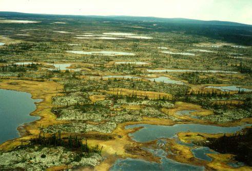


1 Using High-Resolution Airphotos for Assessing Landscape Change Torre Jorgenson

2 It s All a Matter of Scale Landsat TM 28-m pixel

3 Ikonos Fused 1-m pixel

4 Digital Camera 0.2-m pixel
5
6
7 Examples of Landscape Change Inventory (1 time) vs Monitoring (repeat) Coastal Erosion Waterbody changes Floodplain Dynamics Thermokarst Vegetation Disturbance and recovery

8 Coastal Changes Geomorphic Change Areal Extent (% area) % overall change Dune Changes Tidal uplift changes Shoreline- Beach Changes Channel changes Overwash succession


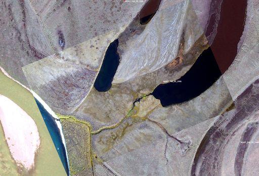
9 Waterbody Changes
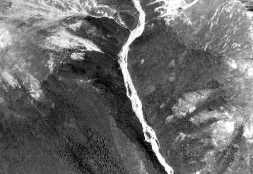
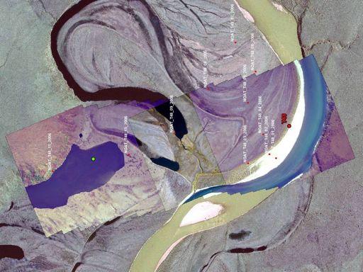
10 Nechelik Need SWAN photos SCALE IN MILES N Areas of Erosion and Deposition Eroded Riverbed/Sandbar Area (%) 1.3 Channel Riverbed/Sandbar Deposition 2.6 Channel Unchanged Riverbed/Sandbar Thaw Basin Drainage/Deposition East Other Eroded Terrain 1.0 Colville River Unchanged Terrain Lake-level Change Unchanged Water Proposed Project In-field Facilities Pipelines Nuiqsut Landscape Change from 1955 to 1992, Central Colville River Delta


11 Floodplain Dynamics

 in 2001 not evident in 1982 Area increased from 1.")
12 1982 Thermokarst Pits m 2001 Thermokarst Pits m pixels 93% (n=202) of easily visible large pits (>9 m 2 ) in 2001 not evident in 1982 Area increased from 1.0% in 1982 to 5.4% in m pixels

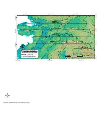
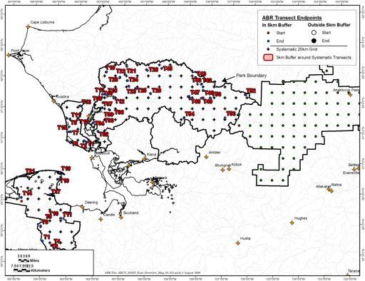
13 1945 Time Series: Beaufort Coastal Plain Drying location Wetting location
14 1982 Pond shifts Pond develops
15 2001 Ponds drains Pond develops Pond drains
16 1982
17 2001


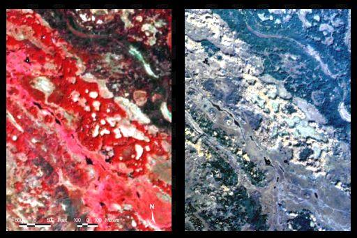
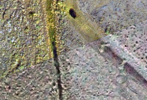
18 Detection Depends on Resolution 0.6 m 1.6 m 0.6 m
19 Extent of Ice Wedge Degradation Water-filled pits (red) in indicate recent degradation, 3.8% of area. Potentially could affect ~20% of area. ~20,000 thermokarst pits in study area Based on spectral analysis of waterbodies Photointerpretatio n Areas 3 x 5 km area
20 Permafrost Degradation Factors Mode Climate Warming Glacial Thermokarst Landscape Position Thermokarst Lake Groundwater Movement Collapse-scar fens Soil Texture Collapse-scar bogs Ice Morphology Collapse-scar pits Ice Content Mixed Pits & Polygons Water tracks & Gullies Piping with Pits Mounds &Hummocks Nonpatterned Size ha km 2 ha km2 ha km2 m ha m m m ha m m n/a
21 Remote Sensing Sampling Design Systematic point sampling with post- stratification by ecological components 9 Transects pnts every 10 km 1 x 1.5 km photo
22

23 Airphoto 1 X 1.5 km, 0.3 m resolution Boundary of 200 x 200 m interpretation area Landsat View Data entry form with dropdown lists Enlargement of Centerpoint
24 Extent of Thermokarst in the Discontinuous Zone in Alaska Thermokarst Extent Thermokarst Modes Unfrozen Initially 26% Unknown 20% Thermokarst 7% Frozen 47 % Thermokarst Pit 7% Collapsescar Bog 7% Collapsescar Fen 46% Glacial Thermokarst 13% Thermokarst Lake 20% Thermokarst Basin 7%
25 Geomorphic Relationships Areal Extent (%) Ice-cored moraine Thermokarst Pit Collapse-scar Fen Collapse-scar Bog Thermokarst Basin Thermokarst Lake Glacial Termokarst Lowland Loess Abandoned Meander Fl... Organic Fen Ice-poor Thaw Lake Margin Deep Thermokarst Lake Area Extent (%) Initially Unfrozen Nonpatterned, Unknown Nonpatterned, Frozen 0 Bedrock, Exposed Residual Soil Weathered Bedrock Hillside Colluvium Talus Retransported Old Moraine
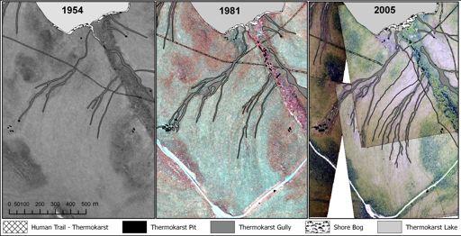
26 Thermokarst Mapping
27 1954 Vegetation Change
28 2004
29 1954 Vegetation Change
30 2004
31
32 A r e L o w l a n d L o w S c Lowland Black Spruce Forest Lowland Mixed Forest Lowland Birch Forest Lowland Fen Meadow E c o s y s t e m T y p e Lowland Bog Meadow Lakes or Ponds Total Degraded Area
33 Lowland Low Scrub (21%) Lowland Black Spruce Forest (11%) Lowland Mixed Forest (7%) 1% 4% 1% 1% 9% 9% 11 % 3% Lowland Low Scrub 0.3 % Lowland Black Spruce Forest (24%) 1% Lowland Mixed Forest (9%) (4%) How much of each ecosystem type? What changed into what? Lowland Birch Forest (23%) 14 % Lowland Birch Forest (15%) 7% Lowland Fen Meadow (31%) 31 % Lowland Fen Meadow (40%) (7%) Lowland Bog Meadow 1% 7% 0.3 % Lowland Bog Meadow (7%)
34 1918 Near Naknek River, King Salmon P. Hagelbarger

35 2005 G. Frost
36 1918 Near Naknek River, King Salmon P. Hagelbarger
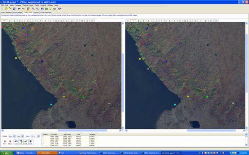
37 1919 Photo by J. Sayre, National Geographic Overlooking area between Lake Grosvenor and lower Savonoski River in 1919 (J. Sayre) and 2005 (T. Jorgenson). Trees and shrubs have overgrown most of the rock outcrops visible in the original image. A lake bottom (far right background) has also drained and become vegetated. Absent in 1919, crustose lichens are now conspicuous on the rocks around Sayre s toppled cairn. This almost certainly represents recovery after disturbance rather than expansion. A possible cause of lichen mortality was acid rain following the eruption of Novarupta in photo courtesy National Geographic Society.

38 2005 Jorgenson
39 1919 Photo by J. Sayre, National Geographic Overlooking area between Lake Grosvenor and lower Savonoski River in 1919 (J. Sayre) and 2005 (T. Jorgenson). Trees and shrubs have overgrown most of the rock outcrops visible in the original image. A lake bottom (far right background) has also drained and become vegetated. Absent in 1919, crustose lichens are now conspicuous on the rocks around Sayre s toppled cairn. This almost certainly represents recovery after disturbance rather than expansion. A possible cause of lichen mortality was acid rain following the eruption of Novarupta in photo courtesy National Geographic Society.
40

41
42
43
44
45 Issues with Using High-res Creating time series (availability, quality) Spatial control (ground, image to image) Co-registration accuracy Whole photo versus subset Resolution differences, minimum detactable change Spectral differences (color, B&W), Interpretation (knowledge of interpreter) Sampling (polygons, lines, circles, points) You need a lot of class! (i.e., classification, what are you detecting)
46 SUMMARY ADVANTAGES High-resolution has a wide range of applications Can assess changes in small features Practical for time-series going back 50+ yrs Manual interpretation for multiple components DISADVANTAGES Limited availability Limited coverage Manual interpretation, consistency
Permafrost-influenced Geomorphic Processes
 Section 4 Permafrost-influenced Geomorphic Processes Geomorphic processes vary greatly among ecoregions in northern Alaska, extending from the Beaufort Sea coast to the Brooks Range (Figure 4.1). Regional
Periglacial Geomorphology
 Periglacial Geomorphology Periglacial Geomorphology Periglacial: literally means around glacial - term introduced in 1909 to describe landforms and processes around glaciated areas. Periglacial environments:
OBSERVATIONS OF PERMAFROST-LANDSCAPE DYNAMICS RELATED TO ANTHROPOGENIC DISTURBANCES, YUKECHI STUDY SITE, CENTRAL YAKUTIA
 OBSERVATIONS OF PERMAFROST-LANDSCAPE DYNAMICS RELATED TO ANTHROPOGENIC DISTURBANCES, YUKECHI STUDY SITE, CENTRAL YAKUTIA A.N. Fedorov, P.Ya. Konstantinov, I.S. Vassiliev, N.P. Bosikov, Ya.I. Torgovkin,
 Page 1 of 9 Name: Base your answer to the question on the diagram below. The arrows show the direction in which sediment is being transported along the shoreline. A barrier beach has formed, creating a
UNIT SEVEN: Earth s Water. Chapter 21 Water and Solutions. Chapter 22 Water Systems. Chapter 23 How Water Shapes the Land
 UNIT SEVEN: Earth s Water Chapter 21 Water and Solutions Chapter 22 Water Systems Chapter 23 How Water Shapes the Land Chapter Twenty-Three: How Water Shapes the Land 23.1 Weathering and Erosion 23.2
PERIGLACIAL PROCESSES & LANDFORMS
 PERIGLACIAL PROCESSES & LANDFORMS Periglacial processes all non-glacial processes in cold climates average annual temperature between -15 C and 2 C fundamental controlling factors are intense frost action
Science EOG Review: Landforms
 Mathematician Science EOG Review: Landforms Vocabulary Definition Term canyon deep, large, V- shaped valley formed by a river over millions of years of erosion; sometimes called gorges (example: Linville
Weathering and Erosion
 Weathering and Erosion OBJECTIVE: Explain how erosion and deposition shape Earth s surface by matching and using models How do erosion and deposition shape Earth s surface? Deposition Formation Transported
Weathering, Erosion, Deposition, and Landscape Development
 Weathering, Erosion, Deposition, and Landscape Development I. Weathering - the breakdown of rocks into smaller particles, also called sediments, by natural processes. Weathering is further divided into
What are the different ways rocks can be weathered?
 Romano - 223 What are the different ways rocks can be weathered? Weathering - the breakdown of rocks and minerals at the Earth s surface 1. 2. PHYSICAL WEATHERING Rock is broken into smaller pieces with
1. Any process that causes rock to crack or break into pieces is called physical weathering. Initial product = final product
 Weathering 1. Any process that causes rock to crack or break into pieces is called physical weathering. Initial product = final product End Result of physical weathering is increased surface area. 2. Physical
Tapped lakes as sediment traps in an Arctic delta
 Sediment Dynamics from the Summit to the Sea 407 (Proceedings of a symposium held in New Orleans, Louisiana, USA, 11 14 December 2014) (IAHS Publ. 367, 2014). Tapped lakes as sediment traps in an Arctic
Pratice Surface Processes Test
 1. The cross section below shows the movement of wind-driven sand particles that strike a partly exposed basalt cobble located at the surface of a windy desert. Which cross section best represents the
Weathering, Erosion & Soils Quiz
 Weathering, Erosion & Soils Quiz Multiple Choice Identify the choice that best completes the statement or answers the question. 1. The diagram below shows a cross-section of a rock layer. Erosion is the
Preliminaries to Erosion: Weathering and Mass Wasting
 Preliminaries to Erosion: Weathering & Mass Wasting All things deteriorate in time. Virgil 1 Preliminaries to Erosion: Weathering and Mass Wasting Denudation The Impact of Weathering and Mass Wasting on
Ch 10 Deposition Practice Questions
 1. Base your answer to the following question on the data table below. Six identical cylinders, A through F, were filled with equal volumes of sorted spherical particles. The data table shows the particle
THE M A NATIONAL EWINATIONS COUNCIL. - = Kenya Certificate of Secondary Education a GEOGRAPHY
 31211 Paper 1 OctJNov. 2010 2% hours THE KENYA NATIONAL EXAMINATIONS COUNCIL Kenya Certificate of Secondary Education Paper 1 * 2% hours Instructions to candidates (a) This paper has two sections: A and
Guido Grosse in collaboration with Katey Walter, Lawrence Plug, Vladimir Romanovsky, Mary Edwards, Lee Slater, Meghan Tillapaugh and Melanie Engram
 Monitoring thaw lake dynamics using high-resolution remote sensing Examples from the Cape Espenberg area (Seward Peninsula) and the Kolyma lowland (Siberia) Guido Grosse in collaboration with Katey Walter,
Unit 3 Review - Surface Processes
 Unit 3 Review - Surface Processes 1. Why is the surface of Mercury covered with meteor impact craters, while Earth s surface has relatively few craters? A) Mercury is larger than Earth, so it gets hit
EVOLUTION OF A PERMAFROST-DOMINATED LANDSCAPE ON THE COLVILLE RIVER DELTA, NORTHERN ALASKA
 EVOLUTION OF A PERMAFROST-DOMINATED LANDSCAPE ON THE COLVILLE RIVER DELTA, NORTHERN ALASKA M. Torre Jorgenson 1, Yuri L. Shur 2, H. Jesse Walker 3 1. 2. ABR, Inc., PO Box 80410,Fairbanks, AK 99708 2 Presently
Erosion and Deposition
 Erosion and Deposition Erosion Sediment natural forces move rock/soil from one place to another. gravity, water, wind, glaciers, waves are causes material moved by erosion Deposition when erosion lays
Earth Science Chapter 9. Day 6 - Finish Capillary Action Lab - Quiz over Notes - Review Worksheets over Sections 9.2 and 9.3
 Earth Science Chapter 9 Day 1 Day 2 Day 3 Read Section 9.1 Surface Water Chapter 9 Term Sheet Notes over Section 9.1 Surface Water Section 9.1 Review Worksheets Quiz over Section 9.1 Notes Virtual Lab
Weathering, Erosion, and Deposition Guided Notes
 1. Weathering, Erosion, and Deposition 2. Outline Section 1: Weathering Section 2: Erosion Section 3: Deposition Section 4: Case Study Weathering, Erosion, and Deposition Guided Notes 3. Section 1: Weathering
Geology and New England Landscapes
 Geology and New England Landscapes Jim Turenne, CPSS USDA-NRCS Warwick, RI. http://nesoil.com Why Geology? Provides the big picture of site conditions. Major part of soil formation (parent material and
Weathering, Erosion, Deposition
 Weathering, Erosion, Deposition The breakdown of rocks at or near the Earth s Surface. Physical Chemical - The breakdown of rock into smaller pieces without chemical change. - Dominant in moist /cold conditions
Weathering and Soil Formation. Chapter 10
 Weathering and Soil Formation Chapter 10 Old and New Mountains The Appalachian Mountains appear very different from the Sierra Mountains. The Appalachians are smaller, rounded, gently sloping, and covered
EARTH S CHANGING SURFACE
 EARTH S CHANGING SURFACE Weathering Together, weathering and erosion work continuously to wear down the material on Earth s surface. weathering process that breaks down rock and other substances of Earth
THE SCIENCE OF MAPS. ATL Skill: Critical thinking - Use models and simulations to explore complex systems and issues
 THE SCIENCE OF MAPS 8.9C interpret topographic maps and satellite views to identify land and erosional features and predict how these features may be reshaped by weathering ATL Skill: Critical thinking
Physical Geology, 15/e
 Lecture Outlines Physical Geology, 15/e Plummer, Carlson & Hammersley Weathering and Soil Physical Geology 15/e, Chapter 5 Weathering, Erosion and Transportation Rocks exposed at Earth s surface are constantly
ENVIRONMENTAL GEOSCIENCE UNIFORM SYLLABUS
 ENVIRONMENTAL GEOSCIENCE UNIFORM SYLLABUS The Association of Professional Engineers and Geoscientists of the Province of British Columbia Note: 1. This Syllabus May Be Subject To Change 2. These Courses
What is weathering and how does it change Earth s surface? Answer the question using
 7 th Grade Lesson What is weathering and how does it change Earth s surface? Answer the question using the sentence frame. You have 4 minutes. Weathering is. This changes the Earth s surface because. 1
Lecture 10 Glaciers and glaciation
 Lecture 10 Glaciers and glaciation Outline Importance of ice to people! Basics of glaciers formation, classification, mechanisms of movement Glacial landscapes erosion and deposition by glaciers and the
Soil is formed from the weathering of rocks. Weathering: the breaking down of parent material (rock). There are 3 types of weathering:
. There are 3 types of weathering:") Soil is formed from the weathering of rocks. Weathering: the breaking down of parent material (rock). There are 3 types of weathering: Physical, Chemical Biological. The natural forces carry this out:
Soil is formed from the weathering of rocks. Weathering: the breaking down of parent material (rock). There are 3 types of weathering: Physical, Chemical Biological. The natural forces carry this out:
Permafrost Related Causes and. Consequences of the Sagavanirktok River Flooding in Spring 2015
 Permafrost-Related Causes and Consequences of the Sagavanirktok River Delta Flooding in Spring 2015 Permafrost Related Causes and Consequences of the Sagavanirktok River Flooding in Spring 2015 Yuri Shur
1/6/ th Grade Earth s Surface. Chapter 3: Erosion and Deposition. Lesson 1 (Mass Movement)
") Lesson 1 (Mass Movement) 7 th Grade Earth s Surface Chapter 3: Erosion and Deposition Weathering the chemical and physical processes that break down rock at Earth s surface Mechanical weathering when rock
Lesson 1 (Mass Movement) 7 th Grade Earth s Surface Chapter 3: Erosion and Deposition Weathering the chemical and physical processes that break down rock at Earth s surface Mechanical weathering when rock
4. The map below shows a meandering stream. Points A, B, C, and D represent locations along the stream bottom.
 1. Sediment is deposited as a river enters a lake because the A) velocity of the river decreases B) force of gravity decreases C) volume of water increases D) slope of the river increases 2. Which diagram
REMOTE SENSING OF PERMAFROST IN NORTHERN ENVIRONMENTS
 REMOTE SENSING OF PERMAFROST IN NORTHERN ENVIRONMENTS What is permafrost? What can we monitor with satellite data? Permafrost is an Essential Climate Variable About 25 % of the land surface is underlain
How does Rock become Exposed to the Surface?
 Weathering How does Rock become Exposed to the Surface? Most rocks, like granite, form under earth s surface. The rocks uplift and eventually make their way to earth s surface. Conditions on the surface
Lab 7: Sedimentary Structures
 Name: Lab 7: Sedimentary Structures Sedimentary rocks account for a negligibly small fraction of Earth s mass, yet they are commonly encountered because the processes that form them are ubiquitous in the
Weathering Erosion and Deposition. Presented by Kesler Science
 Weathering Erosion and Deposition Presented by Kesler Science Essential Questions: 1. What effects do weathering, erosion, and deposition have on the environment in ecoregions? Weathering Chemical and
Name. 4. The diagram below shows a soil profile formed in an area of granite bedrock. Four different soil horizons, A, B, C, and D, are shown.
 Name 1. In the cross section of the hill shown below, which rock units are probably most resistant to weathering? 4. The diagram below shows a soil profile formed in an area of granite bedrock. Four different
Constructive and Destructive Forces. Processes That Act Upon Earth s Surface Features
 Constructive and Destructive Forces Processes That Act Upon Earth s Surface Features What are Constructive and Destructive Forces? Constructive Force A constructive force is a process that raises or builds
Day 3 Weathering and Erosion.notebook. October 02, Section 7.2. Erosion and Deposition. Objectives
 Objectives Describe the relationship of gravity to all agents of erosion. Contrast the features left from different types of erosion. Analyze the impact of living and nonliving things on the processes
Detecting Landscape Changes in High Latitude Environments Using Landsat Trend Analysis: 2. Classification
 1 Detecting Landscape Changes in High Latitude Environments Using Landsat Trend Analysis: 2. Classification Ian Olthof and Robert H. Fraser Canada Centre for Mapping and Earth Observation Natural Resources
Page 1. Name:
 Name: 1) Which event is the best example of erosion? dissolving of rock particles on a limestone gravestone by acid rain breaking apart of shale as a result of water freezing in a crack rolling of a pebble
CR AAO Bridge. Dead River Flood & Natural Channel Design. Mitch Koetje Water Resources Division UP District
 CR AAO Bridge Dead River Flood & Natural Channel Design Mitch Koetje Water Resources Division UP District Old County Road AAO Bridge Map courtesy of Marquette County Silver Lake Basin McClure Basin
Figure 1 The map shows the top view of a meandering stream as it enters a lake. At which points along the stream are erosion and deposition dominant?
 1. In which type of climate does chemical weathering usually occur most rapidly? 1. hot and dry 3. cold and dry 2. hot and wet 4. cold and wet 2. Figure 1 The map shows the top view of a meandering stream
3.2.2 Ecological units of the Des Quinze lake proposed biodiversity reserve
 3.2.2 Ecological units of the proposed biodiversity reserve An intact forest mass The proposed biodiversity reserve (see appendix 3) protects terrestrial environments almost exclusively. Proximity of Des
Year 6. Geography. Revision
 Year 6 Geography Revision November 2017 Rivers and World knowledge How the water cycle works and the meaning of the terms evaporation, condensation, precipitation, transpiration, surface run-off, groundwater
Weathering Notes. When the mineral composition of the rock is changed
 Weathering Notes Weathering Weathering is the breaking down on rocks into smaller pieces Two types of weathering o Physical (mechanical) When the mineral composition of the rock isn t changed Ex: Smashing
1. The diagram below shows the stump of a tree whose root grew into a small crack in bedrock and split the rock apart.
 1. The diagram below shows the stump of a tree whose root grew into a small crack in bedrock and split the rock apart. 4. Which process involves either a physical or chemical breakdown of earth materials?
WEATHERING, EROSION & DEPOSITION STUDY GUIDE
 WEATHERING, EROSION & DEPOSITION STUDY GUIDE Weathering: The difference between mechanical & chemical weathering is: Sort terms as being mechanical/physical or chemical weathering: acid rain, root splitting
1. Which type of climate has the greatest amount of rock weathering caused by frost action? A) a wet climate in which temperatures remain below
 a wet climate in which temperatures remain below") 1. Which type of climate has the greatest amount of rock weathering caused by frost action? A) a wet climate in which temperatures remain below freezing B) a wet climate in which temperatures alternate
1. Which type of climate has the greatest amount of rock weathering caused by frost action? A) a wet climate in which temperatures remain below freezing B) a wet climate in which temperatures alternate
Earth Science. STREAM DRAINAGE PATTERNS (start by reading the first page of these notes!)
") Name _ Earth Science STREAM DRAINAGE PATTERNS (start by reading the first page of these notes!) WHAT IS A DRAINAGE PATTERN? Streams seek the lowest path as they move downhill, and they tend to erode their
Name _ Earth Science STREAM DRAINAGE PATTERNS (start by reading the first page of these notes!) WHAT IS A DRAINAGE PATTERN? Streams seek the lowest path as they move downhill, and they tend to erode their
Watershed concepts for community environmental planning
 Purpose and Objectives Watershed concepts for community environmental planning Dale Bruns, Wilkes University USDA Rural GIS Consortium May 2007 Provide background on basic concepts in watershed, stream,
Chapter 3 Erosion and Deposition. The Big Question:
 Chapter 3 Erosion and Deposition The Big Question: 1 Design a way to represent and describe the 4 types of mass movement. You may use pictures, diagrams, list, web, chart, etc 2 Chapter 3: Erosion and
8UNIT. External dynamics of the Earth. What do you remember? Key language. Content objectives
 8UNIT External dynamics of the Earth What do you remember? Can you name the solids in the photograph? nd the liquid? Is the liquid moving? How does it move? What is the name of this formation of water?
STUDY GUIDE FOR CONTENT MASTERY. Surface Water Movement
 Surface Water SECTION 9.1 Surface Water Movement In your textbook, read about surface water and the way in which it moves sediment. Complete each statement. 1. An excessive amount of water flowing downslope
Topic 6: Weathering, Erosion and Erosional-Deposition Systems (workbook p ) Workbook Chapter 4, 5 WEATHERING
 Workbook Chapter 4, 5 WEATHERING") Topic 6: Weathering, Erosion and Erosional-Deposition Systems (workbook p. 95-125) Workbook Chapter 4, 5 THE BIG PICTURE: Weathering, erosion and deposition are processes that cause changes to rock material
Topic 6: Weathering, Erosion and Erosional-Deposition Systems (workbook p. 95-125) Workbook Chapter 4, 5 THE BIG PICTURE: Weathering, erosion and deposition are processes that cause changes to rock material
Weathering & Erosion
 Name Test Date Hour Earth Processes#1 - Notebook Weathering & Erosion LEARNING TARGETS I can explain the process of weathering. I can explain why weathering is important. I can describe the difference
Tips for Success on a Test
 Number of Incorrect: Final Grade: Parent Signature: Top Tips for Success on a Test 1. Read the following statements at least two times. 2. Circle the key words in each question/ or statement. (*Remember
Evidence for Permafrost on Long Island
 Evidence for Permafrost on Long Island By Vesna Kundic and Gilbert N. Hanson Department of Geosciences Stony Brook University Permafrost or permanently frozen ground is soil or rock that remains below
Soil Formation. Parent Material. Time. Climate
 Soil Formation Parent Material Time Climate Topography Biota Main Objectives 1. Gain a general understanding of soil formation processes 2. Understand the importance of mineral weathering in soil formation
Maggie Payne Jim Turenne
 Maggie Payne Jim Turenne USDA-NRCS 60 Quaker Lane, Suite 46 Warwick, RI. 02886 401-822-8832 maggie.payne@ri.usda.gov U.S. Department of Agriculture 1935: Soil Conservation Service (SCS) Natural Resources
Weathering, Soil, & Mass Movements. Chapter 5
 Weathering, Soil, & Mass Movements Chapter 5 5.1 Weathering Weathering: the breaking down and changing of rocks at or near the Earth s surface. Basic part of the rock cycle. 2 main types: 1. Mechanical
Biosphere. All living things, plants, animals, (even you!) are part of the zone of the earth called the biosphere.
 are part of the zone of the earth called the biosphere.") Unit 1 Study Guide Earth s Spheres Biosphere All living things, plants, animals, (even you!) are part of the zone of the earth called the biosphere. Hydrosphere Water covers ¾ of the earth, made up mostly
Unit 1 Study Guide Earth s Spheres Biosphere All living things, plants, animals, (even you!) are part of the zone of the earth called the biosphere. Hydrosphere Water covers ¾ of the earth, made up mostly
COMBINING ALOS DATA AND FIELD INVESTIGATIONS FOR THE RECONSTRUCTION OF THERMOKARST EVOLUTION IN THE NORTH SIBERIAN LENA DELTA
 COMBINING ALOS DATA AND FIELD INVESTIGATIONS FOR THE RECONSTRUCTION OF THERMOKARST EVOLUTION IN THE NORTH SIBERIAN LENA DELTA Anne Morgenstern (1), Mathias Ulrich (1), Frank Guenther (1), Sebastian Roessler
10/27/2014. Surface Processes. Surface Processes. Surface Processes. Surface Processes. Surface Processes
 Hewitt/Lyons/Suchocki/Yeh Conceptual Integrated Science Chapter 25 Surface or surficial processes originate at Earth's surface and reshape its contours. Surface processes include: Weathering Erosion Deposition
AN ASSESSMENT OF GROUND ICE VOLUME NEAR EUREKA, NORTHWEST TERRITORIES
 AN ASSESSMENT OF GROUND ICE VOLUME NEAR EUREKA, NORTHWEST TERRITORIES Nicole J. Couture, Wayne H. Pollard Department of Geography McGill University 805 Sherbrooke St. W. Montreal, Quebec H3A 2K6 e-mail:
Weathering of Rocks. Weathering - Breakdown of rocks into pieces (sediment) 2 main types of weathering to rocks
 2 main types of weathering to rocks") Weathering of Rocks Weathering - Breakdown of rocks into pieces (sediment) 2 main types of weathering to rocks Mechanical weathering requires physical forces to break rocks into smaller pieces. Chemical
Weathering of Rocks Weathering - Breakdown of rocks into pieces (sediment) 2 main types of weathering to rocks Mechanical weathering requires physical forces to break rocks into smaller pieces. Chemical
Weathering, Mass Wasting and Karst
 Weathering, Mass Wasting and Karst Capable of wearing down anything that the internal processes can build. Gravity, water, wind and ice Denudation - the overall effect of disintegration, wearing away and
Periglacial processes, features & landscape development /4 Glacial Systems and landscapes
 Periglacial processes, features & landscape development 3.1.4.3/4 Glacial Systems and landscapes What you need to know Where periglacial landscapes are found and what their key characteristics are The
Objectives: Define Relative Age, Absolute Age
 S6E5. Students will investigate the scientific view of how the earth s surface is formed. c. Classify rocks by their process of formation. g. Describe how fossils show evidence of the changing surface
water erosion lithosphere Describe the process of erosion and deposition. chemical weathering Dissolving limestone is an example of.
 At one time, there was one large island off the coast of Mississippi and now it is two separate islands. What caused the island to be split into two? water erosion The crust and the top part of the upper
Permafrost: Earth Observation Applications: Introduction
 Polar Meeting 3 Permafrost: Earth Observation Applications: Introduction Mark Drinkwater CNES, Paris, 22 23 May, 2013 Remote Sensing of Permafrost which Remote Sensing products? applicability to Permafrost
ECOLOGICAL SUCCESSION. Prof :DEEPAK SAINI HOD ZOOLOGY J.C.D.A.V. College,Dasuya
 ECOLOGICAL SUCCESSION Prof :DEEPAK SAINI HOD ZOOLOGY J.C.D.A.V. College,Dasuya Primary succession: The gradual establishment, through stages, of a climax ecosystem, that has not been occupied before. Primary
Which map shows the stream drainage pattern that most likely formed on the surface of this volcano? A) B)
 B)") 1. When snow cover on the land melts, the water will most likely become surface runoff if the land surface is A) frozen B) porous C) grass covered D) unconsolidated gravel Base your answers to questions
1. When snow cover on the land melts, the water will most likely become surface runoff if the land surface is A) frozen B) porous C) grass covered D) unconsolidated gravel Base your answers to questions
mountain rivers fixed channel boundaries (bedrock banks and bed) high transport capacity low storage input output
 high transport capacity low storage input output") mountain rivers fixed channel boundaries (bedrock banks and bed) high transport capacity low storage input output strong interaction between streams & hillslopes Sediment Budgets for Mountain Rivers Little
mountain rivers fixed channel boundaries (bedrock banks and bed) high transport capacity low storage input output strong interaction between streams & hillslopes Sediment Budgets for Mountain Rivers Little
Earth processes are dynamic actions that occur both on
 29 Weathering, Erosion, and Deposition R EA D I N G Earth processes are dynamic actions that occur both on the earth s surface and inside the earth. Any process that breaks down earth material, such as
Unit 7.2 W.E.D. & Topography Test
 Name: Score: Unit 7.2 W.E.D. & Topography Test 1. 2. 3. 4. 5. 6. 7. 8. 9. 10. 11. 12. 13. 14. 15. 16. 17. 18. 19. 20. 21. 22. 23. 24. 25. 1. The formation of mountains is due mainly to while the destruction
Evolution of lakes and basins in northern Alaska and discussion of the thaw lake cycle
 JOURNAL OF GEOPHYSICAL RESEARCH, VOL. 112,, doi:10.1029/2006jf000531, 2007 Evolution of lakes and basins in northern Alaska and discussion of the thaw lake cycle M. Torre Jorgenson 1 and Yuri Shur 2 Received
Name: Mid-Year Review #2 SAR
 Name: Mid-Year Review #2 SAR Base your answers to questions 1 through 3 on on the diagram below, which shows laboratory materials used for an investigation of the effects of sediment size on permeability,
Surface Events & Landforms. Mrs. Green
 Surface Events & Landforms Mrs. Green Bell Work 1) Which event MOST likely causes the slowest change to the surface of Earth? a) Earthquake b) Landslide c) Volcano d) Wind 2) When cold weather freezes
The Effect of Weather, Erosion, and Deposition in Texas Ecoregions
 The Effect of Weather, Erosion, and Deposition in Texas Ecoregions 7.8B: I can analyze the effects of weathering, erosion, and deposition on the environment in ecoregions of Texas Weathering The breakdown
Gelisols are soils affected by permafrost.
 Published May 8, 2013 Gelisols: Part I. Cryogenesis and State Factors of Formation C.L. Ping Guest Columns Editor's note: This is the first in a two-part series on Gelisols. Part I examines the cryogenesis
Glacial landscape. Arid Landscape. Geological feature. Extreme drainage. In this location you should find the following features:
 Glacial landscape In this location you should find the following features: Alluvial fan Braided river End moraines Glacial niche Talus cone U-valley Try to determine the altitude of the tree limit in the
EQ: Discuss main geographic landforms of the U.S. & Canada and examine varied landforms in relation to their lifestyles.
 EQ: Discuss main geographic landforms of the U.S. & Canada and examine varied landforms in relation to their lifestyles. Places & Terms for Discussion Appalachian Mountains Great Plains Canadian Shield
Mechanical Weathering
 Weathering is the disintegration and decomposition of material at or near the surface. Erosion is the incorporation and transportation of material by a mobile agent, usually water, wind, or ice. Geologists
Glaciers. 1. The photograph below shows the results of a landslide.
 Name: Date: 1. The photograph below shows the results of a landslide. This landslide is an example of A) wind abrasion B) glacial deposition C) wave action D) mass movement 2. Which agent of erosion is
Circle the best answer for each question. There are a total of 50 questions.
 Winter Packet 2013 Name Period ircle the best answer for each question. There are a total of 50 questions. 1. What occurs when ions from the Sun hit air molecules and cause them to emit vivid colors of
Surface Water Short Study Guide
 Name: Class: Date: Surface Water Short Study Guide Multiple Choice Identify the letter of the choice that best completes the statement or answers the question. 1. The three ways in which a stream carries
1. The map below shows a meandering river. A A' is the location of a cross section. The arrows show the direction of the river flow.
 1. The map below shows a meandering river. A A' is the location of a cross section. The arrows show the direction of the river flow. Which cross section best represents the shape of the river bottom at
Jim Turenne. Soils on Social Media
 Jim Turenne USDA-NRCS 60 Quaker Lane, Suite 46 Warwick, RI. 02886 401-822-8832 Jim.turenne@ri.usda.gov Soils on Social Media www.twitter.com/soilsne www.fb.com/soilsne www.nesoil.com U.S. Department of
Objectives. Introduction to Soils. Terms to know: What is soil? Study of Soils. The Soil Body 11/9/2012
 Objectives Explain what soil is and where it comes from Define a soil body List examples of the five soil-forming factors Explain how soils develop Introduction to Soils Terms to know: What is soil? Alluvial
Landscape. Review Note Cards
 Landscape Review Note Cards Last Ice Age Pleistocene Epoch that occurred about 22,000 Years ago Glacier A large, long lasting mass of ice which forms on land and moves downhill because of gravity. Continental
HW #2 Landscape Travel from A to B 12,
 HW #2 Landscape 2016 Section: Name: ate: 1. ase your answer(s) to the following question(s) on the map below, which represents two bridges that cross the Green River. Letters,, and represent locations
Changing Earth s Surface
 Name Date Class Changing Earth s Surface What processes wear down and build up Earth s surface? What causes the different types of mass movement? Erosion is the process by which natural forces move weathered
Biomes There are 2 types: Terrestrial Biomes (on land) Aquatic Biomes (in the water)
 Aquatic Biomes (in the water)") Biomes There are 2 types: Terrestrial Biomes (on land) Aquatic Biomes (in the water) Terrestrial Biomes Grassland, Desert, and Tundra Biomes: Savanna Temperate grassland Chaparral Desert Tundra Chapter
Biomes There are 2 types: Terrestrial Biomes (on land) Aquatic Biomes (in the water) Terrestrial Biomes Grassland, Desert, and Tundra Biomes: Savanna Temperate grassland Chaparral Desert Tundra Chapter
Changes to Land 5.7B. landforms: features on the surface of Earth such as mountains, hills, dunes, oceans and rivers
 All the landforms on Earth have changed over time and continue to change. Many of the changes were caused by wind, moving water, and moving ice. Mountains have grown and shrunk. Rivers have cut away land
Erosion and Deposition
 CHAPTER 3 LESSON 2 Erosion and Deposition Landforms Shaped by Water and Wind Key Concepts What are the stages of stream development? How do water erosion and deposition change Earth s surface? How do wind