Guido Grosse in collaboration with Katey Walter, Lawrence Plug, Vladimir Romanovsky, Mary Edwards, Lee Slater, Meghan Tillapaugh and Melanie Engram
|
|
|
- Tamsyn Carpenter
- 5 years ago
- Views:
Transcription
 and the")


1 Monitoring thaw lake dynamics using high-resolution remote sensing Examples from the Cape Espenberg area (Seward Peninsula) and the Kolyma lowland (Siberia) Guido Grosse in collaboration with Katey Walter, Lawrence Plug, Vladimir Romanovsky, Mary Edwards, Lee Slater, Meghan Tillapaugh and Melanie Engram High-Resolution Imagery for Analysis of Environmental Change in Northern Alaska (17 October 2008)
 - Thickness of the deposit is")


,")
2 Distribution of Ice-Rich Yedoma Deposits Walter et al., 2007 (Science) - Thickness of the deposit is between 5-100m - Present day total coverage is > 1x10 6 km - Gravimetric ground ice contents in the sediments between % - Including the ice wedges, total volumetric ice content of up to >75% - Organic carbon content averages between 2-5% - Accumulation during several years - Stores about 500 Gt of organic carbon in thaw-vulnerable permafrost Zimov et al 2006 (Science), Schirrmeister et al., 2008 (NICOP)


3 Bolshoy Lyakhovsky Island Ice-rich Yedoma Permafrost in Beringia??? Muostakh Island Oyagoss Yar coast Duvanny Yar, Kolyma River Photo: V. Rachold

4 Thermokarst and C-Cycle Thermokarst lake model Yedoma thermokarst lakes: Tg/yr CH % increase compared to former northern wetland emission estimates Walter et al, 2007 (Phil. Trans. Royal Soc. A)
 Ice core CH 4 (ppbv ) Number of 14 C dates (% of total) Number of thermokarst - lake basal dates per millennium 90 80 A 70 60 60 50 40 30")

 Age ( kyr B.P.")
5 Thermokarst and C-Cycle Thermokarst Lakes as a Source of Atmospheric CH 4 During the Last Deglaciation Olenek Channel, Lena Delta Kolyma Lowland Northern CH 4 emissions (Tg yr -1 ) Ice core CH 4 (ppbv ) Number of 14 C dates (% of total) Number of thermokarst - lake basal dates per millennium A B GISP2 (3) northern peatlands C D Taylor Dome lake CH 4 thermokarst lakes Early Holocene thermokarst lake flare-up in ice-rich Yedoma was a considerable northern methane source (33-87% of Early Holocene high latitude methane increase). Thermokarst -lake CH 4 emissions (Tg yr -1 ) E 25 CH 4 shelf yedoma Exposed yedoma area (10 6 km 2 ) Age ( kyr B.P.) Walter et al, 2007 (Science)

6 Thermokarst Lakes: Permafrost Degradation and C-cycling in the Arctic Carbon Cycle Sciences Assessing the spatial and temporal dynamics of thermokarst, methane emissions, and related carbon cycling in Siberia and Alaska G. Grosse, K. Walter, V. Romanovsky IPY OPP IPY: Understanding the impacts of thermokarst lakes on C-cycling and climate change K. Walter, G. Grosse, L. Plug, M. Edwards, L. Slater Remote sensing, change detection, spatial upscaling G. Grosse, USA Integration into Earth system models P. Valdes, UK Paleoecology and paleoenvironmental dynamics M. Edwards, USA+UK Thermokarst Lake Dynamics Permafrost modeling V. Romanovsky, USA Biogeochemistry and greenhouse gas fluxes K. Walter, USA Numerical modeling of lakes and landscapes L. Plug, CAN Geophysics of thaw bulbs and sediment gas contents L. Slater, USA Carbon cycling S. Zimov, Russia

7 Study Areas Kolyma Lowland Seward Peninsula Alaska Siberia

8 Northern Seward Peninsula

9 Kolyma Lowland, Cherskii region
10 Remote Sensing Datasets Seward Peninsula Air photos (1m) - Kolyma Lowland Corona KH-4 (8m) Corona KH-4A (2.5m), Gambit KH-7 (1m) Air photos (1m) Air photos (1m) Air photos (0.6m) Ikonos-2 (1m) LIDAR (0.5m) TerraSAR-X (1m) Ikonos-2 (1m) ALOS PRISM (2.5m) TerraSAR-X (1m) Quickbird (0.8) SPOT-5 (2.5) > 55 years coverage > 40 years coverage


11 Orthorectified Aerial Imagery - Manley et al - ~1950, ~1980, ground resolution: 1 m, 1 m, 0.6 m - panchromatic, color-infrared, color
 -")
12 Ikonos / ground resolution: 1 m - multispectral Imagery provided by NPS Corona KH ground resolution: 25 ft (~8m) - panchromatic
13 Corona KH-4A ground resolution: 2.5 m - panchromatic - Each image stripe is about 150x17 km


14 ALOS PRISM Ground resolution: 2.5m - panchromatic - Stereo triplets

15 Gambit KH ground resolution: 1 m - panchromatic - covers vicitiniy of city of Cherskii


16 LIDAR point spacing: 0.5 m - NOAA

17 LIDAR point spacing: 0.5 m - NOAA


18 TerraSAR-X - X-band SAR - Spotlight mode with 1 m ground resolution - Dual polarization possible Seward Peninsula; 2009 Kolyma Lowland -Testing the identification and quantification of methane bubbles in thermokarst lake ice
19 Software Tools Image processing and spatial data analysis ENVI (ITT) Erdas Imagine (Leica Geosystems) ArcGIS (ESRI) Object-based image classification ArcGIS Feature Analyst (ESRI) Definiens Developer (ecognition)

20 1951 Seward Peninsula

21 1978

22 2003


23 Lake area in % Lake Claudi Lake Rhonda


24 Permafrost collapse zones and floating vegetation mats


25 Only observation of formation of new lake


26 1962 Lake Drainage ha 40.4 ha ha

! (1 m ground resolution)!")
27 Temporal Changes of Thermokarst Lakes in Siberian Yedoma Thermo-erosion along shore bluffs of thermokarst lakes in the Cherskii region (Gambit 1965 vs. Ikonos )! (1 m ground resolution)! September 2007


28 Distribution and Temporal Changes of Thermokarst Lakes in Siberian Yedoma G. Grosse, V. Romanovsky, K. Walter, A. Morgenstern, H. Lantuit, S. Zimov Thermo-erosion along shore bluffs of thermokarst lakes (Gambit 1965 vs. Ikonos ) (1 m ground resolution)
 (Gambit 1965 vs. Ikonos-2 2002) (1.")
29 Human impact on permafrost Massive thermokarst pond formation along former dirt roads, Cherskii (Russia) (Gambit 1965 vs. Ikonos ) (1.0 m ground resolution)
 (Gambit 1965 vs. Ikonos-2 2002) (1.")
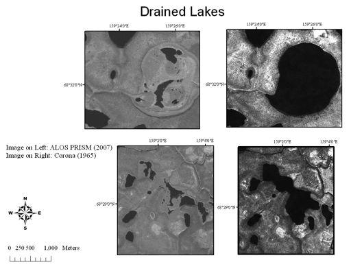
30 Human impact on permafrost Artificial drainage of a thermokarst lake, followed by the formation of retrogressive thaw slumps, Cherskii (Russia) (Gambit 1965 vs. Ikonos ) (1.0 m ground resolution)
 - Covers >10,000 km 2 in 2.")

31 Modern Thermokarst Dynamics in Northeast Siberia: The Kolyma Lowland Transect - Land surface record is 42 years long ( ) - Covers >10,000 km 2 in 2.5 m ground resolution - Crosses a broad variety of hydrological, geological and permafrost conditions - Largest lake has surface area of 230 km 2 Geological map 1:1,000,000
32
33 Summary of First Results Seward Peninsula - All lakes visually inspected show signs of rapid expansion up to 1 m/yr - Extensive permafrost collapse areas on lake margins are camouflaged by floating vegetation mats (FVM); collapse zones expand with more than 1 m/yr - Low shorelines towards old basins appear to erode more rapid than high bluffs! impact of ice content and sediment volume that has to be removed - Some considerably large lakes drained partially or completely - Very few new lakes formed - Direct impact of long-term precipitation fluctuations on water level appears to be negligible compared to thermokarst and erosion dynamics; however, short-term precipitation events might be a cause for activating or speeding up both erosion and drainage processes Kolyma Lowland - Only lakes in Yedoma deposits around Cherskii were assessed so far - Human disturbance results in massive thermokarst - Erosion rates are similar to Seward Peninsula
34 Conclusions A wide range of high-resolution remote sensing platforms are available today for Arctic Research Remote sensing is highly valuable to assess the spatial dimensions of environmental change in the Arctic Using remote sensing we can cover 42 years of land surface changes in the Kolyma lowland and 56 years on the Seward Peninsula Thermokarst is highly dynamic and active today in Siberia and Alaska probably we will see surprising results and feedbacks in the coming years Thermokarst lakes behave nonlinear in their spatial dynamics; driven by cryolithological ground conditions and external forcing, slow lake forming processes are accompanied by phases of rapid expansion or sudden drainage
Permafrost: Earth Observation Applications: Introduction
 Polar Meeting 3 Permafrost: Earth Observation Applications: Introduction Mark Drinkwater CNES, Paris, 22 23 May, 2013 Remote Sensing of Permafrost which Remote Sensing products? applicability to Permafrost
Hopkins Fellowship 3/20/2010
 Thermokarst lakes are an important part of the global carbon cycle, releasing an estimated 24.2 +/- 10.5 Tg CH 4 yr -1 into the atmosphere (Walter et al. 2007). Recent research indicates the potential
Permafrost-influenced Geomorphic Processes
 Section 4 Permafrost-influenced Geomorphic Processes Geomorphic processes vary greatly among ecoregions in northern Alaska, extending from the Beaufort Sea coast to the Brooks Range (Figure 4.1). Regional
Product Guide: TerraSAR-X derived Cliff Top Retreat
 Product Guide: TerraSAR-X derived Cliff Top Retreat Stettner, Samuel 1), Bartsch, Annett 2),3), Widhalm, Barbara 2,3), Heim, Birgit 1), Günther, Frank 1), Morgenstern, Anne 1) 1) Alfred-Wegener-Institut,
COMBINING ALOS DATA AND FIELD INVESTIGATIONS FOR THE RECONSTRUCTION OF THERMOKARST EVOLUTION IN THE NORTH SIBERIAN LENA DELTA
 COMBINING ALOS DATA AND FIELD INVESTIGATIONS FOR THE RECONSTRUCTION OF THERMOKARST EVOLUTION IN THE NORTH SIBERIAN LENA DELTA Anne Morgenstern (1), Mathias Ulrich (1), Frank Guenther (1), Sebastian Roessler
The polygenetic hypothesis of Yedoma origin comparing grain-size distributions of Alaskan and Siberian Yedoma
 The polygenetic hypothesis of Yedoma origin comparing grain-size distributions of Alaskan and Siberian Yedoma Lutz Schirrmeister, Guido Grosse, Jens Strauss, Elisabeth Dietze, Sebastian Wetterich Alfred
REMOTE SENSING OF PERMAFROST IN NORTHERN ENVIRONMENTS
 REMOTE SENSING OF PERMAFROST IN NORTHERN ENVIRONMENTS What is permafrost? What can we monitor with satellite data? Permafrost is an Essential Climate Variable About 25 % of the land surface is underlain
Pan-Arctic permafrost thermal conditions: Where does the Yamal Peninsula fit?
 Pan-Arctic permafrost thermal conditions: Where does the Yamal Peninsula fit? V. Romanovsky, A. Kholodov and S. Marchenko University of Alaska Fairbanks 1600 The Mammoth Steppe Concept: R. D. Guthrie,
Modern thermokarst lake dynamics in the continuous permafrost zone, northern Seward Peninsula, Alaska
 JOURNAL OF GEOPHYSICAL RESEARCH, VOL. 116,, doi:10.1029/2011jg001666, 2011 Modern thermokarst lake dynamics in the continuous permafrost zone, northern Seward Peninsula, Alaska B. M. Jones, 1,2 G. Grosse,
Using High-Resolution Airphotos for Assessing Landscape Change. Torre Jorgenson
 Using High-Resolution Airphotos for Assessing Landscape Change Torre Jorgenson It s All a Matter of Scale Landsat TM 28-m pixel Ikonos Fused 1-m pixel Digital Camera 0.2-m pixel Examples of Landscape
Leaking lakes. Methane is a very potent greenhouse gas that is 25 to 28 times more powerful than carbon dioxide at retaining heat in the atmosphere.
 Leaking lakes Methane is a very potent greenhouse gas that is 25 to 28 times more powerful than carbon dioxide at retaining heat in the atmosphere. Melanie Engram University of Alaska Fairbanks by Jane
Detecting Landscape Changes in High Latitude Environments Using Landsat Trend Analysis: 2. Classification
 1 Detecting Landscape Changes in High Latitude Environments Using Landsat Trend Analysis: 2. Classification Ian Olthof and Robert H. Fraser Canada Centre for Mapping and Earth Observation Natural Resources
A new window on Arctic greenhouse gases: Continuous atmospheric observations from Ambarchik on the Arctic coast in North-Eastern Siberia
 A new window on Arctic greenhouse gases: Continuous atmospheric observations from Ambarchik on the Arctic coast in North-Eastern Siberia Friedemann Reum 1, Mathias Göckede 1, Nikita Zimov 3, Sergej Zimov
1 st Newsletter. IPA Task Force on Remote Sensing of Permafrost
 1 st Newsletter IPA Task Force on Remote Sensing of Permafrost Co Chairs: Guido Grosse (UAF; ffgg1@uaf.edu) & Claude Duguay (University of Waterloo; crduguay@uwaterloo.ca) http://www.permafrostwatch.org/news/ipa_taskforce_remotesensing.html
Polar Space Task Group Permafrost Review of Requirements, Achievements and Expected Data
 Permafrost Review of Requirements, Achievements and Expected Data Annett Bartsch HORIZON2020 project NUNATARYUK (lead AWI with focus on coastal erosion and infrastructure) Dedicated Pleiades acquisitions
Mapping Coastal Change Using LiDAR and Multispectral Imagery
 Mapping Coastal Change Using LiDAR and Multispectral Imagery Contributor: Patrick Collins, Technical Solutions Engineer Presented by TABLE OF CONTENTS Introduction... 1 Coastal Change... 1 Mapping Coastal
 Permafrost http://www.cbc.ca/news/canada/story/2011/11/16/north-bigfix-permafrost.html 1. What is permafrost? Permafrost is a thick layer of permanently frozen ground. 2. Large parts of northeastern Russia
International Permafrost Association
 International Permafrost Association Action Group: The Yedoma Region: A Synthesis of Circum- Arctic Distribution and Thickness Date: February 1, 2015 January 31, 2017 Action Group Contact: o Jens Strauss;
SUPPLEMENTARY INFORMATION
 doi:10.1038/nature13560 1. Supplementary Methods 1.1 Holocene* nomenclature We refer to organic matter produced via photosynthesis in and around the thermokarst basins as Holocene* since the majority (93%)
Kyoto and Carbon Initiative - the Ramsar / Wetlands International perspective
 Kyoto and Carbon Initiative - the Ramsar / Wetlands International perspective (the thoughts of Max Finlayson, as interpreted by John Lowry) Broad Requirements Guideline(s) for delineating wetlands (specifically,
Permafrost Related Causes and. Consequences of the Sagavanirktok River Flooding in Spring 2015
 Permafrost-Related Causes and Consequences of the Sagavanirktok River Delta Flooding in Spring 2015 Permafrost Related Causes and Consequences of the Sagavanirktok River Flooding in Spring 2015 Yuri Shur
Arctic Tundra land cover and biomass change on the Central Yamal peninsula, Russia
 Arctic Tundra land cover and biomass change on the Central Yamal peninsula, Russia ArcticBiomass Workshop, 20-23 Ocrobertember 2015, Svalbard Kumpula, T.*, Verdonen, M*., Macias-Fauria, M***, Skarin A.****
OBSERVATIONS OF PERMAFROST-LANDSCAPE DYNAMICS RELATED TO ANTHROPOGENIC DISTURBANCES, YUKECHI STUDY SITE, CENTRAL YAKUTIA
 OBSERVATIONS OF PERMAFROST-LANDSCAPE DYNAMICS RELATED TO ANTHROPOGENIC DISTURBANCES, YUKECHI STUDY SITE, CENTRAL YAKUTIA A.N. Fedorov, P.Ya. Konstantinov, I.S. Vassiliev, N.P. Bosikov, Ya.I. Torgovkin,
Periglacial Geomorphology
 Periglacial Geomorphology Periglacial Geomorphology Periglacial: literally means around glacial - term introduced in 1909 to describe landforms and processes around glaciated areas. Periglacial environments:
Brita Horlings
 Knut Christianson Brita Horlings brita2@uw.edu https://courses.washington.edu/ess431/ Natural Occurrences of Ice: Distribution and environmental factors of seasonal snow, sea ice, glaciers and permafrost
authors in Appendix C. We anticipate the first draft of these papers will be ready by December, In addition, we planned to organize a session
 Summary of the Third Workshop of Methane Working Group (Toward an adequate quantification of CH 4 emissions from land ecosystems: Integrating field and in-situ observations, satellite data, and modeling)
Lake Levels and Climate Change in Maine and Eastern North America during the last 12,000 years
 Maine Geologic Facts and Localities December, 2000 Lake Levels and Climate Change in Maine and Eastern North America during the last 12,000 years Text by Robert A. Johnston, Department of Agriculture,
Overview of Remote Sensing in Natural Resources Mapping
 Overview of Remote Sensing in Natural Resources Mapping What is remote sensing? Why remote sensing? Examples of remote sensing in natural resources mapping Class goals What is Remote Sensing A remote sensing
Natural and anthropogenic climate change Lessons from ice cores
 Natural and anthropogenic climate change Lessons from ice cores Eric Wolff British Antarctic Survey, Cambridge ewwo@bas.ac.uk ASE Annual Conference 2011; ESTA/ESEU lecture Outline What is British Antarctic
Tapped lakes as sediment traps in an Arctic delta
 Sediment Dynamics from the Summit to the Sea 407 (Proceedings of a symposium held in New Orleans, Louisiana, USA, 11 14 December 2014) (IAHS Publ. 367, 2014). Tapped lakes as sediment traps in an Arctic
carbon thawed in Arctic lakes since the 1950s
 SUPPLEMENTARY INFORMATION DOI: 10.1038/NGEO2795 Methane emissions proportional to permafrost carbon thawed in Arctic lakes since the 1950s Katey Walter Anthony*, Ronald Daanen, Peter Anthony, Thomas Schneider
Introduction to Global Warming
 Introduction to Global Warming Cryosphere (including sea level) and its modelling Ralf GREVE Institute of Low Temperature Science Hokkaido University Sapporo, 2010.09.14 http://wwwice.lowtem.hokudai.ac.jp/~greve/
GLOBPERMAFROST - HOW SPACE-BASED EARTH OBSERVATION SUPPORTS UNDERSTANDING OF PERMAFROST
 GLOBPERMAFROST - HOW SPACE-BASED EARTH OBSERVATION SUPPORTS UNDERSTANDING OF PERMAFROST Annett Bartsch (1, 2), Guido Grosse (3,8), Andreas Kääb (4), Sebastian Westermann (4), Tazio Strozzi, (5), Andreas
Ice Sheets and Sea Level -- Concerns at the Coast (Teachers Guide)
") Ice Sheets and Sea Level -- Concerns at the Coast (Teachers Guide) Roughly 153 million Americans (~53% of the US population) live in coastal counties. World wide some 3 billion people live within 200 km
Ice Sheets and Sea Level -- Concerns at the Coast (Teachers Guide) Roughly 153 million Americans (~53% of the US population) live in coastal counties. World wide some 3 billion people live within 200 km
Coastal Evolution in Sedimentary Areas in Greenland
 Coastal Evolution in Sedimentary Areas in Greenland Mette Bendixen P h D s t u d e n t DANCORE Young Professionals Day Dias 1 Outline Motivation State of the art on Arctic coasts Purpose of my Phd Presentation
Ice Sheets and Glaciers
 Ice Sheets and Glaciers Technical University of Denmark Kees van der Veen Department of Geography University of Kansas Why are glaciers and ice sheets important? Large volume of fresh water stored in ice
Arctic-Coastal Land Ocean Interactions
 Arctic- Project PIs: Maria Tzortziou (CCNY / CUNY) Antonio Mannino (NASA/GSFC) Joseph Salisbury (Univ. of NH) Peter Hernes (UC Davis) Carlos Del Castillo (NASA/GSFC) Marjorie Friedrichs (VIMS) Patricia
The Exploration of the Coastal Zone in the Arctic seas: Siberian Shelf Studies
 The Exploration of the Coastal Zone in the Arctic seas: Siberian Shelf Studies V.I. Sergienko, FEBRAS NEESPI Summit Helsinki, Finland May 3-4, 2007 SCIENTIFIC MOTIVATION 1. Artic Ocean is small (~4% from
Impact of changing Siberian land-shelf-basin on the Arctic Ocean biogeochemical dynamics
 Impact of changing Siberian land-shelf-basin on the Arctic Ocean biogeochemical dynamics PI: Shigeto Nishino (JAMSTEC) Co-PI: Igor Semiletov (IARC/UAF) Other Investigators: Natalia Shakhova (IARC/UAF),
Global Level GIS. Geocryological Map of the USSR, 1: , 1991
 Geocryological Map of the USSR, 1: 2 500 000, 1991 (Editor E.D.Ershov, Moscow State University, Faculty of Geology, Geocryological department) Global Level GIS Compiled for almost 20 years; Based on modeling
German Arctic Expeditions
 German Arctic Expeditions 2015-2016 FARO/ASSW, 2016, Fairbanks Dirk Mengedoht (Alfred Wegener Institute, Germany) Dirk Mengedoht, AWI Logistics 2015 Polarstern Arctic Expeditions 2015 Leg Start End Mission
PERIGLACIAL PROCESSES & LANDFORMS
 PERIGLACIAL PROCESSES & LANDFORMS Periglacial processes all non-glacial processes in cold climates average annual temperature between -15 C and 2 C fundamental controlling factors are intense frost action
Pleistocene Glaciation (Ch.14) Geologic evidence Milankovitch cycles Glacial climate feedbacks
 Geologic evidence Milankovitch cycles Glacial climate feedbacks") Pleistocene Glaciation (Ch.14) Geologic evidence Milankovitch cycles Glacial climate feedbacks End of last ice-age rise of human civilization Modern ice-ages begin Asteroid impact end of dinosaurs Cambrian
Pleistocene Glaciation (Ch.14) Geologic evidence Milankovitch cycles Glacial climate feedbacks End of last ice-age rise of human civilization Modern ice-ages begin Asteroid impact end of dinosaurs Cambrian
Projects Funded in 2012
 Arctic Landscape Conservation Cooperative Advancing Science, Understanding Change. Projects Funded in 2012 The Big Picture In 2012, the Arctic LCC funded wholly, or in part, 16 projects and study planning
Permafrost carbon: Stock and decomposability of a globally significant carbon pool
 GEOPHYSICAL RESEARCH LETTERS, VOL. 33, L20502, doi:10.1029/2006gl027484, 2006 Permafrost carbon: Stock and decomposability of a globally significant carbon pool S. A. Zimov, 1 S. P. Davydov, 1 G. M. Zimova,
Tony Pratt, DNREC to The Center for the Inland Bays Scientific and Technical Advisory Committee. August 21, 2009
 Sea Level Rise in Delaware Presented by Tony Pratt, DNREC to The Center for the Inland Bays Scientific and Technical Advisory Committee August 21, 2009 Sea level has been fluctuating ever since there have
Lecture 10 Glaciers and glaciation
 Lecture 10 Glaciers and glaciation Outline Importance of ice to people! Basics of glaciers formation, classification, mechanisms of movement Glacial landscapes erosion and deposition by glaciers and the
GEOL 1121 Earth Processes and Environments
 GEOL 1121 Earth Processes and Environments Wondwosen Seyoum Department of Geology University of Georgia e-mail: seyoum@uga.edu G/G Bldg., Rm. No. 122 Seyoum, 2015 Chapter 6 Streams and Flooding Seyoum,
mountain rivers fixed channel boundaries (bedrock banks and bed) high transport capacity low storage input output
 high transport capacity low storage input output") mountain rivers fixed channel boundaries (bedrock banks and bed) high transport capacity low storage input output strong interaction between streams & hillslopes Sediment Budgets for Mountain Rivers Little
mountain rivers fixed channel boundaries (bedrock banks and bed) high transport capacity low storage input output strong interaction between streams & hillslopes Sediment Budgets for Mountain Rivers Little
Chapter 2. Changes in Sea Level Melting Cryosphere Atmospheric Changes Summary IPCC (2013)
") IPCC (2013) Ice is melting faster (sea ice, glaciers, ice sheets, snow) Sea level is rising More ocean heat content More intense rainfall More severe drought Fewer frosts More heat waves Spring is arriving
IPCC (2013) Ice is melting faster (sea ice, glaciers, ice sheets, snow) Sea level is rising More ocean heat content More intense rainfall More severe drought Fewer frosts More heat waves Spring is arriving
SVALBARD. Environmental changes in Svalbard since the last glacial maximum THE ROLE OF PERMAFROST
 SVALBARD Environmental changes in Svalbard since the last glacial maximum THE ROLE OF PERMAFROST Bernd Etzelmüller, Oslo, Norway With contribution by Hanne H. Christiansen, UNIS, Svalbard Discussion points
Extraction of lakes from an IfSAR DSM and a GISbased analysis of drainage potential, Western Arctic Coastal Plain of northern Alaska
 Extraction of lakes from an IfSAR DSM and a GISbased analysis of drainage potential, Western Arctic Coastal Plain of northern Alaska A report produced for the Arctic Landscape Conservation Cooperative
Weathering, Erosion, Deposition, and Landscape Development
 Weathering, Erosion, Deposition, and Landscape Development I. Weathering - the breakdown of rocks into smaller particles, also called sediments, by natural processes. Weathering is further divided into
AN ASSESSMENT OF GROUND ICE VOLUME NEAR EUREKA, NORTHWEST TERRITORIES
 AN ASSESSMENT OF GROUND ICE VOLUME NEAR EUREKA, NORTHWEST TERRITORIES Nicole J. Couture, Wayne H. Pollard Department of Geography McGill University 805 Sherbrooke St. W. Montreal, Quebec H3A 2K6 e-mail:
Pan-Arctic Digital Elevation Map (Pan-Arctic DEM)
") Memorandum to CAFF Board 07/28/2017 BACKGROUND: Pan-Arctic Digital Elevation Map (Pan-Arctic DEM) ArcticDEM is a National Geospatial-Intelligence Agency (NGA)-National Science Foundation (NSF) publicprivate
Memorandum to CAFF Board 07/28/2017 BACKGROUND: Pan-Arctic Digital Elevation Map (Pan-Arctic DEM) ArcticDEM is a National Geospatial-Intelligence Agency (NGA)-National Science Foundation (NSF) publicprivate
Home About Us Articles Press Releases Image Gallery Contact Us Media Kit Free Subscription 10/5/2006 5:56:35 PM
 Home About Us Articles Press Releases Image Gallery Contact Us Media Kit Free Subscription 10/5/2006 5:56:35 PM Industry Resources Industry Directory NASA Links Missions/Launches Calendar Human development
ELEVATION IS FOUNDATIONAL. A DEM that is inaccurate or of poor resolution will pass those characteristics onto other data layers
 ELEVATION IS FOUNDATIONAL A DEM that is inaccurate or of poor resolution will pass those characteristics onto other data layers THE DEM IS FOUNDATIONAL TO ALL GIS (Geospatial Information System) LAYERS
UGRC 144 Science and Technology in Our Lives/Geohazards
 UGRC 144 Science and Technology in Our Lives/Geohazards Flood and Flood Hazards Dr. Patrick Asamoah Sakyi Department of Earth Science, UG, Legon College of Education School of Continuing and Distance Education
ACCURACY ASSESSMENT OF ASTER GLOBAL DEM OVER TURKEY
 ACCURACY ASSESSMENT OF ASTER GLOBAL DEM OVER TURKEY E. Sertel a a ITU, Civil Engineering Faculty, Geomatic Engineering Department, 34469 Maslak Istanbul, Turkey sertele@itu.edu.tr Commission IV, WG IV/6
MISSISSIPPI RIVER DELTA OVERVIEW
 MISSISSIPPI RIVER DELTA OVERVIEW Science and Engineering Special Team Conference Louisiana State University October 9, 2012 Introduction Basics of the Mississippi Delta Natural and Human-Induced Land Loss
Late Quaternary changes in the terrestrial biosphere: causes and consequences
 Late Quaternary changes in the terrestrial biosphere: causes and consequences Mats Rundgren Department of Geology Quaternary Sciences Lund University NGEN03 2014 The global carbon cycle CO 2 Ocean Marshak,
GIS and Remote Sensing
 Spring School Land use and the vulnerability of socio-ecosystems to climate change: remote sensing and modelling techniques GIS and Remote Sensing Katerina Tzavella Project Researcher PhD candidate Technology
7.1 INTRODUCTION 7.2 OBJECTIVE
 7 LAND USE AND LAND COVER 7.1 INTRODUCTION The knowledge of land use and land cover is important for many planning and management activities as it is considered as an essential element for modeling and
Natural Climate Variability: Longer Term
 Natural Climate Variability: Longer Term Natural Climate Change Today: Natural Climate Change-2: Ice Ages, and Deep Time Geologic Time Scale background: Need a system for talking about unimaginable lengths
Title: Mapping and Monitoring of Boreal Wetlands
 Title: Mapping and Monitoring of Boreal Wetlands Product Leader: Kyle McDonald Affiliation: Jet Propulsion Laboratory, California Institute of Technology Product Team (confirmed members only): Mahta Moghaddam
Great Lakes Update. Geospatial Technologies for Great Lakes Water Management. Volume 149 October 4, US Army Corps of Engineers Detroit District
 Volume 149 October 4, 2002 US Army Corps of Engineers Detroit District Great Lakes Update Geospatial Technologies for Great Lakes Water Management The U.S. Army Corps of Engineers (USACE) serves an important
What is the largest country in the world? Russia
 What is the largest country in the world? #1 Russia CSCOPE 2007 2 Russia Dimensions #2-3 Spans 11 Time Zones From East to West: Gulf of Finland to Alaska From North to South: Above the Arctic Circle to
Potential and Accuracy of Digital Landscape Analysis based on high resolution remote sensing data
 'Spatial Information for Sustainable Management of Urban Areas' Mainz, 2-4 February 2009, Germany Potential and Accuracy of Digital Landscape Analysis based on high resolution remote sensing data Dr. Matthias
Simulating the decadal- to millennial-scale dynamics of morphology and sequestered carbon mobilization of two thermokarst lakes in NW Alaska
 JOURNAL OF GEOPHYSICAL RESEARCH, VOL. 117,, doi:10.1029/2011jg001796, 2012 Simulating the decadal- to millennial-scale dynamics of morphology and sequestered carbon mobilization of two thermokarst lakes
SHORELINE MANAGEMENT PLAN FOR OWEN ANCHORAGE AND COCKBURN SOUND SHORELINE MONITORING PLAN
 SHORELINE MANAGEMENT PLAN FOR OWEN ANCHORAGE AND COCKBURN SOUND SHORELINE MONITORING PLAN CHAPTER EIGHT OF DOCUMENT: LONG-TERM SHELLSAND DREDGING, OWEN ANCHORAGE ENVIRONMENTAL MANAGEMENT PROGRAMME JUNE
Use of Elevation Data in NOAA Coastal Mapping Shoreline Products. Coastal GeoTools April 1, 2015
 Use of Elevation Data in NOAA Coastal Mapping Shoreline Products Coastal GeoTools April 1, 2015 - NOAA s Coastal Mapping Program & CUSP - Shoreline Uses, Delineation Issues, Definitions - Current Extraction
Contrasting Behaviour of Two Recent, Large Landslides in Discontinuous Permafrost Little Salmon Lake, Yukon, Canada
 Contrasting Behaviour of Two Recent, Large Landslides in Discontinuous Permafrost Little Salmon Lake, Yukon, Canada Ryan R. Lyle BGC Engineering Inc. Kamloops, British Columbia D. Jean Hutchinson Queen
Outline 24: The Holocene Record
 Outline 24: The Holocene Record Climate Change in the Late Cenozoic New York Harbor in an ice-free world (= Eocene sea level) Kenneth Miller, Rutgers University An Ice-Free World: eastern U.S. shoreline
Positional accuracy of the drainage networks extracted from ASTER and SRTM for the Gorongosa National Park region - Comparative analysis
 Positional accuracy of the drainage networks extracted from ASTER and SRTM for the Gorongosa National Park region - Comparative analysis Tiago CARMO 1, Cidália C. FONTE 1,2 1 Departamento de Matemática,
Physiographic Provinces (West, Ch. 13)
") Geology 229 Engineering Geology Lecture 13 Physiographic Provinces (West, Ch. 13) The definition of the term Physiography Physiography (n.) The science which treats of the earth's exterior physical features,
Geology 229 Engineering Geology Lecture 13 Physiographic Provinces (West, Ch. 13) The definition of the term Physiography Physiography (n.) The science which treats of the earth's exterior physical features,
Polar Space Task Group Permafrost Review of Requirements, Achievements and Expected Data
 Polar Permafrost Review of Requirements, Achievements and Expected Data Annett Bartsch Central Institute for Meteorology and Geodynamics, Vienna, Austria PSTG 5, DLR, Oct., Developments since last meeting
The Effects of Hydraulic Structures on Streams Prone to Bank Erosion in an Intense Flood Event: A Case Study from Eastern Hokkaido
 Symposium Proceedings of the INTERPRAENENT 2018 in the Pacific Rim The Effects of Hydraulic Structures on Streams Prone to Bank Erosion in an Intense Flood Event: A Case Study from Eastern Hokkaido Daisuke
GLOBAL WARMING: GLOBAL WARMING. landscape implications. Andrew Goudie St Cross College Oxford
 GLOBAL WARMING: GLOBAL WARMING landscape implications Andrew Goudie St Cross College Oxford THE PROCESS OF CHANGE HAS STARTED IPCC 2007 Increased Glacier retreat since the early 1990s Area of seasonally
27. Running Water I (p ; )
") 27. Running Water I (p. 424-436; 440-444) Hydrosphere How much of the Earth s surface is covered by water? Earth's water is collectively called the and is stored in a number of so-called as follows: 1.
27. Running Water I (p. 424-436; 440-444) Hydrosphere How much of the Earth s surface is covered by water? Earth's water is collectively called the and is stored in a number of so-called as follows: 1.
Today we will discuss global climate: how it has changed in the past, and how the current status and possible future look.
 Global Climate Change Today we will discuss global climate: how it has changed in the past, and how the current status and possible future look. If you live in an area such as the Mississippi delta (pictured)
Legacy Sediment in the Piedmont: Past valley aggradation, modern stream erosion, and implications for stream water quality
 Funding provided by grants from: NC WRRI (Grant # 2010-70254), Geological Society of America, Sigma Xi, and NCSU Undergrad Research funds Legacy Sediment in the Piedmont: Past valley aggradation, modern
Lecture 21: Glaciers and Paleoclimate Read: Chapter 15 Homework due Thursday Nov. 12. What we ll learn today:! Learning Objectives (LO)
") Learning Objectives (LO) Lecture 21: Glaciers and Paleoclimate Read: Chapter 15 Homework due Thursday Nov. 12 What we ll learn today:! 1. 1. Glaciers and where they occur! 2. 2. Compare depositional and
Learning Objectives (LO) Lecture 21: Glaciers and Paleoclimate Read: Chapter 15 Homework due Thursday Nov. 12 What we ll learn today:! 1. 1. Glaciers and where they occur! 2. 2. Compare depositional and
Shoreline Evolution: Richmond County, Virginia Rappahannock River Shorelines
 Shoreline Evolution: Richmond County, Virginia Rappahannock River Shorelines Virginia Institute of Marine Science College of William & Mary Gloucester Point, Virginia September 2011 Shoreline Evolution:
Essential Questions. What is erosion? What is mass wasting?
 Erosion Essential Questions What is erosion? What is mass wasting? What is Erosion? Erosion The transportation of sediment from one area to another Caused mainly by running water but also caused by glaciers,
Earth processes are dynamic actions that occur both on
 29 Weathering, Erosion, and Deposition R EA D I N G Earth processes are dynamic actions that occur both on the earth s surface and inside the earth. Any process that breaks down earth material, such as
Evidence of Current Climate Change in the Polar Regions
 Evidence of Current Climate Change in the Polar Regions Dr. Mary Albert Cold Regions Research and Engineering Laboratory Thayer School of Engineering, Dartmouth College Hanover, NH Overview How do we detect
Meltdown Evidence of Climate Change from Polar Science. Eric Wolff
 Meltdown Evidence of Climate Change from Polar Science Eric Wolff (ewwo@bas.ac.uk) Why are the polar regions important for climate? Heat engine Why are the polar regions important for climate? Heat engine
Future Climate Change
 Future Climate Change How do you know whether to trust a prediction about the future? All predictions are based on global circulation models (GCMs, AOGCMs) - model accuracy is verified by its ability to
Recent climate variability, trends and the future
 Recent climate variability, trends and the future Summary of observed variability and change While there is no doubt that the global average surface air temperatures has risen over the period of instrumental
Surface Processes Focus on Mass Wasting (Chapter 10)
") Surface Processes Focus on Mass Wasting (Chapter 10) 1. What is the distinction between weathering, mass wasting, and erosion? 2. What is the controlling force in mass wasting? What force provides resistance?
Surface Processes Focus on Mass Wasting (Chapter 10) 1. What is the distinction between weathering, mass wasting, and erosion? 2. What is the controlling force in mass wasting? What force provides resistance?
Australian Coastal Councils Conference
 Australian Coastal Councils Conference 11 March 2015 Estimating Future Coastal Inundation and Erosion Hazards Dr Andrew McCowan Dr Christine Lauchlan-Arrowsmith Warwick Bishop Background Victorian Future
A projection of severe near-surface permafrost degradation during the 21st century
 GEOPHYSICAL RESEARCH LETTERS, VOL. 32, L24401, doi:10.1029/2005gl025080, 2005 A projection of severe near-surface permafrost degradation during the 21st century David M. Lawrence 1 and Andrew G. Slater
Observations of surface dynamics with thermokarst initiation, Yukechi site, Central Yakutia
 Permafrost, Phillips, Springman & Arenson (eds) 2003 Swets & Zeitlinger, Lisse, ISBN 90 5809 582 7 Observations of surface dynamics with thermokarst initiation, Yukechi site, Central Yakutia A. Fedorov
Claim: Arctic, antarctic and Greenland ice loss is accelerating due to global warming REBUTTAL
 Claim: Arctic, antarctic and Greenland ice loss is accelerating due to global warming REBUTTAL Satellite and surface temperature records and sea surface temperatures show that both the East Antarctic Ice
PROANA A USEFUL SOFTWARE FOR TERRAIN ANALYSIS AND GEOENVIRONMENTAL APPLICATIONS STUDY CASE ON THE GEODYNAMIC EVOLUTION OF ARGOLIS PENINSULA, GREECE.
 PROANA A USEFUL SOFTWARE FOR TERRAIN ANALYSIS AND GEOENVIRONMENTAL APPLICATIONS STUDY CASE ON THE GEODYNAMIC EVOLUTION OF ARGOLIS PENINSULA, GREECE. Spyridoula Vassilopoulou * Institute of Cartography
Understanding coastal erosion in Alaska
 Understanding coastal erosion in Alaska Alaska Center for Climate Assessment and Policy Statewide Teleconference October 9, 2007. David E. Atkinson International Arctic Research Center / Atmospheric Science
Terrain Units PALEOGEOGRAPHY: LANDFORM CREATION. Present Geology of NYS. Detailed Geologic Map of NYS
 NYS TOPOGRAPHY Why so? PALEOGEOGRAPHY: LANDFORM CREATION Prof. Anthony Grande AFG 014 Present Geology of NYS Detailed Geologic Map of NYS Generalized Geology Detailed Geology Hot links to the fold out
Reading Material. See class website. Sediments, from Oceanography M.G. Gross, Prentice-Hall
 Reading Material See class website Sediments, from Oceanography M.G. Gross, Prentice-Hall Materials filling ocean basins Dissolved chemicals especially from rivers and mid-ocean ridges (volcanic eruptions)
The State of the cryosphere
 The State of the cryosphere Course outline Introduction The cryosphere; what is it? The Earth; a unique planet Cryospheric components Classifications Lecture outlines The State of the cryosphere The State
Welcome to ATMS 111 Global Warming.
 Welcome to ATMS 111 Global Warming http://www.atmos.washington.edu/2010q1/111 Isotopic Evidence 16 O isotopes "light 18 O isotopes "heavy" Evaporation favors light Rain favors heavy Cloud above ice is