UTILIZING LIDAR DATA FOR DETECTION OF CHANNEL MIGRATION TAYLOR VALLEY, ANTARCTICA ID: C34A-05
|
|
|
- Cody Stephens
- 5 years ago
- Views:
Transcription


1 Martin, M., Commonwealth Glacier, Dry Valleys, Digital Image, Oceanwide Expeditions UTILIZING LIDAR DATA FOR DETECTION OF CHANNEL MIGRATION TAYLOR VALLEY, ANTARCTICA ID: C34A-05 M. Camille Barlow, Jennifer W. Telling, Craig Glennie, National Center for Airborne Laser Mapping University of Houston Andrew Fountain Portland State University
2 OUTLINE 1. Introduction a. Significance of channel migration in Taylor Valley 2. Methods a. Datasets b. GeoNet c. Channel Migration Toolbox 3. Results a. Extracted networks b. Channel Migration c. Stream Complexity 4. Conclusions 5. Future Work 2


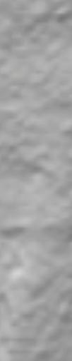
3 INTRODUCTION Martin, M., Commonwealth Glacier, Dry Valleys, Digital Image, Oceanwide Expeditions 3
4 IMPORTANCE OF CHANNEL GEOMORPHOLOGY IN TAYLOR VALLEY New methods are needed McMurdo Dry Valleys (MDV) are remote and expensive Short summer months = insufficient data Provides information on regional climate change Precipitation is minimal (<100 mm/yr) Runoff is temperature dependent 4
: U.S.")
5 U.S. Geological Survey, 2007, Landsat Image Mosaic of Antarctica (LIMA): U.S. Geological Survey Fact Sheet , 4 p. 5
6 DEM DATASETS 2001 dataset: NASA, Airborne Topographic Mapper (ATM) 0.37 points/m 2 (1 point/2.7 m 2 ) 2014 dataset: NCALM, Optech Titan Sensor 5-10 points/m 2 (>10x avg. point density!) Point clouds resampled to a 1x1 meter DEM 6


. 77 35 08.")


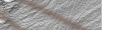
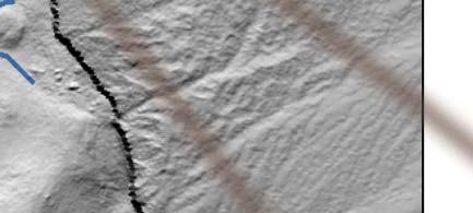
7 SITE 1, LOST SEAL STREAM Google earth V (January 17, 2010) S, E, Eye alt 1.37 km. DigitalGlobe [November 30, 2017] 7


8 SITE 1, LOST SEAL STREAM Photo taken by Darren Hauser 8
. 77 35 23.")

9 SITE 2 Google earth V (January 17, 2010) S, E, Eye alt 915 feet. DigitalGlobe [November 30, 2017] 9
, A Geometric Framework for Channel Extraction from LiDAR: Nonlinear diffusion and geodesic paths, Journal of Geophysical Research, vol.")
10 GEONET 2.2 Used for automatic extraction of channel networks (Passalacqua, P. et al., 2010) Passalacqua, P., Trung, T.D., Foufoula-Georgiou, E., Guillermo, S., and Dietrich, W.E. (2010), A Geometric Framework for Channel Extraction from LiDAR: Nonlinear diffusion and geodesic paths, Journal of Geophysical Research, vol. 115, F01002, 18 p. 10

11 CHANNEL MIGRATION TOOLBOX Measures average lateral channel migration (Legg, N.T., et al., 2014) Legg, N.T., Heimburg, C., Collins, B.D., and Olson, P.L. (2014), The Channel Migration Toolbox: ArcGIS Tools for Measuring Stream Channel Migration, Department of Ecology State of Washington, no , 14 p. 11


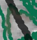
12 12


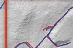
13 Migration Stream Loss Stream Growth 13
14 14


15 Stream Growth Migration Stream Loss 15


16 LAW OF V S AND CROSS SECTION QUALITY CHECK 16
17 AVERAGE CHANNEL MIGRATION - SITE 1 Average Channel Migration Channel Number Channel Migration Area (m 2 ) Average Channel Migration (m) Channel 2001 Channel Migration Area


18 AVERAGE CHANNEL MIGRATION SITE 1 ile 6 Profile Proffilile 5 Channel m Channel m Not to Scale 1 ile 10b roffile Pro P e 11 offiile Prro Channel m Channel m 2014 Channel 2001 Channel Migration Area e6 offilile Pro Profile 5 18

19 Channel Number SITE 1- STREAM COMPLEXITY Change in Total Number Total Number Channel Channel of Channel of Length Length (m) Branches Length (m) Branches (m) Change in # of Branches Total (+2.3%) (-10%) 19
 1 1606.7 6.6 3 287.3 0.6 6 515.4 1.3 2014 Channel 2001 Channel Migration Area 7 153.4 0.9 8 860.")
20 AVERAGE CHANNEL MIGRATION SITE 2 Average Channel Migration Channel Number Channel Migration Area (m 2 ) Average Channel Migration (m) Channel 2001 Channel Migration Area


21 AVERAGE CHANNEL MIGRATION SITE 2 Channel m Channel m Channel m Channel m Channel m 21
22 RESULTS: SITE 2- STREAM COMPLEXITY Channel Number Total Channel Length (m) Number of Branches Total Channel Length (m) Number of Branches Change in Channel Length (m) Change in # of Branches Total (+4.8%) (+23.5%) 22
 217.4 (+4.8%) Change of Number of Branches -6 (-10%) 12 (+23.")
23 RESULTS: STREAM COMPLEXITY COMPARISON Channel Year Site 1 Site 2 Change of Channel Length (m) (+2.3%) (+4.8%) Change of Number of Branches -6 (-10%) 12 (+23.5%) 2014 Channel 2001 Channel 23
24 CONCLUSIONS GeoNet is an efficient alternative to manual extraction of channel networks Low migration rates due to hyper-arid cold, polar desert climate Site 1 had decrease in channels. Site 2 had an increase in channels Lengthening of channels in Site 1 and 2 May not represent the whole MDV 24


25 Extract networks for the entire valley Automate channel migration Additional Analyses: 1. Slope 2. Microclimate Zones 3. Outcrop Geology 4. Soil Salinity 5. Soil Temperatures FUTURE WORK Photo taken by Darren Hauser 25
26 REFERENCES Csatho, B., Schenk, T., Krabill, W., Wilson, T., Lyons, W., McKenzie, G., Hallam, C., Manizade, S., and Paulsen, T. (2005), Airborne Laser Scanning for High-Resolution Mapping of Antarctica, Eos Trans. AGU, vol. 86, no. 25, pp Doran, P.T., McKay, C.P., Clow, G.D., Dana, G.L., Fountain, A.G., Nylen, T., and Lyons, W.B. (2002), Journal of Geophysical Research, vol. 107, no. D24, 4772, 12 p. Fountain, A.G., Nylen, T.H., MacClune, K.L. and Gayle, L.D. (2006), Glacier Mass Balances ( ), Taylor Valley, McMurdo Dry Valleys, Antarctica, Journal of Glaciology, vol. 52, no. 178, pp Hoffman, M.J. (2011), Spatial Temporal Variability of Glacier Melt in the McMurdo Dry Valleys, Antarctica, Portland State University, PDX Scholar, 296 p. Hoffman, M.J., Fountain, A.G., and Liston, G.E. (2008), Surface Energy balance and melt thresholds over 11 years at Taylor Glacier, Antarctica, Journal of Geophysical Research, vol. 113, F04014, 12 p. Lashermes, B., Foufoula-Georgiou, E., Dietrich, W.E. (2007), Channel network extraction from high resolution topography using wavelets, Geophysical Research Letters, vol. 34, L23S04, 6 p. Legg, N.T., Heimburg, C., Collins, B.D., and Olson, P.L. (2014), The Channel Migration Toolbox: ArcGIS Tools for Measuring Stream Channel Migration, Department of Ecology State of Washington, no , 14 p. Marchant, D.R. and Head, J.W. III (2007), Antarctica Dry Valleys: Microclimate Zonation, Variable Geomorphic Processes, and Implication for Assessing Climate Change on Mars, Elsevier, Icarus, vol. 192, pp Markshack, S. and Mitra, G. (1988), Basic Methods of Structural Geology, Prentice Hall, 464 p. Palumbo, A.M. and Head, J.W. (2017), An Analysis of Seasonal Temperature Variation in the Antarctic McMurdo Dry Valleys: Implications for Early Martian Climate and Valley Network Formation, Lunar and Planetary Science XL VIII, 2 p. Passalacqua, P., Trung, T.D., Foufoula-Georgiou, E., Guillermo, S., and Dietrich, W.E. (2010), A Geometric Framework for Channel Extraction from LiDAR: Nonlinear diffusion and geodesic paths, Journal of Geophysical Research, vol. 115, F01002, 18 p. 26

27 QUESTIONS Photo taken by Darren Hauser 27
A Novel Approach to Measuring Glacier Motion Remotely using Aerial LiDAR
 A Novel Approach to Measuring Glacier Motion Remotely using Aerial LiDAR JENNIFER TELLING, ANDREW FOUNTAIN, CRAIG GLENNIE, MACIEK OBRYK AGU FALL MEETING, DECEMBER 14, 2016 C34C-07 Study Area Taylor Valley,
Geomorphologic Mapping by Airborne Laser Scanning in Southern Victoria Land
 Geomorphologic Mapping by Airborne Laser Scanning in Southern Victoria Land Bea Csatho, Terry Wilson, Tony Schenk, Garry McKenzie, Byrd Polar Research Center, The Ohio State University, Columbus, OH William
Lidar data in water resources applications. Paola Passalacqua CE 374K Lecture, April 5 th, 2012
 Lidar data in water resources applications Paola Passalacqua CE 374K Lecture, April 5 th, 2012 Airborne Lidar Airborne laser altimetry technology (LiDAR, Light Detection And Ranging) provides high-resolution
Geomorphologic Mapping by Airborne Laser Scanning in the Antarctic Dry Valleys. Bea Csatho and Tony Schenk The Ohio State University, Columbus, OH
 Geomorphologic Mapping by Airborne Laser Scanning in the Antarctic Dry Valleys Bea Csatho and Tony Schenk The Ohio State University, Columbus, OH Outline Overview of airborne laser mapping and polar applications
GIS feature extraction tools in diverse landscapes
 CE 394K.3 GIS in Water Resources GIS feature extraction tools in diverse landscapes Final Project Anna G. Kladzyk M.S. Candidate, Expected 2015 Department of Environmental and Water Resources Engineering
Lidar data in water resources applications
 Lidar data in water resources applications Paola Passalacqua CE 394K 3 Guest Lecture, November 15 th, 2012 Airborne Lidar Airborne laser altimetry technology (lidar, Light Detection And Ranging) provides
Presentation given at Smithsonian National Air and Space Museum October 2006
 Presentation given at Smithsonian National Air and Space Museum October 2006 The Science and Art of Mapping Martian Valley Networks Using a Computer Algorithm Tomasz F. Stepinski Lunar and Planetary Institute
Publications. In Press
 Publications. In Press Levy, J.S., Fountain, A.G., O Connor, J.E., Welch, K.A., and Lyons, W.B., Garwood Valley, Antarctica: A new record of last glacial maximum to Holocene glacio-fluvial processes from
Terrain Analysis of Taylor Valley, McMurdo Dry Valleys, Antarctica Logan Schmidt, University of Texas Institute for Geophysics.
 Terrain Analysis of Taylor Valley, McMurdo Dry Valleys, Antarctica Logan Schmidt, University of Texas Institute for Geophysics Abstract The surface geology of Taylor Valley records information about the
The McMurdo Dry Valleys of Antarctica: harshest place on Earth or a polar oasis?
 LIVE INTERACTIVE LEARNING @ YOUR DESKTOP The McMurdo Dry Valleys of Antarctica: harshest place on Earth or a polar oasis? Presented by: Dr. Cristina Vesbach, Dr. Michael Gooseff, and Dr. Jeb Barrett Thursday,
ANALYSIS OF GLACIER CHANGE IN THE SIERRA NEVADA PORTLAND STATE UNIVERSITY DEPARTMENT OF GEOLOGY BRADLEY BUSELLI
 ANALYSIS OF GLACIER CHANGE IN THE SIERRA NEVADA PORTLAND STATE UNIVERSITY DEPARTMENT OF GEOLOGY BRADLEY BUSELLI Study area: Sierra Nevada (Glaciers, 2015) Closer look (Glaciers, 2015) Primary goal: Research
Hydrologic Response to Extreme Warm and Cold Summers in the McMurdo Dry Valleys, East Antarctica
 Portland State University PDXScholar Geography Faculty Publications and Presentations Geography 1-1-2008 Hydrologic Response to Extreme Warm and Cold Summers in the McMurdo Dry Valleys, East Antarctica
Hydrologic response to extreme warm and cold summers in the McMurdo Dry Valleys, East Antarctica
 Antarctic Science page 1 of 11 (2008) & Antarctic Science Ltd 2008 doi: 10.1017/S0954102008001272 1 2 3 4 5 6 7 8 9 10 11 12 13 14 15 16 17 18 19 20 21 22 23 24 25 26 27 28 29 30 31 32 33 34 35 36 37 38
SNOW DYNAMICS IN A POLAR DESERT, MCMURDO DRY VALLEYS, ANTARCTICA
 The Pennsylvania State University The Graduate School College of Engineering SNOW DYNAMICS IN A POLAR DESERT, MCMURDO DRY VALLEYS, ANTARCTICA A Thesis in Civil Engineering by Jeffery W. Eveland 2012 Jeffery
Thermal Dynamics of the Active Layer Along a Hydrologic Gradient Bordering Lakes in the McMurdo Dry Valleys, Antarctica
 Thermal Dynamics of the Active Layer Along a Hydrologic Gradient Bordering s in the McMurdo Dry Valleys, Antarctica Michael N. Gooseff Department of Civil & Environmental Engineering, Pennsylvania State
MCMURDO DRY VALLEYS ANTARCTICA
 POLAR WEEKEND MCMURDO DRY VALLEYS ANTARCTICA TOPIC: The McMurdo Dry Valleys, An Ecosystem of microbial life PROJECT PERSONNEL: Dr. Andrew G. Fountain, Geologist, Portland State University, Portland Oregon
Terrain and Satellite Imagery in Madre de Dios, Peru
 Rhett Butler/mongabay.com Terrain and Satellite Imagery in Madre de Dios, Peru Katherine Lininger CE 394 GIS for Water Resources Term Paper December 1, 2011 Introduction Informal and small-scale gold mining
Civil Engineering Journal
 Available online at www.civilejournal.org Civil Engineering Journal Vol. 1, No. 2, December, 2015 Comparative Study of Landsat and Aster Data by Morphometric Analysis Sujit Kumar a*, Tapasi Bhandary b
38 Antarctic Dry Valleys:
 38 Antarctic Dry Valleys: 1. The Antarctic environment and the Antarctic Dry Valleys. 2. Cold-based glaciers and their contrast with wet-based glaciers. 3. Microclimate zones in the Antarctic Dry Valleys
Presentation given to computer science undergraduate students at the University of Houston July 2007
 Presentation given to computer science undergraduate students at the University of Houston July 2007 Machine Learning and Data Mining in Mars Tomasz F. Stepinski Lunar and Planetary Institute MARS/EARTH
Automated Identification and Characterization of Landforms on Mars
 Automated Identification and Characterization of Landforms on Mars Tomasz F. Stepinski Lunar and Planetary Institute Collaborators: Wei Luo Students: Brain Bue Ian Molloy Erik Urbach Michael Mendenhall
Using Remote Sensing to Analyze River Geomorphology
 Using Remote Sensing to Analyze River Geomorphology Seeing Water from Space Workshop August 11 th, 2015 George Allen geoallen@unc.edu Rivers impact: Geology Ecology Humans The atmosphere River Geomorphology
GIS based Estimation of snow depth in mountainous Himalayan region: A case study
 GIS based Estimation of snow depth in mountainous Himalayan region: A case study Chander Shekhar *1, S K Dewali *, Snehmani * * Snow and Avalanche Study Establishment, Chandigarh, India 160036, India 1
Antarctica & Greenland, Theory & Observations
 Ocean-Ice Interactions: Antarctica & Greenland, Theory & Observations Keck Institute for Space Studies September 9, 2013 David HOLLAND New York University + Abu Dhabi 0 Overview: Ocean-Ice Interface Delivery
Applications of GIS in assessing Coastal Change Rachel Hehre November 30, 2004 NRS 509 OVERVIEW
 Applications of GIS in assessing Coastal Change Rachel Hehre November 30, 2004 NRS 509 OVERVIEW ITRODUCTION Due to the dynamic nature of coastal systems, representing coastal change with precision and
Height Above Nearest Drainage in Houston THE UNIVERSITY OF TEXAS AT AUSTIN
 Height Above Nearest Drainage in Houston THE UNIVERSITY OF TEXAS AT AUSTIN Jeff Yuanhe Zheng GIS in Water Resources December 2 nd, 2016 Table of Contents 1.0 Introduction... 1 2.0 Project Objective...
Testing space scale methodologies for automatic geomorphic feature extraction from lidar in a complex mountainous landscape
 WATER RESOURCES RESEARCH, VOL. 46,, doi:10.1029/2009wr008812, 2010 Testing space scale methodologies for automatic geomorphic feature extraction from lidar in a complex mountainous landscape Paola Passalacqua,
Chapter 5 LiDAR Survey and Analysis in
 Chapter 5 LiDAR Survey and Analysis in 2010-2011 Christopher Fennell A surveyor s plat and town plan filed in 1836 set out an intended grid of blocks, lots, alleys, and streets for New Philadelphia. Geophysical,
Seasonal controls on snow distribution and aerial ablation at the snow-patch and landscape scales, McMurdo Dry Valleys, Antarctica
 ess doi:10.5194/tc-7-917-2013 Author(s) 2013. CC Attribution 3.0 License. The Cryosphere Open Access Seasonal controls on snow distribution and aerial ablation at the snow-patch and landscape scales, McMurdo
Robotic Site Survey for ISRU
 NASA Ames Research Center Maria Bualat Intelligent Robotics Group Maria.Bualat@nasa.gov Outline Site Survey Overview GPR Survey Hydrogen Prospecting 2 Human-Robot Site Survey Project Systematic survey
Spatial modelling of wetness for the Antarctic Dry Valleys
 RESEARCH/REVIEW ARTICLE Spatial modelling of wetness for the Antarctic Dry Valleys Glen Stichbury 1, Lars Brabyn 1, T.G. Allan Green 2 & Craig Cary 2 1 Department of Geography, Tourism and Environmental
The History of Water on Mars: Synthesis of New Results from Valley Networks and Deltas
 The History of Water on Mars: Synthesis of New Results from Valley Networks and Deltas Brian M. Hynek Professor at the University of Colorado, Laboratory for Atmospheric and Space Physics Department of
Using High-Resolution Commercial Imagery in the Geosciences
 Using High-Resolution Commercial Imagery in the Geosciences George Roth Geospatial Support Specialist 2015 AGU Student & Early Career Scientist Conference San Francisco, CA December 13th, 2015 The Geoscience
THESIS APPROVAL. The abstract and thesis of Amy Francis Ebnet for the Master of Science in Geology. COMMITTEE APPROVALS: Andrew G.
 THESIS APPROVAL The abstract and thesis of Amy Francis Ebnet for the Master of Science in Geology were presented October 3, 5, and accepted by the thesis committee and the department. COMMITTEE APPROVALS:
Change detection at the recently erupted Te Maari crater, Tongariro, from stereo aerial photographs
 Change detection at the recently erupted Te Maari crater, Tongariro, from stereo aerial photographs Strong, D.T., Jones, K.E., Ashraf, S. and Lee, J. Outline Geographic context Setting and eruption Science
Exam II: Water, Winds, Deserts, Oceans
 Montclair State University, College of Science and Mathematics Department of Earth and Environmental Studies EAES101 Planet Earth Semester: SAMPLE Dr. Mark Chopping Exam II: Water, Winds, Deserts, Oceans
Hydrological feature extraction from LiDAR. Grant Pearse 28 March 2017
 Hydrological feature extraction from LiDAR Grant Pearse 28 March 2017 Overview Hydrology and Forestry Background & Motivation Extract more value from LiDAR Case study Geraldine Practical Overview Hydrology
PERMAFROST PROPERTIES IN THE McMURDO SOUNDÐDRY VALLEY REGION OF ANTARCTICA
 PERMAFROST PROPERTIES IN THE McMURDO SOUNDÐDRY VALLEY REGION OF ANTARCTICA I.B. Campbell 1 ; G.G.C. Claridge 1 ; D.I. Campbell 2, M.R. Balks 2 1. Land and Soil Consultancy; 23 View Mount, Nelson 7001 New
Defining microclimates on Long Island using interannual surface temperature records from satellite imagery
 Defining microclimates on Long Island using interannual surface temperature records from satellite imagery Deanne Rogers*, Katherine Schwarting, and Gilbert Hanson Dept. of Geosciences, Stony Brook University,
Structure from Motion Photogrammetry for 3D Reconstruction of Crater Glacier on Mount St. Helens, Washington, USA
 Julian Cross GEOG 593 Department of Geography Portland State University 12/5/16 Structure from Motion Photogrammetry for 3D Reconstruction of Crater Glacier on Mount St. Helens, Washington, USA Abstract:
SECTION 2 How Is Pacific Northwest Climate Changing?
 SECTION 2 How Is Pacific Northwest Climate Changing? The Pacific Northwest is experiencing a suite of long-term changes that are consistent with those observed globally as a result of human-caused climate
THE NEW GEOLOGY OF MARS: TOP TEN RESULTS OF POST-VIKING GLOBAL MAPPING AND CRATER-DATING
 THE NEW GEOLOGY OF MARS: TOP TEN RESULTS OF POST-VIKING GLOBAL MAPPING AND CRATER-DATING K.L. Tanaka 1, J.A. Skinner, Jr. 1, C.M. Fortezzo 1, T.M. Hare 1, R.P. Irwin 2, T. Platz 3, G. Michael 3, J.M. Dohm
PHASE 1 STUDIES UPDATE EROSION WORKING GROUP
 PHASE 1 STUDIES UPDATE EROSION WORKING GROUP Presented By MICHAEL WOLFF, PG Erosion Study Area Manager West Valley Demonstration Project Quarterly Public Meeting February 24, 2016 OUTLINE Study 1 Terrain
Sea Level Rise and the Scarborough Marsh Scarborough Land Trust Annual Meeting April 24, 2018
 Sea Level Rise and the Scarborough Marsh Scarborough Land Trust Annual Meeting April 24, 2018 Peter A. Slovinsky, Marine Geologist Maine Geological Survey Funded by: 50% 40% Figure modified from Griggs,
Measuring earthquake-generated surface offsets from high-resolution digital topography
 Measuring earthquake-generated surface offsets from high-resolution digital topography July 19, 2011 David E. Haddad david.e.haddad@asu.edu Active Tectonics, Quantitative Structural Geology, and Geomorphology
Digital Elevation Models (DEM)
") Digital Elevation Models (DEM) Digital representation of the terrain surface enable 2.5 / 3D views Rule #1: they are models, not reality Rule #2: they always include some errors (subject to scale and data
Digital Elevation Models (DEM) Digital representation of the terrain surface enable 2.5 / 3D views Rule #1: they are models, not reality Rule #2: they always include some errors (subject to scale and data
TEACHER PAGE Trial Version
 TEACHER PAGE Trial Version * After completion of the lesson, please take a moment to fill out the feedback form on our web site (https://www.cresis.ku.edu/education/k-12/online-data-portal)* Lesson Title:
ESTIMATING SNOWMELT CONTRIBUTION FROM THE GANGOTRI GLACIER CATCHMENT INTO THE BHAGIRATHI RIVER, INDIA ABSTRACT INTRODUCTION
 ESTIMATING SNOWMELT CONTRIBUTION FROM THE GANGOTRI GLACIER CATCHMENT INTO THE BHAGIRATHI RIVER, INDIA Rodney M. Chai 1, Leigh A. Stearns 2, C. J. van der Veen 1 ABSTRACT The Bhagirathi River emerges from
IMPACT OF CLIMATE CHANGE OVER THE ARABIAN PENINSULA
 IMPACT OF CLIMATE CHANGE OVER THE ARABIAN PENINSULA By: Talal Alharbi June, 29 2017 1 Motivation: In arid and semi-arid regions of the world the demand for fresh water resources is increasing due to: increasing
Brita Horlings
 Knut Christianson Brita Horlings brita2@uw.edu https://courses.washington.edu/ess431/ Natural Occurrences of Ice: Distribution and environmental factors of seasonal snow, sea ice, glaciers and permafrost
Governing Rules of Water Movement
 Governing Rules of Water Movement Like all physical processes, the flow of water always occurs across some form of energy gradient from high to low e.g., a topographic (slope) gradient from high to low
Characterization of Catchments Extracted From. Multiscale Digital Elevation Models
 Applied Mathematical Sciences, Vol. 1, 2007, no. 20, 963-974 Characterization of Catchments Extracted From Multiscale Digital Elevation Models S. Dinesh Science and Technology Research Institute for Defence
MARS STUDENT IMAGING PROJECT FINAL REPORT ASU MARS EDUCATION PROGRAM Waubonsie Valley High School Period School Year
 I. Introduction What is your science question? What effect do the polar ice caps have on craters in the rock strata? Why is this question important and interesting? This question is important for the following
Grade 8 Science. Unit 1: Water Systems on Earth Chapter 1
 Grade 8 Science Unit 1: Water Systems on Earth Chapter 1 Effects of Water? Churchill River Large Ocean Wave How do you use water? House Hold Use Personal Use Recreational Activities Water Distribution
USING GIS CARTOGRAPHIC MODELING TO ANALYSIS SPATIAL DISTRIBUTION OF LANDSLIDE SENSITIVE AREAS IN YANGMINGSHAN NATIONAL PARK, TAIWAN
 CO-145 USING GIS CARTOGRAPHIC MODELING TO ANALYSIS SPATIAL DISTRIBUTION OF LANDSLIDE SENSITIVE AREAS IN YANGMINGSHAN NATIONAL PARK, TAIWAN DING Y.C. Chinese Culture University., TAIPEI, TAIWAN, PROVINCE
 Mission to Mars: Project Based Learning Water on Mars Dr. Anthony Petrosino, Department of Curriculum and Instruction, College of Education, University of Texas at Austin Benchmarks content author: Elisabeth
Breakout Session III Evolving landscapes and global environmental change
 Breakout Session III Evolving landscapes and global environmental change 1. Hydrology and critical zone imaging 2. Glaciology: Instrumenting glaciers and ice sheets 3. Polar networks and glacial isostatic
Fundamentals of THE PHYSICAL ENVIRONMENT. David Briggs, Peter Smithson, Kenneth Addison and Ken Atkinson
 Fundamentals of THE PHYSICAL ENVIRONMENT Second Edition David Briggs, Peter Smithson, Kenneth Addison and Ken Atkinson LONDON AND NEW YORK Contents L,ISI Of colour piates List of black and white plates
A Temporal Hydrologic Database for Rapidly Changing Landscapes
 A Temporal Hydrologic Database for Rapidly Changing Landscapes Using Mt. St. Helens in Washington as a Pilot Site Adam Mosbrucker Geog 575 BACKGROUND: Client / User U.S. Geological Survey Cascades Volcano
Supplementary Fig. 1. Locations of thinning transects and photos of example samples. Mt Suess/Gondola Ridge transects extended metres above
 Supplementary Fig. 1. Locations of thinning transects and photos of example samples. Mt Suess/Gondola Ridge transects extended 260 24 metres above the modern surface of Mackay Glacier, and included 16
Hydrologically Consistent Pruning of the High- Resolution National Hydrography Dataset to 1:24,000-scale
 Hydrologically Consistent Pruning of the High- Resolution National Hydrography Dataset to 1:24,000-scale Lawrence V. Stanislawski 1, Ariel Doumbouya 2, Barbara P. Buttenfield 3, 1 Center for Excellence
A physical mechanism for long-term survival of ground ice in Beacon Valley, Antarctica
 GEOPHYSICAL RESEARCH LETTERS, VOL. 32, L19503, doi:10.1029/2005gl023881, 2005 A physical mechanism for long-term survival of ground ice in Beacon Valley, Antarctica Norbert Schorghofer NASA Astrobiology
GROUNDWATER CONFIGURATION IN THE UPPER CATCHMENT OF MEGHADRIGEDDA RESERVOIR, VISAKHAPATNAM DISTRICT, ANDHRA PRADESH
 GROUNDWATER CONFIGURATION IN THE UPPER CATCHMENT OF MEGHADRIGEDDA RESERVOIR, VISAKHAPATNAM DISTRICT, ANDHRA PRADESH Prof.P.Jagadeesara Rao Department of Geo-Engineering and Centre for Remote Sensing, College
Glacial Modification of Terrain
 Glacial Modification Part I Stupendous glaciers and crystal snowflakes -- every form of animate or inanimate existence leaves its impress upon the soul of man. 1 -Orison Swett Marden Glacial Modification
FROM CRYOSPHERE TO ANTHROPOGENIC IMPACTS
 FROM CRYOSPHERE Balázs Nagy Department of Physical Geography Eötvös Loránd University, Budapest TO ANTHROPOGENIC IMPACTS primary data and environmental applications: - summary of the Hungarian high altitude
Modelling runoff from large glacierized basins in the Karakoram Himalaya using remote sensing of the transient snowline
 Remote Sensing and Hydrology 2000 (Proceedings of a symposium held at Santa Fe, New Mexico, USA, April 2000). IAHS Publ. no. 267, 2001. 99 Modelling runoff from large glacierized basins in the Karakoram
Create a Topographic Profile of Beacon Valley
 Details Create a Topographic Profile of Beacon Valley Completion Time: About a week Permission: Download, Share, and Remix Overview Beacon Valley is recognized by scientists as one of the most Mars-like
Outcrop suitability analysis of blueschists within the Dry Lakes region of the Condrey Mountain Window, North-central Klamaths, Northern California
 Outcrop suitability analysis of blueschists within the Dry Lakes region of the Condrey Mountain Window, North-central Klamaths, Northern California (1) Introduction: This project proposes to assess the
Thomas P. Phillips CIRES Prof K. Steffen, L. Colgan PhD ABD, D. McGrath MA
 Thomas P. Phillips CIRES Prof K. Steffen, L. Colgan PhD ABD, D. McGrath MA Problem: we know very little about the processes happening within the Greenland Ice Sheet. What is the velocity at the base? What
APPLICATION OF AIRCRAFT LASER ALTIMETRY TO GLACIER AND ICE CAP MASS BALANCE STUDIES
 APPLICATION OF AIRCRAFT LASER ALTIMETRY TO GLACIER AND ICE CAP MASS BALANCE STUDIES W. Abdalati and W.B. Krabill Laboratory for Hydrospheric Processes NASA Goddard Space Flight Center U.S.A. waleed.abdalati@gsfc.nasa.gov
Education. Research Synopsis
 Joseph S. Levy NSF Polar Regions Research Postdoctoral Fellow Portland State University Department of Geology, Portland, OR Tel: 773.909.8950 / 503.725.3355 Email: jlevy@pdx.edu Education B.S. Geophysical
Climate Regimes of the Arctic
 Climate Regimes of the Arctic The climate of Greenland, recent changes and the ice sheet mass balance Map of Greenland, showing elevation and the location of GC- Net automatic weather stations (+), expedition
MAPPING OF THE MICRORELIEF STRUCTURES USING TOPOGRAPHIC DATA
 MAPPING OF THE MICRORELIEF STRUCTURES USING TOPOGRAPHIC DATA DOI: https://doi.org/10.18509/agb.2018.03 UDK: 528.93.06(470) Evgeny Panidi 1, Lubov Trofimetz 2, Julia Sokolova 1, Elena Kunaeva 1, 3 1 Saint
Using Earthscope and B4 LiDAR data to analyze Southern California s active faults
 Using Earthscope and B4 LiDAR data to analyze Southern California s active faults Exercise 8: Simple landscape morphometry and stream network delineation Introduction This exercise covers sample activities
AMAP. Climate Change in the Cryosphere: Snow, Water, Ice and Permafrost in the Arctic (SWIPA) Assessment Summary
 Assessment Summary") Cooperative Institute for Research in Environmental Sciences University of Colorado AMAP Climate Change in the Cryosphere: Snow, Water, Ice and Permafrost in the Arctic (SWIPA) Assessment Summary Arctic
Cooperative Institute for Research in Environmental Sciences University of Colorado AMAP Climate Change in the Cryosphere: Snow, Water, Ice and Permafrost in the Arctic (SWIPA) Assessment Summary Arctic
HYDROLOGIC AND WATER RESOURCES EVALUATIONS FOR SG. LUI WATERSHED
 HYDROLOGIC AND WATER RESOURCES EVALUATIONS FOR SG. LUI WATERSHED 1.0 Introduction The Sg. Lui watershed is the upper part of Langat River Basin, in the state of Selangor which located approximately 20
It s a Model. Quantifying uncertainty in elevation models using kriging
 It s a Model Quantifying uncertainty in elevation models using kriging By Konstantin Krivoruchko and Kevin Butler, Esri Raster based digital elevation models (DEM) are the basis of some of the most important
Freshwater. 1. The diagram below is a cross-sectional view of rain falling on a farm field and then moving to the water table.
 Name: ate: 1. The diagram below is a cross-sectional view of rain falling on a farm field and then moving to the water table. 3. Which conditions produce the most surface water runoff? A. steep slope,
Climate Regions. Combining Climate Graphs and Köppen s Classification
 Lab 15 Climate Regions Combining knowledge of the global patterns behind the major climatic controls, this lab will teach students how to construct climate graphs and then allow them to explore patterns
Introduction. in this web service Cambridge University Press PETER T. DORAN, W. BERRY LYONS, AND DIANE M. M CKNIGHT
 1 Introduction PETER T. DORAN, W. BERRY LYONS, AND DIANE M. M CKNIGHT The dry valleys of East Antarctica are at first glance a barren landscape. This was certainly Robert Falcon Scott s impression when
Geoscience Australia Report on Cal/Val Activities
 Medhavy Thankappan Geoscience Australia Agency Report I Berlin May 6-8, 2015 Outline 1. Calibration / validation at Geoscience Australia Corner reflector infrastructure for SAR calibration (for information)
Lidar-derived Hydrography as a Source for the National Hydrography Dataset
 Lidar-derived Hydrography as a Source for the National Hydrography Dataset Lidar-Derived Hydrography, Bathymetry, and Topobathymetry in the National Hydrography Dataset and 3-Dimensional Elevation Program
Automatic geomorphic feature extraction from lidar in flat and engineered landscapes
 WATER RESOURCES RESEARCH, VOL. 48, W03528, doi:10.1029/2011wr010958, 2012 Automatic geomorphic feature extraction from lidar in flat and engineered landscapes Paola Passalacqua, 1 Patrick Belmont, 2 and
Background. Points of Discussion. Hydrographic Models
 Airborne Laser Remote Sensing Technology: Providing Essential Hydrologic Information in the 21 st Century Warwick Hadley, Optech Incorporated Presented by: Warwick Hadley Sales Manager, Middle East and
The Climate of Oregon Climate Zone 4 Northern Cascades
 /05 E55 Unbound issue No. 9/ is Does not circulate Special Report 916 May 1993 The Climate of Oregon Climate Zone 4 Property of OREGON STATE UNIVERSITY Library Serials Corvallis, OR 97331-4503 Agricultural
38, Tripoleos Str., Athens , Greece, 23, Velvedou Str., Athens , Greece,
 A Feature Based Accuracy Evaluation of GTOPO30 Miliaresis, G. Ch 1 & Paraschou, C. V. E. 2 Remote Sensing Laboratory, National Technical University of Athens, 1 38, Tripoleos Str., Athens 104-42, Greece,
Cell Size Dependence of Threshold Conditions for the Delineation of Drainage Networks from Gridded Elevation Data
 Proceedings of Geomorphometry. Zurich, Switzerland, August - September, Cell Size Dependence of Threshold Conditions for the Delineation of Drainage Networks from Gridded Elevation Data P. Tarolli, G.
Drainage Density and Controlling Factors in Cascade Range, Oregon, USA
 Drainage Density and Controlling Factors in Cascade Range, Oregon, USA Wei Luo *a, Tomasz Stepinski b, and Yi Qi a a Department of Geography, Northern Illinois University, DeKalb, IL 60115, USA; b Lunar
RR#5 - Free Response
 Base your answers to questions 1 through 3 on the data table below and on your knowledge of Earth Science. The table shows the area, in million square kilometers, of the Arctic Ocean covered by ice from
Digital Elevation Models. Using elevation data in raster format in a GIS
 Digital Elevation Models Using elevation data in raster format in a GIS What is a Digital Elevation Model (DEM)? Digital representation of topography Model based on scale of original data Commonly a raster
Product Validation Report Polar Ocean
 Product Validation Report Polar Ocean Lars Stenseng PVR, Version 1.0 July 24, 2014 Product Validation Report - Polar Ocean Lars Stenseng National Space Institute PVR, Version 1.0, Kgs. Lyngby, July 24,
Watershed Delineation in GIS Environment Rasheed Saleem Abed Lecturer, Remote Sensing Centre, University of Mosul, Iraq
 Watershed Delineation in GIS Environment Rasheed Saleem Abed Lecturer, Remote Sensing Centre, University of Mosul, Iraq Abstract: The management and protection of watershed areas is a major issue for human
KINEROS2/AGWA. Fig. 1. Schematic view (Woolhiser et al., 1990).
.") KINEROS2/AGWA Introduction Kineros2 (KINematic runoff and EROSion) (K2) model was originated at the USDA-ARS in late 1960s and released until 1990 (Smith et al., 1995; Woolhiser et al., 1990). The spatial
KINEROS2/AGWA Introduction Kineros2 (KINematic runoff and EROSion) (K2) model was originated at the USDA-ARS in late 1960s and released until 1990 (Smith et al., 1995; Woolhiser et al., 1990). The spatial
Desertification Hazard Zonation by Means of ICD Method in Kouhdasht Watershed
 DESERT DESERT Online at http://jdesert.ut.ac.ir DESERT 17 (13) 233240 Desertification Hazard Zonation by Means of ICD Method in Kouhdasht Watershed Gh. Chamanpira a*, Gh.R. Zehtabian b, H. Ahmadi c, M.
GEOGRAPHY (029) CLASS XI ( ) Part A: Fundamentals of Physical Geography. Map and Diagram 5. Part B India-Physical Environment 35 Marks
 CLASS XI ( ) Part A: Fundamentals of Physical Geography. Map and Diagram 5. Part B India-Physical Environment 35 Marks") GEOGRAPHY (029) CLASS XI (207-8) One Theory Paper 70 Marks 3 Hours Part A Fundamentals of Physical Geography 35 Marks Unit-: Geography as a discipline Unit-3: Landforms Unit-4: Climate Unit-5: Water (Oceans)
GEOGRAPHY (029) CLASS XI (207-8) One Theory Paper 70 Marks 3 Hours Part A Fundamentals of Physical Geography 35 Marks Unit-: Geography as a discipline Unit-3: Landforms Unit-4: Climate Unit-5: Water (Oceans)
APPLICATIONS OF DOWNSCALING: HYDROLOGY AND WATER RESOURCES EXAMPLES
 APPLICATIONS OF DOWNSCALING: HYDROLOGY AND WATER RESOURCES EXAMPLES Dennis P. Lettenmaier Department of Civil and Environmental Engineering For presentation at Workshop on Regional Climate Research NCAR
ECVs: What s operational and what still requires R&D?
 Glaciers_cci input on ECVs: What s operational and what still requires R&D? Frank Paul* Department of Geography, University of Zurich *on behalf of the Glaciers_cci consortium Google Earth Operational
USING HYPERSPECTRAL IMAGERY
 USING HYPERSPECTRAL IMAGERY AND LIDAR DATA TO DETECT PLANT INVASIONS 2016 ESRI CANADA SCHOLARSHIP APPLICATION CURTIS CHANCE M.SC. CANDIDATE FACULTY OF FORESTRY UNIVERSITY OF BRITISH COLUMBIA CURTIS.CHANCE@ALUMNI.UBC.CA
Snow cover monitoring and modelling in the Alps using multi temporal MODIS data
 cover monitoring and modelling in the Alps using multi temporal MODIS data Rastner P. 1, Irsara L. 1, Schellenberger T. 1, Della Chiesa S. 2, Bertoldi G. 2, Endrizzi S. 3, Notarnicola C. 1 and Zebisch
MONITORING OF SEASONAL SNOW COVER IN YAMUNA BASIN OF UTTARAKAHND HIMALAYA USING REMOTE SENSING TECHNIQUES
 MONITORING OF SEASONAL SNOW COVER IN YAMUNA BASIN OF UTTARAKAHND HIMALAYA USING REMOTE SENSING TECHNIQUES Anju Panwar, Devendra Singh Uttarakhand Space Application Centre, Dehradun, India ABSTRACT Himalaya