Robotic Site Survey for ISRU
|
|
|
- Leslie Sims
- 5 years ago
- Views:
Transcription


1 NASA Ames Research Center Maria Bualat Intelligent Robotics Group
2 Outline Site Survey Overview GPR Survey Hydrogen Prospecting 2

 Unproductive for crew to perform manually (repetitive,")

3 Human-Robot Site Survey Project Systematic survey Civil engineering survey, geophysical study, resource prospecting, etc. Systematic, detailed coverage (necessary to ground-truth remote sensing) Unproductive for crew to perform manually (repetitive, tedious, time-consuming) Source: T. Fong, M. Deans, et al., Simulated Lunar Robotic Survey at Terrestrial Analog Sites (Proc. LPSC) 3
4 Outline Site Survey Overview GPR Survey Hydrogen Prospecting 4


 Haughton Crater (Devon Island,")
5 Haughton Crater Field Test 10 July 3 August 2007 Two ARC K10 planetary rovers with survey instruments 3D scanning lidar for topographic mapping Ground-penetrating radar (GPR) for resource prospecting Test robotic survey systems and operational procedures Multiple lunar analog sites at Haughton Crater (Canada) Haughton Crater (Devon Island, Canada) K10 rover 5


6 Haughton Crater: A Lunar Analog Shackleton Crater at the South Pole of the Moon is 19 km in diameter and might present H 2 O ice in surrounding shadowed zones. It is a prime candidate site for human exploration. Haughton Crater, also ~ 20 km in size, is by far the best preserved impact structure of its class on Earth and is located in a H 2 O ground ice rich rocky desert. Haughton may be the best. overall scientific and operational analog for lunar craters such as Shackleton. Shackleton Crater, 19km dia. (lunar South Pole) 2005 Arecibo radar image Haughton Crater, 20km dia. (Devon Island, Canada) radar image 6
 with sensor mast Speed: 0.")
 dgps, stereo cameras, compass, 2D laser scanner Optech ILRIS-3D (topographic")
 Ground-penetrating radar 800 MHz center")
7 Survey Equipment K10 rover (3rd generation) 4-wheel drive, 4-wheel steer Split rocker chassis Size: 1.3 x 0.9 x 1.0 m (HxWxL) with sensor mast Speed: 0.9 m/s (on 10 deg slope) Power: 1900 W (Li-ion batteries) Weight: 100 kg (including 25 kg payload) dgps, stereo cameras, compass, 2D laser scanner Optech ILRIS-3D (topographic mapping) Scanning 3D lidar with 40 deg FOV Range: 3 to 1,500 m Range accuracy: m JPL CRUX GPR (subsurface mapping) Ground-penetrating radar 800 MHz center frequency 15 cm resolution to 5 m depth 7


8 GPR Survey Displays GPR data (vertical) transect lines 1x1 meter grid 8

 Resource")

9 Drill Hill Survey 700 m Survey plan K10 robot on-site for 3 days HMMWV simulates pressurized rover (temporary habitat) Resource prospecting: subsurface ground-penetrating radar scans (parallel transects with 50 m spacing) 9
")

 Survey")
")

10 Drill Hill Survey (23-27 July 2007) Survey plan (green, parallel transects with 50 m spacing) Survey boundary (blue) K10 path (black) K10 robot path (real-time display on Google Earth) 10

11 Discovery Video - K10s at Haughton 11
12 Lessons Learned Operations Dense coverage requires long distance driving Continuous navigation is a key enabler for long-duration, longdistance driving Instrument constraints have a huge impact on systems operations Visualization tools Essential for rapid contingency handling & high duty-cycle Provide awareness of robot status & perception Unified science & robot data facilitates situational awareness 12
13 Outline Site Survey Overview GPR Survey Hydrogen Prospecting 13
14 HYDRA Field Test September 2007 K10 rover with integrated HYDRA tested at ARC Demonstrate utility of HYDRA NS in a robotic prospecting task for near-surface hydrogenous deposits. Objectives: Acquire HYDRA data as rover navigates grid of GPS way-points chosen without prior knowledge of the target locations Detect and localize near-surface enhanced hydrogen deposits within the rover test area Validate site-survey architecture and visualization tools in a test with scientists in the loop 14


15 ARC Test Site 252 Cf neutron source 15
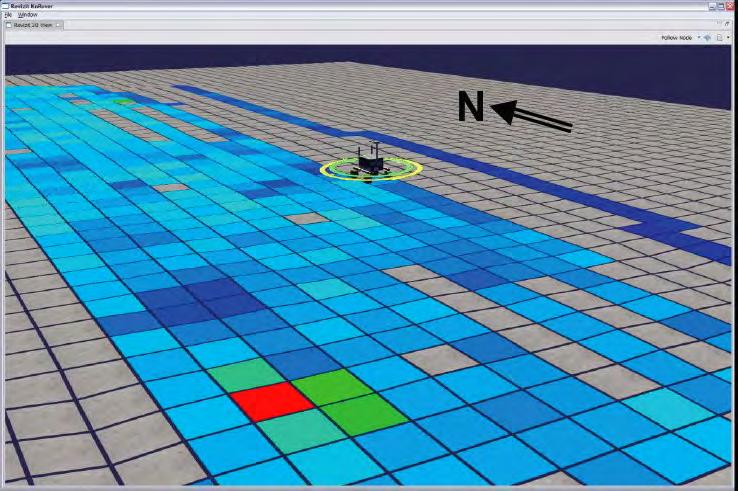
16 Visualization Tool 16

17 Phase I: Site Characterization Traverse N 17
18 Phase I: Site Characterization Traverse Epithermal Neutrons N 18

19 Phase I: Site Characterization Traverse Thermalized Neutrons N 19
20 Phase II: Interesting Locations Return to hot or cold spots Focus on characterizing extent of deposit 20

21 All Traverses Added Together 21
22 All Traverses Added Together Epithermal Neutron Map 22

23 All Traverses Added Together Thermal Neutron Map 23
24 All Traverses Added Together Beach Sand Thermal Neutron Map Gypsum Polyethylene ice 24

25 GoogleEarth View of Site Old satellite imagery Low thermal neutron return associated with darker toned materials Geochemical analysis of samples: darker has higher Fe 2 O 3. All materials have ~10 wt% water-equivalent hydrogen. 25
26 HYDRA Test Summary Test site soils more like Mars than Moon! High Fe 2 O 3 : 5-8 wt%, absorbs thermals H 2 O: ~10 wt%, clays plus moisture Detected, located shallow ice proxies But test site soil H 2 O obscured deeper deposits Better lunar analog test site needed Dry material, no hydrous minerals, lower FeO 26
 to robots")
27 Conclusion Key Points Systematic survey is one task that should be performed by robots Robotic surveying is realistic & achievable (TRL 5) Unproductive for crew to have to perform manually Intermittent control is sufficient for IVA & ground operations Mission performance can be increased by off-loading utility tasks (routine, tedious, repetitive) to robots 27

28 Intelligent Robotics Group Intelligent Systems Division NASA Ames Research Center irg.arc.nasa.gov Copyright 2009
Field Testing of K10 with HYDRA at NASA Ames Research Center
 1119 Field Testing of K10 with HYDRA at NASA Ames Research Center R. Elphic 1, L. Kobayashi 2, M. Allan 2, M. Bualat 2, M. Deans 2, T. Fong 2, S. Y. Lee 2, V. To 2, and H. Utz 2 1 Planetary Systems Branch,
NASA: BACK TO THE MOON
 NASA: BACK TO THE MOON Don Campbell Cornell University "I believe that this nation should commit itself to achieving the goal, before this decade is out, of landing a man on the moon and returning him
Lunar Poles. Status of Understanding a Potential Resource. Paul G. Lucey
 Lunar Poles Status of Understanding a Potential Resource Paul G. Lucey Hawaii Institute of Geophysics & Planetology School of Ocean and Earth Science and Technology University of Hawaii at Manoa The Most
Lunar Exploration Requirements and Data Acquisition Architectures
 Lunar Exploration Requirements and Data Acquisition Architectures J. Plescia P. Spudis B. Bussey Johns Hopkins University / Applied Physics Laboratory 2005 International Lunar Conference The Vision and
Conducting Subsurface Surveys for Water Ice using Ground Penetrating Radar and a Neutron Spectrometer on the Lunar Electric Rover Never Stop
 Conducting Subsurface Surveys for Water Ice using Ground Penetrating Radar and a Neutron Spectrometer on the Lunar Electric Rover LPI/Kring Never Stop Exploring David A. Kring Lunar and Planetary Institute
Mars Science Laboratory: Mission Perspective
 Mars Science Laboratory: Mission Perspective John Grotzinger JPL/Caltech MSL Project Scientist Science Goals MSL s primary scientific goal is to explore a landing site as a potential habitat for life,
Terramechanics Based Analysis and Motion Control of Rovers on Simulated Lunar Soil
 ICRA '07 Space Robotics Workshop 14 April, 2007 Terramechanics Based Analysis and Motion Control of Rovers on Simulated Lunar Soil Kazuya Yoshida and Keiji Nagatani Dept. Aerospace Engineering Graduate
Sun-Synchronous Robotic Exploration
 Sun-Synchronous Robotic Exploration Frequently Asked Questions What is sun-synchronous navigation? Sun-synchronous navigation is a technique that involves tracking the sun while exploring terrain. It is
History & Scope of Remote Sensing FOUNDATIONS
 History & Scope of Remote Sensing FOUNDATIONS Lecture Overview Introduction Overview of visual information Power of imagery Definition What is remote sensing? Definition standard for class History of Remote
Technologies for Transparency Dynamic Open Data Publishing with Open APIs
 International Open Government Data Conference Technologies for Transparency Dynamic Open Data Publishing with Open APIs Kendall Clark, Cofounder and Managing Principal, Clark & Parsia LLC Dan Melton, Ph.D.,
Today s Class. Results for Exam #2 11/7/2017. Today s Class: Robotic & Human Exploration of Mars
 11/7/2017 Today s Class: Robotic & Human Exploration of Mars Results for Exam #2 Homework: 1. Reading for Earth as a Planet: Section 9.4 of Cosmic Perspective. 2. Meet at Fiske on Thursday! Average Median
Mini-RF: An Imaging Radar for the Moon. Ben Bussey The Johns Hopkins University Applied Physics Laboratory
 Mini-RF: An Imaging Radar for the Moon Ben Bussey The Johns Hopkins University Applied Physics Laboratory Paul D. Spudis President s Commission on Implementation of United States Space Exploration Policy
The Moon's Dark, Icy Poles
 1 of 5 posted June 4, 2003 The Moon's Dark, Icy Poles --- Permanently shadowed regions on the Moon--where frozen water could be trapped--are more abundant and more widely distributed than originally thought.
DARPA Lunar Study: Reducing the technical risk associated with lunar resource utilization and lunar surface presence
 Space Missions DARPA Lunar Study: Reducing the technical risk associated with lunar resource utilization and lunar surface presence International Lunar Conference 2005 Toronto, Canada Paul Fulford 1, Karen
Robotic Lunar Exploration Scenario JAXA Plan
 Workshop May, 2006 Robotic Lunar Exploration Scenario JAXA Plan Tatsuaki HASHIMOTO JAXA 1 Question: What is Space Exploration? Answers: There are as many answers as the number of the people who answer
Absolute map-based localization for a planetary rover
 Absolute map-based localization for a planetary rover Bach Van Pham, Artur Maligo and Simon Lacroix LAAS/CNRS, Toulouse Work developed within the ESA founded Startiger activity Seeker Outline" On the importance
Comparison of geophysical. techniques to determine depth to. bedrock in complex weathered. environments of the Mount Crawford. region, South Australia
 Comparison of geophysical techniques to determine depth to bedrock in complex weathered environments of the Mount Crawford region, South Australia Thesis submitted in accordance with the requirements of
Robotic Follow-up for Human Exploration
 AIAA SPACE 2010 Conference & Exposition 30 August - 2 September 2010, Anaheim, California AIAA 2010-8605 Robotic Follow-up for Human Exploration Terrence Fong 1, Maria Bualat 1, Matthew C. Deans 1, Byron
1.2: Observing the Surfaces of Mars and Earth
 GEOLOGY ON MARS Unit 1 - Chapter 1-2 Comparing Rocky Planets 1.2: Observing the Surfaces of Mars and Earth Log on to Amplify Geology on Mars Chapter 1.2 In a moment, you will watch a video made by other
Using analogue missions to develop Lunar exploration strategies. Marianne Mader Carleton University, Ottawa, Canada
 Using analogue missions to develop Lunar exploration strategies Marianne Mader Carleton University, Ottawa, Canada Space fairing Nations are developing their plans for space exploration: US Vision for
Rationale of NASA Lunar Precursor Robotic Program (LPRP) for the VSE
 for the VSE") Rationale of NASA Lunar Precursor Robotic Program (LPRP) for the VSE (vs. I don t need nuthin but a map) Jeff Plescia, Ben Bussey, Paul Spudis, Tony Lavoie Applied Physics Laboratory, Johns Hopkins University
Rationale of NASA Lunar Precursor Robotic Program (LPRP) for the VSE (vs. I don t need nuthin but a map) Jeff Plescia, Ben Bussey, Paul Spudis, Tony Lavoie Applied Physics Laboratory, Johns Hopkins University
Lunar Precursor Robotics Program
 National Aeronautics and Space Administration SCIENCE & MISSION SYSTEMS Lunar Precursor Robotics Program Michael J. Wargo, Sc.D. Chief Lunar Scientist for Exploration Systems Larry Hill LRO Mission Manager
Oil and natural gas on Mars
 Oil and natural gas on Mars John F. McGowan NASA Ames Research Center Mail Stop 233-18 Moffett Field, CA 94035-1000 7/28/00 1 Outline of Talk Oil and natural gas on Earth and Mars Instrumentation Ground
Advanced Probes for Planetary Surface and Subsurface Exploration
 Workshop on Space Robotics, ICRA 2011 Advanced Probes for Planetary Surface and Subsurface Exploration Takashi Kubota (JAXA/ISAS/JSPEC) Hayato Omori, Taro Nakamura (Chuo Univ.) JAXA Space Exploration Program
Europe to the Moon. BHF 10 Feb 2005 SPC
 Europe to the Moon V162 lift-off on 27 September 2003 at 23:14:39 UTC The launch was perfect SMART-1 separated at 23:56:03 into a GTO (656 x 35,881 km): perfect injection 100 s later telemetry was received
Mars Science Laboratory - Overview Mars Express Conference
 Mars Science Laboratory - Overview Mars Express Conference February 2005 Michael Meyer MSL Program Scientist Mars Science Laboratory the AO The overall MSL science objective is to explore and quantitatively
Scientific Contributions of Lunar Robotic Precursor Missions
 Scientific Contributions of Lunar Robotic Precursor Missions Paul D. Spudis Johns Hopkins University Applied Physics Laboratory paul.spudis@jhuapl.edu www.spudislunarresources.com Presentation to LEAG
TIME DOMAIN ELECTROMAGNETICS IN MARS ANALOG ENVIRONMENTS: COMPARING TWO FIELD STUDIES. Joern A. Jernsletten 1
 AAS 06-256 TIME DOMAIN ELECTROMAGNETICS IN MARS ANALOG ENVIRONMENTS: COMPARING TWO FIELD STUDIES Joern A. Jernsletten 1 The purpose of this study is to evaluate the use of (diffusive) Time Domain Electromagnetics
Analogue Mission Simulations
 Analogue Mission Simulations Briefing Topic: Potential Locations for NEO Mission Simulations, Black Point Lava Flow, Arizona David A. Kring Analogue Mission Simulations Contents: Previous BPLF Mission
Lunar Field Exploration Science
 Lunar Field Exploration Science Harrison H. Schmitt (In Conjunction with FEAT) Workshop on Science Associated with the Lunar Exploration Architecture The Tempe Conference February 26-March 2 What Lunar
Student Briefing: Lunar Electric Rover (LER) and Crew Activities, Black Point Lava Flow David A. Kring
 and Crew Activities, Black Point Lava Flow David A. Kring") Student Briefing: Lunar Electric Rover (LER) and Crew Activities, Black Point Lava Flow David A. Kring December 2009 2009 Desert Research and Technology Studies (Desert RATS) Joe Kosmo, Mission Manager
Student Briefing: Lunar Electric Rover (LER) and Crew Activities, Black Point Lava Flow David A. Kring December 2009 2009 Desert Research and Technology Studies (Desert RATS) Joe Kosmo, Mission Manager
Ronin and Dayton Placer Ground-penetrating Radar Survey Report
 Ronin and Dayton Placer Ground-penetrating Radar Survey Report Tenures: 837095, 837097, 889865, 890187 Mining Division: Greenwood NTS Location: 082E/03 Geographic Center Coordinates: UTM Zone 11, E 345340,
Resource Prospector Drill
 Resource Prospector Drill Kris Zacny, Honeybee Robotics zacny@honeybeerobotics.com Gale Paulsen, Honeybee Robotics Jackie Quinn, NASA KSC Jim Smith, NASA KSC Julie Kleinhenz, NASA GRC LEAG, 20-22 October
THE USE OF GEOMATICS IN CULTURAL HERITAGE AND ARCHAEOLOGY FOR VARIOUS PURPOSES
 THE USE OF GEOMATICS IN CULTURAL HERITAGE AND ARCHAEOLOGY FOR VARIOUS PURPOSES FEBRUARY 2013 AL BEIDA GEOPLAN CONTENT Company Profile Concept Objectives and Strategies Data Production Methods Data Samples
Robotic Planetary Exploration by Sun-Synchronous Navigation
 Robotic Planetary Exploration by Sun-Synchronous Navigation David Wettergreen, Benjamin Shamah, Paul Tompkins, William Whittaker The Robotics Institute Carnegie Mellon University Pittsburgh, PA 15213-3890
The Latest from Mars: Recent Results and the Next Decade of Exploration
 The Latest from Mars: Recent Results and the Next Decade of Exploration Brian M. Hynek Laboratory for Atmospheric and Space Physics & Department of Geological Sciences, University of Colorado Mars ½ diameter
Test Bank Chapter 2: Representations of Earth
 Multiple Choice Test Bank Chapter 2: Representations of Earth 1. A rhumb line on a Mercator projection is a line of. a. true size b. true shape c. true compass bearing d. true location 2. Maximum longitude
Italian Lunar Science Studies and Possible Missions a.k.a. The Moon: an Italian Approach. Angioletta Coradini Istituto Nazionale di Astrofisica
 Italian Lunar Science Studies and Possible Missions a.k.a. The Moon: an Italian Approach Angioletta Coradini Istituto Nazionale di Astrofisica Goals of the Study The primary goal of the present study is
NUCLEAR AND RELATED TECHNIQUES FOR PLANETOLOGY
 NUCLEAR AND RELATED TECHNIQUES FOR PLANETOLOGY V.Shvetsov, FLNP, JINR Round Table Italy-Russia @ Dubna on PLANETARY SCIENCE The scientific study of planets (including Earth), moons, and planetary systems,
Exercise 1: Earth s Moon
 PHYS1014 Physical Science Summer 2013 Professor Kenny L. Tapp Exercise 1: Earth s Moon Complete and submit this packet, securely stapled, at the beginning of Exam 1. PART I --- Online Video Lecture from
EXTREMELY FAST IP USED TO DELINEATE BURIED LANDFILLS. Norman R. Carlson, Cris Mauldin Mayerle, and Kenneth L. Zonge
 EXTREMELY FAST IP USED TO DELINEATE BURIED LANDFILLS Norman R. Carlson, Cris Mauldin Mayerle, and Kenneth L. Zonge Zonge Engineering and Research Organization, Inc. 3322 East Fort Lowell Road Tucson, Arizona,
The Moon: Stepping Stone to the Planets
 The Moon: Stepping Stone to the Planets William A. Ambrose Houston Geological Society May 10, 2017 Schmitt (2004) Why Return to the Moon? Earth s closest neighbor -Three-day trip -Technology already exists
HERA MISSION & CM16 lessons learned
 HERA MISSION HERA MISSION & CM16 lessons learned (CM16) Schedule criticality for 2020 launch Prepare Asteroid mission with launch opportunities in 2023 (with back-up in 2024 and 2025) (CM16) Payload selection
Thermal, Thermophysical, and Compositional Properties of the Moon Revealed by the Diviner Lunar Radiometer
 Thermal, Thermophysical, and Compositional Properties of the Moon Revealed by the Diviner Lunar Radiometer Benjamin T. Greenhagen Jet Propulsion Laboratory David A. Paige and the Diviner Science Team LEAG
GIS and Remote Sensing
 Spring School Land use and the vulnerability of socio-ecosystems to climate change: remote sensing and modelling techniques GIS and Remote Sensing Katerina Tzavella Project Researcher PhD candidate Technology
SOIL MECHANICS OF LUNAR REGOLITH SIMULANTS FOR PROBE LANDING AND ROVER LOCOMOTION
 SOIL MECHANICS OF LUNAR REGOLITH SIMULANTS FOR PROBE LANDING AND ROVER LOCOMOTION Kazuya Yoshida *1, Keiji Nagatani *1, Genya Ishigami *1, Shigehito Shimizu *1 Kozo Sekimoto *2, Akira Miyahara *3, Takaaki
Asteroid Sample Return and the Path to Exploration of Near-Earth Space* By Dante S. Lauretta 1
 Asteroid Sample Return and the Path to Exploration of Near-Earth Space* By Dante S. Lauretta 1 Search and Discovery Article #70044 (2008) Posted August 25, 2008 *Adapted from oral presentation at AAPG
SCIENCE WITH DIRECTED AERIAL DR. ALEXEY PANKINE GLOBAL AEROSPACE CORPORATION SAILING THE PLANETS
 : SCIENCE WITH DIRECTED AERIAL ROBOT EXPLORERS (DARE) DR. ALEXEY PANKINE GLOBAL AEROSPACE CORPORATION 1 NEW ARCHITECTURE FOR PLANETARY EXPLORATION KEY ELEMENTS: Long-Duration Planetary Balloon Platforms
The SPE Foundation through member donations and a contribution from Offshore Europe
 Primary funding is provided by The SPE Foundation through member donations and a contribution from Offshore Europe The Society is grateful to those companies that allow their professionals to serve as
Geomorphologic Mapping by Airborne Laser Scanning in Southern Victoria Land
 Geomorphologic Mapping by Airborne Laser Scanning in Southern Victoria Land Bea Csatho, Terry Wilson, Tony Schenk, Garry McKenzie, Byrd Polar Research Center, The Ohio State University, Columbus, OH William
Moon Express Advancing Commerce and Science
 Moon Express Advancing Commerce and Science Paul D. Spudis Bob Richards Jack Burns Moon Express Inc. October, 2013 1 Moon Express Landers Possible Missions Surface Network 2 Mission Types: Small lander
Operation status for the asteroid explorer, Hayabusa2
 Operation status for the asteroid explorer, Hayabusa2 October 23, 2018 JAXA Hayabusa2 Project Regarding Hayabusa2: Contents Today Report on TD1-R1-A TD1-R3 operation plan TD1-R1-A Touchdown 1 rehearsal
LRO-LOLA: Measurements of Lunar Altimetry and Surface Conditions
 LRO-LOLA: Measurements of Lunar Altimetry and Surface Conditions David E. Smith, MIT Maria T. Zuber, MIT Gregory A. Neumann, GSFC Erwan Mazarico, GSFC and the LOLA Science Team Lunar-Glob Mission International
The Arctic - A New Frontier The geological, environmental and engineering challenges for submarine telecommunication cables
 The Arctic - A New Frontier The geological, environmental and engineering challenges for submarine telecommunication cables Ryan Wopschall 5 September 2013 Oceanology International China, Shanghai Fugro
H. Minamino, H. Hoshino, M. Kato, S. Sasaki and Y. Takizawa Japan Aerospace Exploration Agency (JAXA) SELENE Project Team
 SELENE Project Team") SELENE Project Status H. Minamino, H. Hoshino, M. Kato, S. Sasaki and Y. Takizawa Japan Aerospace Exploration Agency (JAXA) SELENE Project Team Contents of the presentation : SELENE Project Status SELENE
SELENE Project Status H. Minamino, H. Hoshino, M. Kato, S. Sasaki and Y. Takizawa Japan Aerospace Exploration Agency (JAXA) SELENE Project Team Contents of the presentation : SELENE Project Status SELENE
Mapping the Moon Lesson 7: Making a Model
 PREVISIT ACTIVITY Space Explorers Trading Cards or Space Exploration Timeline Mapping the Moon Lesson 7: Making a Model 5E MODEL Elaborate GRADE LEVEL Middle School NSES STANDARDS (National Science Education
HEOMD Overview March 16, 2015
 National Aeronautics and Space Administration HEOMD Overview March 16, 2015 Ben Bussey Chief Exploration Scientist HEOMD, NASA HQ National Aeronautics and Space Administration NASA Strategic Plan Objective
The ExoMars Programme
 E X O M A R S The ExoMars Programme PHOOTPRINT Scientific context E X O M A R S - A primitive Mars and an early evolution similar to that early of evolution the Earth similar to that A primitive Mars likely
Formation Flying and Rendezvous and Docking Simulator for Exploration Missions (FAMOS-V2)
") Formation Flying and Rendezvous and Docking Simulator for Exploration Missions (FAMOS-V2) Galder Bengoa, F. Alonso, D. García, M. Graziano (GMV S.A.) Dr. Guillermo Ortega (ESA/ESTEC) 2nd ESA Workshop on
Formation Flying and Rendezvous and Docking Simulator for Exploration Missions (FAMOS-V2) Galder Bengoa, F. Alonso, D. García, M. Graziano (GMV S.A.) Dr. Guillermo Ortega (ESA/ESTEC) 2nd ESA Workshop on
Exploring the Moon & Asteroids: A Synergistic Approach
 Exploring the Moon & Asteroids: A Synergistic Approach Clive R. Neal Dept. Civil Eng. & Geological Sci. University of Notre Dame Notre Dame, IN 46556, USA neal.1@nd.edu Perspective Perspective SCIENCE
A Proposed Approach for Characterizing Large Military Ranges
 A Proposed Approach for Characterizing Large Military Ranges Jay Clausen Physical Research Scientist Hanover, NH July 25, 2013 US Army Corps of Engineers Large Ranges Characterization Issues Lack of a
Applications of GIS in assessing Coastal Change Rachel Hehre November 30, 2004 NRS 509 OVERVIEW
 Applications of GIS in assessing Coastal Change Rachel Hehre November 30, 2004 NRS 509 OVERVIEW ITRODUCTION Due to the dynamic nature of coastal systems, representing coastal change with precision and
Presented by: Sydney Brewer, Erin Manuel, Julie Ponton, Shannon Smith, and Caroline Stasiowski Seton Keough High School, Baltimore, Maryland
 Presented by: Sydney Brewer, Erin Manuel, Julie Ponton, Shannon Smith, and Caroline Stasiowski Seton Keough High School, Baltimore, Maryland Questions: What are the differences between a complex and simple
Where we are now. The Moon Chapters 8.2, 9. Topography. Outline
 Where we are now Introduction Little things - comets, asteroids, KBOs Slightly larger things - Moon Larger still - Terrestrial planets Really large - Jovian planets Jovian moons + Pluto Extrasolar Planets
First Experiment in Sun-Synchronous Exploration
 First Experiment in Sun-Synchronous Exploration David Wettergreen, Bernardine Dias, Benjamin Shamah, James Teza, Paul Tompkins, Chris Urmson, Michael Wagner, William Whittaker The Robotics Institute Carnegie
Remote sensing of the. Earth & Planets
 Remote sensing of the 1 Earth & Planets Morning Exercises! T/F Heat is only produced at thermal wavelengths. Morning Exercises! T/F Heat is only produced at thermal wavelengths. Does all ma@er emit radiaaon/light/energy/photons?
Prospector-1: A Low-Cost Commercial Asteroid Mission Grant Bonin SmallSat 2016
 Prospector-1: A Low-Cost Commercial Asteroid Mission Grant Bonin SmallSat 2016 About DSI A space technology and resources company Vision to enable the human space development by harvesting asteroid materials
First Experiment in Sun-Synchronous Exploration
 First Experiment in Sun-Synchronous Exploration David Wettergreen, Bernardine Dias, Benjamin Shamah, James Teza, Paul Tompkins, Chris Urmson, Michael Wagner, William Whittaker The Robotics Institute Carnegie
Dive In What is an advantage of sending unmanned crafts to space?
 Dive In What is an advantage of sending unmanned crafts to space? Manned and Robotic Spacecraft For Each Space Vehicle, complete the worksheet including: 1. If the spacecraft is manned or unmanned. 2.
ERS-ENVISAT CROSS-INTERFEROMETRY SIGNATURES OVER DESERTS. Urs Wegmüller, Maurizio Santoro and Christian Mätzler
 ERS-ENVISAT CROSS-INTERFEROMETRY SIGNATURES OVER DESERTS Urs Wegmüller, Maurizio Santoro and Christian Mätzler Gamma Remote Sensing AG, Worbstrasse 225, CH-3073 Gümligen, Switzerland, http://www.gamma-rs.ch,
Quantifying Coastal Evolution using Remote Sensing Approaches
 Quantifying Coastal Evolution using Remote Sensing Approaches Sojan Mathew, Linh Truong Hong, Xavier Pellicer*, Colman Gallagher University College Dublin Geological Survey of Ireland* INFOMAR SEMINAR,
ROVERQUEST: Greetings from Gusev
 Mars Exploration Rover: Mars for Educators: Roverquest http://marsrovers.jpl.nasa.gov/classroom/roverquest/lesson02pr... ROVERQUEST: Greetings from Gusev EDUCATIONAL OBJECTIVE: This activity will place
Unit 1 Habitable Worlds
 Unit 1 Habitable Worlds Learning objectives: 3 things needed for life 2 Types of organisms (producers and consumers) Most important elements for life Habitable World Video Notes Essential question: What
MSL Landing Site Analysis for Planetary Protection
 MSL Landing Site Analysis for Planetary Protection Ashwin R. Vasavada MSL Deputy Project Scientist Jet Propulsion Laboratory, California Institute of Technology NASA Planetary Protection Subcommittee May
Expanding Science with SmallSats/CubeSats
 National Aeronautics and Space Administration Expanding Science with SmallSats/CubeSats Outer Planets Analysis Group John D. Baker 2/2/2016 2016, Government Sponsorship Acknowledged National Aeronautics
Drilling: How do we access subsurface on Mars
 Drilling: How do we access subsurface on Mars Dr. Kris Zacny Keck Institute for Space Studies (KISS) MarsX January 12, 2018 Director of Exploration Technology Group Honeybee Robotics zacny@honeybeerobotics.com
Moon and Mercury 3/8/07
 The Reading Assignment Chapter 12 Announcements 4 th homework due March 20 (first class after spring break) Reminder about term paper due April 17. Next study-group session is Monday, March 19, from 10:30AM-12:00Noon
Exploring our Solar System and Beyond
 Exploring our Solar System and Beyond AFCEA Larry James, Deputy Director February 18, 2016 Jason 3 Launch January 17, 2016 JPL Science and Exploration Thrusts 1 2 3 4 Journey to Mars Formation of and life
The CNES contribution to in-situ exploration : robotic implications
 The CNES contribution to in-situ exploration : robotic implications Pierre W. BOUSQUET Head of Planetology and Microgravity project office With the contribution of Alain GABORIAUD, Philippe GAUDON, Philippe
Present Status of the Payload Development for Chang e-1
 September.19,2005 Huixian Sun 1, Ji Wu 1, Baochang Zhao 2, Rong Shu 3, Nan Zhang 4, Huanyu Wang 5, Qingying Ren 1, Xiaohui Zhang1, Xiaomin Chen1 1 Center for Space Science and Applied Research, 2 Xi'an
page - Lab 13 - Introduction to the Geology of the Terrestrial Planets
 page - Lab 13 - Introduction to the Geology of the Terrestrial Planets Introduction There are two main families of planets in our solar system: the inner Terrestrial planets (Earth, Mercury, Venus, and
Ronin Placer Ground-penetrating Radar Survey Report
 Ronin Placer Ground-penetrating Radar Survey Report Tenures: 837095, 837097 Mining Division: Greenwood NTS Location: 082E/03 Geographic Center Coordinates: UTM Zone 11, E 345340, N 5438730 Claims Owner:
ICE ENVIRONMENTAL DATA COLLECTION FOR THE NORTH CASPIAN SEA
 Ice in the Environment: Proceedings of the 16th IAHR International Symposium on Ice Dunedin, New Zealand, 2nd 6th December 2002 International Association of Hydraulic Engineering and Research ICE ENVIRONMENTAL
An Earth Auger as Excavator for Planetary Underground Explorer Robot. Using Peristaltic Crawling
 An Earth Auger as Excavator for Planetary Underground Explorer Robot Using Peristaltic Crawling H. Omori *, T. Murakami, H. Nagai, T. Nakamura **, and T. Kubota *** * Department of Precision Mechanics,
S.H.E.R.P.A. Mk 404 RED ROVER OPERATIONS MANUAL
 VRX 10-1 THE DEPARTMENT OF SPACE DEPARTMENTS S.H.E.R.P.A. Mk 404 RED ROVER OPERATIONS MANUAL DO NOT FOLD TABLE OF CONTENTS TABLE OF CONTENTS 1 GETTING STARTED 2 WHY RED ROVER? 3 SETTINGS & PREFERENCES
Mapping Earth. How are Earth s surface features measured and modeled?
 Name Mapping Earth How are Earth s surface features measured and modeled? Before You Read Before you read the chapter, think about what you know about maps Record your thoughts in the first column Pair
Multi-Sensor Fusion for Localization of a Mobile Robot in Outdoor Environments
 Multi-Sensor Fusion for Localization of a Mobile Robot in Outdoor Environments Thomas Emter, Arda Saltoğlu and Janko Petereit Introduction AMROS Mobile platform equipped with multiple sensors for navigation
What is scan? Answer key. Space Communications and Navigation Program. Entering the Decade of Light.
 National Aeronautics and Space Administration SCaN Fun Pad www.nasa.gov NP-2018-02-047-GRC 30 1 What is scan? Answer key Page 22 Find the Mars Rover: Space Communications and Navigation Program The Space
PROSPECT: ESA s Package for Resource Observation and In-Situ Prospecting for Exploration, Commercial Exploitation and Transportation
 PROSPECT: ESA s Package for Resource Observation and In-Situ Prospecting for Exploration, Commercial Exploitation and Transportation E. Sefton-Nash, J. Carpenter and the PROSPECT Team LRO/LROC/ASU Lunar
InSight Spacecraft Launch for Mission to Interior of Mars
 InSight Spacecraft Launch for Mission to Interior of Mars InSight is a robotic scientific explorer to investigate the deep interior of Mars set to launch May 5, 2018. It is scheduled to land on Mars November
OPAG Aug. 24, Europa Mission Science Overview
 OPAG Aug. 24, 2015 Europa Mission Science Overview Bob Pappalardo Europa Project Scientist Jet Propulsion Laboratory, California Institute of Technology Europa Program Scientist, NASA Headquarters Goal:
Examining the Terrestrial Planets (Chapter 20)
") GEOLOGY 306 Laboratory Instructor: TERRY J. BOROUGHS NAME: Examining the Terrestrial Planets (Chapter 20) For this assignment you will require: a calculator, colored pencils, a metric ruler, and your geology
GEOLOGY 306 Laboratory Instructor: TERRY J. BOROUGHS NAME: Examining the Terrestrial Planets (Chapter 20) For this assignment you will require: a calculator, colored pencils, a metric ruler, and your geology
3-D ground-penetrating radar surveys on a frozen river lagoon
 3-D ground-penetrating radar surveys on a frozen river lagoon Monica Moldoveanu and Robert R. tewart ABTRACT Ground-penetrating radar (GPR) surveys were acquired at Bowness Park, Calgary to characterize
Where do they come from?
 Exploring Meteorite Mysteries Lesson 7 Crater Hunters Objectives Students will: observe impact craters on Earth and other solar system bodies. discuss geologic forces that have removed most of the evidence
Activity 7 At a Glance
 At a Glance Where Would You Search for Water on Mars? Purpose To help students develop an ongoing connection to the Mars missions Overview Students generate questions based on their module experiences
Payloads. Andrew J. Ball Short Course on Small Satellites, IPPW-15 Boulder, CO, 9 June 2018
 Payloads Andrew J. Ball Short Course on Small Satellites, IPPW-15 Boulder, CO, 9 June 2018 1 Outline Biography Natural Sciences (mostly Physics ) Bachelor degree (U. of Cambridge) M.Sc. in Spacecraft Technology
Ramani Geosystems. Putting Africa On The Map. Authorized Resellers
 Ramani Geosystems Putting Africa On The Map Authorized Resellers Ramani Profile Started in 1999 Aerial, Land Surveying & Mapping Solutions + 10 Countries in the region + 80 Staff working in projects Asset
DESING AND ANALYSIS OF SATELLITE SOLAR PANEL GRADUATION PROJECT. Büşra ÇATALBAŞ. Department of Astronautical Engineering
 ISTANBUL TECHNICAL UNIVERSITY FACULTY OF AERONAUTICS AND ASTRONAUTICS DESING AND ANALYSIS OF SATELLITE SOLAR PANEL GRADUATION PROJECT Büşra ÇATALBAŞ Department of Astronautical Engineering Thesis Advisor:
Status of Mars Science Laboratory Presentation to Mars Panel Planetary Science Decadal Survey. September 9-11, 2009 Fuk Li Mars Exploration Program
 Status of Mars Science Laboratory Presentation to Mars Panel Planetary Science Decadal Survey September 9-11, 2009 Fuk Li Mars Exploration Program MSL Status: Overview Science capability of MSL remains
LOZAR RADAR INTRODUCTORY PRESENTATION COAL SURVEYING
 LOZAR RADAR INTRODUCTORY PRESENTATION COAL SURVEYING WWW.LOZARRADAR.COM ABOUT LOZAR RADAR Lozar Radar is a ground-scanning device, which verifies and investigates the presence of mineral resources and