Technologies for Transparency Dynamic Open Data Publishing with Open APIs
|
|
|
- Amanda Brown
- 5 years ago
- Views:
Transcription


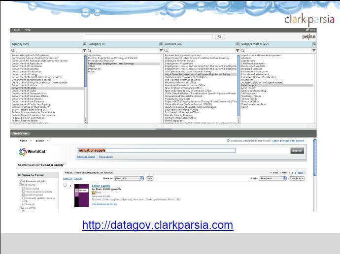
1 International Open Government Data Conference Technologies for Transparency Dynamic Open Data Publishing with Open APIs Kendall Clark, Cofounder and Managing Principal, Clark & Parsia LLC Dan Melton, Ph.D., MPA, Technical Director, Code for America Derek Willis, Newsroom Developer, The New York Times George Thomas, Enterprise Architect, U.S. HHS (Moderator) 11
2 The Lunar Mapping and Modeling Project The Moon within Reach
3 Project Background & Overview The Lunar Mapping and Modeling Project (LMMP) was initiated in 2007 to help in making the anticipated results of the Lunar Reconnaissance Orbiter (LRO) spacecraft useful and accessible to future missions, to the public and to other future applications The LMMP is managing and developing a suite of lunar mapping and modeling tools and products New instruments are giving us amazingly dense data sets The most highly detailed view of our Moon we have ever seen New discoveries altering the way with think about the Moon and our solar system International Open Government Data Conference, Nov 15-17, Washington DC 13
 gravity")
 Clementine (USA) Lunar")
")

4 LRO (USA) Multiple Global Data Sources Kaguya (Japan) gravity model data) Chandrayaan-1 (India) Clementine (USA) Lunar Prospector (USA) Apollo (USA; metric & panoramic cameras) International Open Government Data Conference, Nov 15-17, Washington DC 14
5 Multiple Global Customers The information provided through LMMP will assist them in: planning tasks in the areas of landing site evaluation and selection design and placement of landers and other stationary assets design of rovers and other mobile assets developing terrain-relative navigation (TRN) capabilities assessment and planning of science traverses The science communities The commercial community (e.g. Google Lunar X-prize, gamers) Public Engagement & Education communities! Participatory Exploration: It s fundamental to NASA s core mission Portal will be available to provide interactive capabilities Downloads of data encouraged; APIs to be published International Open Government Data Conference, Nov 15-17, Washington DC 15
 Combined Sources Create Digital")
 and Apollo 15")

6 Local DEMs from LRO Camera (LROC) Narrow Angle Camera (NAC) covering 50 mission regions of interest (ROI) Combined Sources Create Digital Elevation Models Preliminary USGS Aristarchus Plateau (DEM 1) from JSC/ASU Apollo Pan Cam Scans Malapert Mountain (left) and Apollo 15 (right) ROIs showing in red the NAC images acquired through the 1st month of mapping orbit International Open Government Data Conference, Nov 15-17, Washington DC 16


7 Created Products - Hazard Maps Craters Boulders Slopes Surface Roughness International Open Government Data Conference, Nov 15-17, Washington DC 17

8 Search, Locate & Download Auxiliary Files International Open Government Data Conference, Nov 15-17, Washington DC 18


9 Plan Your Trip To The Moon Integrated Lunar Information Architecture Lunar Surface Traverse Tool (oblique view) Goldstone Radar of South Pole (oblique view) You can pick from multiple data sources, depending on what you want to do International Open Government Data Conference, Nov 15-17, Washington DC 19

10 Displays Multiple Data Sources International Open Government Data Conference, Nov 15-17, Washington DC 20


 LMMP ILIADS Desktop")

 LMMP Portal UI Data")

 LMMP Portal Product /")
 PDS Archives LMMP Product")

 Informal")
")

 Informal Chandrayaan Mission")
11 The Portal Will Serve Up Mashes, APIs, Files GoogleEarth Desktop Visualization ArcGIS Desktop Analysis & Visualization STK Desktop Analysis & Visualization OTHER Analysis & Visualization Apps LMMP Lunar Mapper Web Visualization & Light Analysis (CRREL) LMMP ILIADS Desktop Visualization & Rich Analysis (GSFC) LMMP XGIS / OnMoon Product Tiling, WMS, WCS (JPL) LMMP Portal Product Catalog (JPL) LMMP Portal UI Data Distribution, Search, Browse, View, User Authentication, Download, APIs, etc. (JPL) LMMP Portal User Workspace & Storage (JPL) LMMP Portal Product / Metadata Staging, Ingestion & Storage (JPL) PDS Archives LMMP Product Development Image Mosaics, DEM Products, Hazards, Lighting, Resources, etc. (ARC, ASU & UA, JPL, USGS) Informal LRO Mission / Instrument Data (DLRE, LAMP, LEND, LROC, LOLA, Mini RF) Other Mission / Instrument Data (Apollo MC & PanCam, Clementine, Kaguya, Lunar Prospector, Lunar Orbiter) Informal Chandrayaan Mission / Instrument Data (M 3, Mini SAR) International Open Government Data Conference, Nov 15-17, Washington DC 21
12 LMMP Milestones November 2010 Version 1 audit Early 2011 Version 1 release International Open Government Data Conference, Nov 15-17, Washington DC 22
13 23
14 24
15 25
16 26
17 27
18 28
19 29
20 30
21 31
Lunar Precursor Robotics Program
 National Aeronautics and Space Administration SCIENCE & MISSION SYSTEMS Lunar Precursor Robotics Program Michael J. Wargo, Sc.D. Chief Lunar Scientist for Exploration Systems Larry Hill LRO Mission Manager
Trent Hare, Lisa Gaddis, Sue LaVoie, Chris Isbell, Moses Milazzo, Sam Lawrence
 Trent Hare, Lisa Gaddis, Sue LaVoie, Chris Isbell, Moses Milazzo, Sam Lawrence PDS Cartography and Imaging Sciences Node The Imaging Node (IMG, PDS-IMG or just Imaging ) http://img.pds.nasa.gov/ Curator
ISRO Science Data Archive: Chandrayaan-1
 Chandrayaan-1 1 Payloads ISRO Science Data Archive: Chandrayaan-1 (and sample imagery) B Gopala Krishna Group Head, SPDCG/SIPA Space Applications Centre (ISRO) Ahmedabad,, INDIA bgk@sac.isro.gov.in Indian
NASA: BACK TO THE MOON
 NASA: BACK TO THE MOON Don Campbell Cornell University "I believe that this nation should commit itself to achieving the goal, before this decade is out, of landing a man on the moon and returning him
NASA Lunar Science Activities. Lunar Science and Exploration
 NASA Lunar Science Activities Lunar Science and Exploration James L. Green Director, Planetary Sciences Division Science Directorate Mission Directorate NASA In NASA s James Science L. Green Mission Presented
Scientific Contributions of Lunar Robotic Precursor Missions
 Scientific Contributions of Lunar Robotic Precursor Missions Paul D. Spudis Johns Hopkins University Applied Physics Laboratory paul.spudis@jhuapl.edu www.spudislunarresources.com Presentation to LEAG
LRO-LOLA: Measurements of Lunar Altimetry and Surface Conditions
 LRO-LOLA: Measurements of Lunar Altimetry and Surface Conditions David E. Smith, MIT Maria T. Zuber, MIT Gregory A. Neumann, GSFC Erwan Mazarico, GSFC and the LOLA Science Team Lunar-Glob Mission International
MAPSIT and a Roadmap for Lunar and Planetary Spatial Data Infrastructure
 MAPSIT and a Roadmap for Lunar and Planetary Spatial Data Infrastructure B. Archinal for the MAPSIT Steering Committee barchinal@usgs.gov LEAG Columbia, MD 2017 October 10 Outline Who are we again? What
Mapping the Moon Lesson 7: Making a Model
 PREVISIT ACTIVITY Space Explorers Trading Cards or Space Exploration Timeline Mapping the Moon Lesson 7: Making a Model 5E MODEL Elaborate GRADE LEVEL Middle School NSES STANDARDS (National Science Education
These modules are covered with a brief information and practical in ArcGIS Software and open source software also like QGIS, ILWIS.
 Online GIS Training and training modules covered are: 1. ArcGIS, Analysis, Fundamentals and Implementation 2. ArcGIS Web Data Sharing 3. ArcGIS for Desktop 4. ArcGIS for Server These modules are covered
Lunar Resources for Educators and Families
 Lunar Resources for Educators and Families Lunar Reconnaissance Orbiter Camera Program School of Earth and Space Exploration Arizona State University Children s Books (alphabetically by year) Burleigh,
Mini-RF: An Imaging Radar for the Moon. Ben Bussey The Johns Hopkins University Applied Physics Laboratory
 Mini-RF: An Imaging Radar for the Moon Ben Bussey The Johns Hopkins University Applied Physics Laboratory Paul D. Spudis President s Commission on Implementation of United States Space Exploration Policy
Analysis and application of 1-way laser ranging data to LRO
 www.dlr.de Chart 1 WLRS ranging to LRO Analysis and application of 1-way laser ranging data to LRO S. Bauer (1), J. Oberst (1,2), H. Hussmann (1), P. Gläser (2), U. Schreiber (3), D. Mao (4), G. Neumann
NEXT STEPS ON THE MOON REPORT OF THE SPECIFIC ACTION TEAM
 NEXT STEPS ON THE MOON REPORT OF THE SPECIFIC ACTION TEAM Specific Action Team Charter SAT commissioned by Science Mission Directorate, Planetary Science Division Assess lunar missions needed to address
Thermal, Thermophysical, and Compositional Properties of the Moon Revealed by the Diviner Lunar Radiometer
 Thermal, Thermophysical, and Compositional Properties of the Moon Revealed by the Diviner Lunar Radiometer Benjamin T. Greenhagen Jet Propulsion Laboratory David A. Paige and the Diviner Science Team LEAG
REVISED COORDINATES FOR APOLLO HARDWARE
 REVISED COORDINATES FOR APOLLO HARDWARE R. V. Wagner *, E. J. Speyerer, K. N. Burns, J. Danton, M.S. Robinson Lunar Reconnaissance Orbiter Camera, School of Earth and Space Exploration, Arizona State University,
Malapert Mountain: A Recommended Site for a South Polar Outpost
 For presentation at the Rutgers Symposium on Lunar Settlements, June 4-8, 2007 Malapert Mountain: A Recommended Site for a South Polar Outpost Paul. D. Lowman Jr. Goddard Space Flight Center, Code 698
Accessing the Lunar Poles for Human Exploration Missions
 B. KENT JOOSTEN NASA Lyndon B. Johnson Space Center Houston, Texas The National Vision for Space Exploration calls for an American return to the Moon in preparation for the human exploration of Mars and
Moon 101. Bellaire High School Team: Rachel Fisher, Clint Wu, Omkar Joshi
 Moon 101 Bellaire High School Team: Rachel Fisher, Clint Wu, Omkar Joshi Part I Formation of the Moon Planetary Formation In the solar nebula, dust particles coalesced to form smaller planetesimals and
Planetary Science Big Data
 Planetary Science Big Data Michael H. New, Ph.D. Planetary Data System Program Scientist 16 Feb 2016 NASA Ad Hoc Big Data Task Force 1 PSD Data Policies All science data returned from NASA missions are
GeoSUR SRTM 30-m / TPS
 GeoSUR SRTM 30-m / TPS Wm Matthew Cushing (USGS) 16 May 2013 U.S. Department of the Interior U.S. Geological Survey SRTM Mission Shuttle Radar Topography Mission (SRTM) Space Shuttle Endeavour during the
Space Studies Institute:
 Space Studies Institute: Space Manufacturing 14: Critical Technologies for Space Settlement The ILO as Property Rights Agent 29-31 October 2010 Silicon Valley, California, USA International Lunar Observatory
Lunar Satellite Attitude Determination System
 Lunar Satellite Attitude Determination System SENIOR DESIGN PROPOSAL PRESENTATION TEAM EPOCH KUPOLUYI, TOLULOPE (LEAD DEVELOPER) SONOIKI, OLUWAYEMISI (LEAD RESEARCHER) WARREN, DANAH (PROJECT MANAGER) NOVEMBER
Robotic Site Survey for ISRU
 NASA Ames Research Center Maria Bualat Intelligent Robotics Group Maria.Bualat@nasa.gov Outline Site Survey Overview GPR Survey Hydrogen Prospecting 2 Human-Robot Site Survey Project Systematic survey
Lunar Exploration Requirements and Data Acquisition Architectures
 Lunar Exploration Requirements and Data Acquisition Architectures J. Plescia P. Spudis B. Bussey Johns Hopkins University / Applied Physics Laboratory 2005 International Lunar Conference The Vision and
Signature: Name: Banner ID#:
 1 GEOLOGICAL SCIENCES 0050 I am aware of the Brown University Honor Code [see the Student Handbook, which can be accessed through the Geo0050 web site], understand that this exercise falls under that code,
Asteroid Sample Return and the Path to Exploration of Near-Earth Space* By Dante S. Lauretta 1
 Asteroid Sample Return and the Path to Exploration of Near-Earth Space* By Dante S. Lauretta 1 Search and Discovery Article #70044 (2008) Posted August 25, 2008 *Adapted from oral presentation at AAPG
LRO Plans for International Education & Public Outreach
 LRO Plans for International Education & Public Outreach Lunar Observational Technologies Across Ages & Cultures Cherilynn Morrow, SETI Institute Gordon Chin, NASA Goddard Spaceflight Center 9 th ILEWG
EXERCISE 2 (16 POINTS): LUNAR EVOLUTION & APOLLO EXPLORATION
: LUNAR EVOLUTION & APOLLO EXPLORATION") 1 GEOLOGICAL SCIENCES 0050 I am aware of the Brown University Honor Code [see the Student Handbook, which can be accessed through the Geo0050 web site], understand that this exercise falls under that code,
1 GEOLOGICAL SCIENCES 0050 I am aware of the Brown University Honor Code [see the Student Handbook, which can be accessed through the Geo0050 web site], understand that this exercise falls under that code,
James Carpenter, Lunar Lander Office, Directorate of Human Spaceflight and Operations
 The European Lunar Lander James Carpenter, Lunar Lander Office, Directorate of Human Spaceflight and Operations 1 International Context Apollo/Luna Era 1990-2006 2007-2012 2013-2020 Next Decade HITEN CLEMENTINE
LEAG Illumination Modeling at the Lunar Poles and its Benefits to Exploration and Science Investigations
 LEAG 2015 2015.10.21 Illumination Modeling at the Lunar Poles and its Benefits to Exploration and Science Investigations Erwan Mazarico and J.B. Nicholas NASA GSFC Erwan Mazarico - LEAG - October 21, 2015
Data Aggregation with InfraWorks and ArcGIS for Visualization, Analysis, and Planning
 Data Aggregation with InfraWorks and ArcGIS for Visualization, Analysis, and Planning Stephen Brockwell President, Brockwell IT Consulting, Inc. Join the conversation #AU2017 KEYWORD Class Summary Silos
We will apply two of these principles to features on the lunar surface in the following activities.
 STUDENT ACTIVITY 4 Studying the Geologic Past Scientists who study the processes that shape the surface of Earth are called geologists. They have scientific rules, which help them figure out the history
Addressing Strategic Planning for Planetary Spatial Data Infrastructure
 Addressing Strategic Planning for Planetary Spatial Data Infrastructure Samuel J. Lawrence Justin Hagerty Lisa Gaddis Brent Archinal Jani Radebaugh Shane Byrne Sarah Sutton Daniella DellaGiustina Brad
Conducting Subsurface Surveys for Water Ice using Ground Penetrating Radar and a Neutron Spectrometer on the Lunar Electric Rover Never Stop
 Conducting Subsurface Surveys for Water Ice using Ground Penetrating Radar and a Neutron Spectrometer on the Lunar Electric Rover LPI/Kring Never Stop Exploring David A. Kring Lunar and Planetary Institute
Plans for an International Lunar Network
 Science Mission Directorate Plans for an International Lunar Network Tom Morgan May 2008 ROBOTIC LUNAR EXPLORATION Starting no later than 2008, initiate a series of robotic missions to the Moon to prepare
Lunar Reconnaissance Orbiter Mission Objectives
 Lunar Reconnaissance Orbiter (LRO) Overview The Instrument Suite and Mission Status Gordon Chin LRO Project Scientist NASA Goddard Space Flight Center 9th ILEWG International Conference on Exploration
Analogue Mission Simulations
 Analogue Mission Simulations Briefing Topic: Potential Locations for NEO Mission Simulations, Black Point Lava Flow, Arizona David A. Kring Analogue Mission Simulations Contents: Previous BPLF Mission
Seton Keough High School Team: Victoria Alexander, Nicole Backert, Sarah Balles, Emily Burgess, Sarah Tillman Teacher Mentor: Mr.
 Seton Keough High School Team: Victoria Alexander, Nicole Backert, Sarah Balles, Emily Burgess, Sarah Tillman Teacher Mentor: Mr. Bill Mason Professional Mentor: Mr. Sébastien Besse What did we study?
Today s Class. Results for Exam #2 11/7/2017. Today s Class: Robotic & Human Exploration of Mars
 11/7/2017 Today s Class: Robotic & Human Exploration of Mars Results for Exam #2 Homework: 1. Reading for Earth as a Planet: Section 9.4 of Cosmic Perspective. 2. Meet at Fiske on Thursday! Average Median
GRAIL: Exploring the Moon from Crust to Core
 LIVE INTERACTIVE LEARNING @ YOUR DESKTOP GRAIL: Exploring the Moon from Crust to Core Presented by: Dr. Sami Asmar and Don Boonstra June 2, 2011 Exploring the Lunar Interior Structure Crust To Core Via
Lunar Reconnaissance Orbiter Camera Image Retrieval For the Big Moon Dig
 Lunar Reconnaissance Orbiter Camera Image Retrieval For the Big Moon Dig Tom Riley TomRiley@WoodwareDesigns.com November 22, 2014 File: LROCameraRetrivalmmdddyy.docx Work in Progress LRO in orbit (artist
Luna Resource / Glob Missions: Starting list of potential landing sites
 Luna Resource / Glob Missions: Starting list of potential landing sites A.T. Basilevsky, A.M. Abdrakhimov, M.A. Ivanov, R.O. Kuzmin, E.N. Slyuta Vernadsky Institute of Geochemistry & Analytical Chemistry,
You are Building Your Organization s Geographic Knowledge
 You are Building Your Organization s Geographic Knowledge And Increasingly Making it Available Sharing Data Publishing Maps and Geo-Apps Developing Collaborative Approaches Citizens Knowledge Workers Analysts
Little Learners Activity Guide
 LUNAR RECONNAISSANCE ORBITER CAMERA Little Learners Activity Guide Learn about the Moon with puzzles, coloring, and fun facts! Mare Imbrium Mare Serenitatis Mare Tranquillitatis Oceanus Procellarum Mare
Key Points Sharing fosters participation and collaboration Metadata has a big role in sharing Sharing is not always easy
 Sharing Resources Geoff Mortson esri, Inc. SDI Solutions Team Key Points Sharing fosters participation and collaboration Metadata has a big role in sharing Sharing is not always easy Data Sharing is Good
ArcGIS. for Server. Understanding our World
 ArcGIS for Server Understanding our World ArcGIS for Server Create, Distribute, and Manage GIS Services You can use ArcGIS for Server to create services from your mapping and geographic information system
ArcGIS Enterprise: What s New. Philip Heede Shannon Kalisky Melanie Summers Shreyas Shinde
 ArcGIS Enterprise: What s New Philip Heede Shannon Kalisky Melanie Summers Shreyas Shinde ArcGIS Enterprise is the new name for ArcGIS for Server ArcGIS Enterprise Software Components ArcGIS Server Portal
Overview of Lunar Science Objectives. Opportunities and guidelines for future missions.
 Overview of Lunar Science Objectives. Opportunities and guidelines for future missions. Chip Shearer Institute of Meteoritics University of New Mexico Albuquerque, New Mexico 87131 A rich scientific target
ORION/MOONRISE: JOINT HUMAN-ROBOTIC LUNAR SAMPLE RETURN MISSION CONCEPT
 ORION/MOONRISE: JOINT HUMAN-ROBOTIC LUNAR SAMPLE RETURN MISSION CONCEPT Leon Alkalai, Ben Solish, John Elliott, Tim McElrath, Juergen Mueller, Jeff Parker Jet Propulsion Laboratory, California Institute
Presentation given to computer science undergraduate students at the University of Houston July 2007
 Presentation given to computer science undergraduate students at the University of Houston July 2007 Machine Learning and Data Mining in Mars Tomasz F. Stepinski Lunar and Planetary Institute MARS/EARTH
Time Series Analysis with SAR & Optical Satellite Data
 Time Series Analysis with SAR & Optical Satellite Data Thomas Bahr ESRI European User Conference Thursday October 2015 harris.com Motivation Changes in land surface characteristics mirror a multitude of
Working with ArcGIS Online
 Esri International User Conference San Diego, CA Technical Workshops July 12, 2011 Working with ArcGIS Online Bern Szukalski, Deane Kensok Topics for this Session ArcGIS Online Overview ArcGIS Online Content
THE EUROPEAN LUNAR LANDER: ROBOTIC OPERATIONS IN A HARSH ENVIRONMENT
 THE EUROPEAN LUNAR LANDER: ROBOTIC OPERATIONS IN A HARSH ENVIRONMENT ESA/ESTEC, NOORDWIJK, THE NETHERLANDS / 12 14 APRIL 2011 Richard Fisackerly (1), James Carpenter (1), Diego De Rosa (1), Bérengère Houdou
Leveraging Web GIS: An Introduction to the ArcGIS portal
 Leveraging Web GIS: An Introduction to the ArcGIS portal Derek Law Product Management DLaw@esri.com Agenda Web GIS pattern Product overview Installation and deployment Configuration options Security options
Lunar South Pole Illumination: Review, Reassessment, and Power System Implications
 5th International Energy Conversion Engineering Conference and Exhibit (IECEC) 25-27 June 27, St. Louis, Missouri AIAA 27-47 Lunar South Pole Illumination: Review, Reassessment, and Power System Implications
Background Image: SPA Basin Interior; LRO WAC, NASA/GSFC/ASU
 B. L. Jolliff1, C. K. Shearer2, N. E. Petro3, D. A. Papanastassiou,4 Y. Liu,4 and L. Alkalai4 1Dept. of Earth & Planetary Sciences, Washington University, St. Louis, MO 2Institute of Meteoritics, University
Portal for ArcGIS: An Introduction
 Portal for ArcGIS: An Introduction Derek Law Esri Product Management Esri UC 2014 Technical Workshop Agenda Web GIS pattern Product overview Installation and deployment Security and groups Configuration
James L. Green Director, Planetary Science NASA
 James L. Green Director, Planetary Science NASA 1 Year of the Solar System Planetary Science Mission Events 2010 * September 16 Lunar Reconnaissance Orbiter in PSD * November 4 EPOXI encounters Comet Hartley
Exploring the Moon & Asteroids: A Synergistic Approach
 Exploring the Moon & Asteroids: A Synergistic Approach Clive R. Neal Dept. Civil Eng. & Geological Sci. University of Notre Dame Notre Dame, IN 46556, USA neal.1@nd.edu Perspective Perspective SCIENCE
Strange New Planet. Time Budget: 1 hour
 Strange New Planet Grade Range: 5-8 G.L.E Focus: Time Budget: 1 hour WASL Vocabulary: Overview: This activity develops insight into the processes involved in learning about planetary exploration. Students
Analyzing the Operational Environment
 Esri International User Conference July 23 27 San Diego Convention Center Analyzing the Operational Environment Matthew Funk (Esri) David Mitchell (Esri) Tim Burley (Helyx SIS) Geospatial Enterprise for
SOLAR WIND VOLATILE PRESERVATION. Samantha R. Jacob Department of Geology and Geophysics University of Hawai i at Mānoa Honolulu, HI ABSTRACT
 SOLAR WIND VOLATILE PRESERVATION Samantha R. Jacob Department of Geology and Geophysics University of Hawai i at Mānoa Honolulu, HI 96822 ABSTRACT Because the Moon has a negligible atmosphere and magnetosphere,
Working with Elevation Services. Cody Benkelman
 Working with Elevation Services Cody Benkelman Outline ArcGIS Online World Elevation & 3D Elevation Cache for Pro What is included? - Data and Tools How can I use it? - Modes of use - Client Applications
Hi-resolution Solar System textures for SpaceEngine 0.98
 Hi-resolution Solar System textures for SpaceEngine 0.98 These addons Solar System HD and Solar System Ultra contains hi-resolution maps of some planets, moons and asteroids of the Solar System. The maps
mission status & ISRU related activity in Japan
 SELENE mission status & ISRU related activity in Japan JAXA SELENE project Oct. 2, 2007 SELENE Kaguya overview Plasma Energy Angle and Composition Experiment (PACE) Upper Atmosphere and Plasma Imager (UPI)
Water and Hydrogen Resources on the Moon, Mercury, and Mars*
 Water and Hydrogen Resources on the Moon, Mercury, and Mars* William Ambrose 1 Search and Discovery Article #70166 (2014)** Posted August 11, 2014 *Adapted from oral presentation at AAPG Annual Convention
Results of the LEAG GAP-SAT 1 and 2. Examination of SKGs for a Moon first scenario for human exploration of the Solar System
 Results of the LEAG GAP-SAT 1 and 2. Examination of SKGs for a Moon first scenario for human exploration of the Solar System GAP-SAT 1 Team GAP-SAT 2 Team Representative: C.K. Shearer 1 1 University of
Solar System geometry with SPICE for ESA's planetary missions
 Solar System geometry with SPICE for ESA's planetary missions Marc Costa Sitjà SPICE and Auxiliary Dara Support Engineer ESAC, ESA, Villanueva de la Cañada, Spain 11/11/2016 IAC Winter School Issue/Revision:
Rationale of NASA Lunar Precursor Robotic Program (LPRP) for the VSE
 for the VSE") Rationale of NASA Lunar Precursor Robotic Program (LPRP) for the VSE (vs. I don t need nuthin but a map) Jeff Plescia, Ben Bussey, Paul Spudis, Tony Lavoie Applied Physics Laboratory, Johns Hopkins University
Rationale of NASA Lunar Precursor Robotic Program (LPRP) for the VSE (vs. I don t need nuthin but a map) Jeff Plescia, Ben Bussey, Paul Spudis, Tony Lavoie Applied Physics Laboratory, Johns Hopkins University
The EOC Geoservice: Standardized Access to Earth Observation Data Sets and Value Added Products
 The EOC Geoservice: Standardized Access to Earth Observation Data Sets and Value Added Products Klaus Dengler, Torsten Heinen, Albert Huber, Katrin Molch, Eberhard Mikusch DLR German Remote Sensing Data
Chandrayaan Mission Objectives and future lunar programs
 Chandrayaan Mission Objectives and future lunar programs CHANDRAYAAN -I Paul Spudis, channeling J. N. Goswami Principal Scientist, Chandrayaan-1 Mission The Clementine & Lunar Prospector Missions to Moon
Introduction to Portal for ArcGIS. Hao LEE November 12, 2015
 Introduction to Portal for ArcGIS Hao LEE November 12, 2015 Agenda Web GIS pattern Product overview Installation and deployment Security and groups Configuration options Portal for ArcGIS + ArcGIS for
Moon Express Advancing Commerce and Science
 Moon Express Advancing Commerce and Science Paul D. Spudis Bob Richards Jack Burns Moon Express Inc. October, 2013 1 Moon Express Landers Possible Missions Surface Network 2 Mission Types: Small lander
ArcGIS Earth for Enterprises DARRON PUSTAM ARCGIS EARTH CHRIS ANDREWS 3D
 ArcGIS Earth for Enterprises DARRON PUSTAM ARCGIS EARTH CHRIS ANDREWS 3D ArcGIS Earth is ArcGIS Earth is a lightweight globe desktop application that helps you explore any part of the world and investigate
DP Project Development Pvt. Ltd.
 Dear Sir/Madam, Greetings!!! Thanks for contacting DP Project Development for your training requirement. DP Project Development is leading professional training provider in GIS technologies and GIS application
LRO and the ESMD/SMD Partnership Lessons Learned. John Keller LRO Project Scientist
 LRO and the ESMD/SMD Partnership Lessons Learned John Keller LRO Project Scientist LRO and the ESMD/SMD Partnership LRO is a highly successful mission of both exploration and science ESMD (Exploration
Portal for ArcGIS: An Introduction. Catherine Hynes and Derek Law
 Portal for ArcGIS: An Introduction Catherine Hynes and Derek Law Agenda Web GIS pattern Product overview Installation and deployment Configuration options Security options and groups Portal for ArcGIS
Google Maps and Beyond
 Google Maps and Beyond Aaron Paul First American Title apaul@firstam.com 2015 APRA Symposium Association of Professional Reserve Analysts May 2 nd, 2015 Google Maps and Beyond - Overview Business case
The Lunar polar Hydrogen Mapper (LunaH-Map) CubeSat Mission. Hannah Kerner Flight Software Lead
 CubeSat Mission. Hannah Kerner Flight Software Lead") The Lunar polar Hydrogen Mapper (LunaH-Map) CubeSat Mission Hannah Kerner Flight Software Lead Mission overview Selected by NASA for SIMPLEx program in November 2015 to fly a 6U cubesat carrying a planetary
The Lunar polar Hydrogen Mapper (LunaH-Map) CubeSat Mission Hannah Kerner Flight Software Lead Mission overview Selected by NASA for SIMPLEx program in November 2015 to fly a 6U cubesat carrying a planetary
NR402 GIS Applications in Natural Resources
 NR402 GIS Applications in Natural Resources Lesson 1 Introduction to GIS Eva Strand, University of Idaho Map of the Pacific Northwest from http://www.or.blm.gov/gis/ Welcome to NR402 GIS Applications in
Introduction to Portal for ArcGIS
 Introduction to Portal for ArcGIS Derek Law Product Management March 10 th, 2015 Esri Developer Summit 2015 Agenda Web GIS pattern Product overview Installation and deployment Security and groups Configuration
Map Services Are We Getting It?
 Map Services Are We Getting It? Rich Herrmann VP Global Platforms & Technology, IHS James Sanders Senior Product Manager, IHS April 19, 2011 Houston, TX USA Overview The Challenge Keith Fraley s 2010 PUG
Open Government Data One Year Later
 Open Government Data One Year Later Build to Share 13 October 2010 U.S. Federal Data Architecture Subcommittee (DAS) 1 Agenda Origins Features of Data.gov Applications, Community, Semantic Web Highlights
Web GIS Deployment for Administrators. Vanessa Ramirez Solution Engineer, Natural Resources, Esri
 Web GIS Deployment for Administrators Vanessa Ramirez Solution Engineer, Natural Resources, Esri Agenda Web GIS Concepts Web GIS Deployment Patterns Components of an On-Premises Web GIS Federation of Server
US Vision of Space Exploration: LRO as a 1 st step. Dr. Jim Garvin Chief Scientist ILC 2005, Toronto, Canada
 US Vision of Space Exploration: LRO as a 1 st step Dr. Jim Garvin Chief Scientist ILC 2005, Toronto, Canada Sept. 19, 2005 From a New Earth to a New Moon Earth MOON: S. Polar Region (Arecibo-Greenbank
ArcGIS Earth an Intro
 ArcGIS Earth an Intro Chris Andrews Product Manager, 3D and ArcGIS Earth Brian Sims 3D Content Lead 3D across the Esri product family ArcGIS Pro 3D Analyst CityEngine ArcGIS for Server ArcGIS Online ArcGIS
How Can radar See? Introduction to radar Imaging
 How Can radar See? Introduction to radar Imaging Teacher Guide Purpose To understand the complexities of radar imaging, this series of activities will cover some basic concepts of the electromagnetic spectrum.
SCIENCE WITH DIRECTED AERIAL DR. ALEXEY PANKINE GLOBAL AEROSPACE CORPORATION SAILING THE PLANETS
 : SCIENCE WITH DIRECTED AERIAL ROBOT EXPLORERS (DARE) DR. ALEXEY PANKINE GLOBAL AEROSPACE CORPORATION 1 NEW ARCHITECTURE FOR PLANETARY EXPLORATION KEY ELEMENTS: Long-Duration Planetary Balloon Platforms
ArcGIS is Advancing. Both Contributing and Integrating many new Innovations. IoT. Smart Mapping. Smart Devices Advanced Analytics
 ArcGIS is Advancing IoT Smart Devices Advanced Analytics Smart Mapping Real-Time Faster Computing Web Services Crowdsourcing Sensor Networks Both Contributing and Integrating many new Innovations ArcGIS
Presented by: Sydney Brewer, Erin Manuel, Julie Ponton, Shannon Smith, and Caroline Stasiowski Seton Keough High School, Baltimore, Maryland
 Presented by: Sydney Brewer, Erin Manuel, Julie Ponton, Shannon Smith, and Caroline Stasiowski Seton Keough High School, Baltimore, Maryland Questions: What are the differences between a complex and simple
ANNOUNCEMENT. Back to Contents
 Further Reading: 1. Carbo, R. and A. Ginebreda (1985) Journal of Chemical Education, 62(10): 832. 2. Fraser, H. J.et al., (2002) Astronomy & Geophysics, 43(2): 2.10-2.18. 3. Hudson, R. L. (2006) Journal
CAPE FARM MAPPER - an integrated spatial portal
 CAPE FARM MAPPER - an integrated spatial portal Skukuza Dr Mike Wallace June 2017 Overview of GIS applications in WCDoA Spatial information and technology has become indispensable across a wide range of
Working with Elevation Data Using Mosaic Datasets & Image Services. Peter Becker
 Working with Elevation Data Using Mosaic Datasets & Image Services Peter Becker OUTLINE Uses or Elevation data Requirements ArcGIS 10 capabilities - Mosaic Datasets - ArcGIS Server Best Practices Worklow
OSIRIS-REX OVERVIEW PRESENTATION TO THE PLANETARY SCIENCE SUBCOMMITTEE
 OSIRIS-REX OVERVIEW PRESENTATION TO THE PLANETARY SCIENCE SUBCOMMITTEE OCTOBER 3, 2012 GORDON JOHNSTON PROGRAM EXECUTIVE OSIRIS-REx Science Objectives 1. Return and analyze a sample of pristine carbonaceous
The iplant Collaborative Semantic Web Platform
 The iplant Collaborative Semantic Web Platform W O R K S H O P O N S E M A N T I C S I N G E O S PAT I A L A R C H I T E C T U R E S : A P P L I C AT I O N S A N D I M P L E M E N TAT I O N O c t o b e
HISTORY OF GIS AND ESRI
 HISTORY OF GIS AND ESRI First Developed by Dr. Roger Tomlinson in Canada 1960 (CGIS Canadian geographic system) The system was designed to inventory land use and assist in the management of natural resources
ArcGIS Enterprise: What s New. Philip Heede Shannon Kalisky Melanie Summers Sam Williamson
 ArcGIS Enterprise: What s New Philip Heede Shannon Kalisky Melanie Summers Sam Williamson ArcGIS Enterprise is the new name for ArcGIS for Server What is ArcGIS Enterprise ArcGIS Enterprise is powerful
Appendix D. Thermal Modelling of Luna 27 Landing Site. Hannah Rana Vito Laneve Philipp Hager Thierry Tirolien (ESA/ESTEC, The Netherlands)
") 47 Appendix D Thermal Modelling of Luna 27 Landing Site Hannah Rana Vito Laneve Philipp Hager Thierry Tirolien (ESA/ESTEC, The Netherlands) 48 Thermal Modelling of Luna 27 Landing Site Abstract Luna 27,
47 Appendix D Thermal Modelling of Luna 27 Landing Site Hannah Rana Vito Laneve Philipp Hager Thierry Tirolien (ESA/ESTEC, The Netherlands) 48 Thermal Modelling of Luna 27 Landing Site Abstract Luna 27,
Evaluating e-government : implementing GIS services in Municipality
 Evaluating e-government : implementing GIS services in Municipality Municipality of Thessaloniki - G.I.S. Unit Misirloglou Symeon Head of the GIS Unit ESRI UC - 2016 The GIS Section - subset of the department