Working with Elevation Services. Cody Benkelman
|
|
|
- Dylan French
- 5 years ago
- Views:
Transcription


1 Working with Elevation Services Cody Benkelman
2 Outline ArcGIS Online World Elevation & 3D Elevation Cache for Pro What is included? - Data and Tools How can I use it? - Modes of use - Client Applications What are the details? - Technical and Legal
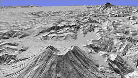
3 ArcGIS Online World Elevation & Terrain 3D for 3D Visualization ArcGIS Online World Elevation - Supports analysis & visualization - Accessed using REST calls defined by REST API (2D AOI, polyline, or points ) Terrain 3D cached elevation service - Optimized to quickly generate an oblique 3D perspective view (multiresolution) - Not intended for analysis - Automatically connected into ArcGIS Pro
4 Contents ArcGIS Online World Elevation Data sources, Functions, and Geoprocessing Services
 1 km Bathymetry (GEBCO) 250m GMTED 90 m SRTM & EarthEnv-DEM90 60 m")
 3 m (partial USA, Denmark, Finland) 2 m (partial UK) more coming")
5 World Elevation Services - Data Sources Public domain elevation data 2+ TB (LZW compressed TIF) 1 km Bathymetry (GEBCO) 250m GMTED 90 m SRTM & EarthEnv-DEM90 60 m NED (AK) 50 m OS (UK) 30 m SRTM (most of world) 30 m NED (North America) 10 m (USA, Norway, Austria) 3 m (partial USA, Denmark, Finland) 2 m (partial UK) more coming each year
 Server-side Geoprocessing (GP) services - Profile - Summary Statistics - Viewshed - Watershed (Hydro) - Trace Downstream")
6 Services (as viewed in ArcMap) Image service: elevation values & derived products - Terrain - TopoBathy - Dedicated NED 30m (USA) Server-side Geoprocessing (GP) services - Profile - Summary Statistics - Viewshed - Watershed (Hydro) - Trace Downstream (Hydro)

 9 Functions to create on-the-fly")
7 Contents World Elevation as an image service Elevation products available on demand using Raster Functions as Processing Templates Default is Terrain (orthometric height, 32 bit float) 9 Functions to create on-the-fly products
8 Modes of Use ArcGIS Online World Elevation
9 How can I use these services? Usage Modes - Visualization - Data Values - Geoprocessing Client Applications - ArcMap, ArcGIS Pro, ArcGIS Online, Custom web apps End Users vs. Developers
10 Usage Modes Visualization - Hillshade (Grayscale, Elevation Tinted) - Slope Map & Aspect Map


11 Usage Modes Visualization - Hillshade (Grayscale, Elevation Tinted) - Slope Map & Aspect Map Data Values - Orthometric & Ellipsoidal Height - for Orthorectification, Local Analysis - Slope & Aspect
 - Slope Map & Aspect Map Data Values -")

12 Usage Modes Visualization - Hillshade (Grayscale, Elevation Tinted) - Slope Map & Aspect Map Data Values - Height - Slope & Aspect Server-side Geoprocessing Services - Viewshed, Profile, Statistics, Watershed, Trace Downstream

13 Using World Elevation DEMO
14 Client Applications ArcGIS Online web map
15 Client Applications ArcGIS Online web map ArcGIS Pro, ArcMap ( or later)
16 Client Applications ArcGIS Online web map ArcGIS Pro, ArcMap ( or later) Custom web applications - Cartography - Data for elevation analysis - Custom geoprocessing - ArcGIS API s vs. OGC (WMS, WCS limited functionality)

17 Connecting and Using 1. Start in ArcGIS Online Group: Elevation Layers - Base image service is Terrain - Or choose layer preconfigured with Raster Function


18 Connecting and Using 1. Start in ArcGIS Online Group: Elevation Layers - Base image service is Terrain - Or choose layer preconfigured with Raster Function 2. Start in ArcGIS Online Web Map - Add from Living Atlas, Terrain 3. OR Start in ArcMap/ArcGIS Pro - Add Data from ArcGIS Online, Terrain
19 Connecting and Using 1. Start in ArcGIS Online Group: Elevation Layers - Base image service is Terrain - Or choose layer preconfigured with Raster Function 2. Start in ArcGIS Online Web Map - Add from Living Atlas, Terrain 3. OR Start in ArcMap/ArcGIS Pro - Add Data from ArcGIS Online, Terrain Authentication required - ArcGIS, AGOL map: - ArcGIS Online Subscription Account - Custom REST-based apps - Acquire token - Pass token in REST request

20 Add server connection into ArcMap DEMO
21 Using geoprocessing services For frequently used analytical tasks, data manager can publish geoprocessing services. No need to export a copy of the data User defines processing parameters Server extracts imagery & runs process Summary result returned to user (JPG image, table of points, feature class, etc.)
22 Geoprocessing Services
23 Details ArcGIS Online World Elevation
24 Terms of Use ArcGIS Online Subscription account Services with no cost in terms of AGOL Credits: - Image services & functions (elevation, hillshade etc.) - ElevationSync analysis: Profile Geoprocessing services that will consume Credits: - Hydrology analysis: Trace Downstream and Watershed - Elevation analysis: Profile, Summarize Elevation, and Viewshed - 1 credit per 1000 features!
25 Resources World Elevation group on ArcGIS Online: Open for questions FAQs for World Elevation services: Recorded Seminar: Elevation Analysis with ArcGIS Online For developers: AGOL elevation analysis: Export AOI: Community Elevation Contributions:


26 Please take our Survey Your feedback allows us to help maintain high standards and to help presenters Find your event in the Esri Events App Find the session you want to review Scroll down to the bottom of the session Answer survey questions and submit
Leveraging ArcGIS Online Elevation and Hydrology Services. Steve Kopp, Jian Lange
 Leveraging ArcGIS Online Elevation and Hydrology Services Steve Kopp, Jian Lange Topics An overview of ArcGIS Online Elevation Analysis Using Elevation Analysis Services in ArcGIS for Desktop Using Elevation
ArcGIS Data Reviewer: Quality Assessment for Elevation Raster Datasets. Roslyn Dunn
 ArcGIS Data Reviewer: Quality Assessment for Elevation Raster Datasets Roslyn Dunn What is ArcGIS Data Reviewer? Data Quality Management for ArcGIS Provides - Rule-based validation - Interactive tools
Creating Watersheds and Stream Networks. Steve Kopp
 Creating Watersheds and Stream Networks Steve Kopp Workshop Overview Demo Data Understanding the tools Elevation Data Types DEM : Digital Elevation Model bare Earth DSM : Digital Surface Model Data Structure
ArcGIS Data Reviewer: Assessing Positional Accuracy. Roslyn Dunn
 ArcGIS Data Reviewer: Assessing Positional Accuracy Roslyn Dunn What is ArcGIS Data Reviewer? Data Quality Management for ArcGIS Provides - Rule-based validation - Interactive tools - Track errors Validate
Working with Elevation Data Using Mosaic Datasets & Image Services. Peter Becker
 Working with Elevation Data Using Mosaic Datasets & Image Services Peter Becker OUTLINE Uses or Elevation data Requirements ArcGIS 10 capabilities - Mosaic Datasets - ArcGIS Server Best Practices Worklow
GeoSUR SRTM 30-m / TPS
 GeoSUR SRTM 30-m / TPS Wm Matthew Cushing (USGS) 16 May 2013 U.S. Department of the Interior U.S. Geological Survey SRTM Mission Shuttle Radar Topography Mission (SRTM) Space Shuttle Endeavour during the
Network Analysis with ArcGIS Online. Deelesh Mandloi Dmitry Kudinov
 Deelesh Mandloi Dmitry Kudinov Introductions Who are we? - Network Analyst Product Engineers Who are you? - Network Analyst users? - ArcGIS Online users? - Trying to figure out what is ArcGIS Online? Slides
Working with OGC WCS Services - WCS in ArcGIS. Zikang Zhou
 Working with OGC WCS Services - WCS in ArcGIS Zikang Zhou zzhou@esri.com OGC WCS introduction The Open Geospatial Consortium, Inc. (OGC) Web Coverage Service (WCS) provides an open specification for sharing
DATA APPLIANCE FOR ARCGIS
 DATA APPLIANCE FOR ARCGIS Data Appliance for ArcGIS Provides Access to Multi-Scale Basemaps Down to Medium Scale Levels Worldwide And Large Scale for Most of the World The Data Appliance includes Several
Data Aggregation with InfraWorks and ArcGIS for Visualization, Analysis, and Planning
 Data Aggregation with InfraWorks and ArcGIS for Visualization, Analysis, and Planning Stephen Brockwell President, Brockwell IT Consulting, Inc. Join the conversation #AU2017 KEYWORD Class Summary Silos
ArcGIS Runtime: Migrating Your Apps from ArcGIS Engine. Eric Bader Lucas Danzinger Mike Branscomb
 ArcGIS Runtime: Migrating Your Apps from ArcGIS Engine Eric Bader Lucas Danzinger Mike Branscomb Migrating to ArcGIS Runtime ArcGIS Engine ArcGIS Runtime AppStudio for ArcGIS Apps: Collector, Workforce,
ArcGIS Pro: Analysis and Geoprocessing. Nicholas M. Giner Esri Christopher Gabris Blue Raster
 ArcGIS Pro: Analysis and Geoprocessing Nicholas M. Giner Esri Christopher Gabris Blue Raster Agenda What is Analysis and Geoprocessing? Analysis in ArcGIS Pro - 2D (Spatial xy) - 3D (Elevation - z) - 4D
Introduction to Spatial Analysis in ArcGIS Online. Jian Lange, Vicki Lynn Cove
 Introduction to Spatial Analysis in ArcGIS Online Jian Lange, Vicki Lynn Cove Topics Introducing ArcGIS Online Spatial Analysis ArcGIS Online Spatial Analysis Workflow Demos and examples - Using ArcGIS
Working with OGC WCS. Zikang Zhou
 Working with OGC WCS Zikang Zhou zzhou@esri.com Working with OGC WCS Introduction The Open Geospatial Consortium, Inc. (OGC) Web Coverage Service (WCS) provides an open specification for sharing coverages
ArcGIS Online Routing and Network Analysis. Deelesh Mandloi Matt Crowder
 ArcGIS Online Routing and Network Analysis Deelesh Mandloi Matt Crowder Introductions Who are we? - Members of the Network Analyst development team Who are you? - Network Analyst users? - ArcGIS Online
Migrating Defense Workflows from ArcMap to ArcGIS Pro. Renee Bernstein and Jared Sellers
 Migrating Defense Workflows from ArcMap to ArcGIS Pro Renee Bernstein and Jared Sellers ArcGIS Desktop Desktop Web Device ArcMap ArcCatalog ArcScene ArcGlobe ArcGIS Pro portal Server Online Content and
Esri Production Mapping: Map Automation & Advanced Cartography MADHURA PHATERPEKAR JOE SHEFFIELD
 Esri Production Mapping: Map Automation & Advanced Cartography MADHURA PHATERPEKAR JOE SHEFFIELD Traditional Cartography What you really want Cartographic Workflow Output Cartographic Data Symbology Layout
ArcGIS Runtime: Migrating from ArcGIS Engine. Rex Hansen
 ArcGIS Runtime: Migrating from ArcGIS Engine Rex Hansen Thank You to Our Sponsors Migrating from ArcGIS Engine to ArcGIS Runtime ArcGIS Runtime API: new and evolved workflows on all platforms Windows Linux
ArcGIS Online Tools and Water-Related Web Services You Can Use Every Day of Your Life!
 ArcGIS Online Tools and Water-Related Web Services You Can Use Every Day of Your Life! Brian Rowley, PE, CFM FMA 2014 Annual Conference 1 Gold Rush (49ers) John Sutter Sutter s Mill South fork of American
Esri Defense Mapping: Cartographic Production. Bo King
 Esri Defense Mapping: Cartographic Production Bo King Agenda Esri Defense Mapping: Cartographic Production Solution Overview Desktop Cartographic Production Workflow - Create Rapid Graphic Product On Demand
Geodatabase Best Practices. Dave Crawford Erik Hoel
 Geodatabase Best Practices Dave Crawford Erik Hoel Geodatabase best practices - outline Geodatabase creation Data ownership Data model Data configuration Geodatabase behaviors Data integrity and validation
ArcGIS Enterprise: What s New. Philip Heede Shannon Kalisky Melanie Summers Sam Williamson
 ArcGIS Enterprise: What s New Philip Heede Shannon Kalisky Melanie Summers Sam Williamson ArcGIS Enterprise is the new name for ArcGIS for Server What is ArcGIS Enterprise ArcGIS Enterprise is powerful
Managing Imagery and Raster Data Using Mosaic Datasets
 Esri International User Conference San Diego, California Technical Workshops July 25, 2012 Managing Imagery and Raster Data Using Mosaic Datasets Hong Xu, Prashant Mangtani Presentation Overview Introduction
ArcGIS Earth for Enterprises DARRON PUSTAM ARCGIS EARTH CHRIS ANDREWS 3D
 ArcGIS Earth for Enterprises DARRON PUSTAM ARCGIS EARTH CHRIS ANDREWS 3D ArcGIS Earth is ArcGIS Earth is a lightweight globe desktop application that helps you explore any part of the world and investigate
Esri s Living Atlas of the World Community Maps
 Esri s Living Atlas of the World Community Maps Seth Sarakaitis Wednesday May 7, 2014 ArcGIS Living Atlas Concept Living Atlas Content Tour Contributing to the Living Atlas (Community Maps) Seth Sarakaitis
Leveraging the OGC Capabilities of ArcGIS Server
 Leveraging the OGC Capabilities of ArcGIS Server Satish Sankaran Interoperability and Standards Team Yingqi Tang Server Team Jessica Parteno Geodatabase Team ArcGIS Server is Open & Interoperable Using
Exelis and Esri Technologies for Defense and National Security. Cherie Muleh
 Exelis and Esri Technologies for Defense and National Security Cherie Muleh Cherie.Muleh@exelisinc.com ENVI IMAGERY AND DATA BECOME KNOWLEDGE > Add information from imagery to your GIS > Automated workflows
Getting Started with Community Maps
 Esri International User Conference San Diego, California Technical Workshops July 24, 2012 Getting Started with Community Maps Shane Matthews and Tamara Yoder Topics for this Session ArcGIS is a complete
Introduction to ArcGIS Server - Creating and Using GIS Services. Mark Ho Instructor Washington, DC
 Introduction to ArcGIS Server - Creating and Using GIS Services Mark Ho Instructor Washington, DC Technical Workshop Road Map Product overview Building server applications GIS services Developer Help resources
Enabling ENVI. ArcGIS for Server
 Enabling ENVI throughh ArcGIS for Server 1 Imagery: A Unique and Valuable Source of Data Imagery is not just a base map, but a layer of rich information that can address problems faced by GIS users. >
ArcGIS for Defense: Analyzing Environmental Impact on Operations. Jim Weakland John Fry Matt Funk
 ArcGIS for Defense: Analyzing Environmental Impact on Operations Jim Weakland John Fry Matt Funk Terrain and Weather Photo: U.S. Air Force/Senior Airman Areca T. Wilson Photo: Lance Cpl. Preston McDonald
SCAUG Community Maps Building a Living Atlas of the World
 SCAUG Community Maps Building a Living Atlas of the World Mark Stewart Topics: SCAUG ArcGIS Online Overview Community Maps Overview Community Maps Workflow Update Process Utilizing Your Contribution Community
Living Atlas of the World: The Road Ahead. Deane Kensok Sean Breyer
 Living Atlas of the World: The Road Ahead Deane Kensok Sean Breyer ArcGIS includes a Living Atlas of the World Maps and Layers from Esri and Thousands of Contributors The Collection is growing and changing
Portal for ArcGIS: An Introduction. Catherine Hynes and Derek Law
 Portal for ArcGIS: An Introduction Catherine Hynes and Derek Law Agenda Web GIS pattern Product overview Installation and deployment Configuration options Security options and groups Portal for ArcGIS
Esri Production Mapping: An Introduction
 Esri Production Mapping: An Introduction Amber Bethell & Joseph Sheffield Esri UC 2014 Technical Workshop Your organization s processes Collect Share Manage Produce Your organization s needs Standardization
These modules are covered with a brief information and practical in ArcGIS Software and open source software also like QGIS, ILWIS.
 Online GIS Training and training modules covered are: 1. ArcGIS, Analysis, Fundamentals and Implementation 2. ArcGIS Web Data Sharing 3. ArcGIS for Desktop 4. ArcGIS for Server These modules are covered
ArcGIS Enterprise: What s New. Philip Heede Shannon Kalisky Melanie Summers Shreyas Shinde
 ArcGIS Enterprise: What s New Philip Heede Shannon Kalisky Melanie Summers Shreyas Shinde ArcGIS Enterprise is the new name for ArcGIS for Server ArcGIS Enterprise Software Components ArcGIS Server Portal
Network Analysis Services in ArcGIS Enterprise. Deelesh Mandloi
 Network Analysis Services in ArcGIS Enterprise Deelesh Mandloi Slides from this demo theater http://esriurl.com/uc17nas Agenda Network Analyst concepts ArcGIS Enterprise publishing workflow - Geoprocessing
Local Government Basemaps using ArcGIS
 Local Government Basemaps using ArcGIS Steve Grisé Scott Oppmann Tuesday, July 14, 10:15-11:30am SDCC 30B Topics Basemaps for Local Government Essential Application-Driven New Ideas Design Strategies Discussion
Esri UC2013. Technical Workshop.
 Esri International User Conference San Diego, California Technical Workshops July 9, 2013 CAD: Introduction to using CAD Data in ArcGIS Jeff Reinhart & Phil Sanchez Agenda Overview of ArcGIS CAD Support
ArcGIS Runtime: Migrating from ArcGIS Engine
 ArcGIS Runtime: Migrating from ArcGIS Engine Rex Hansen Mike Branscomb https://community.esri.com/community/developers/native-app-developers ArcGIS Runtime session tracks at DevSummit 2018 ArcGIS Runtime
Collector for ArcGIS: Working with High Accuracy Data. Kevin Burke Morgan Zhang
 Collector for ArcGIS: Working with High Accuracy Data Kevin Burke Morgan Zhang Agenda Introduction Getting started Collector setup for high accuracy data collection Field data collection process Tools
CAD: Introduction to using CAD Data in ArcGIS. Kyle Williams & Jeff Reinhart
 CAD: Introduction to using CAD Data in ArcGIS Kyle Williams & Jeff Reinhart What we will accomplish today Overview of ArcGIS CAD Support Georeferencing CAD data for ArcGIS How Mapping Specification for
ArcGIS for Military: Analyzing the Operational Environment. Matthew Funk Carolyn Fish
 ArcGIS for Military: Analyzing the Operational Environment Matthew Funk Carolyn Fish Geospatial Enterprise for the Military Sensors Operations Server COP Mounted Intelligence Planning Provisioning Dismounted
ArcGIS for INSPIRE. Marten Hogeweg
 ArcGIS for INSPIRE Marten Hogeweg Please Take Our Survey on the App Download the Esri Events app and find your event Select the session you attended Scroll down to find the feedback section Complete answers
Web GIS Deployment for Administrators. Vanessa Ramirez Solution Engineer, Natural Resources, Esri
 Web GIS Deployment for Administrators Vanessa Ramirez Solution Engineer, Natural Resources, Esri Agenda Web GIS Concepts Web GIS Deployment Patterns Components of an On-Premises Web GIS Federation of Server
ArcGIS Earth Introduction and Deployment. Darron Pustam Product Manager Esri Jasmine Du Product Engineer Esri
 ArcGIS Earth Introduction and Deployment Darron Pustam Product Manager Esri Jasmine Du Product Engineer Esri Speaker Darron Pustam, Product Manager Esri Products ArcGIS Earth Desktop, (Android, ios) ArcGIS
Changes in Esri GIS, practical ways to be ready for the future
 Changes in Esri GIS, practical ways to be ready for the future John Sharrard, Esri April 16, 2015 The only thing that is constant is change. Heraclitus, ca. 500 B.C. My story (of experiencing change) Changes
ArcGIS Web Tools, Templates, and Solutions for Defence & Intelligence. Renee Bernstein Esri Solutions Engineer
 ArcGIS Web Tools, Templates, and Solutions for Defence & Intelligence Renee Bernstein Esri Solutions Engineer ArcGIS Solutions Includes 450+ Industry Focused Apps and Capabilities Organized by 9 Primary
Demystifying ArcGIS Online. Karen Lizcano Esri
 Demystifying ArcGIS Online Karen Lizcano Esri An Integrated Web GIS Platform Desktop Web Device Powered by Services Managed via Portal Access from any Device Portal Server Online Content and Services ArcGIS
Image Services Providing Access to Scientific Data at NOAA/NCEI
 Image Services Providing Access to Scientific Data at NOAA/NCEI Jesse Varner Cooperative Institute for Research in Environmental Sciences (CIRES), University of Colorado John Cartwright NOAA National Centers
ArcGIS Pro Q&A Session. NWGIS Conference, October 11, 2017 With John Sharrard, Esri GIS Solutions Engineer
 ArcGIS Pro Q&A Session NWGIS Conference, October 11, 2017 With John Sharrard, Esri GIS Solutions Engineer jsharrard@esri.com ArcGIS Desktop The applications ArcGIS Pro ArcMap ArcCatalog ArcScene ArcGlobe
Esri Training by Microcenter Prepare to Innovate. Microcenter Course Catalog
 Esri Training by Microcenter Prepare to Innovate 2015 Instructor-Led Courses Microcenter Course Catalog ArcGIS Foundational Courses Designed to meet the learning needs of professionals whose GIS experience
ArcGIS 10.0 Imagery. Joseph B. Bowles
 ArcGIS 10.0 Imagery Joseph B. Bowles Presentation Overview Imagery and raster data What is a mosaic dataset Use of mosaic datasets Build a mosaic dataset Migrate to mosaic datasets Q&A Characteristics
ArcGIS Pipeline Referencing An Introduction. Anjali Bhangay William Isley
 ArcGIS Pipeline Referencing An Introduction Anjali Bhangay William Isley Pipeline Referencing Overview Information Model Pipeline Referencing Overview Information Model ArcGIS Pro Pipeline Referencing
Introduction to Portal for ArcGIS. Hao LEE November 12, 2015
 Introduction to Portal for ArcGIS Hao LEE November 12, 2015 Agenda Web GIS pattern Product overview Installation and deployment Security and groups Configuration options Portal for ArcGIS + ArcGIS for
September 2016 New ArcGIS Solutions
 September 2016 New ArcGIS Solutions Hydroelectric https://profservices.maps.arcgis.com/apps/mapjournal/index.html?appid=0ef98f74f8fb4f9da88 1adc521e1c90f Adopta Engage the public in the maintenance and
Python Raster Analysis. Kevin M. Johnston Nawajish Noman
 Python Raster Analysis Kevin M. Johnston Nawajish Noman Outline Managing rasters and performing analysis with Map Algebra How to access the analysis capability - Demonstration Complex expressions and optimization
Geospatial Standards Support - An Overview. Marten Hogeweg & Satish Sankaran
 Geospatial Standards Support - An Overview Marten Hogeweg & Satish Sankaran Agenda Interoperability and Standards ArcGIS Open, Interoperable and Standards Compliant Esri Open initiatives Understanding
ArcGIS Data Reviewer Advanced Data Validation Concepts. Francisco Perez & Shankar Chandrasekaran
 ArcGIS Data Reviewer Advanced Data Validation Concepts Francisco Perez & Shankar Chandrasekaran rkshop Agenda Importance of Data Quality What is ArcGIS Data Reviewer? Automated Validation Extending Automated
Migrating to ArcGIS Runtime 100.0
 Migrating to ArcGIS Runtime 100.0 Eric Bader Mike Branscomb @ArcGISRuntime Migrating to ArcGIS Runtime 100.0 ArcGIS Runtime 10.2.x ArcGIS Engine ArcGIS Runtime SDK for Windows Mobile ArcGIS Explorer SDK
Creating Watersheds from a DEM
 Creating Watersheds from a DEM These instructions enable you to create watersheds of specified area using a good quality Digital Elevation Model (DEM) in ArcGIS 8.1. The modeling is performed in ArcMap
Performing Advanced Cartography with Esri Production Mapping
 Esri International User Conference San Diego, California Technical Workshops July 25, 2012 Performing Advanced Cartography with Esri Production Mapping Tania Pal & Madhura Phaterpekar Agenda Outline generic
ArcGIS Earth an Intro
 ArcGIS Earth an Intro Chris Andrews Product Manager, 3D and ArcGIS Earth Brian Sims 3D Content Lead 3D across the Esri product family ArcGIS Pro 3D Analyst CityEngine ArcGIS for Server ArcGIS Online ArcGIS
Innovation. The Push and Pull at ESRI. September Kevin Daugherty Cadastral/Land Records Industry Solutions Manager
 Innovation The Push and Pull at ESRI September 2004 Kevin Daugherty Cadastral/Land Records Industry Solutions Manager The Push and The Pull The Push is the information technology that drives research and
No. of Days. ArcGIS 3: Performing Analysis ,431. Building 3D cities Using Esri City Engine ,859
 What s New? Creating Story Maps with ArcGIS Field Data Collection and Management Using ArcGIS Get Started with Insights for ArcGIS Introduction to GIS Using ArcGIS & ArcGIS Pro: Essential Workflow Migrating
No. of Days. ArcGIS Pro for GIS Professionals ,431. Building 3D cities Using Esri City Engine ,859
 What s New? Creating Story Maps with ArcGIS Field Data Collection and Management Using ArcGIS Get Started with Insights for ArcGIS Introduction to GIS Using ArcGIS & ArcGIS Pro: Essential Workflow Migrating
Using CAD data in ArcGIS
 Using CAD data in ArcGIS Phil Sanchez and Jeff Reinhart Esri UC 2014 Technical Workshop Agenda Overview of ArcGIS CAD Support Using CAD Datasets in ArcMap Georeferencing CAD data for ArcGIS Loading CAD
Using netcdf and HDF in ArcGIS. Nawajish Noman Dan Zimble Kevin Sigwart
 Using netcdf and HDF in ArcGIS Nawajish Noman Dan Zimble Kevin Sigwart Outline NetCDF and HDF in ArcGIS Visualization and Analysis Sharing Customization using Python Demo Future Directions Scientific Data
The File Geodatabase API. Craig Gillgrass Lance Shipman
 The File Geodatabase API Craig Gillgrass Lance Shipman Schedule Cell phones and pagers Please complete the session survey we take your feedback very seriously! Overview File Geodatabase API - Introduction
Leveraging Web GIS: An Introduction to the ArcGIS portal
 Leveraging Web GIS: An Introduction to the ArcGIS portal Derek Law Product Management DLaw@esri.com Agenda Web GIS pattern Product overview Installation and deployment Configuration options Security options
Working with ArcGIS Online
 Esri International User Conference San Diego, CA Technical Workshops July 12, 2011 Working with ArcGIS Online Bern Szukalski, Deane Kensok Topics for this Session ArcGIS Online Overview ArcGIS Online Content
Law Enforcement Solutions and Applications
 ArcGIS for Solutions and Applications Solutions and Applications ArcGIS for Platform ArcGIS for Collection of solutions and applications for law enforcement. Built on the ArcGIS platform. For any named
Map Services Are We Getting It?
 Map Services Are We Getting It? Rich Herrmann VP Global Platforms & Technology, IHS James Sanders Senior Product Manager, IHS April 19, 2011 Houston, TX USA Overview The Challenge Keith Fraley s 2010 PUG
Introduction to ArcGIS Server Development
 Introduction to ArcGIS Server Development Kevin Deege,, Rob Burke, Kelly Hutchins, and Sathya Prasad ESRI Developer Summit 2008 1 Schedule Introduction to ArcGIS Server Rob and Kevin Questions Break 2:15
Administering your Enterprise Geodatabase using Python. Jill Penney
 Administering your Enterprise Geodatabase using Python Jill Penney Assumptions Basic knowledge of python Basic knowledge enterprise geodatabases and workflows You want code Please turn off or silence cell
ArcGIS is Advancing. Both Contributing and Integrating many new Innovations. IoT. Smart Mapping. Smart Devices Advanced Analytics
 ArcGIS is Advancing IoT Smart Devices Advanced Analytics Smart Mapping Real-Time Faster Computing Web Services Crowdsourcing Sensor Networks Both Contributing and Integrating many new Innovations ArcGIS
Introduction to Portal for ArcGIS
 Introduction to Portal for ArcGIS Derek Law Product Management March 10 th, 2015 Esri Developer Summit 2015 Agenda Web GIS pattern Product overview Installation and deployment Security and groups Configuration
ArcGIS Maps for Power BI An Introduction. DJ Berry Scott Ball
 ArcGIS Maps for Power BI An Introduction DJ Berry Scott Ball Agenda Introduction to ArcGIS Maps for Power BI ArcGIS Maps for Power BI overview Esri + Microsoft = Better Together Visualizing Power BI data
A Vision for ArcGIS Applying Geography Everywhere
 A Vision for ArcGIS Applying Geography Everywhere WELCOME PURPOSE A Network of GIS Professionals Are Awakening the World to the Power of Web GIS You Your WORK Making a Difference Your Work Open Maps and
Data Aggregation with InfraWorks and ArcGIS for Visualization, Analysis, and Planning
 CI125230 Data Aggregation with InfraWorks and ArcGIS for Visualization, Analysis, and Planning Stephen Brockwell Brockwell IT Consulting Inc. Sean Kinahan Brockwell IT Consulting Inc. Learning Objectives
A Geographer s role in a Google Maps World. Jeremy Bartley ESRI
 A Geographer s role in a Google Maps World Jeremy Bartley ESRI 1 It is a good time to be a Geographer. 2 Microsoft, Google, Yahoo, and others are pushing geographic awareness to the general public Providing
ArcGIS. for Server. Understanding our World
 ArcGIS for Server Understanding our World ArcGIS for Server Create, Distribute, and Manage GIS Services You can use ArcGIS for Server to create services from your mapping and geographic information system
Portal for ArcGIS: An Introduction
 Portal for ArcGIS: An Introduction Derek Law Esri Product Management Esri UC 2014 Technical Workshop Agenda Web GIS pattern Product overview Installation and deployment Security and groups Configuration
Geospatial Fire Behavior Modeling App to Manage Wildfire Risk Online. Kenyatta BaRaKa Jackson US Forest Service - Consultant
 Geospatial Fire Behavior Modeling App to Manage Wildfire Risk Online Kenyatta BaRaKa Jackson US Forest Service - Consultant Fire Behavior Modeling and Forest Fuel Management Modeling Fire Behavior is an
Introduction to ArcGIS Maps for Office. Greg Ponto Scott Ball
 Introduction to ArcGIS Maps for Office Greg Ponto Scott Ball Agenda What is Maps for Office? Platform overview What are Apps for the Office? ArcGIS Maps for Office features - Visualization - Geoenrichment
GIS CONCEPTS ARCGIS METHODS AND. 3 rd Edition, July David M. Theobald, Ph.D. Warner College of Natural Resources Colorado State University
 GIS CONCEPTS AND ARCGIS METHODS 3 rd Edition, July 2007 David M. Theobald, Ph.D. Warner College of Natural Resources Colorado State University Copyright Copyright 2007 by David M. Theobald. All rights
Enabling Web GIS. Dal Hunter Jeff Shaner
 Enabling Web GIS Dal Hunter Jeff Shaner Enabling Web GIS In Your Infrastructure Agenda Quick Overview Web GIS Deployment Server GIS Deployment Security and Identity Management Web GIS Operations Web GIS
Map Application Progression
 Map Application Progression Application Migration with Latest ArcGIS by Dean Chiang California Department of Fish and Wildlife What we do at CDFW Hunting and fishing licensing and regulation Conservation
ELF products in the ArcGIS platform
 ELF products in the ArcGIS platform Presentation to: Author: Date: NMO Summit 2016, Dublin, Ireland Clemens Portele 18 May 2016 The Building Blocks 18 May, 2016 More ELF users through affiliated platforms
Web GIS & ArcGIS Pro. Zena Pelletier Nick Popovich
 Web GIS & ArcGIS Pro Zena Pelletier Nick Popovich Web GIS Transformation of the ArcGIS Platform Desktop Apps GIS Web Maps Web Scenes Layers Evolution of the modern GIS Desktop GIS (standalone GIS) GIS
ArcGIS Data Models: Raster Data Models. Jason Willison, Simon Woo, Qian Liu (Team Raster, ESRI Software Products)
") ArcGIS Data Models: Raster Data Models Jason Willison, Simon Woo, Qian Liu (Team Raster, ESRI Software Products) Overview of Session Raster Data Model Context Example Raster Data Models Important Raster
ArcGIS Data Models: Raster Data Models Jason Willison, Simon Woo, Qian Liu (Team Raster, ESRI Software Products) Overview of Session Raster Data Model Context Example Raster Data Models Important Raster
Esri WebGIS Highlights of What s New, and the Road Ahead
 West Virginia GIS Conference WVU, Morgantown, WV Esri WebGIS Highlights of What s New, and the Road Ahead Mark Scott, Solutions Engineer, Esri Local Government Team May 5 th, 2016 West Virginia GIS Conference
Methodological Chain for Hydrological Management with Web-GIS Applications
 Advances in Geosciences Konstantinos Perakis & Athanasios Moysiadis, Editors EARSeL, 2012 Methodological Chain for Hydrological Management with Web-GIS Applications Alexandros Konstantinidis 1, Eleni Tzanou
Leveraging the GIS Capability within FlexiCadastre
 Managing Local Land Concerns, Maintaining Corporate Governance Leveraging the GIS Capability within FlexiCadastre Regional User Conference, North America May 6 th May 9 th, 2013 Cameron McKellar, Technical
Understanding elevation and derivative layers
 Understanding elevation and derivative layers ArcGIS makes it easy to work with elevation data by offering a dynamic world elevation service (TopoBathy) and a specific land elevation (Terrain). These services
Creating Basemaps to Manage Buildings and Facilities
 Esri International User Conference San Diego, California Technical Workshops July 26, 2012 Creating Basemaps to Manage Buildings and Facilities Mark Stewart and Tamara Yoder Topics for this Session Overview
What s New in Topographic Information - USGS National Map
 + What s New in Topographic Information - USGS National Map SARGIS Workshop November 14, 2016 Rob Dollison, 703-648-5724 rdollison@usgs.gov + USGS 2 National Geospatial Program The National Geospatial
Overview of ArcGIS Enterprise August 24, Dan Haag ESRI
 Overview of ArcGIS Enterprise August 24, 2017 Dan Haag ESRI Sharing to a portal ArcGIS 10.3 portal Central destination for all of your geospatial assets in Web GIS - ArcGIS Online organization and/or Portal
Introduction to ArcGIS Defense Solutions
 Introduction to ArcGIS Defense Solutions Military Analyst and Military Overlay Editor (MOLE) Presented by Candace Paulman, ESRI Federal User Conference 2008 3 ArcGIS Defense Solutions Logistics Cell phones