Create a Topographic Profile of Beacon Valley
|
|
|
- Avice Butler
- 6 years ago
- Views:
Transcription


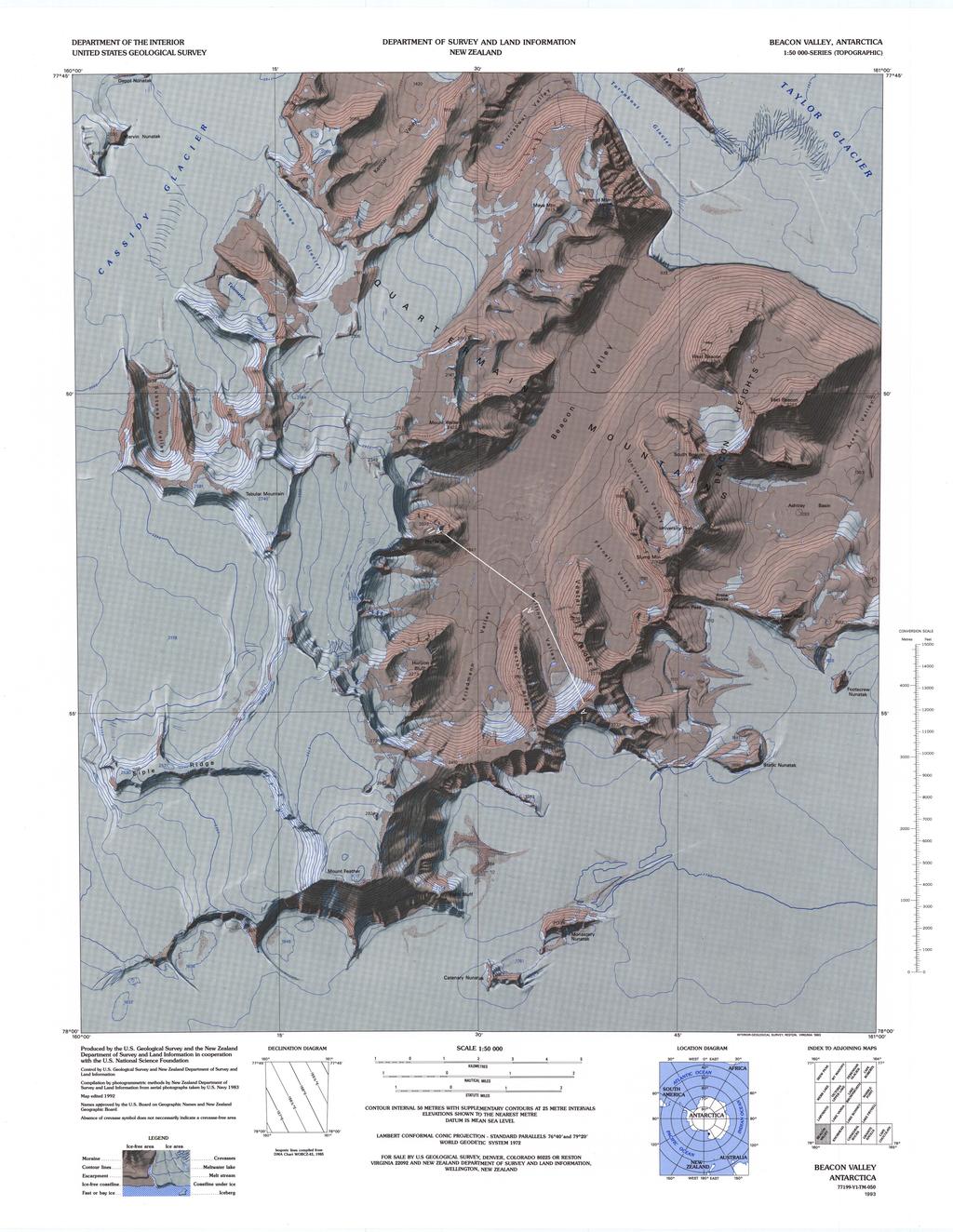
1 Details Create a Topographic Profile of Beacon Valley Completion Time: About a week Permission: Download, Share, and Remix Overview Beacon Valley is recognized by scientists as one of the most Mars-like environments on Earth. This lesson plan was created so that students could have the opportunity to examine the same landforms that scientists use to study the processes that operate in both of these extreme environments. There are two parts to this lesson. Teachers may choose to use one part or the entire lesson depending on the grade level. Objectives The goal of this lesson is two-fold: (1) to construct a topographic profile and identify the glacial landforms using the landscape of Beacon Valley, Antarctica; and (2) compare those landforms with similar landforms on Mars. Materials High speed computers to access websites and download images. 3-D glasses Stereoscopes (optional, depending on grade level) Images & Files (Download with lesson, see Resources section for others) At the end of this lesson students will be able to: Construct and interpret a topographic profile. Identify glacial landforms in Beacon Valley; Compare and contrast glacial landforms in Beacon Valley with those on Mars. Lesson Preparation Before assigning this lesson, the following content should be covered. For students: Students should read science/geology textbooks for a discussion on polygon formation before completing this lesson. This discussion is typically found in chapters on glaciers and may be discussed under patterned ground. For students and teachers: Both students and teachers should read the following pages in Jackie Hams journals on the PolarTREC website at: 1
2 30 November 2008 A Tale of Two Planets 22 November 2008 Return to Mac Town Ask the Team section of Jackie s expedition page - Post on polygons For teachers: Teachers should lecture on polygon formation before assigning this lesson to students. The lesson plan consists of Parts I and II. The content of Parts I and II is as follows: I. Students will construct a topographic profile across Beacon Valley, Antarctica and label the glacial features on the profile. II. Students will examine groups of photographs of glacial features taken in Beacon Valley and compare them with the images obtained of the same features on Mars and answer questions provided by the teacher. Procedure Part I. Create a Topographic Map Profile 1. Two topographic maps have been provided for the students. Print out the Beacon Valley topographic map and the Beacon Valley topographic map with profile line (attached). The minimum paper size that should be used to print the maps is the legal size (81/2 x 14). 11 x 14 paper can be used if available. Option: Depending on the grade level, students can create their own topographic maps and print them directly from the NASA Lima website at Teachers can use the help menu for instructions. Note that the site is fluid and image menus and instructions are periodically updated. 2. Print out copies of the BlankTopoProfile.pdf. The profile can be printed on 8 ½ x 11 paper in landscape view or on legal sized paper 8 ½ x Label the topographic end points on your blank profile (A, A and A ). The end points on the blank profile should match up with the end points on the map when you overlay the blank profile. Endpoint A has been added to the blank profile as a guide. 4. Complete the topographic profile along the section line and label the following features: Mullins Glacier Bigfoot Mullins Valley Beacon Valley 2
3 Profile Bluff Polygons in Beacon Valley (the valley floor is covered with polygons). Students can use the LIMA site to zoom in and identify features. The site works best with Firefox. To view the map features do the following: Go to Select Find Antarctic Feature Select Try it now Type Beacon Valley in the box labeled Feature Name Select Beacon Valley Select View Feature in LIMA on right You can zoom in on Beacon Valley and read the names of the features using the magnifying glass under the Tools menu. You can also change views by using selecting Orthoimagery on the right to view the topographic maps. Selecting Satellite Imagery will provide an aerial photograph of Beacon Valley. You can use the transparency tool to overlay the topographic map on the aerial photograph. Note: Teachers can contact me for a completed topographic profile to use as an answer key at hamsje@lavc.edu. Part II Photograph Interpretation Background reading: Textbook reading on polygons or patterned ground in the chapters on glaciers. Websites: (Faces of Antarctica) (Mars High Resolution Imaging Science Experiment) article on Formation of gullies on Mars There are two groups of photographs below. Students should review the group photographs and answer the questions provided for each group. Note: Students can access the photographs via the HiRISE website by typing the photograph number in the Observation ID box under the search menu. Photos are also found in the PowerPoint available with this lesson. Group 1 Photographs: Polygons a. Photograph of polygons in Beacon Valley b. Photograph of polygons on Mars (Photograph SP_007372_2475PolygonsMars). c. Close-up photograph of polygons on Mars that includes a scale (PSP_007372_2475). 3
4 Questions 1. Describe the process of polygon formation in Beacon Valley. 2. What is the approximate diameter of the polygons in the Beacon Valley photograph? 3. Can you estimate the approximate diameter of the polygons in the Mars photo? Group 2 Photographs: Holes, Holes, and more Holes a. Photograph of Bigfoot in Beacon Valley b. Photograph of beheaded glaciers on Mars. (PSP_001842_1395BigfootMars. Teachers and students should read the article on Formation of gullies on Mars at: c. Photograph of scallops on Mars (PSP _002070_2250). Students will need the red and green 3-D glasses to see the scallops in 3-D. Option: Depending on the grade level, teachers may wish to print out stereo pairs instead of using 3-D glasses. Go to the HiRISE site and search for the observation ID (PSP _002070_2250) to obtain the original image. On the main page of the image, you will find a link on the right to print out stereo pairs. Questions 1. Describe how bigfoot is formed in Beacon Valley. 2. Highlight/outline the beheaded glaciers in the Mars photograph. 3. How are beheaded glaciers on Mars formed? 4. How are the scalloped depressions on Mars formed? 5. What process is instrumental in the formation of these holes in Beacon Valley and Antarctica? Extension Extension Questions for further research 1. Since polygons on earth are cemented by ice, what does that tell you about polygons on Mars? 2. What is the significance of water related features on Mars? 3. What type of life forms would you expect to find on Mars? Resources PowerPoint with images (attached) Note: Students can access the Mars photographs directly and obtain detailed information on the images by going to the HiRISE site at Select the search feature at the top of the screen and type the PSP number in the observation ID box. Other Resources: (Faces of Antarctica) (Mars High Resolution Imaging Science Experiment) Video on overview page of journal titled Dr. Marchant explains the significance of sampling 4
5 in Beacon Valley in this video. Read the article Formation of gullies on Mars: Link to recent climate history and insolation microenvironments implicate surface water flow origin, Proceedings of the National Academy of Science (PNAS) Assessment See attached Rubric. Credits This lesson plan was created by Jacquelyn Hams, Please credit photographs and images where appropriate. 5
6 National Science Education Standards (NSES): Content Standards, Grades 5-8 Content Standard A: Science As Inquiry a. Abilities necessary to do scientific inquiry b. Understandings about scientific inquiry Content Standard D: Earth and Space Science a. Structure of the earth system b. Earth s history c. Earth in the solar system Content Standard E: Science and Technology a. Abilities of technological design b. Understandings about science and technology Content Standard F: Science In Personal and Social Perspectives e. Science and technology in society Content Standard G: History and Nature of Science a. Science as a human endeavor b. Nature of science Content Standards, Grades 9-12 Content Standard A: Science As Inquiry a. Abilities necessary to do scientific inquiry b. Understandings about scientific inquiry Content Standard E: Science and Technology a. Abilities of technological design b. Understandings about science and technology Content Standard F: Science In Personal and Social Perspectives f. Science and technology in local, national, and global challenges Content Standard G: History and Nature of Science a. Science as a human endeavor b. Nature of scientific knowledge Other Standards: California State Standards: Grades 9-12 Earth Science Content Standards 6
7 Investigation and Experimentation ESIE1. Scientific progress is made by asking meaningful questions and conducting careful investigations. As a basis for understanding this concept and addressing the content in the other three reporting clusters, students should develop their own questions and perform investigations. Students will: ESIE1. d. Formulate explanations by using logic and evidence. ESIE1.h. Read and interpret topographic and geologic maps. ESIE1. i. Analyze the locations, sequences, or intervals that are characteristic of natural phenomena (e.g. relative ages of rocks, locations of planets over time, and succession of species in an ecosystem). Earth s Place in the Universe ES1. Astronomy and planetary exploration reveal the structure, scale, and change of the solar system over time. Structure and Composition of the Atmosphere ES8. Life has changed Earth s atmosphere, and changes in the atmosphere affect conditions for life. 7
8
9
10 Topographic Profile Part I Rubric This rubric is designed for the topographic profile in Part I of the lesson plan. Advanced Proficient Topographic profile is well constructed and neatly labeled. All contour lines and profile end points are correctly marked in the appropriate intervals on the topographic profile. All glacial features are clearly and neatly labeled in the correct location. There are no errors in the topographic profile construction or labeled features. Proficient Partially Proficient Not Proficient Topographic profile is well constructed and neatly labeled. Contour lines and profile end points are correctly marked in the appropriate intervals on the topographic profile. Glacial features are clearly and neatly labeled in the correct location. There are minor errors in the topographic profile construction or labeled features. Topographic profile is constructed and labeled. Contour lines and profile end points are marked in intervals on the topographic profile. Glacial features are labeled. There are errors in the topographic profile construction or labeled features. Topographic profile is poorly constructed and improperly labeled. Contour lines and profile end points are incorrectly marked on the topographic profile. Glacial features are incorrectly labeled. There are major errors in the topographic profile construction or labeled features. 1
11 Topographic Profile Part II Rubric This rubric is designed for the questions in Part II of the lesson plan. Advanced Proficient Proficient Partially Proficient Complete and correct responses to all questions. Appropriate scientific terminology is used correctly in all answers. The correct mathematical and numerical units are used and numerical values are correct. In-depth understanding of the scientific concepts applicable to the questions is demonstrated. Thorough understanding of the connection between glaciation on Earth and Mars is demonstrated. Correct use of English and grammar in all answers. Complete and correct response to most questions. Appropriate scientific terminology is used in answers. There are minor omissions/errors that do not detract from the overall answer. The correct mathematical and numerical units are used and numerical values are correct. There are minor omissions/errors that do not detract from the overall answer. Understanding of the scientific concepts applicable to the questions is demonstrated. There are minor omissions/errors that do not detract from the overall answer. Understanding of the connection between glaciation on Earth and Mars is demonstrated. Correct use of English and grammar in the answers. There are minor omissions/errors that do not detract from the overall answer. Complete and correct response to at least 4 questions. Scientific terminology is used in answers, but there are major omissions/errors. The mathematical and numerical units used are partially correct. Numerical values are partially correct and there are major omissions and errors. Limited understanding of the scientific concepts applicable to the questions is demonstrated. Limited understanding of the connection between glaciation on Earth and Mars is demonstrated, Partially correct use of English and grammar in the answers. Not Proficient Incomplete and incorrect response to 4 questions or less. Scientific terminology is missing or incorrect. The mathematical and numerical units used are incorrect. Numerical values are incorrect. Explanation shows no understanding of the scientific concepts. Explanation shows no understanding of the connection between glaciation on Earth and Mars. Responses contain major English and grammar errors. 2
Arctic Impacts. Details. Materials. Learning Resources
 Details Learning Resources Completion Time: About one period Permission: Download, Share, and Remix Arctic Impacts Overview Lake El gygytgyn (67. o N, 17 o E) is one of the best preserved large asteroid
Looking at Communities: Comparing Urban and Rural Neighborhoods
 Looking at Communities: Comparing Urban and Rural Neighborhoods OVERVIEW & OBJECTIVES Our urban areas have become so dominant that frequently the children we teach have no connection with and very few
ROVERQUEST: Greetings from Gusev
 Mars Exploration Rover: Mars for Educators: Roverquest http://marsrovers.jpl.nasa.gov/classroom/roverquest/lesson02pr... ROVERQUEST: Greetings from Gusev EDUCATIONAL OBJECTIVE: This activity will place
CURRICULUM TR AILING ICE AGE M YST ERI E S
 MIDDLE SCHOOL CURRICULUM TR AILING ICE AGE M YST ERI E S THE Driftless Area CONTENTS I. Enduring Knowledge... 3 II. Teacher Background... 3 III. Before Viewing the Video... 5 IV. Viewing Guide... 5 V.
The Mystery of the Destroyed Weather Station
 Details Learning Resources Completion Time: Less than a week Permission: Download and Share The Mystery of the Destroyed Weather Station Overview: Students use data and pictures of a destroyed wind sensor,
Approximate Proxies. Details. Materials. Learning Resources
 Details Learning Resources Completion Time: Less than a week Permission: Download, Share, and Remix Approximate Proxies Overview The sediment in Lake El gygytgyn, (pronounced EL-ge- GIT-gin) located in
Geology Brochures Grade : Sixth An integrated lesson plan covering 5 sessions of approximately 1 hour each.
 Geology Brochures Grade : Sixth An integrated lesson plan covering 5 sessions of approximately 1 hour each. Lesson-Planning Approach Some learners perceive their world as a whole, where all things are
8 th Grade Earth and Space Science Megan Seivert, Virginia Standards of Learning Connections: Lesson Summary:
 Virginia Standards of Learning Connections: Content: Grade 8 SOL for Earth and Space Science ES.3 Earth and Space Systems -Position of Earth in the solar system -Characteristics of the sun, planets and
School Program Name: Name of Sanctuary: Grade Level: Grades 6 8 Location Options: Time:
 School Program Name: Name of Sanctuary: Grade Level: Grades 6 8 Location Options: Time: For more info: Landforms of New England Moose Hill Wildlife Sanctuary At the sanctuary 2 hours or combine with another
EARTH/SPACE SCIENCE. Earth Materials and Changes
 EARTH/SPACE SCIENCE This Earth/Space science course is designed to continue student investigations of the earth sciences that began in grades K-8 while providing students the experiences and necessary
Galactic Census: Population of the Galaxy grades 9 12
 Galactic Census: Population of the Galaxy grades 9 12 Objective Introduce students to a range of celestial objects that populate the galaxy, having them calculate estimates of how common each object is
Investigating Factors that Influence Climate
 Investigating Factors that Influence Climate Description In this lesson* students investigate the climate of a particular latitude and longitude in North America by collecting real data from My NASA Data
Measuring Ice Like NASA Does!
 Details Arctic / Antarctic About 1 Period Download, share, and remix Middle School and Up Measuring Ice Like NASA Does! Overview One of the most important indicators of our warming climate is the extent
My Map Activity MINNESOTA SOCIAL STUDIES STANDARDS & BENCHMARKS
 My Map Activity OVERVIEW & OBJECTIVES Students will learn the basics of Google Maps while using geospatial data to create their neighborhood map with the places they spend time. They will also collect
MARS PUBLIC MAPPING PROJECT (MP)2
2") KWL Prior Knowledge/Engagement Activity In your small group, brainstorm ideas about what you think you know about geologic features that may be found on Mars. Also include what questions you have about
KWL Prior Knowledge/Engagement Activity In your small group, brainstorm ideas about what you think you know about geologic features that may be found on Mars. Also include what questions you have about
Earth Science. Lessons: 15% Quizzes: 25% Projects: 30% Tests: 30% Assignment Weighting per Unit Without Projects. Lessons: 21% Quizzes: 36% Tests: 43%
 Earth Science Earth Science explores Earth s structure, interacting systems, and place in the universe. The course covers concepts and processes found in: Astronomy Earth s place in and interaction with
Planetary Real Estate
 Planetary Real Estate http://questgarden.com/18/94/4/060329145856/index.htm Focus on Inquiry The student will focus on inquiry by gathering information on a planet, comet, moon, or asteroid of their choice
Sample extended field-based investigation assessment task
 Earth Science Sample assessment Sample extended field-based investigation assessment task Compiled by the Redlands College 2007 About this task This sample is intended to be a guide to help teachers plan
Lesson 9 Overview. DRIVING QUESTION: What is the greenhouse effect and how does it affect Earth s surface temperature?
 Lesson 9 Overview DRIVING QUESTION: What is the greenhouse effect and how does it affect Earth s surface temperature? LEARNING GOAL: Students develop and use models of the greenhouse effect to construct
Subject: Science Course Title: Earth & Grade Level(s): 8th
: 8th") Teacher: Mike Valenti School: Mt. Tabor Middle School Subject: Science Course Title: Earth & Grade Level(s): 8th Space Is high school credit an option for this course? Yes X No Prerequisites: None Course
Teacher: Mike Valenti School: Mt. Tabor Middle School Subject: Science Course Title: Earth & Grade Level(s): 8th Space Is high school credit an option for this course? Yes X No Prerequisites: None Course
Inquiry Based Instruction Unit. Virginia Kromhout
 Inquiry Based Instruction Unit Virginia Kromhout Unit Title: _Exploring the moon Grade level: _2 grade nd Subject Area: _Science Topic: The Universe Key Words: Moon, lunar surface Designed By: Virginia
21CLD Learning Activity Description
 Learning Activity Example: Olympics Site Selection 1 21CLD Learning Activity Description 1. Title of Learning Activity & Average Age of Students Title: Olympics Site Selection Average Age of Students:
ESSENTIAL QUESTION How can we use the Mars Map and photographs of Mars to learn about the geologic history of the planet?
 GRADE LEVEL(S) 4 6 LENGTH 60 minutes MATERIALS Giant Destination Mars Map Mars Mapping Student Sheet Colored Markers (red, green, blue) VOCABULARY Crater Erode Ejecta Channel Sun Angle Sequence ESSENTIAL
SYLLABUS FORM WESTCHESTER COMMUNITY COLLEGE Valhalla, NY lo CURRENT DATE: Please indicate whether this is a NEW COURSE or a REVISION:
 SYLLABUS FORM WESTCHESTER COMMUNITY COLLEGE Valhalla, NY lo595 l. Course #: 2. NAME OF ORIGINATOR /REVISOR: PHYSC 143 Laurel Senft, Rob Applebaum, Eryn Klosko NAME OF COURSE Earth Science 3. CURRENT DATE:
OAKLYN PUBLIC SCHOOL
 Content Area: Science OAKLYN PUBLIC SCHOOL Unit Title: Unit C - Earth and Beyond Target Course/Grade Level: Fourth Grade Unit Summary: The Earth is in constant change. Earth s materials, such as rocks
High School. Prentice Hall. Earth Science, (Tarbuck) Indiana s Revised Academic Standards for Earth and Space Science I / 3044 (High School)
 Indiana s Revised Academic Standards for Earth and Space Science I / 3044 (High School)") Prentice Hall Earth Science, (Tarbuck) 2009 High School C O R R E L A T E D T O Students should understand that scientific knowledge is gained from observation of natural phenomena and experimentation,
Prentice Hall Earth Science, (Tarbuck) 2009 High School C O R R E L A T E D T O Students should understand that scientific knowledge is gained from observation of natural phenomena and experimentation,
GCSE GEOGRAPHY SPECIFICATION A
 Please write clearly in block capitals. Centre number Candidate number Surname Forename(s) Candidate signature GCSE GEOGRAPHY SPECIFICATION A Higher Tier Unit 1 Physical Geography H Tuesday 24 May 2016
National Center for Atmospheric Research: Climate Discovery Teacher s Guide
 Lesson Summary Students use a photo of the Bhutan glaciers in order to investigate the different effects albedo has on solar absorption. Prior Knowledge & Skills Graphing skills Data collection skills
Playing With Mud: Sediment Deposition by Tidewater Glaciers
 Details Arctic About one period Download, share, and remix Middle School and Up Playing With Mud: Overview This lesson is based on studies completed by undergraduate geoscience students working around
Earth Systems Curriculum
 Earth Systems Curriculum Course Description This course provides the opportunity to develop knowledge and understanding about the relationships between the structure, processes, and resources on Earth
Just How Big Is Our Solar System?
 Joseph Murray November 8-9, 2012 Just How Big Is Our Solar System? Purpose: Use a 5-E Learning Model to have students investigate the relative sizes and distances between our planets. The 5-E Learning
Institute for Global Environmental Strategies: Discover Earth Program Materials
 Lesson Summary Students will use either a computer interface or a thermometer and graph paper to learn about the different absorption properties of different albedos. Prior Knowledge & Skills Graphing
HAZLETON AREA SCHOOL DISTRICT DISTRICT UNIT/LESSON PLAN
 HAZLETON AREA CHOOL DTRCT DTRCT UNT/LEON PLAN Teacher Name : Melissa teber ubject : cience tart Date(s): 3/29/16 Grade Level (s): 5 th / Chapter 6 Building : DEM Unit Title: Chapter 6: Earth s Changing
SCIENCE Subject Area
 ACALANES UNION HIGH SCHOOL DISTRICT Adopted: 6/4/03 SCIENCE Subject Area COURSE TITLE: Geology COURSE CODE: S0704P GRADE LEVEL: Grades 10-12 COURSE LENGTH: 1 year PREREQUISITE: Biology CREDIT: 10 units
Tracking Sunspots. Overview: Objectives: Lesson Preparation: Procedure: Details. Materials. Standards
 Tracking Sunspots Overview: Students will examine sunspots and track them at different latitudes on the Sun. This activity is adapted from the Tracking Sunspots activity on NASA s Solar and Heliocentric
Welcome to PolarConnect. With Kelly McCarthy and NASA s Operation IceBridge
 Welcome to PolarConnect With Kelly McCarthy and NASA s Operation IceBridge 5 May 2016 If you are joining by phone, please mute your phone. Press *6 to mute and *6 to unmute. Participant Introductions In
MIDDLE SCHOOL CYCLING OF EARTH S MATERIALS
 3D Science Performance Assessment Tasks MIDDLE SCHOOL CYCLING OF EARTH S MATERIALS MS: ES: Earth s Materials and Energy Performance Task Task Title Cycling of Earth's Materials Standards Bundle Information
Earth and Space: Topographic Maps Satellite Images
 Earth and Space: Topographic Maps Satellite Images Earth and Space: Formative Assessment Activities for Earth and Space Topographic Maps Satellite Images Teacher Pages Purpose The purpose of this station
Module 2 Educator s Guide Overview
 Module 2 Educator s Guide Overview Water, water almost everywhere? Module Overview The presence of water in solid, liquid, and gaseous forms is one of the primary factors that distinguishes Earth from
Fascinating Fossils Grades 4-8
 Fascinating Fossils Grades 4-8 This activity introduces students to a variety of fossils: large animal bones, small fragment pieces, and microfossils. Students will analyze fossils like that of a field
E-BOOK # INTRODUCTION TO EARTH SCIENCE
 07 November, 2018 E-BOOK # INTRODUCTION TO EARTH SCIENCE Document Filetype: PDF 307.89 KB 0 E-BOOK # INTRODUCTION TO EARTH SCIENCE It is the branch of science dealing with the physical. Students are introduced
Teacher Name: John Borud District: Montello Class / Subject / Grade:
 Teacher Name: John Borud District: Montello Class / Subject / Grade: Physics Unit Topic: Investigating Magnetic fields Allocation of Time: 6 days Using Technology with Classroom Instruction That Works
The Nature of Science: Making Sense of What is Not Seen. The Case of the Lost Gorge
 The Nature of Science: Making Sense of What is Not Seen The Case of the Lost Gorge by Tim DePriest (Cornell University) Note to teachers The purpose of this activity is to facilitate learning about a key
Unit: Inside the Earth Inquiry Task Topography of the Oceans
 OneStopShopForEducators The following instructional plan is part of a GaDOE collection of Unit Frameworks, Performance Tasks, examples of Student Work, and Teacher Commentary. Many more GaDOE approved
Living in a Watershed
 Living in a Watershed Department of Ecosystem Science and Ma... http://ecosystems.psu.edu/youth/sftrc/lesson-plans/water/k-5/watershed Department of Ecosystem Science and Management Youth Living in a Watershed
Earth, Earth s Moon, Mars Balloons Grades: Middle School Grade Prep Time: ~10 Minutes Lesson Time: 60 Mins
 Earth, Earth s Moon, Mars Balloons Grades: Middle School Grade Prep Time: ~10 Minutes Lesson Time: 60 Mins WHAT STUDENTS DO: Construct a Planetary Model Curiosity about our place in space and whether we
Highs and Lows Floods and Flows
 Highs and Lows Floods and Flows Planetary Mapping Facilitator Guide Becky Nelson Education Specialist The Lunar and Planetary Institute Highs and Lows, Floods and Flows Planetary Mapping Overview In this
Module 4 Educator s Guide Overview
 Module 4 Educator s Guide Overview Paths Module Overview This module looks at many different kinds of paths and considers why paths are where they are and how they look from space. Paths are usually not
Rock Study and Identification in the Field Study
 Lauren Collins Rock Study and Identification in the Field Study Overview: In this lesson students will use previous knowledge of different kinds of rocks and will travel to an outdoor environment where
Kīlauea Volcano: Be a Volcanologist. Image Credit: Julien Millet / Unsplash. Final Project
 The Kīlauea Volcano: Be a Volcanologist Image Credit: Julien Millet / Unsplash Final Project Final Project The Kīlauea Volcano: Be a Volcanologist In this two-day project, students apply their previous
Is Greenland Really That Big?
 Details Learning Resources Completion Time: About one period Permission: Download, Share, and Remix Is Greenland Really That Big? Overview NASA s Operation IceBridge images Earth s polar ice in unprecedented
TEACHER PAGE Trial Version
 TEACHER PAGE Trial Version * After completion of the lesson, please take a moment to fill out the feedback form on our web site (https://www.cresis.ku.edu/education/k-12/online-data-portal)* Lesson Title:
EARTH SCIENCE CP, GRADE
 EARTH SCIENCE CP, GRADE 9 2008 COURSE DESCRIPTION: This course will give students an understanding and appreciation of planet Earth and its relationships to the rest of the universe. Major topics covered
Thank you for your purchase!
 TM Thank you for your purchase! Please be sure to save a copy of this document to your local computer. This activity is copyrighted by the AIMS Education Foundation. All rights reserved. No part of this
3. Recognize that when a science investigation is replicated, very similar results are expected.
 STANDARD 5.1 SCIENTIFIC PROCESSES ALL STUDENTS WILL DEVELOP PROBLEM-SOLVING, DECISION-MAKING AND INQUIRY SKILLS, REFLECTED BY FORMULATING USABLE QUESTIONS AND HYPOTHESES, PLANNING EXPERIMENTS, CONDUCTING
General Certificate of Secondary Education Higher Tier June 2011
 Centre Number Surname Candidate Number For Examiner s Use Other Names Candidate Signature Examiner s Initials Geography (Specification A) Unit 1 Physical Geography Monday 13 June 2011 For this paper you
2275 Speedway, Mail Code C9000 Austin, TX (512) Weather and Climate
 Weather and Climate") Lesson Plan for Grades: Middle School Length of Lesson: 90 minutes Authored by: UT Environmental Science Institute Date created: 05/10/2017 Subject area/course: Mathematics Materials: Fun size bags of
Lesson Plan for Grades: Middle School Length of Lesson: 90 minutes Authored by: UT Environmental Science Institute Date created: 05/10/2017 Subject area/course: Mathematics Materials: Fun size bags of
How Cold is Freezing?
 Details Completion About one period Permission: Download, Share, and Remix How Cold is Freezing? Overview How can the ocean be colder than 0 C, the temperature at which water freezes? As it turns out,
correlated to the California Science Content Standards Grade 6
 correlated to the California Science Content s Grade 6 Publisher: McDougal Littell Program Title: McDougal Littell California Middle School Science Series Print Components Pupil Edition, Teacher s Edition,
The Rock Cycle R U Ap An E Cr. Atmospheric Pressure and Condensation R U Ap An E Cr. Earthquake Warning System R U Ap An E Cr
 Taxonomy Exercise Review the examples of exercises used in a general education Earth Science course at UA and rank them according to the Taxonomy for Learning, Teaching, and Assessing. Place each exercise
CHEMISTRY UNIT 4 WORKSHEET 1 ANSWERS
 page 1 / 5 page 2 / 5 chemistry unit 4 worksheet pdf PDFMAILER.COM Print and send PDF files as Emails with any application, ad-sponsored and free of charge www.pdfmailer.com Chemistry 12 Unit 1 - Reaction
GEOLOGY ON MARS Unit 1 - Chapter 1-1
 GEOLOGY ON MARS Unit 1 - Chapter 1-1 In Scientists Earth this Use unit, and what you space use will you advanced learn science know how is Earth to the tools explain scientists study to of see new use
The student will plan and conduct investigations in which
 ES.1 The student will plan and conduct investigations in which a) volume, area, mass, elapsed time, direction, temperature, pressure, distance, density, and changes in elevation/depth are calculated utilizing
Three-D Visualization: Hands-on Bathymetry and Topography Activities
 Three-D Visualization: Hands-on Bathymetry and Topography Activities Sheryl Braile, Happy Hollow School West Lafayette, IN sjbraile@gmail.com Larry Braile, Purdue University West Lafayette, IN braile@purdue.edu,
AST 2002 Introduction to Astronomy
 AST 2002 Introduction to Astronomy Recommended Textbooks The Cosmic Perspective The Essential Cosmic Perspective The Cosmic Perspective Fundamentals 8th Edition (Publisher: Pearson) Authors: Bennett, Donohue,
Science Grade 01 Unit 07 Exemplar Lesson 02: Investigating the Moon, the Stars, and the Sky
 Grade 1 Unit: 07 Lesson: 02 Suggested Duration: 5 days Grade 01 Unit 07 Exemplar Lesson 02: Investigating the Moon, the Stars, and the Sky This lesson is one approach to teaching the State Standards associated
Students must be able to read and write at the college level. Students must have math skills at the DSPM 0850 level or higher.
 PELLISSIPPI STATE TECHNICAL COMMUNITY COLLEGE MASTER SYLLABUS GEOL 1310 CONCEPTS OF EARTH SCIENCE Class Hours: 2.0 Credit Hours: 3.0 Laboratory Hours: 3.0 Date Revised: Spring 03 Catalog Course Description:
Dear Teacher, Overview Page 1
 Dear Teacher, You are about to involve your students in one of the most exciting frontiers of science the search for other worlds and life in solar systems beyond our own! Using the MicroObservatory telescopes,
By Jeffery Patterson and Brandy J. Merwin
 By Jeffery Patterson and Brandy J. Merwin 22 L T h e S c i e n c e Te a c h e r earning cycle investigations allow science students to model the activities of real scientists. An important step in modeling
3.32 Geology: The Science of Our World 2 hours lecture, 2 hours laboratory; 3 credits
 3.32 Geology: The Science of Our World 2 hours lecture, 2 hours laboratory; 3 credits Study of five fundamental themes that underlie geology and their implications for important issues in modern life:
Sample Pages. Free Newsletter Sign up Today! Learn Through Experience
 Learn Through Experience Sample Pages Sample pages from this product are provided for evaluation purposes. The entire product is available for purchase at www.socialstudies.com or www.teachinteract.com
MAPPING MARS TEACHER PAGE
 TEACHER PAGE Background Information This lesson introduces students to some common map projections and representations (e.g., globes or close-ups) and asks them to consider the ways that each representation
Bruce County s BIG Picture
 Bruce County s BIG Picture Overview Students will learn the importance of this planet we call Earth. Through different topics such as plate tectonics, glacial periods, climate change and endangered species,
SCIENCE AND TECHNOLOGY/ ENGINEERING
 Nashoba Regional School District SCIENCE AND TECHNOLOGY/ ENGINEERING Grade 6 Earth and Space Science Nashoba Regional School District Science and Technology/Engineering, 2006. Work in this document is
Course Description. Course Objectives and Standards
 Earth and Space Science Curriculum Course Description Earth and Space Science 1 State # 3044 Grades offered: 10-12 Credits: A two credit course Prerequisite: none Counts as a Science Course for the General,
Time allowed: 1 hour 30 minutes
 SPECIMEN ASSESSMENT MATERIAL: SET 2 GCSE GEOGRAPHY Paper 1 Living with the physical environment Specimen Materials For this paper you must have: a pencil a ruler. Time allowed: 1 hour 30 minutes Instructions
The Arctic Ocean. Grade Level: This lesson is appropriate for students in Grades K-5. Time Required: Two class periods for this lesson
 The Arctic Ocean Lesson Overview: This lesson will introduce students to the Eastern Arctic Region and the benefits of the Arctic Ocean to the people who live in the Far North. This lesson can be modified
Activity 4 It s a Cool Color
 Activity 4 It s a Cool Color Forces of Change >> Arctic >> Activity 4 >> Page 1 ACTIVITY 4 IT S A COOL COLOR THE ALBEDO EFFECT AND CLIMATE OVERVIEW SUGGESTED GRADE LEVEL ALIGNMENT WITH NATIONAL STANDARDS
Pennsylvania. Keystone Exams. Algebra I. Item and Scoring Sampler
 Pennsylvania Keystone Exams Algebra I Item and Scoring Sampler 2014 Keystone Algebra I Sampler Table of Contents INFORMATION ABOUT ALGEBRA I Introduction.......................................................................................
Strange New Planet. Time Budget: 1 hour
 Strange New Planet Grade Range: 5-8 G.L.E Focus: Time Budget: 1 hour WASL Vocabulary: Overview: This activity develops insight into the processes involved in learning about planetary exploration. Students
PHYSICAL GEOLOGY SYLLABUS GLY 1010 Physical Geology Fall
 PHYSICAL GEOLOGY SYLLABUS GLY 1010 Physical Geology Fall - 2011 Instructor s Name: Marianne O Neal Caldwell Telephone Number: (813) 253-7251 Email Address: Please use the email in our online classroom.
Pennsylvania. Keystone Exams. Algebra I Item and Scoring Sampler
 Pennsylvania Keystone Exams Algebra I Item and Scoring Sampler 2016 Keystone Algebra I Sampler Table of Contents INFORMATION ABOUT ALGEBRA I Introduction.......................................................................................
Contour Line Overlays in Google Earth
 Overview: Students download a section of a topographic map of their community from the ATEP website. This file will overlay the Google Earth satellite imagery. Students use the path tool to trace a contour
1 September 19, 2006
 Title: What s Your Angle? (2005 and 2006 Exam) Authors: SALTers Grade: 8 Description: Students investigate the effect of the angle at which light strikes a block of wood on the surface temperature of that
The activities below cover LO1: Be able to apply the principles of good laboratory practice. Associated files:
 Unit R074 How scientists use analytical techniques to collect data Interpreting evidence and suggesting conclusions Instructions and answers for teachers The activities below cover LO1: Be able to apply
Canadian Explorers. Learning object La Vérendyre map
 Canadian Explorers Learning object La Vérendyre map Lesson overview Students will be inspired by La Vérendyre to become explorers themselves. Students will embark on a research expedition to discover the
Ice Cores: Modeling Ice Sheets
 Details Completion Time: About 1 period Permission: Download, Share, and Remix Ice Cores: Modeling Ice Sheets Overview Working in groups students will use common materials to create layers of snow and
A Natural History of our Local Park: Geology and Ecological Succession
 Overview This lesson provides an opportunity for students to apply foundational ecological and geological concepts to investigate the natural history of their own local environment. Using field investigation
Module 2 Educator s Guide Investigation 2
 Module 2 Educator s Guide Investigation 2 How does remote sensing help us to observe human activities on Earth? Investigation Overview Landscapes that are influenced by human activities are found nearly
GEOLOGY 100 Planet Earth Spring Semester, 2007
 GEOLOGY 100 Planet Earth Spring Semester, 2007 Instructor: Michael A. Stewart, 250 Natural History Building Phone: 244-5025 Email: stewart1@uiuc.edu Office hours: Friday 1:00-2:30 pm by appointment Discussion
Mystery Images from Space Educator s Guide
 Mystery Images from Space Educator s Guide Summary: Students learn and reinforce core concepts in Earth science and achieve learning goals in other fields as well by exploring photographs taken by astronauts.
Student s guide CESAR Science Case Rotation period of the Sun and the sunspot activity
 Student s guide CESAR Science Case Rotation period of the Sun and the sunspot activity Name Date Introduction As you may know, the Sun is a luminous globe among many, consisting of hot gas that provides
Density Bundle Contents
 Density Bundle Contents Click the items in the list below to jump to that part of the PDF. Unit Bundle Directions... 2 Printing Orientation... 6 Foldable: Density... 7 Foldable: Density Observed in Objects...11
MIDDLE TENNESSEE STATE UNIVERSITY Earth Science (Endorsement in Earth Science 7-12) Page 1 of 9
 Page 1 of 9") (Endorsement in 7-12) Page 1 of 9 Undergraduate Catalog The goals of science education are to enable the student to demonstrate an understanding of science as an inquiry process; develop scientific knowledge
(Endorsement in 7-12) Page 1 of 9 Undergraduate Catalog The goals of science education are to enable the student to demonstrate an understanding of science as an inquiry process; develop scientific knowledge
Required Materials Plummer, C., Physical geology. Columbus, OH: McGraw Hill Higher Education
 Butler Community College Science, Technology, Engineering, and Math Division Robert Carlson Revised Fall 2017 Implemented Spring 2018 Textbook Update Spring 2018 COURSE OUTLINE Physical Geology Course
Earth Science SCI0900
 Earth Science SCI0900 Course Description God designed the Earth with unique properties and characteristics. He created a delicate balance amongst the systems of the earth, the solar system, and the universe.
Lesson Plan - Middle and High School Land Use and Land Cover Introduction. Understanding Land Use and Land Cover using ArcGIS Online
 Lesson Plan - Middle and High School Land Use and Land Cover Understanding Land Use and Land Cover using ArcGIS Online Image an image is a representation of reality. It can be a sketch, a painting, a photograph,
GLOBE Data Explorations
 Data at Altitude: A GLOBE Data Exploration Purpose Students learn how temperature varies with altitude while exploring GLOBE air temperature data collected at different elevations. Overview Students analyze
Lesson Plan - Middle and High School Land Use and Land Cover Introduction. Understanding Land Use and Land Cover using ArcGIS Online
 Lesson Plan - Middle and High School Land Use and Land Cover Understanding Land Use and Land Cover using ArcGIS Online Image an image is a representation of reality. It can be a sketch, a painting, a photograph,
Name: Packet Due Date: Tuesday, 9/18. Science
 Name: Packet Due Date: Tuesday, 9/18 Science Module 2 Chapter 1 Phase Change Describing Phase Change at Two Scales What happened to the liquid in Titan s Lake? (NGSS Performance Expectations: MS-PS1-1;