Presentation given at Smithsonian National Air and Space Museum October 2006
|
|
|
- Kelley Phelps
- 5 years ago
- Views:
Transcription
1 Presentation given at Smithsonian National Air and Space Museum October 2006

 Wei Luo Northern")
2 The Science and Art of Mapping Martian Valley Networks Using a Computer Algorithm Tomasz F. Stepinski Lunar and Planetary Institute Ian Molloy Purdue University (Computer Science) Wei Luo Northern Illinois (Geography)

")
3 Valley networks Valley networks in the MC-21 Iapygia quadrangle (MDIM 2.1)

4 Global map of valley networks (circa late XX century) Carr (J. Geophys. Res. 100(E4), p7479., 1995 Carr and Chuang (J. Geophys. Res. 102(E4), p9145., 1997 About 800 networks Networks lack spatial integration Drainage density of Noachian terrain ~0.007 km -1


")

,")
5 Local maps of valley networks (circa early XXI century) Hynek and Phillips, Geology, 29(5), p407., 2001

6 A test site in the Western Cascades of Oregon East West Uneven drainage, the western part is more dissected than the eastern part

 pixels are modified by")

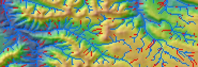
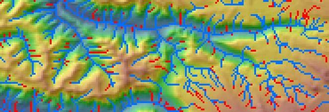
7 DEM, Flooding, and Slopes Original DEM Slope 128 x 187 = 23,936 pixels 216 (0.9%) pixels are modified by flooding Mean flood < 1 meter Maximum flood 30 meters DEM modified by flooding

 Stream")
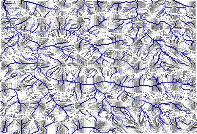
8 Drainage directions (D8) Drainage direction is calculated for every pixel D8 network defines individual drainage basins D8 network is not a drainage network Drainage network is a subset of D8 network Individual basins (45) Stream order (1 to 7)


9 Drainage directions (D8) original DEM Even small DEM imperfections lead to large changes in D8 network Imperfections increase number of basins Drainage Imperfections lower the maximum stream order Individual basins (79) Stream order (1 to 5)


10 Delineating drainage network using contributing area A drainage (contributing) area Threshold = 10 pixels Q mean annual discharge Q ~ A


11 Delineating network using contributing area threshold Threshold = 10 pixels Threshold = 50 pixels


12 Delineating drainage network using stream order >= 3 rd order
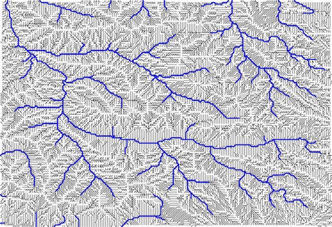

13 Delineating network using stream order threshold >= 3 rd order >= 4 th order


14 Delineating network using contributing area and slope a A S > C a = 2 C = 0.5 This algorithm provides a mechanism for spatially variable drainage density Montgomery and Dietrich, Science, 255, p826, 1992 It results in feathering of the drainage network in steeper areas, while omitting drainage networks in less steep valleys.


15 Trouble with Mars Evros Vallis West. site 31% modified by flood A>=500 pixels network
 Evros Vallis West.")

16 Trouble with Mars (imperfect solution) Evros Vallis West. site 18% modified by flood <=200 meters Valley mapped by our new method A>=500 pixels network

17 Terrain morphology-based valley mapping algorithm Steps 1 and 2 - digital terrain analysis methods Steps 3 and 4 - image processing methods Molloy and Stepinski, Computers & Geoscience, submitted, 2006

18 Step 1.2: Calculating tangential curvature Pollack test site Tangential curvature is measured in a direction of tangent to contour. Blue: positive curvature (convergent) Red: negative curvature (divergent)

19 Step 1.3: Thresholding curvature map Map of tangential curvature Only pixels with curvature > (1/m) are shown in blue
20 Image processing steps

21 Final product of our algorithm Map of VN derived using our algorithm Map of VN derived using our D8 Algorithm with A>=200 pixels threshold

22 Test sites


23 Automatic vs. manual mappings (visual comparison)


24 Automated vs. manual mappings (quantitative comparison) Manually mapped network Automatically delineated network
25 Conclusions about our algorithm D8 algorithm is not a good base for automatic mapping of drainage network. Different channelization criteria can be applied to D8 network to yield an actual drainage network, but they all lead to approximately constant drainage density, in contrast to what is seen on Mars. Our algorithm is not based on drainage directions. It maps valleys where they are seen. It produces maps that are in good agreement with manual mapping. Our maps are consistent and topographically correct in contrast to manually derived maps. Our algorithm is fast enough and precise enough to be employed in mapping of VN over large areas of Martian surface.

26 Application to the Mare Tyrrhenum quadrangle Luo and Stepinski, Geophysical Research Letters, 33, L18202, 2006

27 Drainage density in the Mare Tyrrhenum quadrangle

28 Continuous map of drainage density in the Mare Tyrrhenum quadrangle
29 Mare Tyrrhenum results An order of magnitude higher drainage density in Noachian terrain than the values inferred from a global map based on Viking images. Drainage density in Noachian terrain comparable to the values inferred from the precision manual mapping of selected focus sites. High dissection of all Noachian units. Variation in dissection of Noachian terrain on scales from 1000 km to 100 km. Lack of correlation between degree of dissection and terrain parameters. Omnipresence of dissection suggests precipitation.


30 Bonus: Terrestrial applications for our algorithm J. Taylor Perron PERMEABILITY, RECHARGE, AND RUNOFF GENERATION ON MARS Workshop on Mars Valley Networks Kohala Coast, Hawaii August 11-15, 2004


31 D8 algorithm fails in Oregon Cascades

32 Our algorithm succeeds in Oregon Cascades


33 Map of drainage network Bigger picture Map of drainage density Map of simplest geology tertiary quaternary
The History of Water on Mars: Synthesis of New Results from Valley Networks and Deltas
 The History of Water on Mars: Synthesis of New Results from Valley Networks and Deltas Brian M. Hynek Professor at the University of Colorado, Laboratory for Atmospheric and Space Physics Department of
Automated Identification and Characterization of Landforms on Mars
 Automated Identification and Characterization of Landforms on Mars Tomasz F. Stepinski Lunar and Planetary Institute Collaborators: Wei Luo Students: Brain Bue Ian Molloy Erik Urbach Michael Mendenhall
Drainage Density and Controlling Factors in Cascade Range, Oregon, USA
 Drainage Density and Controlling Factors in Cascade Range, Oregon, USA Wei Luo *a, Tomasz Stepinski b, and Yi Qi a a Department of Geography, Northern Illinois University, DeKalb, IL 60115, USA; b Lunar
Extraction of Martian valley networks from digital topography
 JOURNAL OF GEOPHYSICAL RESEARCH, VOL. 109,, doi:10.1029/2004je002269, 2004 Extraction of Martian valley networks from digital topography T. F. Stepinski Lunar and Planetary Institute, Houston, Texas, USA
Digital Elevation Models. Using elevation data in raster format in a GIS
 Digital Elevation Models Using elevation data in raster format in a GIS What is a Digital Elevation Model (DEM)? Digital representation of topography Model based on scale of original data Commonly a raster
Presentation given to computer science undergraduate students at the University of Houston July 2007
 Presentation given to computer science undergraduate students at the University of Houston July 2007 Machine Learning and Data Mining in Mars Tomasz F. Stepinski Lunar and Planetary Institute MARS/EARTH
HYDROLOGIC AND WATER RESOURCES EVALUATIONS FOR SG. LUI WATERSHED
 HYDROLOGIC AND WATER RESOURCES EVALUATIONS FOR SG. LUI WATERSHED 1.0 Introduction The Sg. Lui watershed is the upper part of Langat River Basin, in the state of Selangor which located approximately 20
SUPPLEMENTARY INFORMATION
 SUPPLEMENTARY INFORMATION Supplementary Materials for Ancient ocean on Mars supported by global distribution of deltas and valleys Gaetano Di Achille 1* & Brian M. Hynek 1,2 1 Laboratory for Atmospheric
THE NEW GEOLOGY OF MARS: TOP TEN RESULTS OF POST-VIKING GLOBAL MAPPING AND CRATER-DATING
 THE NEW GEOLOGY OF MARS: TOP TEN RESULTS OF POST-VIKING GLOBAL MAPPING AND CRATER-DATING K.L. Tanaka 1, J.A. Skinner, Jr. 1, C.M. Fortezzo 1, T.M. Hare 1, R.P. Irwin 2, T. Platz 3, G. Michael 3, J.M. Dohm
Roaming zones of precipitation on ancient Mars as recorded in valley networks
 JOURNAL OF GEOPHYSICAL RESEARCH, VOL. 114,, doi:10.1029/2008je003247, 2009 Roaming zones of precipitation on ancient Mars as recorded in valley networks Monica R. T. Hoke 1,2 and Brian M. Hynek 2,3 Received
UTILIZING LIDAR DATA FOR DETECTION OF CHANNEL MIGRATION TAYLOR VALLEY, ANTARCTICA ID: C34A-05
 Martin, M., Commonwealth Glacier, Dry Valleys, Digital Image, Oceanwide Expeditions UTILIZING LIDAR DATA FOR DETECTION OF CHANNEL MIGRATION TAYLOR VALLEY, ANTARCTICA ID: C34A-05 M. Camille Barlow, Jennifer
Elevations are in meters above mean sea level. Scale 1:2000
 12.001 LAB 7: TOPOGRAPHIC MAPS Due: Monday, April 11 PART I: CONTOURING AND PROFILES (20 PTS) 1. Contour this area map using a 5 meter contour interval. Remember some fundamental rules of contour lines,
Chapter 6 Mapping and Online Tools
 Chapter 6 Mapping and Online Tools The stream site you monitor is just part of a much larger system. When analyzing stream health, it is important to take a holistic view by considering the entire watershed.
Oregon Water Conditions Report May 1, 2017
 Oregon Water Conditions Report May 1, 2017 Mountain snowpack in the higher elevations has continued to increase over the last two weeks. Statewide, most low and mid elevation snow has melted so the basin
Cross-sectional and longitudinal profiles of valleys and channels in Xanthe Terra on Mars
 JOURNAL OF GEOPHYSICAL RESEARCH, VOL. 110,, doi:10.1029/2005je002454, 2005 Cross-sectional and longitudinal profiles of valleys and channels in Xanthe Terra on Mars A. Kereszturi Institute for Advanced
International Journal of Advance Engineering and Research Development
 Scientific Journal of Impact Factor (SJIF): 4.72 International Journal of Advance Engineering and Research Development Volume 4, Issue 5, May -2017 Watershed Delineation of Purna River using Geographical
Did Fluvial Landforms Form Under A Warmer Early Mars?
 Did Fluvial Landforms Form Under A Warmer Early Mars? N. Mangold, LPG Nantes/CNRS, France Acknowledgments: I warmly thank all colleagues and students having worked with me in the last 15 years. Textbook
California 120 Day Precipitation Outlook Issued Tom Dunklee Global Climate Center
 California 120 Day Precipitation Outlook Issued 11-01-2008 Tom Dunklee Global Climate Center This is my second updated outlook for precipitation patterns and amounts for the next 4 s of the current rainy
PROANA A USEFUL SOFTWARE FOR TERRAIN ANALYSIS AND GEOENVIRONMENTAL APPLICATIONS STUDY CASE ON THE GEODYNAMIC EVOLUTION OF ARGOLIS PENINSULA, GREECE.
 PROANA A USEFUL SOFTWARE FOR TERRAIN ANALYSIS AND GEOENVIRONMENTAL APPLICATIONS STUDY CASE ON THE GEODYNAMIC EVOLUTION OF ARGOLIS PENINSULA, GREECE. Spyridoula Vassilopoulou * Institute of Cartography
General Overview and Facts about the Irobland
 Using Geoinformation Science to Reveal the Impact of the Eritrea-Ethiopia Boundary Commission s Decision on Irobland and People By Alema Tesfaye, Washington DC, USA Part I General Overview and Facts about
Characterization of Catchments Extracted From. Multiscale Digital Elevation Models
 Applied Mathematical Sciences, Vol. 1, 2007, no. 20, 963-974 Characterization of Catchments Extracted From Multiscale Digital Elevation Models S. Dinesh Science and Technology Research Institute for Defence
GIS feature extraction tools in diverse landscapes
 CE 394K.3 GIS in Water Resources GIS feature extraction tools in diverse landscapes Final Project Anna G. Kladzyk M.S. Candidate, Expected 2015 Department of Environmental and Water Resources Engineering
Influence of Terrain on Scaling Laws for River Networks
 Utah State University DigitalCommons@USU All Physics Faculty Publications Physics 11-1-2002 Influence of Terrain on Scaling Laws for River Networks D. A. Vasquez D. H. Smith Boyd F. Edwards Utah State
Generation and analysis of Digital Elevation Model (DEM) using Worldview-2 stereo-pair images of Gurgaon district: A geospatial approach
 using Worldview-2 stereo-pair images of Gurgaon district: A geospatial approach") 186 Generation and analysis of Digital Elevation Model (DEM) using Worldview-2 stereo-pair images of Gurgaon district: A geospatial approach Arsad Khan 1, Sultan Singh 2 and Kaptan Singh 2 1 Department
186 Generation and analysis of Digital Elevation Model (DEM) using Worldview-2 stereo-pair images of Gurgaon district: A geospatial approach Arsad Khan 1, Sultan Singh 2 and Kaptan Singh 2 1 Department
A new model for evaluating the duration of water ow in the Martian uvial systems
 Mem. S.A.It. Vol. 87, 40 c SAIt 2016 Memorie della A new model for evaluating the duration of water ow in the Martian uvial systems G. Alemanno 1, V. Orofino 1, G. Di Achille 2, and F. Mancarella 1 1 Dipartimento
Sediment dynamics and sub-recent sediment budget of the braided sandur system at Sandane, Erdalen (Nordfjord, western Norway)
") Sediment dynamics and sub-recent sediment budget of the braided sandur system at Sandane, Erdalen (Nordfjord, western Norway) A.A. Beylich (1,2), L. Hansen (1), S. Liermann (3), D. Gintz (3), K. Laute
Sediment dynamics and sub-recent sediment budget of the braided sandur system at Sandane, Erdalen (Nordfjord, western Norway) A.A. Beylich (1,2), L. Hansen (1), S. Liermann (3), D. Gintz (3), K. Laute
STATISTICAL MODELING OF LANDSLIDE HAZARD USING GIS
 STATISTICAL MODELING OF LANDSLIDE HAZARD USING GIS By Peter V. Gorsevski, Department of Forest Resources College of Natural Resources University of Idaho; Randy B. Foltz, U.S. Forest Service, Rocky Mountain
EFFICIENCY OF THE INTEGRATED RESERVOIR OPERATION FOR FLOOD CONTROL IN THE UPPER TONE RIVER OF JAPAN CONSIDERING SPATIAL DISTRIBUTION OF RAINFALL
 EFFICIENCY OF THE INTEGRATED RESERVOIR OPERATION FOR FLOOD CONTROL IN THE UPPER TONE RIVER OF JAPAN CONSIDERING SPATIAL DISTRIBUTION OF RAINFALL Dawen YANG, Eik Chay LOW and Toshio KOIKE Department of
Drainage Basin Geomorphology. Nick Odoni s Slope Profile Model
 Drainage Basin Geomorphology Nick Odoni s Slope Profile Model Odoni s Slope Profile Model This model is based on solving the mass balance (sediment budget) equation for a hillslope profile This is achieved
MOUNTAIN ORDERING: A METHOD FOR CLASSIFYING MOUNTAINS BASED ON THEIR MORPHOMETRY
 Earth Surface Processes and Landforms Earth Surf. Process. Landforms 24, 653±660 (1999) MOUNTAIN ORDERING: A METHOD FOR CLASSIFYING MOUNTAINS BASED ON THEIR MORPHOMETRY SHUJI YAMADA Department of Geography,
COSMORPHOLOGY - May 2009
 Name COSMORPHOLOGY - May 2009 Geologic landforms Purpose: By studying aerial photographs you will learn to identify different kinds of geologic features based on their different morphologies and learn
Oxia Planum. ExoMars. Ellipse ~ 104 km x 19 km Between 25 N & 5 S < -2 km elevation
 ExoMars Oxia Planum Ellipse ~ 104 km x 19 km Between 25 N & 5 S < -2 km elevation Astrobiological mission Outflow for Coogoon Valles Phyllosilicates Igneous units Mars 2020 Next MSL-class rover Landing
Professional Appointments Visiting Professor (Fall 2014-Spring 2015), Kansas State University, Department of Geography
, Kansas State University, Department of Geography") Dr. Bartosz P. Grudzinski Department of Geography, Kansas State University 118 Seaton Hall, Manhattan, KS 66506 Phone: (773) 308-3353 Email: Bpgrudzinski@gmail.com Education Ph.D., Geography, Kansas State
Dr. Bartosz P. Grudzinski Department of Geography, Kansas State University 118 Seaton Hall, Manhattan, KS 66506 Phone: (773) 308-3353 Email: Bpgrudzinski@gmail.com Education Ph.D., Geography, Kansas State
APPLIED FLUVIAL GEOMORPHOLOGY
 APPLIED FLUVIAL GEOMORPHOLOGY Where have we come from, where do we go? Roger TJ Phillips Mariëtte Pushkar and Peter Ashmore Value of Geomorphologists in River Management Start with Historical Geology and
Year 6. Geography. Revision
 Year 6 Geography Revision November 2017 Rivers and World knowledge How the water cycle works and the meaning of the terms evaporation, condensation, precipitation, transpiration, surface run-off, groundwater
Climatic Change Implications for Hydrologic Systems in the Sierra Nevada
 Climatic Change Implications for Hydrologic Systems in the Sierra Nevada Part Two: The HSPF Model: Basis For Watershed Yield Calculator Part two presents an an overview of why the hydrologic yield calculator
AN ABSTRACT OF THE DISSERTATION OF. Tracy Arras for the degree of Doctor of Philosophy in Water Resources Engineering presented on March 27, 2014.
 AN ABSTRACT OF THE DISSERTATION OF Tracy Arras for the degree of Doctor of Philosophy in Water Resources Engineering presented on March 27, 2014. Title: A GIS Approach to Estimating Continuous Hydraulic
INTERNATIONAL JOURNAL OF GEOMATICS AND GEOSCIENCES Volume 2, No 1, 2011
 INTERNATIONAL JOURNAL OF GEOMATICS AND GEOSCIENCES Volume 2, No 1, 2011 Copyright 2010 All rights reserved Integrated Publishing services Research article ISSN 0976 4380 Hypsometric Analysis of Varattaru
Martian geomorphology from fractal analysis of drainage networks
 JOURNAL OF GEOPHYSICAL RESEARCH, VOL. 109,, doi:10.1029/2003je002098, 2004 Martian geomorphology from fractal analysis of drainage networks T. F. Stepinski Lunar and Planetary Institute, Houston, Texas,
Delineation of Groundwater Potential Zone on Brantas Groundwater Basin
 Delineation of Groundwater Potential Zone on Brantas Groundwater Basin Andi Rachman Putra 1, Ali Masduqi 2 1,2 Departement of Environmental Engineering, Sepuluh Nopember Institute of Technology, Indonesia
The Effect of Resolution on Scaling Relations and Concavity on Valley Networks on Mars
 The Effect of Resolution on Scaling Relations and Concavity on Valley Networks on Mars Peter G. Smith Department of Resource Analysis, Saint Mary s University of Minnesota, Winona, MN 55987 Keywords: GIS,
Fluvial sedimentary deposits on Mars: Ancient deltas in a crater lake in the Nili Fossae region
 GEOPHYSICAL RESEARCH LETTERS, VOL. 32, L14201, doi:10.1029/2005gl023456, 2005 Fluvial sedimentary deposits on Mars: Ancient deltas in a crater lake in the Nili Fossae region Caleb I. Fassett and James
Watershed concepts for community environmental planning
 Purpose and Objectives Watershed concepts for community environmental planning Dale Bruns, Wilkes University USDA Rural GIS Consortium May 2007 Provide background on basic concepts in watershed, stream,
Dr. Bartosz P. Grudzinski Education Ph.D., Geography M.S., Geography B.S., Geography Professional Appointments Assistant Professor
 Dr. Bartosz P. Grudzinski Department of Geography, 218 Shideler Hall, Oxford, OH 45056 Phone: (773) 308-3353 Email: grudzibp@miamioh.edu Education Ph.D., Geography, Kansas State University, 2010-2014 Dissertation:
INTERNATIONAL JOURNAL OF GEOMATICS AND GEOSCIENCES Volume 1, No 4, 2011
 Detection of seafloor channels using Bathymetry data in Geographical Information Systems Kundu.S.N, Pattnaik.D.S Department of Geology, Utkal University, Vanivihar, Bhubaneswar. Orissa. snkundu@gmail.com
Landslide Computer Modeling Potential
 Landslide Computer Modeling Potential Michael D. Dixon, P.E. Civil Engineer Payette National Forest The Payette National Forest selected the Stability Index Mapping (SINMAP) model for use in identifying
Watershed modeling in the Tyrrhena Terra region of Mars
 JOURNAL OF GEOPHYSICAL RESEARCH, VOL. 115,, doi:10.1029/2009je003429, 2010 Watershed modeling in the Tyrrhena Terra region of Mars Scott C. Mest, 1,2 David A. Crown, 1 and William Harbert 3 Received 9
Using Remote Sensing to Analyze River Geomorphology
 Using Remote Sensing to Analyze River Geomorphology Seeing Water from Space Workshop August 11 th, 2015 George Allen geoallen@unc.edu Rivers impact: Geology Ecology Humans The atmosphere River Geomorphology
MODULE 7 LECTURE NOTES 5 DRAINAGE PATTERN AND CATCHMENT AREA DELINEATION
 MODULE 7 LECTURE NOTES 5 DRAINAGE PATTERN AND CATCHMENT AREA DELINEATION 1. Introduction Topography of the river basin plays an important role in hydrologic modelling, by providing information on different
Which map shows the stream drainage pattern that most likely formed on the surface of this volcano? A) B)
 B)") 1. When snow cover on the land melts, the water will most likely become surface runoff if the land surface is A) frozen B) porous C) grass covered D) unconsolidated gravel Base your answers to questions
1. When snow cover on the land melts, the water will most likely become surface runoff if the land surface is A) frozen B) porous C) grass covered D) unconsolidated gravel Base your answers to questions
ENGRG Introduction to GIS
 ENGRG 59910 Introduction to GIS Michael Piasecki March 17, 2014 Lecture 08: Terrain Analysis Outline: Terrain Analysis Earth Surface Representation Contour TIN Mass Points Digital Elevation Models Slope
Automatic Change Detection from Remote Sensing Stereo Image for Large Surface Coal Mining Area
 doi: 10.14355/fiee.2016.05.003 Automatic Change Detection from Remote Sensing Stereo Image for Large Surface Coal Mining Area Feifei Zhao 1, Nisha Bao 2, Baoying Ye 3, Sizhuo Wang 4, Xiaocui Liu 5, Jianyan
Lidar data in water resources applications. Paola Passalacqua CE 374K Lecture, April 5 th, 2012
 Lidar data in water resources applications Paola Passalacqua CE 374K Lecture, April 5 th, 2012 Airborne Lidar Airborne laser altimetry technology (LiDAR, Light Detection And Ranging) provides high-resolution
Creating Watersheds and Stream Networks. Steve Kopp
 Creating Watersheds and Stream Networks Steve Kopp Workshop Overview Demo Data Understanding the tools Elevation Data Types DEM : Digital Elevation Model bare Earth DSM : Digital Surface Model Data Structure
Hydraulic conductivity of the High Plains Aquifer re-evaluated using surface drainage patterns
 GEOPHYSICAL RESEARCH LETTERS, VOL. 39,, doi:10.1029/2011gl050200, 2012 Hydraulic conductivity of the High Plains Aquifer re-evaluated using surface drainage patterns Wei Luo 1 and Darryll T. Pederson 2
Basin-scale analysis of long-term sediment-generation rates derived from 10 Be in river sediment:
 Basin-scale analysis of long-term sediment-generation rates derived from 10 Be in river sediment: The Susquehanna River basin and beyond Joanna M. Reuter M.S. Proposal April 30, 2003 Paul Bierman, advisor
ENGRG Introduction to GIS
 ENGRG 59910 Introduction to GIS Michael Piasecki November 17, 2017 Lecture 11: Terrain Analysis Outline: Terrain Analysis Earth Surface Representation Contour TIN Mass Points Digital Elevation Models Slope
Basin characteristics
 Basin characteristics From hydrological processes at the point scale to hydrological processes throughout the space continuum: point scale à river basin The watershed characteristics (shape, length, topography,
Oregon Water Conditions Report April 17, 2017
 Oregon Water Conditions Report April 17, 2017 Mountain snowpack continues to maintain significant levels for mid-april. By late March, statewide snowpack had declined to 118 percent of normal after starting
GIS Techniques for Floodplain Delineation. Dean Djokic
 GIS Techniques for Floodplain Delineation Dean Djokic (ddjokic@esri.com) Content What is a floodplain? How to get a floodplain? What can GIS do for floodplain modeling? Simple GIS techniques for floodplain
Welcome to NetMap Portal Tutorial
 Welcome to NetMap Portal Tutorial Potential Applications What Can you do with the Portal? At least 25 things! 1) Locate the best potential fish habitats. 2) Identify biological hotspots. 3) Map floodplain
CE 394K.3 GIS in Water Resources Midterm Quiz Fall There are 5 questions on this exam. Please do all 5. They are of equal credit.
 Name: CE 394K.3 GIS in Water Resources Midterm Quiz Fall 2000 There are 5 questions on this exam. Please do all 5. They are of equal credit. 1. The ArcView Geographic Information System can display different
Evaluation of gvsig and SEXTANTE Tools for Hydrological Analysis Schröder Dietrich a, Mudogah Hildah b and Franz David b
 Evaluation of gvsig and SEXTANTE Tools for Hydrological Analysis Schröder Dietrich a, Mudogah Hildah b and Franz David b ab Photogrammetry and Geo-informatics Masters Programme, Stuttgart University of
Laboratory Exercise #4 Geologic Surface Processes in Dry Lands
 Page - 1 Laboratory Exercise #4 Geologic Surface Processes in Dry Lands Section A Overview of Lands with Dry Climates The definition of a dry climate is tied to an understanding of the hydrologic cycle
Hydrologically Consistent Pruning of the High- Resolution National Hydrography Dataset to 1:24,000-scale
 Hydrologically Consistent Pruning of the High- Resolution National Hydrography Dataset to 1:24,000-scale Lawrence V. Stanislawski 1, Ariel Doumbouya 2, Barbara P. Buttenfield 3, 1 Center for Excellence
A real-time flood forecasting system based on GIS and DEM
 Remote Sensing and Hydrology 2000 (Proceedings of a symposium held at Santa Fe, New Mexico, USA, April 2000). IAHS Publ. no. 267, 2001. 439 A real-time flood forecasting system based on GIS and DEM SANDRA
Hypsometric analysis of Margaritifer Sinus and origin of valley networks
 JOURNAL OF GEOPHYSICAL RESEARCH, VOL. 107, NO. E10, 5071, doi:10.1029/2001je001500, 2002 Hypsometric analysis of Margaritifer Sinus and origin of valley networks Wei Luo Department of Geography, Northern
Geomorphology Of The Chilliwack River Watershed Landform Mapping At North Cascades National Park Service Complex, Washington By National Park Service
 Geomorphology Of The Chilliwack River Watershed Landform Mapping At North Cascades National Park Service Complex, Washington By National Park Service READ ONLINE Snowshed contributions to the Nooksack
THE FLUVIAL ACTION OF THE KARLA BASIN STREAMS IN A NATURAL AND MAN MADE ENVIRONMENT
 Δελτίο της Ελληνικής Γεωλογικής Εταιρίας, 2010 Bulletin of the Geological Society of Greece, 2010 Πρακτικά 12ου Διεθνούς Συνεδρίου Proceedings of the 12th International Congress Πάτρα, Μάιος 2010 Patras,
Morphometric Analysis of Chamundi Hills, Mysuru, India Using Geographical Information System
 Volume-7, Issue-1, January-February 2017 International Journal of Engineering and Management Research Page Number: 279-283 Morphometric Analysis of s, Mysuru, India Using Geographical Information System
Iron and Titanium: Important Elements. posted October 20, References:
 1 of 6 posted October 20, 1997 Moonbeams and Elements Written by G. Jeffrey Taylor Hawai'i Institute of Geophysics and Planetology To determine how a planetary body formed and evolved, we must determine
Lecture 3. Data Sources for GIS in Water Resources
 Lecture 3 Data Sources for GIS in Water Resources GIS in Water Resources Spring 2015 http://www.data.gov/ 1 USGS GIS data for Water http://water.usgs.gov/maps.html Watersheds of the US 2-digit water resource
The Latest from Mars: Recent Results and the Next Decade of Exploration
 The Latest from Mars: Recent Results and the Next Decade of Exploration Brian M. Hynek Laboratory for Atmospheric and Space Physics & Department of Geological Sciences, University of Colorado Mars ½ diameter
Impact of DEM Resolution on Topographic Indices and Hydrological Modelling Results
 Impact of DEM Resolution on Topographic Indices and Hydrological Modelling Results J. Vaze 1, 2 and J. Teng 1, 2 1 Department of Water and Energy, NSW, Australia 2 ewater Cooperative Research Centre, Australia
GeoWEPP Tutorial Appendix
 GeoWEPP Tutorial Appendix Chris S. Renschler University at Buffalo - The State University of New York Department of Geography, 116 Wilkeson Quad Buffalo, New York 14261, USA Prepared for use at the WEPP/GeoWEPP
Lidar data in water resources applications
 Lidar data in water resources applications Paola Passalacqua CE 394K 3 Guest Lecture, November 15 th, 2012 Airborne Lidar Airborne laser altimetry technology (lidar, Light Detection And Ranging) provides
LAVA FLOWS IN THE THARSIS REGION OF MARS: ESTIMATES OF FLOW SPEEDS AND VOLUME FLUXES
 LAVA FLOWS IN THE THARSIS REGION OF MARS: ESTIMATES OF FLOW SPEEDS AND VOLUME FLUXES Carolyn Parcheta Department of Geology and Geophysics University of Hawai i at Manoa Honolulu, HI 96822 ABSTRACT The
Chapter 1 Quantitative Analysis of Geomorphometric Parameters of Wadi Kerak, Jordan, Using Remote Sensing and GIS
 Chapter 1 Quantitative Analysis of Geomorphometric Parameters of Wadi Kerak, Jordan, Using Remote Sensing and GIS Yahya Farhan, Ali Anbar, Omar Enaba, Nisrin Al-Shaikh Geomorphometric analysis was carried
ESTIMATING SNOWMELT CONTRIBUTION FROM THE GANGOTRI GLACIER CATCHMENT INTO THE BHAGIRATHI RIVER, INDIA ABSTRACT INTRODUCTION
 ESTIMATING SNOWMELT CONTRIBUTION FROM THE GANGOTRI GLACIER CATCHMENT INTO THE BHAGIRATHI RIVER, INDIA Rodney M. Chai 1, Leigh A. Stearns 2, C. J. van der Veen 1 ABSTRACT The Bhagirathi River emerges from
MAPPING POTENTIAL LAND DEGRADATION IN BHUTAN
 MAPPING POTENTIAL LAND DEGRADATION IN BHUTAN Moe Myint, Geoinformatics Consultant Rue du Midi-8, CH-1196, Gland, Switzerland moemyint@bluewin.ch Pema Thinley, GIS Analyst Renewable Natural Resources Research
Table 1 PRISM/OB1 data summary in this study. PI400-2 Table 2 PRISM/OB1 data summary in this study. 2'#7-#/ :> 8>?= B-/"# 899:;98;<= :> 8A89
 PI400-1 EVALUATION ANALYSIS FOR DIGITAL TERRAIN MODELS GENERATED FROM ALOS/PRISM -OB2 DATA PI No. 400 Tomohito Asaka (PI) 1, Yoshiyuki Yamamoto (CI) 2 1 Nihon University, Izumi 1-2-1, Narashino Chiba,
GROUND SURFACE VISUALIZATION USING RED RELIEF IMAGE MAP FOR A VARIETY OF MAP SCALES
 GROUND SURFACE VISUALIZATION USING RED RELIEF IMAGE MAP FOR A VARIETY OF MAP SCALES T. Chiba a, B. Hasi a * a Asia Air Survey Co., Ltd., Kawasaki, Japan (has.baator, ta.chiba,)@ajiko.co.jp Commission II,
Vol.3,No.3,September2017
 Vol.3,No.3,September2017 Int. J. of Geol. & Earth Sci., 2017 Abiodun O Adebola et al., 2017 Research Paper ISSN 2395-647X www.ijges.com Vol. 3, No. 3, September 2017 2017 IJGES. All Rights Reserved MORPHOMETRIC
VILLAGE INFORMATION SYSTEM (V.I.S) FOR WATERSHED MANAGEMENT IN THE NORTH AHMADNAGAR DISTRICT, MAHARASHTRA
 FOR WATERSHED MANAGEMENT IN THE NORTH AHMADNAGAR DISTRICT, MAHARASHTRA") VILLAGE INFORMATION SYSTEM (V.I.S) FOR WATERSHED MANAGEMENT IN THE NORTH AHMADNAGAR DISTRICT, MAHARASHTRA Abstract: The drought prone zone in the Western Maharashtra is not in position to achieve the agricultural
VILLAGE INFORMATION SYSTEM (V.I.S) FOR WATERSHED MANAGEMENT IN THE NORTH AHMADNAGAR DISTRICT, MAHARASHTRA Abstract: The drought prone zone in the Western Maharashtra is not in position to achieve the agricultural
Governing Rules of Water Movement
 Governing Rules of Water Movement Like all physical processes, the flow of water always occurs across some form of energy gradient from high to low e.g., a topographic (slope) gradient from high to low
Using Earthscope and B4 LiDAR data to analyze Southern California s active faults
 Using Earthscope and B4 LiDAR data to analyze Southern California s active faults Exercise 8: Simple landscape morphometry and stream network delineation Introduction This exercise covers sample activities
Characterisation of valleys from DEMs
 18 th World IMACS / MODSIM Congress, Cairns, Australia 13-17 July 2009 http://mssanz.org.au/modsim09 Characterisation of valleys from DEMs Wang, D. 1,2 and Laffan, S.W. 1 1. School of Biological, Earth
Extreme Phenomena in Dobrogea - Floods and Droughts
 Extreme Phenomena in Dobrogea - Floods and Droughts PhD eng. Carmen Maftei Ovidius University of Constanta (Partner no 4) OUTLINES Introduction Study area Drought Floods Conclusion What is the problem?
CHAPTER EXIT CHAPTER. Models of Earth. 3.1 Modeling the Planet. 3.2 Mapmaking and Technology. 3.3 Topographic Maps CHAPTER OUTLINE
 EXIT CHAPTER.1 Modeling the Planet.2 Mapmaking and Technology. Topographic Maps CHAPTER OUTLINE CHAPTER.1 Modeling the Planet A flat of Earth is a convenient tool, but it can distort the shape, distance,
Dealing with Zone A Flood Zones. Topics of Discussion. What is a Zone A Floodplain?
 Dealing with Zone A Flood Zones Topics of Discussion Overview of Zone A Floodplains Permitting Development in Zone A Floodplains Estimating Flood Elevations in Zone A Flood Insurance Implications Letters
The Climate of Oregon Climate Zone 4 Northern Cascades
 /05 E55 Unbound issue No. 9/ is Does not circulate Special Report 916 May 1993 The Climate of Oregon Climate Zone 4 Property of OREGON STATE UNIVERSITY Library Serials Corvallis, OR 97331-4503 Agricultural
Web-based Interactive Landform Simulation Model (WILSIM)
") Web-based Interactive Landform Simulation Model (WILSIM) Wei Luo Dept. of Geography Northern Illinois University, DeKalb, IL 60115 Project Funded by NSF CCLI (2002-2004) Collaborators: Kirk Duffin, Jay
Web-based Interactive Landform Simulation Model (WILSIM) Wei Luo Dept. of Geography Northern Illinois University, DeKalb, IL 60115 Project Funded by NSF CCLI (2002-2004) Collaborators: Kirk Duffin, Jay
39 Mars Ice: Intermediate and Distant Past. James W. Head Brown University Providence, RI
 39 Mars Ice: Intermediate and Distant Past James W. Head Brown University Providence, RI james_head@brown.edu 37 Follow the Water on Mars: 1. Introduction: Current Environments and the Traditional View
Extracting Drainage Network from High Resolution DEM. in Toowoomba, Queensland
 Extracting Drainage Network from High Resolution DEM in Toowoomba, Queensland Xiaoye Liu and Zhenyu Zhang Keywords: digital elevation model, drainage network, stream order, Toowoomba, Condamine catchment,
Pixel-based and object-based landslide mapping: a methodological comparison
 Pixel-based and object-based landslide mapping: a methodological comparison Daniel HÖLBLING 1, Tsai-Tsung TSAI 2, Clemens EISANK 1, Barbara FRIEDL 1, Chjeng-Lun SHIEH 2, and Thomas BLASCHKE 1 1 Department
Long-term precipitation and late-stage valley network formation: Landform simulations of Parana Basin, Mars
 Long-term precipitation and late-stage valley network formation: Landform simulations of Parana Basin, Mars Charles J. Barnhart Department of Earth and Planetary Sciences University of California, Santa
Geology 101 Lab Worksheet: Topographic Maps
 Geology 101 Lab Worksheet: Topographic Maps Name: Refer to the Topographic Maps Lab for the information you need to complete this worksheet (http://commons.wvc.edu/rdawes/g101ocl/labs/topomapslab.html).
LAB 5: LANDSLIDE RECOGNITION AND MAPPING
 Geology 350 1 LAB 5: LANDSLIDE RECOGNITION AND MAPPING OBJECTIVES: a. to learn to recognize and classify landslides on airphotos and topographic maps b. to learn to recognize landslide topography on topographic
Steve Pye LA /22/16 Final Report: Determining regional locations of reference sites based on slope and soil type. Client: Sonoma Land Trust
 Steve Pye LA 221 04/22/16 Final Report: Determining regional locations of reference sites based on slope and soil type. Client: Sonoma Land Trust Deliverables: Results and working model that determine
THE GLOBE DEM PARAMETERIZATION OF THE MOUNTAIN FEATURES OF MINOR ASIA INTRODUCTION AND AIM
 THE GLOBE DEM PARAMETERIZATION OF THE MOUNTAIN FEATURES OF MINOR ASIA George Ch. Miliaresis Department of Topography Technological Educational Institute of Athens 38 Tripoleos Str. Athens, 104-42, Greece