Using High-Resolution Commercial Imagery in the Geosciences
|
|
|
- Branden Sherman
- 6 years ago
- Views:
Transcription


1 Using High-Resolution Commercial Imagery in the Geosciences George Roth Geospatial Support Specialist 2015 AGU Student & Early Career Scientist Conference San Francisco, CA December 13th, 2015
2 The Geoscience Data Firehose Dramatic increase in the amount of data from sensor networks, satellites, and other platforms Geoscience groups are hiring more: Programmers / data scientists IT workers GIS analysts Web developers
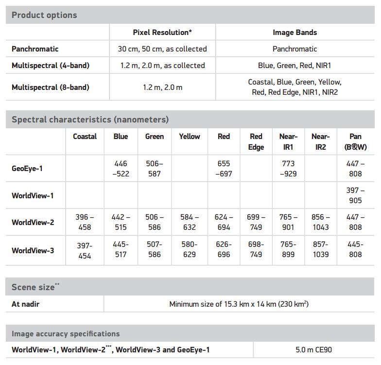
3 High-Resolution Imagery Part of the new generation of remote sensing tools available to a growing science user base Important tradeoffs: resolution vs. extent, repeat frequency, and band range Proprietary Bad news: Legally restricted, costs $, difficult to publish, republish, and to have others reproduce your results Good news: Users can request specific acquisition places/times, can often replace expensive aerial surveys, resolution benefits science logistics (thus benefiting science)
4 What can these satellites do?
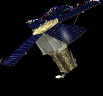

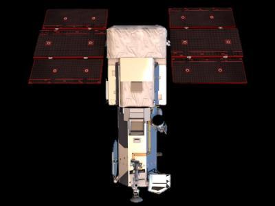
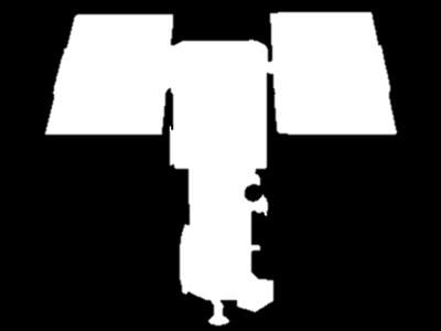
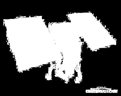
5 The DigitalGlobe Satellite Constellation IKONOS QuickBird GeoEye WorldView-2 WorldView-3 WorldView-1
6 DigitalGlobe Satellite Constellation Figure from DigitalGlobe, Inc.; images from Apollo Mapping

7 College Station, Texas. 250-meter MODIS Terra. ½ mile Imagery from NASA (10/11/2015)
")
8 College Station, Texas. 15-meter Landsat 8. ½ mile Imagery from USGS/NASA (7/29/2015)

9 College Station, Texas. 50-cm GeoEye-1. ½ mile Imagery DigitalGlobe, Inc. (6/23/2015)

10 32cm WorldView-3 image: Copyright 2015 DigitalGlobe
11

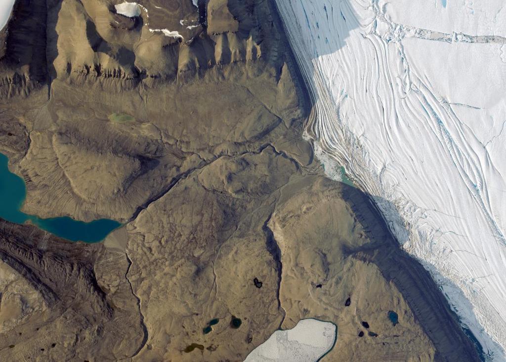
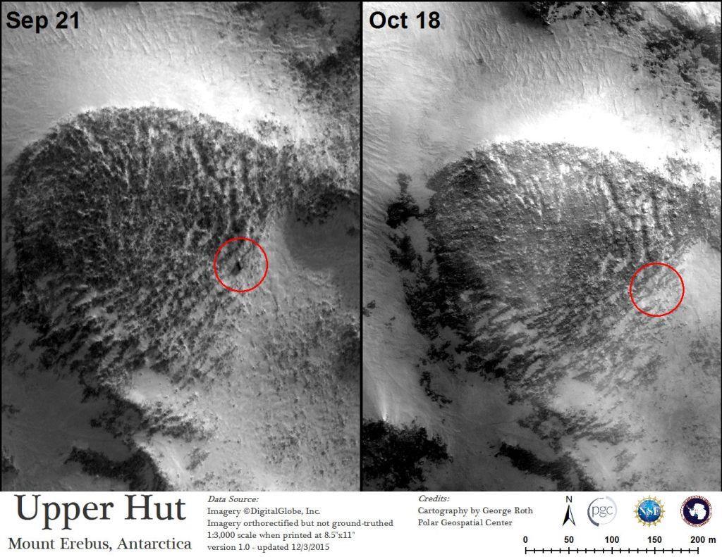
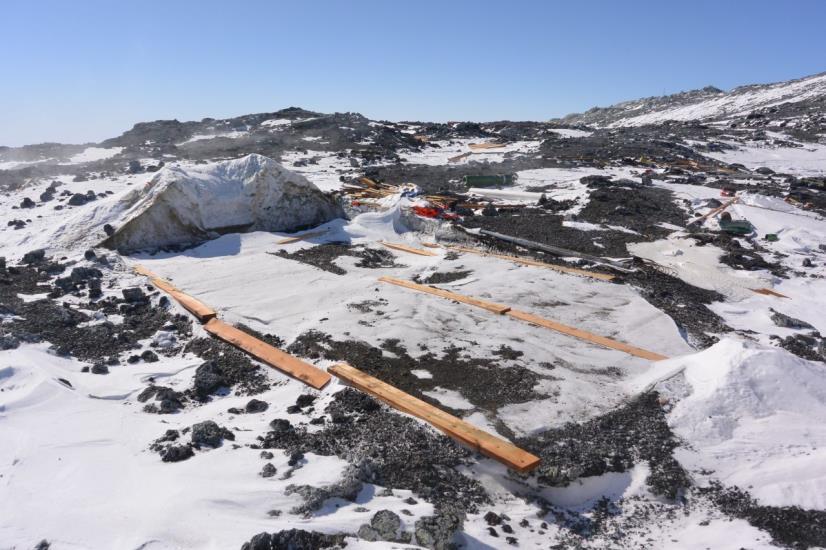
12 Bull Pass Camp, McMurdo Dry Valleys, Antarctica. imagery 2009 DigitalGlobe, Inc.


13 Bull Pass Camp, McMurdo Dry Valleys, Antarctica. imagery 2009 DigitalGlobe, Inc.
14 Geoscience Examples Proven applications of high-res imagery from PGC users Visual analysis and derived products


15 Examples: Petermann Glacier Integrated science support Marine science Ice drilling Boulder sampling Paleo- deltas Imagery DigitalGlobe, Inc.
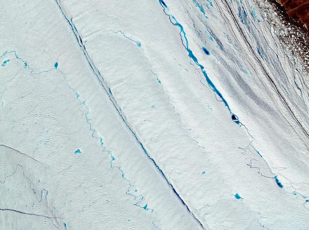
16 Imagery DigitalGlobe, Inc.

17 1km Imagery DigitalGlobe, Inc.
18 Imagery DigitalGlobe, Inc.

19 Imagery DigitalGlobe, Inc.


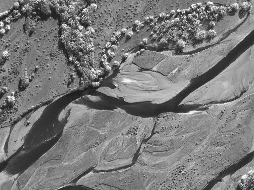
20 Examples: Alaska Coastline Automated coastal mapping Imagery DigitalGlobe, Inc.

21 Examples: Alaska Coastline Automated coastal mapping EP23A-0939: Automated Generation of the Alaska Coastline Using High-Resolution Satellite Imagery Tuesday, 15 December :40-18:00 Moscone South - Poster Hall

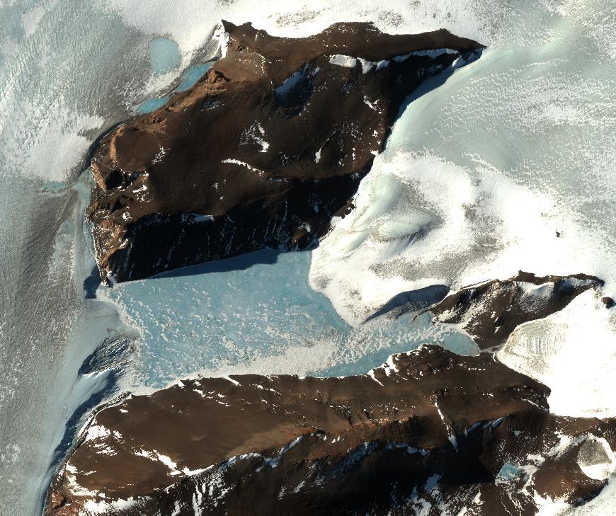
22 Edward VII Peninsula Penguin Colony, Antarctica. Imagery DigitalGlobe, Inc.

23 Examples: SpecMap Geologic Mapping from Space RSV parameters are designed to highlight compositional diversity using limited data. Combined into the same red, green, blue color combination: Red: A measure of the strength of the 1000 nm absorption feature, which is due to octahedrally coordinated Fe 2+ in mafic minerals (e.g., pyroxene, olivine) Green: A measure of the inflection near 546 nm, due to an Fe 3+ charge-transfer absorption and commonly dominates stained sedimentary lithologies Blue: An inverse measure of the inflection near 478 nm, which is common in coarsegrained igneous and metamorphic lithologies Same RGB color combination allows for easy comparisons PA33C-2197: Linking Samples to Orbital Imagery: Cataloging the Spectral Signatures of the Transantarctic Mountains for Future Compositional Studies and Remote Ground Truthing Wednesday, 16 December :40-18:00 Moscone South - Poster Hall Salvatore, M. R., et al. "Characterization of spectral and geochemical variability within the Ferrar Dolerite of the McMurdo Dry Valleys, Antarctica: weathering, alteration, and magmatic processes." Antarctic Science: doi: /s
24 Thanksgiving Point, VIS

25 Thanksgiving Point, RSV Mafic units (dolerites?) Less oxidized Intruded Unit (granitic?)


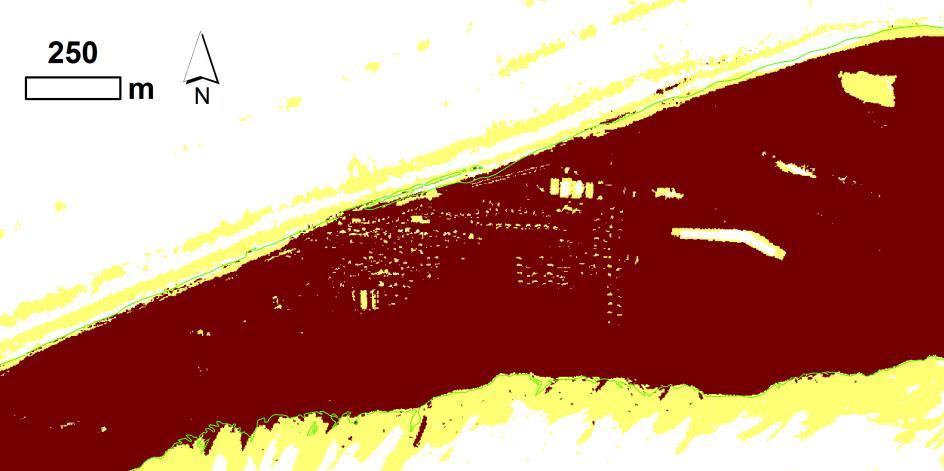
26 Mapping Photosynthetic Materials in Taylor Valley Biological hot spots can be identified by mapping the photosynthetic red edge across a landscape. Only possible using multispectral data with high spatial resolution. Repeat measurements can be used to track the migration and evolution of these ecosystems as the local hydrologic cycle changes. 500 m 500 m
27 How do I get this imagery? Level of access to imagery through PGC (pgc.umn.edu) depends on your funding source: NSF-PLR or NASA Cryosphere Other Academic: DigitalGlobe Foundation (grant application process)
28 Big shift in how science is done Remote Sensing is no longer limited to large scales, low resolutions Fieldwork is becoming increasingly optional...but more focused, productive, and efficient!
29 Data considerations Filesize Transfer Computing People!
30 Conclusion GIS/RS skills are becoming important, assumed, and even mandatory for early career geoscientists. As a geoscientist, tackle problems geospatially.
31 Thanks!
Route To A Remote Sensing Geology Career
 INFORMATION SYSTEMS LLC a U.S. company Route To A Remote Sensing Geology Career Today s Agenda: My Route Potential Employers & Skills Trends Going Forward Take-Away Messages GRSG - September 10, 2014 Cynthia
Physical Geography: Patterns, Processes, and Interactions, Grade 11, University/College Expectations
 Geographic Foundations: Space and Systems SSV.01 explain major theories of the origin and internal structure of the earth; Page 1 SSV.02 demonstrate an understanding of the principal features of the earth
Chapter 10: The Future of GIS Why Speculate? 10.2 Future Data 10.3 Future Hardware 10.4 Future Software 10.5 Some Future Issues and Problems
 Chapter 10: The Future of GIS 10.1 Why Speculate? 10.2 Future Data 10.3 Future Hardware 10.4 Future Software 10.5 Some Future Issues and Problems Theme of the Course GIS's place in understanding geographic
GEOG Lecture 8. Orbits, scale and trade-offs
 Environmental Remote Sensing GEOG 2021 Lecture 8 Orbits, scale and trade-offs Orbits revisit Orbits geostationary (36 000 km altitude) polar orbiting (200-1000 km altitude) Orbits revisit Orbits geostationary
Remote Sensing I: Basics
 Remote Sensing I: Basics Kelly M. Brunt Earth System Science Interdisciplinary Center, University of Maryland Cryospheric Science Laboratory, Goddard Space Flight Center kelly.m.brunt@nasa.gov (Based on
- satellite orbits. Further Reading: Chapter 04 of the text book. Outline. - satellite sensor measurements
 (1 of 12) Further Reading: Chapter 04 of the text book Outline - satellite orbits - satellite sensor measurements - remote sensing of land, atmosphere and oceans (2 of 12) Introduction Remote Sensing:
Geomorphologic Mapping by Airborne Laser Scanning in Southern Victoria Land
 Geomorphologic Mapping by Airborne Laser Scanning in Southern Victoria Land Bea Csatho, Terry Wilson, Tony Schenk, Garry McKenzie, Byrd Polar Research Center, The Ohio State University, Columbus, OH William
Home About Us Articles Press Releases Image Gallery Contact Us Media Kit Free Subscription 10/5/2006 5:56:35 PM
 Home About Us Articles Press Releases Image Gallery Contact Us Media Kit Free Subscription 10/5/2006 5:56:35 PM Industry Resources Industry Directory NASA Links Missions/Launches Calendar Human development
Name. 4. The diagram below shows a soil profile formed in an area of granite bedrock. Four different soil horizons, A, B, C, and D, are shown.
 Name 1. In the cross section of the hill shown below, which rock units are probably most resistant to weathering? 4. The diagram below shows a soil profile formed in an area of granite bedrock. Four different
Mapping Coastal Change Using LiDAR and Multispectral Imagery
 Mapping Coastal Change Using LiDAR and Multispectral Imagery Contributor: Patrick Collins, Technical Solutions Engineer Presented by TABLE OF CONTENTS Introduction... 1 Coastal Change... 1 Mapping Coastal
Remote Sensing and Spatial Analysis (RSSA)
") MESM Track Remote Sensing and Spatial Analysis (RSSA) Dr. Y.Q. Wang (Track Chair) http://nrs.uri.edu/people/faculty/wang.html Remote Sensing and Spatial Analysis Remote sensing, GIS, GPS and their applications
MESM Track Remote Sensing and Spatial Analysis (RSSA) Dr. Y.Q. Wang (Track Chair) http://nrs.uri.edu/people/faculty/wang.html Remote Sensing and Spatial Analysis Remote sensing, GIS, GPS and their applications
Fountain et al., 2017, The changing extent of the glaciers along the western Ross Sea, Antarctica: Geology, doi: /g
 GSA Data Repository 2017310 Fountain et al., 2017, The changing extent of the glaciers along the western Ross Sea, Antarctica: Geology, doi:10.1130/g39240.1. Supplementary Material Figure DR1. Assessing
Overview: Key Concepts: Time: 2, minute class periods. Materials:
 Text and Activities Adapted from: Teachers Domain, Texas A&M University: Ocean Drilling Distance Learning Program, The New York Times, Center for Remote Sensing of Ice Sheets (CReSIS), the Natural Resources
The Importance of Cultural Contexts in Climate Education
 The Importance of Cultural Contexts in Climate Education Kathryn Berry Bertram, Ph.D., University of Alaska Fairbanks Geophysical Institute Education Director Climate education for indigenous students
Pan-Arctic Digital Elevation Model - International Collaboration in Generation of ArcticDEM
 Pan-Arctic Digital Elevation Model - International Collaboration in Generation of ArcticDEM ESRI International Users Conference, June 30, 2016 Tracy Fuller, USGS Pan-Arctic DEM Technical Lead, Alaska Mapping
Lesson 4b Remote Sensing and geospatial analysis to integrate observations over larger scales
 Lesson 4b Remote Sensing and geospatial analysis to integrate observations over larger scales We have discussed static sensors, human-based (participatory) sensing, and mobile sensing Remote sensing: Satellite
1. Omit Human and Physical Geography electives (6 credits) 2. Add GEOG 677:Internet GIS (3 credits) 3. Add 3 credits to GEOG 797: Final Project
 2. Add GEOG 677:Internet GIS (3 credits) 3. Add 3 credits to GEOG 797: Final Project") The Department of Geography and the Office of Professional Studies propose to modify the Master of Professional Studies in Geospatial Information Sciences (GIS) as follows: 1. Omit Human and Physical Geography
The Department of Geography and the Office of Professional Studies propose to modify the Master of Professional Studies in Geospatial Information Sciences (GIS) as follows: 1. Omit Human and Physical Geography
Using Remote Sensing to Map the Evolution of Marsh Vegetation in the South Bay of San Francisco
 Using Remote Sensing to Map the Evolution of Marsh Vegetation in the South Bay of San Francisco Brian Fulfrost Design, Community and Environment (DC&E) 6 th Annual Bay-Delta Science Conference PROJECT
McIDAS Activities Within The NASA Langley Research Center Clouds And Radiation Group
 McIDAS Activities Within The NASA Langley Research Center Clouds And Radiation Group Kristopher Bedka Science Systems and Applications Inc @ NASA LaRC In Collaboration With (in alphabetical order) J. K.
Undergraduate Research Final Report: Estimation of suspended sediments using MODIS 250 m bands in Mayagüez Bay, Puerto Rico
 Undergraduate Research Final Report: Estimation of suspended sediments using MODIS 250 m bands in Mayagüez Bay, Puerto Rico Abstract: José F. Martínez Colón Undergraduate Research 2007 802-03-4097 Advisor:
This image cannot currently be displayed. Course Catalog. Earth Science Glynlyon, Inc.
 This image cannot currently be displayed. Course Catalog Earth Science 2016 Glynlyon, Inc. Table of Contents COURSE OVERVIEW... 1 UNIT 1: DYNAMIC STRUCTURE OF EARTH... 1 UNIT 2: FORCES AND FEATURES OF
Missouri Educator Gateway Assessments
 Missouri Educator Gateway Assessments FIELD 019: EARTH SCIENCE June 2014 Content Domain Range of Competencies Approximate Percentage of Test Score I. Science and Engineering Practices 0001 0003 18% II.
Overview of Remote Sensing in Natural Resources Mapping
 Overview of Remote Sensing in Natural Resources Mapping What is remote sensing? Why remote sensing? Examples of remote sensing in natural resources mapping Class goals What is Remote Sensing A remote sensing
Pee Dee Explorer. Science Standards
 Science Standards About Pee Dee Explorer What does it mean when someone says they are from the "Pee Dee" of South Carolina? A place is bigger than its physical geography. A "sense of place" weaves together
Curriculum Catalog
 2017-2018 Curriculum Catalog 2017 Glynlyon, Inc. Table of Contents EARTH SCIENCE COURSE OVERVIEW...1 UNIT 1: DYNAMIC STRUCTURE OF EARTH... 1 UNIT 2: FORCES AND FEATURES OF EARTH... 1 UNIT 3: FEATURES OF
Earth Science. Explain how Earth's biogeochemical cycles create a balance of materials. Examine the importance of biogeochemical cycles.
 Unit 1: DYNAMIC STRUCTURE OF EARTH Introduction to Understand that earth science is based upon the four sciences of astronomy, geology, meteorology, and oceanography. Identify topics studied within the
USING GIS CARTOGRAPHIC MODELING TO ANALYSIS SPATIAL DISTRIBUTION OF LANDSLIDE SENSITIVE AREAS IN YANGMINGSHAN NATIONAL PARK, TAIWAN
 CO-145 USING GIS CARTOGRAPHIC MODELING TO ANALYSIS SPATIAL DISTRIBUTION OF LANDSLIDE SENSITIVE AREAS IN YANGMINGSHAN NATIONAL PARK, TAIWAN DING Y.C. Chinese Culture University., TAIPEI, TAIWAN, PROVINCE
Uses of free satellite imagery for Disaster Risk Reduction (DRR)
") Centre of Applied Geoscience, Disaster Risk Reduction Research Group, School of Earth and Environmental Science, University of Portsmouth, UK Uses of free satellite imagery for Disaster Risk Reduction
Centre of Applied Geoscience, Disaster Risk Reduction Research Group, School of Earth and Environmental Science, University of Portsmouth, UK Uses of free satellite imagery for Disaster Risk Reduction
Great Lakes Information Network GIS (Queryable by topic, geography, organization, and upload date 73 layers as of October, 2009)
") Google Earth Files for the Great Lakes and Beyond GLOS Mapping Workshop Alpena, Michigan November 9, 2009 David Hart GIS Specialist University of Wisconsin Sea Grant Institute GREAT LAKES Great Lakes Information
Google Earth Files for the Great Lakes and Beyond GLOS Mapping Workshop Alpena, Michigan November 9, 2009 David Hart GIS Specialist University of Wisconsin Sea Grant Institute GREAT LAKES Great Lakes Information
Fundamentals of Remote Sensing
 Division of Spatial Information Science Graduate School Life and Environment Sciences University of Tsukuba Fundamentals of Remote Sensing Prof. Dr. Yuji Murayama Surantha Dassanayake 10/6/2010 1 Fundamentals
Changing the World of Geosciences
 Changing the World of Geosciences This is a great time to pursue graduate studies at the Jackson School of Geosciences. Since receiving one of the largest bequests in the history of higher education, we
Geological Mapping Using EO Data for Onshore O&G Exploration
 Geological Mapping Using EO Data for Onshore O&G Exploration Michael Hall ESA Oil and Gas Workshop, Frascati, Italy michael.hall@infoterra-global.com Why use EO data for Geological Mapping? Availability
TMBSS Geography Key Stage 3 Curriculum. Topics studied at Key Stage 3. TMBSS Geography Department Our Geography Curriculum Key Stage 3
 TMBSS Geography Department Our Geography Curriculum Key Stage 3 TMBSS Geography Department Key Stage 3 Curriculum for Geography Purpose of study: A high-quality geography education should inspire in pupils
1 st Newsletter. IPA Task Force on Remote Sensing of Permafrost
 1 st Newsletter IPA Task Force on Remote Sensing of Permafrost Co Chairs: Guido Grosse (UAF; ffgg1@uaf.edu) & Claude Duguay (University of Waterloo; crduguay@uwaterloo.ca) http://www.permafrostwatch.org/news/ipa_taskforce_remotesensing.html
Curriculum Catalog
 2018-2019 Curriculum Catalog 2018 Glynlyon, Inc. Table of Contents EARTH SCIENCE COURSE OVERVIEW...1 UNIT 1: DYNAMIC STRUCTURE OF EARTH... 1 UNIT 2: FORCES AND FEATURES OF EARTH... 1 UNIT 3: FEATURES OF
ICE BITS. AGU Town Hall 2018: Scientific Drilling in the Polar Regions Arctic Field Season Support Completed FALL 2018
 ICE BITS FALL 2018 Quarterly update of U.S Ice Drilling Program (IDP) activities AGU Town Hall 2018: Scientific Drilling in the Polar Regions The U.S. Ice Drilling Program (IDP) will hold the AGU Town
HyLogging TM. HYPERSPECTRAL mineralogical logging and imaging of drill core and chips. a new set of eyes to rapidly and objectively quantify minerals
 HyLogging TM HYPERSPECTRAL mineralogical logging and imaging of drill core and chips a new set of eyes to rapidly and objectively quantify minerals 2 3 Key Benefits Rapid collection of high density spectral
A Novel Approach to Measuring Glacier Motion Remotely using Aerial LiDAR
 A Novel Approach to Measuring Glacier Motion Remotely using Aerial LiDAR JENNIFER TELLING, ANDREW FOUNTAIN, CRAIG GLENNIE, MACIEK OBRYK AGU FALL MEETING, DECEMBER 14, 2016 C34C-07 Study Area Taylor Valley,
Ganado Unified School District 7 TH GRADE SCIENCE Donna DeNoble
 Ganado Unified School District 7 TH GRADE SCIENCE Donna DeNoble PACING Guide SY 2015-2016 Timeline & QUARTER 1 QUARTER 2 QUARTER 3 QUARTER 4 7 th Grade Science Textbook Projector Laptops Various Lab Equipment
History & Scope of Remote Sensing FOUNDATIONS
 History & Scope of Remote Sensing FOUNDATIONS Lecture Overview Introduction Overview of visual information Power of imagery Definition What is remote sensing? Definition standard for class History of Remote
CZECH REPUBLIC. Exchange of Information in Accordance with Article III and VII (5) of the Antarctic Treaty and ATCM Resolution 6 (2001)
 of the Antarctic Treaty and ATCM Resolution 6 (2001)") CZECH REPUBLIC Exchange of Information in Accordance with Article III and VII (5) of the Antarctic Treaty and ATCM Resolution 6 (2001) Pre-season Information for Austral Summer Season 2008 2009 Pre-season
CZECH REPUBLIC Exchange of Information in Accordance with Article III and VII (5) of the Antarctic Treaty and ATCM Resolution 6 (2001) Pre-season Information for Austral Summer Season 2008 2009 Pre-season
104 CEOAS Admin Bldg Corvallis, OR Oregon State University (Corvallis, OR)
") ANDREA M. ALLAN 104 CEOAS Admin Bldg aallan@coas.oregonstate.edu Corvallis, OR 97331 541-737-3427 EDUCATION Ph.D., August 2012 M.S., June 2007 B.S., May 2005 Geography, (Corvallis, OR) Analyzing the present
ANDREA M. ALLAN 104 CEOAS Admin Bldg aallan@coas.oregonstate.edu Corvallis, OR 97331 541-737-3427 EDUCATION Ph.D., August 2012 M.S., June 2007 B.S., May 2005 Geography, (Corvallis, OR) Analyzing the present
GE 11 Overview of Geodetic Engineering. Florence A. Galeon Assistant Professor U.P. College of Engineering
 GE 11 Overview of Geodetic Engineering Florence A. Galeon Assistant Professor U.P. College of Engineering 1 Outline I. Five Major Fields of Geodetic Engineering II. Overview of Surveying III. Overview
Pan-Arctic Digital Elevation Map (Pan-Arctic DEM)
") Memorandum to CAFF Board 07/28/2017 BACKGROUND: Pan-Arctic Digital Elevation Map (Pan-Arctic DEM) ArcticDEM is a National Geospatial-Intelligence Agency (NGA)-National Science Foundation (NSF) publicprivate
Memorandum to CAFF Board 07/28/2017 BACKGROUND: Pan-Arctic Digital Elevation Map (Pan-Arctic DEM) ArcticDEM is a National Geospatial-Intelligence Agency (NGA)-National Science Foundation (NSF) publicprivate
Yanbo Huang and Guy Fipps, P.E. 2. August 25, 2006
 Landsat Satellite Multi-Spectral Image Classification of Land Cover Change for GIS-Based Urbanization Analysis in Irrigation Districts: Evaluation in Low Rio Grande Valley 1 by Yanbo Huang and Guy Fipps,
TEACHER PAGE Trial Version
 TEACHER PAGE Trial Version * After completion of the lesson, please take a moment to fill out the feedback form on our web site (https://www.cresis.ku.edu/education/k-12/online-data-portal)* Lesson Title:
Remote detection of giant reed invasions in riparian habitats: challenges and opportunities for management planning
 Remote detection of giant reed invasions in riparian habitats: challenges and opportunities for management planning Maria do Rosário Pereira Fernandes Forest Research Centre, University of Lisbon Number
Annual Update Student Learning Outcomes Packet
 III. Annual Update Student Learning Outcomes Packet Quality and Innovation in the Program and Curriculum Review Please refer to the current data set for your program found at: http://research.hancockcollege.
GERSVIEW: A New Database for Web Mapping
 GERSVIEW: A New Database for Web Mapping William J. Hernández, M.S. Graduate Student Department of Marine Sciences-UPRM Fernando Gilbes, Ph.D. Associate Professor Department of Geology-UPRM Overview Introduction
ESS Scope and Sequence
 ESS Scope and Sequence Grading Unit Title Learning Targets Throughout the School Year (1) Scientific processes. The student conducts laboratory and field investigations, for at least 40% of instructional
EARTH AND SPACE SCIENCE
 EARTH AND SPACE SCIENCE Content Domain Range of Competencies l. Nature of Science 0001 0003 18% ll. Geology 0004 0007 25% lll. IV. Oceanography and Freshwater Systems 0008 0010 19% The Atmosphere, Weather,
Holocene evolution of Dahab coastline Gulf of Aqaba, Sinai Peninsula, Egypt 1
 Holocene evolution of Dahab coastline Gulf of Aqaba, Sinai Peninsula, Egypt 1 Magdy Torab* 2 * Prof. of Geomorphology, Department of Geography, Damanhour University, Egypt 3 E-mail: magdytorab@hotmail.com.
Positional accuracy of the drainage networks extracted from ASTER and SRTM for the Gorongosa National Park region - Comparative analysis
 Positional accuracy of the drainage networks extracted from ASTER and SRTM for the Gorongosa National Park region - Comparative analysis Tiago CARMO 1, Cidália C. FONTE 1,2 1 Departamento de Matemática,
GIS and Remote Sensing
 Spring School Land use and the vulnerability of socio-ecosystems to climate change: remote sensing and modelling techniques GIS and Remote Sensing Katerina Tzavella Project Researcher PhD candidate Technology
UNIVERSITY OF NAIROBI COLLEGE OF EDUCATION AND EXTERNAL STUDIES & SCHOOL OF PHYSICAL SCIENCE DEPARTMENT OF GEOLOGY SGL 308:
 UNIVERSITY OF NAIROBI COLLEGE OF EDUCATION AND EXTERNAL STUDIES & SCHOOL OF PHYSICAL SCIENCE DEPARTMENT OF GEOLOGY SGL 308: INTRODUCTION TO GEOLOGICAL MAPPING WRITTEN BY Reviewed by: C.M. Nyamai, W.M.
sentinel-3 A BIGGER PICTURE FOR COPERNICUS
 sentinel-3 A BIGGER PICTURE FOR COPERNICUS SATELLITES TO SERVE By providing a set of key information services for a wide range of practical applications, Europe s Copernicus programme has been put in place
GY 111: Physical Geology
 UNIVERSITY OF SOUTH ALABAMA GY 111: Physical Geology Lecture 1: Introduction to Physical Geology Instructor: Dr. Douglas W. Haywick Today s Agenda 1. Introductions and class policy 2. What do geologists
POLAR WEEKEND SHRINKING ICE SHEETS AND RISING SEA LEVEL
 POLAR WEEKEND SHRINKING ICE SHEETS AND RISING SEA LEVEL TOPIC: Shrinking Ice Sheets and Rising Sea Levels PROJECT PERSONNEL: Dr. Robert Bindschadler, Glaciologist, NASA Scientists provide information on
Application of low-cost geo-informatics for disaster risk assessments with focus on coastal regions
 Centre of Applied Geoscience, Disaster Risk Reduction Group, School of Earth and Environmental Science, University of Portsmouth, UK Application of low-cost geo-informatics for disaster risk assessments
Earth & Environmental Sciences. Prof Allen Nutman School of Earth & Environmental Sciences Faculty of Science, Medicine and Health
 Earth & Environmental Sciences Prof Allen Nutman School of Earth & Environmental Sciences Faculty of Science, Medicine and Health What is Earth and environmental science? Prof. Allen Nutman, Head of School
Alteration in Hawaiian Drill Core Using a Portable Field Spectrometer
 Alteration in Hawaiian Drill Core Using a Portable Field Spectrometer Wendy Calvin Geological Sci., University of Nevada-Reno Nicole Lautze HIGP, University of Hawaii, Manoa Eric Haskins University of
LESSON THREE Time, Temperature, Chlorophyll a Does sea surface temperature affect chlorophyll a concentrations?
 STUDENT PAGES LESSON THREE A partnership between California Current Ecosystem Long Term Ecological Research (CCE LTER) and Ocean Institute (OI) Beth Simmons, Education and Outreach Coordinator, CCE LTER,
Antarctica & Weather
 Antarctica & Weather A ntarctica is known for being cold, windy and almost completely covered in ice. However, the continent is not only covered in ice, but also surrounded by ice! This surrounding ice
Condensing Massive Satellite Datasets For Rapid Interactive Analysis
 Condensing Massive Satellite Datasets For Rapid Interactive Analysis Glenn Grant University of Colorado, Boulder With: David Gallaher 1,2, Qin Lv 1, G. Campbell 2, Cathy Fowler 2, Qi Liu 1, Chao Chen 1,
Advanced Image Analysis in Disaster Response
 Advanced Image Analysis in Disaster Response Creating Geographic Knowledge Thomas Harris ITT The information contained in this document pertains to software products and services that are subject to the
The Delaware Environmental Monitoring & Analysis Center
 The Delaware Environmental Monitoring & Analysis Center Tina Callahan Delaware Estuary Science & Environmental Summit 2013 January 27-30, 2013 What is DEMAC? Delaware Environmental Monitoring & Analysis
Managing Imagery and Raster Data Using Mosaic Datasets
 Esri International User Conference San Diego, California Technical Workshops July 25, 2012 Managing Imagery and Raster Data Using Mosaic Datasets Hong Xu, Prashant Mangtani Presentation Overview Introduction
EuroGEOSS Protected Areas Pilot
 EuroGEOSS Protected Areas Pilot Max Craglia European Commission Joint Research Centre Part 1: the present MyNatura2000 Mobile app. Awareness raising & volunteered data collection. Natura2000 covers 18%
Training the Next Generation of Geoscientists to Solve Realworld Environmental Problems using Advanced Techniques: Year Two Report
 Illinois State Geological Survey 615 E. Peabody Dr. Champaign, IL 61820 Training the Next Generation of Geoscientists to Solve Realworld Environmental Problems using Advanced Techniques: Year Two Report
Use of Elevation Data in NOAA Coastal Mapping Shoreline Products. Coastal GeoTools April 1, 2015
 Use of Elevation Data in NOAA Coastal Mapping Shoreline Products Coastal GeoTools April 1, 2015 - NOAA s Coastal Mapping Program & CUSP - Shoreline Uses, Delineation Issues, Definitions - Current Extraction
indigeo Consultants Pvt Ltd Geophysical Surveys Geological Surveys GIS & Data Solutions Image Processing indigeo Company Profile, Page 1
 indigeo Consultants Pvt Ltd Geophysical Surveys Geological Surveys GIS & Data Solutions Image Processing MM Corner, 3 rd Floor #58, Banaswadi Main Road Bangalore 560033 INDIA Ph: +91 80 41638310 Mob: +91
Mario Flores, Graduate Student Department of Applied Mathematics, UTSA. EES 5053: Remote Sensing
 Mario Flores, Graduate Student Department of Applied Mathematics, UTSA Miguel Balderas, E.I.T., Graduate Student Department of Civil/Environmental Engineering, UTSA EES 5053: Remote Sensing REMOTE SENSING
Remote Sensing. Ice and Snow
 Remote Sensing of Ice and Snow Remote Sensing of Ice and Snow DOROTHY K. HALL JAROSLAV MARTINEC London N ew York CHAPMAN AND HALL First published in 1985 by Chapman and Hall Ltd 11 New Fetter Lane, London
BS degrees awarded by race/ethnicity 2014
 BS degrees awarded by race/ethnicity 2014 Race or Ethnicity % of population Ocean Science BS (%) Earth Science BS (%) White 62.1 80 80 Hispanic 17.4 6.8 7.7 Black 12.4 3.2 2.1 Asian 5.3 6.8 3.3 Am. Indian/
ESM 186 Environmental Remote Sensing and ESM 186 Lab Syllabus Winter 2012
 ESM 186 Environmental Remote Sensing and ESM 186 Lab Syllabus Winter 2012 Instructor: Susan Ustin (slustin@ucdavis.edu) Phone: 752-0621 Office: 233 Veihmeyer Hall and 115A, the Barn Office Hours: Tuesday
ESRI GIS For Mining Seminar, 10 th August, 2016, Nairobi, Kenya. Spatial DATA Solutions for Mining
 ESRI GIS For Mining Seminar, 10 th August, 2016, Nairobi, Kenya Spatial DATA Solutions for Mining Spatial Data Solutions for Mining Spatial - Data that identifies the geographic location of features &
1/29/2018 OPENING FOR SPRING 2018 HISTORICAL GEOLOGY 20 LEC M/W 8:00AM 9:0AM, RM 705. Camp in Yosemite National Park May 18, 19 and 20
 ENVIRONMENTAL SCIENCE: The scientific study of our environment as well as our role in it. An interdisciplinary study that examines the role of humans on the earth. It is a physical, biological and social
Use models to describe the sun s place in space in relation to the Milky Way Galaxy and the distribution of galaxy clusters in the universe.
 The Milky Way Galaxy consists of more than two hundred billion stars, the sun being one of them, and is one of hundreds of billions of galaxies in the known universe. s of the formation and structure of
PACING GUIDE FOR SCIENCE 7 S.Y
 GANADO MIDDLE SCHOOL (Ganado Unified School District No.20) Navajo Route 1, Highway 264, Ganado, AZ 86505 PACING GUIDE FOR SCIENCE 7 S.Y. 2018-2019 JHOANNA DERRADA SANTIAGO Science 7 Teacher Resources
4Chapter Four: How Technology Helps
 63 Report Title 62 Science and the Storms: the USGS Response to the Hurricanes of 2005 4Chapter Four: How Technology Helps Technology in many forms enables U.S. Geological Survey scientists to assess conditions
Frank Hegyi President, Ferihill Technologies Ltd Victoria, B.C.
 REMOTE SENSING TECHNIQUES IN ENVIRONMENTAL MONITORING By Frank Hegyi President, Ferihill Technologies Ltd Victoria, B.C. ABSTRACT Increasing public awareness about environmental concerns is creating pressures
Hyperspectral Data as a Tool for Mineral Exploration
 1 Hyperspectral Data as a Tool for Mineral Exploration Nahid Kavoosi, PhD candidate of remote sensing kavoosyn@yahoo.com Nahid Kavoosi Abstract In Geology a lot of minerals and rocks have characteristic
What are the five components of a GIS? A typically GIS consists of five elements: - Hardware, Software, Data, People and Procedures (Work Flows)
") LECTURE 1 - INTRODUCTION TO GIS Section I - GIS versus GPS What is a geographic information system (GIS)? GIS can be defined as a computerized application that combines an interactive map with a database
LECTURE 1 - INTRODUCTION TO GIS Section I - GIS versus GPS What is a geographic information system (GIS)? GIS can be defined as a computerized application that combines an interactive map with a database
SPACE & UPPER ATMOSPHERE RESEARCH COMMISSION (SUPARCO)
") SPACE & UPPER ATMOSPHERE RESEARCH COMMISSION (SUPARCO) Pakistan Space & Upper Atmosphere Research Commission (SUPARCO) is the national space agency, responsible for execution of space technology ad applications
SPACE & UPPER ATMOSPHERE RESEARCH COMMISSION (SUPARCO) Pakistan Space & Upper Atmosphere Research Commission (SUPARCO) is the national space agency, responsible for execution of space technology ad applications
GEOGRAPHY GENERAL COURSE
 Humanities and Social Sciences - Baldivis Secondary College GEOGRAPHY GENERAL COURSE YEAR 11 COURSE INFORMATION Geography (GEN) 2016 Baldivis Secondary College: Alison Gillett - Teacher in Charge CONTENT
Challenges for the operational assimilation of satellite image data in agrometeorological models
 Challenges for the operational assimilation of satellite image data in agrometeorological models Mark Danson Centre for Environmental Systems Research, University of Salford, UK 0 Objectives The main objective
Urban Tree Canopy Assessment Purcellville, Virginia
 GLOBAL ECOSYSTEM CENTER www.systemecology.org Urban Tree Canopy Assessment Purcellville, Virginia Table of Contents 1. Project Background 2. Project Goal 3. Assessment Procedure 4. Economic Benefits 5.
Exploring Geography. Chapter 1. Chapter 1, Section
 Chapter 1, Section World Geography Chapter 1 Exploring Geography Copyright 2003 by Pearson Education, Inc., publishing as Prentice Hall, Upper Saddle River, NJ. All rights reserved. Chapter 1, Section
Policies and practices of remote sensing implementation in Indonesia
 Policies and practices of remote sensing implementation in Indonesia AGF 2014 Jakarta, 26 Nov 2014 Orbita Roswintiarti Deputy Chairman for Remote Sensing Affairs Outline Background Role of LAPAN in remote
Geospatial Technologies
 An Overview of Prepared by: John McGee Jennifer McKee With support from: NSF DUE-0903270 in partnership with: Geospatial Technician Education Through Virginia s Community Colleges (GTEVCC) What is Geospatial?
East Penn School District Curriculum and Instruction
 East Penn School District Curriculum and Instruction Curriculum for: Geology of National Parks Course(s): Geology of the National Parks Grades: 10-12 Department: Science Length of Period (average minutes):
Monitoring and Change Detection along the Eastern Side of Qena Bend, Nile Valley, Egypt Using GIS and Remote Sensing
 Advances in Remote Sensing, 2013, 2, 276-281 http://dx.doi.org/10.4236/ars.2013.23030 Published Online September 2013 (http://www.scirp.org/journal/ars) Monitoring and Change Detection along the Eastern
Adlai E. Stevenson High School Course Description
 Adlai E. Stevenson High School Course Description Division: Content Objectives: Describe how scientists measure earthquakes, identify their locations, and assess the damage caused. Describe how the processes
Earth-Space Science 6 12
 Earth-Space Science 6 12 Section 08 1 Knowledge of the nature of science 1. Analyze processes of scientific inquiry. 2. Evaluate models used in science to explain patterns observed in nature (e.g., rock
Course Syllabus. Geospatial Data & Spatial Digital Technologies: Assessing Land Use/Land Cover Change in the Ecuadorian Amazon.
 Course Syllabus Geospatial Data & Spatial Digital Technologies: Assessing Land Use/Land Cover Change in the Ecuadorian Amazon Co- Instructors Dr. Carlos F. Mena, Universidad San Francisco de Quito, Ecuador
Directed Reading. Section: Rocks and the Rock Cycle. made of a. inorganic matter. b. solid organic matter. c. liquid organic matter. d. chemicals.
 Skills Worksheet Directed Reading Section: Rocks and the Rock Cycle 1. The solid part of Earth is made up of material called a. glacial ice. b. lava. c. rock. d. wood. 2. Rock can be a collection of one
SAR Coordination for Snow Products
 Polar SAR Coordination Working Meeting 5 SAR Coordination for Snow Products David Small 1, Thomas Nagler 2, David Jäger 1, Christoph Rohner 1, Adrian Schubert 1 1: University of Zurich, Switzerland 2:
Spatial Process VS. Non-spatial Process. Landscape Process
 Spatial Process VS. Non-spatial Process A process is non-spatial if it is NOT a function of spatial pattern = A process is spatial if it is a function of spatial pattern Landscape Process If there is no
P3.24 EVALUATION OF MODERATE-RESOLUTION IMAGING SPECTRORADIOMETER (MODIS) SHORTWAVE INFRARED BANDS FOR OPTIMUM NIGHTTIME FOG DETECTION
 SHORTWAVE INFRARED BANDS FOR OPTIMUM NIGHTTIME FOG DETECTION") P3.24 EVALUATION OF MODERATE-RESOLUTION IMAGING SPECTRORADIOMETER (MODIS) SHORTWAVE INFRARED BANDS FOR OPTIMUM NIGHTTIME FOG DETECTION 1. INTRODUCTION Gary P. Ellrod * NOAA/NESDIS/ORA Camp Springs, MD
P3.24 EVALUATION OF MODERATE-RESOLUTION IMAGING SPECTRORADIOMETER (MODIS) SHORTWAVE INFRARED BANDS FOR OPTIMUM NIGHTTIME FOG DETECTION 1. INTRODUCTION Gary P. Ellrod * NOAA/NESDIS/ORA Camp Springs, MD
Earth & Space Curriculum Map. Timeframe Topic/Concepts/Standards Eligible Content Assessments Suggested Resources
 1 Timeframe Topic/Concepts/Standards Eligible Content Assessments Suggested Resources Marking Period 1 & 2 ESS Dynamics Geologic Processes Plate Tectonics Geologic History / Timescale Standards: 3.3.10.A1: